EP4339068A2 - Concept de détection d'une anomalie se trouvant dans un environnement d'un véhicule ferroviaire - Google Patents
Concept de détection d'une anomalie se trouvant dans un environnement d'un véhicule ferroviaire Download PDFInfo
- Publication number
- EP4339068A2 EP4339068A2 EP23184460.6A EP23184460A EP4339068A2 EP 4339068 A2 EP4339068 A2 EP 4339068A2 EP 23184460 A EP23184460 A EP 23184460A EP 4339068 A2 EP4339068 A2 EP 4339068A2
- Authority
- EP
- European Patent Office
- Prior art keywords
- infrared
- rail
- environment
- map
- rail vehicle
- Prior art date
- Legal status (The legal status is an assumption and is not a legal conclusion. Google has not performed a legal analysis and makes no representation as to the accuracy of the status listed.)
- Pending
Links
Images

Classifications
-
- B—PERFORMING OPERATIONS; TRANSPORTING
- B61—RAILWAYS
- B61L—GUIDING RAILWAY TRAFFIC; ENSURING THE SAFETY OF RAILWAY TRAFFIC
- B61L23/00—Control, warning or like safety means along the route or between vehicles or trains
- B61L23/04—Control, warning or like safety means along the route or between vehicles or trains for monitoring the mechanical state of the route
- B61L23/041—Obstacle detection
-
- B—PERFORMING OPERATIONS; TRANSPORTING
- B61—RAILWAYS
- B61L—GUIDING RAILWAY TRAFFIC; ENSURING THE SAFETY OF RAILWAY TRAFFIC
- B61L15/00—Indicators provided on the vehicle or train for signalling purposes
- B61L15/0072—On-board train data handling
Definitions
- the invention relates to a method for detecting an anomaly located in an environment of a rail vehicle, a device, a system for detecting an anomaly located in an area of a rail vehicle, a method for creating an infrared map of an environment of a rail for rail vehicles, a system for Creating an infrared map of a rail vehicle environment, a rail vehicle, a computer program and a machine-readable storage medium.
- Automatic object detection and classification is advantageous for highly automatic and/or fully automatic train operation in non-enclosed environments. If a possible obstacle is detected, automatic braking of the rail vehicle can be triggered if necessary.
- Object recognition and classification is achieved using algorithms for image and lidar processing.
- neural networks that are trained for the respective operating environment can be used. These neural networks use the captured image data and recognize objects from the pixels. In order to achieve high detection quality, large amounts of data must be processed in relatively complex neural networks.
- the object underlying the invention is to provide a concept for efficiently detecting an anomaly located in the surroundings of a rail vehicle.
- the object on which the invention is based can also be seen in providing a concept for efficiently creating an infrared map of a rail environment for rail vehicles.
- a device which is set up to carry out all steps of the method according to the first aspect.
- a rail vehicle which comprises the device according to the second aspect or the system according to the third aspect and/or the system according to the fifth aspect.
- a computer program which comprises instructions that are executed when the computer program is executed by a computer, for example by the device according to the second aspect and/or by the system according to the third aspect and/or by the system according to the fifth aspect , cause this to carry out a method according to the first aspect and / or according to the fourth aspect.
- a machine-readable storage medium is provided on which the computer program according to the seventh aspect is stored.
- the invention is based on and includes the knowledge that an infrared map of a rail environment is created for rail vehicles and used for detecting an anomaly in a rail environment, this infrared map providing an infrared reference for the rail environment.
- This infrared map is used during ongoing operation of the rail vehicle, i.e. when it is traveling along a rail, in order to detect, i.e. recognize, one or more anomalies in a current thermal image of the area surrounding the rail.
- the infrared map thus in particular indicates an expectation or sets an expectation of what can be expected in the area around the rail in an infrared-specific manner. This expectation can, for example, be compared with the real measurement, i.e. with the current infrared image, in order to detect an anomaly.
- a high detection quality can thus advantageously be achieved with particularly low false alarms, so-called false alarms positive, can be achieved with regard to detection of an anomaly in an environment of the rail vehicle.
- the infrared map is created based on infrared images taken of the area around the rail while the rail vehicle is moving, the infrared map can be created efficiently. For example, more infrared images can be recorded in a predetermined time compared to the case in which the rail is walked on foot and infrared images are recorded while walking.
- the field of vision of the rail vehicle can be efficiently recorded using the infrared camera.
- This field of vision of the rail vehicle will approximately or essentially correspond to the field of vision of the rail vehicle, which will travel the rail again at a later point in time, with the previously created infrared map being used during this journey to detect an anomaly in the area around the rail vehicle.
- the corresponding viewing areas can somewhat coincide, making efficient anomaly detection easier.
- An anomaly refers in particular to an event that deviates from what was expected.
- the expected is determined based on the infrared map.
- the infrared map gives what is expected.
- What is expected includes, for example, an infrared reference behavior of the environment.
- the expected includes, for example, an expected infrared emission from the environment.
- an anomaly is, for example, a deviation from an expected infrared emission from the environment.
- the cause of an anomaly can be, for example, an object in the vicinity of the rail that is not recorded on the infrared map, for example.
- an object that is not recorded in the infrared map is, for example, one of the following objects: person, animal, person in or on the track, animal in or on the track, another rail vehicle, a motor vehicle, for example a passenger car, a motor vehicle, for example, a passenger car, at a level crossing, a tree, a tree lying on the track, for example fallen, a mast, a mast lying on the track, for example fallen.
- the cause of an anomaly can be, for example, an area in the area surrounding the rail vehicle, which may be critical for the rail vehicle.
- Such an area is, for example, or includes, for example, an area with fire and/or an area with flooding and/or an area with rubble, in particular rubble from a slope slide.
- a rail vehicle refers in particular to a vehicle that can travel on one or more rails. If there are several rails, these form, for example, a track on which the rail vehicle can travel. This means, for example, that the wording “rail” should always include several rails and/or one track and vice versa.
- a rail vehicle is, for example, one of the following rail vehicles: locomotive, multiple unit, freight car, passenger car, special vehicle, for example a railway service vehicle.
- a rail vehicle is, for example, a rail vehicle that is set up to be operated automatically, in particular according to one of the degrees of automation GQA1 to GOA4.
- GQA1 to GOA4 degrees of automation
- GOA stands for "Grade of Automation”.
- the concept described here can therefore be used, for example, during a Assisted or driverless train operation of the rail vehicle can be applied or carried out.
- the infrared image and the expected infrared emission of the environment are compared with one another in order to detect a difference, the anomaly being detected based on a detected difference.
- an anomaly is detected when, for example, the determined at least one geometric parameter is greater than or greater than or equal to or less than or less than a predetermined parameter threshold value. This means, for example, that animals can be efficiently distinguished from humans when a suitable parameter threshold is chosen.
- the determined at least one geometric parameter is checked for plausibility as to whether it belongs to a living being and/or to a herd of Living beings and / or can fit into an area of the environment that is critical for the rail vehicle, in particular an area with fire, flooding or rubble, in particular rubble from a slope slide, the anomaly being detected depending on a result of the plausibility check.
- the determined at least one geometric parameter is an element selected from the following group of geometric parameters: length, height, width, shape and pattern.
- At least one current environmental condition is determined, with the expected heat emission being determined based on the at least one current environmental condition.
- the at least one current environmental condition is determined based on the infrared image.
- the at least one current environmental condition is based on a measurement by a Ambient sensor is determined.
- a Ambient sensor is, for example, one of the following sensors: temperature sensor, humidity sensor, pressure sensor.
- an infrared map is selected from a plurality of infrared maps, each of which specifies an infrared reference for an environment of the rail under at least one different environmental condition, for which Determine the expected infrared emission using the selected infrared card.
- a functional relationship between the measured infrared emissions of an object or area depending on the environmental conditions in the Infrared map can be determined so that these measured infrared emissions, for example, an expected infrared emission from one or more infrared maps can be interpolated and / or extrapolated.
- the expected difference according to the embodiment in which the infrared image and the expected infrared emission of the environment are compared with each other to detect a difference, the anomaly being detected based on a detected difference, for which current environmental conditions can be determined.
- the interpolation and/or extrapolation can be performed by a linear function.
- this function (functional connection) is used and/or, for example, an approximation of this function (e.g. polynomial approximation) is used.
- This functional connection can be determined, for example, in reference scenarios using additional external reference measurement technology (keyword in English: "ground truth”, in German “ground reality” or "field comparison”).
- the at least one current environmental condition is an element selected from the following group of environmental conditions: temperature, weather, position of the sun, time, date, season, brightness.
- the environmental condition can be determined based on the infrared image.
- one or more statistical features are determined from the infrared image.
- a statistical feature is, for example, one of the following features: mean value of heat-induced noise, a spread as a measure of heat-induced noise.
- an infrared map is selected from a plurality of infrared maps, each of which specifies a different infrared reference for an environment of the rail, the selected infrared map being used to determine the expected infrared emission.
- the infrared map is selected which has the most similar statistical characteristics to the determined feature or features.
- the infrared card comprises at least one piece of infrared emission-relevant information about at least one object present, in particular installed, in the area around the rail, the expected infrared emission being determined based on the at least one piece of infrared emission-relevant information becomes.
- the at least one piece of information relevant to infrared emissions is an element selected from the following group of information relevant to infrared emissions: material of the object, heat coefficient of the object, dimension, in particular height, Length, width of the object, mass of the object, size of the surface of the object, volume of the object, position, location, in the case of an object that can actively emit infrared radiation, temporal information about the time and / or duration of the infrared radiation actively emitted by the object an object that is a technical system provides temporal information about an activity of the technical system.
- At least one current environmental condition is determined during the measurement, with the infrared map being created based on the at least one current environmental condition.
- the infrared map can be created efficiently.
- the at least one current environmental condition that was determined at that time can be used to determine the expected infrared emission.
- the infrared map is created in such a way that it includes at least one current environmental condition. It is therefore known in particular under which or under what environmental conditions the infrared map was created or the environment was recorded using the infrared camera.
- At least one infrared emission-relevant piece of information is determined about at least one object present, in particular installed, in the area surrounding the rail is, wherein the infrared map is created based on the at least one piece of information relevant to infrared emissions.
- the infrared map can be created efficiently.
- This therefore indicates, for example, the at least one piece of information relevant to infrared emissions.
- this information can be used efficiently at a later point in time to efficiently determine the expected infrared emission in the method according to the first aspect.
- creating the infrared map includes re-creating an infrared map and/or updating and/or supplementing an already existing map of the area around the rail.
- the infrared map can thus, for example, be an existing map comprising construction and/or measurement data, in particular construction and/or measurement data of a track, a gravel area, an area with vegetation, a position of an active heat radiator, for example a chimney, a position of a transformer and /or a position of a radar for track vacancy detection.
- the infrared image can, for example, be assigned to the existing map.
- the method is a computer-implemented method.
- the method is a computer-implemented method.
- the infrared map created by the method according to the fourth aspect is used to determine the expected infrared emission of the environment.
- the device according to the second aspect is set up in terms of programming to execute the computer program according to the seventh aspect.
- system according to the third aspect is computer-technically set up to execute the computer program according to the seventh aspect.
- system according to the fifth aspect is set up in terms of programming to execute the computer program according to the seventh aspect.
- the detected anomaly is classified.
- an emergency braking of the rail vehicle is carried out when an anomaly is detected.
- an emergency braking of the rail vehicle is carried out based on the classification of the detected anomaly.
- one or more of the following options for action or actions are carried out and/or controlled: Continue driving, reduce the speed of the rail vehicle, acoustic external warning, warning the rail vehicle driver, for example Driver, in particular visually and/or acoustically and/or haptically, braking the rail vehicle.
- an infrared camera images objects (e.g. people) and/or areas (e.g. the track bed) in the area around the rail based on their temperature profile.
- the infrared radiation can, for example, be actively generated by the objects themselves (people, technical systems, heat convection from industrial exhaust gases) or, for example, by passive emission of the heat from other heat radiators (especially the sun).
- a priori known information about the typical heat emission of dedicated objects and areas is stored in a heat map.
- This information includes, for example: the geographical position and/or the spatial extent and/or the spatial distribution of heat hotspots in the objects and/or the range and dynamics of the temperature and/or heat emission and/or temporal Information about the activity of technical systems.
- expectations of the measurement of an infrared sensor of the infrared camera are modeled and compared, for example, with the real measurement.
- an accurate distinction between living beings and objects can be supported.
- the information about the scene in front of the rail vehicle is supplemented by an infrared map.
- Inanimate objects with a temperature close to the body temperature of living beings are entered into this or this infrared map.
- a digital map of the surrounding area is created.
- data is recorded with a thermal imaging camera, i.e. an infrared camera.
- information about the installed or existing objects can be entered into the infrared map from construction data (e.g. location of the tracks, the track bed, position of technical systems such as balises, radar for track clearance detection, etc., installed materials, vegetation areas). From this design data, for example, an expected heat emission can be determined during runtime and compared with the measured heat emission.
- the data is analyzed and annotated, for example, by a human editor and/or an algorithm.
- a heat map i.e. an infrared map of the environment
- the annotation can be supported, for example, by additionally recorded sensor data (e.g. lidar sensors, camera images).
- the map area that represents the field of view is made available to the system, in particular always precisely.
- Objects and/or areas detected by the thermal imaging camera are compared, for example, with the infrared map of the surrounding area.
- the current ambient temperature can also be taken into account, for example. This can, for example, be determined directly from the infrared image of the thermal camera and/or using additional temperature sensors.
- the comparison of the expected and measured heat emissions can be done, for example, on the basis of the difference image.
- environmental surveying is performed at different times of the day and year to produce different heat maps (e.g. metal structures warmed by sunlight after dark).
- the environmental conditions e.g. temperature, weather conditions, for example, are also recorded.
- the different infrared behavior under different environmental conditions can also be impressed on the objects and/or the areas of the heat map as part of a simulation, for example.
- the position of the sun i.e. the position of the sun, is also taken into account.
- it is intended to determine a heat density in the area in front of the rail vehicle and to derive one or more actions based on the expected heat density and the measured heat density.
- herds of animals can be easily recorded and conclusions can be drawn about the expected severity of an accident.
- infrared images from a thermal imaging camera based on the knowledge from previously created heat maps.
- This 'a priori' knowledge is used, for example, to reduce so-called false positives, i.e. incorrectly identified obstacles. Since the objects that are captured by thermal imaging cameras are often living beings, high-precision detection is particularly relevant.
- infrared cameras are provided. Statements made in connection with one infrared camera apply analogously to several infrared cameras and vice versa.
- FIG 2 shows a device 201 that is set up to carry out all steps of the method for detecting an anomaly located in the surroundings of a rail vehicle.
- the device 201 includes an input 203, which is set up to receive the infrared image.
- the device 201 further comprises a processor device 205, which is set up to detect the expected infrared emission Determine the surroundings based on the infrared map.
- the processor device 205 includes one or more processors.
- the processor device 205 is comprised of a computer.
- the processor device 205 is set up to detect an anomaly in the vicinity of the rail vehicle based on the infrared image and expected infrared emission.
- the device 201 includes an output 207, which is set up to output a detection result.
- the detection result indicates, for example, that an anomaly or no anomaly was detected in the environment of the rail vehicle.
- the rail vehicle is operated, in particular controlled.
- FIG 3 shows a system 301 for detecting an anomaly located in an environment of a rail vehicle.
- the system 301 includes the device 201 of FIG 2 , whereby for the sake of clarity only the square with the reference number 201 is drawn as a placeholder for the other elements.
- the system 301 includes an infrared camera 303, which is set up to record an infrared image of an environment of the rail vehicle and to send it to the device 201. The recorded infrared image is received via input 203.
- the input 203 is, for example, a communication interface, for example a wireless or a wired communication interface.
- a communication interface is, for example, a WLAN communication interface or an Ethernet communication interface.
- the infrared map created by the method according to the fourth aspect is used to determine the expected infrared emission of the environment.
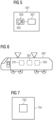
- FIG 6 shows a rail vehicle 601.
- the rail vehicle 601 includes, for example, the device 201 or the system 301 of FIG 3 and/or the system 501 of FIG 5 .
- the graphical elements are shown in dashed lines. Furthermore, the corresponding squares of the device 201, the system 301 and the system 501 were used as placeholders for the other elements or components of the device 201, the system 301 and the system 501.
- the rail vehicle 601 can only include the device 201 or only the system 301 or only the system 501.
- rail vehicle 601 may include both system 301 and system 501.
- FIG 7 shows a machine-readable storage medium 701 on which computer program 703 is stored.
- the computer program 703 includes instructions that, when the computer program 703 is executed by a computer, cause the computer to carry out a method according to the first aspect and/or according to the fourth aspect.
Landscapes
- Engineering & Computer Science (AREA)
- Mechanical Engineering (AREA)
- Image Processing (AREA)
- Closed-Circuit Television Systems (AREA)
- Traffic Control Systems (AREA)
Applications Claiming Priority (1)
| Application Number | Priority Date | Filing Date | Title |
|---|---|---|---|
| DE102022208821.2A DE102022208821A1 (de) | 2022-08-25 | 2022-08-25 | Konzept zum Detektieren einer sich in einer Umgebung eines Schienenfahrzeugs befindenden Anomalie |
Publications (2)
| Publication Number | Publication Date |
|---|---|
| EP4339068A2 true EP4339068A2 (fr) | 2024-03-20 |
| EP4339068A3 EP4339068A3 (fr) | 2024-05-22 |
Family
ID=87202027
Family Applications (1)
| Application Number | Title | Priority Date | Filing Date |
|---|---|---|---|
| EP23184460.6A Pending EP4339068A3 (fr) | 2022-08-25 | 2023-07-10 | Concept de détection d'une anomalie se trouvant dans un environnement d'un véhicule ferroviaire |
Country Status (2)
| Country | Link |
|---|---|
| EP (1) | EP4339068A3 (fr) |
| DE (1) | DE102022208821A1 (fr) |
Cited By (2)
| Publication number | Priority date | Publication date | Assignee | Title |
|---|---|---|---|---|
| CN119478057A (zh) * | 2024-10-25 | 2025-02-18 | 象山润泽交通设施有限公司 | 一种新型的轨道几何参数检测方法 |
| AT528279A1 (de) * | 2024-05-06 | 2025-11-15 | Avl List Gmbh | Verfahren zum halbautomatischen Markieren von relevanten Vorfällen in Messserien |
Families Citing this family (1)
| Publication number | Priority date | Publication date | Assignee | Title |
|---|---|---|---|---|
| DE102024207864A1 (de) | 2024-08-19 | 2026-02-19 | Siemens Mobility GmbH | Landkarte eines Schienenstreckensystems mit Sensorparameterdaten |
Family Cites Families (7)
| Publication number | Priority date | Publication date | Assignee | Title |
|---|---|---|---|---|
| DE10353212A1 (de) | 2003-11-13 | 2005-06-23 | Db Netz Ag | Verfahren und Vorrichtung zur Erkennung und Vermessung von Vegetation im Umfeld von Verkehrswegen |
| CN105636853B (zh) * | 2013-07-31 | 2018-04-24 | 铁路视像有限公司 | 用于障碍物识别和避开的系统和方法 |
| US9575007B2 (en) | 2014-04-03 | 2017-02-21 | General Electric Company | Route examination system and method |
| US11021177B2 (en) | 2016-10-20 | 2021-06-01 | Rail Vision Ltd | System and method for object and obstacle detection and classification in collision avoidance of railway applications |
| US20190039633A1 (en) | 2017-08-02 | 2019-02-07 | Panton, Inc. | Railroad track anomaly detection |
| DE102018204881A1 (de) | 2018-03-29 | 2019-10-02 | Siemens Aktiengesellschaft | Verfahren zur Objekterkennung für ein Fahrzeug mit einer Thermografiekamera und modifizierter Entrauschungsfilter |
| US20210223363A1 (en) | 2020-01-16 | 2021-07-22 | Outsight SA | Object detection on a path of travel and obstacle detection on railway tracks using free space information |
-
2022
- 2022-08-25 DE DE102022208821.2A patent/DE102022208821A1/de not_active Withdrawn
-
2023
- 2023-07-10 EP EP23184460.6A patent/EP4339068A3/fr active Pending
Cited By (2)
| Publication number | Priority date | Publication date | Assignee | Title |
|---|---|---|---|---|
| AT528279A1 (de) * | 2024-05-06 | 2025-11-15 | Avl List Gmbh | Verfahren zum halbautomatischen Markieren von relevanten Vorfällen in Messserien |
| CN119478057A (zh) * | 2024-10-25 | 2025-02-18 | 象山润泽交通设施有限公司 | 一种新型的轨道几何参数检测方法 |
Also Published As
| Publication number | Publication date |
|---|---|
| DE102022208821A1 (de) | 2024-03-07 |
| EP4339068A3 (fr) | 2024-05-22 |
Similar Documents
| Publication | Publication Date | Title |
|---|---|---|
| EP4339068A2 (fr) | Concept de détection d'une anomalie se trouvant dans un environnement d'un véhicule ferroviaire | |
| DE102016120505B4 (de) | Koordiniertes Testen in Fahrzeugpulks | |
| DE102016212326A1 (de) | Verfahren zur Verarbeitung von Sensordaten für eine Position und/oder Orientierung eines Fahrzeugs | |
| WO2019201565A1 (fr) | Procédé, dispositif et support d'enregistrement lisible par ordinateur comprenant des instructions pour le traitement de données de capteur | |
| DE102015203354A1 (de) | Einstellungen von fahrzeugbedienerüberwachung und betriebsabläufen | |
| DE102012024874A1 (de) | Verfahren und Vorrichtung zum prädikativen Ermitteln eines Parameterwertes einer von einem Fahrzeug befahrbaren Oberfläche | |
| DE102016224212A1 (de) | Automatisierte Freiraumerkennung mittels Differenzanalyse für Fahrzeuge | |
| DE102015224192A1 (de) | Erkennen einer Freifläche | |
| DE102021116703A1 (de) | Verfahren und System zur Vorhersage einer Trajektorie eines Zielfahrzeugs in einer Umgebung eines Fahrzeugs | |
| DE102018100487A1 (de) | Objektverfolgung durch unüberwachtes lernen | |
| DE102017128276A1 (de) | Betrieb einer kühlergrilljalousie | |
| DE102021200822A1 (de) | Verfahren und Vorrichtung zur Sensordatenverarbeitung | |
| DE102022108656A1 (de) | Neuronales quantilnetz | |
| EP4088224A1 (fr) | Procédé de réunion de plusieurs ensembles de données pour la génération d'un modèle de voie actuel d'une voie de circulation et dispositif de traitement de données | |
| DE102017212513A1 (de) | Verfahren und System zum Detektieren eines freien Bereiches innerhalb eines Parkplatzes | |
| DE102020129802A1 (de) | Fahrzeugbetriebskennzeichnung | |
| DE102021106900A1 (de) | Fahrzeugunsicherheitsaustausch | |
| DE112016007335T5 (de) | Autonome fahrzeugsteuerung durch komparative übergangsprognose | |
| DE102020214123A1 (de) | Verfahren zur Erfassung eines Umfelds eines ersten Sensorsystems | |
| DE102014210752A1 (de) | Verfahren und Vorrichtung zum Überwachen einer Solltrajektorie eines Fahrzeugs | |
| EP4029758A1 (fr) | Surveillance embarquée à sécurité critique de l'environnement d'un véhicule ferroviaire | |
| WO2023131603A1 (fr) | Procédé d'optimisation de la détection d'environnement pour un système d'aide à la conduite au moyen d'un système de capteur de référence supplémentaire | |
| WO2020160798A1 (fr) | Procédé et dispositif de fusion de données de capteur pour un véhicule | |
| EP3625106B1 (fr) | Procédé d'adaptation à commande sensorielle de paramètres de fusion à des conditions météorologiques dans une unité odométrique d'un véhicule ferroviaire | |
| WO2023012096A1 (fr) | Procédé et dispositif de génération de carte pour un véhicule permettant de produire une carte haute résolution d'une surface de sol dans un environnement de véhicule |
Legal Events
| Date | Code | Title | Description |
|---|---|---|---|
| PUAI | Public reference made under article 153(3) epc to a published international application that has entered the european phase |
Free format text: ORIGINAL CODE: 0009012 |
|
| STAA | Information on the status of an ep patent application or granted ep patent |
Free format text: STATUS: THE APPLICATION HAS BEEN PUBLISHED |
|
| AK | Designated contracting states |
Kind code of ref document: A2 Designated state(s): AL AT BE BG CH CY CZ DE DK EE ES FI FR GB GR HR HU IE IS IT LI LT LU LV MC ME MK MT NL NO PL PT RO RS SE SI SK SM TR |
|
| PUAL | Search report despatched |
Free format text: ORIGINAL CODE: 0009013 |
|
| AK | Designated contracting states |
Kind code of ref document: A3 Designated state(s): AL AT BE BG CH CY CZ DE DK EE ES FI FR GB GR HR HU IE IS IT LI LT LU LV MC ME MK MT NL NO PL PT RO RS SE SI SK SM TR |
|
| RIC1 | Information provided on ipc code assigned before grant |
Ipc: B61L 23/04 20060101AFI20240417BHEP |
|
| STAA | Information on the status of an ep patent application or granted ep patent |
Free format text: STATUS: REQUEST FOR EXAMINATION WAS MADE |
|
| 17P | Request for examination filed |
Effective date: 20241120 |
|
| RBV | Designated contracting states (corrected) |
Designated state(s): AL AT BE BG CH CY CZ DE DK EE ES FI FR GB GR HR HU IE IS IT LI LT LU LV MC ME MK MT NL NO PL PT RO RS SE SI SK SM TR |
|
| RAP3 | Party data changed (applicant data changed or rights of an application transferred) |
Owner name: SIEMENS MOBILITY GMBH |