EP4295115B1 - System und verfahren zum trainieren eines neuronalen netzwerks für geografische informationen - Google Patents
System und verfahren zum trainieren eines neuronalen netzwerks für geografische informationen Download PDFInfo
- Publication number
- EP4295115B1 EP4295115B1 EP21844313.3A EP21844313A EP4295115B1 EP 4295115 B1 EP4295115 B1 EP 4295115B1 EP 21844313 A EP21844313 A EP 21844313A EP 4295115 B1 EP4295115 B1 EP 4295115B1
- Authority
- EP
- European Patent Office
- Prior art keywords
- geographical information
- data
- neural network
- actual
- map
- Prior art date
- Legal status (The legal status is an assumption and is not a legal conclusion. Google has not performed a legal analysis and makes no representation as to the accuracy of the status listed.)
- Active
Links
Images




Classifications
-
- G—PHYSICS
- G01—MEASURING; TESTING
- G01C—MEASURING DISTANCES, LEVELS OR BEARINGS; SURVEYING; NAVIGATION; GYROSCOPIC INSTRUMENTS; PHOTOGRAMMETRY OR VIDEOGRAMMETRY
- G01C21/00—Navigation; Navigational instruments not provided for in groups G01C1/00 - G01C19/00
- G01C21/20—Instruments for performing navigational calculations
-
- G—PHYSICS
- G01—MEASURING; TESTING
- G01C—MEASURING DISTANCES, LEVELS OR BEARINGS; SURVEYING; NAVIGATION; GYROSCOPIC INSTRUMENTS; PHOTOGRAMMETRY OR VIDEOGRAMMETRY
- G01C21/00—Navigation; Navigational instruments not provided for in groups G01C1/00 - G01C19/00
- G01C21/38—Electronic maps specially adapted for navigation; Updating thereof
- G01C21/3804—Creation or updating of map data
-
- G—PHYSICS
- G06—COMPUTING OR CALCULATING; COUNTING
- G06F—ELECTRIC DIGITAL DATA PROCESSING
- G06F18/00—Pattern recognition
- G06F18/20—Analysing
- G06F18/21—Design or setup of recognition systems or techniques; Extraction of features in feature space; Blind source separation
- G06F18/214—Generating training patterns; Bootstrap methods, e.g. bagging or boosting
-
- G—PHYSICS
- G06—COMPUTING OR CALCULATING; COUNTING
- G06V—IMAGE OR VIDEO RECOGNITION OR UNDERSTANDING
- G06V10/00—Arrangements for image or video recognition or understanding
- G06V10/70—Arrangements for image or video recognition or understanding using pattern recognition or machine learning
- G06V10/77—Processing image or video features in feature spaces; using data integration or data reduction, e.g. principal component analysis [PCA] or independent component analysis [ICA] or self-organising maps [SOM]; Blind source separation
- G06V10/772—Determining representative reference patterns, e.g. averaging or distorting patterns; Generating dictionaries
-
- G—PHYSICS
- G06—COMPUTING OR CALCULATING; COUNTING
- G06V—IMAGE OR VIDEO RECOGNITION OR UNDERSTANDING
- G06V10/00—Arrangements for image or video recognition or understanding
- G06V10/70—Arrangements for image or video recognition or understanding using pattern recognition or machine learning
- G06V10/77—Processing image or video features in feature spaces; using data integration or data reduction, e.g. principal component analysis [PCA] or independent component analysis [ICA] or self-organising maps [SOM]; Blind source separation
- G06V10/774—Generating sets of training patterns; Bootstrap methods, e.g. bagging or boosting
-
- G—PHYSICS
- G06—COMPUTING OR CALCULATING; COUNTING
- G06V—IMAGE OR VIDEO RECOGNITION OR UNDERSTANDING
- G06V10/00—Arrangements for image or video recognition or understanding
- G06V10/70—Arrangements for image or video recognition or understanding using pattern recognition or machine learning
- G06V10/82—Arrangements for image or video recognition or understanding using pattern recognition or machine learning using neural networks
-
- G—PHYSICS
- G06—COMPUTING OR CALCULATING; COUNTING
- G06V—IMAGE OR VIDEO RECOGNITION OR UNDERSTANDING
- G06V30/00—Character recognition; Recognising digital ink; Document-oriented image-based pattern recognition
- G06V30/40—Document-oriented image-based pattern recognition
- G06V30/42—Document-oriented image-based pattern recognition based on the type of document
- G06V30/422—Technical drawings; Geographical maps
Definitions
- the present invention relates to a system and a method for training a neural network for geographical information, and particularly relates to a system and a method for updating geographical information using the neural network.
- the lane level maps generally comprise a list of line segments which may define location of scene elements like lane markers, kerbs, and drivable routes through intersections.
- occupancy grid maps For indoor robotics, most work has been focused on occupancy grid maps. These may generally be easy to build and maintain given that a laser scanner is available on the robot.
- the grid basically represents which cells contain obstacles.
- small mobile robots may require high resolution semantic grid maps which have many more degrees of freedom and are harder to maintain incrementally.
- Cells may contain a wide range of categories relevant for navigation, such as footpath, road, kerb, grass, traffic light crossing etc. Errors tend to cause more problems in the navigation of the robot compared to occupancy grid maps (for example, when used indoors).
- semantic grid maps are generally built using the following process:
- Document US 2018/275658 A1 discloses an autonomous control system configured to generate synthetic data that reflect simulated environments, and to use the generated synthetic data to train computer models for various detection and control algorithms.
- the present invention seeks to provide a system and a method that addresses the aforementioned need at least in part.
- each training step may span multiple iterations, and the output of the neural network at earlier iterations may become the second data in subsequent iterations.
- the present invention can train the neural network to learn how to build large scale consistent maps or update the semantic grid maps over time, without manual operations. Accordingly, the present invention is able to reduce costs and efforts required to maintain the semantic grid maps.
- a system for training a neural network for geographical information comprising: the neural network; and a processor operable to generate an environment from actual geographical information, and to simulate a robot moving in the environment to obtain first data from the simulation of the robot, characterised in that: the processor is operable to produce corrupted geographical information from the actual geographical information to obtain second data from the corrupted geographical information, and the neural network is operable to receive the first and the second data, construct predicted geographical information based on the first and second data, and compare the actual geographical information and the predicted geographical information to train the neural network.
- the generated environment includes a 3D (three-dimensional) environment.
- the processor is operable to generate the 3D environment from a top-down view of the actual geographical information.
- the processor is operable to delete at least a part of the actual geographical information, add a spatial distortion on the actual geographical information, or add incorrect categories or noise on the actual geographical information, to produce the corrupted geographical information.
- the neural network is operable to predict at least one region in the actual geographical information that needs to be updated.
- the neural network is operable to construct the predicted geographical information based on information relevant to the at least one region that needs to be updated.
- the neural network is operable to correct or update at least one flaw in the actual geographical information by the training.
- the first data includes simulated sensory data from the robot's point of view.
- the actual geographical information includes an actual map
- the corrupted geographical information includes a corrupted map
- the predicted geographical information includes a predicted map
- each training may span multiple iterations.
- the output of the neural network at earlier iterations may become the second data in subsequent iterations.
- a method of training a neural network for geographical information comprising steps of: generating an environment from actual geographical information; simulating a robot moving in the environment to obtain first data from the simulation of the robot; producing corrupted geographical information from the actual geographical information to obtain second data from the corrupted geographical information; receiving, by the neural network, the first and the second data; constructing predicted geographical information based on the first and second data; and comparing the actual geographical information and the predicted geographical information to train the neural network.
- the step of generating an environment from actual geographical information comprising a step of: generating a 3D environment from a top-down view of the actual geographical information.
- the step of constructing predicted geographical information based on the first and second data comprising a step of: predicting at least one region in the actual geographical information that needs to be updated.
- the step of constructing predicted geographical information based on the first and second data comprising a step of: constructing the predicted geographical information based on information relevant to the at least one region that needs to be updated.
- the method further comprises a step of: correcting or updating at least one flaw in the actual geographical information by the training.
- Fig. 1 is a block diagram in accordance with an embodiment of the present invention.
- a system 100 comprises a processor 110 and a neural network 120.
- the processor 110 may be a controller or a control unit of a device. In some other embodiments, the processor 110 may be a stand-alone device such as a computing device.
- the computing device may include, but not be limited to, a smartphone, a tablet computer, a laptop computer, a desktop computer and a wearable device.
- the wearable device may include, but not be limited to, a smart watch, a smart glasses or a mobile virtual reality headset.
- the processor 110 may be a part of or an element of the neural network 120.
- the processor 110 may include a plurality of controllers or a plurality of computing devices. In some embodiments, the plurality of computing devices 110 may communicate with each other.
- the neural network 120 may be a computer system modelled on a human brain and/or a nervous system.
- the processor 110 and the neural network 120 are operable to communicate with each other.
- the processor 110 may generate an environment from actual geographical information, for example an actual map.
- the actual map is also referred to as a global (i.e. of an arbitrarily large area) semantic (i.e. with classification of different obstacle/ground surface types) map.
- the "actual map” is referred to as either a template map (which is manually specified via a step of "manually specifying a template semantic map - to be described below) or an actual map for real environments (which is not obtainable - the user can only make predictions for this via the output of the neural network when executed on real data).
- the generated environment includes a 3D (three-dimensional) environment.
- the processor 110 may generate the 3D environment from a top-down view of the actual geographical information, for example the actual map.
- the processor 110 may simulate a robot moving in the environment, to obtain data (hereinafter referred to as "first data") from the simulation of the robot.
- first data includes simulated sensory data from the robot's point of view.
- the processor 110 may generate sensory data for which a user knows exact parameters of the underlying actual map that was used to construct the simulation.
- the present invention can train the neural network 120 which can solve an inverse problem (i.e. instead of a problem of transforming the semantic grid to the sensory data, performs a relatively harder problem of transforming the sensory data to the semantic grid).
- the first data may be obtained from the simulation of the robot.
- the processor 110 may obtain the first data and provide the neural network 120 with the first data, and thus the neural network 120 may receive the first data from the processor 110.
- the neural network 120 may obtain the first data directly.
- the processor 110 may produce corrupted geographical information, for example a corrupted map, from the actual geographical information, for example the actual map, to obtain data (hereinafter referred to as "second data") from the corrupted geographical information.
- second data data
- the processor 110 may delete at least a part of the actual geographical information, for example the actual map, in order to produce the corrupted geographical information, for example the corrupted map.
- the processor 110 may add a spatial distortion on the actual geographical information, for example the actual map, in order to produce the corrupted geographical information, for example the corrupted map.
- the processor 110 may add incorrect categories or noise on the actual geographical information, for example the actual map, in order to produce the corrupted geographical information, for example the corrupted map.
- the second data may be obtained from the corrupted geographical information, for example the corrupted map.
- the processor 110 may obtain the second data and provide the neural network 120 with the second data, and thus the neural network 120 may receive the second data from the processor 110.
- the neural network 120 may obtain the second data directly.
- the neural network 120 may construct predicted geographical information, for example a predicted map, based on the first data and second data.
- the neural network 120 may predict at least one region in the actual geographical information, for example the actual map, that needs to be updated. The neural network 120 may then construct the predicted geographical information, for example the predicted map, based on information relevant to the at least one region that needs to be updated.
- the neural network 120 may then compare the actual geographical information, for example the actual map, and the predicted geographical information, for example the predicted map, so as to train the neural network 120.
- the neural network 120 may correct or update at least one flaw in the actual geographical information, for example the actual map, by the training of the neural network 120.
- the actual geographical information for example the actual map
- the actual geographical information is a mutable buffer that may get incrementally updated over time. For example, if a vehicle trajectory covers the same area twice, the neural network 120 may update the buffer twice. It may be appreciated that the mutable buffer is not necessarily needed during the training of the neural network 120.
- the present invention may comprise the three (3) phases as follows.
- Fig. 2 is a conceptual diagram showing phase 1 in accordance with an embodiment of the present invention.
- Phase 1 Collecting synthetic training data
- Phase 2 Training the neural network 120 to incrementally repair the actual map given sensory data
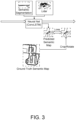
- Fig. 3 is a conceptual diagram showing a conventional system architecture for neural network 120 based on grid mapping (also referred to as “local mapper”).
- Fig. 4 is a conceptual diagram showing a system architecture in which a global map is added, in accordance with an embodiment of the present invention (also referred to as “local/global data fusion mapper").
- Figs. 3 and 4 elucidate the difference between the commonly used system architecture for the neural network 120 based on the grid mapping (shown in Fig. 3 ), and the system architecture in accordance with an embodiment of the present invention (shown in Fig. 4 ).
- the method in accordance with an embodiment of the present invention may make use of a global semantic map buffer, which allows the neural network 120 to perform information fusion between the sensor data and the prior map.
- the method in accordance with an embodiment of the present invention may make use of a novel training mechanism which specifies a method of training based on an artificially corrupted global map, and a method to unwrap the training process over multiple iterations of the map update mechanism. As such, the neural network 120 can better learn to perform incremental updates to the map.
- Fig. 5 is a flowchart in accordance with an embodiment of the present invention.
- the processor 110 may generate the environment, for example the 3D environment, from the actual geographical information (S110).
- the processor 110 may generate the 3D environment from the top-down view of the actual geographical information.
- the processor 110 may then simulate the robot moving in the environment, for example the 3D environment (S120).
- the processor 110 may generate the first data, for example the sensory data from the robot's point of view.
- the neural network 120 may receive the first data.
- the processor 110 may produce corrupted geographical information from the actual geographical information (S130). Thus, the processor 110 may generate the second data from the corrupted geographical information.
- the neural network 120 may receive the second data.
- the neural network 120 which has received the first data and the second data may construct the predicted geographical information based on the first data and the second data (S140).
- the neural network 120 may predict at least one region in the actual geographical information that needs to be updated, and then construct the predicted geographical information based on information relevant to the at least one region that needs to be updated.
- the neural network 120 may then compare the actual geographical information and the predicted geographical information so as to train the neural network 120 (S150).
- the neural network 120 may correct or update at least one flaw in the actual geographical information, by the training.
- the present invention can also be used for creation of detailed maps for purposes other than robot navigation (for example, constructing and/or maintaining precise maps of construction sites, agricultural fields, search and rescue sites, etc.).
- System 110 Processor 120: Neural Network
Landscapes
- Engineering & Computer Science (AREA)
- Remote Sensing (AREA)
- Radar, Positioning & Navigation (AREA)
- Theoretical Computer Science (AREA)
- General Physics & Mathematics (AREA)
- Physics & Mathematics (AREA)
- Computer Vision & Pattern Recognition (AREA)
- Artificial Intelligence (AREA)
- Evolutionary Computation (AREA)
- Multimedia (AREA)
- Databases & Information Systems (AREA)
- Medical Informatics (AREA)
- Automation & Control Theory (AREA)
- Health & Medical Sciences (AREA)
- Computing Systems (AREA)
- Software Systems (AREA)
- General Health & Medical Sciences (AREA)
- Data Mining & Analysis (AREA)
- Bioinformatics & Cheminformatics (AREA)
- Evolutionary Biology (AREA)
- Bioinformatics & Computational Biology (AREA)
- Life Sciences & Earth Sciences (AREA)
- General Engineering & Computer Science (AREA)
- Control Of Position, Course, Altitude, Or Attitude Of Moving Bodies (AREA)
- Management, Administration, Business Operations System, And Electronic Commerce (AREA)
Claims (10)
- System zum Trainieren eines neuronalen Netzwerks (120) für geografische Informationen, das Folgendes umfasst:
das neuronale Netzwerk (120); und einen Prozessor (110), der betreibbar ist, um eine Umgebung aus tatsächlichen geografischen Informationen zu erzeugen und einen Roboter zu simulieren, der sich in der Umgebung bewegt, um erste Daten aus der Simulation des Roboters zu erhalten, dadurch gekennzeichnet, dass:der Prozessor betreibbar ist, um beschädigte geografische Informationen aus den tatsächlichen geografischen Informationen zu erzeugen, um zweite Daten aus den beschädigten geografischen Informationen zu erhalten, unddas neuronale Netzwerk betreibbar ist, um die ersten und die zweiten Daten zu empfangen, vorhergesagte geografische Informationen basierend auf den ersten und zweiten Daten zu konstruieren, und die tatsächlichen geografischen Informationen und die vorhergesagten geografischen Informationen zu vergleichen, um das neuronale Netzwerk zu trainieren, wobei das neuronale Netzwerk betreibbar ist, um mindestens eine Region, die aktualisiert werden muss, in den tatsächlichen geografischen Informationen vorherzusagen, und um die vorhergesagten geografischen Informationen basierend auf Informationen zu konstruieren, die für die mindestens eine Region, die aktualisiert werden muss, relevant sind. - System nach Anspruch 1, wobei die erzeugte Umgebung eine 3D-(dreidimensionale)-Umgebung einschließt.
- System nach Anspruch 2, wobei der Prozessor betreibbar ist, um die 3D-Umgebung aus einer Draufsicht der tatsächlichen geografischen Informationen zu erzeugen.
- System nach einem der Ansprüche 1 bis 3, wobei der Prozessor betreibbar ist, um mindestens einen Teil der tatsächlichen geografischen Informationen zu löschen, eine räumliche Verzerrung der tatsächlichen geografischen Informationen hinzuzufügen oder falsche Kategorien oder Rauschen der tatsächlichen geografischen Informationen hinzuzufügen, um die beschädigten geografischen Informationen zu erzeugen.
- System nach einem der Ansprüche 1 bis 4, wobei das neuronale Netzwerk betreibbar ist, um mindestens einen Fehler in den tatsächlichen geografischen Informationen durch das Training zu korrigieren oder zu aktualisieren.
- System nach einem der Ansprüche 1 bis 5, wobei die ersten Daten simulierte sensorische Daten aus der Sicht des Roboters beinhalten.
- System nach einem der Ansprüche 1 bis 6, wobei die tatsächlichen geografischen Informationen eine tatsächliche Karte beinhalten, die beschädigten geografischen Informationen eine beschädigte Karte beinhalten und die vorhergesagten geografischen Informationen eine vorhergesagte Karte beinhalten.
- Verfahren zum Trainieren eines neuronalen Netzwerks für geografische Informationen, das die folgenden Schritte umfasst:Erzeugen (S110) einer Umgebung aus tatsächlichen geografischen Informationen;Simulieren (S120) eines Roboters, der sich in der Umgebung bewegt, um erste Daten aus der Simulation des Roboters zu erhalten;Erstellen (S130) von beschädigten geografischen Informationen aus den tatsächlichen geografischen Informationen, um zweite Daten aus den beschädigten geografischen Informationen zu erhalten;Empfangen, durch das neuronale Netzwerk, der ersten und der zweiten Daten;Konstruieren (S140) vorhergesagter geografischer Informationen basierend auf den ersten und zweiten Daten; undVergleichen (S150) der tatsächlichen geografischen Informationen und der vorhergesagten geografischen Informationen, um das neuronale Netzwerk zu trainieren,wobei der Schritt des Konstruierens vorhergesagter geografischer Informationen basierend auf den ersten und zweiten Daten Folgendes umfasst:Vorhersagen mindestens einer Region in den tatsächlichen geografischen Informationen, die aktualisiert werden muss; undErstellen der vorhergesagten geografischen Informationen basierend auf Informationen, die für die mindestens eine Region relevant sind, die aktualisiert werden muss.
- Verfahren nach Anspruch 8, wobei der Schritt des Erzeugens einer Umgebung aus tatsächlichen geografischen Informationen den folgenden Schritt umfasst: Erzeugen einer 3D-Umgebung aus einer Draufsicht der tatsächlichen geografischen Informationen.
- Verfahren nach einem der Ansprüche 8 bis 9, das ferner den folgenden Schritt umfasst: Korrigieren oder Aktualisieren mindestens eines Fehlers in den tatsächlichen geografischen Informationen durch das Training.
Applications Claiming Priority (2)
| Application Number | Priority Date | Filing Date | Title |
|---|---|---|---|
| GB2102197.7A GB2604100A (en) | 2021-02-17 | 2021-02-17 | System and method for training neural network for geographical information |
| PCT/EP2021/087360 WO2022174964A1 (en) | 2021-02-17 | 2021-12-22 | System and method for training neural network for geographical information |
Publications (2)
| Publication Number | Publication Date |
|---|---|
| EP4295115A1 EP4295115A1 (de) | 2023-12-27 |
| EP4295115B1 true EP4295115B1 (de) | 2025-05-28 |
Family
ID=75338883
Family Applications (1)
| Application Number | Title | Priority Date | Filing Date |
|---|---|---|---|
| EP21844313.3A Active EP4295115B1 (de) | 2021-02-17 | 2021-12-22 | System und verfahren zum trainieren eines neuronalen netzwerks für geografische informationen |
Country Status (3)
| Country | Link |
|---|---|
| EP (1) | EP4295115B1 (de) |
| GB (1) | GB2604100A (de) |
| WO (1) | WO2022174964A1 (de) |
Family Cites Families (3)
| Publication number | Priority date | Publication date | Assignee | Title |
|---|---|---|---|---|
| WO2018176000A1 (en) * | 2017-03-23 | 2018-09-27 | DeepScale, Inc. | Data synthesis for autonomous control systems |
| US10606269B2 (en) * | 2017-12-19 | 2020-03-31 | X Development Llc | Semantic obstacle recognition for path planning |
| DE112019001605T5 (de) * | 2018-03-27 | 2020-12-17 | Nvidia Corporation | Trainieren, testen und verifizieren von autonomen maschinen unter verwendung simulierter umgebungen |
-
2021
- 2021-02-17 GB GB2102197.7A patent/GB2604100A/en not_active Withdrawn
- 2021-12-22 WO PCT/EP2021/087360 patent/WO2022174964A1/en not_active Ceased
- 2021-12-22 EP EP21844313.3A patent/EP4295115B1/de active Active
Also Published As
| Publication number | Publication date |
|---|---|
| GB202102197D0 (en) | 2021-03-31 |
| WO2022174964A1 (en) | 2022-08-25 |
| GB2604100A (en) | 2022-08-31 |
| EP4295115A1 (de) | 2023-12-27 |
Similar Documents
| Publication | Publication Date | Title |
|---|---|---|
| US12223593B2 (en) | Detection of misalignment hotspots for high definition maps for navigating autonomous vehicles | |
| US12117298B2 (en) | Distributed processing of pose graphs for generating high definition maps for navigating autonomous vehicles | |
| US20230044625A1 (en) | Systems and Methods for Generating Synthetic Light Detection and Ranging Data via Machine Learning | |
| CN112292581B (zh) | 自动驾驶车辆的相对图集及其生成 | |
| Tabib et al. | Real-Time Information-Theoretic Exploration with Gaussian Mixture Model Maps. | |
| CN117036607B (zh) | 基于隐式神经渲染的自动驾驶场景数据生成方法及系统 | |
| WO2020263248A2 (en) | Worldwide coordinate frame defined by data set correspondences | |
| EP3690750B1 (de) | Verfahren und vorrichtung zur kalibrierung einer physikmaschine eines simulators der virtuellen welt zur verwendung zum lernen einer vorrichtung auf tiefenlernbasis sowie lernverfahren und lernvorrichtung für ein dafür verwendetes echtzustandsnetzwerk | |
| Wen et al. | G²vd planner: Efficient motion planning with grid-based generalized voronoi diagrams | |
| Camps et al. | Learning deep sdf maps online for robot navigation and exploration | |
| Šalanský et al. | Pose consistency KKT-loss for weakly supervised learning of robot-terrain interaction model | |
| EP4295115B1 (de) | System und verfahren zum trainieren eines neuronalen netzwerks für geografische informationen | |
| Klaser et al. | Simulation of an autonomous vehicle with a vision-based navigation system in unstructured terrains using OctoMap | |
| US12422791B2 (en) | Simulation-based training of an autonomous vehicle | |
| Ren et al. | SLAM in autonomous driving | |
| Huang et al. | Adaptive multi-sensor integrated navigation system aided by continuous error map from RSU for autonomous vehicles in urban areas | |
| Yan et al. | A model for learning representations of 3D objects through tactile exploration: effects of object asymmetries and landmarks | |
| Liu et al. | Vehicle trajectory prediction through manual setting and machine learning | |
| Tran et al. | A Novel of Improving the Accuracy of High-Definition Map for Autonomous Vehicle: A Realistic Case Study in Hanoi Area | |
| Kemppi | CREATING HIGH-DEFINITION MAPS WITH LANE EXTRACTION FOR AUTOMATED DRIVING | |
| CN121564715A (zh) | 井工矿道路面重建与可行驶区域自动标注方法 | |
| CN119741330A (zh) | 一种基于激光雷达的可行驶区域分析方法 | |
| CN121521112A (zh) | 一种基于ROS Navigation的轮足式机器狗导航方法及系统 | |
| CN116263335A (zh) | 一种基于视觉与雷达信息融合与强化学习的室内导航方法 | |
| Griffis | System Design of an Autonomous Ground Vehicle for Participation in the 2005 DARPA Grand Challenge |
Legal Events
| Date | Code | Title | Description |
|---|---|---|---|
| STAA | Information on the status of an ep patent application or granted ep patent |
Free format text: STATUS: UNKNOWN |
|
| STAA | Information on the status of an ep patent application or granted ep patent |
Free format text: STATUS: THE INTERNATIONAL PUBLICATION HAS BEEN MADE |
|
| PUAI | Public reference made under article 153(3) epc to a published international application that has entered the european phase |
Free format text: ORIGINAL CODE: 0009012 |
|
| STAA | Information on the status of an ep patent application or granted ep patent |
Free format text: STATUS: REQUEST FOR EXAMINATION WAS MADE |
|
| 17P | Request for examination filed |
Effective date: 20230918 |
|
| AK | Designated contracting states |
Kind code of ref document: A1 Designated state(s): AL AT BE BG CH CY CZ DE DK EE ES FI FR GB GR HR HU IE IS IT LI LT LU LV MC MK MT NL NO PL PT RO RS SE SI SK SM TR |
|
| RAP3 | Party data changed (applicant data changed or rights of an application transferred) |
Owner name: CONTINENTAL AUTOMOTIVE TECHNOLOGIES GMBH |
|
| DAV | Request for validation of the european patent (deleted) | ||
| DAX | Request for extension of the european patent (deleted) | ||
| GRAP | Despatch of communication of intention to grant a patent |
Free format text: ORIGINAL CODE: EPIDOSNIGR1 |
|
| STAA | Information on the status of an ep patent application or granted ep patent |
Free format text: STATUS: GRANT OF PATENT IS INTENDED |
|
| RIC1 | Information provided on ipc code assigned before grant |
Ipc: G01C 21/00 20060101ALI20241220BHEP Ipc: G06V 10/82 20220101ALI20241220BHEP Ipc: G06V 20/56 20220101ALI20241220BHEP Ipc: G01C 21/20 20060101AFI20241220BHEP |
|
| INTG | Intention to grant announced |
Effective date: 20250121 |
|
| GRAS | Grant fee paid |
Free format text: ORIGINAL CODE: EPIDOSNIGR3 |
|
| GRAA | (expected) grant |
Free format text: ORIGINAL CODE: 0009210 |
|
| STAA | Information on the status of an ep patent application or granted ep patent |
Free format text: STATUS: THE PATENT HAS BEEN GRANTED |
|
| AK | Designated contracting states |
Kind code of ref document: B1 Designated state(s): AL AT BE BG CH CY CZ DE DK EE ES FI FR GB GR HR HU IE IS IT LI LT LU LV MC MK MT NL NO PL PT RO RS SE SI SK SM TR |
|
| REG | Reference to a national code |
Ref country code: GB Ref legal event code: FG4D |
|
| REG | Reference to a national code |
Ref country code: CH Ref legal event code: EP |
|
| REG | Reference to a national code |
Ref country code: IE Ref legal event code: FG4D Ref country code: DE Ref legal event code: R096 Ref document number: 602021031510 Country of ref document: DE |
|
| REG | Reference to a national code |
Ref country code: NL Ref legal event code: MP Effective date: 20250528 |
|
| PG25 | Lapsed in a contracting state [announced via postgrant information from national office to epo] |
Ref country code: ES Free format text: LAPSE BECAUSE OF FAILURE TO SUBMIT A TRANSLATION OF THE DESCRIPTION OR TO PAY THE FEE WITHIN THE PRESCRIBED TIME-LIMIT Effective date: 20250528 Ref country code: FI Free format text: LAPSE BECAUSE OF FAILURE TO SUBMIT A TRANSLATION OF THE DESCRIPTION OR TO PAY THE FEE WITHIN THE PRESCRIBED TIME-LIMIT Effective date: 20250528 |
|
| REG | Reference to a national code |
Ref country code: LT Ref legal event code: MG9D |
|
| PG25 | Lapsed in a contracting state [announced via postgrant information from national office to epo] |
Ref country code: GR Free format text: LAPSE BECAUSE OF FAILURE TO SUBMIT A TRANSLATION OF THE DESCRIPTION OR TO PAY THE FEE WITHIN THE PRESCRIBED TIME-LIMIT Effective date: 20250829 Ref country code: NO Free format text: LAPSE BECAUSE OF FAILURE TO SUBMIT A TRANSLATION OF THE DESCRIPTION OR TO PAY THE FEE WITHIN THE PRESCRIBED TIME-LIMIT Effective date: 20250828 |
|
| PG25 | Lapsed in a contracting state [announced via postgrant information from national office to epo] |
Ref country code: NL Free format text: LAPSE BECAUSE OF FAILURE TO SUBMIT A TRANSLATION OF THE DESCRIPTION OR TO PAY THE FEE WITHIN THE PRESCRIBED TIME-LIMIT Effective date: 20250528 Ref country code: PL Free format text: LAPSE BECAUSE OF FAILURE TO SUBMIT A TRANSLATION OF THE DESCRIPTION OR TO PAY THE FEE WITHIN THE PRESCRIBED TIME-LIMIT Effective date: 20250528 |
|
| PG25 | Lapsed in a contracting state [announced via postgrant information from national office to epo] |
Ref country code: BG Free format text: LAPSE BECAUSE OF FAILURE TO SUBMIT A TRANSLATION OF THE DESCRIPTION OR TO PAY THE FEE WITHIN THE PRESCRIBED TIME-LIMIT Effective date: 20250528 |
|
| PG25 | Lapsed in a contracting state [announced via postgrant information from national office to epo] |
Ref country code: HR Free format text: LAPSE BECAUSE OF FAILURE TO SUBMIT A TRANSLATION OF THE DESCRIPTION OR TO PAY THE FEE WITHIN THE PRESCRIBED TIME-LIMIT Effective date: 20250528 |
|
| PG25 | Lapsed in a contracting state [announced via postgrant information from national office to epo] |
Ref country code: RS Free format text: LAPSE BECAUSE OF FAILURE TO SUBMIT A TRANSLATION OF THE DESCRIPTION OR TO PAY THE FEE WITHIN THE PRESCRIBED TIME-LIMIT Effective date: 20250828 |
|
| REG | Reference to a national code |
Ref country code: CH Ref legal event code: W10 Free format text: ST27 STATUS EVENT CODE: U-0-0-W10-W00 (AS PROVIDED BY THE NATIONAL OFFICE) Effective date: 20251022 |
|
| PG25 | Lapsed in a contracting state [announced via postgrant information from national office to epo] |
Ref country code: IS Free format text: LAPSE BECAUSE OF FAILURE TO SUBMIT A TRANSLATION OF THE DESCRIPTION OR TO PAY THE FEE WITHIN THE PRESCRIBED TIME-LIMIT Effective date: 20250928 |
|
| PG25 | Lapsed in a contracting state [announced via postgrant information from national office to epo] |
Ref country code: LV Free format text: LAPSE BECAUSE OF FAILURE TO SUBMIT A TRANSLATION OF THE DESCRIPTION OR TO PAY THE FEE WITHIN THE PRESCRIBED TIME-LIMIT Effective date: 20250528 |
|
| RAP4 | Party data changed (patent owner data changed or rights of a patent transferred) |
Owner name: AUMOVIO GERMANY GMBH |
|
| REG | Reference to a national code |
Ref country code: AT Ref legal event code: MK05 Ref document number: 1798809 Country of ref document: AT Kind code of ref document: T Effective date: 20250528 |
|
| PG25 | Lapsed in a contracting state [announced via postgrant information from national office to epo] |
Ref country code: AT Free format text: LAPSE BECAUSE OF FAILURE TO SUBMIT A TRANSLATION OF THE DESCRIPTION OR TO PAY THE FEE WITHIN THE PRESCRIBED TIME-LIMIT Effective date: 20250528 Ref country code: SM Free format text: LAPSE BECAUSE OF FAILURE TO SUBMIT A TRANSLATION OF THE DESCRIPTION OR TO PAY THE FEE WITHIN THE PRESCRIBED TIME-LIMIT Effective date: 20250528 Ref country code: DK Free format text: LAPSE BECAUSE OF FAILURE TO SUBMIT A TRANSLATION OF THE DESCRIPTION OR TO PAY THE FEE WITHIN THE PRESCRIBED TIME-LIMIT Effective date: 20250528 |
|
| PGFP | Annual fee paid to national office [announced via postgrant information from national office to epo] |
Ref country code: FR Payment date: 20251223 Year of fee payment: 5 |
|
| PG25 | Lapsed in a contracting state [announced via postgrant information from national office to epo] |
Ref country code: CZ Free format text: LAPSE BECAUSE OF FAILURE TO SUBMIT A TRANSLATION OF THE DESCRIPTION OR TO PAY THE FEE WITHIN THE PRESCRIBED TIME-LIMIT Effective date: 20250528 |
|
| PG25 | Lapsed in a contracting state [announced via postgrant information from national office to epo] |
Ref country code: EE Free format text: LAPSE BECAUSE OF FAILURE TO SUBMIT A TRANSLATION OF THE DESCRIPTION OR TO PAY THE FEE WITHIN THE PRESCRIBED TIME-LIMIT Effective date: 20250528 |
|
| REG | Reference to a national code |
Ref country code: DE Ref legal event code: R081 Ref document number: 602021031510 Country of ref document: DE Owner name: AUMOVIO GERMANY GMBH, DE Free format text: FORMER OWNER: CONTINENTAL AUTOMOTIVE TECHNOLOGIES GMBH, 30175 HANNOVER, DE |
|
| PG25 | Lapsed in a contracting state [announced via postgrant information from national office to epo] |
Ref country code: SK Free format text: LAPSE BECAUSE OF FAILURE TO SUBMIT A TRANSLATION OF THE DESCRIPTION OR TO PAY THE FEE WITHIN THE PRESCRIBED TIME-LIMIT Effective date: 20250528 |
|
| PG25 | Lapsed in a contracting state [announced via postgrant information from national office to epo] |
Ref country code: IT Free format text: LAPSE BECAUSE OF FAILURE TO SUBMIT A TRANSLATION OF THE DESCRIPTION OR TO PAY THE FEE WITHIN THE PRESCRIBED TIME-LIMIT Effective date: 20250528 |
|
| REG | Reference to a national code |
Ref country code: DE Ref legal event code: R097 Ref document number: 602021031510 Country of ref document: DE |
|
| PG25 | Lapsed in a contracting state [announced via postgrant information from national office to epo] |
Ref country code: RO Free format text: LAPSE BECAUSE OF FAILURE TO SUBMIT A TRANSLATION OF THE DESCRIPTION OR TO PAY THE FEE WITHIN THE PRESCRIBED TIME-LIMIT Effective date: 20250528 |
|
| PLBE | No opposition filed within time limit |
Free format text: ORIGINAL CODE: 0009261 |
|
| STAA | Information on the status of an ep patent application or granted ep patent |
Free format text: STATUS: NO OPPOSITION FILED WITHIN TIME LIMIT |
|
| REG | Reference to a national code |
Ref country code: CH Ref legal event code: L10 Free format text: ST27 STATUS EVENT CODE: U-0-0-L10-L00 (AS PROVIDED BY THE NATIONAL OFFICE) Effective date: 20260409 |
|
| PGFP | Annual fee paid to national office [announced via postgrant information from national office to epo] |
Ref country code: DE Payment date: 20251231 Year of fee payment: 5 |