EP4138057A1 - Procédé de sélection d'itinéraire pour véhicule de mesure - Google Patents
Procédé de sélection d'itinéraire pour véhicule de mesure Download PDFInfo
- Publication number
- EP4138057A1 EP4138057A1 EP21191928.7A EP21191928A EP4138057A1 EP 4138057 A1 EP4138057 A1 EP 4138057A1 EP 21191928 A EP21191928 A EP 21191928A EP 4138057 A1 EP4138057 A1 EP 4138057A1
- Authority
- EP
- European Patent Office
- Prior art keywords
- route
- data
- recording
- vehicle
- routes
- Prior art date
- Legal status (The legal status is an assumption and is not a legal conclusion. Google has not performed a legal analysis and makes no representation as to the accuracy of the status listed.)
- Pending
Links
- 238000000034 method Methods 0.000 title claims abstract description 27
- 230000002787 reinforcement Effects 0.000 claims abstract description 24
- 230000007613 environmental effect Effects 0.000 claims abstract description 22
- 230000006870 function Effects 0.000 claims abstract description 11
- 239000013598 vector Substances 0.000 claims description 35
- 239000003795 chemical substances by application Substances 0.000 claims description 24
- 238000010801 machine learning Methods 0.000 claims description 17
- 238000012549 training Methods 0.000 claims description 11
- 238000004590 computer program Methods 0.000 claims description 4
- 230000000875 corresponding effect Effects 0.000 description 9
- 238000012545 processing Methods 0.000 description 7
- 238000010295 mobile communication Methods 0.000 description 6
- 230000009471 action Effects 0.000 description 4
- 230000008859 change Effects 0.000 description 4
- 238000013480 data collection Methods 0.000 description 4
- 238000001514 detection method Methods 0.000 description 4
- 230000011218 segmentation Effects 0.000 description 4
- 238000010276 construction Methods 0.000 description 3
- 238000011161 development Methods 0.000 description 3
- 230000018109 developmental process Effects 0.000 description 3
- 230000007774 longterm Effects 0.000 description 3
- 238000010200 validation analysis Methods 0.000 description 3
- 230000002776 aggregation Effects 0.000 description 2
- 238000004220 aggregation Methods 0.000 description 2
- 230000006399 behavior Effects 0.000 description 2
- 230000002596 correlated effect Effects 0.000 description 2
- 238000013507 mapping Methods 0.000 description 2
- 241000269400 Sirenidae Species 0.000 description 1
- 230000001133 acceleration Effects 0.000 description 1
- 238000013528 artificial neural network Methods 0.000 description 1
- 239000010426 asphalt Substances 0.000 description 1
- 230000005540 biological transmission Effects 0.000 description 1
- 230000015556 catabolic process Effects 0.000 description 1
- 238000004891 communication Methods 0.000 description 1
- 230000001276 controlling effect Effects 0.000 description 1
- 238000010586 diagram Methods 0.000 description 1
- 230000035622 drinking Effects 0.000 description 1
- 230000004927 fusion Effects 0.000 description 1
- 238000010606 normalization Methods 0.000 description 1
- 230000003068 static effect Effects 0.000 description 1
- 238000013519 translation Methods 0.000 description 1
Images


Classifications
-
- G—PHYSICS
- G08—SIGNALLING
- G08G—TRAFFIC CONTROL SYSTEMS
- G08G1/00—Traffic control systems for road vehicles
- G08G1/01—Detecting movement of traffic to be counted or controlled
- G08G1/0104—Measuring and analyzing of parameters relative to traffic conditions
- G08G1/0108—Measuring and analyzing of parameters relative to traffic conditions based on the source of data
- G08G1/0112—Measuring and analyzing of parameters relative to traffic conditions based on the source of data from the vehicle, e.g. floating car data [FCD]
-
- G—PHYSICS
- G01—MEASURING; TESTING
- G01C—MEASURING DISTANCES, LEVELS OR BEARINGS; SURVEYING; NAVIGATION; GYROSCOPIC INSTRUMENTS; PHOTOGRAMMETRY OR VIDEOGRAMMETRY
- G01C21/00—Navigation; Navigational instruments not provided for in groups G01C1/00 - G01C19/00
- G01C21/26—Navigation; Navigational instruments not provided for in groups G01C1/00 - G01C19/00 specially adapted for navigation in a road network
- G01C21/34—Route searching; Route guidance
- G01C21/3453—Special cost functions, i.e. other than distance or default speed limit of road segments
- G01C21/3461—Preferred or disfavoured areas, e.g. dangerous zones, toll or emission zones, intersections, manoeuvre types, segments such as motorways, toll roads, ferries
-
- G—PHYSICS
- G01—MEASURING; TESTING
- G01C—MEASURING DISTANCES, LEVELS OR BEARINGS; SURVEYING; NAVIGATION; GYROSCOPIC INSTRUMENTS; PHOTOGRAMMETRY OR VIDEOGRAMMETRY
- G01C21/00—Navigation; Navigational instruments not provided for in groups G01C1/00 - G01C19/00
- G01C21/26—Navigation; Navigational instruments not provided for in groups G01C1/00 - G01C19/00 specially adapted for navigation in a road network
- G01C21/34—Route searching; Route guidance
- G01C21/3453—Special cost functions, i.e. other than distance or default speed limit of road segments
- G01C21/3492—Special cost functions, i.e. other than distance or default speed limit of road segments employing speed data or traffic data, e.g. real-time or historical
-
- G—PHYSICS
- G06—COMPUTING; CALCULATING OR COUNTING
- G06N—COMPUTING ARRANGEMENTS BASED ON SPECIFIC COMPUTATIONAL MODELS
- G06N20/00—Machine learning
-
- G—PHYSICS
- G06—COMPUTING; CALCULATING OR COUNTING
- G06N—COMPUTING ARRANGEMENTS BASED ON SPECIFIC COMPUTATIONAL MODELS
- G06N3/00—Computing arrangements based on biological models
- G06N3/004—Artificial life, i.e. computing arrangements simulating life
- G06N3/006—Artificial life, i.e. computing arrangements simulating life based on simulated virtual individual or collective life forms, e.g. social simulations or particle swarm optimisation [PSO]
-
- G—PHYSICS
- G08—SIGNALLING
- G08G—TRAFFIC CONTROL SYSTEMS
- G08G1/00—Traffic control systems for road vehicles
- G08G1/01—Detecting movement of traffic to be counted or controlled
- G08G1/0104—Measuring and analyzing of parameters relative to traffic conditions
- G08G1/0125—Traffic data processing
- G08G1/0129—Traffic data processing for creating historical data or processing based on historical data
-
- G—PHYSICS
- G08—SIGNALLING
- G08G—TRAFFIC CONTROL SYSTEMS
- G08G1/00—Traffic control systems for road vehicles
- G08G1/01—Detecting movement of traffic to be counted or controlled
- G08G1/0104—Measuring and analyzing of parameters relative to traffic conditions
- G08G1/0137—Measuring and analyzing of parameters relative to traffic conditions for specific applications
- G08G1/0145—Measuring and analyzing of parameters relative to traffic conditions for specific applications for active traffic flow control
-
- G—PHYSICS
- G07—CHECKING-DEVICES
- G07C—TIME OR ATTENDANCE REGISTERS; REGISTERING OR INDICATING THE WORKING OF MACHINES; GENERATING RANDOM NUMBERS; VOTING OR LOTTERY APPARATUS; ARRANGEMENTS, SYSTEMS OR APPARATUS FOR CHECKING NOT PROVIDED FOR ELSEWHERE
- G07C5/00—Registering or indicating the working of vehicles
- G07C5/008—Registering or indicating the working of vehicles communicating information to a remotely located station
Definitions
- the present disclosure relates to the field of recording data by a fleet of data recording vehicles and uploading the recording data to a host data collecting system.
- the recording data recorded by the recording vehicles while driving along a route can include raw data captured by sensors, data derived from the raw data (for example object detection data), and/or external data (for example GPS data, weather data, etc.).
- data derived from the raw data for example object detection data
- external data for example GPS data, weather data, etc.
- a known method for recording data for algorithm development and validation purposes for ADAS uses a single vehicle or a fleet of vehicles outfitted with the desired sensor hardware including typically radars, lidars and cameras. The drivers of the vehicles then drive around locations to provide valuable and useful data for development and validation purposes. While each vehicle drives, the sensor data is logged using an automotive data recording device onto a hard drive equipped in the vehicle, as disclosed for example in US6073063A . After recording, the hard-drives of the recording vehicles are brought back to a collection site for further distribution and storage of the data.
- the present disclosure concerns a computer-implemented method, carried out by a vehicle data recording device in a vehicle, including the following steps:
- the present method allows a vehicle that has received a recording target to drive and record data along a route that is expected to optimize the rewards for successfully uploading the recording data to the host data collecting system, instead of driving randomly.
- the rewards are generated by the host collecting system, taking into account the recording target.
- the step of generating a route encoding for each route includes the steps of:
- the step of generating a feature vector for each route segment includes a step of encoding into numerical values past information on what happened just before the current time to to form another component of the feature vector.
- the method can further include, for each route segment, a step of inputting the corresponding feature vector into a machine learning system of value prediction for the plurality of metrics and providing, at the output of the machine learning system, a metric value prediction vector including predicted values of said route segment for the plurality of metrics.
- the metric value prediction vector of each route segment can further include an uncertainty information.
- the metric value prediction vectors of the segments of each route being grouped into a high-dimensional route encoding the high-dimensional route encodings of the plurality of routes are translated into fixed-length route encodings of lower dimension and the route encodings of fixed-length are provided as inputs to the reinforcement learning agent.
- a selector can pre-select a short list of the most promising route encodings and only the short list of route encodings can be provided as input to the reinforcement learning agent.
- the method further includes, in a preliminary step: obtaining historical data related to a plurality of recordings performed when driving along given past routes;
- the plurality of routes can be determined by using a tree expansion algorithm.
- the present disclosure also concerns a vehicle data recording device, including
- the present disclosure also concerns a computer program including instructions to cause the above defined vehicle data recording device to execute the steps of the method previously defined.
- the present disclosure further concerns a computer-readable medium having stored there on the above defined computer program.
- the present disclosure concerns a computer-implemented method, carried out by an in-vehicle data recording device 140 in a recording vehicle 100, for recording data while the vehicle 100 drives along a selected route and uploading at least part of the recording data to a host data collecting system 200.
- the route along which the data is recorded is selected among a plurality of routes in order to optimize rewards from the host data collecting system 200 after and/or during uploading recording data.
- Figure 1 shows a distributed system for collecting data from a fleet or a plurality of recording vehicles 100 by the host data collecting system 200.
- the recording vehicles 100 can communicate with the host data collecting system 200 over-the-air, for example through a mobile communication network 300 such as a 5G network.
- a mobile communication network 300 such as a 5G network.
- the data from each recording vehicle 100 can include different types of data such as raw data, derived data and/or external data.
- the data collected from the vehicle 100 is recorded over time, typically while the vehicle is driving along a route.
- the raw data (also called elementary data or source data) is data that has not been processed.
- the raw data includes in a non-limitative manner sensor data from sensors mounted in the vehicle 100 (such as radars, lidars and cameras), GPS data, speed data, yaw rate data, etc...
- the derived data include data derived from raw data by data processing.
- the data processing can be carried out by hardware means and/or software means in the vehicle 100, that execute processing operations and/or algorithms (for example machine learning algorithms or any other type of algorithms).
- Some in-vehicle hardware and software components can perform an object detection based on radar, lidar or camera data (with or without sensor fusion), a semantic segmentation on camera data, an encoding of signatures describing various aspects of an environmental information (in the environment of the vehicle), a computation of data structures and/or statistical information derived from an object detection module or another algorithmic output.
- the external data include data from sources external to the vehicle 100.
- Such external data can be acquired via API (for Application Programming Interface) calls to third party data providers via the mobile communication network 300.
- Non-limitative examples for such external data include traffic data (e.g., traffic flow, construction areas, etc.), weather service data, time related data (e.g., national holiday, weekday, week-end day, etc.), map services data (e.g., road layout information, satellite images, mobile network coverage, etc.), current transmission rate through the mobile communication network 300, data from environmental sources (e.g., shops, schools, bus stations, parks, etc.), data from routing services, data from the host data collecting system 200.
- traffic data e.g., traffic flow, construction areas, etc.
- weather service data e.g., time related data (e.g., national holiday, weekday, week-end day, etc.)
- map services data e.g., road layout information, satellite images, mobile network coverage, etc.
- the host data collecting system 200 is responsible for providing a recording (collection) target T 0 , downloading (transmitting) it to the fleet of recording vehicles 100 and, in return, collecting recording data collected by each vehicle 100 of the fleet.
- the host data collecting system 200 is also responsible for transmitting a reward information each vehicle 100 after and/or while said vehicle 100 uploads recording data to the host data collecting system 200.
- a metric ⁇ c k is a function assigning a data value (in other words: a number) to a piece of data corresponding to a given point in time i, or to a given time slot, said data value representing an amount of progress in achieving the corresponding elementary recording target c k .
- each metric ⁇ c k allows to measure a progress towards an elementary recording target c k .
- An elementary recording target c k can be a quantified target defined by a given target amount or number. Illustrative and non-limitative examples of elementary recording targets are given below:
- the elementary recording targets c k could be constrained somehow in order to diversify the data collection.
- a constraint can be to perform the data collection across multiple regions (countries, cities, ).
- Another constraint can be to limit data collection along roads already recorded in the past.
- the elementary recording targets c k can be in the form of code to be executed by a computer or a processor.
- the recording target T 0 can further include a collection policy P that defines how to weight the different elementary recording targets c k in the recording target To.
- a collection policy P defines a way to merge multiple elementary measures or metrics.
- the collection policy P attributes respective weights p c k to be applied to the different metrics ⁇ c k .
- the collection policy P defines m+1 respective weights p c k for the m+1 metrics ⁇ c k related to m+1 elementary recording targets c j , with 0 ⁇ j ⁇ m .
- each metric ⁇ c k is a function that assigns a data value to a recording data point for time i (in other word: to a piece of data for a given point i in time) in a recording R .
- a recording R is a data collection captured by a recording vehicle 100, for example on a given route or during a given period of time, and contains raw data provided by sensors in the recording vehicle 100 and/or data from other data sources in the recording vehicle 100 (including derived data and/or external data).
- the metrics ⁇ c k produce values in a normalized range (i.e., [0,..,1.]). In that case, the data value assigned to a recording data point in time i is included between 0 and 1 (including the extremity values 0 and 1).
- the elementary recording target is a number of overtaking maneuvers and the value metric attributes the value 1 when an overtaking maneuver is happening and a value 0 when no overtaking maneuver is happening.
- the elementary recording target is a number of bikes, and the value metric gives a value representing a number of bikes in a scene.
- the value is normalized between 0 and 1 by a mapping function, for example based on a maximal number of bikes for example, or alternatively based on an average number. The normalization facilitates the combination or aggregation of the data values computed by the different value metrics, as explained later.
- the collection policy P is used to aggregate the m+1 sets of data values over time respectively produced by the m+1 metrics ⁇ c k in a recording R. It allows to produce a set of aggregated data values over time for the recording R.
- each recording vehicle 100 has a plurality of sources of data (raw data, derived data and/or external data) 110, a radio transmitter-receiver 120, a central processing unit 130 and a data recording device 140.
- the sources of data 110 include hardware components and software components that provide raw data and/or derived data, and optionally external data.
- the data sources 110 can be of different types such as:
- the radio transmitter-receiver 120 is responsible for transmitting and receiving radio signals (including information and/or messages and/or data) through the mobile communication network 300.
- All the elements 110, 120, 140 of the recording vehicle 100 are connected to the central processing unit 130 that controls their operation.
- the in-vehicle data recording device 140 is responsible for:
- the in-vehicle data recording device 140 has hardware means and software means (in other words: hardware components and software components) to implement the method, described later, of recording data from the recording vehicle 100 and uploading at least part of the recording data to the host data collecting system 200 over-the-air.
- the communication between the data recording device 140 and the host data collecting system 200 is performed via the in-vehicle radio transmitter-receiver 120.
- the data recording device 140 could include a radio transmitter-receiver to communicate directly with the host data collecting system 200.
- the in-vehicle data recording device 140 has an input/output interface 141 to interface with the vehicle 100, a storing module 142, a route planning module 143, a data recorder 147, a recording data uploader 148 and a central processing unit (CPU) 149.
- CPU central processing unit
- the input/output interface 141 interfaces with the vehicle 100. It allows to receive data from in-vehicle data sources 110, messages from the host data collecting system 200 received via the transmitter-receiver 120 of the vehicle 100, and to transmit data to upload to the host data collecting system 200 via the transmitter-receiver of the vehicle 100, as will be explained later.
- the storing module 142 stores the recording data collected from the vehicle 100 before uploading at least part of said recording data to the host data collecting system 200.
- the route planning module 143 is responsible for planning a candidate route for the vehicle 100, in accordance with the recording target T 0 , said planned candidate route(s) being expected to provide recording data of high value for the recording target To.
- the route planning module 143 has two components: the first component is a route encoder 144 and the second component is a route selector 146.
- the route planning module 143 includes a route pre-selector 145 that selects a short list of routes encoded by the first component 144, to provide only the short list to the route selector 146.
- the first component (route encoder) 144 is responsible for computing route encodings.
- a route encoding is a representation of a route. It can be represented by a vector of numerical values encoding value information of the route for a plurality of metrics ⁇ c k , as explained later in more detail.
- the route encoder 144 includes a car navigation system 1440, a segmentation block 1441, a feature encoder 1442, a value estimator 1443, a concatenator 1444 and a vector translator 1445.
- the second component (route selector) 146 is responsible for selecting a candidate route among a list of routes associated with route encodings determined by the route encoder 144, in order to optimize (in other words: maximize) rewards received for the host data collecting system 200 during or after an upload of recording data.
- the route selector 146 can be implemented by a reinforcement learning agent to execute the task of selecting a candidate route.
- the route selector 146 can take into account an additional environment information that is independent of the routes.
- independent means here independent of the static route features in contrast to dynamic features like weather, etc..
- the RL agent that is rewarded for uploading information may be very interested in having 5G band availability, to optimize its function.
- the environmental factors can include the 5G band availability, how much gas is available in the car, ...
- the RL agent gets some metrics, information on what is available or not available (for example: how much gas in the vehicle, mobile network bandwidth availability, etc.).
- the route pre-selector 145 has the function of preselecting a subset (short list) of routes among all the possible routes Ri encoded by the route encoder 144, that are the most promising.
- the route encoder 144, the route pre-selector 145 and the route selector 146 include software, or program instructions, to cause the vehicle data recording device 140 to execute steps of the method that will now be described.
- the route encoder 144 and the route selector 146 run on the processor 149.
- the host data collecting system 200 provides a recording target T 0 for recording data by a recording vehicle.
- the recording target T 0 includes m+1 data value metrics ⁇ c k for assigning data values to the recording data over time, so as to measure a progress in achieving m+1 corresponding elementary (atomic) recording targets c k , k ranging from 0 to m.
- the set of m+1 corresponding elementary recording targets ⁇ c 0 , ..., c m ⁇ is noted C.
- the data value metrics ⁇ c k are normalized by a mapping function that attribute values in the range [0, ..., 1].
- the recording target T 0 includes a collection policy P attributing respective weights p c k to the data value metrics ⁇ c k
- the sum of the m+1 weights p c 0 , p c 1 , ..., p c m is equal to 1.
- the host data collecting system 200 transmits the recording target To to each recording vehicle 100 of the fleet (or the plurality) of recording vehicles 100 over-the-air, through the mobile communication network 300 (not necessarily at the same time to all vehicles 100).
- the recording target T 0 is transmitted to each recording vehicle 100 upon request from the vehicle 100.
- the recording target T 0 is pushed towards the recording vehicles 100.
- the vehicle data recording device 140 downloads (in other words: receives) the recording target T 0 from the host data collecting system 200 through the mobile network 300.
- the recording target T 0 is received via the radio transmitter-receiver 120 of the vehicle 100 and the I/O interface 141 of the recording device 140.
- the recording target T 0 is provided as input to the path planning module 143.
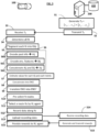
- the vehicle data recording device 140 executes a task of path planning for the vehicle 100.
- the path planning operation includes the steps S4 to S11 described below, carried out by the path planning module 143.
- the steps S4 to S11 will be described for one vehicle 100, but can be performed by each of the recording vehicles 100 after reception of the recording target To.
- the route encoder 144 first computes route encodings for a plurality of routes Ri, in the steps S4 to S9. As previously explained, a route encoding for a given route Ri encodes into numerical values an information on predicted values of said route Ri for a plurality of metrics ⁇ c k .
- the car navigation system 1440 determines a plurality of routes Ri that the vehicle 100 can take.
- the determination of the routes Ri is performed by execution of a tree expansion algorithm.
- the tree root can advantageously be the current location of the vehicle 100.
- the car navigation system explores all the routes that can be taken and builds a tree of possible routes Ri for the vehicle 100. Every branch of the tree represents a specific route Ri.
- the algorithm stops the tree expansion based on a given stop criteria (for example a distance, an estimated driving time, or any other appropriate criteria).
- the segmentation block 1441 divides each route Ri determined in the step S4 into route segments RSij.
- the segment breakdown of the routes Ri is performed by following predefined semantic boundaries like crossings, environmental features, distance, time, navigation system level or a combination thereof. Such a segmentation allows to encode the features of the routes Ri on a finer level.
- the feature encoder 1442 generates a feature vector Vij for each route segment RSij of each route Ri.
- each route segment RSij is described into a feature vector Vij.
- the feature vector can also be regarded as a feature point in a multi-dimensional space in which each dimension corresponds to a given feature class or category for describing the route Ri.
- the feature vector Vij of a route segment RSij is a kind of representation (in other words: a description) in numerical values of what might be observed along the route segment RSij.
- the step S6 includes three sub-steps S60 to S62, described below.
- the feature encoder 1442 encodes into numerical values past information on what happened to the recording vehicle 100 just before the current time t 0 , so as to form a first component Aij of the feature vector Vij. Indeed, at time t 0 , the data recording device 140 has already recorded past data from the vehicle 100 during the last few minutes and consequently knows about the past.
- the past information can include a summary of recording data collected by the in-vehicle data recording device 140 during the past period of time leading up to the current time to.
- the recording data can include at least part of the following information:
- the purpose of encoding past recording data collected just before the current point in time to (or a summary of the past recording data) is to capture specific conditions and/or environmental features related to the current period of time, like information on the weather, the type of route driven by the vehicle 100, the number of pedestrians in the street, or any other relevant past information recently detected up, that might influence predictions or estimations of the value estimator 1443 about the near future for the routes Ri.
- the recording data collected during the past period of time leading up to time t 0 can be aggregated, for example by adding some values, to obtain a summary of the recording data and limit the quantity of data in the component Aij of the vector Vij.
- the information about the past encoded in the first component Aij of the vector Vij can be very informative for the machine learning system (value estimator) 1443. For example, let's consider that, at time t 0 , it is night and rainy and the vehicle 100 drives in a city, in the vicinity of shops. Usually, there are lots of pedestrians in the city near shops. But, as the machine learning module 1443 knows from the last few minutes that it is raining and it is night, it might not expect so many pedestrians.
- the piece of information that has been encoded in the component Aij of the feature vector Vij, coming from the summary of what has happened in the last few minutes is used by the machine learning model 1443 to better evaluate the value of the segment for the metric associated with pedestrians.
- the feature encoder 1442 encodes into numerical values environmental features related to the route segment RSij and relevant for the metrics ⁇ c k , in order to form a second component Bij of the vector Vij.
- the encoded environmental features of the route segment RSij include any type of feature that might be relevant for the metrics (in other words: any type of feature that may be correlated with the metrics).
- the environmental feature includes at least part of the environmental information previously described. It can include a type of the environment (e.g., urban, highway, countryside, other), a number of shops in the vicinity, the presence of a school in the vicinity, crossings, weather information (for example from a weather forecast service, or present weather), etc.
- a metric that is a function that determines a number of pedestrians in the surroundings.
- the features like the number of shops in the vicinity, the presence of a school in the vicinity, and any other segment feature that might be correlated with the presence of pedestrians can be encoded in the second component Bij of the vector Vij.
- first component Aij and the second component Bij are concatenated to form the feature vector Vij of the route segment RSij, in a step S62.
- the value estimator 1443 can include a machine learning system trained to evaluate the respective values of a route segment RSij, described by a feature vector, for a plurality of predefined metrics ⁇ c k (in other words: for a given set of metrics ⁇ c k ).
- the metrics ⁇ c k for which the value estimator 1443 performs a value estimation typically include not only the metrics of the recording target but also other metrics.
- the value estimator 1443 outputs for each route segment RSij a metric value prediction vector including predicted values of the route segment RSij for the plurality of predefined metrics ⁇ c k .
- the predicted values are advantageously normalized over the segment distance to obtain data value densities.
- the value estimator 1443 can also output an uncertainty information on the predicted values.
- the uncertainty information can include uncertainties of the predicted values for all metrics.
- the data value densities (and optionally the uncertainty information) of all the route segments RSij of each route Ri are concatenated by the concatenator 1444 to form a high-dimensional route encoding ENCi of each route Ri, in the step S8.
- the route encoding ENCi of each route Ri has a lot of dimensions because it includes, for each segment RSij of the route Ri, the predicted values for the predefined metrics ⁇ c k and the corresponding uncertainties.
- the routes Ri may have different numbers of route segments RSij, the sizes of the route encodings ENCi may be different from each other.
- the high-dimensional route encoding ENCi is translated (in other words: converted) by the translator 1445 into a fixed-length route encoding ENCi' of lower dimension.
- the translator 1445 breaks down the high-dimensional route encoding ENCi of each route Ri into a denser encoding ENCi', so as to form a fixed-length description of the overall route Ri in a normalized way. This allows to transform the encoding of each route Ri into an encoding that can be used by the reinforcement learning agent 146 for selecting a route.
- the length of the route encodings ENCi' corresponds to the fixed input dimensionality of the reinforcement learning agent 146.
- the encoding translation aggregates segments to form a route encoding composed of three parts: a short-term part, a mid-term part and a long-term part, that correspond respectively to three intervals of distance from the current position of the vehicle 100 (short, mid and long).
- short-term can corresponds to a distance of approximately 100 m
- mid-term to a distance of approximately 1000 m
- long-term to a distance of more than 1000 m, for example.
- any other distance values could be used.
- Any other aggregation of the route encodings ENCi could be used, in order to find a suitable representation for the reinforcement learning agent.
- the route pre-selector 145 pre-selects a subset of candidate routes.
- the forming of the route encodings into a normalized representation can integrate the expected rewards and the route features for short, mid and long-term scenarios. Therefore, the pre-selector 145 can use the normalized route encodings to pick the candidate routes. For example, the pre-selector 145 can just select the most valuable routes. Alternatively, the best candidate route(s) for every recording target could be selected. The uncertainty of the predicted recording values might influence the pre-selected candidates. As an illustrative and non-limitative example, only the five most promising routes Ri can be selected.
- the fixed-length route encodings ENCi' of the routes Ri pre-selected in the step S10 (or of all the routes Ri if step S10 is not performed) and an additional environmental information, that is independent of the routes Ri, are provided as inputs to the reinforcement learning agent, or route selector 146.
- the additional environmental information is information that is independent of the features encoded to generate the feature vectors Vij of the route segments RSij.
- it can include an information on the 5G bandwidth availability as determined by the vehicle 100, an information on the remaining gas in the vehicle 100, an information on a remaining recording time (e.g., given by the driver), an information on a recording buffer state (i.e., remaining recording space in buffer), or any other information that is independent of (different from) the route features encoded and is relevant for selecting a route to be taken by the vehicle 100 to record data and upload recording data to the host data collecting system 200.
- a remaining recording time e.g., given by the driver
- an information on a recording buffer state i.e., remaining recording space in buffer
- the reinforcement learning agent 146 uses the fixed-length route encodings ENCi' and the additional environmental information, as inputs, to select, among the pre-selected routes Ri, the route Rs that is expected to maximize or optimize the rewards from the host data collecting system 200 in return to uploading recording data collected along said selected route Rs, for the recording target To received as input.
- the reinforcement learning agent has the option to stay on the current route. In other words, the reinforcement learning agent can chose to either stay on the current route, or switch to one of the proposed new routes.
- the path planning module provides the selected route Rs to the vehicle 100 through the interface 141, when the reinforcement learning agent has decided to change the current route.
- the vehicle 100 drive long the selected route Rs and the data recording device 140 records data along the route Rs in a step S12.
- the recording data is received from the vehicle 100 and can include different types such as raw data, derived data and/or external data.
- the recording data collected (recorded) in the step S12 is transmitted to the host data collecting system 200.
- the recording data is uploaded. If only bad data (of low value) is recorded, it can be decided not to upload the recording data collected.
- the host data collecting system 200 receives the successfully uploaded recording data from the recording vehicle 100.
- the host data collecting system 200 stores the received recording data into a storing infrastructure 400.
- the host data collecting system 200 generates a reward information in return to a successful upload of recording data from the vehicle 100 and transmits the reward information to the vehicle 100 (more precisely to the data recording device 140).
- the reward information can include different types of rewards to reward different types of actions such as the continuous action of uploading recording data, the action of uploading entirely and successfully the recording, the action of recording and uploading pieces of recording data of high value for the recording target T 0 , etc...
- the vehicle data recording device 140 receives the reward information (here via the transmitter-receiver 120 of the vehicle 100) and provides it to the reinforcement learning agent 146 to improve the selection of routes.
- the rewards don't need to be given by the host data collecting system 200. It would be enough to simulate the reward behaviour in the vehicle 100, after successful upload.
- the machine learning system 1443 is trained in a preliminary step by using historical (past) recording data collected by recording vehicles driving along routes.
- the historical recording data related to a plurality of recordings performed in the past by one or more recording vehicles driving along different routes. Training data are generated from the historical data.
- each route driven in the past is divided into segments (as in the step S5), the feature vector of each route segment is generated (as in the step S6), and the values of each route segment for the plurality of predefined metrics ⁇ c k are computed by using the historical recording data.
- the dataset of training data includes the feature vectors of all the route segments derived from the routes driven in the past, as input training data, and the corresponding segment aggregated average values of the metrics ⁇ c k , as output training data.
- the dataset of training data is provided to the machine learning system 1443 to train it to compute the computed values related to the plurality of metrics for the corresponding route segments.
- the machine learning system 1443 once trained allows to estimate (predict) a recording value density for each route segment for every metric.
- the machine learning system 1443 can be an aggregated model that is in charge of computing all the metrics ⁇ c k for each route segment. Alternatively, the machine learning system 1443 includes N models to compute the respective N metrics.
- the reinforcement learning agent of the route selector 146 is trained to decide which one of a plurality of proposed routes should be picked.
- the training of the reinforcement learning agent of the route selector 146 can use data as previously described.
- the input training data for the reinforcement learning agent includes route encodings, preferably normalized route encodings, determined based on the simulated data, and the output training data includes scores or numeric values indicating how much the reinforcement learning agent would like to pick a specific route proposal from presented candidate routes.
Priority Applications (3)
| Application Number | Priority Date | Filing Date | Title |
|---|---|---|---|
| EP21191928.7A EP4138057A1 (fr) | 2021-08-18 | 2021-08-18 | Procédé de sélection d'itinéraire pour véhicule de mesure |
| CN202210953432.9A CN115707610A (zh) | 2021-08-18 | 2022-08-10 | 选择用于记录载具的路线的方法 |
| US17/820,814 US20230055974A1 (en) | 2021-08-18 | 2022-08-18 | Method of Selecting a Route for Recording Vehicle |
Applications Claiming Priority (1)
| Application Number | Priority Date | Filing Date | Title |
|---|---|---|---|
| EP21191928.7A EP4138057A1 (fr) | 2021-08-18 | 2021-08-18 | Procédé de sélection d'itinéraire pour véhicule de mesure |
Publications (1)
| Publication Number | Publication Date |
|---|---|
| EP4138057A1 true EP4138057A1 (fr) | 2023-02-22 |
Family
ID=77518926
Family Applications (1)
| Application Number | Title | Priority Date | Filing Date |
|---|---|---|---|
| EP21191928.7A Pending EP4138057A1 (fr) | 2021-08-18 | 2021-08-18 | Procédé de sélection d'itinéraire pour véhicule de mesure |
Country Status (3)
| Country | Link |
|---|---|
| US (1) | US20230055974A1 (fr) |
| EP (1) | EP4138057A1 (fr) |
| CN (1) | CN115707610A (fr) |
Citations (6)
| Publication number | Priority date | Publication date | Assignee | Title |
|---|---|---|---|---|
| US6073063A (en) | 1997-02-06 | 2000-06-06 | Ford Global Technologies, Inc. | Automotive data recording device |
| US10295363B1 (en) * | 2016-01-22 | 2019-05-21 | State Farm Mutual Automobile Insurance Company | Autonomous operation suitability assessment and mapping |
| US20200292343A1 (en) * | 2018-09-30 | 2020-09-17 | Strong Force Intellectual Capital, Llc | Method of optimizing rider satisfaction |
| KR102164509B1 (ko) * | 2019-12-11 | 2020-10-12 | 김용걸 | 인공지능을 이용한 IoT 기반 쓰레기 수거차량 최적화 경로 제공시스템 |
| US20200363813A1 (en) * | 2019-05-15 | 2020-11-19 | Baidu Usa Llc | Online agent using reinforcement learning to plan an open space trajectory for autonomous vehicles |
| US20200377090A1 (en) * | 2019-05-29 | 2020-12-03 | Hyundai-Aptiv Ad Llc | Estimating speed profiles |
-
2021
- 2021-08-18 EP EP21191928.7A patent/EP4138057A1/fr active Pending
-
2022
- 2022-08-10 CN CN202210953432.9A patent/CN115707610A/zh active Pending
- 2022-08-18 US US17/820,814 patent/US20230055974A1/en active Pending
Patent Citations (6)
| Publication number | Priority date | Publication date | Assignee | Title |
|---|---|---|---|---|
| US6073063A (en) | 1997-02-06 | 2000-06-06 | Ford Global Technologies, Inc. | Automotive data recording device |
| US10295363B1 (en) * | 2016-01-22 | 2019-05-21 | State Farm Mutual Automobile Insurance Company | Autonomous operation suitability assessment and mapping |
| US20200292343A1 (en) * | 2018-09-30 | 2020-09-17 | Strong Force Intellectual Capital, Llc | Method of optimizing rider satisfaction |
| US20200363813A1 (en) * | 2019-05-15 | 2020-11-19 | Baidu Usa Llc | Online agent using reinforcement learning to plan an open space trajectory for autonomous vehicles |
| US20200377090A1 (en) * | 2019-05-29 | 2020-12-03 | Hyundai-Aptiv Ad Llc | Estimating speed profiles |
| KR102164509B1 (ko) * | 2019-12-11 | 2020-10-12 | 김용걸 | 인공지능을 이용한 IoT 기반 쓰레기 수거차량 최적화 경로 제공시스템 |
Also Published As
| Publication number | Publication date |
|---|---|
| CN115707610A (zh) | 2023-02-21 |
| US20230055974A1 (en) | 2023-02-23 |
Similar Documents
| Publication | Publication Date | Title |
|---|---|---|
| RU2683902C2 (ru) | Транспортное средство, способ и система для планирования режимов транспортного средства с использованием изученных предпочтений пользователя | |
| US11257377B1 (en) | System for identifying high risk parking lots | |
| CN109919347B (zh) | 路况生成方法、相关装置和设备 | |
| US9868393B2 (en) | Vehicle accident avoidance system | |
| US10883850B2 (en) | Additional security information for navigation systems | |
| JP5013211B2 (ja) | 運転評価システム及び運転評価プログラム | |
| US7706964B2 (en) | Inferring road speeds for context-sensitive routing | |
| CN114973677A (zh) | 用于确定预计到达时间的方法和设备 | |
| US20210191394A1 (en) | Systems and methods for presenting curated autonomy-system information of a vehicle | |
| EP4138051A1 (fr) | Procédé de collecte de données à partir d'une flotte de véhicules | |
| JP2011503639A (ja) | 地図の更新において使用される、実世界の変化を検出するために複数の車両からのプローブ・データを使用する方法及びシステム | |
| US10745010B2 (en) | Detecting anomalous vehicle behavior through automatic voting | |
| US20230154332A1 (en) | Predicting traffic violation hotspots using map features and sensors data | |
| US11668580B2 (en) | System and method of creating custom dynamic neighborhoods for individual drivers | |
| US11430330B2 (en) | Method for predicting travel time using spatio-temporal model and apparatus thereof | |
| WO2020164089A1 (fr) | Prédiction de trajectoire utilisant une fusion de prédicteurs multiples à apprentissage profond et une optimisation bayésienne | |
| CN114004077A (zh) | 交通仿真转换方法、装置、计算机设备及存储介质 | |
| EP4138057A1 (fr) | Procédé de sélection d'itinéraire pour véhicule de mesure | |
| EP4270352A1 (fr) | Contrôle d'un état futur de trafic sur un segment de route | |
| JP2023005015A (ja) | 交通状況予測装置、および、交通状況予測方法 | |
| JP2023092971A (ja) | 交通状況予測装置、および、交通状況予測方法 | |
| CN106781470B (zh) | 城市道路的运行速度的处理方法及装置 | |
| CN112710316A (zh) | 专注于构造和本地化技术领域的动态地图生成 | |
| US11852495B1 (en) | Computational model for creating personalized routes based at least in part upon predicted total cost of claim frequency or severity | |
| US20240085193A1 (en) | Automated dynamic routing unit and method thereof |
Legal Events
| Date | Code | Title | Description |
|---|---|---|---|
| PUAI | Public reference made under article 153(3) epc to a published international application that has entered the european phase |
Free format text: ORIGINAL CODE: 0009012 |
|
| STAA | Information on the status of an ep patent application or granted ep patent |
Free format text: STATUS: THE APPLICATION HAS BEEN PUBLISHED |
|
| AK | Designated contracting states |
Kind code of ref document: A1 Designated state(s): AL AT BE BG CH CY CZ DE DK EE ES FI FR GB GR HR HU IE IS IT LI LT LU LV MC MK MT NL NO PL PT RO RS SE SI SK SM TR |
|
| RAP3 | Party data changed (applicant data changed or rights of an application transferred) |
Owner name: APTIV TECHNOLOGIES LIMITED |
|
| STAA | Information on the status of an ep patent application or granted ep patent |
Free format text: STATUS: REQUEST FOR EXAMINATION WAS MADE |
|
| 17P | Request for examination filed |
Effective date: 20230627 |
|
| RBV | Designated contracting states (corrected) |
Designated state(s): AL AT BE BG CH CY CZ DE DK EE ES FI FR GB GR HR HU IE IS IT LI LT LU LV MC MK MT NL NO PL PT RO RS SE SI SK SM TR |
|
| RAP1 | Party data changed (applicant data changed or rights of an application transferred) |
Owner name: APTIV TECHNOLOGIES AG |