EP4081998B1 - Bodenkollisionswarnsystem für flughafen - Google Patents
Bodenkollisionswarnsystem für flughafen Download PDFInfo
- Publication number
- EP4081998B1 EP4081998B1 EP19957614.1A EP19957614A EP4081998B1 EP 4081998 B1 EP4081998 B1 EP 4081998B1 EP 19957614 A EP19957614 A EP 19957614A EP 4081998 B1 EP4081998 B1 EP 4081998B1
- Authority
- EP
- European Patent Office
- Prior art keywords
- aircraft
- airport
- ads
- ground collision
- alerting system
- Prior art date
- Legal status (The legal status is an assumption and is not a legal conclusion. Google has not performed a legal analysis and makes no representation as to the accuracy of the status listed.)
- Active
Links
Images


Classifications
-
- G—PHYSICS
- G08—SIGNALLING
- G08G—TRAFFIC CONTROL SYSTEMS
- G08G5/00—Traffic control systems for aircraft
- G08G5/80—Anti-collision systems
-
- G—PHYSICS
- G08—SIGNALLING
- G08G—TRAFFIC CONTROL SYSTEMS
- G08G5/00—Traffic control systems for aircraft
- G08G5/20—Arrangements for acquiring, generating, sharing or displaying traffic information
- G08G5/21—Arrangements for acquiring, generating, sharing or displaying traffic information located onboard the aircraft
-
- G—PHYSICS
- G08—SIGNALLING
- G08G—TRAFFIC CONTROL SYSTEMS
- G08G5/00—Traffic control systems for aircraft
- G08G5/20—Arrangements for acquiring, generating, sharing or displaying traffic information
- G08G5/25—Transmission of traffic-related information between aircraft
-
- G—PHYSICS
- G08—SIGNALLING
- G08G—TRAFFIC CONTROL SYSTEMS
- G08G5/00—Traffic control systems for aircraft
- G08G5/20—Arrangements for acquiring, generating, sharing or displaying traffic information
- G08G5/26—Transmission of traffic-related information between aircraft and ground stations
-
- G—PHYSICS
- G08—SIGNALLING
- G08G—TRAFFIC CONTROL SYSTEMS
- G08G5/00—Traffic control systems for aircraft
- G08G5/50—Navigation or guidance aids
- G08G5/51—Navigation or guidance aids for control when on the ground, e.g. taxiing or rolling
-
- G—PHYSICS
- G08—SIGNALLING
- G08G—TRAFFIC CONTROL SYSTEMS
- G08G5/00—Traffic control systems for aircraft
- G08G5/70—Arrangements for monitoring traffic-related situations or conditions
- G08G5/72—Arrangements for monitoring traffic-related situations or conditions for monitoring traffic
- G08G5/723—Arrangements for monitoring traffic-related situations or conditions for monitoring traffic from the aircraft
Definitions
- the present invention relates broadly to an airport ground collision alerting system (AGCAS) and to a method of operating an AGCAS.
- AGCAS airport ground collision alerting system
- US 7,630,829 B2 describes a system, which combines the present and estimated future positions of the ownship with that of approaching aircraft and/or airfield structure data, and creates an alert to the crew if a threat of a ground incursion is detected.
- the ownship position is determined from an integration with the ownship on-board navigation system, which has been recognized by the inventors to be technically complex and typically requiring a supplemental type certificate (STC) to operate such a system on an aircraft, increasing costs of installation.
- STC supplemental type certificate
- a stand-alone system is also described in which the ownship position is determined based on a separate GPS module incorporated in the stand-alone system.
- the operation of a separate GPS module in a cockpit environment may provide unreliable data due to shielding/interference from other aircraft systems and structures.
- A-SMGCS Advanced Surface Movement Guidance & Control System
- AVOL aerodrome visibility operational level
- IOU definition the required level of safety.
- A-SMGCS does not provide collision warning for individual aircraft; traditionally, it is the individual aircrews' responsibility to maintain safe separation of their own aircraft from obstacles.
- EP 2 892 041 A1 describes a ground obstacle detection system of an aircraft configured to generate and display a graphical user interface (GUI) that includes a graphical representation of a detected obstacle with which the aircraft may collide during a ground operation and an indication of an area of unknown associated with the detected obstacle.
- GUI graphical user interface
- Embodiments of the present invention seek to address at least one of the above problems.
- an airport ground collision alerting system as defined in claim 1.
- Embodiments of the present invention aim to provide aircrews and ground crews with situational awareness, by displaying the position of their own aircraft relative to surrounding obstacles, and providing visual/aural warnings when their aircraft is about to hit these obstacles, in order for the crews to take appropriate avoiding action.
- the airport ground collision alerting system is a predictive warning system intended to provide visual/aural alerts to aircrews and ground crews when their aircraft is in proximity to obstacles (other aircraft, airport fixed structures) and at risk of hitting them, in order for the crews to take appropriate avoiding action.
- FIG. 1 shows a schematic block diagram of an AGCAS 100 according to an example embodiment.
- the AGCAS 100 comprises: An ADS-B receiver 102.
- Automatic Dependent Surveillance-Broadcast (ADS-B) is an international surveillance system now standard on all commercial aircraft.
- the ADS-B system reports an aircraft's identity, type, location, altitude, velocity and heading to air traffic control and other aircraft. It has been recognized by the inventors that ADS-B receiver 102, in addition to providing information on other aircraft in the vicinity of the ownship, can advantageously be used to also determine information about the ownship itself, which is reported by the ownship under the ADS-B standard.
- the inventors have also recognized that the ADS-B information has superior reliability compared to determining the ownship information such as location, altitude, velocity from a dedicated GPS module in a cockpit environment, due to shielding/interference from other aircraft systems and structures.
- the data received by the ADS-B receiver 102 is provided to an aircraft database 103 of the AGCAS 100.
- the aircraft database 103 stores/updates the information about the ownship and other aircraft, such as e.g. ID, position, type and heading.
- the aircraft database 103 enables the look up of the aircraft ID code into the aircraft type, dimensions and other aircraft specific information, which will be used by the collision detection algorithm, as will be described in more detail below.
- the AGCAS 100 optionally also comprises a GPS receiver 104 housed into the AGCAS 100. This can provide back-up or redundant determination for the ownship location, for example if there is a failure of the on-board ADS-B transmitter system (not shown) and/or the ADS-B receiver 102.
- the AGCAS 100 optionally also comprises an inertial measurement unit (IMU) 106, housed into the AGCAS 100.
- IMU inertial measurement unit
- the IMU 106 can provide back-up or redundant determination of the orientation of the aircraft and can advantageously also be used for smoothing the output from the GPS receiver 104 based on the aircraft movement.
- the AGCAS 100 also comprises an airport and obstacle database 107 for storing digital airport maps, which contain all fixed obstacles in the airport that pose a collision risk to aircraft, e.g. buildings, light towers, jet blast deflector etc.
- the airport and obstacles database 107 will contain maps of all major international airports.
- the maps can be developed from satellite imagery and aerodrome charts, as will be appreciated by a person skilled in the art.
- the AGCS 100 also comprises a processor/computing unit 108 with a software application installed thereon, running a collision detection algorithm.
- the algorithm continuously compares its own aircraft location against other aircraft locations and airport obstacles and generates warnings when there is a potential collision.
- two main functions performed by the algorithm have been indicated by boxes 110 and 112, namely ownship location and safety bubble calculation (box 110), and collision prediction (box 112).
- the AGCAS 100 may comprise a built-in battery (not shown) and/or may be configured for powering from power outlets that may be available on-board in the cockpit.
- An electronic display device 114 is coupled to the AGCAS 100, which may be a tablet or a laptop, to display the relevant airport map and system advisories.
- the electronic display device 114 is coupled wirelessly to the AGCAS 100 in this embodiment, but may be coupled via wire in different embodiments. It is noted that the electronic display device 114 is preferably provided by the user/customer and hence not part of the AGCAS 100, as cockpit tablet and/or laptops are now widely used by most airlines. However, the electronic display device 114 may be provided as part of the AGCAS 100 in different embodiments, either physically integrated with, or separate from, the AGCAS 100 housing.
- the AGCAS 100 provides a system and/or method for avoiding airport ground collisions.
- the AGCAS 100 can be installed in the aircraft cockpit.
- the ADS-B receiver 102 collects various information regarding the ownship as well as other aircraft, the information including, for example, aircraft ID code, callsign, location, velocity, heading, altitude etc.
- the aircraft database 103 enables the look up of the obtained aircraft ID code(s) into the aircraft type, dimensions and other aircraft specific information for the ownship and other aircraft, which will be used by the collision detection algorithm and is provided to the processor/computing unit 108 by the aircraft database 103.
- the collision detection algorithm running on the processor/computing unit 108 continuously compares the ownship location and a calculated safety bubble around the ownship (compare box 110) against other aircraft locations and airport obstacles provided to the processor/computing unit 108 by the airport and obstacle database 107, to perform collision prediction (compare box 112).
- the collision detection algorithm running on the processor/computing unit 108 generates warnings, which are sent to the electronic display device 114 when there is a potential collision.
- the electronic display device 114 used by the pilots is loaded with a proprietary software and/or algorithms including a map engine 116 for the display of the ownship's current position, indicated by a symbol such as a schematic image of an aircraft, dynamically within the relevant airport map, and for the drawing and displaying of a safety bubble around the ownship's location as a visual aid, according to the size and dimensions of the aircraft.
- the proprietary software and/or algorithm also includes a graphical user interface (GUI) application 117, configured to enable visual and/or aural warnings to a user via the electronic display device 114.
- the map information from the airport and obstacles database 107 may be provided to the electronic display device 114 via an electronic display interface/application programming interface (API) 115.
- API electronic display interface/application programming interface
- the electronic display device may be loaded with its own airport and obstacles database 119.
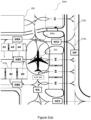
- the safety bubble 200a, 200b is drawn to envelope the aircraft, represented by symbol 202, and may change in colour in order to provide visual warning to the user in case of an impending collision.
- the safety bubble 200a, 200b and/or the symbol 202 will move and rotate according to the aircraft orientation.
- the safety bubble 200a, 200b also grows longitudinally in proportion to the aircraft's direction of travel and velocity on the map 204a, 204b. For example, in a forward movement scenario, the safety bubble 200a, 200b will be elongated in a forward direction away from the cockpit to account for aircrew reaction/aircraft braking time in trying to avoid a potential collision. The amount of the elongation will be proportional to the current speed of the aircraft.
- the safety bubble 200a, 220b and symbol 202 are overlaid on the digital map 204a, 204b of the airport, with the map 204a, 204b containing information about stationery obstacles such as buildings e.g. 206 and the safety bubbles e.g. 208 of other aircraft calculated and displayed in the same fashion as for the ownship.
- Moving aircraft (not shown) in the vicinity of the ownship will be displayed with a corresponding moving safety bubble, which may also grow longitudinally in proportion to the aircraft's direction of travel and velocity on the map 204a, 204b.
- the map 204a, 204b of the airport advantageously also contains airport features to give the pilots a better situational awareness, including buildings e.g. 206, runways, taxiways e.g. 210a, 210b, parking bays e.g. 212a, 212b and markings e.g. 214a, 214b on the tarmac.
- the electronic display device 114 will receive collision warnings from the AGCAS 100 (see Figure 1 ), specifically from an electronic display interface/application programming interface (API) 115 (see Figure 1 ) and will visually and audibly alert the pilots if there is potential danger of collision.
- This can take the form of an aural voice message and/or visual warnings such as change in the safety bubble 200a, 200b display color and/or a flashing visual warning on the electronic display device 114 (see Figure 1 ).
- the GPS receiver104 collects back-up or redundant information about the ownship position, while the IMU 106 (see Figure 1 ) is optionally used to provide the orientation of the aircraft and to smoothen the output from the GPS receiver 104 (see Figure 1 ).
- Swept wing aircraft experience a phenomenon known as "wing growth" when they turn.
- a swept wing is a wing that angles backward (most common, but occasionally forward) from its root at the aircraft's fuselage. Because the main wheels of the aircraft are typically located at or close to the root of the wings at the fuselage, when the aircraft is turning the tip of the wing facing away from the centre of the turn moves on a trajectory that goes beyond the wingspan-based distance from the fuselage prior to turning. For example, as the aircraft turns left, the tip of the right wing will move rightwards relative to its original position during the initial stages of the turn. Accordingly, the safety bubble (compare 200a, 200b in Figure 2 ) is expanded at the relevant tip area of the swept wing when a turn is detected.
- the wing growth advisory function of an AGCAS advantageously provides a warning when it is detected that the aircraft is turning by detecting heading changes based on the ADS-B data (or the GPS data in back-up/redundant mode) and will expand the safety bubble laterally in size to depict the relative wing growth of the outboard wing span, to visualize the longest distance from the apex of the turn.
- the AGCAS according to such an embodiment will issue a warning when there is an imminent collision with an obstacle by the expanded safety bubble and this will be indicated on the display.
- the software application installed on the processor/computing unit advantageously provides a de-clutter mode to disregard ADS-B signals of aircraft that are not near (as compared to a threshold distance, which may be preinstalled and/or user selectable), and do not pose a collision risk to the ownship. These aircraft will be suppressed from display on the electronic display (compare 114 in Figure 1 ), making it easier for the crew to focus on the more relevant information displayed.
- the AGCAS relies on aircraft transmitting their presence and location via ADS-B in order to be detectable, or fixed airport obstacles to be recorded in the airport map. Once an aircraft has parked and powers down, the ADS-B signal will be lost and the aircraft is no longer detectable.
- a non-transmitting aircraft functionality feature can be provided in the AGCAS according to an example embodiment, in the form of a temporary aircraft database.
- its associated AGCAS Prior to an aircraft shutting down, its associated AGCAS according to such an example embodiment will record and remember the last position of the aircraft.
- the temporary aircraft database is not resident in the AGCAS located on board the aircraft. Instead, the temporary aircraft database is remotely located, e.g. in a cloud server (compare 118 in Figure 1 ).
- a cloud server compute 118 in Figure 1 .
- the AGCAS When a user starts up their AGCAS according to such an example embodiment and loads the map for an airport, the AGCAS will connect to the temporary aircraft database, e.g. the cloud server (compare 118 in Figure 1 ), and retrieve the last recorded position of non-transmitting aircraft that are located at the relevant airport, and thus will advantageously be able to indicate the location of a parked aircraft, even though the aircraft is shut down and not transmitting its position.
- the temporary aircraft database e.g. the cloud server (compare 118 in Figure 1 )
- parked aircraft may be relocated from one position to another for various reasons, and the temporary aircraft database preferably keeps track of these movements, in order to remain current and not lose its relevance.
- This update can for example be achieved in two ways according to example embodiments:
- aircraft that are classified as ICAO Code F aircraft may encounter some areas in an airport which cannot accommodate their large wingspan.
- the airport map engine (compare 116 in Figure 1 ) will cause the display to indicate an visual sign such as an 'X' on the relevant area of the map display, warning the crew not to enter this area/taxiway. For smaller aircraft, this restriction will not be displayed.
- the AGCAS can comprise a software for monitoring relevant NOTAMs (Notice to Airmen) information and mines out the relevant information related to airfield conditions and updates them on the map.
- the software can be installed and run on the processor/computing unit (compare 108 in Figure 1 ). It is noted that the AGCAS according to example embodiments may not itself “receive” the NOTAM, but it "learns" about the NOTAMs by uploading updated maps (compare airport database 107 in Figure 1 ) that have incorporated NOTAM advisories.
- the update to the map is performed offline with respect to the AGCAS according to such example embodiments, by a server that houses all the airport maps.
- the AGCAS runs a computer algorithm to intelligently mine NOTAMs online, filter out all non-applicable NOTAMs, i.e. identifying only those affecting the relevant airport surface operations, and further identifying which of those NOTAMs affect runway/taxiway/apron operations.
- the digital airport map engine (compare 116 in Figure 1 ) preferably enables layered control/display of the digital airport maps.
- the digital maps consists of layers in such example embodiments, it is possible to have a layer to display current airport status information, such as closure of a particular taxiway.
- the AGCAS loads and displays an airport map, it will also indicate that a particular runway is closed to aircraft traffic, as per the mined NOTAMs.
- A-SMGCS Advanced Surface Movement Guidance & Control System
- AVOL aerodrome visibility operational level
- IOU definition the required level of safety.
- A-SMGCS does not provide collision warning for individual aircraft; traditionally, it is the individual aircrews' responsibility to maintain safe separation of their own aircraft from obstacles.
- the AGCAS master display version allows ATC controllers to have additional situational awareness, and enabling them to warn aircrews of impending collisions. Practically, this will likely entail a policy/procedural change for ATC, as it means ground controllers would be assuming responsibility for collision avoidance, when it is traditionally the aircrews' responsibility as previously mentioned.
- Figure 3 shows a flowchart 300 illustrating a method of operating an airport ground collision alerting system according to the invention.
- Computer-readable media in which such formatted data and/or instructions may be embodied include, but are not limited to, non-volatile storage media in various forms (e.g., optical, magnetic or semiconductor storage media) and carrier waves that may be used to transfer such formatted data and/or instructions through wireless, optical, or wired signaling media or any combination thereof.
- Examples of transfers of such formatted data and/or instructions by carrier waves include, but are not limited to, transfers (uploads, downloads, e-mail, etc.) over the internet and/or other computer networks via one or more data transfer protocols (e.g., HTTP, FTP, SMTP, etc.).
- data transfer protocols e.g., HTTP, FTP, SMTP, etc.
- a processing entity e.g., one or more processors
- aspects of the systems and methods according to example embodiments described herein may be implemented as functionality programmed into any of a variety of circuitry, including programmable logic devices (PLDs), such as field programmable gate arrays (FPGAs), programmable array logic (PAL) devices, electrically programmable logic and memory devices and standard cell-based devices, as well as application specific integrated circuits (ASICs).
- PLDs programmable logic devices
- FPGAs field programmable gate arrays
- PAL programmable array logic
- ASICs application specific integrated circuits
- microcontrollers with memory such as electronically erasable programmable read only memory (EEPROM)
- embedded microprocessors firmware, software, etc.
- aspects of the system may be embodied in microprocessors having software-based circuit emulation, discrete logic (sequential and combinatorial), custom devices, fuzzy (neural) logic, quantum devices, and hybrids of any of the above device types.
- the underlying device technologies may be provided in a variety of component types, e.g., metal-oxide semiconductor field-effect transistor (MOSFET) technologies like complementary metal-oxide semiconductor (CMOS), bipolar technologies like emitter-coupled logic (ECL), polymer technologies (e.g., silicon-conjugated polymer and metal-conjugated polymer-metal structures), mixed analog and digital, etc.
- MOSFET metal-oxide semiconductor field-effect transistor
- CMOS complementary metal-oxide semiconductor
- bipolar technologies like emitter-coupled logic (ECL)
- polymer technologies e.g., silicon-conjugated polymer and metal-conjugated polymer-metal structures
- mixed analog and digital etc.
Landscapes
- Engineering & Computer Science (AREA)
- Aviation & Aerospace Engineering (AREA)
- Physics & Mathematics (AREA)
- General Physics & Mathematics (AREA)
- Radar, Positioning & Navigation (AREA)
- Remote Sensing (AREA)
- Traffic Control Systems (AREA)
Claims (15)
- Eine bordeigene Flughafen-Bodenkollisionswarnvorrichtung (100) zur Verwendung an Bord eines Flugzeugs, wobei die Flughafen-Bodenkollisionswarnvorrichtung (100) aufweist:einen automatischen, abhängigen Überwachungsübertragung (ADS-B) Empfänger (102);eine erste Datenbank (103), die mit dem ADS-B-Empfänger (102) verbunden ist und zum Abrufen von Flugzeugtypdaten basierend auf den über den ADS-B-Empfänger (102) empfangenen Flugzeug-ID-Daten und zum Speichern von über den ADS-B-Empfänger (102) empfangenen Flugzeugpositions- und -kursdaten konfiguriert ist;eine zweite Datenbank (107), die zum Speichern digitaler Kartendaten für einen oder mehrere Flughäfen konfiguriert ist;Eine Prozessoreinheit (108), die mit der ersten und zweiten Datenbank (103, 107) verbunden ist und konfiguriert ist, um:Position und Kurs des Flugzeugs, an Bord dessen die Flughafen-Bodenkollisionswarnvorrichtung benutzt wird, anhand der in der ersten Datenbank (103) gespeicherten Positions- und Kursdaten des Flugzeugs zu bestimmen, die von einem bordeigenen ADS-B-Sender (102) des Flugzeugs über den ADS-B-Empfänger (102) in einer ADS-B-Übertragung empfangen werden, wobei sich der bordeigene ADS-B-Sender (102) außerhalb der bordeigenen Flughafen-Bodenkollisionswarnvorrichtung befindet;die jeweiligen Positionen und Kurse eines oder mehrerer anderer Flugzeuge an einem aktuellen Flughafen anhand der von der ersten Datenbank (103) empfangenen Positions- und Kursdaten zu bestimmen;die jeweiligen Standorte eines oder mehrerer Hindernisse an dem aktuellen Flughafen anhand der von der zweiten Datenbank (107) empfangenen digitalen Kartendaten zu bestimmen; undvorherzusagen, ob es zu einer Bodenkollision zwischen dem Flugzeug und einem oder mehreren aus einer Gruppe bestehend aus dem einen oder mehreren anderen Flugzeugen und dem einen oder mehreren Hindernissen kommen wird;wobei die Flughafen-Bodenkollisionswarnvorrichtung (100) ferner eine Anwendungsprogrammierschnittstelle (API) (115) aufweist, die konfiguriert ist, um:die Flughafen-Bodenkollisionswarnvorrichtung mit einem Anzeigegerät (114) zu verbinden;das Anzeigegerät (114) dazu zu veranlassen, basierend auf der von der Prozessoreinheit (108) ermittelten Position und Richtung des Flugzeugs ein Symbol anzuzeigen, das das Flugzeug repräsentiert und das über mindestens einen Teil einer digitalen Karte des aktuellen Flughafens gelegt ist; undeine Warnung über das Anzeigegerät (114) zu generieren, wenn die Prozessoreinheit (108) eine Bodenkollision vorhersagt.
- Die Flughafen-Bodenkollisionswarnvorrichtung (100) gemäß Anspruch 1, wobei die Prozessoreinheit (108) so konfiguriert sein kann, dass sie Daten erzeugt, die eine das Flugzeug umhüllende Sicherheitsblase darstellen, und die API (115) so konfiguriert sein kann, dass sie das Anzeigegerät (114) veranlasst, die Sicherheitsblase anzuzeigen, die das das Flugzeug darstellende Symbol umhüllt.
- Die Flughafen-Bodenkollisionswarnvorrichtung (100) gemäß Anspruch 2, wobei die Prozessoreinheit (108) so konfiguriert ist, dass sie die die Sicherheitsblase darstellenden Daten modifiziert, um die Ausdehnung des gepfeilten Flügels während der Kurvenfahrt des Flugzeugs zu berücksichtigen.
- Die Flughafen-Bodenkollisionswarnvorrichtung (100) gemäß einem der vorhergehenden Ansprüche, die so konfiguriert ist, dass sie die letzte Position und den letzten Kurs des Flugzeugs in einer entfernten temporären Flugzeugdatenbank aufzeichnet.
- Die Flughafen-Bodenkollisionswarnvorrichtung (100) gemäß einem der vorhergehenden Ansprüche, die so konfiguriert ist, dass sie auf die entfernte temporäre Flugzeugdatenbank zugreift, um die letzte Position und den letzten Kurs eines oder mehrerer stationärer Flugzeuge abzurufen.
- Die Flughafen-Bodenkollisionswarnvorrichtung (100) gemäß einem der vorhergehenden Ansprüche, die so konfiguriert ist, dass sie die letzte Position und den letzten Kurs des Flugzeugs aktualisiert.
- Die Flughafen-Bodenkollisionswarnvorrichtung (100) gemäß einem der vorhergehenden Ansprüche, die so konfiguriert ist, dass sie die digitale Karte des aktuellen Flughafens basierend auf den Typdaten des Flugzeugs, basierend auf vom Flughafen-Bodenkollisionswarnsystem (100) empfangenen Mitteilungen an Piloten (NOTAMs) oder basierend auf beidem anpasst.
- Die Flughafen-Bodenkollisionswarnvorrichtung (100) gemäß einem der vorhergehenden Ansprüche, die die Anzeigevorrichtung (114) aufweist.
- Ein Verfahren zum Betrieb einer Flughafen-Bodenkollisionswarnvorrichtung (100), das Folgendes aufweist:Bereitstellung eines ADS-B-Empfängers (102) zur automatischen, abhängigen Überwachungsübertragung;Bereitstellung einer ersten Datenbank (103), die mit dem ADS-B-Empfänger (102) verbunden ist und für die Suche nach Flugzeugtypdaten basierend auf den über den ADS-B-Empfänger (102) empfangenen Flugzeug-ID-Daten sowie für die Speicherung der über den ADS-B-Empfänger (102) empfangenen Flugzeugpositions- und -kursdaten konfiguriert ist;Bereitstellung einer zweiten Datenbank (107) zur Speicherung digitaler Kartendaten für einen oder mehrere Flughäfen;Verwendung einer Prozessoreinheit (108), die mit der ersten und zweiten Datenbank (103, 107) verbunden ist, um:Position und Kurs eines Flugzeugs zu bestimmen, an Bord dessen das Flughafen-Bodenkollisionswarnsystem verwendet wird, basierend auf den in der ersten Datenbank (103) gespeicherten Positions- und Kursdaten des Flugzeugs, die von einem bordeigenen ADS-B-Sender (102) des Flugzeugs über den ADS-B-Empfänger (102) in einer ADS-B-Übertragung empfangen werden, wobei sich der bordeigene ADS-B-Sender (102) außerhalb der bordeigenen Flughafen-Bodenkollisionswarnvorrichtung (100) befindet;die jeweiligen Positionen und Kurse eines oder mehrerer anderer Flugzeuge an einem aktuellen Flughafen basierend auf den von der ersten Datenbank (103) empfangenen Positions- und Kursdaten zu bestimmen;die jeweiligen Standorte eines oder mehrerer Hindernisse an dem aktuellen Flughafen basierend auf den von der zweiten Datenbank (107) empfangenen digitalen Kartendaten zu bestimmen; undvorherzusagen, ob es zu einer Bodenkollision zwischen dem Flugzeug und einem oder mehreren aus einer Gruppe bestehend aus dem einen oder mehreren anderen Flugzeugen und dem einen oder mehreren Hindernissen kommen wird;und Verwendung einer Anwendungsprogrammierschnittstelle (API) (115), um:die Flughafen-Bodenkollisionswarnvorrichtung (100) mit einem Anzeigegerät (114) im Cockpit des Flugzeugs zu koppeln;das Anzeigegerät (114) dazu zu veranlassen, ein Symbol anzuzeigen, das das Flugzeug repräsentiert und das auf mindestens einem Teil einer digitalen Karte des aktuellen Flughafens eingeblendet wird, basierend auf der von der Prozessoreinheit (108) ermittelten Position und Richtung des Flugzeugs; undeine Warnung über das Anzeigegerät (114) zu generieren, wenn die Prozessoreinheit (108) eine Bodenkollision vorhersagt.
- Das Verfahren gemäß Anspruch 9, wobei die Prozessoreinheit (108) verwendet wird, um Daten zu erzeugen, die eine das Flugzeug umhüllende Sicherheitsblase darstellen, und wobei die API (115) verwendet wird, um das Anzeigegerät (114) zu veranlassen, die Sicherheitsblase anzuzeigen, die das das Flugzeug darstellende Symbol umhüllt.
- Das Verfahren gemäß Anspruch 10, wobei die Prozessoreinheit (108) verwendet wird, um die Daten, die die Sicherheitsblase darstellen, zu modifizieren, um die Ausdehnung des gepfeilten Flügels während der Kurvenfahrt des Flugzeugs zu berücksichtigen.
- Das Verfahren gemäß einem der Ansprüche 9 bis 10, das das Aufzeichnen der letzten Position und des letzten Kurses des Flugzeugs in einer entfernten temporären Flugzeugdatenbank aufweist.
- Das Verfahren gemäß einem der Ansprüche 9 bis 11, das den Zugriff auf die entfernte temporäre Flugzeugdatenbank zum Abrufen der letzten Position und des letzten Kurses eines oder mehrerer stationärer Flugzeuge aufweist.
- Das Verfahren gemäß einem der Ansprüche 9 bis 13, das das Aktualisieren der letzten Position und des Kurses des Flugzeugs aufweist.
- Das Verfahren gemäß einem der Ansprüche 9 bis 14, das das Anpassen der digitalen Karte des aktuellen Flughafens basierend auf den Typdaten des Flughafens, das Anpassen der digitalen Karte des aktuellen Flughafens basierend auf Mitteilungen an Piloten, NOTAMs, die vom Bodenkollisionswarnsystem (100) des Flughafens empfangen wurden, oder basierend auf beidem aufweist.
Applications Claiming Priority (1)
| Application Number | Priority Date | Filing Date | Title |
|---|---|---|---|
| PCT/SG2019/050648 WO2021133246A1 (en) | 2019-12-27 | 2019-12-27 | Airport ground collision alerting system |
Publications (4)
| Publication Number | Publication Date |
|---|---|
| EP4081998A1 EP4081998A1 (de) | 2022-11-02 |
| EP4081998A4 EP4081998A4 (de) | 2024-01-03 |
| EP4081998C0 EP4081998C0 (de) | 2025-06-25 |
| EP4081998B1 true EP4081998B1 (de) | 2025-06-25 |
Family
ID=76574967
Family Applications (1)
| Application Number | Title | Priority Date | Filing Date |
|---|---|---|---|
| EP19957614.1A Active EP4081998B1 (de) | 2019-12-27 | 2019-12-27 | Bodenkollisionswarnsystem für flughafen |
Country Status (3)
| Country | Link |
|---|---|
| US (1) | US12106675B2 (de) |
| EP (1) | EP4081998B1 (de) |
| WO (1) | WO2021133246A1 (de) |
Families Citing this family (7)
| Publication number | Priority date | Publication date | Assignee | Title |
|---|---|---|---|---|
| US11854418B2 (en) * | 2020-02-14 | 2023-12-26 | Honeywell International Inc. | Collision awareness using historical data for vehicles |
| US11881114B2 (en) * | 2022-01-27 | 2024-01-23 | The Boeing Company | Method and system for visualizing aircraft communications |
| US11941996B2 (en) * | 2022-03-07 | 2024-03-26 | The Boeing Company | Graphical representation of taxiway status |
| EP4273838B1 (de) * | 2022-05-05 | 2025-10-01 | Frequentis AG | System und verfahren zur notam-korrektur unter verwendung eines trainierten maschinenlernalgorithmus |
| US20240331556A1 (en) * | 2023-03-28 | 2024-10-03 | Rockwell Collins, Inc. | Cloud-based area obstacle detection |
| US20250182630A1 (en) * | 2023-11-30 | 2025-06-05 | The Boeing Company | Inbound traffic alert |
| US20250292694A1 (en) * | 2024-01-16 | 2025-09-18 | Honeywell International Inc. | Systems and methods for aircraft ground collision avoidance |
Family Cites Families (15)
| Publication number | Priority date | Publication date | Assignee | Title |
|---|---|---|---|---|
| US7868812B2 (en) | 2005-08-12 | 2011-01-11 | Patriot Technologies, Llp | Surveillance and warning system |
| US7630829B2 (en) | 2005-09-19 | 2009-12-08 | Honeywell International Inc. | Ground incursion avoidance system and display |
| FR2908218B1 (fr) * | 2006-11-07 | 2014-08-15 | Thales Sa | Dispositif d'aide a la navigation d'un aeronef dans une zone aeroportuaire |
| IL179678A0 (en) | 2006-11-28 | 2008-01-20 | Israel Aerospace Ind Ltd | Airport anti-collision system and method |
| US8825365B2 (en) * | 2007-05-23 | 2014-09-02 | Honeywell International Inc. | Methods and systems for detecting a potential conflict between aircraft on an airport surface |
| US8706388B2 (en) * | 2008-12-05 | 2014-04-22 | The Boeing Company | Identifying restricted movement areas on electronic airport charts |
| US9013331B2 (en) | 2011-03-17 | 2015-04-21 | Hughey & Phillips, Llc | Lighting and collision alerting system |
| US9355567B2 (en) | 2013-08-08 | 2016-05-31 | Honeywell International Inc. | System and method for highlighting an area encompassing an aircraft that is free of hazards |
| US10963133B2 (en) * | 2014-01-07 | 2021-03-30 | Honeywell International Inc. | Enhanced awareness of obstacle proximity |
| US9589472B2 (en) | 2014-09-23 | 2017-03-07 | Raytheon Company | Runway incursion detection and indication using an electronic flight strip system |
| US9704407B2 (en) | 2015-01-21 | 2017-07-11 | Honeywell International Inc. | Aircraft systems and methods with enhanced NOTAMs |
| US9911345B2 (en) * | 2016-02-24 | 2018-03-06 | Honeywell International Inc. | System and method for detecting misaligned stationary objects |
| CN208256104U (zh) | 2018-01-23 | 2018-12-18 | 上海空地信息技术有限公司 | 一种基于ads-b的通航机场场面监视系统 |
| US10636312B2 (en) * | 2018-05-24 | 2020-04-28 | Federal Express Corporation | Aircraft status determination based on aircraft transponder signals |
| US10867522B1 (en) * | 2019-08-28 | 2020-12-15 | Honeywell International Inc. | Systems and methods for vehicle pushback collision notification and avoidance |
-
2019
- 2019-12-27 WO PCT/SG2019/050648 patent/WO2021133246A1/en not_active Ceased
- 2019-12-27 US US17/757,876 patent/US12106675B2/en active Active
- 2019-12-27 EP EP19957614.1A patent/EP4081998B1/de active Active
Also Published As
| Publication number | Publication date |
|---|---|
| US20230038694A1 (en) | 2023-02-09 |
| WO2021133246A1 (en) | 2021-07-01 |
| EP4081998C0 (de) | 2025-06-25 |
| US12106675B2 (en) | 2024-10-01 |
| EP4081998A4 (de) | 2024-01-03 |
| EP4081998A1 (de) | 2022-11-02 |
Similar Documents
| Publication | Publication Date | Title |
|---|---|---|
| EP4081998B1 (de) | Bodenkollisionswarnsystem für flughafen | |
| EP3048424B1 (de) | Verfahren und systeme für route-basierte anzeige meteorologischer informationsvorhersage | |
| US9646504B2 (en) | Flight deck displays to enable visual separation standard | |
| US8638240B2 (en) | Airport taxiway collision alerting system | |
| US9199724B2 (en) | System and method for performing an aircraft automatic emergency descent | |
| CN107957505B (zh) | 用于显示风切变的飞行器系统和方法 | |
| CN104380363A (zh) | 用于滑行操作期间的障碍物接近的增强意识的系统和方法 | |
| US10290217B1 (en) | Systems and methods for evaluation of runway changes | |
| EP3745380A1 (de) | Verfahren und system zur anzeige von flugsicherheitsanalysen | |
| US20200175628A1 (en) | Systems and methods for predicting weather impact on an aircraft | |
| CN111462534B (zh) | 基于智能感知分析的机场运动目标检测系统及方法 | |
| US12260765B2 (en) | Systems and methods for alerting when an intruder trend vector is predicted to intercept with an aircraft taxi path | |
| US12518641B2 (en) | Systems and methods for generating avionic displays indicating wake turbulence | |
| US20250342766A1 (en) | Display of traffic information | |
| US10460612B2 (en) | Safe sonic altitude generation | |
| EP3573037A1 (de) | Systeme und verfahren zur vorhersage des verlustes von trennungsereignissen | |
| EP4160572A1 (de) | Systeme und verfahren zur warnung, wenn ein eindringlingstrendvektor zur interzeption mit einem flugzeugtaxipfad vorhergesagt wird | |
| EP3567567B1 (de) | Systeme und verfahren zur dynamischen implementierung von erhöhten gleitneigungswinkeln in anflugverfahren | |
| EP4462407A1 (de) | Systeme und verfahren zur erzeugung von avionikanzeigen mit anzeige von wirbelschleppen | |
| US20240274019A1 (en) | Systems and methods for collision threat awareness for a mobile platform having a searchlight | |
| EP4648034A1 (de) | Integrierte sicherheitswarnung für landebahn | |
| EP4414967A1 (de) | Systeme und verfahren zur erzeugung einer modifizierten flugbahn zur vermeidung einer nicht abbiegesituation | |
| EP4485426A1 (de) | Fahrzeugverkehrswarnsystem | |
| EP4657408A1 (de) | Systeme und verfahren zur landeunterstützung an einem nicht getodeten flughafen | |
| Ding | Analysis and simulation of advanced ground motion guidance and control system |
Legal Events
| Date | Code | Title | Description |
|---|---|---|---|
| STAA | Information on the status of an ep patent application or granted ep patent |
Free format text: STATUS: THE INTERNATIONAL PUBLICATION HAS BEEN MADE |
|
| PUAI | Public reference made under article 153(3) epc to a published international application that has entered the european phase |
Free format text: ORIGINAL CODE: 0009012 |
|
| STAA | Information on the status of an ep patent application or granted ep patent |
Free format text: STATUS: REQUEST FOR EXAMINATION WAS MADE |
|
| 17P | Request for examination filed |
Effective date: 20220503 |
|
| AK | Designated contracting states |
Kind code of ref document: A1 Designated state(s): AL AT BE BG CH CY CZ DE DK EE ES FI FR GB GR HR HU IE IS IT LI LT LU LV MC MK MT NL NO PL PT RO RS SE SI SK SM TR |
|
| DAV | Request for validation of the european patent (deleted) | ||
| DAX | Request for extension of the european patent (deleted) | ||
| A4 | Supplementary search report drawn up and despatched |
Effective date: 20231205 |
|
| RIC1 | Information provided on ipc code assigned before grant |
Ipc: G08G 5/04 20060101ALI20231129BHEP Ipc: G08G 5/06 20060101AFI20231129BHEP |
|
| GRAP | Despatch of communication of intention to grant a patent |
Free format text: ORIGINAL CODE: EPIDOSNIGR1 |
|
| STAA | Information on the status of an ep patent application or granted ep patent |
Free format text: STATUS: GRANT OF PATENT IS INTENDED |
|
| REG | Reference to a national code |
Ref country code: DE Free format text: PREVIOUS MAIN CLASS: G08G0005060000 Ref country code: DE Ref legal event code: R079 Ref document number: 602019071809 Country of ref document: DE Free format text: PREVIOUS MAIN CLASS: G08G0005060000 Ipc: G08G0005210000 |
|
| INTG | Intention to grant announced |
Effective date: 20250115 |
|
| RIC1 | Information provided on ipc code assigned before grant |
Ipc: G08G 5/72 20250101ALI20250214BHEP Ipc: G08G 5/25 20250101ALI20250214BHEP Ipc: G08G 5/21 20250101AFI20250214BHEP |
|
| GRAS | Grant fee paid |
Free format text: ORIGINAL CODE: EPIDOSNIGR3 |
|
| GRAA | (expected) grant |
Free format text: ORIGINAL CODE: 0009210 |
|
| STAA | Information on the status of an ep patent application or granted ep patent |
Free format text: STATUS: THE PATENT HAS BEEN GRANTED |
|
| AK | Designated contracting states |
Kind code of ref document: B1 Designated state(s): AL AT BE BG CH CY CZ DE DK EE ES FI FR GB GR HR HU IE IS IT LI LT LU LV MC MK MT NL NO PL PT RO RS SE SI SK SM TR |
|
| REG | Reference to a national code |
Ref country code: GB Ref legal event code: FG4D |
|
| REG | Reference to a national code |
Ref country code: CH Ref legal event code: EP |
|
| REG | Reference to a national code |
Ref country code: DE Ref legal event code: R096 Ref document number: 602019071809 Country of ref document: DE |
|
| REG | Reference to a national code |
Ref country code: CH Ref legal event code: EP |
|
| REG | Reference to a national code |
Ref country code: IE Ref legal event code: FG4D |
|
| U01 | Request for unitary effect filed |
Effective date: 20250724 |
|
| U07 | Unitary effect registered |
Designated state(s): AT BE BG DE DK EE FI FR IT LT LU LV MT NL PT RO SE SI Effective date: 20250730 |
|
| PG25 | Lapsed in a contracting state [announced via postgrant information from national office to epo] |
Ref country code: NO Free format text: LAPSE BECAUSE OF FAILURE TO SUBMIT A TRANSLATION OF THE DESCRIPTION OR TO PAY THE FEE WITHIN THE PRESCRIBED TIME-LIMIT Effective date: 20250925 Ref country code: GR Free format text: LAPSE BECAUSE OF FAILURE TO SUBMIT A TRANSLATION OF THE DESCRIPTION OR TO PAY THE FEE WITHIN THE PRESCRIBED TIME-LIMIT Effective date: 20250926 |
|
| PG25 | Lapsed in a contracting state [announced via postgrant information from national office to epo] |
Ref country code: HR Free format text: LAPSE BECAUSE OF FAILURE TO SUBMIT A TRANSLATION OF THE DESCRIPTION OR TO PAY THE FEE WITHIN THE PRESCRIBED TIME-LIMIT Effective date: 20250625 |
|
| PG25 | Lapsed in a contracting state [announced via postgrant information from national office to epo] |
Ref country code: RS Free format text: LAPSE BECAUSE OF FAILURE TO SUBMIT A TRANSLATION OF THE DESCRIPTION OR TO PAY THE FEE WITHIN THE PRESCRIBED TIME-LIMIT Effective date: 20250925 |
|
| PG25 | Lapsed in a contracting state [announced via postgrant information from national office to epo] |
Ref country code: IS Free format text: LAPSE BECAUSE OF FAILURE TO SUBMIT A TRANSLATION OF THE DESCRIPTION OR TO PAY THE FEE WITHIN THE PRESCRIBED TIME-LIMIT Effective date: 20251025 |
|
| PGFP | Annual fee paid to national office [announced via postgrant information from national office to epo] |
Ref country code: GB Payment date: 20251218 Year of fee payment: 7 |
|
| PG25 | Lapsed in a contracting state [announced via postgrant information from national office to epo] |
Ref country code: SM Free format text: LAPSE BECAUSE OF FAILURE TO SUBMIT A TRANSLATION OF THE DESCRIPTION OR TO PAY THE FEE WITHIN THE PRESCRIBED TIME-LIMIT Effective date: 20250625 |
|
| U20 | Renewal fee for the european patent with unitary effect paid |
Year of fee payment: 7 Effective date: 20251210 |
|
| PG25 | Lapsed in a contracting state [announced via postgrant information from national office to epo] |
Ref country code: CZ Free format text: LAPSE BECAUSE OF FAILURE TO SUBMIT A TRANSLATION OF THE DESCRIPTION OR TO PAY THE FEE WITHIN THE PRESCRIBED TIME-LIMIT Effective date: 20250625 |
|
| PG25 | Lapsed in a contracting state [announced via postgrant information from national office to epo] |
Ref country code: PL Free format text: LAPSE BECAUSE OF FAILURE TO SUBMIT A TRANSLATION OF THE DESCRIPTION OR TO PAY THE FEE WITHIN THE PRESCRIBED TIME-LIMIT Effective date: 20250625 |
|
| PG25 | Lapsed in a contracting state [announced via postgrant information from national office to epo] |
Ref country code: SK Free format text: LAPSE BECAUSE OF FAILURE TO SUBMIT A TRANSLATION OF THE DESCRIPTION OR TO PAY THE FEE WITHIN THE PRESCRIBED TIME-LIMIT Effective date: 20250625 |
|
| PG25 | Lapsed in a contracting state [announced via postgrant information from national office to epo] |
Ref country code: ES Free format text: LAPSE BECAUSE OF FAILURE TO SUBMIT A TRANSLATION OF THE DESCRIPTION OR TO PAY THE FEE WITHIN THE PRESCRIBED TIME-LIMIT Effective date: 20250625 |