EP4078089B1 - Lokalisierung mittels sensoren, die mit einer vorrichtung transportierbar sind - Google Patents
Lokalisierung mittels sensoren, die mit einer vorrichtung transportierbar sind Download PDFInfo
- Publication number
- EP4078089B1 EP4078089B1 EP19828267.5A EP19828267A EP4078089B1 EP 4078089 B1 EP4078089 B1 EP 4078089B1 EP 19828267 A EP19828267 A EP 19828267A EP 4078089 B1 EP4078089 B1 EP 4078089B1
- Authority
- EP
- European Patent Office
- Prior art keywords
- sensor
- localization
- poses
- satisfies
- localization performance
- Prior art date
- Legal status (The legal status is an assumption and is not a legal conclusion. Google has not performed a legal analysis and makes no representation as to the accuracy of the status listed.)
- Active
Links
Images





Classifications
-
- G—PHYSICS
- G01—MEASURING; TESTING
- G01C—MEASURING DISTANCES, LEVELS OR BEARINGS; SURVEYING; NAVIGATION; GYROSCOPIC INSTRUMENTS; PHOTOGRAMMETRY OR VIDEOGRAMMETRY
- G01C21/00—Navigation; Navigational instruments not provided for in groups G01C1/00 - G01C19/00
- G01C21/10—Navigation; Navigational instruments not provided for in groups G01C1/00 - G01C19/00 by using measurements of speed or acceleration
- G01C21/12—Navigation; Navigational instruments not provided for in groups G01C1/00 - G01C19/00 by using measurements of speed or acceleration executed aboard the object being navigated; Dead reckoning
- G01C21/16—Navigation; Navigational instruments not provided for in groups G01C1/00 - G01C19/00 by using measurements of speed or acceleration executed aboard the object being navigated; Dead reckoning by integrating acceleration or speed, i.e. inertial navigation
- G01C21/165—Navigation; Navigational instruments not provided for in groups G01C1/00 - G01C19/00 by using measurements of speed or acceleration executed aboard the object being navigated; Dead reckoning by integrating acceleration or speed, i.e. inertial navigation combined with non-inertial navigation instruments
-
- G—PHYSICS
- G01—MEASURING; TESTING
- G01C—MEASURING DISTANCES, LEVELS OR BEARINGS; SURVEYING; NAVIGATION; GYROSCOPIC INSTRUMENTS; PHOTOGRAMMETRY OR VIDEOGRAMMETRY
- G01C21/00—Navigation; Navigational instruments not provided for in groups G01C1/00 - G01C19/00
- G01C21/20—Instruments for performing navigational calculations
-
- G—PHYSICS
- G01—MEASURING; TESTING
- G01C—MEASURING DISTANCES, LEVELS OR BEARINGS; SURVEYING; NAVIGATION; GYROSCOPIC INSTRUMENTS; PHOTOGRAMMETRY OR VIDEOGRAMMETRY
- G01C21/00—Navigation; Navigational instruments not provided for in groups G01C1/00 - G01C19/00
- G01C21/10—Navigation; Navigational instruments not provided for in groups G01C1/00 - G01C19/00 by using measurements of speed or acceleration
- G01C21/12—Navigation; Navigational instruments not provided for in groups G01C1/00 - G01C19/00 by using measurements of speed or acceleration executed aboard the object being navigated; Dead reckoning
- G01C21/16—Navigation; Navigational instruments not provided for in groups G01C1/00 - G01C19/00 by using measurements of speed or acceleration executed aboard the object being navigated; Dead reckoning by integrating acceleration or speed, i.e. inertial navigation
- G01C21/165—Navigation; Navigational instruments not provided for in groups G01C1/00 - G01C19/00 by using measurements of speed or acceleration executed aboard the object being navigated; Dead reckoning by integrating acceleration or speed, i.e. inertial navigation combined with non-inertial navigation instruments
- G01C21/1652—Navigation; Navigational instruments not provided for in groups G01C1/00 - G01C19/00 by using measurements of speed or acceleration executed aboard the object being navigated; Dead reckoning by integrating acceleration or speed, i.e. inertial navigation combined with non-inertial navigation instruments with ranging devices, e.g. LIDAR or RADAR
-
- G—PHYSICS
- G01—MEASURING; TESTING
- G01C—MEASURING DISTANCES, LEVELS OR BEARINGS; SURVEYING; NAVIGATION; GYROSCOPIC INSTRUMENTS; PHOTOGRAMMETRY OR VIDEOGRAMMETRY
- G01C21/00—Navigation; Navigational instruments not provided for in groups G01C1/00 - G01C19/00
- G01C21/10—Navigation; Navigational instruments not provided for in groups G01C1/00 - G01C19/00 by using measurements of speed or acceleration
- G01C21/12—Navigation; Navigational instruments not provided for in groups G01C1/00 - G01C19/00 by using measurements of speed or acceleration executed aboard the object being navigated; Dead reckoning
- G01C21/16—Navigation; Navigational instruments not provided for in groups G01C1/00 - G01C19/00 by using measurements of speed or acceleration executed aboard the object being navigated; Dead reckoning by integrating acceleration or speed, i.e. inertial navigation
- G01C21/165—Navigation; Navigational instruments not provided for in groups G01C1/00 - G01C19/00 by using measurements of speed or acceleration executed aboard the object being navigated; Dead reckoning by integrating acceleration or speed, i.e. inertial navigation combined with non-inertial navigation instruments
- G01C21/1656—Navigation; Navigational instruments not provided for in groups G01C1/00 - G01C19/00 by using measurements of speed or acceleration executed aboard the object being navigated; Dead reckoning by integrating acceleration or speed, i.e. inertial navigation combined with non-inertial navigation instruments with passive imaging devices, e.g. cameras
-
- G—PHYSICS
- G01—MEASURING; TESTING
- G01C—MEASURING DISTANCES, LEVELS OR BEARINGS; SURVEYING; NAVIGATION; GYROSCOPIC INSTRUMENTS; PHOTOGRAMMETRY OR VIDEOGRAMMETRY
- G01C21/00—Navigation; Navigational instruments not provided for in groups G01C1/00 - G01C19/00
- G01C21/38—Electronic maps specially adapted for navigation; Updating thereof
- G01C21/3804—Creation or updating of map data
- G01C21/3833—Creation or updating of map data characterised by the source of data
- G01C21/3848—Data obtained from both position sensors and additional sensors
-
- G—PHYSICS
- G01—MEASURING; TESTING
- G01S—RADIO DIRECTION-FINDING; RADIO NAVIGATION; DETERMINING DISTANCE OR VELOCITY BY USE OF RADIO WAVES; LOCATING OR PRESENCE-DETECTING BY USE OF THE REFLECTION OR RERADIATION OF RADIO WAVES; ANALOGOUS ARRANGEMENTS USING OTHER WAVES
- G01S17/00—Systems using the reflection or reradiation of electromagnetic waves other than radio waves, e.g. lidar systems
- G01S17/86—Combinations of lidar systems with systems other than lidar, radar or sonar, e.g. with direction finders
-
- G—PHYSICS
- G01—MEASURING; TESTING
- G01S—RADIO DIRECTION-FINDING; RADIO NAVIGATION; DETERMINING DISTANCE OR VELOCITY BY USE OF RADIO WAVES; LOCATING OR PRESENCE-DETECTING BY USE OF THE REFLECTION OR RERADIATION OF RADIO WAVES; ANALOGOUS ARRANGEMENTS USING OTHER WAVES
- G01S17/00—Systems using the reflection or reradiation of electromagnetic waves other than radio waves, e.g. lidar systems
- G01S17/88—Lidar systems specially adapted for specific applications
- G01S17/89—Lidar systems specially adapted for specific applications for mapping or imaging
-
- G—PHYSICS
- G01—MEASURING; TESTING
- G01S—RADIO DIRECTION-FINDING; RADIO NAVIGATION; DETERMINING DISTANCE OR VELOCITY BY USE OF RADIO WAVES; LOCATING OR PRESENCE-DETECTING BY USE OF THE REFLECTION OR RERADIATION OF RADIO WAVES; ANALOGOUS ARRANGEMENTS USING OTHER WAVES
- G01S19/00—Satellite radio beacon positioning systems; Determining position, velocity or attitude using signals transmitted by such systems
- G01S19/01—Satellite radio beacon positioning systems transmitting time-stamped messages, e.g. GPS [Global Positioning System], GLONASS [Global Orbiting Navigation Satellite System] or GALILEO
- G01S19/13—Receivers
- G01S19/34—Power consumption
-
- G—PHYSICS
- G05—CONTROLLING; REGULATING
- G05D—SYSTEMS FOR CONTROLLING OR REGULATING NON-ELECTRIC VARIABLES
- G05D1/00—Control of position, course, altitude or attitude of land, water, air or space vehicles, e.g. using automatic pilots
- G05D1/02—Control of position or course in two dimensions
- G05D1/021—Control of position or course in two dimensions specially adapted to land vehicles
- G05D1/0231—Control of position or course in two dimensions specially adapted to land vehicles using optical position detecting means
-
- G—PHYSICS
- G05—CONTROLLING; REGULATING
- G05D—SYSTEMS FOR CONTROLLING OR REGULATING NON-ELECTRIC VARIABLES
- G05D1/00—Control of position, course, altitude or attitude of land, water, air or space vehicles, e.g. using automatic pilots
- G05D1/02—Control of position or course in two dimensions
- G05D1/021—Control of position or course in two dimensions specially adapted to land vehicles
- G05D1/0268—Control of position or course in two dimensions specially adapted to land vehicles using internal positioning means
- G05D1/0274—Control of position or course in two dimensions specially adapted to land vehicles using internal positioning means using mapping information stored in a memory device
-
- G—PHYSICS
- G06—COMPUTING OR CALCULATING; COUNTING
- G06F—ELECTRIC DIGITAL DATA PROCESSING
- G06F1/00—Details not covered by groups G06F3/00 - G06F13/00 and G06F21/00
- G06F1/26—Power supply means, e.g. regulation thereof
- G06F1/32—Means for saving power
- G06F1/3203—Power management, i.e. event-based initiation of a power-saving mode
- G06F1/3206—Monitoring of events, devices or parameters that trigger a change in power modality
- G06F1/3212—Monitoring battery levels, e.g. power saving mode being initiated when battery voltage goes below a certain level
-
- G—PHYSICS
- G06—COMPUTING OR CALCULATING; COUNTING
- G06T—IMAGE DATA PROCESSING OR GENERATION, IN GENERAL
- G06T7/00—Image analysis
- G06T7/20—Analysis of motion
- G06T7/246—Analysis of motion using feature-based methods, e.g. the tracking of corners or segments
-
- H—ELECTRICITY
- H04—ELECTRIC COMMUNICATION TECHNIQUE
- H04W—WIRELESS COMMUNICATION NETWORKS
- H04W4/00—Services specially adapted for wireless communication networks; Facilities therefor
- H04W4/02—Services making use of location information
- H04W4/025—Services making use of location information using location based information parameters
- H04W4/027—Services making use of location information using location based information parameters using movement velocity, acceleration information
-
- G—PHYSICS
- G05—CONTROLLING; REGULATING
- G05D—SYSTEMS FOR CONTROLLING OR REGULATING NON-ELECTRIC VARIABLES
- G05D2111/00—Details of signals used for control of position, course, altitude or attitude of land, water, air or space vehicles
- G05D2111/10—Optical signals
-
- G—PHYSICS
- G05—CONTROLLING; REGULATING
- G05D—SYSTEMS FOR CONTROLLING OR REGULATING NON-ELECTRIC VARIABLES
- G05D2111/00—Details of signals used for control of position, course, altitude or attitude of land, water, air or space vehicles
- G05D2111/50—Internal signals, i.e. from sensors located in the vehicle, e.g. from compasses or angular sensors
-
- G—PHYSICS
- G06—COMPUTING OR CALCULATING; COUNTING
- G06T—IMAGE DATA PROCESSING OR GENERATION, IN GENERAL
- G06T2207/00—Indexing scheme for image analysis or image enhancement
- G06T2207/10—Image acquisition modality
- G06T2207/10016—Video; Image sequence
-
- G—PHYSICS
- G06—COMPUTING OR CALCULATING; COUNTING
- G06T—IMAGE DATA PROCESSING OR GENERATION, IN GENERAL
- G06T2207/00—Indexing scheme for image analysis or image enhancement
- G06T2207/10—Image acquisition modality
- G06T2207/10028—Range image; Depth image; 3D point clouds
-
- G—PHYSICS
- G06—COMPUTING OR CALCULATING; COUNTING
- G06T—IMAGE DATA PROCESSING OR GENERATION, IN GENERAL
- G06T2207/00—Indexing scheme for image analysis or image enhancement
- G06T2207/30—Subject of image; Context of image processing
- G06T2207/30168—Image quality inspection
-
- G—PHYSICS
- G06—COMPUTING OR CALCULATING; COUNTING
- G06T—IMAGE DATA PROCESSING OR GENERATION, IN GENERAL
- G06T2207/00—Indexing scheme for image analysis or image enhancement
- G06T2207/30—Subject of image; Context of image processing
- G06T2207/30244—Camera pose
-
- G—PHYSICS
- G06—COMPUTING OR CALCULATING; COUNTING
- G06T—IMAGE DATA PROCESSING OR GENERATION, IN GENERAL
- G06T2207/00—Indexing scheme for image analysis or image enhancement
- G06T2207/30—Subject of image; Context of image processing
- G06T2207/30248—Vehicle exterior or interior
- G06T2207/30252—Vehicle exterior; Vicinity of vehicle
Definitions
- the present disclosure relates to a device configured for performing localization using a set of sensors that are transportable with the device, a method by a device performing localization using a set of sensors that are transported with the device, and a corresponding computer program product.
- Localization and mapping algorithms such as Simultaneous localization and mapping (SLAM) algorithms, are a technology that allows devices to localize themselves in an environment while relying on onboard sensors such as cameras, range sensors, inertial sensors among others. This is essential for robots to navigate and understand an environment to perform a task, as well as for enabling realistic and persistent content to be displayed in mixed reality devices.
- SLAM Simultaneous localization and mapping
- MR headsets and state-of-the-art smartphones contain RGB cameras, depth/3D cameras (e.g. passive or active stereo, LIDAR, etc.) and inertial sensors (IMU) and the same is true for indoor and outdoor robots, such as drones and autonomous vehicles.
- IMU inertial sensors
- Intel and Microvision have recently launched small "consumer" oriented LIDAR products.
- other depth sensors or 3D sensors are very commonplace in headsets and other devices such as robots.
- RGB and IMU sensors Several SLAM algorithms have been proposed which rely on RGB and IMU sensors, depth sensors or a combination of all of these.
- a reason for using a combination of different types of sensors is to leverage unique operational advantages of the differing sensors, and to improve on their individual limitations.
- an RGB camera performs poorly in a dark or too bright environment since visual features are hard or impossible to acquire in such environments, where a depth camera such as a LIDAR or active stereo camera would perform well in such scenarios.
- a depth camera such as a LIDAR or active stereo camera would perform well in such scenarios.
- the localization and mapping may be performed with higher accuracy and may capture a larger amount of information of the environment (e.g. construction of a dense map instead of a sparse map), among other benefits.
- depth cameras usually have a larger energy consumption and processing requirements and may perform poorly in certain conditions.
- depth cameras have a limited measurement range, and may perform badly in low textured environments (passive stereo cameras) and in areas with directly sunlight or IR interference (active stereo cameras and LIDAR), under rain conditions (LIDAR), among other limitations.
- active stereo cameras and LIDAR active stereo cameras and LIDAR
- LIDAR rain conditions
- US 2016/0277883 A1 discloses a terminal which performs position measurements and an operating method of the terminal.
- a specific positioning area, to which the terminal belongs, is determined out of two or more positioning areas, to which different positioning methods are assigned.
- the position measurement is performed by the terminal according to the positioning method which is assigned to the specific positioning area. Thereby, the power consumption amount of the terminal for performing the position measurement is minimized and the accuracy of the position measurement is improved.
- WO 2018/179644 A1 discloses an information processing device which is provided with a control unit which acquires information indicating a required accuracy of measurement information from an application which uses the measurement information, which measurement information is based on a detection result from a sensor, and controls the sensor on the basis of the information indicating the required accuracy. Thereby, a configuration is provided which both fulfills measuring accuracy required by an application and suppresses power consumption.
- US 2011/0300875 A1 discloses a method for managing a location sensing operation for location-based applications, including activating a first sensor disposed in the portable device so as to provide a location sensing operation requested by at least one location-based application. The method further includes periodically monitoring movement of the portable device by a second sensor disposed in the portable device, and suppressing the location sensing operation of the first sensor in accordance with the movement of the portable device detected by the second sensor.
- Some embodiments disclosed herein are directed to a device according to claim 1.
- a potential advantage that may be provided by these and other embodiments is that activation of the second sensor enables the device to be able to deactivate the first sensor, with the localization then being performed using data from the second sensor instead of from the first sensor. This can result in reduction in power consumption of the system and enable more optimized use of resources while continuing to satisfy ongoing localization performance requirements.
- the localization performance rule can be configured based on the performance/robustness of the localization when a sensor is activated/deactivated, which is a very relevant solution since sensors perform differently depending on the environment characteristics.
- the embodiments can support graceful switching between sensors to optimize use of resources and while avoiding degradation of localization operations.
- Figure 1 illustrates a top view of a geographic map showing movement of a device between different regions and associated sensor activation/deactivation operations in accordance with some embodiments of the present disclosure.
- the device is configured to use a set of sensors to perform localization operations and may further perform combined localization and mapping operations, such as SLAM operations.
- the set of sensors includes a first sensor, Sensor A, which is assumed to be active, and a second sensor, Sensor B, which is assumed to be inactive.
- the operations determine a pose, e.g., position and/or orientation, of the device and identify timing for when Sensor B is to be activated, and further determine another pose, e.g., position and/or orientation, of the device and temporal instant when Sensor A is to be deactivated.
- the term “pose” refers to the position and/or the orientation of one device (e.g., mobile electronic device) relative to a defined coordinate system or may be relative to another device (e.g., headset).
- a pose may therefore be defined based on only the multidimensional position of one device relative to another device or to a defined coordinate system, only on the multidimensional orientation of the device relative to another device or to a defined coordinate system, or on a combination of the multidimensional position and the multidimensional orientation.
- the term “pose” therefore is used to refer to position, orientation, or combination thereof.
- the device is configured to determine a set of device poses (positions and/or orientations) where respective ones of the Sensors A and B can be used to satisfy a localization performance rule during the transition from using Sensor A to using Sensor B.
- a pose it may then be used to generate guidance that can be provided to the user and/or to the device to guide movement of the device to obtain a pose in which the localization performance rule is satisfied to allow transition between sensors.
- Sensor A is deemed to satisfy the localization performance rule when its data processed by the localization operation results in device localization with an accuracy which satisfies the localization performance rule.
- Sensor B is deemed to satisfy the localization performance rule when its data processed by the localization operation results in device localization with an accuracy which satisfies the localization performance rule.
- the activation and/or deactivation of individual sensors is performed at a suitable device pose where there are sufficient available environment features which can be acquired by the sensors to enable localization operations to be performed on the data from the sensors with sufficient accuracy to satisfy a localization performance rule.
- Performing sensor activation and/or deactivation in this manner enables the localization operations and/or combined localization and mapping operations, e.g., SLAM, to be performed under reduced power consumption while providing a sufficiently high level of performance and robustness.
- the need for switching between sensors can be motivated by a current or predicted decrease of the localization performance and/or combined localization and mapping performance, e.g., SLAM performance.
- a decision to transition from using Sensor A to activating and using Sensor B can be triggered based on determining that Sensor B will perform better than Sensor A, determining that Sensor A consumes more power to operate than Sensor B, etc.
- an operation to activate a sensor can include triggering the sensor to transition to a higher power state or triggering power-on of the sensor. Similarly, an operation to deactivate a sensor can include triggering the sensor to transition to a lower power state or triggering power-off of the sensor. In some other embodiments, an operation to deactivate a sensor can include setting a data sampling rate of the sensor to a reduced sampling rate or zero, and an operation to activate a sensor can include setting a data sampling rate of the sensor to an increased sampling rate (sufficient for use in performing localization operations). In some other embodiments, an operation to deactivate a sensor can include setting a resolution of the sensor to a reduced resolution or zero, and an operation to activate a sensor can include setting a resolution of the sensor to an increased resolution (sufficient for use in performing localization operations).
- Sensor A may correspond to a set A of sensors and similarly Sensor B may correspond to a set B of sensors.
- the activation of Sensor B and the deactivation of Sensor A is selectively performed when the device is at a suitable location where certain sensor characteristics are determined to be achievable, such as because there are sufficient available environment features which can be acquired from both sensors when the switching between sensors occurs to enable localization to be performed with sufficient accuracy to satisfy the localization performance rule.
- Sensor A performs well until the moment that Sensor B is activated, and Sensor B can perform well from that moment onwards, which enables a smooth transition between using both sensors for localization to using only one sensor for localization in a way that may not reduce, or may reduce within an acceptable amount, the performance and robustness of localization operations processing data from the sensors.
- the energy consumption for sensor usage is potentially reduced since the amount of time for which both sensors have to be active simultaneously is reduced. With this solution it is possible that no time is lost attempting to find a location where Sensor B will start performing well once it is activated if the switch from using Sensor A to using Sensor B would take place at a location where Sensor B does not perform well, which would also save energy.
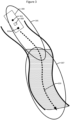
- Figure 1 illustrates a top view of a geographic map showing movement of a device between different regions and associated sensor activation/deactivation operations in accordance with some embodiments of the present disclosure.
- a geographic region PA is illustrated where Sensor A satisfies a localization performance rule
- another geographic region PB is illustrated where Sensor B satisfies the localization performance rule
- an overlap region PX is illustrated where both Sensors A and B satisfy the localization performance rule.
- Sensor B When the device moves along path segment PF_B from region PA to region PX, where Sensors A and B both satisfy the localization performance rule, Sensor B may be activated and Sensor A may be deactivated depending upon the relative power consumption, localization performance, combined localization and mapping performance (e.g., SLAM performance), resource utilization, etc., of Sensors A and B.
- region PX localization can be performed using data from one or both of Sensors A and B.
- Sensor B actively feeds data to the localization algorithm or combined localization and mapping algorithm, e.g., SLAM algorithm, and Sensor A is deactivated.
- a localization performance rule can include a set of conditions which can be the same or different for each of the sensors.
- the condition(s) that are used to determine whether one sensor satisfies the localization performance rule can be the same or different from the condition(s) that are evaluated to determine whether another sensor satisfies the localization performance rule.
- the conditions(s) can depend upon the operational characteristics of the respective sensors, such as operational characteristics of a visible light (RGB) camera, the operational characteristics of an infrared (IR) camera, the operational characteristics of a LIDAR sensor, etc.
- Figure 3 illustrates a top view of a geographic map showing movement of a vehicle 300 transporting a device 400 that performs localization using a set of sensors 301 and 303 that are transportable with the device 400.
- the device and sensors may be transported in other ways, such as by a human, robot, aircraft (e.g., drone), ship, etc.
- the device 400 can be, but is not limited to, a component of any of a smartphone, wearable computer, augmented reality headset, virtual reality headset, mixed reality headset, semi-autonomous or autonomous vehicle, drone, aircraft, robot, etc.
- sensors configured to perform localization operations or combined localization and mapping operations, e.g., SLAM, using any plural number of sensors that are configured to feed an appropriate type of data.
- Example types of sensors include, but are not limited to, RGB visible light camera, infrared camera, stereo cameras, inertial measurement unit (IMU), radar sensor, light detection and ranging (LIDAR) sensor, acoustic ranging sensor, proximity sensor, GPS, and RF transceiver (e.g., 5G-radio).
- the device 400 performs localization operations or combined localization and mapping operations, e.g. SLAM, using one or more of the sensors 301 and 303 to sense features of the environment in a proximate region. For example, in a first region 305 the first sensor 301 is active and the second sensor 303 is deactivated. The device 400 determines that the first sensor 301 satisfies a localization performance rule, which results in the device maintaining the first sensor 301 activated and the second sensor 303 deactivated while the vehicle 300 remains in the first region 305.
- SLAM localization operations or combined localization and mapping operations
- Sensor 301 can be deemed to satisfy the localization performance rule when its data processed by a localization algorithm results in device localization with an accuracy which satisfies the localization performance rule.
- the vehicle 300 subsequently travels into a second region 307 where the device 400 determines that the second sensor 303 can satisfy the localization performance rule.
- Sensor 303 can be deemed to satisfy the localization performance rule when an estimate of the accuracy of device localization that would be achieved using data from sensor 303 would satisfy the localization performance rule.
- the device 400 can identify a pose, e.g., a location and/or orientation within region 307, where localization processing can switch from using sensor 301 to using sensor 303.
- the pose may correspond to a set of poses corresponding to the device 400 being anywhere within the overlap of regions 305 and 307.
- Sensor 303 can be activated before the switch and sensor 301 can be deactivated after the switch to avoid degradation or failure of the device 400 localization.
- the operation to switch the localization operation from using data from sensor 301 to instead using data from sensor 303 may include a period of time when the localization operation uses data from both sensors 301 and 303.
- the device 400 is configured to switch between different types of sensors based on their respective localization performance as a function of differing characteristics of geographic areas the device 400 is moved through.
- the device 400 may also be configured to control the switching based on how much energy the different sensors consume and/or how much other system resources, e.g., processing, memory, communication bandwidth, etc., are utilized to receive, store, and/or process through algorithms data from the sensors.
- the decision to activate and deactivate sensors and to switch from using one sensor to using another sensor for localization operations can be performed based on a combination of the localization performance that can be achieved using data from the perspective and based on how much energy or other resources are used by the respective sensors.
- the switch from using one sensor to using another sensor can be delayed until the device reaches a pose where the localization operation can be performed without reduction in accuracy of the localization operation or without an unacceptable reduction in accuracy of the localization operation, e.g., to prevent failure of the localization operation during the switch between sensors and resulting loss of tracking of the device pose.
- the device is configured to perform the following operations:
- a further operation is defined for controlling activation and deactivation of sensors transported with a device performing localization operations for performing combined localization and mapping operations, e.g., SLAM operations.
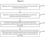
- the device is configured to perform operations that include determining 601 a first set of device poses (PA) where a first sensor satisfies a localization performance rule.
- the operations further determine 603 a second set of device poses (PB) where a second sensor satisfies the localization performance rule.
- the operations responsively activate 605 the second sensor based on a pose of the second sensor device transitioning from not being within to being within the second set of device poses (PB).
- the operations deactivate 607 the first sensor based on a pose of the first sensor device transitioning from being within to not being within the first set of device poses (PA) while poses of the device remain within the second set of device poses (PB).
- the operations direct 701 movement of the device to transition a pose of the second sensor from not being within to being within the second set of device poses (PB).
- the operations to direct 701 movement of the device may include providing information through a user interface of the device (e.g., displaying information, generating audible information, generating tactile feedback, etc.) that guides a user how to move the device to transition poses of the device from not being within to being within the second set of device poses (PB).
- the operations to direct 701 movement of the device may include providing guidance information to a navigation system of the device that controls movement of the device and sensors (e.g., an autonomous vehicle or semi-autonomous vehicle) to transition poses of the device from not being within to being within the second set of device poses (PB).
- a navigation system of the device that controls movement of the device and sensors (e.g., an autonomous vehicle or semi-autonomous vehicle) to transition poses of the device from not being within to being within the second set of device poses (PB).
- sensors e.g., an autonomous vehicle or semi-autonomous vehicle
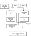
- Figure 2 illustrates a system diagram of the device components used for activating and deactivating sensors while performing localization or performing localization and mapping operations such as SLAM in accordance with some embodiments of the present disclosure.
- the performance of both Sensor A and B is analyzed (component 207) based on prior performance (e.g., localization performance, combined localization and mapping performance, SLAM performance) and associated device poses which are obtained from component 210, and the analyzed performance and associated device poses are stored in a geographic map (component 211).
- the analyzed performance is then used to determine (component 215) the desired poses PF_A and PF_B where the Sensors A and B should be deactivated and activated respectively.
- This information is provided to a sensor selector block (component 209) which decides which sensor should be selected to provide sensor information to the SLAM algorithm (component 213).
- An indication or actuation is provided (component 217) to the user or device as guidance for how to move the device to obtain pose PF_A and PF_B.
- the device determines the first set of device poses where the Sensor A satisfies a localization performance rule, determines a second set of device poses where Sensor B satisfies the localization performance rule, activates Sensor B while the Sensor A is active based on a pose of the device transitioning from not being within to being within the second set of device poses. In this manner, the device can control activation of the Sensor B and timing for when it switches from performing localization using data from Sensor A to using data from Sensor B based on a device pose being achieved which will provide acceptable localization performance.
- SLAM localization and mapping
- localization performance or localization and mapping (e.g., SLAM) performance can be quantified by one of many factors, including but not limited to the number of false re-localizations, amount and quality of features in a region, the localization error (position and orientation of the device), position/orientation drifts, among other metrics.
- False re-localization can correspond to error associated with when a device has localized itself in a wrong part of a map, which is not where the device is located.
- Localization error can correspond to a difference between an estimated pose of the device and the actual pose of the device.
- False re-localizations and localization error can typically be characterized with higher certainty and/or accuracy aposteriori after a SLAM session is complete, for example when the map is further optimized and several devices/agents have contributed with information to improve said map.
- the sensor data from the previous passage in that area can be fed again to the SLAM algorithm with an optimized map and a comparison can be made between the new and the old trajectory and an error can be computed.
- known features are available in a region with known ground truth poses, as e.g. fiducial markers, specific objects or environment features such as a door, a window, etc. a localization error can be computed against said landmarks.
- the determination 601 of the first set of device poses (PA) where the first sensor satisfies the localization performance rule may include determining a localization performance score for the first sensor at one or more poses based on at least one of a determined number of false re-localizations determined based on data from the first sensor, a determined number and quality of measurements of features in a region measured by data from the first sensor, a localization error determined based on data from the first sensor, and an amount of uncertainty in measurements based on data from the first sensor.
- the determination 601 may alternatively or additionally include determining whether the localization performance score of the first sensor at the one or more poses satisfies the localization performance rule.
- the determination 603 of the second set of device poses (PB) where the second sensor satisfies the localization performance rule can include determining a localization performance score for the second sensor at one or more poses based on at least one of a determined number of false re-localizations determined based on data from the second sensor, a determined number and quality of features in a region measured by data from the second sensor, and a localization error determined based on data from the second sensor.
- the determination 603 whether the second sensor satisfies the localization performance rule may include determining whether the localization performance score of the second sensor at the one or more poses satisfies the localization performance rule.
- the information collected to quantify the localization performance or localization and mapping (e.g., SLAM) performance is collected and stored in a localization map which indicates for defined poses or areas in the map what performance information is obtained using various sensors.
- This information may be collected by both the current device when the sensors were respectively active, and may be collected from other devices which have previously been at these locations and with the same type of sensors or other types of sensors being actively used for localization.
- the map may store information that identifies poses which are associated with performance data for different sensors. The performance data may be retrieved from the map for particular sensor identifiers (unique to each sensor), based on types of sensors (e.g.
- the device may query the map using a particular sensor identifier, using a type of sensor, or using one or more operational characteristics of a sensor in order to determine from the information in the map a pose of the device or set of poses of the device for which the sensor will satisfy a localization performance rule (i.e., output data that when processed through a localization algorithm will provide device localization that satisfies the localization performance rule).
- a localization performance rule i.e., output data that when processed through a localization algorithm will provide device localization that satisfies the localization performance rule.
- the determination 601 of the first set of device poses (PA) where the first sensor satisfies the localization performance rule includes determining 901 localization of the first sensor relative to a map defined by a data structure identifying previously sensed features of a localized environment, i.e., features of the environment that were previously sensed by the first sensor, another sensor that is operationally similar to the first sensor, and/or another type of sensor.
- the determination 601 also includes determining 903 a localization performance score for the first sensor with the device at one or more poses based on whether the first sensor senses the previously sensed features identified by the data structure.
- the determination 601 also includes determining 905 whether the localization performance score for the first sensor with the device at the one or more poses satisfies the localization performance rule.
- the determination 603 of the second set of device poses (PB) where the second sensor satisfies the localization performance rule includes determining 1001 a localization performance score for the second sensor with the device at one or more poses based on whether the second sensor senses the previously sensed features identified by the data structure.
- the determination 603 also includes determining 1003 whether the localization performance score for the second sensor with the device at the one or more poses satisfies the localization performance rule based on whether the second sensor senses the previously sensed features identified by the data structure.
- the determination 601 of the first set of device poses (PA) where the first sensor satisfies the localization performance rule includes determining 1101 localization of the first sensor relative to a map defined by a data structure identifying positions of features of a localized environment, which may have been defined by a user in the data structure, previously sensed and added to the data structure, or input to the data structure by any other process.
- the determination 601 also includes determining 1103 a localization performance score for the first sensor with the device at one or more poses based on comparison of where the first sensor identifies the positions of the features to where the data structure identifies the positions of the features.
- the determination 601 also includes determining 1105 whether the localization performance score for the first sensor with the device at the one or more poses satisfies the localization performance rule.
- the determination 603 of the second set of device poses (PB) where the second sensor satisfies the localization performance rule includes determining 1201 a localization performance score for the second sensor with the device at one or more poses based on comparison of where the second sensor identifies the positions of the features to where the data structure identifies the positions of the features.
- the determination 603 also includes determining 1203 whether the localization performance score for the second sensor with the device at the one or more poses satisfies the localization performance rule.
- the determination 601 of the first set of device poses PA where the first sensor satisfies the localization performance rule includes determining 1301 localization of the device to locations within a map defined by a data structure which identifies localization performance scores for devices at the locations.
- the determination 601 also includes retrieving 1303 a localization performance score for the first sensor from the data structure based on the localization of the device to the locations.
- the determination 601 also includes determining 1305 whether the localization performance score for the first sensor satisfies the localization performance rule.
- the determination 603 of the second set of device poses (PB) where the second sensor satisfies the localization performance rule includes retrieving 1401 a localization performance score for the second sensor from the data structure based on the localization of the device to the locations.
- the determination 601 also includes determining 1403 whether the localization performance score for the second sensor satisfies the localization performance rule.
- the localization performance scores for first and second sensors are determined based on accessing the data structure of the map stored in a networked data repository, e.g., the map repository 431 in the SLAM support node 427 of Figure 4 .
- the localization performance scores for first and second sensors are determined based on accessing the data structure of the map repository 402 stored in the memory 404 of the device 400.
- Some embodiments are directed to detecting a need for activating one sensor and for deactivating another sensor which may be motivated by one or both of the following embodiments.
- a current or predicted decrease of the localization performance when using Sensor A is determined, where it is believed that Sensor B will perform better.
- Sensor A is a monocular camera and Sensor B a LIDAR
- the current or predicted region may contain few visual features to be detected by Sensor A, while the structure of the environment may be well tracked by Sensor B.
- Sensor B based on recorded information, it is known that the light conditions or the visual texture of the environment in different parts of a building are different which have seriously impacted the localization performance at previous occasions. This information can be extracted from the map built with the localization performance based on Sensor A and B.
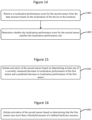
- the operations can further include initiating 1501 activation of the second sensor (Sensor B) based on determining at least one of a currently measured decrease in localization performance of the first sensor (Sensor A) and a predicted decrease in localization performance of the first sensor (Sensor A).
- the operations can further include initiating 1601 activation of the second sensor (Sensor B) based on determining that the first sensor (Sensor A) uses more than a threshold amount of a defined hardware resource.
- the defined hardware resources may include at least one of power consumption, processor utilization, memory utilization, and network communication utilization.
- Some embodiments are directed to determining device poses PA and PB, which may include the operations discussed below.
- a search is made for device poses Z where the localization performance using Sensor X is above a certain threshold.
- the pose set Z may encompass all possible poses for the device, or it may be optimized for the most suitable poses (e.g. do not consider poses where the device is pointing to the floor or to the ceiling, etc.).
- the search in the map is performed within a region that is maximum Y meters away from the current position of the device, for a given set of poses Z.
- the value of Y can be defined based on the energy available, the deadline for performing the sensor transition, the current and predicted trajectory of the device, among other parameters.
- the method for performing localization using a set of sensors 401, 403, and 405, that are transportable with the device 400 further includes searching 801 among the second set of device poses (PB) to identify a subset of at least one device pose for the second sensor (Sensor B) where localization performance of the second sensor (Sensor B) satisfies the localization performance rule.
- the directing 701 of the movement of the device is performed to guide movement of the second sensor (Sensor B) toward the at least one device pose in the subset.
- the searching 801 among the second set of device poses (PB) may be constrained to identifying only poses among the second set of device poses (PB) that are within a threshold distance away from a present location of the device.
- the threshold distance may be determined based on at least one of remaining battery power within the device, remaining time before occurrence of a deadline for performing sensor transition, and an amount of deviation from a current movement trajectory of the device that would be needed for the device to be moved to one of the second set of device poses (PB).
- the operations to search 801 among the second set of device poses (PB) may be constrained to identifying only poses among the second set of device poses (PB) that are within a threshold closeness to a present pose of the second sensor.
- the operations to search 801 among the second set of device poses (PB) may be performed to identify poses among the second set of device poses (PB) where the first and second sensors will both have SLAM performance that satisfy the SLAM performance rule.
- the operations to direct 701 movement of the device to transition a pose of the device from not being within to being within the second set of device poses (PB), may include identifying a sequence of device poses from among the second set of device poses (PB), and directing movement of the device to transition the device through the sequence of device poses while performing operations to activate the second sensor and deactivate the first sensor.
- Some further embodiments are directed to determining a device pose PF_B which is the pose at which Sensor B should be activated, and determining the device pose PF_A which is the pose at which Sensor A should be deactivated.
- PF based on pose sets PA and PB, it is determined the pose set PX which is contained in set PA and PB, which is the intersection of both sets, e.g., overlap of regions 305 and 307 in Figure 3 .
- the final pose PF can then be determined in various ways, for example PF may be the pose which is the closest to the current device pose P, or the pose which maximizes the localization performance for both Sensors A and B, or a combination of both.
- the pose PF may also be a set of continuous poses to be followed by the device (i.e. trajectory), which may contain the set of poses PF_A where Sensor A will perform well, followed by the set of poses PF_AB where both sensors perform have a localization performance above a certain threshold, followed by the set of poses PF_B where only Sensor B performs well.
- the device i.e. trajectory
- the set of poses PF_A where Sensor A will perform well
- the set of poses PF_AB where both sensors perform have a localization performance above a certain threshold
- the set of poses PF_B where only Sensor B performs well.
- the current map is enhanced in desired areas/poses so that the localization performance, e.g., SLAM performance, in those desired areas is above a defined threshold.
- the localization performance e.g., SLAM performance
- Sensor A is an RGB+IMU
- Sensor B is a depth sensor or 3D sensor such as a LiDAR or stereo camera
- this enhancement could be to densify RGB+IMU data to get better depth features in a certain area so that the depth sensor or 3D sensor can perform better localization in such area when turned on.
- the enhancement could be to download additional keyframes to the device so that the RGB+IMU sensor can perform better when turned on.
- the information retrieved from the map to compute the performance of a given sensor in a given area is weighted based on the temporal characteristics of the information. For example, more trust is placed on data that has been captured recently. Additionally, more trust can be placed on data which was captured at the same time of the day so that the light conditions are likely to be the same.
- the fusion of the information between the two sensors is performed so that a higher localization performance can be achieved.
- Figure 4 illustrates a system 450 that includes a pair of devices 400 and 410 which are each connected to respective sets of sets of sensors and operate in accordance with some embodiments of the present disclosure.
- the example system 450 can further include a SLAM support node 427.
- SLAM support node 427 Although the system of Figure 4 is described in the context of activating and deactivating sensors during SLAM processing, these embodiments are not limited to use with SLAM and can more generally be used to activate and deactivate sensors during localization operations or during combined localization and mapping operations which may or may not be based on SLAM.
- a first device 400 can include or be operationally connected to a first set of sensors 401, 403, and 405, that can be transported with the first device 400.
- a second device 410 can include or be operationally connected to a second set of sensors 411, 413, and 415, that can be transported with the second device 410.
- the first device 400 determines 601 ( Fig. 6 ) a first set of device poses (PA) where a first sensor (e.g., sensor 401) satisfies a localization performance rule and determines 603 ( Fig. 6 ) a second set of device poses (PB) where a second sensor (e.g., sensor 403) satisfies the localization performance rule.
- PA first set of device poses
- PB second set of device poses
- the first device 400 can be assisted in performing the determinations 601 and/or 603 based on information that is obtained from the second device 410 and/or from the SLAM support node 427. For example, when the first device 400 is proximately located to the second device 410, the first device 400 may operationally assume it can successfully use for localization the same or sufficiently similar types of sensors as what the second device 410 is actively using to perform localization.
- the first device 400 may be configured to query the second device 410 to obtain a listing of sensors (e.g., one or more sensors) that the second device 410 is actively using to perform localization, and then determine from the listing which, if any, of the sensors in its first set 401, 403, and 405, can be used to perform localization while satisfying the localization performance rule.
- sensors e.g., one or more sensors
- the first device 400 is proximately located to the second device 410
- the first second of sensors 401, 403, and 405 are respectively identical (or respectively satisfy a threshold level of operational similarity) to the second set of sensors 411, 413, and 405, and assume the second device 410 reports that it is actively using sensor 411 and is not using sensors 413 and 415 for localization.
- the first device 400 can then correspondingly determine that it is presently posed where sensor 401 will satisfy the localization performance rule (e.g., based on devices 400 and 410 being proximately located and sensor 411 being actively used by second device 410), and further determine that sensors 403 and 405 will not satisfy the localization performance rule.
- the first device 400 can be assisted in performing localization using data from one or more of the sensors 411, 413, and 415, of the second set being transported with the second device 410. For example, when the first device 400 is proximately located to the second device 410 and is further communicatively connected to the second device 410 via a sufficient bandwidth communication channel, the first device 400 may query the second device 410 to obtain a listing of sensors (e.g., one or more sensors) that the second device 410 is actively using to perform localization, and then determine from the listing which, if any, of the sensors in the second set 411, 413, and 415, can be used by the first device 400 to perform localization while satisfying the localization performance rule.
- sensors e.g., one or more sensors
- the first device 410 may use the received listing to decide to switch from using one or more of the sensors in the first set 401, 403, and 405, to using data from one or more sensors in the second set 411, 413, and 415, for localization of the first device 400.
- the first device 400 may request the second device 410 to activate one of the sensors in the second set 411, 413, and 415, and to further provide data from the activated senor to the first device 400 based on the first device 400 determining that, for example, none of the sensors in the first set 401, 403, and 405, will satisfy the localization performance rule for a present pose of the first device 400.
- the first device 400 and the second device 410 can be, but are not limited to, a component of any of a smartphone, wearable computer, augmented reality headset, virtual reality headset, mixed reality headset, semi-autonomous or autonomous vehicle, aircraft, robot, ship, etc.
- the first device 400 and the second device 410 and their connected sensors are transportable in any manner, such as by a person, vehicle, drone, aircraft, ship, robot, etc.
- Example types of sensors include, but are not limited to, RGB visible light camera, infrared camera, inertial measurement unit (IMU), radar sensor, stereo cameras (visible and/or infrared), light detection and ranging (LIDAR) sensor, acoustic ranging sensor, proximity sensor, GPS, and RF transceiver (e.g., 5G-radio).
- the first device 400 includes a SLAM (or localization) processor 409, a memory 404, and a wireless transceiver 407 that can communicate with the second device 310 and/or SLAM (or localization) support node 427 via a radio access node (RAN) 421 or 423.
- the processor 409 is operationally connected to the first set of sensors 401, 403, 405.
- the memory 404 stores program code that is executed by the processor 409 to perform operations, and may store a map repository 402.
- the operations performed by the SLAM processor 409 can include some or all of the operations described herein relating to controlling sensor activation and/or deactivation and, more particularly, the operations described herein in the context of any one or more of Figures 6-16 .
- the second device 410 can be similarly configured to the first device 400.
- the second device 410 includes the set of sensors 411, 413, and 415, a SLAM (or localization) processor 419, a wireless transceiver 417, and a memory 414 storing program code that is executed by the processor 419 to perform operations and may further store a map repository 412.
- the processor is operationally connected to the set of sensors 411, 413, and 415.
- the first device 400 and/or the second device 410 can be configured to contain program code and related circuitry needed to perform operations to control sensor activation and deactivation and perform localization operations and may further perform mapping operations, such as SLAM algorithm processing. Some of the localization and/or mapping operations for the first device 400 may be performed by a networked node, such as the illustrated SLAM support node 427, and/or by the second device 410. Similarly, some of the localization and/or mapping operations for the second device 410 may be performed by a networked node, such as the illustrated SLAM support node 427, and/or by the first device 400.
- the devices 400 and 410 can be configured to communicate with the SLAM support node 427 via one or more of the radio access networks (RANs) 421 and 423 and the networks 425.
- the SLAM support node 427 includes a processor 433 that can be configured to perform some or all of the operations for activating and deactivating sensors transported with the first device 400 and/or the second device 410 according to one or more of the embodiments disclosed herein.
- the SLAM support node 427 may store the MAP repository 431 that can be used to determine which sensors to activate or deactivate, and to determine when to activate or deactivate sensors based on poses of the first device 400 and/or the second device 410.
- Figure 5 illustrates a mixed-reality (MR) system that includes a MR headset 500 that holds a mobile electronic device 520 which can include (e.g., built-in) a camera 522 and be operationally connected to a set of sensors 533, 535, etc.
- the mobile electronic device 520 can include a processor and a memory storing program code that configures the processor to activate and deactivate individual ones of the sensors 522, 533, 535 while using the active ones of the sensors 522, 533, 535 to perform localization.
- the MR headset 500 includes a lens 510 through which a user who is wearing the MR headset can view real-world features.
- the MR headset 500 further includes a holder 521 that is configured to releasably retain the mobile electronic device 520 in a defined orientation relative to the lens 510.
- the mobile electronic device 520 includes a display device and a processor.
- the camera 522 is configured to output digital pictures (e.g., still pictures and/or video) and arranged by the holder 521 to view at least a portion of the lens 510 of the MR headset 500.
- the display device is arranged to display information that is projected on the lens 510 for reflection directly or indirectly toward the user's eyes, i.e., while wearing the MR headset 500, and the camera 533 of the mobile electronic device 520.
- the headset may include intervening mirrors that are positioned between the lens 510 and the user's eyes and/or the camera 522 and, hence the light may be reflected directly or indirectly toward the user's eyes and/or the camera 522.
- the mobile electronic device 520 can include, but is not limited to, a smart phone, a palmtop computer, a tablet computer, gaming device, or other computing device.
- a “mobile electronic device” is also referred to herein as a “mobile device” and “device” for brevity.
- the terms “comprise”, “comprising”, “comprises”, “include”, “including”, “includes”, “have”, “has”, “having”, or variants thereof are open-ended, and include one or more stated features, integers, elements, steps, components or functions but does not preclude the presence or addition of one or more other features, integers, elements, steps, components, functions or groups thereof.
- the common abbreviation “e.g.”, which derives from the Latin phrase “exempli gratia” may be used to introduce or specify a general example or examples of a previously mentioned item, and is not intended to be limiting of such item.
- the common abbreviation “i.e.”, which derives from the Latin phrase “id est,” may be used to specify a particular item from a more general recitation.
- Example embodiments are described herein with reference to block diagrams and/or flowchart illustrations of computer-implemented methods, apparatus (systems and/or devices) and/or computer program products. It is understood that a block of the block diagrams and/or flowchart illustrations, and combinations of blocks in the block diagrams and/or flowchart illustrations, can be implemented by computer program instructions that are performed by one or more computer circuits.
- These computer program instructions may be provided to a processor circuit of a general purpose computer circuit, special purpose computer circuit, and/or other programmable data processing circuit to produce a machine, such that the instructions, which execute via the processor of the computer and/or other programmable data processing apparatus, transform and control transistors, values stored in memory locations, and other hardware components within such circuitry to implement the functions/acts specified in the block diagrams and/or flowchart block or blocks, and thereby create means (functionality) and/or structure for implementing the functions/acts specified in the block diagrams and/or flowchart block(s).
Landscapes
- Engineering & Computer Science (AREA)
- Remote Sensing (AREA)
- Radar, Positioning & Navigation (AREA)
- Physics & Mathematics (AREA)
- General Physics & Mathematics (AREA)
- Automation & Control Theory (AREA)
- Computer Networks & Wireless Communication (AREA)
- Theoretical Computer Science (AREA)
- Electromagnetism (AREA)
- Aviation & Aerospace Engineering (AREA)
- General Engineering & Computer Science (AREA)
- Multimedia (AREA)
- Computer Vision & Pattern Recognition (AREA)
- Signal Processing (AREA)
- Control Of Position, Course, Altitude, Or Attitude Of Moving Bodies (AREA)
- Navigation (AREA)
- Auxiliary Devices For Music (AREA)
Claims (19)
- Vorrichtung (400), die zum Durchführen einer Lokalisierung unter Verwendung eines Satzes von Sensoren (401, 402, 403) konfiguriert ist, der einen ersten Sensor und einen zweiten Sensor beinhaltet, die mit der Vorrichtung (400) transportierbar sind, wobei die Vorrichtung (400) Folgendes umfasst:mindestens einen Prozessor (409), der mit dem Satz von Sensoren (401, 403, 405) wirkverbunden ist;mindestens einen Speicher (404), der Programmcode speichert, der den mindestens einen Prozessor zu Folgendem konfiguriert:Bestimmen (601) eines ersten Satzes von Vorrichtungsstellungen (PA), bei dem der erste Sensor eine Lokalisierungsleistungsregel für den ersten Sensor erfüllt, die als erfüllt gilt, wenn Daten von dem ersten Sensor, die durch einen Lokalisierungsvorgang verarbeitet werden, zu einer Vorrichtungslokalisierung mit einer Genauigkeit führen, die eine Bedingung für den ersten Sensor erfüllt;Bestimmen (603) eines zweiten Satzes von Vorrichtungsstellungen (PB), bei dem der zweite Sensor eine Lokalisierungsleistungsregel für den zweiten Sensor erfüllt, die als erfüllt gilt, wenn Daten von dem zweiten Sensor, die durch den Lokalisierungsvorgang verarbeitet werden, zu einer Vorrichtungslokalisierung mit einer Genauigkeit führen, die eine Bedingung für den zweiten Sensor erfüllt;Lenken (701) einer Bewegung der Vorrichtung (400), um eine Stellung der Vorrichtung (400) von nicht innerhalb des zweiten Satzes von Vorrichtungsstellungen (PB) zu innerhalb dessen übergehen zu lassen; undAktivieren (605) des zweiten Sensors, während der erste Sensor aktiv ist, basierend auf einer Stellung der Vorrichtung, die von nicht innerhalb des zweiten Satzes von Vorrichtungsstellungen (PB) zu innerhalb dessen übergeht.
- Vorrichtung nach Anspruch 1, wobei der Programmcode ferner den mindestens einen Prozessor konfiguriert, um den ersten Sensor basierend auf einer Stellung der Vorrichtung zu deaktivieren (607), die von innerhalb des ersten Satzes von Vorrichtungsstellungen (PA) zu nicht innerhalb dessen übergeht, während Stellungen der Vorrichtung innerhalb des zweiten Satzes von Vorrichtungsstellungen (PB) verbleiben.
- Vorrichtung nach Anspruch 1, wobei das Lenken (701) der Bewegung der Vorrichtung das Bereitstellen von Informationen über eine Benutzerschnittstelle der Vorrichtung umfasst, die die Bewegung der Vorrichtung derart führt, dass Stellungen der Vorrichtung von nicht innerhalb des zweiten Satzes von Vorrichtungsstellungen (PB) zu innerhalb dessen übergehen.
- Vorrichtung nach einem der Ansprüche 2 bis 3, wobei das Lenken (701) der Bewegung der Vorrichtung das Bereitstellen von Führungsinformationen für ein Navigationssystem der Vorrichtung umfasst, das die Bewegung der Vorrichtung derart steuert, dass Stellungen der Vorrichtung von nicht innerhalb des zweiten Satzes von Vorrichtungsstellungen (PB) zu innerhalb dessen übergehen.
- Vorrichtung nach einem der Ansprüche 2 bis 4, ferner Folgendes umfassend:Durchsuchen (801) des zweiten Satzes von Vorrichtungsstellungen (PB), um einen Teilsatz von mindestens einer Vorrichtungsstellung zu identifizieren, bei dem die Lokalisierungsleistung des zweiten Sensors die Lokalisierungsleistungsregel für den zweiten Sensor erfüllt,wobei das Lenken (701) der Bewegung der Vorrichtung durchgeführt wird, um die Bewegung des zweiten Sensors zu der mindestens einen Vorrichtungsstellung in dem Teilsatz zu führen.
- Vorrichtung nach Anspruch 5, wobei das Durchsuchen (801) des zweiten Satzes von Vorrichtungsstellungen (PB) zum Identifizieren des Teilsatzes von mindestens einer Vorrichtungsstellung, bei dem die Lokalisierungsleistung des zweiten Sensors die Lokalisierungsleistungsregel für den zweiten Sensor erfüllt, darauf beschränkt ist, nur Stellungen in dem zweiten Satz von Vorrichtungsstellungen (PB) zu identifizieren, die innerhalb eines Schwellenwertabstands von einem gegenwärtigen Standort der Vorrichtung entfernt sind.
- Vorrichtung nach Anspruch 6, wobei der Schwellenwertabstand basierend auf mindestens einem von verbleibender Batterieleistung in der Vorrichtung, verbleibender Zeit vor Ablaufen einer Frist zum Durchführen eines Sensorübergangs und einem Betrag der Abweichung von einer aktuellen Bewegungsbahn der Vorrichtung, der erforderlich wäre, damit die Vorrichtung zu einer aus dem zweiten Satz von Vorrichtungsstellungen (PB) bewegt wird, bestimmt wird.
- Vorrichtung nach einem der Ansprüche 5 bis 7, wobei das Durchsuchen (801) des zweiten Satzes von Vorrichtungsstellungen (PB) zum Identifizieren des Teilsatzes von mindestens einer Vorrichtungsstellung, bei dem die Lokalisierungsleistung des zweiten Sensors die Lokalisierungsleistungsregel für den zweiten Sensor erfüllt, durchgeführt wird, um Stellungen in dem zweiten Satz von Vorrichtungsstellungen (PB) zu identifizieren, bei denen der erste und der zweite Sensor beide eine Lokalisierungsleistung aufweisen, die die Lokalisierungsleistungsregel für den ersten Sensor bzw. den zweiten Sensor erfüllt.
- Vorrichtung nach einem der Ansprüche 2 bis 7, wobei das Lenken (701) der Bewegung der Vorrichtung zum Übergehen einer Stellung der Vorrichtung von nicht innerhalb des zweiten Satzes von Vorrichtungsstellungen (PB) zu innerhalb dessen Folgendes umfasst:Identifizieren einer Abfolge von Vorrichtungsstellungen aus dem zweiten Satz von Vorrichtungsstellungen (PB); undLenken der Bewegung der Vorrichtung, um die Vorrichtung durch die Abfolge von Vorrichtungsstellungen übergehen zu lassen, während Vorgänge zur Aktivierung des zweiten Sensors und zur Deaktivierung des ersten Sensors durchgeführt werden.
- Vorrichtung nach einem der Ansprüche 1 bis 9, wobei:
das Bestimmen (601) des ersten Satzes von Vorrichtungsstellungen (PA), bei dem der erste Sensor die Lokalisierungsleistungsregel für den ersten Sensor erfüllt, Folgendes umfasst:Bestimmen einer Lokalisierungsleistungsbewertung für den ersten Sensor an einer oder mehreren Stellungen basierend auf mindestens einem von einer bestimmten Anzahl von falschen Neulokalisierungen, bestimmt basierend auf Daten des ersten Sensors, einer bestimmten Anzahl und Qualität von Messungen von Merkmalen in einer Region, gemessen durch Daten des ersten Sensors, einem Lokalisierungsfehler, bestimmt basierend auf Daten des ersten Sensors, und einem Betrag an Unsicherheit bei Messungen basierend auf Daten des ersten Sensors undBestimmen, ob die Lokalisierungsleistungsbewertung des ersten Sensors an der einen oder den mehreren Stellungen die Lokalisierungsleistungsregel für den ersten Sensor erfüllt; unddas Bestimmen (603) des zweiten Satzes von Vorrichtungsstellungen (PB), bei dem der zweite Sensor die Lokalisierungsleistungsregel für den zweiten Sensor erfüllt, Folgendes umfasst:Bestimmen einer Lokalisierungsleistungsbewertung für den zweiten Sensor an einer oder mehreren Stellungen basierend auf mindestens einem von einer bestimmten Anzahl von falschen Neulokalisierungen, bestimmt basierend auf Daten des zweiten Sensors, einer bestimmten Anzahl und Qualität von Messungen von Merkmalen in einer Region, gemessen durch Daten des zweiten Sensors, und einem Lokalisierungsfehler, bestimmt basierend auf Daten des zweiten Sensors, undBestimmen, ob die Lokalisierungsleistungsbewertung des zweiten Sensors an der einen oder den mehreren Stellungen die Lokalisierungsleistungsregel für den zweiten Sensor erfüllt. - Vorrichtung nach einem der Ansprüche 1 bis 10, wobei:
das Bestimmen (601) des ersten Satzes von Vorrichtungsstellungen (PA), bei dem der erste Sensor die Lokalisierungsleistungsregel für den ersten Sensor erfüllt, Folgendes umfasst:Bestimmen (901) der Lokalisierung der Vorrichtung relativ zu einer Karte, die durch eine Datenstruktur definiert ist, die zuvor erfasste Merkmale einer lokalisierten Umgebung identifiziert,Bestimmen (903) einer Lokalisierungsleistungsbewertung für den ersten Sensor mit der Vorrichtung in einer oder mehreren Stellungen basierend darauf, ob der erste Sensor die zuvor erfassten Merkmale erfasst, die durch die Datenstruktur identifiziert wurden, undBestimmen (905), ob die Lokalisierungsleistungsbewertung für den ersten Sensor mit der Vorrichtung in der einen oder den mehreren Stellungen die Lokalisierungsleistungsregel für den ersten Sensor erfüllt; unddas Bestimmen (603) des zweiten Satzes von Vorrichtungsstellungen (PB), bei dem der zweite Sensor die Lokalisierungsleistungsregel für den zweiten Sensor erfüllt, Folgendes umfasst:Bestimmen (1001) einer Lokalisierungsleistungsbewertung für den zweiten Sensor mit der Vorrichtung in einer oder mehreren Stellungen basierend darauf, ob der zweite Sensor die zuvor erfassten Merkmale erfasst, die durch die Datenstruktur identifiziert wurden, undBestimmen (1003), ob die Lokalisierungsleistungsbewertung für den zweiten Sensor mit der Vorrichtung in der einen oder den mehreren Stellungen die Lokalisierungsleistungsregel für den zweiten Sensor erfüllt, basierend darauf, ob der zweite Sensor die zuvor erfassten Merkmale erfasst, die durch die Datenstruktur identifiziert wurden. - Vorrichtung nach einem der Ansprüche 1 bis 11, wobei:
das Bestimmen (601) des ersten Satzes von Vorrichtungsstellungen (PA), bei dem der erste Sensor die Lokalisierungsleistungsregel für den ersten Sensor erfüllt, Folgendes umfasst:Bestimmen (1101) der Lokalisierung der Vorrichtung relativ zu einer Karte, die durch eine Datenstruktur definiert ist, die Positionen von Merkmalen einer lokalisierten Umgebung identifiziert,Bestimmen (1103) einer Lokalisierungsleistungsbewertung für den ersten Sensor mit der Vorrichtung in einer oder mehreren Stellungen basierend auf einem Vergleich der Identifizierung von Positionen der Merkmale durch den ersten Sensor mit einer Identifizierung von Positionen der Merkmale durch die Datenstruktur undBestimmen (1105), ob die Lokalisierungsleistungsbewertung für den ersten Sensor mit der Vorrichtung in der einen oder den mehreren Stellungen die Lokalisierungsleistungsregel für den ersten Sensor erfüllt; unddas Bestimmen (603) des zweiten Satzes von Vorrichtungsstellungen (PB), bei dem der zweite Sensor die Lokalisierungsleistungsregel für den zweiten Sensor erfüllt, Folgendes umfasst:Bestimmen (1201) einer Lokalisierungsleistungsbewertung für den zweiten Sensor mit der Vorrichtung in einer oder mehreren Stellungen basierend auf einem Vergleich der Identifizierung von Positionen der Merkmale durch den zweiten Sensor mit einer Identifizierung von Positionen der Merkmale durch die Datenstruktur undBestimmen (1203), ob die Lokalisierungsleistungsbewertung für den zweiten Sensor mit der Vorrichtung in der einen oder den mehreren Stellungen die Lokalisierungsleistungsregel für den zweiten Sensor erfüllt. - Vorrichtung nach einem der Ansprüche 1 bis 12, wobei:
das Bestimmen (601) des ersten Satzes von Vorrichtungsstellungen (PA), bei dem der erste Sensor die Lokalisierungsleistungsregel für den ersten Sensor erfüllt, Folgendes umfasst:Bestimmen (1301) der Lokalisierung der Vorrichtung an Standorten innerhalb einer Karte, die durch eine Datenstruktur definiert ist, die Lokalisierungsleistungsbewertungen für Vorrichtungen an den Standorten identifiziert;Abrufen (1303) einer Lokalisierungsleistungsbewertung für den ersten Sensor aus der Datenstruktur basierend auf der Lokalisierung der Vorrichtung zu den Standorten; undBestimmen (1305), ob die Lokalisierungsleistungsbewertung für den ersten Sensor die Lokalisierungsleistungsregel für den ersten Sensor erfüllt; unddas Bestimmen (603) des zweiten Satzes von Vorrichtungsstellungen (PB), bei dem der zweite Sensor die Lokalisierungsleistungsregel für den zweiten Sensor erfüllt, Folgendes umfasst:Abrufen (1401) einer Lokalisierungsleistungsbewertung für den zweiten Sensor aus der Datenstruktur basierend auf der Lokalisierung der Vorrichtung zu den Standorten; undBestimmen (1403), ob die Lokalisierungsleistungsbewertung für den zweiten Sensor die Lokalisierungsleistungsregel für den zweiten Sensor erfüllt. - Vorrichtung nach einem der Ansprüche 1 bis 13, wobei das Bestimmen (601) des ersten Satzes von Vorrichtungsstellungen (PA), bei dem der erste Sensor die Lokalisierungsleistungsregel für den ersten Sensor erfüllt, und das Bestimmen (603) des zweiten Satzes von Vorrichtungsstellungen (PB), bei dem der zweite Sensor die Lokalisierungsleistungsregel für den zweiten Sensor erfüllt, basierend auf dem Erhalten einer Liste von Sensoren bestimmt werden, die gegenwärtig zur Verwendung durch eine in der Nähe befindliche andere Vorrichtung aktiv sind.
- Vorrichtung nach einem der Ansprüche 1 bis 14, die ferner das Einleiten (1501) der Aktivierung des zweiten Sensors basierend auf dem Bestimmen von mindestens einer von einer aktuell gemessenen Abnahme der Lokalisierungsleistung des ersten Sensors und einer vorhergesagten Abnahme der Lokalisierungsleistung des ersten Sensors umfasst.
- Verfahren durch eine Vorrichtung, die eine Lokalisierung unter Verwendung eines Satzes von Sensoren durchführt, der einen ersten Sensor und einen zweiten Sensor beinhaltet, die mit der Vorrichtung transportiert werden, wobei das Verfahren Folgendes umfasst:Bestimmen (601) eines ersten Satzes von Vorrichtungsstellungen (PA), bei dem der erste Sensor eine Lokalisierungsleistungsregel für den ersten Sensor erfüllt, die als erfüllt gilt, wenn Daten von dem ersten Sensor, die durch einen Lokalisierungsvorgang verarbeitet werden, zu einer Vorrichtungslokalisierung mit einer Genauigkeit führen, die eine Bedingung für den ersten Sensor erfüllt;Bestimmen (603) eines zweiten Satzes von Vorrichtungsstellungen (PB), bei dem ein zweiter Sensor eine Lokalisierungsleistungsregel für den zweiten Sensor erfüllt, die als erfüllt gilt, wenn Daten von dem zweiten Sensor, die durch einen Lokalisierungsvorgang verarbeitet werden, zu einer Vorrichtungslokalisierung mit einer Genauigkeit führen, die eine Bedingung für den zweiten Sensor erfüllt;Lenken (701) einer Bewegung der Vorrichtung (400), um eine Stellung der Vorrichtung (400) von nicht innerhalb des zweiten Satzes von Vorrichtungsstellungen (PB) zu innerhalb dessen übergehen zu lassen; undAktivieren (605) des zweiten Sensors, während der erste Sensor aktiv ist, basierend auf einer Stellung der Vorrichtung, die von nicht innerhalb des zweiten Satzes von Vorrichtungsstellungen (PB) zu innerhalb dessen übergeht.
- Verfahren nach Anspruch 16, ferner umfassend das Durchführen von Vorgängen nach einem der Ansprüche 2 bis 15.
- Computerprogrammprodukt zum Durchführen einer Lokalisierung einer Vorrichtung unter Verwendung eines Satzes von Sensoren, der einen ersten Sensor und einen zweiten Sensor beinhaltet, die mit der Vorrichtung transportiert werden, wobei das Computerprogrammprodukt Folgendes umfasst:
ein nichtflüchtiges computerlesbares Medium, das Programmcode speichert, der durch mindestens einen Prozessor der Vorrichtung ausführbar ist, um den mindestens einen Prozessor zu Folgendem zu konfigurieren:Bestimmen eines ersten Satzes von Vorrichtungsstellungen (PA), bei dem der erste Sensor eine Lokalisierungsleistungsregel für den ersten Sensor erfüllt, die als erfüllt gilt, wenn Daten von dem ersten Sensor, die durch einen Lokalisierungsvorgang verarbeitet werden, zu einer Vorrichtungslokalisierung mit einer Genauigkeit führen, die eine Bedingung für den ersten Sensor erfüllt;Bestimmen eines zweiten Satzes von Vorrichtungsstellungen (PB), bei dem der zweite Sensor eine Lokalisierungsleistungsregel für den zweiten Sensor erfüllt, die als erfüllt gilt, wenn Daten von dem zweiten Sensor, die durch den Lokalisierungsvorgang verarbeitet werden, zu einer Vorrichtungslokalisierung mit einer Genauigkeit führen, die eine Bedingung für den zweiten Sensor erfüllt;Lenken (701) einer Bewegung der Vorrichtung (400), um eine Stellung der Vorrichtung (400) von nicht innerhalb des zweiten Satzes von Vorrichtungsstellungen (PB) zu innerhalb dessen übergehen zu lassen; undAktivieren des zweiten Sensors, während der erste Sensor aktiv ist, basierend auf einer Stellung der Vorrichtung, die von nicht innerhalb des zweiten Satzes von Vorrichtungsstellungen (PB) zu innerhalb dessen übergeht. - Computerprogrammprodukt nach Anspruch 18, wobei der Programmcode ferner den mindestens einen Prozessor konfiguriert, Vorgänge nach einem der Ansprüche 2 bis 15 durchzuführen.
Priority Applications (1)
| Application Number | Priority Date | Filing Date | Title |
|---|---|---|---|
| EP23167245.2A EP4220088B1 (de) | 2019-12-18 | 2019-12-18 | Lokalisierung mit sensoren, die mit einer vorrichtung transportierbar sind |
Applications Claiming Priority (1)
| Application Number | Priority Date | Filing Date | Title |
|---|---|---|---|
| PCT/EP2019/085964 WO2021121577A1 (en) | 2019-12-18 | 2019-12-18 | Localization using sensors that are tranportable with a device |
Related Child Applications (2)
| Application Number | Title | Priority Date | Filing Date |
|---|---|---|---|
| EP23167245.2A Division EP4220088B1 (de) | 2019-12-18 | 2019-12-18 | Lokalisierung mit sensoren, die mit einer vorrichtung transportierbar sind |
| EP23167245.2A Division-Into EP4220088B1 (de) | 2019-12-18 | 2019-12-18 | Lokalisierung mit sensoren, die mit einer vorrichtung transportierbar sind |
Publications (2)
| Publication Number | Publication Date |
|---|---|
| EP4078089A1 EP4078089A1 (de) | 2022-10-26 |
| EP4078089B1 true EP4078089B1 (de) | 2023-05-24 |
Family
ID=69024265
Family Applications (2)
| Application Number | Title | Priority Date | Filing Date |
|---|---|---|---|
| EP23167245.2A Active EP4220088B1 (de) | 2019-12-18 | 2019-12-18 | Lokalisierung mit sensoren, die mit einer vorrichtung transportierbar sind |
| EP19828267.5A Active EP4078089B1 (de) | 2019-12-18 | 2019-12-18 | Lokalisierung mittels sensoren, die mit einer vorrichtung transportierbar sind |
Family Applications Before (1)
| Application Number | Title | Priority Date | Filing Date |
|---|---|---|---|
| EP23167245.2A Active EP4220088B1 (de) | 2019-12-18 | 2019-12-18 | Lokalisierung mit sensoren, die mit einer vorrichtung transportierbar sind |
Country Status (5)
| Country | Link |
|---|---|
| US (1) | US12607464B2 (de) |
| EP (2) | EP4220088B1 (de) |
| KR (1) | KR102858425B1 (de) |
| CN (1) | CN114846296B (de) |
| WO (1) | WO2021121577A1 (de) |
Families Citing this family (2)
| Publication number | Priority date | Publication date | Assignee | Title |
|---|---|---|---|---|
| WO2024102042A1 (en) * | 2022-11-09 | 2024-05-16 | Telefonaktiebolaget Lm Ericsson (Publ) | Controlling a device to sense an environment around the device |
| EP4538641A1 (de) * | 2023-10-11 | 2025-04-16 | Mapsted Corp. | Verfahren und system zur kriterienbasierten lokalisierung mobiler vorrichtungen |
Family Cites Families (16)
| Publication number | Priority date | Publication date | Assignee | Title |
|---|---|---|---|---|
| US8532670B2 (en) * | 2010-06-02 | 2013-09-10 | Deutsche Telekom Ag | Apparatus, method, and system for sensing suppression for location-based applications |
| WO2013124990A1 (ja) * | 2012-02-22 | 2013-08-29 | トヨタ自動車株式会社 | 車両用遠隔制御システム、サーバー、および、遠隔操作端末 |
| US9476716B2 (en) * | 2013-03-22 | 2016-10-25 | Qualcomm Incorporated | Methods and apparatuses for location-triggered sensor initialization |
| US20150097731A1 (en) * | 2013-10-03 | 2015-04-09 | Motorola Mobility Llc | Gps/wifi indoor/outdoor detection |
| JP2016004340A (ja) * | 2014-06-16 | 2016-01-12 | セイコーエプソン株式会社 | 情報配信システム、頭部装着型表示装置、頭部装着型表示装置の制御方法、および、コンピュータープログラム |
| KR102297167B1 (ko) * | 2015-03-18 | 2021-09-01 | 에스케이플래닛 주식회사 | 위치 측정이 이루어지는 단말 및 그 동작 방법 |
| US20180348023A1 (en) * | 2015-06-09 | 2018-12-06 | Google Llc | Sensor Calibration Based On Environmental Factors |
| US10302482B2 (en) * | 2016-10-07 | 2019-05-28 | Microsoft Technology Licensing, Llc | Dynamic sensor performance adjustment |
| US10748075B2 (en) * | 2016-10-21 | 2020-08-18 | Stmicroelectronics, Inc. | Method and apparatus for energy efficient probabilistic context awareness of a mobile or wearable device user by switching between a single sensor and multiple sensors |
| CN110463165B (zh) | 2017-03-27 | 2022-05-17 | 索尼公司 | 信息处理装置、信息处理方法和记录介质 |
| US10839547B2 (en) * | 2017-09-28 | 2020-11-17 | Samsung Electronics Co., Ltd. | Camera pose determination and tracking |
| JP6891753B2 (ja) | 2017-09-28 | 2021-06-18 | ソニーグループ株式会社 | 情報処理装置、移動装置、および方法、並びにプログラム |
| US11301022B2 (en) * | 2018-03-06 | 2022-04-12 | Motorola Mobility Llc | Methods and electronic devices for determining context while minimizing high-power sensor usage |
| US11202006B2 (en) * | 2018-05-18 | 2021-12-14 | Samsung Electronics Co., Ltd. | CMOS-assisted inside-out dynamic vision sensor tracking for low power mobile platforms |
| US10931858B2 (en) * | 2019-04-25 | 2021-02-23 | The Boeing Company | Multi-plane image sensors for high resolution destination detection and tracking |
| US11232834B2 (en) * | 2019-10-29 | 2022-01-25 | Qualcomm Incorporated | Pose estimation in extended reality systems |
-
2019
- 2019-12-18 EP EP23167245.2A patent/EP4220088B1/de active Active
- 2019-12-18 CN CN201980103074.9A patent/CN114846296B/zh active Active
- 2019-12-18 KR KR1020227024570A patent/KR102858425B1/ko active Active
- 2019-12-18 EP EP19828267.5A patent/EP4078089B1/de active Active
- 2019-12-18 US US17/783,470 patent/US12607464B2/en active Active
- 2019-12-18 WO PCT/EP2019/085964 patent/WO2021121577A1/en not_active Ceased
Also Published As
| Publication number | Publication date |
|---|---|
| WO2021121577A1 (en) | 2021-06-24 |
| EP4220088B1 (de) | 2024-06-26 |
| EP4078089A1 (de) | 2022-10-26 |
| EP4220088A1 (de) | 2023-08-02 |
| CN114846296B (zh) | 2025-02-14 |
| EP4220088C0 (de) | 2024-06-26 |
| US12607464B2 (en) | 2026-04-21 |
| KR20220110585A (ko) | 2022-08-08 |
| KR102858425B1 (ko) | 2025-09-12 |
| BR112022012028A2 (pt) | 2022-09-06 |
| US20220412740A1 (en) | 2022-12-29 |
| CN114846296A (zh) | 2022-08-02 |
Similar Documents
| Publication | Publication Date | Title |
|---|---|---|
| CN109087335B (zh) | 一种人脸跟踪方法、装置和存储介质 | |
| CN109785368B (zh) | 一种目标跟踪方法和装置 | |
| US9971957B2 (en) | Terminal device, information processing device, object identifying method, program, and object identifying system | |
| EP4078520B1 (de) | Steuerung der sensoraktivierung und -deaktivierung zur energieeffizienten lokalisierung | |
| US11956752B2 (en) | Angle of arrival determination in electronic devices with fused decision from motion | |
| US20200089252A1 (en) | Guide robot and operating method thereof | |
| WO2018068771A1 (zh) | 目标跟踪方法、系统、电子设备和计算机存储介质 | |
| US11751008B2 (en) | Angle of arrival capability in electronic devices | |
| CN108449952B (zh) | 定位模式之间的转换 | |
| US9691153B1 (en) | System and method for using image data to determine a direction of an actor | |
| KR20200023974A (ko) | 회전형 라이다와 다중 카메라간의 센서 동기화 방법 및 그 장치 | |
| CN116668939B (zh) | 定位方法、寻物方法、装置、存储介质及电子设备 | |
| EP4104430B1 (de) | Tiefensensoraktivierung zur lokalisierung auf der basis von daten aus einer monokularen kamera | |
| EP4078089B1 (de) | Lokalisierung mittels sensoren, die mit einer vorrichtung transportierbar sind | |
| KR20160082391A (ko) | 함정전투체계의 표적 관리 방법 | |
| US20190383937A1 (en) | SWITCHING AMONG DISPARATE SIMULTANEOUS LOCALIZATION AND MAPPING (SLAM) METHODS IN VIRTUAL, AUGMENTED, AND MIXED REALITY (xR) APPLICATIONS | |
| CN115053259B (zh) | 基于来自深度传感器的数据的针对定位的单目相机激活 | |
| US10852138B2 (en) | Scalabale simultaneous localization and mapping (SLAM) in virtual, augmented, and mixed reality (xR) applications | |
| WO2026050412A1 (en) | Method and system for determining device orientation within augmented reality applications | |
| CN112291701B (zh) | 定位验证方法、装置、机器人、外部设备和存储介质 | |
| CA3043913C (en) | Method and system for mobile device processing timeout based localization | |
| WO2019233299A1 (zh) | 地图构建方法、装置及计算机可读存储介质 | |
| US20250076997A1 (en) | Method, apparatus, device and storage medium for positioning an entity controller | |
| BR112022012028B1 (pt) | Localização usando sensores transportáveis com um dispositivo | |
| CN118444676A (zh) | 一种机器人回充控制方法、装置、设备及存储介质 |
Legal Events
| Date | Code | Title | Description |
|---|---|---|---|
| STAA | Information on the status of an ep patent application or granted ep patent |
Free format text: STATUS: UNKNOWN |
|
| STAA | Information on the status of an ep patent application or granted ep patent |
Free format text: STATUS: THE INTERNATIONAL PUBLICATION HAS BEEN MADE |
|
| PUAI | Public reference made under article 153(3) epc to a published international application that has entered the european phase |
Free format text: ORIGINAL CODE: 0009012 |
|
| STAA | Information on the status of an ep patent application or granted ep patent |
Free format text: STATUS: REQUEST FOR EXAMINATION WAS MADE |
|
| 17P | Request for examination filed |
Effective date: 20220530 |
|
| AK | Designated contracting states |
Kind code of ref document: A1 Designated state(s): AL AT BE BG CH CY CZ DE DK EE ES FI FR GB GR HR HU IE IS IT LI LT LU LV MC MK MT NL NO PL PT RO RS SE SI SK SM TR |
|
| RIC1 | Information provided on ipc code assigned before grant |
Ipc: G01S 19/34 20100101ALN20221104BHEP Ipc: G06T 7/246 20170101ALI20221104BHEP Ipc: G01S 17/86 20200101ALI20221104BHEP Ipc: G05D 1/02 20200101ALI20221104BHEP Ipc: G01S 17/89 20200101ALI20221104BHEP Ipc: G01C 21/20 20060101AFI20221104BHEP |
|
| GRAP | Despatch of communication of intention to grant a patent |
Free format text: ORIGINAL CODE: EPIDOSNIGR1 |
|
| STAA | Information on the status of an ep patent application or granted ep patent |
Free format text: STATUS: GRANT OF PATENT IS INTENDED |
|
| RIC1 | Information provided on ipc code assigned before grant |
Ipc: G01S 19/34 20100101ALN20221214BHEP Ipc: G06T 7/246 20170101ALI20221214BHEP Ipc: G01S 17/86 20200101ALI20221214BHEP Ipc: G05D 1/02 20200101ALI20221214BHEP Ipc: G01S 17/89 20200101ALI20221214BHEP Ipc: G01C 21/20 20060101AFI20221214BHEP |
|
| INTG | Intention to grant announced |
Effective date: 20230116 |
|
| DAV | Request for validation of the european patent (deleted) | ||
| DAX | Request for extension of the european patent (deleted) | ||
| GRAS | Grant fee paid |
Free format text: ORIGINAL CODE: EPIDOSNIGR3 |
|
| GRAA | (expected) grant |
Free format text: ORIGINAL CODE: 0009210 |
|
| STAA | Information on the status of an ep patent application or granted ep patent |
Free format text: STATUS: THE PATENT HAS BEEN GRANTED |
|
| AK | Designated contracting states |
Kind code of ref document: B1 Designated state(s): AL AT BE BG CH CY CZ DE DK EE ES FI FR GB GR HR HU IE IS IT LI LT LU LV MC MK MT NL NO PL PT RO RS SE SI SK SM TR |
|
| REG | Reference to a national code |
Ref country code: GB Ref legal event code: FG4D |
|
| REG | Reference to a national code |
Ref country code: CH Ref legal event code: EP |
|
| REG | Reference to a national code |
Ref country code: DE Ref legal event code: R096 Ref document number: 602019029365 Country of ref document: DE |
|
| REG | Reference to a national code |
Ref country code: AT Ref legal event code: REF Ref document number: 1569757 Country of ref document: AT Kind code of ref document: T Effective date: 20230615 |
|
| REG | Reference to a national code |
Ref country code: IE Ref legal event code: FG4D |
|
| REG | Reference to a national code |
Ref country code: NL Ref legal event code: FP |
|
| REG | Reference to a national code |
Ref country code: LT Ref legal event code: MG9D |
|
| REG | Reference to a national code |
Ref country code: AT Ref legal event code: MK05 Ref document number: 1569757 Country of ref document: AT Kind code of ref document: T Effective date: 20230524 |
|
| PG25 | Lapsed in a contracting state [announced via postgrant information from national office to epo] |
Ref country code: SE Free format text: LAPSE BECAUSE OF FAILURE TO SUBMIT A TRANSLATION OF THE DESCRIPTION OR TO PAY THE FEE WITHIN THE PRESCRIBED TIME-LIMIT Effective date: 20230524 Ref country code: PT Free format text: LAPSE BECAUSE OF FAILURE TO SUBMIT A TRANSLATION OF THE DESCRIPTION OR TO PAY THE FEE WITHIN THE PRESCRIBED TIME-LIMIT Effective date: 20230925 Ref country code: NO Free format text: LAPSE BECAUSE OF FAILURE TO SUBMIT A TRANSLATION OF THE DESCRIPTION OR TO PAY THE FEE WITHIN THE PRESCRIBED TIME-LIMIT Effective date: 20230824 Ref country code: ES Free format text: LAPSE BECAUSE OF FAILURE TO SUBMIT A TRANSLATION OF THE DESCRIPTION OR TO PAY THE FEE WITHIN THE PRESCRIBED TIME-LIMIT Effective date: 20230524 Ref country code: AT Free format text: LAPSE BECAUSE OF FAILURE TO SUBMIT A TRANSLATION OF THE DESCRIPTION OR TO PAY THE FEE WITHIN THE PRESCRIBED TIME-LIMIT Effective date: 20230524 |
|
| PG25 | Lapsed in a contracting state [announced via postgrant information from national office to epo] |
Ref country code: RS Free format text: LAPSE BECAUSE OF FAILURE TO SUBMIT A TRANSLATION OF THE DESCRIPTION OR TO PAY THE FEE WITHIN THE PRESCRIBED TIME-LIMIT Effective date: 20230524 Ref country code: PL Free format text: LAPSE BECAUSE OF FAILURE TO SUBMIT A TRANSLATION OF THE DESCRIPTION OR TO PAY THE FEE WITHIN THE PRESCRIBED TIME-LIMIT Effective date: 20230524 Ref country code: LV Free format text: LAPSE BECAUSE OF FAILURE TO SUBMIT A TRANSLATION OF THE DESCRIPTION OR TO PAY THE FEE WITHIN THE PRESCRIBED TIME-LIMIT Effective date: 20230524 Ref country code: LT Free format text: LAPSE BECAUSE OF FAILURE TO SUBMIT A TRANSLATION OF THE DESCRIPTION OR TO PAY THE FEE WITHIN THE PRESCRIBED TIME-LIMIT Effective date: 20230524 Ref country code: IS Free format text: LAPSE BECAUSE OF FAILURE TO SUBMIT A TRANSLATION OF THE DESCRIPTION OR TO PAY THE FEE WITHIN THE PRESCRIBED TIME-LIMIT Effective date: 20230924 Ref country code: HR Free format text: LAPSE BECAUSE OF FAILURE TO SUBMIT A TRANSLATION OF THE DESCRIPTION OR TO PAY THE FEE WITHIN THE PRESCRIBED TIME-LIMIT Effective date: 20230524 Ref country code: GR Free format text: LAPSE BECAUSE OF FAILURE TO SUBMIT A TRANSLATION OF THE DESCRIPTION OR TO PAY THE FEE WITHIN THE PRESCRIBED TIME-LIMIT Effective date: 20230825 |
|
| PG25 | Lapsed in a contracting state [announced via postgrant information from national office to epo] |
Ref country code: FI Free format text: LAPSE BECAUSE OF FAILURE TO SUBMIT A TRANSLATION OF THE DESCRIPTION OR TO PAY THE FEE WITHIN THE PRESCRIBED TIME-LIMIT Effective date: 20230524 |
|
| PG25 | Lapsed in a contracting state [announced via postgrant information from national office to epo] |
Ref country code: SK Free format text: LAPSE BECAUSE OF FAILURE TO SUBMIT A TRANSLATION OF THE DESCRIPTION OR TO PAY THE FEE WITHIN THE PRESCRIBED TIME-LIMIT Effective date: 20230524 |
|
| PG25 | Lapsed in a contracting state [announced via postgrant information from national office to epo] |
Ref country code: SM Free format text: LAPSE BECAUSE OF FAILURE TO SUBMIT A TRANSLATION OF THE DESCRIPTION OR TO PAY THE FEE WITHIN THE PRESCRIBED TIME-LIMIT Effective date: 20230524 Ref country code: SK Free format text: LAPSE BECAUSE OF FAILURE TO SUBMIT A TRANSLATION OF THE DESCRIPTION OR TO PAY THE FEE WITHIN THE PRESCRIBED TIME-LIMIT Effective date: 20230524 Ref country code: RO Free format text: LAPSE BECAUSE OF FAILURE TO SUBMIT A TRANSLATION OF THE DESCRIPTION OR TO PAY THE FEE WITHIN THE PRESCRIBED TIME-LIMIT Effective date: 20230524 Ref country code: EE Free format text: LAPSE BECAUSE OF FAILURE TO SUBMIT A TRANSLATION OF THE DESCRIPTION OR TO PAY THE FEE WITHIN THE PRESCRIBED TIME-LIMIT Effective date: 20230524 Ref country code: DK Free format text: LAPSE BECAUSE OF FAILURE TO SUBMIT A TRANSLATION OF THE DESCRIPTION OR TO PAY THE FEE WITHIN THE PRESCRIBED TIME-LIMIT Effective date: 20230524 Ref country code: CZ Free format text: LAPSE BECAUSE OF FAILURE TO SUBMIT A TRANSLATION OF THE DESCRIPTION OR TO PAY THE FEE WITHIN THE PRESCRIBED TIME-LIMIT Effective date: 20230524 |
|
| REG | Reference to a national code |
Ref country code: DE Ref legal event code: R097 Ref document number: 602019029365 Country of ref document: DE |
|
| PLBE | No opposition filed within time limit |
Free format text: ORIGINAL CODE: 0009261 |
|
| STAA | Information on the status of an ep patent application or granted ep patent |
Free format text: STATUS: NO OPPOSITION FILED WITHIN TIME LIMIT |
|
| 26N | No opposition filed |
Effective date: 20240227 |
|
| PG25 | Lapsed in a contracting state [announced via postgrant information from national office to epo] |
Ref country code: SI Free format text: LAPSE BECAUSE OF FAILURE TO SUBMIT A TRANSLATION OF THE DESCRIPTION OR TO PAY THE FEE WITHIN THE PRESCRIBED TIME-LIMIT Effective date: 20230524 |
|
| PG25 | Lapsed in a contracting state [announced via postgrant information from national office to epo] |
Ref country code: SI Free format text: LAPSE BECAUSE OF FAILURE TO SUBMIT A TRANSLATION OF THE DESCRIPTION OR TO PAY THE FEE WITHIN THE PRESCRIBED TIME-LIMIT Effective date: 20230524 Ref country code: IT Free format text: LAPSE BECAUSE OF FAILURE TO SUBMIT A TRANSLATION OF THE DESCRIPTION OR TO PAY THE FEE WITHIN THE PRESCRIBED TIME-LIMIT Effective date: 20230524 |
|
| REG | Reference to a national code |
Ref country code: CH Ref legal event code: PL |
|
| PG25 | Lapsed in a contracting state [announced via postgrant information from national office to epo] |
Ref country code: LU Free format text: LAPSE BECAUSE OF NON-PAYMENT OF DUE FEES Effective date: 20231218 |
|
| PG25 | Lapsed in a contracting state [announced via postgrant information from national office to epo] |
Ref country code: MC Free format text: LAPSE BECAUSE OF FAILURE TO SUBMIT A TRANSLATION OF THE DESCRIPTION OR TO PAY THE FEE WITHIN THE PRESCRIBED TIME-LIMIT Effective date: 20230524 |
|
| PG25 | Lapsed in a contracting state [announced via postgrant information from national office to epo] |
Ref country code: MC Free format text: LAPSE BECAUSE OF FAILURE TO SUBMIT A TRANSLATION OF THE DESCRIPTION OR TO PAY THE FEE WITHIN THE PRESCRIBED TIME-LIMIT Effective date: 20230524 Ref country code: LU Free format text: LAPSE BECAUSE OF NON-PAYMENT OF DUE FEES Effective date: 20231218 |
|
| REG | Reference to a national code |
Ref country code: IE Ref legal event code: MM4A |
|
| PG25 | Lapsed in a contracting state [announced via postgrant information from national office to epo] |
Ref country code: IE Free format text: LAPSE BECAUSE OF NON-PAYMENT OF DUE FEES Effective date: 20231218 |
|
| PG25 | Lapsed in a contracting state [announced via postgrant information from national office to epo] |
Ref country code: FR Free format text: LAPSE BECAUSE OF NON-PAYMENT OF DUE FEES Effective date: 20231231 |
|
| PG25 | Lapsed in a contracting state [announced via postgrant information from national office to epo] |
Ref country code: CH Free format text: LAPSE BECAUSE OF NON-PAYMENT OF DUE FEES Effective date: 20231231 |
|
| PG25 | Lapsed in a contracting state [announced via postgrant information from national office to epo] |
Ref country code: IE Free format text: LAPSE BECAUSE OF NON-PAYMENT OF DUE FEES Effective date: 20231218 Ref country code: FR Free format text: LAPSE BECAUSE OF NON-PAYMENT OF DUE FEES Effective date: 20231231 Ref country code: CH Free format text: LAPSE BECAUSE OF NON-PAYMENT OF DUE FEES Effective date: 20231231 |
|
| PG25 | Lapsed in a contracting state [announced via postgrant information from national office to epo] |
Ref country code: BG Free format text: LAPSE BECAUSE OF FAILURE TO SUBMIT A TRANSLATION OF THE DESCRIPTION OR TO PAY THE FEE WITHIN THE PRESCRIBED TIME-LIMIT Effective date: 20230524 |
|
| PG25 | Lapsed in a contracting state [announced via postgrant information from national office to epo] |
Ref country code: BG Free format text: LAPSE BECAUSE OF FAILURE TO SUBMIT A TRANSLATION OF THE DESCRIPTION OR TO PAY THE FEE WITHIN THE PRESCRIBED TIME-LIMIT Effective date: 20230524 |
|
| PG25 | Lapsed in a contracting state [announced via postgrant information from national office to epo] |
Ref country code: CY Free format text: LAPSE BECAUSE OF FAILURE TO SUBMIT A TRANSLATION OF THE DESCRIPTION OR TO PAY THE FEE WITHIN THE PRESCRIBED TIME-LIMIT; INVALID AB INITIO Effective date: 20191218 |
|
| PG25 | Lapsed in a contracting state [announced via postgrant information from national office to epo] |
Ref country code: HU Free format text: LAPSE BECAUSE OF FAILURE TO SUBMIT A TRANSLATION OF THE DESCRIPTION OR TO PAY THE FEE WITHIN THE PRESCRIBED TIME-LIMIT; INVALID AB INITIO Effective date: 20191218 |
|
| PGFP | Annual fee paid to national office [announced via postgrant information from national office to epo] |
Ref country code: GB Payment date: 20251229 Year of fee payment: 7 |
|
| PGFP | Annual fee paid to national office [announced via postgrant information from national office to epo] |
Ref country code: NL Payment date: 20251226 Year of fee payment: 7 |
|
| PGFP | Annual fee paid to national office [announced via postgrant information from national office to epo] |
Ref country code: TR Payment date: 20251216 Year of fee payment: 7 Ref country code: BE Payment date: 20251229 Year of fee payment: 7 |
|
| PGFP | Annual fee paid to national office [announced via postgrant information from national office to epo] |
Ref country code: DE Payment date: 20251229 Year of fee payment: 7 |