EP4078087B1 - Verfahren und mobile einheit zur erkennung von merkmalspunkten auf einem bild - Google Patents
Verfahren und mobile einheit zur erkennung von merkmalspunkten auf einem bild Download PDFInfo
- Publication number
- EP4078087B1 EP4078087B1 EP20734743.6A EP20734743A EP4078087B1 EP 4078087 B1 EP4078087 B1 EP 4078087B1 EP 20734743 A EP20734743 A EP 20734743A EP 4078087 B1 EP4078087 B1 EP 4078087B1
- Authority
- EP
- European Patent Office
- Prior art keywords
- point cloud
- feature points
- image
- points
- mobile entity
- Prior art date
- Legal status (The legal status is an assumption and is not a legal conclusion. Google has not performed a legal analysis and makes no representation as to the accuracy of the status listed.)
- Active
Links
Images

Classifications
-
- G—PHYSICS
- G01—MEASURING; TESTING
- G01C—MEASURING DISTANCES, LEVELS OR BEARINGS; SURVEYING; NAVIGATION; GYROSCOPIC INSTRUMENTS; PHOTOGRAMMETRY OR VIDEOGRAMMETRY
- G01C21/00—Navigation; Navigational instruments not provided for in groups G01C1/00 - G01C19/00
- G01C21/005—Navigation; Navigational instruments not provided for in groups G01C1/00 - G01C19/00 with correlation of navigation data from several sources, e.g. map or contour matching
-
- G—PHYSICS
- G06—COMPUTING OR CALCULATING; COUNTING
- G06F—ELECTRIC DIGITAL DATA PROCESSING
- G06F18/00—Pattern recognition
- G06F18/20—Analysing
- G06F18/23—Clustering techniques
-
- G—PHYSICS
- G06—COMPUTING OR CALCULATING; COUNTING
- G06V—IMAGE OR VIDEO RECOGNITION OR UNDERSTANDING
- G06V20/00—Scenes; Scene-specific elements
- G06V20/50—Context or environment of the image
- G06V20/56—Context or environment of the image exterior to a vehicle by using sensors mounted on the vehicle
-
- G—PHYSICS
- G06—COMPUTING OR CALCULATING; COUNTING
- G06V—IMAGE OR VIDEO RECOGNITION OR UNDERSTANDING
- G06V20/00—Scenes; Scene-specific elements
- G06V20/60—Type of objects
- G06V20/64—Three-dimensional [3D] objects
- G06V20/647—Three-dimensional [3D] objects by matching two-dimensional images to three-dimensional objects
Definitions
- the disclosure relates to a method for detecting feature points in an image through which a mobile entity is moving.
- the disclosure further relates to a mobile entity for detecting feature points in an image.
- the disclosure relates to a system for generating optimized feature points of an image.
- Advanced driver systems and autonomously driving cars require high precision maps of roads and other areas on which vehicles can drive. Determining a vehicle's position on a road with the high accuracy needed for self-driving cars cannot be achieved by conventional navigation systems, such as satellite navigation systems, for example GPS, Galileo or GLONASS, or other known position techniques such as triangulation and the like. However, in particular when a self-driving vehicle moves on a road with multiple lanes, it is desired to exactly determine the position of the vehicle on one of the lanes.
- One known way to determine a vehicle's position with high precision involves one or more cameras capturing images of road markings and comparing unique features of road markings or objects along the road in the captured images with corresponding reference images obtained from a database, in which a reference image of the respective position of road markings or objects is provided. This way of determining a position provides sufficiently accurate results only when the database provides highly accurate position data with the images and when it is updated regularly or at suitable intervals.
- Road markings may be captured and registered by special purpose vehicles that capture images of the roads while driving, or they may be extracted from aerial photographs or satellite images.
- the latter variant may be considered advantageous since a perpendicular view, or top-view image, shows little distortion of road markings and other features on substantially flat surfaces.
- aerial photographs and satellite images may not provide sufficient detail for generating highly accurate maps of road markings and other road features.
- aerial photographs and satellite images are less suitable for providing details on objects and road features that are best viewed from a ground perspective.
- Feature points can be salient points of salient regions in a two-dimensional image generated by 2D-sensor, for example a camera, or in a two-dimensional representation of an environment generated by a scanning sensor. Although the salient points or regions may carry some information about a third dimension, they are usually defined and used in two-dimensional representations, since machine-vision or robot-vision is typically implemented using cameras which provide two-dimensional information.
- a set of feature points can be used for determining a position within a certain range, for example along a stretch of a road.
- blob-like features may be small distinctive features which differ in properties, such as brightness or color from surrounding regions.
- a blob may be a region of an image in which some properties are constant or approximately constant.
- the points in a blob may be considered to be similar to each other.
- these detected feature points are not suitable to be used as robust landmarks for localization purposes. Examples of such scenarios are feature points on an object far away from a mobile entity, for example clouds, or feature points on a non-static object, for example a moving car, or feature points on a non-permanent object, for example shadow of a tree, snow etc..
- some sparse individual feature points do not belong to any meaningful objects.
- a further desire is to provide a mobile entity for detecting meaningful feature points belonging to a static individual object in an image, and a system for generating optimized feature points of the scene.
- the present disclosure provides a method for detecting feature points according to claim 1, a mobile entity according to claim 9, and a system according to claim 10. Specific embodiments are subject of the dependent claims.
- a method for detecting feature points in an image includes the following steps in the order below:
- a 3D point cloud is based on multiple images from a moving monocular camera, which may be a camera of a vehicle. Such a vehicle may be a car, a truck, a motorcycle or any other vehicle.
- the 3D point cloud may be a dense or a semi-dense point cloud.
- Such a point cloud has less or significantly less points than the number of pixels in the images.
- a typical number of points may be between 2000 and 1000 points when projected on an image for a semi-dense point cloud and between 10000 and 100000 points when projected on an image for a dense point cloud.
- 3D cloud points are grouped together related to objects or categories.
- the semantic segmentation of the 3D point cloud may be performed based on clusters. In this step the individual objects to which the clusters refer may be differentiated. Only those of the 3D points being associated to a static object are selected for further evaluation steps. This may be done by a deep learning network to recognize static objects.
- the selected 3D points of the segmented 3D point cloud are projected to a 2D image, for example, in an orientation parallel to a plane of a street or a plane defined by a sensor e.g. of the vehicle.
- the 2D image is evaluated by creating a grid of the 2D image, wherein the grid comprises a plurality of cells. Any of the cells may include a plurality of 3D points.
- the grid is evaluated by counting the total number of the projected 3D points in each individual cell of the grid. If the counted number of projected 3D points in a cell is above a threshold, then the whole cell is selected and is marked as an active cell. For any number of the active cells, the feature points are detected. This may be done by using conventional methods, e.g. standard methods of SLAM processing.
- a respective point cloud may be linked with the detected feature points.
- an identifier may be assigned to the point cloud to be linked with the detected feature points.
- the method for detecting feature points in an image allows to find meaningful feature points that belong to static individual objects.
- detected meaningless feature points may be filtered out so that only the relevant feature points may be used for further processing.
- the proposed feature point detection with the guidance of point clouds i.e. the feature detection based on the evaluation of point clouds, can focus on those feature points belonging to macro objects which are robust to changes in light, viewing angle and season. Moreover, points that belong to objects being very far away or being very small can be filtered out, which allows to improve localization accuracy.
- the mobile entity comprises an environmental sensor unit to scan an environmental scene of the mobile entity, a storage unit to store a generated 3D model of the environmental scene of the mobile entity, and a processor unit.
- the environmental sensor may be a camera, a LIDAR, a RADAR or any other suitable device.
- the processor unit may be configured to execute instructions which, when executed by the processor unit in cooperation with the storage unit, perform processing steps of the method for detecting feature points in an image.
- the mobile entity may be configured as an autonomous driving vehicle.
- a system for generating optimized feature points of an image is specified in a further claim.
- the system comprises a mobile entity for detecting feature points in an image, as described above, and a remote server to be in communication with the mobile entity.
- the remote server comprises at least a processor unit and a storage unit for storing a plurality of sets of feature points of the scene received from a plurality of other mobile entities.
- the mobile entity comprises a communication system to transmit the detected feature points and the point cloud information of the 3D point cloud to the remote server.
- the processor unit of the remote server is embodied to merge the feature points received from the mobile entity and the feature points stored in the storage unit of the remote server from the other mobile entities to generate optimized feature points of the scene.
- the proposed method and system may be used for the localization of vehicles. Furthermore, the method may be used in the field of autonomous vehicle navigation, and, in particular, in the field of autonomous vehicle localization.
- the system and method may be applied for crowd sourcing a database, in particular for aligning a crowd-sourced database, for merging a crowd-sourced database, for crowd sourcing database generation, and for optimization of a crowd-sourced database.
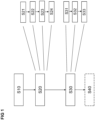
- a method for detecting feature points in an image which allows to find meaningful feature points belonging to static objects and, furthermore, to filter out a large number of meaningless feature points is explained in the following with reference to Figure 1 illustrating different steps of the method.
- the method may be executed by or within a vehicle, e.g. a car.
- a 3D model of a scene may be generated from a mobile entity, for example a vehicle, which is moving through the scene.
- the 3D model is construed as a 3D point cloud.
- the 3D point cloud may be embodied as a semi-dense or dense point cloud.
- the semi-dense or dense point cloud may be generated by conventional methods, for example VO (Visual Odometry) or a SLAM (Simultaneously Localization and Mapping) techniques in the mobile entity.
- the mobile entity may comprise an environmental sensor unit which collects information about the environment of a path along which the mobile entity is moving or about the environment in which the mobile entity is located.
- the mobile entity is configured to generate the 3D point cloud by evaluating a plurality of 2D images which may be captured by a camera of the sensor unit or by evaluating data from other sensors of the vehicle.
- a subsequent step S20 the 3D point cloud is evaluated.
- the possible evaluation steps are described below in detail.
- feature points are detected in the scene based on the evaluation of the 3D point cloud.
- the detected feature points may be reported to a server for further processing.
- a segmentation which may be a semantic segmentation and/or a segmentation by a neural network is performed of the 3D point cloud to obtain a segmented 3D point cloud including a plurality of 3D points.
- the semantic segmentation may be based on clusters which allow to differentiate individual objects that the clusters may be referring to.
- An embodiment of the semantic segmentation, the 3D point cloud, for example the semi-dense/dense point cloud may be evaluating by a deep learning network to recognize static objects. As a result, it may be detected that a cluster of 3D points represents a static object in the scene.
- a sub-step S22 of step S20 at least a portion of the 3D points of the segmented 3D point cloud is projected to at least one of the plurality of the 2D images.
- the portion of the 3D points to be projected to the 2D image may be selected such that the selected 3D points are associated to a static object in the scene. This step allows to filter out meaningless feature points from further processing.
- a grid of the 2D image is created.
- the grid includes a plurality of cells, wherein each of the cells includes a plurality of pixels.
- Each cell in the grid may be of size N x N pixels or N x M pixels, where N and M are positive integers.
- the feature points may be detected in the 2D image.
- the number of the projected 3D points included in each of the cells of the grid of the 2D image is counted.
- it may be evaluated how many of the evaluated 3D points are in a cell of the grid.
- One of the cells to be included in the portion of the cells for detecting the feature points is selected, if the count of projected 3D points of the respective cell is above a threshold value. If it is detected that the 3D points included within one of the cells of the grid has a predefined density or a predefined count, the respective cell may be marked as an active cell.
- the feature points are detected for the portion of the cells being selected in step S24, i.e. for the cells marked as active.
- the feature points may be generated at the positions of the selected/actively marked cells of the 2D image.
- the feature points may be salient points in the 2D image which may be characterized by feature point descriptors.
- the feature point descriptors may be mathematical descriptions of the characteristics of a region in the 2D image, i.e. in the selected cell/the selected set of pixels.
- Feature point descriptors may be largely agnostic to distance and viewing angle/camera pose. They may include information about the rotational and translational behaviour of an image region that includes the feature point.
- the 3D point cloud may be linked with the feature points detected in the 2D image.
- an identifier (ID) may be assigned for the 3D point cloud to be linked with the detected feature points.
- the detected feature points along with the point cloud information of the 3D point cloud may be reported to a server for further processing.
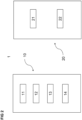
- Figure 2 illustrates a system 1 for generating optimized feature points of a scene in which a mobile entity is located.
- the system 1 includes a mobile entity 10 for detecting feature points in the scene.
- the mobile entity 10 includes an environmental sensor unit 11 to scan an environmental scene of the mobile entity 10.
- the environmental sensor unit 11 may further include a camera system like a CCD camera which may be suitable for capturing 2D visible and/or infrared images. Further sensors like a radar sensor, a laser sensor, an RF channel sensor or an infrared sensor may be used for scanning the environment of the mobile entity to generate the 3D point cloud.
- the mobile entity further may include a storage unit 12 to store at least one of the generated 2D images and/or the generated 3D model of the environmental scene, and it may include a processor unit 13.
- the processor unit 13 may be configured to execute instructions which, when executed by the processor unit 13 in cooperation with the storage unit 12, perform the various processing steps of the method for detecting the feature points in the scene as described above.
- the system 1 for generating optimized feature points of the scene further may include a remote server 20 to be in communication with the mobile entity 10.
- the remote server 20 may include a processor unit 21 and a storage unit 22 for storing a plurality of sets of feature points of the scene received from a plurality of other mobile entities which are, or have been, located in the same scene as the mobile entity 10.
- the mobile entity 10 may report the detected feature points along with the point cloud information of the 3D point cloud to the remote server 20.
- the processor unit 21 of the remote server may be configured to merge the feature points received from the mobile entity 10 along with the point cloud information of the 3D point cloud and the feature points along with their respective point cloud information of the 3D point cloud stored in the storage unit 21 from the other mobile entities to generate the optimized feature points of the scene.
- FIG 3 an image including multiple semi-dense 3D point clouds is shown.
- a first set of point clouds is formed by the features of a road 100, like the borders and the dashed center line.
- a further point cloud 110 is formed by a sign bridge 110.
- Another point cloud is based on a tree 120.
Landscapes
- Engineering & Computer Science (AREA)
- Physics & Mathematics (AREA)
- General Physics & Mathematics (AREA)
- Theoretical Computer Science (AREA)
- Radar, Positioning & Navigation (AREA)
- Remote Sensing (AREA)
- Multimedia (AREA)
- Data Mining & Analysis (AREA)
- Automation & Control Theory (AREA)
- Life Sciences & Earth Sciences (AREA)
- Artificial Intelligence (AREA)
- Bioinformatics & Cheminformatics (AREA)
- Bioinformatics & Computational Biology (AREA)
- Computer Vision & Pattern Recognition (AREA)
- Evolutionary Biology (AREA)
- Evolutionary Computation (AREA)
- General Engineering & Computer Science (AREA)
- Image Analysis (AREA)
Claims (10)
- Verfahren zum Erkennen von mit statischen Objekten in einem Bild assoziierten Merkmalspunkten, wobei das Verfahren Folgendes beinhaltet:- Erzeugen (S10) mindestens einer 3D-Punktwolke auf der Basis von mehreren 2D-Bildern von einer sich bewegenden monokularen Kamera,- Durchführen (S21) einer semantischen Segmentierung der 3D-Punktwolke, um eine segmentierte 3D-Punktwolke zu erhalten,- Auswählen von mit statischen Objekten assoziierten 3D-Punkten der segmentierten 3D-Punktwolke,- Projizieren (S22) der ausgewählten 3D-Punkte auf mindestens eines der mehreren 2D-Bilder,- Erkennen von Merkmalspunkten innerhalb des 2D-Bildes, das projizierte 3D-Punkte enthält,dadurch gekennzeichnet, dass der Schritt des Erkennens der Merkmalspunkte innerhalb des 2D-Bildes Folgendes beinhaltet:- Erzeugen (S23) eines Gitters des 2D-Bildes, das projizierte 3D-Punkte enthält, wobei das Gitter mehrere Zellen enthält, wobei jede der Zellen mehrere Pixel enthält,- Zählen (S24) der in jeder der Zellen enthaltenen projizierten 3D-Punkte, Auswerten der 3D-Punktwolke, und- Erkennen (S31) für eine Anzahl von Zellen, bei denen die Anzahl der projizierten 3D-Punkte der Zelle einen Schwellenwert überschreitet, von Merkmalspunkten innerhalb dieser Zelle.
- Verfahren nach Anspruch 1, wobei die Segmentierung auf Clustern basiert.
- Verfahren nach einem der vorherigen Ansprüche, das ferner Folgendes beinhaltet:
Verknüpfen (S32) der 3D-Punktwolke mit den erkannten Merkmalspunkten nach dem Erkennen der Merkmalspunkte. - Verfahren nach Anspruch 3, das ferner Folgendes beinhaltet:
Zuweisen (S33) einer Kennung für die mit den erkannten Merkmalspunkten zu verknüpfende 3D-Punktwolke. - Verfahren nach Anspruch 3 oder 4, das ferner Folgendes beinhaltet:
Melden (S40) der erkannten Merkmalspunkte samt Punktwolkeninformationen der 3D-Punktwolke an einen entfernten Server (20) zur weiteren Verarbeitung. - Verfahren nach einem der vorherigen Ansprüche,
wobei die 3D-Punktwolke als halbdichte oder dichte Punktwolke ausgeführt ist. - Verfahren nach einem der vorherigen Ansprüche,
wobei das Erzeugen der mindestens einen 3D-Punktwolke das Verwendung von VO (Visual Odometry) oder SLAM (Simultaneous Localization and Mapping) beinhaltet. - Verfahren nach einem der vorherigen Ansprüche,
wobei die bewegliche Kamera eine Kamera eines Fahrzeugs ist. - Mobile Entität (10) zum Erkennen von mit statischen Objekten in einem Bild assoziierten Merkmalspunkten, die Folgendes umfasst:- mindestens eine Umgebungssensoreinheit (11), die zum Abtasten einer Umgebungsszene der mobilen Entität (10) und zum Erzeugen der mehreren 2D-Bilder konfiguriert ist,- eine Speichereinheit (12), die zum Speichern eines erzeugten 3D-Modells der Umgebungsszene der mobilen Entität (10) und/oder mindestens eines der 2D-Bilder konfiguriert ist, und- eine Prozessoreinheit (13) zum Ausführen von Befehlen, die bei Ausführung durch die Prozessoreinheit (13) in Zusammenarbeit mit der Speichereinheit (12) die Prozessoreinheit zum Durchführen des Verfahrens nach einem der Ansprüche 1 bis 8 veranlassen.
- System (1) zum Erzeugen optimierter Merkmalspunkte eines Bildes, das Folgendes umfasst:- die mobile Entität (10) nach Anspruch 9,- einen entfernten Server (20), der so konfiguriert ist, dass er mit der mobilen Entität (10) in Verbindung steht, wobei der entfernte Server (20) eine Prozessoreinheit (21) und eine Speichereinheit (22) zum Speichern mehrerer von mehreren anderen mobilen Entitäten empfangener Sätze von Merkmalspunkten der Szene umfasst,- wobei die mobile Einheit (10) ein Kommunikationssystem (14) zum Übertragen der erkannten Merkmalspunkte samt Punktwolkeninformationen der 3D-Punktwolke zu dem entfernten Server (20) umfasst, und- wobei die Prozessoreinheit (21) zum Zusammenführen der Merkmalspunkte samt den von der mobilen Entität (10) empfangenen Punktwolkeninformationen der 3D-Punktwolke und der Merkmalspunkte samt in der Speichereinheit (21) gespeicherter Punktwolkeninformationen der 3D-Punktwolke der anderen mobilen Einheiten konfiguriert ist, um die optimierten Merkmalspunkte der Szene zu erzeugen.
Applications Claiming Priority (2)
| Application Number | Priority Date | Filing Date | Title |
|---|---|---|---|
| DE102019209990 | 2019-07-08 | ||
| PCT/EP2020/068024 WO2021004813A1 (en) | 2019-07-08 | 2020-06-26 | Method and mobile entity for detecting feature points in an image |
Publications (2)
| Publication Number | Publication Date |
|---|---|
| EP4078087A1 EP4078087A1 (de) | 2022-10-26 |
| EP4078087B1 true EP4078087B1 (de) | 2024-05-01 |
Family
ID=71143754
Family Applications (1)
| Application Number | Title | Priority Date | Filing Date |
|---|---|---|---|
| EP20734743.6A Active EP4078087B1 (de) | 2019-07-08 | 2020-06-26 | Verfahren und mobile einheit zur erkennung von merkmalspunkten auf einem bild |
Country Status (2)
| Country | Link |
|---|---|
| EP (1) | EP4078087B1 (de) |
| WO (1) | WO2021004813A1 (de) |
Families Citing this family (3)
| Publication number | Priority date | Publication date | Assignee | Title |
|---|---|---|---|---|
| CN114140470A (zh) * | 2021-12-07 | 2022-03-04 | 群周科技(上海)有限公司 | 一种基于直升机机载激光雷达的地物语义分割方法 |
| WO2023220987A1 (zh) * | 2022-05-18 | 2023-11-23 | 北京小米移动软件有限公司 | 目标点确定方法、装置、电子设备及存储介质 |
| CN116381713A (zh) * | 2023-04-06 | 2023-07-04 | 吉林大学 | 一种多传感器点云融合的动态场景自主定位与建图方法 |
Family Cites Families (1)
| Publication number | Priority date | Publication date | Assignee | Title |
|---|---|---|---|---|
| GB2520338A (en) * | 2013-11-19 | 2015-05-20 | Nokia Corp | Automatic scene parsing |
-
2020
- 2020-06-26 EP EP20734743.6A patent/EP4078087B1/de active Active
- 2020-06-26 WO PCT/EP2020/068024 patent/WO2021004813A1/en not_active Ceased
Also Published As
| Publication number | Publication date |
|---|---|
| EP4078087A1 (de) | 2022-10-26 |
| WO2021004813A1 (en) | 2021-01-14 |
Similar Documents
| Publication | Publication Date | Title |
|---|---|---|
| JP7485749B2 (ja) | ビデオベースの位置決め及びマッピングの方法及びシステム | |
| CN110988912B (zh) | 自动驾驶车辆的道路目标与距离检测方法、系统、装置 | |
| CN110221603B (zh) | 一种基于激光雷达多帧点云融合的远距离障碍物检测方法 | |
| CN112346463B (zh) | 一种基于速度采样的无人车路径规划方法 | |
| Shinzato et al. | Road terrain detection: Avoiding common obstacle detection assumptions using sensor fusion | |
| CN115273034A (zh) | 一种基于车载多传感器融合的交通目标检测与跟踪方法 | |
| Broggi et al. | Terramax vision at the urban challenge 2007 | |
| CN112464812A (zh) | 一种基于车辆的凹陷类障碍物检测方法 | |
| CN113240734B (zh) | 一种基于鸟瞰图的车辆跨位判断方法、装置、设备及介质 | |
| US20230266473A1 (en) | Method and system for object detection for a mobile robot with time-of-flight camera | |
| CN116385997A (zh) | 一种车载障碍物精确感知方法、系统及存储介质 | |
| EP4078087B1 (de) | Verfahren und mobile einheit zur erkennung von merkmalspunkten auf einem bild | |
| TW202430840A (zh) | 路徑規劃系統及其路徑規劃方法 | |
| Nuss et al. | Fusion of laser and monocular camera data in object grid maps for vehicle environment perception | |
| CN115371673A (zh) | 一种未知环境中基于Bundle Adjustment的双目相机目标定位方法 | |
| US20240127603A1 (en) | Unified framework and tooling for lane boundary annotation | |
| Muresan et al. | Real-time object detection using a sparse 4-layer LIDAR | |
| Gálai et al. | Crossmodal point cloud registration in the Hough space for mobile laser scanning data | |
| CN112907659B (zh) | 移动设备定位系统、方法及设备 | |
| CN118865310A (zh) | 目标对象的检测方法及目标对象检测模型的训练方法 | |
| Majdik et al. | Micro air vehicle localization and position tracking from textured 3d cadastral models | |
| Pauls et al. | Automatic mapping of tailored landmark representations for automated driving and map learning | |
| KR20220151572A (ko) | IPM 이미지와 정밀도로지도(HD Map) 피팅을 통해 노면객체의 변화를 자동으로 판단하고 갱신하는 정밀도로지도 자동갱신 방법 및 시스템 | |
| Christie et al. | Semantics for UGV Registration in GPS-denied Environments | |
| Yabuuchi et al. | VMVG-Loc: Visual localization for autonomous driving using vector map and voxel grid map |
Legal Events
| Date | Code | Title | Description |
|---|---|---|---|
| STAA | Information on the status of an ep patent application or granted ep patent |
Free format text: STATUS: UNKNOWN |
|
| STAA | Information on the status of an ep patent application or granted ep patent |
Free format text: STATUS: THE INTERNATIONAL PUBLICATION HAS BEEN MADE |
|
| PUAI | Public reference made under article 153(3) epc to a published international application that has entered the european phase |
Free format text: ORIGINAL CODE: 0009012 |
|
| STAA | Information on the status of an ep patent application or granted ep patent |
Free format text: STATUS: REQUEST FOR EXAMINATION WAS MADE |
|
| 17P | Request for examination filed |
Effective date: 20220509 |
|
| AK | Designated contracting states |
Kind code of ref document: A1 Designated state(s): AL AT BE BG CH CY CZ DE DK EE ES FI FR GB GR HR HU IE IS IT LI LT LU LV MC MK MT NL NO PL PT RO RS SE SI SK SM TR |
|
| RIC1 | Information provided on ipc code assigned before grant |
Ipc: G01C 21/00 20060101AFI20231005BHEP |
|
| GRAP | Despatch of communication of intention to grant a patent |
Free format text: ORIGINAL CODE: EPIDOSNIGR1 |
|
| STAA | Information on the status of an ep patent application or granted ep patent |
Free format text: STATUS: GRANT OF PATENT IS INTENDED |
|
| INTG | Intention to grant announced |
Effective date: 20231128 |
|
| GRAS | Grant fee paid |
Free format text: ORIGINAL CODE: EPIDOSNIGR3 |
|
| GRAA | (expected) grant |
Free format text: ORIGINAL CODE: 0009210 |
|
| STAA | Information on the status of an ep patent application or granted ep patent |
Free format text: STATUS: THE PATENT HAS BEEN GRANTED |
|
| AK | Designated contracting states |
Kind code of ref document: B1 Designated state(s): AL AT BE BG CH CY CZ DE DK EE ES FI FR GB GR HR HU IE IS IT LI LT LU LV MC MK MT NL NO PL PT RO RS SE SI SK SM TR |
|
| REG | Reference to a national code |
Ref country code: GB Ref legal event code: FG4D |
|
| REG | Reference to a national code |
Ref country code: CH Ref legal event code: EP |
|
| REG | Reference to a national code |
Ref country code: IE Ref legal event code: FG4D |
|
| REG | Reference to a national code |
Ref country code: DE Ref legal event code: R096 Ref document number: 602020030159 Country of ref document: DE |
|
| 111L | Licence recorded |
Designated state(s): AL AT BE BG CH CY CZ DE DK EE ES FI FR GB GR HR HU IE IS IT LT LU LV MC MK MT NL NO PL PT RO RS SE SI SK SM TR Free format text: EXCLUSIVE LICENSE Name of requester: QUALCOMM TECHNOLOGIES, INC., US Effective date: 20231103 |
|
| REG | Reference to a national code |
Ref country code: LT Ref legal event code: MG9D |
|
| REG | Reference to a national code |
Ref country code: NL Ref legal event code: MP Effective date: 20240501 |
|
| PG25 | Lapsed in a contracting state [announced via postgrant information from national office to epo] |
Ref country code: IS Free format text: LAPSE BECAUSE OF FAILURE TO SUBMIT A TRANSLATION OF THE DESCRIPTION OR TO PAY THE FEE WITHIN THE PRESCRIBED TIME-LIMIT Effective date: 20240901 |
|
| PG25 | Lapsed in a contracting state [announced via postgrant information from national office to epo] |
Ref country code: BG Free format text: LAPSE BECAUSE OF FAILURE TO SUBMIT A TRANSLATION OF THE DESCRIPTION OR TO PAY THE FEE WITHIN THE PRESCRIBED TIME-LIMIT Effective date: 20240501 |
|
| PG25 | Lapsed in a contracting state [announced via postgrant information from national office to epo] |
Ref country code: HR Free format text: LAPSE BECAUSE OF FAILURE TO SUBMIT A TRANSLATION OF THE DESCRIPTION OR TO PAY THE FEE WITHIN THE PRESCRIBED TIME-LIMIT Effective date: 20240501 Ref country code: FI Free format text: LAPSE BECAUSE OF FAILURE TO SUBMIT A TRANSLATION OF THE DESCRIPTION OR TO PAY THE FEE WITHIN THE PRESCRIBED TIME-LIMIT Effective date: 20240501 |
|
| PG25 | Lapsed in a contracting state [announced via postgrant information from national office to epo] |
Ref country code: GR Free format text: LAPSE BECAUSE OF FAILURE TO SUBMIT A TRANSLATION OF THE DESCRIPTION OR TO PAY THE FEE WITHIN THE PRESCRIBED TIME-LIMIT Effective date: 20240802 |
|
| PG25 | Lapsed in a contracting state [announced via postgrant information from national office to epo] |
Ref country code: PT Free format text: LAPSE BECAUSE OF FAILURE TO SUBMIT A TRANSLATION OF THE DESCRIPTION OR TO PAY THE FEE WITHIN THE PRESCRIBED TIME-LIMIT Effective date: 20240902 |
|
| REG | Reference to a national code |
Ref country code: AT Ref legal event code: MK05 Ref document number: 1682907 Country of ref document: AT Kind code of ref document: T Effective date: 20240501 |
|
| PG25 | Lapsed in a contracting state [announced via postgrant information from national office to epo] |
Ref country code: NL Free format text: LAPSE BECAUSE OF FAILURE TO SUBMIT A TRANSLATION OF THE DESCRIPTION OR TO PAY THE FEE WITHIN THE PRESCRIBED TIME-LIMIT Effective date: 20240501 |
|
| PG25 | Lapsed in a contracting state [announced via postgrant information from national office to epo] |
Ref country code: ES Free format text: LAPSE BECAUSE OF FAILURE TO SUBMIT A TRANSLATION OF THE DESCRIPTION OR TO PAY THE FEE WITHIN THE PRESCRIBED TIME-LIMIT Effective date: 20240501 |
|
| PG25 | Lapsed in a contracting state [announced via postgrant information from national office to epo] |
Ref country code: AT Free format text: LAPSE BECAUSE OF FAILURE TO SUBMIT A TRANSLATION OF THE DESCRIPTION OR TO PAY THE FEE WITHIN THE PRESCRIBED TIME-LIMIT Effective date: 20240501 |
|
| PG25 | Lapsed in a contracting state [announced via postgrant information from national office to epo] |
Ref country code: PL Free format text: LAPSE BECAUSE OF FAILURE TO SUBMIT A TRANSLATION OF THE DESCRIPTION OR TO PAY THE FEE WITHIN THE PRESCRIBED TIME-LIMIT Effective date: 20240501 |
|
| PG25 | Lapsed in a contracting state [announced via postgrant information from national office to epo] |
Ref country code: LV Free format text: LAPSE BECAUSE OF FAILURE TO SUBMIT A TRANSLATION OF THE DESCRIPTION OR TO PAY THE FEE WITHIN THE PRESCRIBED TIME-LIMIT Effective date: 20240501 |
|
| PG25 | Lapsed in a contracting state [announced via postgrant information from national office to epo] |
Ref country code: PT Free format text: LAPSE BECAUSE OF FAILURE TO SUBMIT A TRANSLATION OF THE DESCRIPTION OR TO PAY THE FEE WITHIN THE PRESCRIBED TIME-LIMIT Effective date: 20240902 Ref country code: PL Free format text: LAPSE BECAUSE OF FAILURE TO SUBMIT A TRANSLATION OF THE DESCRIPTION OR TO PAY THE FEE WITHIN THE PRESCRIBED TIME-LIMIT Effective date: 20240501 Ref country code: NO Free format text: LAPSE BECAUSE OF FAILURE TO SUBMIT A TRANSLATION OF THE DESCRIPTION OR TO PAY THE FEE WITHIN THE PRESCRIBED TIME-LIMIT Effective date: 20240801 Ref country code: NL Free format text: LAPSE BECAUSE OF FAILURE TO SUBMIT A TRANSLATION OF THE DESCRIPTION OR TO PAY THE FEE WITHIN THE PRESCRIBED TIME-LIMIT Effective date: 20240501 Ref country code: LV Free format text: LAPSE BECAUSE OF FAILURE TO SUBMIT A TRANSLATION OF THE DESCRIPTION OR TO PAY THE FEE WITHIN THE PRESCRIBED TIME-LIMIT Effective date: 20240501 Ref country code: IS Free format text: LAPSE BECAUSE OF FAILURE TO SUBMIT A TRANSLATION OF THE DESCRIPTION OR TO PAY THE FEE WITHIN THE PRESCRIBED TIME-LIMIT Effective date: 20240901 Ref country code: HR Free format text: LAPSE BECAUSE OF FAILURE TO SUBMIT A TRANSLATION OF THE DESCRIPTION OR TO PAY THE FEE WITHIN THE PRESCRIBED TIME-LIMIT Effective date: 20240501 Ref country code: GR Free format text: LAPSE BECAUSE OF FAILURE TO SUBMIT A TRANSLATION OF THE DESCRIPTION OR TO PAY THE FEE WITHIN THE PRESCRIBED TIME-LIMIT Effective date: 20240802 Ref country code: FI Free format text: LAPSE BECAUSE OF FAILURE TO SUBMIT A TRANSLATION OF THE DESCRIPTION OR TO PAY THE FEE WITHIN THE PRESCRIBED TIME-LIMIT Effective date: 20240501 Ref country code: ES Free format text: LAPSE BECAUSE OF FAILURE TO SUBMIT A TRANSLATION OF THE DESCRIPTION OR TO PAY THE FEE WITHIN THE PRESCRIBED TIME-LIMIT Effective date: 20240501 Ref country code: BG Free format text: LAPSE BECAUSE OF FAILURE TO SUBMIT A TRANSLATION OF THE DESCRIPTION OR TO PAY THE FEE WITHIN THE PRESCRIBED TIME-LIMIT Effective date: 20240501 Ref country code: AT Free format text: LAPSE BECAUSE OF FAILURE TO SUBMIT A TRANSLATION OF THE DESCRIPTION OR TO PAY THE FEE WITHIN THE PRESCRIBED TIME-LIMIT Effective date: 20240501 Ref country code: RS Free format text: LAPSE BECAUSE OF FAILURE TO SUBMIT A TRANSLATION OF THE DESCRIPTION OR TO PAY THE FEE WITHIN THE PRESCRIBED TIME-LIMIT Effective date: 20240801 |
|
| PG25 | Lapsed in a contracting state [announced via postgrant information from national office to epo] |
Ref country code: DK Free format text: LAPSE BECAUSE OF FAILURE TO SUBMIT A TRANSLATION OF THE DESCRIPTION OR TO PAY THE FEE WITHIN THE PRESCRIBED TIME-LIMIT Effective date: 20240501 |
|
| PG25 | Lapsed in a contracting state [announced via postgrant information from national office to epo] |
Ref country code: EE Free format text: LAPSE BECAUSE OF FAILURE TO SUBMIT A TRANSLATION OF THE DESCRIPTION OR TO PAY THE FEE WITHIN THE PRESCRIBED TIME-LIMIT Effective date: 20240501 |
|
| PG25 | Lapsed in a contracting state [announced via postgrant information from national office to epo] |
Ref country code: CZ Free format text: LAPSE BECAUSE OF FAILURE TO SUBMIT A TRANSLATION OF THE DESCRIPTION OR TO PAY THE FEE WITHIN THE PRESCRIBED TIME-LIMIT Effective date: 20240501 |
|
| PG25 | Lapsed in a contracting state [announced via postgrant information from national office to epo] |
Ref country code: SK Free format text: LAPSE BECAUSE OF FAILURE TO SUBMIT A TRANSLATION OF THE DESCRIPTION OR TO PAY THE FEE WITHIN THE PRESCRIBED TIME-LIMIT Effective date: 20240501 Ref country code: RO Free format text: LAPSE BECAUSE OF FAILURE TO SUBMIT A TRANSLATION OF THE DESCRIPTION OR TO PAY THE FEE WITHIN THE PRESCRIBED TIME-LIMIT Effective date: 20240501 |
|
| PG25 | Lapsed in a contracting state [announced via postgrant information from national office to epo] |
Ref country code: SM Free format text: LAPSE BECAUSE OF FAILURE TO SUBMIT A TRANSLATION OF THE DESCRIPTION OR TO PAY THE FEE WITHIN THE PRESCRIBED TIME-LIMIT Effective date: 20240501 |
|
| PG25 | Lapsed in a contracting state [announced via postgrant information from national office to epo] |
Ref country code: SM Free format text: LAPSE BECAUSE OF FAILURE TO SUBMIT A TRANSLATION OF THE DESCRIPTION OR TO PAY THE FEE WITHIN THE PRESCRIBED TIME-LIMIT Effective date: 20240501 Ref country code: SK Free format text: LAPSE BECAUSE OF FAILURE TO SUBMIT A TRANSLATION OF THE DESCRIPTION OR TO PAY THE FEE WITHIN THE PRESCRIBED TIME-LIMIT Effective date: 20240501 Ref country code: RO Free format text: LAPSE BECAUSE OF FAILURE TO SUBMIT A TRANSLATION OF THE DESCRIPTION OR TO PAY THE FEE WITHIN THE PRESCRIBED TIME-LIMIT Effective date: 20240501 Ref country code: EE Free format text: LAPSE BECAUSE OF FAILURE TO SUBMIT A TRANSLATION OF THE DESCRIPTION OR TO PAY THE FEE WITHIN THE PRESCRIBED TIME-LIMIT Effective date: 20240501 Ref country code: DK Free format text: LAPSE BECAUSE OF FAILURE TO SUBMIT A TRANSLATION OF THE DESCRIPTION OR TO PAY THE FEE WITHIN THE PRESCRIBED TIME-LIMIT Effective date: 20240501 Ref country code: CZ Free format text: LAPSE BECAUSE OF FAILURE TO SUBMIT A TRANSLATION OF THE DESCRIPTION OR TO PAY THE FEE WITHIN THE PRESCRIBED TIME-LIMIT Effective date: 20240501 Ref country code: MC Free format text: LAPSE BECAUSE OF FAILURE TO SUBMIT A TRANSLATION OF THE DESCRIPTION OR TO PAY THE FEE WITHIN THE PRESCRIBED TIME-LIMIT Effective date: 20240501 |
|
| REG | Reference to a national code |
Ref country code: CH Ref legal event code: PL |
|
| REG | Reference to a national code |
Ref country code: DE Ref legal event code: R097 Ref document number: 602020030159 Country of ref document: DE |
|
| PG25 | Lapsed in a contracting state [announced via postgrant information from national office to epo] |
Ref country code: IT Free format text: LAPSE BECAUSE OF FAILURE TO SUBMIT A TRANSLATION OF THE DESCRIPTION OR TO PAY THE FEE WITHIN THE PRESCRIBED TIME-LIMIT Effective date: 20240501 |
|
| PG25 | Lapsed in a contracting state [announced via postgrant information from national office to epo] |
Ref country code: LU Free format text: LAPSE BECAUSE OF NON-PAYMENT OF DUE FEES Effective date: 20240626 |
|
| PLBE | No opposition filed within time limit |
Free format text: ORIGINAL CODE: 0009261 |
|
| STAA | Information on the status of an ep patent application or granted ep patent |
Free format text: STATUS: NO OPPOSITION FILED WITHIN TIME LIMIT |
|
| REG | Reference to a national code |
Ref country code: DE Ref legal event code: R081 Ref document number: 602020030159 Country of ref document: DE Owner name: CONTINENTAL AUTOMOTIVE TECHNOLOGIES GMBH, DE Free format text: FORMER OWNER: CONTINENTAL AUTOMOTIVE GMBH, 30165 HANNOVER, DE Ref country code: DE Ref legal event code: R081 Ref document number: 602020030159 Country of ref document: DE Owner name: AUMOVIO GERMANY GMBH, DE Free format text: FORMER OWNER: CONTINENTAL AUTOMOTIVE GMBH, 30165 HANNOVER, DE |
|
| 26N | No opposition filed |
Effective date: 20250204 |
|
| PG25 | Lapsed in a contracting state [announced via postgrant information from national office to epo] |
Ref country code: IE Free format text: LAPSE BECAUSE OF NON-PAYMENT OF DUE FEES Effective date: 20240626 |
|
| PG25 | Lapsed in a contracting state [announced via postgrant information from national office to epo] |
Ref country code: SI Free format text: LAPSE BECAUSE OF FAILURE TO SUBMIT A TRANSLATION OF THE DESCRIPTION OR TO PAY THE FEE WITHIN THE PRESCRIBED TIME-LIMIT Effective date: 20240501 Ref country code: BE Free format text: LAPSE BECAUSE OF NON-PAYMENT OF DUE FEES Effective date: 20240630 Ref country code: CH Free format text: LAPSE BECAUSE OF NON-PAYMENT OF DUE FEES Effective date: 20240630 |
|
| REG | Reference to a national code |
Ref country code: BE Ref legal event code: MM Effective date: 20240630 |
|
| PGFP | Annual fee paid to national office [announced via postgrant information from national office to epo] |
Ref country code: DE Payment date: 20250509 Year of fee payment: 6 |
|
| PGFP | Annual fee paid to national office [announced via postgrant information from national office to epo] |
Ref country code: GB Payment date: 20250508 Year of fee payment: 6 |
|
| PGFP | Annual fee paid to national office [announced via postgrant information from national office to epo] |
Ref country code: FR Payment date: 20250512 Year of fee payment: 6 |
|
| PG25 | Lapsed in a contracting state [announced via postgrant information from national office to epo] |
Ref country code: SE Free format text: LAPSE BECAUSE OF FAILURE TO SUBMIT A TRANSLATION OF THE DESCRIPTION OR TO PAY THE FEE WITHIN THE PRESCRIBED TIME-LIMIT Effective date: 20240501 |
|
| PG25 | Lapsed in a contracting state [announced via postgrant information from national office to epo] |
Ref country code: CY Free format text: LAPSE BECAUSE OF FAILURE TO SUBMIT A TRANSLATION OF THE DESCRIPTION OR TO PAY THE FEE WITHIN THE PRESCRIBED TIME-LIMIT; INVALID AB INITIO Effective date: 20200626 |
|
| REG | Reference to a national code |
Ref country code: GB Ref legal event code: 732E Free format text: REGISTERED BETWEEN 20251204 AND 20251210 |
|
| REG | Reference to a national code |
Ref country code: DE Ref legal event code: R081 Ref document number: 602020030159 Country of ref document: DE Owner name: AUMOVIO GERMANY GMBH, DE Free format text: FORMER OWNER: CONTINENTAL AUTOMOTIVE TECHNOLOGIES GMBH, 30175 HANNOVER, DE |
|
| PG25 | Lapsed in a contracting state [announced via postgrant information from national office to epo] |
Ref country code: HU Free format text: LAPSE BECAUSE OF FAILURE TO SUBMIT A TRANSLATION OF THE DESCRIPTION OR TO PAY THE FEE WITHIN THE PRESCRIBED TIME-LIMIT; INVALID AB INITIO Effective date: 20200626 |