EP4064006A1 - Identifizierung eines ortes von interesse auf einem physikalischen objekt durch dessen 3d-modell in der ansicht mit erweiterter realität - Google Patents
Identifizierung eines ortes von interesse auf einem physikalischen objekt durch dessen 3d-modell in der ansicht mit erweiterter realität Download PDFInfo
- Publication number
- EP4064006A1 EP4064006A1 EP21163948.9A EP21163948A EP4064006A1 EP 4064006 A1 EP4064006 A1 EP 4064006A1 EP 21163948 A EP21163948 A EP 21163948A EP 4064006 A1 EP4064006 A1 EP 4064006A1
- Authority
- EP
- European Patent Office
- Prior art keywords
- interest
- physical object
- place
- model
- user
- Prior art date
- Legal status (The legal status is an assumption and is not a legal conclusion. Google has not performed a legal analysis and makes no representation as to the accuracy of the status listed.)
- Withdrawn
Links
Images


Classifications
-
- G—PHYSICS
- G06—COMPUTING OR CALCULATING; COUNTING
- G06T—IMAGE DATA PROCESSING OR GENERATION, IN GENERAL
- G06T19/00—Manipulating 3D models or images for computer graphics
- G06T19/006—Mixed reality
-
- G—PHYSICS
- G05—CONTROLLING; REGULATING
- G05B—CONTROL OR REGULATING SYSTEMS IN GENERAL; FUNCTIONAL ELEMENTS OF SUCH SYSTEMS; MONITORING OR TESTING ARRANGEMENTS FOR SUCH SYSTEMS OR ELEMENTS
- G05B19/00—Programme-control systems
- G05B19/02—Programme-control systems electric
- G05B19/04—Programme control other than numerical control, i.e. in sequence controllers or logic controllers
- G05B19/042—Programme control other than numerical control, i.e. in sequence controllers or logic controllers using digital processors
- G05B19/0426—Programming the control sequence
-
- G—PHYSICS
- G06—COMPUTING OR CALCULATING; COUNTING
- G06F—ELECTRIC DIGITAL DATA PROCESSING
- G06F3/00—Input arrangements for transferring data to be processed into a form capable of being handled by the computer; Output arrangements for transferring data from processing unit to output unit, e.g. interface arrangements
- G06F3/01—Input arrangements or combined input and output arrangements for interaction between user and computer
- G06F3/011—Arrangements for interaction with the human body, e.g. for user immersion in virtual reality
-
- G—PHYSICS
- G06—COMPUTING OR CALCULATING; COUNTING
- G06F—ELECTRIC DIGITAL DATA PROCESSING
- G06F3/00—Input arrangements for transferring data to be processed into a form capable of being handled by the computer; Output arrangements for transferring data from processing unit to output unit, e.g. interface arrangements
- G06F3/01—Input arrangements or combined input and output arrangements for interaction between user and computer
- G06F3/017—Gesture based interaction, e.g. based on a set of recognized hand gestures
-
- G—PHYSICS
- G06—COMPUTING OR CALCULATING; COUNTING
- G06Q—INFORMATION AND COMMUNICATION TECHNOLOGY [ICT] SPECIALLY ADAPTED FOR ADMINISTRATIVE, COMMERCIAL, FINANCIAL, MANAGERIAL OR SUPERVISORY PURPOSES; SYSTEMS OR METHODS SPECIALLY ADAPTED FOR ADMINISTRATIVE, COMMERCIAL, FINANCIAL, MANAGERIAL OR SUPERVISORY PURPOSES, NOT OTHERWISE PROVIDED FOR
- G06Q10/00—Administration; Management
- G06Q10/20—Administration of product repair or maintenance
-
- G—PHYSICS
- G06—COMPUTING OR CALCULATING; COUNTING
- G06V—IMAGE OR VIDEO RECOGNITION OR UNDERSTANDING
- G06V10/00—Arrangements for image or video recognition or understanding
- G06V10/20—Image preprocessing
- G06V10/25—Determination of region of interest [ROI] or a volume of interest [VOI]
-
- G—PHYSICS
- G06—COMPUTING OR CALCULATING; COUNTING
- G06V—IMAGE OR VIDEO RECOGNITION OR UNDERSTANDING
- G06V10/00—Arrangements for image or video recognition or understanding
- G06V10/20—Image preprocessing
- G06V10/26—Segmentation of patterns in the image field; Cutting or merging of image elements to establish the pattern region, e.g. clustering-based techniques; Detection of occlusion
-
- G—PHYSICS
- G06—COMPUTING OR CALCULATING; COUNTING
- G06V—IMAGE OR VIDEO RECOGNITION OR UNDERSTANDING
- G06V10/00—Arrangements for image or video recognition or understanding
- G06V10/94—Hardware or software architectures specially adapted for image or video understanding
-
- G—PHYSICS
- G06—COMPUTING OR CALCULATING; COUNTING
- G06V—IMAGE OR VIDEO RECOGNITION OR UNDERSTANDING
- G06V20/00—Scenes; Scene-specific elements
- G06V20/20—Scenes; Scene-specific elements in augmented reality scenes
-
- G—PHYSICS
- G06—COMPUTING OR CALCULATING; COUNTING
- G06V—IMAGE OR VIDEO RECOGNITION OR UNDERSTANDING
- G06V20/00—Scenes; Scene-specific elements
- G06V20/60—Type of objects
- G06V20/64—Three-dimensional objects
-
- G—PHYSICS
- G06—COMPUTING OR CALCULATING; COUNTING
- G06V—IMAGE OR VIDEO RECOGNITION OR UNDERSTANDING
- G06V40/00—Recognition of biometric, human-related or animal-related patterns in image or video data
- G06V40/10—Human or animal bodies, e.g. vehicle occupants or pedestrians; Body parts, e.g. hands
- G06V40/18—Eye characteristics, e.g. of the iris
- G06V40/19—Sensors therefor
-
- G—PHYSICS
- G06—COMPUTING OR CALCULATING; COUNTING
- G06V—IMAGE OR VIDEO RECOGNITION OR UNDERSTANDING
- G06V40/00—Recognition of biometric, human-related or animal-related patterns in image or video data
- G06V40/20—Movements or behaviour, e.g. gesture recognition
- G06V40/28—Recognition of hand or arm movements, e.g. recognition of deaf sign language
-
- G—PHYSICS
- G05—CONTROLLING; REGULATING
- G05B—CONTROL OR REGULATING SYSTEMS IN GENERAL; FUNCTIONAL ELEMENTS OF SUCH SYSTEMS; MONITORING OR TESTING ARRANGEMENTS FOR SUCH SYSTEMS OR ELEMENTS
- G05B2219/00—Program-control systems
- G05B2219/20—Pc systems
- G05B2219/23—Pc programming
- G05B2219/23182—3D display of controlled system
-
- G—PHYSICS
- G05—CONTROLLING; REGULATING
- G05B—CONTROL OR REGULATING SYSTEMS IN GENERAL; FUNCTIONAL ELEMENTS OF SUCH SYSTEMS; MONITORING OR TESTING ARRANGEMENTS FOR SUCH SYSTEMS OR ELEMENTS
- G05B2219/00—Program-control systems
- G05B2219/30—Nc systems
- G05B2219/32—Operator till task planning
- G05B2219/32014—Augmented reality assists operator in maintenance, repair, programming, assembly, use of head mounted display with 2-D 3-D display and voice feedback, voice and gesture command
-
- G—PHYSICS
- G06—COMPUTING OR CALCULATING; COUNTING
- G06T—IMAGE DATA PROCESSING OR GENERATION, IN GENERAL
- G06T2200/00—Indexing scheme for image data processing or generation, in general
- G06T2200/24—Indexing scheme for image data processing or generation, in general involving graphical user interfaces [GUIs]
-
- G—PHYSICS
- G06—COMPUTING OR CALCULATING; COUNTING
- G06T—IMAGE DATA PROCESSING OR GENERATION, IN GENERAL
- G06T2210/00—Indexing scheme for image generation or computer graphics
- G06T2210/62—Semi-transparency
-
- G—PHYSICS
- G06—COMPUTING OR CALCULATING; COUNTING
- G06T—IMAGE DATA PROCESSING OR GENERATION, IN GENERAL
- G06T2219/00—Indexing scheme for manipulating 3D models or images for computer graphics
- G06T2219/004—Annotating, labelling
Definitions
- the embodiments disclosed herein relate to a method for identifying at least one place of interest on a physical object within a physical environment, using augmented reality and a 3D model of the physical object.
- a corresponding computer program product and computer-readable storage are disclosed as well.
- Augmented Reality is one such technology which has been used to ease this process and make it more efficient and optimized.
- AR is an increasing trend in technology being used to perform industry related tasks in a factory site or similar environment.
- Embodiments herein generally relate to a method for identifying at least one place of interest on a physical object within a physical environment, using augmented reality and a 3D model of the physical object.
- the method including the steps of:
- a key element of the invention is to use at least one virtual proximity sensor and motion data of a user to determine an intersection point.
- the intersection point is used to determine the place of interest the user wants to select.
- Places of interest are any areas or parts of the physical object, especially a machine, object, etc., where the user needs to focus on, to perform a particular task. These POIs could be specific parts of the physical object or some special markings which need to be checked for correctness.
- the virtual proximity sensors are digital "sensors" capable of detecting proximity of intersection among 3D objects in a 3D scene in augmented reality.
- said at least one place of interest is identified directly in the augmented reality (AR) environment.
- AR augmented reality
- Preferred purposes are adding information, arranged to be shown to future users in AR, like instructions, explanations, or references to the identified places of interest or adding visual markers, like highlights, arrows, or lines, points to the identified places of interest. Further embodiments are disclosed in the following.
- the method comprising the further step of adapting a transparency of the 3D model.
- the 3D model needs to be transparent to blend the 3D model onto the physical object, especially to only see identifiers corresponding to places of interest. Therefore, the quick access of the transparency toggling feature is preferred.
- the method comprising the further step of acquiring image documentation and/or video documentation, the documentation and/or the video documentation being related to said at least one place of interest.
- protocoling media such as videos or photos taken from the device used for inspection. These can be either used to record training material or inspect with the help of pre-recorded material. This could also be for the use case, where a service technician needs to send a picture or video of the faulty or missing part on the machine. For this, a video/photo taking feature is preferred.
- the method comprising the further step of storing said at least one place of interest with the 3D model of the physical object.
- POI place of interest
- the technical problem that this invention solves with this embodiment is the modification of the POI.
- the user can intuitively touch the identifier and change its transformational values by moving, resizing, or changing its orientation.
- Associated 3D coordinates will change when the user moves the identifier.
- the rotational transforms also change when user orients the identifier to face up, down or sideways or at any angle that the user desires it to be.
- the POIs can also be manipulated to make it bigger or smaller and correspondingly the scale transforms on the POI will also be reflected.
- a 3D-depth sensor in the AR-device is used. This has the advantage that motion data, which can be interpreted as interaction data of a particular interaction with the physical object, can be collected in a 3D environment. The coordinates of the motion data can then be used in relation to coordinates of the physical object.
- the method comprising the further step of determining a position of the physical object within the physical environment using a spatial awareness technology, especially Simultaneous Localization and Mapping (SLAM) technology.
- SLAM Simultaneous Localization and Mapping
- This further step is performed before the aligning, in the augmented reality view of the 3D model, with the physical object, within the physical environment and after the step of identifying said at least one place of interest.
- Coordinates of said position of the one or more POI identified on a physical object are stored with a Simultaneous Localization and Mapping (SLAM) map.
- SLAM Simultaneous Localization and Mapping
- a spatial awareness system provides real-world environmental awareness in mixed reality applications.
- a known technology is SLAM Simultaneous Localization and Mapping which creates a 3D map of the environment scanned with the AR device (e.g. via cameras or lidar).
- Spatial Awareness provides a collection of meshes, representing the geometry of the environment, which allows for an AR application to place holograms in the real world and for compelling interactions between holograms and the real-world.
- the method comprising the further step of categorizing said at least one place of interest into a predefined category, wherein the categorizing is performed by including third motion data determined by tracking at least, one third gesture of a user related to the physical object.
- the invention addresses the technical problem to fine tune the focus of the service technician, to further concentrate on specific identifiers. These could be particularly useful when there are different steps to the process of completing the task, and one wants to only show the identifiers related to that step.
- the method of the invention offers both categorization without coding and direct validation in an AR app itself, which makes it quick and easy without iterations.
- the user interaction with an app according to the invention is also intuitive, which means no extensive learning modules of the software or coding is required to categorize identifiers.
- the method comprising the further step of labelling said at least one place of interest using an identifier.
- Identifiers have the advantage that they can be used to label a place of interest. Identifiers, after adding them, can be used to select a place of interest by the user or to add some further information to a place of interest.
- the method comprising the further step of adding instructional data to said at least one place of interest, the instructional data being part of the 3D model.
- the instructional data can be added to the physical object and/or said at least one place of interest.
- This instructional data can be shown to future users.
- the instructional data can preferably be arranged as a manual, a training video, or an information sheet.
- This app will help to complete tasks in different use-cases, especially the above-mentioned use-cases.
- the framework also is extendible if own software code needs to be integrated on top of the available features mentioned in this invention.
- the scope of the invention focuses on head-mounted devices, but other devices could be equally supported.
- a further advantage of the invention is that it provides a method to create an AR framework of features which can be easily customized and re-used for individual use-cases.
- the 3D model is arranged as a 3D outline, comprising lines and points.
- the 3D model can also be described as a 3D outline.
- the lines can connect edges of the 3D model the physical object.
- the 3D model is arranged as a 3D volume, comprising lines, points, and surfaces.
- the 3D volume can be a rendered version of the physical object.
- a computer program product comprising instructions which, when the program is executed by the computational device, cause the computational device to carry out the steps of the method according to the invention.
- a computer-readable storage medium comprising instructions which, when executed by the computational device, cause the computational device to carry out the steps of the method according to the invention.
- Fig. 1 shows a sequence diagram of a claimed method for identifying at least one a place of interest on a physical object through its 3D model in augmented reality view. , said at least one place of interest providing basis for adding instructional data to said at least one place of interest.
- the method comprising the steps:
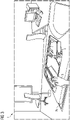
- Fig. 2 shows an alignment of a 3D model 2a on actual physical object in a physical environment 1.
- step S1 in Fig. 1 is necessary when the 3D model 2a needs to be aligned/overlaid in augmented reality onto an existing physical object 2b. Alignment is a common feature required when the overlaid 3D model along with its pre-imposed instructions or annotations are helping a service technician 3 to focus on any place of interest.
- the 3D model is arranged as an 3D outline.
- Places of Interests are explained as any area or part of the machine, object, etc. in context, where the user needs to focus on, to perform a particular task.
- Existing methods are using marker-based alignment methods with QR codes or other markers or manual alignment, which involves pinching or grabbing the 3D model and manipulating its scale, rotation, or position with hand gestures.
- the alignment is a common feature in most AR apps.
- Fig. 3 shows an optional feature of accessing the 3D model 2a (shown in Fig. 1 ) positioning and model transparency toggle via hand menu 4.
- the 3D model 2a needs to be transparent in order to blend the 3D model onto the actual physical object 2b and only see the identifiers (explained below with Fig. 4 ). Therefore, the quick access of the transparency toggling feature 4 is needed.
- Step S2 and S3 ( Fig. 1 ) of determining motion data by tracking at least one gesture of a user related to the physical object and of identifying said at least one place of interest by determining at least one intersection point of said at least one gesture and the physical object, wherein said at least one intersection point is determined by using at least one virtual proximity sensor comprised by the 3D model in relation to the motion data, is explained.
- Places of Interests are explained as any (typically small) area or part of the machine, object, etc. in context, where the user needs to focus on, to perform a particular task. These POIs could be specific parts of the physical object 2b or some special markings which need to be checked for correctness, for example.
- a 3D model 2b of the physical object 2b As claimed technical prerequisites are a 3D model 2b of the physical object 2b, a 3D engine supporting colliders (defined below), and an AR device capable of spatially mapping the environment (e.g. SLAM) and spatial hand tracking or gesture recognition for determining motion data by tracking at least one gesture of a user related to the physical object.
- SLAM spatial hand tracking or gesture recognition
- Colliders are defining the shape of a 3D object in the 3D scene and includes virtual sensors that detect proximity of intersection among 3D objects. This function is provided e.g. by a 3D engine like Unity3D.
- Fig. 4 shows identifiers (shown as arrows 5) positioned around the places of interest as selected by the user.
- the POIs in this example are holes on a car door frame.
- the display of virtual identifiers 5 can be automated to be moved exactly to these virtual touch points or to what is referred here as POIs.
- This automated movement can be done via a simple lerping algorithm (explained below).
- These POIs represent areas where any inspection or check needs to be performed.
- Different existing libraries can support with the spatial environmental information needed for the recognition and identification of the elements needed, such as spatial awareness (explained below) and hand tracking.
- Lerping is defined as the linear interpolation between two points. In this invention, this is used to move the identifiers from one point (random place in scene) to the other (to identified POIs). This function is provided e.g. by a 3D engine like Unity3D.
- a spatial awareness system provides real-world environmental awareness in mixed reality applications.
- a known technology is SLAM Simultaneous Localization and Mapping which creates a 3D map of the environment scanned with the AR device (e.g. via cameras or lidar).
- Spatial Awareness provides a collection of meshes, representing the geometry of the environment, which allowed for compelling interactions between holograms and the real-world.
- Advantages of the presented technologies include when there is a new AR app to be developed, the authoring of the 3D model 2a is often cumbersome. This usually involves a 2D or 3D desktop software, using which the author/user/developer marks the POIs which are then used later in the AR app. This process is slow and iterative and there is no instant AR validation of the same, since the desktop view will not justify the final AR outcome. Therefore, in this invention, a method to create POIs in the AR view directly using an AR device is proposed.
- a further technical problem that this invention aims to solve is the modification of the POI.
- the user can first enter the "edit POI mode". This can be done by the way of either pressing a button or any similar UI interaction. Once this edit mode is entered, the user can intuitively touch the identifier and change its transformational values by moving, resizing, or changing its orientation. The associated 3D coordinates will change when the user moves the identifier. Similarly, the rotational transforms also change when user orients the identifier to face up, down or sideways or at any angle that the user desires it to be. The POIs can also be manipulated to make it bigger or smaller and correspondingly the scale transforms on the POI will also be reflected. Different existing library are providing the basic movement, resizing and rotational changes to be able to be made to 3D info in the scene.
- the edit mode will also provide a delete functionality where in the user can delete (by way of a touchable button) identifiers which are not needed. All of this is done again within the AR app itself - there is no need for any coding or backend changes in any 2D software associated with the original source code of the templates.
- Fig. 5 shows the step of categorizing places of interest of a physical object 2b in the physical environment 1 into a predefined category 6 (step S11 in Fig. 1 ), especially of classifying identifiers.
- " R1", " R2", " R3" are examples of categories 6.
- the invention addresses the technical problem to fine tune the focus of the service technician, to further concentrate on specific identifiers. These could be particularly useful when there are different steps to the process of completing the task, and one want to only show the identifiers related to that step.
- the method of the invention offers both categorization without coding and direct validation in the AR app itself, which makes it quick and easy without iterations.
- the user interaction with an app according to the invention is also intuitive, which means no extensive learning modules of the software or coding required to categorize identifiers.
- overflow of information is avoided by using grouping of identifiers into categories 6. This also helps the user choose and focus on category 6 chosen to only show its identifiers to inspect.
- the technology for grouping of identifiers into categories 6 is also allowing for easy interaction and quick categorization.
- colliders are enabled for identifiers, spatial awareness is enabled, and an AR device.
- a user In a category editing mode, a user is allowed to enter the category name (otherwise a name like "category_1" is automatically suggested). This category name could be entered by using the virtual keyboard. Once the user has entered the name, he/she could proceed onto touching the identifiers and thereby selecting them to virtually group them in the category in context. If a mistake has been made, they can touch it again to unselect it from the category. This way of grouping the identifiers is quick and easy. It also avoids iterations when done traditionally from a 2D app vs direct validation in AR with 3D app. Moreover, overflow of information is avoided by using grouping of identifiers into categories. This also helps the user choose and focus on category chosen to only show its identifiers to inspect.
- the categorize mode can be imagined like a panel with different categories and the category needed can be selected by touch.
- the panel template to categorize is made available by an app template according to the invention.
- the app template shows the categories in the AR view by means of round buttons on a flat panel. These can be pressed to activate or deactivate the POIs in that category.
- Fig. 6 shows touching and selecting an identifier 5 of a place of interest of a physical object 2b in a physical environment 1 by hand 3. This is especially usefully for selecting an identifier 5 to perform an inspection or to add inspection information, to mark something as missing or faulty is a common use case in inspections or quality assurance.
- Prerequisites are that colliders for identifiers are enabled, spatial awareness is enabled, and an AR device.
- the identifier 5 in a purposed app template is an arrow.
- a user wishes to mark the arrow (or any identifier 5) by a way of saying that something is missing or faulty there, or is unexpected, they need to just touch the arrow. Touching it again toggles it back to the present or valid state. This can help if something has been marked wrong accidentally or the state needs to be simply toggled to a valid state after an inspection has been done.
- the touch technology is provided by the AR tool kit.
- the method for toggling between identifiers 5 and the concept is provided by an app template of the invention. This does not involve coding or any elaborate panels or annotation mechanisms.
- buttons are available as templates. These need to be just shown alongside a category option by reusing the template in the scene.
- Fig. 7 shows an example AR user manual 7 created according to the method step (S13, Fig. 1 ): Adding instructional data to said at least one place of interest.
- the AR user manual including instructional data 7 or work instructions.
- the AR app also needs to provide a virtual user manual 7 for the same purpose.
- an app template according to the invention provides an authoring tool in the AR view itself which is providing a very quick and easy UI to create user manuals 7 and provides instant validation in AR to the author or user 3.
- Prerequisites for this step are that objects are enabled with colliders for touch gesture to work, spatial awareness is enabled, and a head-mounted AR device.
- an app template Upon entry of these by the author 3, an app template according to the invention enables the panel in AR and shows how the AR manual 7 looks like. It would also automatically insert the next and back buttons and any logic needed therein (calculated from number of steps). This way any new manuals 7 or AR work instructions can be quickly created by using the 3D app template.
- the user can imagine entering a "manual editing mode", by way of touching a button and then choosing the step to be deleted by selection via touch. This does not involve coding if the template is used. However, the option to integrate and extend the customization is available via coding.
- the app template includes a video/photo taking feature which can be integrated into steps as needed.
- the objects are enabled with colliders for touch gesture to work, spatial awareness is enabled, and a head-mounted AR device.
- the photo taking logic involves in its AR view a photo frame 9, as shown in Fig. 8 , with four borders indicating the field of view 8 in order to guide the user to position the object/area being photographed within those borders
- a photo button which can be pressed to start the photo taking process.
- the photo button can either be pressed via touch gesture or controlled via eye gaze, especially a long gaze for more than 2 sec or controlled by a voice command to be activated.
- the invention introduces a delay of 1 sec after which the photo is clicked.
- the invention shows simultaneously a progress circle for 1 sec during which time the aforementioned delay is introduced. Once the photo is clicked, it is shown back to the user which acts as a validation method for the user to confirm or discard the photo taken. This step can also be made optional.
- Fig. 9 shows taking a picture of previously identified place of interest on a physical object as an example where a technician marks something on a physical object 2b within a physical environment 1 as missing or wrong, especially errors, faults, scratches, dents, and wants to take a picture to protocol it.
- a dedicated menu 10 is given for the process of marking something. A photo taken is displayed back onto a panel with the menu 10 for validation and correctness.
- a video taking logic (not shown) involves in its AR view:
- the app template provides these important features of photo and video recording which is needed in most inspection or training use cases. Any user needing to use these features can simply use the templates provided by the app to include these features. This does not involve coding if the template is used. However, the option to integrate and extend the customization is available via coding.
Landscapes
- Engineering & Computer Science (AREA)
- Theoretical Computer Science (AREA)
- Physics & Mathematics (AREA)
- General Physics & Mathematics (AREA)
- General Engineering & Computer Science (AREA)
- Multimedia (AREA)
- Human Computer Interaction (AREA)
- Software Systems (AREA)
- Business, Economics & Management (AREA)
- Computer Hardware Design (AREA)
- Computer Graphics (AREA)
- General Health & Medical Sciences (AREA)
- Human Resources & Organizations (AREA)
- Health & Medical Sciences (AREA)
- Ophthalmology & Optometry (AREA)
- Social Psychology (AREA)
- Economics (AREA)
- Entrepreneurship & Innovation (AREA)
- Marketing (AREA)
- Operations Research (AREA)
- Quality & Reliability (AREA)
- Strategic Management (AREA)
- Tourism & Hospitality (AREA)
- General Business, Economics & Management (AREA)
- Automation & Control Theory (AREA)
- Psychiatry (AREA)
- Computer Vision & Pattern Recognition (AREA)
- Processing Or Creating Images (AREA)
Priority Applications (5)
| Application Number | Priority Date | Filing Date | Title |
|---|---|---|---|
| EP21163948.9A EP4064006A1 (de) | 2021-03-22 | 2021-03-22 | Identifizierung eines ortes von interesse auf einem physikalischen objekt durch dessen 3d-modell in der ansicht mit erweiterter realität |
| US18/551,267 US20240168546A1 (en) | 2021-03-22 | 2022-03-01 | Identifying a Place of Interest on a Physical Object Through its 3D Model in Augmented Reality View |
| PCT/EP2022/055165 WO2022199995A1 (en) | 2021-03-22 | 2022-03-01 | Identifying a place of interest on a physical object through its 3d model in augmented reality view |
| EP22712900.4A EP4295217B1 (de) | 2021-03-22 | 2022-03-01 | Identifizierung eines ortes von interesse auf einem physikalischen objekt durch dessen 3d-modell in der ansicht mit erweiterter realität |
| CN202280037043.XA CN117377929A (zh) | 2021-03-22 | 2022-03-01 | 在增强现实视图中通过物理对象的3d模型来标识物理对象上的感兴趣地方 |
Applications Claiming Priority (1)
| Application Number | Priority Date | Filing Date | Title |
|---|---|---|---|
| EP21163948.9A EP4064006A1 (de) | 2021-03-22 | 2021-03-22 | Identifizierung eines ortes von interesse auf einem physikalischen objekt durch dessen 3d-modell in der ansicht mit erweiterter realität |
Publications (1)
| Publication Number | Publication Date |
|---|---|
| EP4064006A1 true EP4064006A1 (de) | 2022-09-28 |
Family
ID=75143511
Family Applications (2)
| Application Number | Title | Priority Date | Filing Date |
|---|---|---|---|
| EP21163948.9A Withdrawn EP4064006A1 (de) | 2021-03-22 | 2021-03-22 | Identifizierung eines ortes von interesse auf einem physikalischen objekt durch dessen 3d-modell in der ansicht mit erweiterter realität |
| EP22712900.4A Active EP4295217B1 (de) | 2021-03-22 | 2022-03-01 | Identifizierung eines ortes von interesse auf einem physikalischen objekt durch dessen 3d-modell in der ansicht mit erweiterter realität |
Family Applications After (1)
| Application Number | Title | Priority Date | Filing Date |
|---|---|---|---|
| EP22712900.4A Active EP4295217B1 (de) | 2021-03-22 | 2022-03-01 | Identifizierung eines ortes von interesse auf einem physikalischen objekt durch dessen 3d-modell in der ansicht mit erweiterter realität |
Country Status (4)
| Country | Link |
|---|---|
| US (1) | US20240168546A1 (de) |
| EP (2) | EP4064006A1 (de) |
| CN (1) | CN117377929A (de) |
| WO (1) | WO2022199995A1 (de) |
Cited By (2)
| Publication number | Priority date | Publication date | Assignee | Title |
|---|---|---|---|---|
| CN116452186A (zh) * | 2023-03-30 | 2023-07-18 | 中泰信达环保科技(武汉)有限公司 | 应用于污水处理厂的巡检管理系统及方法 |
| WO2025036553A1 (de) * | 2023-08-14 | 2025-02-20 | Siemens Aktiengesellschaft | Farbliche kennzeichnung relevanter bereiche in einer erweiterten oder virtuellen realität |
Families Citing this family (1)
| Publication number | Priority date | Publication date | Assignee | Title |
|---|---|---|---|---|
| US20250111527A1 (en) * | 2023-10-03 | 2025-04-03 | The Boeing Company | Systems, methods, and apparatus for locating faults or conditions of systems |
Citations (4)
| Publication number | Priority date | Publication date | Assignee | Title |
|---|---|---|---|---|
| CN108509026A (zh) * | 2018-02-06 | 2018-09-07 | 西安电子科技大学 | 基于增强交互方式的远程维修支持系统及方法 |
| US20190279424A1 (en) * | 2018-03-07 | 2019-09-12 | California Institute Of Technology | Collaborative augmented reality system |
| DK201800123A1 (en) * | 2018-03-18 | 2019-10-01 | Maersk Drilling A/S | Augmented Reality Maintenance System |
| US20210074071A1 (en) * | 2019-09-05 | 2021-03-11 | Bayerische Motoren Werke Aktiengesellschaft | System and Method for the Robust Implementation of AR Applications on Vehicles |
Family Cites Families (13)
| Publication number | Priority date | Publication date | Assignee | Title |
|---|---|---|---|---|
| US9015245B1 (en) * | 2011-07-20 | 2015-04-21 | Google Inc. | Experience sharing with commenting |
| US9881419B1 (en) * | 2012-02-02 | 2018-01-30 | Bentley Systems, Incorporated | Technique for providing an initial pose for a 3-D model |
| WO2016164342A1 (en) * | 2015-04-06 | 2016-10-13 | Scope Technologies Us Inc. | Methods and apparatus for augmented reality applications |
| US10339382B2 (en) * | 2015-05-31 | 2019-07-02 | Fieldbit Ltd. | Feedback based remote maintenance operations |
| US20160358383A1 (en) * | 2015-06-05 | 2016-12-08 | Steffen Gauglitz | Systems and methods for augmented reality-based remote collaboration |
| US10366521B1 (en) * | 2017-03-15 | 2019-07-30 | Amazon Technologies, Inc. | Augmented reality assembly assistance and monitoring |
| US10395427B1 (en) * | 2017-04-11 | 2019-08-27 | Bentley Systems, Incorporated | On-site visualization and modeling using P and ID drawings and augmented reality |
| US20180357826A1 (en) * | 2017-06-10 | 2018-12-13 | Tsunami VR, Inc. | Systems and methods for using hierarchical relationships of different virtual content to determine sets of virtual content to generate and display |
| US11275481B2 (en) * | 2018-03-07 | 2022-03-15 | California Institute Of Technology | Collaborative augmented reality system |
| US11227439B2 (en) * | 2018-03-29 | 2022-01-18 | Eon Reality, Inc. | Systems and methods for multi-user virtual reality remote training |
| CN115016638B (zh) * | 2018-10-15 | 2025-11-18 | 美的集团股份有限公司 | 提供虚拟指导的方法、计算机系统及计算机可读存储介质 |
| US10970547B2 (en) * | 2018-12-07 | 2021-04-06 | Microsoft Technology Licensing, Llc | Intelligent agents for managing data associated with three-dimensional objects |
| US10846899B2 (en) * | 2019-04-17 | 2020-11-24 | Honeywell International Inc. | Methods and systems for augmented reality safe visualization during performance of tasks |
-
2021
- 2021-03-22 EP EP21163948.9A patent/EP4064006A1/de not_active Withdrawn
-
2022
- 2022-03-01 EP EP22712900.4A patent/EP4295217B1/de active Active
- 2022-03-01 CN CN202280037043.XA patent/CN117377929A/zh active Pending
- 2022-03-01 WO PCT/EP2022/055165 patent/WO2022199995A1/en not_active Ceased
- 2022-03-01 US US18/551,267 patent/US20240168546A1/en active Pending
Patent Citations (4)
| Publication number | Priority date | Publication date | Assignee | Title |
|---|---|---|---|---|
| CN108509026A (zh) * | 2018-02-06 | 2018-09-07 | 西安电子科技大学 | 基于增强交互方式的远程维修支持系统及方法 |
| US20190279424A1 (en) * | 2018-03-07 | 2019-09-12 | California Institute Of Technology | Collaborative augmented reality system |
| DK201800123A1 (en) * | 2018-03-18 | 2019-10-01 | Maersk Drilling A/S | Augmented Reality Maintenance System |
| US20210074071A1 (en) * | 2019-09-05 | 2021-03-11 | Bayerische Motoren Werke Aktiengesellschaft | System and Method for the Robust Implementation of AR Applications on Vehicles |
Cited By (3)
| Publication number | Priority date | Publication date | Assignee | Title |
|---|---|---|---|---|
| CN116452186A (zh) * | 2023-03-30 | 2023-07-18 | 中泰信达环保科技(武汉)有限公司 | 应用于污水处理厂的巡检管理系统及方法 |
| CN116452186B (zh) * | 2023-03-30 | 2024-03-01 | 中泰信达环保科技(武汉)有限公司 | 应用于污水处理厂的巡检管理系统及方法 |
| WO2025036553A1 (de) * | 2023-08-14 | 2025-02-20 | Siemens Aktiengesellschaft | Farbliche kennzeichnung relevanter bereiche in einer erweiterten oder virtuellen realität |
Also Published As
| Publication number | Publication date |
|---|---|
| US20240168546A1 (en) | 2024-05-23 |
| EP4295217B1 (de) | 2025-06-04 |
| EP4295217A1 (de) | 2023-12-27 |
| EP4295217C0 (de) | 2025-06-04 |
| WO2022199995A1 (en) | 2022-09-29 |
| CN117377929A (zh) | 2024-01-09 |
Similar Documents
| Publication | Publication Date | Title |
|---|---|---|
| EP4295217B1 (de) | Identifizierung eines ortes von interesse auf einem physikalischen objekt durch dessen 3d-modell in der ansicht mit erweiterter realität | |
| Cheng et al. | State-of-the-art review on mixed reality applications in the AECO industry | |
| JP7393833B2 (ja) | ユーザ入力に基づいて生成された人工知能モデルを使用し、仮想欠陥画像を生成するためのコンピュータプログラム、方法、及び装置 | |
| García-Pereira et al. | A collaborative augmented reality annotation tool for the inspection of prefabricated buildings | |
| US9098313B2 (en) | Recording display-independent computerized guidance | |
| TWI842931B (zh) | 自動判別處理裝置、自動判別處理方法、檢查系統、程式、及記錄媒體 | |
| US20120042281A1 (en) | Same-display comparison of content for different renditions of a single computer program | |
| KR101076867B1 (ko) | 콘텐츠를 생성하기 위한 자동 이미지 캡처 | |
| WO2012142250A1 (en) | Augumented reality system | |
| KR20060129177A (ko) | 스케칭을 통한 사용자 인터페이스 설명의 자동 생성 | |
| US12038832B2 (en) | Electronic product testing systems for providing automated product testing with human-in-the loop component and/or object detection | |
| CN115273569B (zh) | 一种智能光影引导系统 | |
| US20200097725A1 (en) | Automatic generation of user interfaces using image recognition | |
| Foroughi Sabzevar et al. | Improving access to design information of paper-based floor plans using augmented reality | |
| JP2011081778A (ja) | ディスプレイ非依存のコンピュータによるガイダンス方法および装置 | |
| CN120086125A (zh) | 一种基于多智能体的场景粒度界面测试用例生成方法 | |
| TWI798514B (zh) | 人工智慧輔助擴增實境系統與方法、電腦程式產品 | |
| WO2007118271A1 (en) | A method and system and product for conditioning software | |
| CN117396760A (zh) | 用于执行化学工作流程的方法 | |
| KR100886657B1 (ko) | 선체 블록용 치수품질 검사기준 문서 작성 시스템 및 방법 | |
| Lauritsen et al. | AR-based UI for improving IO setup in robot deployment process | |
| JP2008140036A (ja) | 作業支援装置および方法 | |
| CN119766986A (zh) | 一种测试方法、系统、设备、程序产品及存储介质 | |
| Daroczi et al. | Automated Testing of Interaction-Requiring Devices with a Robotic Arm and Object Detection | |
| Learning et al. | Evaluating an Augmented Reality Prototype for Enhanced User Guidance in |
Legal Events
| Date | Code | Title | Description |
|---|---|---|---|
| PUAI | Public reference made under article 153(3) epc to a published international application that has entered the european phase |
Free format text: ORIGINAL CODE: 0009012 |
|
| STAA | Information on the status of an ep patent application or granted ep patent |
Free format text: STATUS: THE APPLICATION HAS BEEN PUBLISHED |
|
| AK | Designated contracting states |
Kind code of ref document: A1 Designated state(s): AL AT BE BG CH CY CZ DE DK EE ES FI FR GB GR HR HU IE IS IT LI LT LU LV MC MK MT NL NO PL PT RO RS SE SI SK SM TR |
|
| STAA | Information on the status of an ep patent application or granted ep patent |
Free format text: STATUS: THE APPLICATION IS DEEMED TO BE WITHDRAWN |
|
| 18D | Application deemed to be withdrawn |
Effective date: 20230329 |