EP3968286A2 - Verfahren, vorrichtung, elektronisches gerät und speichermedium zur erkennung von gebäudeveränderungen - Google Patents
Verfahren, vorrichtung, elektronisches gerät und speichermedium zur erkennung von gebäudeveränderungen Download PDFInfo
- Publication number
- EP3968286A2 EP3968286A2 EP22152169.3A EP22152169A EP3968286A2 EP 3968286 A2 EP3968286 A2 EP 3968286A2 EP 22152169 A EP22152169 A EP 22152169A EP 3968286 A2 EP3968286 A2 EP 3968286A2
- Authority
- EP
- European Patent Office
- Prior art keywords
- building
- remote
- sensing image
- probability
- pixel
- Prior art date
- Legal status (The legal status is an assumption and is not a legal conclusion. Google has not performed a legal analysis and makes no representation as to the accuracy of the status listed.)
- Withdrawn
Links
Images




Classifications
-
- G—PHYSICS
- G06—COMPUTING OR CALCULATING; COUNTING
- G06V—IMAGE OR VIDEO RECOGNITION OR UNDERSTANDING
- G06V20/00—Scenes; Scene-specific elements
- G06V20/10—Terrestrial scenes
- G06V20/176—Urban or other man-made structures
-
- G—PHYSICS
- G06—COMPUTING OR CALCULATING; COUNTING
- G06T—IMAGE DATA PROCESSING OR GENERATION, IN GENERAL
- G06T7/00—Image analysis
- G06T7/10—Segmentation; Edge detection
- G06T7/11—Region-based segmentation
-
- G—PHYSICS
- G06—COMPUTING OR CALCULATING; COUNTING
- G06F—ELECTRIC DIGITAL DATA PROCESSING
- G06F18/00—Pattern recognition
- G06F18/20—Analysing
- G06F18/21—Design or setup of recognition systems or techniques; Extraction of features in feature space; Blind source separation
- G06F18/214—Generating training patterns; Bootstrap methods, e.g. bagging or boosting
-
- G—PHYSICS
- G06—COMPUTING OR CALCULATING; COUNTING
- G06N—COMPUTING ARRANGEMENTS BASED ON SPECIFIC COMPUTATIONAL MODELS
- G06N3/00—Computing arrangements based on biological models
- G06N3/02—Neural networks
- G06N3/04—Architecture, e.g. interconnection topology
- G06N3/0464—Convolutional networks [CNN, ConvNet]
-
- G—PHYSICS
- G06—COMPUTING OR CALCULATING; COUNTING
- G06N—COMPUTING ARRANGEMENTS BASED ON SPECIFIC COMPUTATIONAL MODELS
- G06N3/00—Computing arrangements based on biological models
- G06N3/02—Neural networks
- G06N3/08—Learning methods
- G06N3/09—Supervised learning
-
- G—PHYSICS
- G06—COMPUTING OR CALCULATING; COUNTING
- G06T—IMAGE DATA PROCESSING OR GENERATION, IN GENERAL
- G06T3/00—Geometric image transformations in the plane of the image
- G06T3/40—Scaling of whole images or parts thereof, e.g. expanding or contracting
- G06T3/4038—Image mosaicing, e.g. composing plane images from plane sub-images
-
- G—PHYSICS
- G06—COMPUTING OR CALCULATING; COUNTING
- G06T—IMAGE DATA PROCESSING OR GENERATION, IN GENERAL
- G06T7/00—Image analysis
- G06T7/10—Segmentation; Edge detection
- G06T7/162—Segmentation; Edge detection involving graph-based methods
-
- G—PHYSICS
- G06—COMPUTING OR CALCULATING; COUNTING
- G06V—IMAGE OR VIDEO RECOGNITION OR UNDERSTANDING
- G06V10/00—Arrangements for image or video recognition or understanding
- G06V10/20—Image preprocessing
- G06V10/26—Segmentation of patterns in the image field; Cutting or merging of image elements to establish the pattern region, e.g. clustering-based techniques; Detection of occlusion
- G06V10/267—Segmentation of patterns in the image field; Cutting or merging of image elements to establish the pattern region, e.g. clustering-based techniques; Detection of occlusion by performing operations on regions, e.g. growing, shrinking or watersheds
-
- G—PHYSICS
- G06—COMPUTING OR CALCULATING; COUNTING
- G06V—IMAGE OR VIDEO RECOGNITION OR UNDERSTANDING
- G06V20/00—Scenes; Scene-specific elements
- G06V20/70—Labelling scene content, e.g. deriving syntactic or semantic representations
-
- G—PHYSICS
- G06—COMPUTING OR CALCULATING; COUNTING
- G06N—COMPUTING ARRANGEMENTS BASED ON SPECIFIC COMPUTATIONAL MODELS
- G06N3/00—Computing arrangements based on biological models
- G06N3/02—Neural networks
- G06N3/08—Learning methods
-
- G—PHYSICS
- G06—COMPUTING OR CALCULATING; COUNTING
- G06T—IMAGE DATA PROCESSING OR GENERATION, IN GENERAL
- G06T2200/00—Indexing scheme for image data processing or generation, in general
- G06T2200/32—Indexing scheme for image data processing or generation, in general involving image mosaicing
-
- Y—GENERAL TAGGING OF NEW TECHNOLOGICAL DEVELOPMENTS; GENERAL TAGGING OF CROSS-SECTIONAL TECHNOLOGIES SPANNING OVER SEVERAL SECTIONS OF THE IPC; TECHNICAL SUBJECTS COVERED BY FORMER USPC CROSS-REFERENCE ART COLLECTIONS [XRACs] AND DIGESTS
- Y02—TECHNOLOGIES OR APPLICATIONS FOR MITIGATION OR ADAPTATION AGAINST CLIMATE CHANGE
- Y02A—TECHNOLOGIES FOR ADAPTATION TO CLIMATE CHANGE
- Y02A30/00—Adapting or protecting infrastructure or their operation
- Y02A30/60—Planning or developing urban green infrastructure
Definitions
- the disclosure relates to the field of computer technologies, and particularly to the field of artificial intelligence (AI) such as deep learning and computer vision, and especially to a method for detecting a change of a building, an apparatus for detecting a change of a building, an electronic device and a storage medium.
- AI artificial intelligence
- the detection on the change of the building is widely used in various applications such as urban development research, post-disaster reconstruction, discovery of building violations and land use dynamic analysis.
- the method for detecting the change of the building in the related art is to perform the building detection on a single remote-sensing image corresponding to each time point to obtain a detection result, and compare a detection result of a remote-sensing image corresponding to a current time point with a detection result of a remote-sensing image corresponding to a previous time point to determine whether the building has changed.
- the number of pixels occupied by the building in the remote-sensing image is generally small, for example, it may be 1 pixel. Therefore, it is prone to a detection error when the building detection is performed based on the single remote-sensing image, for example, a tree is determined as the building. Furthermore, it leads to the low accuracy of the detection result of the change of the building.
- the disclosure provides a method for detecting a change of a building, an apparatus for detecting a change of a building, an electronic device, a storage medium and a computer program product.
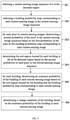
- a method for detecting a change of a building including: obtaining a remote-sensing image sequence of a to-be-detected region; obtaining a building probability map corresponding to each remote-sensing image in the remote-sensing image sequence; determining a sub-region located by each building in the to-be-detected region based on the building probability map corresponding to each remote-sensing image; for each building, determining an existence probability of the building in each remote-sensing image based on the sub-region located by the building and the building probability map corresponding to each remote-sensing image; and determining a change condition of the building based on the existence probability of the building in each remote-sensing image.
- an apparatus for detecting a change of a building including: a first obtaining module, configured to obtain a remote-sensing image sequence of a to-be-detected region; a second obtaining module, configured to obtain a building probability map corresponding to each remote-sensing image in the remote-sensing image sequence; a first determining module, configured to determine a sub-region located by each building in the to-be-detected region based on the building probability map corresponding to each remote-sensing image; a second determining module, configured to determine, for each building, an existence probability of the building in each remote-sensing image based on the sub-region located by the building and the building probability map corresponding to each remote-sensing image; and a third determining module, configured to determine a change condition of the building based on the existence probability of the building in each remote-sensing image.
- an electronic device including: at least one processor; and a memory communicatively coupled to the at least one processor.
- the memory is configured to store instructions executable by the at least one processor. When the instructions are executed by the at least one processor, the at least one processor is caused to perform the method as described above.
- a non-transitory computer-readable storage medium storing computer instructions thereon.
- the computer instructions are configured to cause a computer to perform the method as described above.
- a computer program product including a computer program.
- the computer program When the computer program is executed by a processor, the method as described above.
- the method for detecting the change of the building in the related art is to perform the building detection on a single remote-sensing image corresponding to each time point to obtain a detection result, and compare a detection result of a remote-sensing image corresponding to a current time point with a detection result of a remote-sensing image corresponding to a previous time point to determine whether the building has changed.
- the number of pixels occupied by the building in the remote-sensing image is generally small, for example, it may be 1 pixel. Therefore, it is prone to a detection error when the building detection is performed based on the single remote-sensing image, for example, a tree is determined as the building. Furthermore, it leads to the low accuracy of the detection result of the change of the building.
- the disclosure proposes the method for detecting the change of the building.
- the method obtains a remote-sensing image sequence of a to-be-detected region, obtains a building probability map corresponding to each remote-sensing image in the remote-sensing image sequence, determines a sub-region located by each building in the to-be-detected region based on the building probability map corresponding to each remote-sensing image, determines, for each building, an existence probability of the building in each remote-sensing image based on the sub-region located by the building and the building probability map corresponding to each remote-sensing image; and determines a change condition of the building based on the existence probability of the building in each remote-sensing image.
- the change condition of the building is determined by combining the building probability map of each remote-sensing image in the remote-sensing image sequence of the to-be-detected region. Therefore, the accuracy of the result of detecting the change of the building is improved.
- a method for detecting a change of a building an apparatus for detecting a change of a building, an electronic device, a non-transitory computer-readable storage medium and a computer program product of embodiments of the disclosure are described below with reference to the drawings.
- FIG. 1 is a flowchart illustrating a method for detecting a change of a building, according to a first embodiment of the disclosure.
- the execution subject of the method for detecting the change of the building provided in some embodiments of the disclosure is an apparatus for detecting a change of a building.
- the apparatus for detecting the change of the building may be an electronic device or be configured in the electronic device to improve the accuracy of the result of detecting the change of the building.
- the electronic device may be any static or mobile computing device capable of data processing.
- the electronic device may be the mobile computing device, such as a laptop, a smart phone or a wearable device.
- the electronic device may also be the static computing device such as a desktop computer.
- the electronic device may also be a server or other type of computing device. The disclosure does not limit the electronic device.
- the method may include the following.
- the to-be-detected region is a region to be detected for building change conditions, for example, a city, a village, a region surrounded by a range of longitude and latitude.
- the remote-sensing image sequence includes multiple remote-sensing images arranged in order of time points. Each remote-sensing image corresponds to a time point.
- a building probability map corresponding to each remote-sensing image in the remote-sensing image sequence is obtained.
- the building probability map corresponding to each remote-sensing image includes a first probability that each pixel in the corresponding remote-sensing image belongs to a building.
- the building probability map corresponding to the remote-sensing image may be obtained.
- a sub-region located by each building in the to-be-detected region is determined based on the building probability map corresponding to each remote-sensing image.
- the sub-region located by the building in each remote-sensing image in the remote-sensing image sequence is the same.
- the sub-region located by the building in the remote-sensing image may include each pixel corresponding to the building in the remote-sensing image.
- the sub-region located by the building in each remote-sensing image in the remote-sensing image sequence includes a pixel in the first row and the second column, a pixel in the first row and the third column, a pixel in the second row and the second column and a pixel in the second row and the third column.
- each building it is not necessary to perform multiple calculations based on the building probability map corresponding to each remote-sensing image. Through one calculation, the sub-region located by the building in each remote-sensing image in the remote-sensing image sequence may be obtained.
- the sub-region located by each building in the to-be-detected region when determining the sub-region located by each building in the to-be-detected region based on the building probability map corresponding to each remote-sensing image, the sub-region located by each building in the to-be-detected region may be determined based on the first probability that each pixel in the building probability map corresponding to each remote-sensing image belongs to the building and a watershed algorithm.
- each remote-sensing image in the remote-sensing image sequence is the same, and each pixel in different remote-sensing images corresponds to each other one to one.
- an existence probability of the building in each remote-sensing image is determined based on the sub-region located by the building and the building probability map corresponding to each remote-sensing image.
- the existence probability of the building in the corresponding remote-sensing image may be determined based on the sub-region located by the building and the building probability map corresponding to each remote-sensing image.
- the first probability of each pixel in the sub-region located by the building belongs to the building may be obtained based on the building probability map corresponding to the remote-sensing image, and the existence probability of the building in the remote-sensing image may be determined based on the first probabilities that all pixels in the sub-region located by the building belong to the building.
- the existence probability of the building in each remote-sensing image may be determined in a variety of ways. For example, after the first probability that each pixel in the sub-region located by the building belongs to the building is obtained based on the building probability map corresponding to the remote-sensing image, the largest first probability among the first probabilities may be used as the existence probability of the building in the remote-sensing image or the average value of the first probabilities may be used as the existence probability of the building in the remote-sensing image, which is not limited herein.
- a change condition of the building is determined based on the existence probability of the building in each remote-sensing image.
- each remote-sensing image it is possible to determine whether the building exists in the remote-sensing image based on the existence probability of the building in the remote-sensing image, and the change condition of the building is determined based on the existence condition of the building in the remote-sensing image.
- the apparatus for detecting the change of the building may determine that the building A is newly built at the time point corresponding to the second remote-sensing image. It is assumed that it is determined that the building B exists in the first remote-sensing image but does not exist in the second remote-sensing image, the apparatus for detecting the change of the building may determine that at the time point corresponding to the second remote-sensing image, the building B is demolished or damaged.
- the sub-region located by each building in the to-be-detected region is determined based on the building probability map corresponding to each remote-sensing image in the remote-sensing image sequence. It is possible to accurately determine the sub-region located by each building in the to-be-detected region. Furthermore, it is possible to accurately determine the existence probability of each building in each remote-sensing image. Therefore, the accuracy of the result of detecting the change of the building is improved.
- the method for detecting the change of the building obtains the remote-sensing image sequence of the to-be-detected region, obtains the building probability map corresponding to each remote-sensing image in the remote-sensing image sequence, determines the sub-region located by each building in the to-be-detected region based on the building probability map corresponding to each remote-sensing image, determines, for each building, the existence probability of the building in each remote-sensing image based on the sub-region located by the building and the building probability map corresponding to each remote-sensing image; and determines the change condition of the building based on the existence probability of the building in each remote-sensing image.
- the change condition of the building is determined by combining the building probability map of each remote-sensing image in the remote-sensing image sequence of the to-be-detected region. Therefore, the accuracy of the result of detecting the change of the building is improved.
- the building probability map corresponding to each remote-sensing image in the remote-sensing image sequence may be obtained.
- the process of determining the building probability map corresponding to each remote-sensing image in the remote-sensing image sequence may be further explained in the following with reference to FIG. 2 .
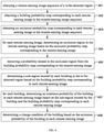
- FIG. 2 is a flowchart illustrating a method for detecting a change of a building, according to a second embodiment of the disclosure. As shown in FIG. 2 , the method includes the following.
- a remote-sensing image sequence of a to-be-detected region is obtained.
- image blocks are obtained by segmenting the remote-sensing image.
- building probability maps corresponding to the image blocks are obtained by inputting each image block into a semantic segmentation model.
- the building probability map corresponding to the remote-sensing image is generated by splicing the building probability maps corresponding to the image blocks.
- the semantic segmentation model may be pre-trained.
- the input of the semantic segmentation model is the remote-sensing image and the output is the building probability map with the same size as the remote-sensing image.
- each remote-sensing image is processed to obtain the building probability map corresponding to the corresponding remote-sensing image.
- the semantic segmentation model may be any type of model that may realize semantic segmentation of images in the computer vision field, such as a neural network model, which is not limited in the disclosure.
- the size of the remote-sensing image is usually large and the semantic segmentation model may not be able to process the large-sized remote-sensing image.
- the remote-sensing image may be segmented first to obtain multiple image blocks, and the multiple image blocks are input into the semantic segmentation model respectively to obtain the building probability maps corresponding to the multiple image blocks, and the building probability maps corresponding to the multiple image blocks may be spliced to generate the building probability map corresponding to the remote-sensing image.
- each remote-sensing image may be segmented into corresponding fixed-size image blocks according to the size of the remote-sensing image that may be processed by the semantic segmentation model.
- the semantic segmentation model obtained by pre-training is used to accurately obtain the building probability map corresponding to the remote-sensing image.
- the following manners may be used to train the semantic segmentation model.
- An initial semantic segmentation model is obtained.
- Training data are obtained.
- the training data include sample image blocks and label data corresponding to each sample image block.
- the label data include at least one of: city planning information, map building information and third national land survey data.
- the semantic segmentation model is obtained by training the initial semantic segmentation model based on the sample image blocks and the label data corresponding to each sample image block.
- the initial semantic segmentation model may be any type of model in the computer vision field that may realize the semantic segmentation of images, such as a neural network model, which is not limited in the disclosure.
- the input of the semantic segmentation model is the image block after segmentation of the remote-sensing image, rather than the remote-sensing image sequence, so that there is no need to obtain the remote-sensing image sequence labeled with the region of the building as the training samples.
- the remote-sensing image of any resolution at a single time point taken by any remote-sensing satellite in any region may be conveniently used as training data to train and generate the semantic segmentation model in conjunction with the manual label data of remote-sensing images.
- the remote-sensing image at the corresponding time point may be selected directly from a large number of remote-sensing images obtained by remote-sensing satellites based on at least one of: city planning information, map building information and third national land survey data.
- the selected remote-sensing image is segmented into fixed-size image blocks as sample image blocks.
- the label data of each sample image block may be determined based on at least one of: city planning information, map building information and third national land survey data at the corresponding time point. Therefore, the training data are obtained.
- the label data corresponding to each sample image block corresponds to the time point of the sample image block.
- the remote-sensing image having the time difference with at least one of city planning information, map building information and third national land survey data within a preset time range may be used as the remote-sensing image corresponding to the time point of at least one of city planning information, map building information and third national land survey data.
- the city planning information is used as the label data corresponding to the sample image block
- the preset time range is 7 days
- the time point of the city planning information is January 15.
- the remote-sensing image at the time point with the smallest time difference from January 15 is selected as the remote-sensing image corresponding to the time point of the city planning information.
- the selected remote-sensing image may be segmented into multiple image blocks of fixed size as the sample image blocks, and the city planning information at the time point of January 15 may be used as the label data corresponding to the multiple sample image blocks to obtain training data.
- sample image blocks and the corresponding label data of each sample image block may be used to train the initial semantic segmentation model, for example, it may be trained through deep learning. Compared with other machine learning methods, deep learning performs better on large data sets.
- one sample image block of multiple sample image blocks may be used as the input to input the initial semantic segmentation model, and the building probability map corresponding to the sample image block is obtained.
- the parameters of the initial semantic segmentation model may be adjusted by combining the sample image block and the label data corresponding to the sample image block to obtain the adjusted semantic segmentation model.
- another sample image block of the multiple sample image blocks may be used as the input to input the adjusted semantic segmentation model, and the building probability map corresponding to the sample image block is obtained.
- the parameters of the adjusted semantic segmentation model may be adjusted by combining the sample image block and the label data corresponding to the sample image block to obtain the further adjusted semantic segmentation model.
- the initial semantic segmentation model is iteratively trained by continuously adjusting the model parameters of the initial semantic segmentation model until the accuracy of the building probability map output by the semantic segmentation model satisfies the preset threshold.
- the training ends, and the trained semantic segmentation model is obtained.
- any remote-sensing image of any resolution at a single time point taken by any remote-sensing satellite in any region by matching at least one of city planning information, map building information and third national land survey data as the label data may be used to obtain the accurate training data.
- the semantic segmentation model is generated by training, thereby saving the labor cost required to obtain label data and improving the iterative speed of the semantic segmentation model. Also, the initial semantic segmentation model is trained through this training data, which improves the generalization ability of the trained semantic segmentation model.
- a sub-region located by each building in the to-be-detected region is determined based on the building probability map corresponding to each remote-sensing image.
- an existence probability of the building in each remote-sensing image is determined based on the sub-region located by the building and the building probability map corresponding to each remote-sensing image.
- a change condition of the building is determined based on the existence probability of the building in each remote-sensing image.
- the method for detecting the change of the building obtains the remote-sensing image sequence of the to-be-detected region; obtains, for each remote-sensing image in the remote-sensing image sequence, the image blocks by segmenting the remote-sensing image; obtains the building probability maps corresponding to the image blocks by inputting each image block into the semantic segmentation model; generates the building probability map corresponding to the remote-sensing image by splicing the building probability maps corresponding to the image blocks; determines the sub-region located by each building in the to-be-detected region based on the building probability map corresponding to each remote-sensing image; determines, for each building, the existence probability of the building in each remote-sensing image based on the sub-region located by the building and the building probability map corresponding to each remote-sensing image; and determines the change condition of the building based on the existence probability of the building in each remote-sensing image.
- the semantic segmentation model is used to obtain the building probability map corresponding to each remote-sensing image in the remote-sensing image sequence, and the change condition of the building is determined by combining the building probability map of each remote-sensing image in the remote-sensing image sequence of the to-be-detected region. Therefore, the accuracy of the result of detecting the change of the building is improved.
- FIG. 3 is a flowchart illustrating a method for detecting a change of a building, according to a third embodiment of the disclosure. As shown in FIG. 3 , the method includes the following.
- a remote-sensing image sequence of a to-be-detected region is obtained.
- a building probability map corresponding to each remote-sensing image in the remote-sensing image sequence is obtained.
- the building probability map corresponding to each remote-sensing image includes a first probability that each pixel in the corresponding remote-sensing image belongs to a building.
- a second probability of the pixel in the remote-sensing image sequence is determined based on the first probability of the pixel in the building probability map corresponding to each remote-sensing image.
- the second probability of the pixel in the remote-sensing image sequence may be obtained by: obtaining first remote-sensing images from the remote-sensing image sequence, in which the first remote-sensing image is a remote-sensing image with the first probability of the pixel greater than a first probability threshold; and obtaining the second probability of the pixel in the remote-sensing image sequence by performing a weighted average on the first probability of the pixel in each first remote-sensing image.
- the first probability threshold may be set arbitrarily as needed, for example, it may be set to 0.1.
- the second probability of the pixel in the remote-sensing image sequence may be obtained by the following formula (1).
- S ij ⁇ t P ij t I P ij t ⁇ ⁇ max ⁇ t I P ij t ⁇ ⁇ , ⁇
- S ij is the second probability of the pixel in the i th row and the j th column in the remote-sensing image sequence
- ⁇ is the first probability threshold
- P ij t is the first probability that the pixel in the i th row and the j th column in the t th remote-sensing image belongs to the building
- ⁇ t P ij t I P ij t ⁇ ⁇ is the sum of the first probabilities of the pixel in the i th row and the j th column in the first remote-sensing images
- ⁇ t I P ij t ⁇ ⁇ is the number of the first remote-sens
- the first probability of that pixel in the building probability map corresponding to each remote-sensing image may be compared with the first probability threshold, and the remote-sensing image with the first probability greater than the first probability threshold is determined as the first remote-sensing image.
- the first probability of the pixel in the first row and the first column in each first remote-sensing image is weighted and averaged to obtain the second probability of the pixel in the first row and the first column of the remote-sensing image sequence.
- the second probability of each pixel in the remote-sensing image sequence may be obtained.
- the first probability that each pixel in the building probability map corresponding to each remote-sensing image belongs to the building may have an error, which is usually not 0 or 1. Then, in some embodiments of the disclosure, by pre-setting the first probability threshold, the first probability of the pixel in the building probability map corresponding to each remote-sensing image may be filtered based on the first probability threshold. Therefore, for each pixel in the remote-sensing images, the second probability of the pixel in the remote-sensing image sequence is obtained based only on the larger first probability that the pixel in each remote-sensing image belongs to the building, thereby improving the accuracy of obtaining the second probability of the pixel in the remote-sensing image sequence.
- the sub-region located by each building in the to-be-detected region is determined based on the second probability of each pixel in the remote-sensing image sequence.
- the sub-region located by each building in the to-be-detected region is determined by: obtaining a first pixel with a maximum second probability as a center pixel of each building based on the second probability of each pixel in the remote-sensing image sequence; determining pixel boundaries of each building by combining the first pixel and a watershed algorithm; and determining the sub-region located by each building in the to-be-detected region based on the pixel boundaries and the center pixel.
- the pixel with the local maximum second probability in the remote-sensing image sequence may be considered as the center pixel of each building. Then, in some embodiments of the disclosure, it may obtain the first pixel with the corresponding maximum second probability as the center pixel of each building based on the second probability of each pixel in the remote-sensing image sequence.
- a third probability threshold may also be set in advance.
- the third probability threshold may be set arbitrarily based on needs, for example, set to 0.4.
- the first pixel with the second probability greater than the third probability threshold and having the maximum value may be obtained based on the second probability of each pixel in the remote-sensing image sequence, and used as the center pixel of each building.
- Pixel boundaries of each building are determined by combining the first pixel and a watershed algorithm after the center pixel of each building.
- an all-zero matrix with the same number of rows and columns as the number of rows and columns of the pixels in the remote-sensing image sequence may be set based on the number of rows and columns of the pixels in the remote-sensing image sequence.
- the element corresponding to the same row and the same column as the first pixel in the all-zero matrix is set to 1, to obtain another matrix, which is assumed to be Mi.
- the remote-sensing image sequence includes 6 rows and 6 columns of pixels, and the first pixels are the pixel in the second row and the third column and the pixel in the fourth row and the fifth column of the remote-sensing image sequence.
- a matrix of all 0s with 6 rows and 6 columns may be set.
- the elements in the second row and the third column and in the fourth row and the fifth column may be set to 1 to obtain the matrix Mi.
- a fourth probability threshold may be set in advance, where the fourth probability threshold may be arbitrarily set based on needs, for example, set to 0.6, so that the second pixel with the second probability greater than the fourth probability threshold may be obtained based on the second probability of each pixel in the remote-sensing image sequence.
- the element corresponding to the same row and the same column as the second pixel in the matrix M 1 is set to 1 to obtain another matrix M 2 .
- M 2 may be used as a seed
- the watershed algorithm is used to obtain the pixel boundaries of each building within the range where the element of matrix Mi is 1.
- the sub-region located by each building in the to-be-detected region is determined based on the pixel boundaries and the center pixel.
- the watershed algorithm is an image segmentation algorithm based on the analysis of geographic morphology, it imitates the water injection process of geographic structures (such as ravines, basins) to classify different objects.
- geographic structures such as ravines, basins
- the water injection direction is opposite to the water injection direction of ravines, basins, etc. Therefore, when using the watershed algorithm to obtain the sub-region located by the building, the second probability of each pixel in the remote-sensing image sequence needs to be negative, and the negative probability values are calculated to obtain the sub-region located by the building.
- the second probability of the pixel in the remote-sensing image sequence is determined based on the first probability of the pixel in the building probability map corresponding to each remote-sensing image.
- the sub-region located by each building in the to-be-detected region is determined based on the second probability of each pixel in the remote-sensing image sequence. Because the building probability map corresponding to each remote-sensing image is combined to determine the sub-region located by each building in the to-be-detected region, the accuracy of the determined sub-region located by each building in the to-be-detected region is improved.
- the first pixel with the maximum second probability may be obtained based on the second probability of each pixel in the remote-sensing image sequence as the center pixel of each building.
- the pixel boundaries of each building may be determined in combination with the first pixel and the watershed algorithm.
- the sub-region located by each building in the to-be-detected region may be determined based on the first pixel and the pixel boundaries. The accuracy of the determined sub-region located by each building in the to-be-detected region may be improved.
- an existence probability of the building in each remote-sensing image is determined based on the sub-region located by the building and the building probability map corresponding to each remote-sensing image.
- the first probability that each pixel in the sub-region located by the building belongs to the building is determined based on the building probability map corresponding to the remote-sensing image, and the existence probability of the building in the remote-sensing image is obtained by performing a weighted average on the first probability that each pixel in the sub-region located by the building belongs to the building.
- T l t 1 i j ⁇ G l ⁇ i j ⁇ G l P ij t
- T l t the existence probability of the 1 th building in the t th remote-sensing image; is all pixels included in the sub-region located by the 1 th building
- P ij t is the first probability that the pixel in the i th row and the j th column in the t th remote-sensing image belongs to the building.
- the sub-region located by the building A includes 4 pixels in the first row and the fourth column, in the first row and the fifth column, in the second row and the fourth column and in the second row and the fifth column, in each remote-sensing image.
- the first probabilities that 4 pixels in the first row and the fourth column, in the first row and the fifth column, in the second row and the fourth column and in the second row and the fifth column, of the building A, belongs to the building may be obtained based on the building probability map corresponding to the first remote-sensing image.
- the 4 pixels may be performed with the weighted average to obtain the existence probability of the building A in the first remote-sensing image.
- the first probabilities that 4 pixels in the first row and the fourth column, in the first row and the fifth column, in the second row and the fourth column and in the second row and the fifth column, of the building A, belongs to the building may be obtained based on the building probability map corresponding to the second remote-sensing image.
- the 4 pixels may be performed with the weighted average to obtain the existence probability of the building A in the second remote-sensing image.
- the existence probability of the building A in each remote-sensing image may be obtained.
- a change condition of the building is determined based on the existence probability of the building in each remote-sensing image.
- each building after determining the existence probability of each building in each remote-sensing image, for each remote-sensing image, it is possible to determine whether the building exists in the remote-sensing image based on the existence probability of the building in the remote-sensing image, and the change condition of the building is determined based on the existence condition of the building in the remote-sensing image.
- the second probability threshold may be set in advance, where the second probability threshold may be arbitrarily set as required, so as to determine whether the building exists in the remote-sensing image based on the relationship between the existence probability of the building in each remote-sensing image and the second probability threshold.
- 306 may be implemented by: for each remote-sensing image, determining that the building exists in the remote-sensing image in response to the existence probability of the building in the remote-sensing image being greater than or equal to a second probability threshold; determining that the building does not exist in the remote-sensing image in response to the existence probability of the building in the remote-sensing image being less than the second probability threshold; and determining the change condition of the building based on an existence of the building in each remote-sensing image.
- the second probability threshold is 0.8
- the existence probability of the building A in the first remote-sensing image is 0.9
- the existence probability of the building A in the second remote-sensing image is 0.85
- the existence probability of the building A in the third remote-sensing image is 0.4. It may be determined that the building A exists in the first and second remote-sensing images, but does not exist in the third remote-sensing image based on the existence probabilities of the building A in these three remote-sensing images and the second probability threshold. Based on the existence condition of the building A in the three remote-sensing images, it may be determined that the building A was demolished or damaged at the time point corresponding to the third remote-sensing image.
- the existence probability of the building B in the first remote-sensing image is 0.3
- the existence probability of the building B in the second remote-sensing image is 0.2
- the existence probability of the building B in the third remote-sensing image is 0.9. It may be determined that the building B does not exist in the first and second remote-sensing images, but exists in the third remote-sensing image based on the existence probabilities of the building B in these three remote-sensing images and the second probability threshold. Based on the existence condition of the building B in the three remote-sensing images, it may be determined that the building B is newly built at the time point corresponding to the third remote-sensing image.
- the first probability that each pixel in the sub-region located by the building belongs to the building is determined based on the building probability map corresponding to the remote-sensing image, and the existence probability of the building in the remote-sensing image is determined based on the first probabilities that all pixels in the sub-region located by the building belongs to the building. It may accurately determine the existence probability of the building in each remote-sensing image. It may be determined whether the building exists in each remote-sensing image based on the existence probability of the building in each remote-sensing image and the preset second probability threshold. The change condition of the building may be determined based on the existence of the building in each remote-sensing image. The accuracy of the result of detecting the change of the building may be improved.
- the sub-region located by each building in the to-be-detected region may be determined based on the building probability map corresponding to each remote-sensing image in the remote-sensing image sequence; for each building, the existence probability of the building in each remote-sensing image is determined based on the sub-region located by the building and the building probability map corresponding to each remote-sensing image; and the change condition of the building is determined based on the existence probability of the building in each remote-sensing image.
- the remote-sensing image may be occluded.
- FIG. 4 is a flowchart illustrating a method for detecting a change of a building, according to a fourth embodiment of the disclosure. As shown in FIG. 4 , the method may include the following.
- 401 a remote-sensing image sequence of a to-be-detected region is obtained.
- a building probability map corresponding to each remote-sensing image in the remote-sensing image sequence is obtained.
- an occlusion probability map corresponding to each remote-sensing image in the remote-sensing image sequence is obtained.
- a semantic segmentation model used to obtain the occlusion probability map corresponding to the remote-sensing image may be pre-trained, which is referred to herein as the first semantic segmentation model.
- the input of the first semantic segmentation model is the remote-sensing image and the output is the occlusion probability map with the same size as the remote-sensing image.
- the occlusion probability map includes: the probability of each pixel in the corresponding remote-sensing image being occluded. Therefore, each remote-sensing image is processed through the first semantic segmentation model to obtain the occlusion probability map corresponding to the corresponding remote-sensing image.
- the first semantic segmentation model may be any type of model in the computer vision field that may realize semantic segmentation of images, such as a neural network model, which is not limited in the disclosure.
- the remote-sensing image may be segmented to obtain multiple image blocks, the multiple image blocks are respectively input into the first semantic segmentation model to obtain the occlusion probability maps corresponding to the multiple image blocks, and the occlusion probability maps corresponding to the multiple image blocks are spliced to generate the occlusion probability map corresponding to the remote-sensing image.
- each remote-sensing image may be segmented into fixed-size image blocks based on the size of the remote-sensing image that may be processed by the first semantic segmentation model.
- the following manner may be used to train the first semantic segmentation model.
- An initial first semantic segmentation model is obtained.
- Training data are obtained, in which the training data include multiple sample image blocks and label data corresponding to each sample image block.
- the initial first semantic segmentation model is trained based on the multiple sample image blocks and the label data corresponding to each sample image block to obtain the trained first semantic segmentation model.
- the initial first semantic segmentation model may be any type of model that may realize semantic segmentation of images in the computer vision field, such as a neural network model, which is not limited in the disclosure.
- the occlusion regions in multiple remote-sensing images may be manually labeled, and each of the labeled remote-sensing images may be segmented into fixed-size image blocks to obtain multiple sample image blocks and the label data corresponding to each sample image block.
- the initial first semantic segmentation model may be trained based on the multiple sample image blocks and the label data corresponding to each sample image block to obtain the trained first semantic segmentation model.
- the initial first semantic segmentation model When training the initial first semantic segmentation model using multiple sample image blocks and the label data of each sample image block, it may be trained through deep learning, for example. Compared to other machine learning methods, the deep learning performs better on large data sets.
- one sample image block of the multiple sample image blocks may be used as the input to input into the initial first semantic segmentation model to obtain the occlusion probability map corresponding to the sample image block.
- the label data corresponding to the sample image block are combined to adjust the model parameters of the initial first semantic segmentation model to obtain the adjusted first semantic segmentation model.
- another sample image block of the multiple sample image blocks is taken as the input to input into the adjusted first semantic segmentation model to obtain the occlusion probability map corresponding to the sample image block.
- the label data corresponding to the sample image block are combined to adjust the model parameters of the adjusted first semantic segmentation model to obtain a further adjusted first semantic segmentation model.
- the model parameters of the initial first semantic segmentation model are continuously adjusted to perform the iterative training on the initial first semantic segmentation model, until the accuracy of the occlusion probability map output by the first semantic segmentation model satisfies the preset threshold, the training ends, and the trained first semantic segmentation model is obtained.
- an occlusion region in the remote-sensing image is determined based on the occlusion probability map corresponding to the remote-sensing image.
- the occlusion region may include all pixels that are occluded in the remote-sensing image.
- a fifth probability threshold may be set in advance, where the fifth probability threshold may be set arbitrarily as needed, so that after obtaining the occlusion probability map corresponding to each remote-sensing image, for each remote-sensing image, the pixel with the occlusion probability greater than the fifth probability threshold in all pixels may be determined as the pixel with the occlusion to determine the occlusion region in the remote-sensing image.
- a probability related to the occlusion region is removed from the building probability map corresponding to the remote-sensing image to obtain the building probability map corresponding to each remote-sensing image after processing.
- a sub-region located by each building in the to-be-detected region is determined based on the building probability map corresponding to each remote-sensing image after processing.
- the probability related to the occlusion region when detecting the change of the building, in order to avoid detection errors in determining that the building is demolished or damaged due to the building being blocked, the probability related to the occlusion region may be deleted from the building probability map corresponding to the remote-sensing image, to obtain the building probability map corresponding to each remote-sensing image after processing. Then, the building probability map corresponding to each remote-sensing image after processing is used to determine the sub-region located by each building in the to-be-detected region.
- the pixels in the first row and the third columns and in the first row and fourth column are determined to be the occlusion region of the remote-sensing image based on the occlusion probability map corresponding to the remote-sensing image, the probabilities that the pixels in the first row and the third columns and in the first row and fourth column belong to the building are removed from the building probability map corresponding to the remote-sensing image to obtain the processed building probability map corresponding to the remote-sensing image.
- the processed building probability map corresponding to the remote-sensing image may be used to calculate, instead of using the pixels in the first row and the third columns and in the first row and fourth column belong to the building in the building probability map of the remote-sensing image.
- the accuracy of the sub-region located by each building in the to-be-detected region may be improved.
- an existence probability of the building in each remote-sensing image is determined based on the sub-region located by the building and the building probability map corresponding to each remote-sensing image after processing.
- the processed building probability map corresponding to the remote-sensing image may also be used for calculation, thereby improve the accuracy of the existence probability of the building in each remote-sensing images.
- a change condition of the building is determined based on the existence probability of the building in each remote-sensing image.
- the sub-region located by each building in the to-be-detected region and the existence probability of the building in each remote-sensing image are determined, avoiding the errors in the sub-region located by each building in the to-be-detected region and the existence probability of the building in each remote-sensing image, caused by the occlusion.
- the accuracy of the determined sub-region located by each building in the to-be-detected region and existence probability of the building in each remote-sensing image may be improved.
- the accuracy of the result of detecting the change of the building may be further improved.
- the method for detecting the change of the building obtains the remote-sensing image sequence of the to-be-detected region; obtains the building probability map corresponding to each remote-sensing image in the remote-sensing image sequence; obtains the occlusion probability corresponding to each remote-sensing image in the remote-sensing image sequence; for each remote-sensing image, determines the occlusion region in the remote-sensing image based on the occlusion probability map corresponding to the remote-sensing image, and then removes the probability related to the occlusion region from the building probability map corresponding to the remote-sensing image to obtain the processed building probability map corresponding to each remote-sensing image; determines the sub-region located by each building in the to-be-detected region based on the processed building probability map corresponding to each remote-sensing image; and determines the change condition of the building based on the existence probability of the building in
- the change condition of the building is determined by combining the building probability map and the occlusion probability map of each remote-sensing image in the remote-sensing image sequence of the to-be-detected region. Therefore, the accuracy of the result of detecting the change of the building is improved.
- the following describes an apparatus for detecting a change of a building provided in the disclosure with reference to FIG. 5 .
- FIG. 5 is a block diagram illustrating an apparatus for detecting a change of a building, according to a fifth embodiment of the disclosure.
- the apparatus 500 includes a first obtaining module 501, a second obtaining module 502, a first determining module 503, a second determining module 504 and a third determining module 505.
- the first obtaining module 501 is configured to obtain a remote-sensing image sequence of a to-be-detected region.
- the second obtaining module 502 is configured to obtain a building probability map corresponding to each remote-sensing image in the remote-sensing image sequence.
- the first determining module 503 is configured to determine a sub-region located by each building in the to-be-detected region based on the building probability map corresponding to each remote-sensing image.
- the second determining module 504 is configured to determine, for each building, an existence probability of the building in each remote-sensing image based on the sub-region located by the building and the building probability map corresponding to each remote-sensing image.
- the third determining module 505 is configured to determine a change condition of the building based on the existence probability of the building in each remote-sensing image.
- the apparatus for detecting the change of the building may execute the method for detecting the change of the building described in the foregoing embodiments.
- the apparatus for detecting the change of the building may be an electronic device or be configured in the electronic device to improve the accuracy of the result of detecting the change of the building.
- the electronic device may be any static or mobile computing device capable of data processing.
- the electronic device may be the mobile computing device, such as a laptop, a smart phone or a wearable device.
- the electronic device may also be the static computing device such as a desktop computer.
- the electronic device may also be a server or other type of computing device. The disclosure does not limit the electronic device.
- the apparatus for detecting the change of the building obtains the remote-sensing image sequence of the to-be-detected region, obtains the building probability map corresponding to each remote-sensing image in the remote-sensing image sequence, determines the sub-region located by each building in the to-be-detected region based on the building probability map corresponding to each remote-sensing image, determines, for each building, the existence probability of the building in each remote-sensing image based on the sub-region located by the building and the building probability map corresponding to each remote-sensing image; and determines the change condition of the building based on the existence probability of the building in each remote-sensing image.
- the change condition of the building is determined by combining the building probability map of each remote-sensing image in the remote-sensing image sequence of the to-be-detected region. Therefore, the accuracy of the result of detecting the change of the building is improved.
- the apparatus for detecting the change of the building provided in the disclosure will be described below with reference to FIG. 6 .
- FIG. 6 is a block diagram illustrating an apparatus for detecting a change of a building, according to a sixth embodiment of the disclosure.
- the apparatus 600 includes a first obtaining module 601, a second obtaining module 602, a first determining module 603, a second determining module 604 and a third determining module 605.
- the first obtaining module 601, the second obtaining module 602, the first determining module 603, the second determining module 604 and the third determining module 605 in FIG. 6 have the same functions and structures as the first obtaining module 501, the second obtaining module 502, the first determining module 503, the second determining module 504 and the third determining module 505 in FIG. 5 .
- the apparatus 600 further includes a third obtaining module 606, a fourth determining module 607 and a deleting module 608.
- the third obtaining module 606 is configured to obtain an occlusion probability map corresponding to each remote-sensing image in the remote-sensing image sequence.
- the fourth determining module 607 is configured to, for each remote-sensing image, determine an occlusion region in the remote-sensing image based on the occlusion probability map corresponding to the remote-sensing image.
- the deleting module 608 is configured to remove a probability related to the occlusion region from the building probability map corresponding to the remote-sensing image.
- the second obtaining module 602 includes: a segmenting unit, configured to, for each remote-sensing image in the remote-sensing image sequence, obtain image blocks by segmenting the remote-sensing image; a first obtaining unit, configured to obtain building probability maps corresponding to the image blocks by inputting each image block into a semantic segmentation model; and a splicing unit, configured to generate the building probability map corresponding to the remote-sensing image by splicing the building probability maps corresponding to the image blocks.
- the second obtaining module 602 further includes: a second obtaining unit, configured to obtain an initial semantic segmentation model; a third obtaining unit, configured to obtain training data, in which the training data include sample image blocks and label data corresponding to each sample image block, the label data include at least one of: city planning information, map building information and third national land survey data; and a training unit, configured to obtain the semantic segmentation model by training the initial semantic segmentation model based on the sample image blocks and the label data corresponding to each sample image block.
- the building probability map includes a first probability that each pixel in the corresponding remote-sensing image belongs to a building; and the first determining module includes: a first determining unit, configured to, for each pixel in remote-sensing images, determine a second probability of the pixel in the remote-sensing image sequence based on the first probability of the pixel in the building probability map corresponding to each remote-sensing image; and a second determining unit, configured to determine the sub-region located by each building in the to-be-detected region based on the second probability of each pixel in the remote-sensing image sequence.
- the first determining unit includes: an obtaining subunit, configured to obtain first remote-sensing images from the remote-sensing image sequence, in which the first remote-sensing image is a remote-sensing image with the first probability of the pixel greater than a first probability threshold; and a processing subunit, configured to obtain the second probability of the pixel in the remote-sensing image sequence by performing a weighted average on the first probability of the pixel in each first remote-sensing image.
- the second determining unit includes: a first determining subunit, configured to obtain a first pixel with a maximum second probability as a center pixel of each building based on the second probability of each pixel in the remote-sensing image sequence; a second determining subunit, configured to determine pixel boundaries of each building by combining the first pixel and a watershed algorithm; and a third determining subunit, configured to determine the sub-region located by each building in the to-be-detected region based on the pixel boundaries and the center pixel.
- the building probability map includes a first probability that each pixel in the corresponding remote-sensing image belongs to a building; and the second determining module 604 includes: a third determining unit, configured to, for each remote-sensing image, determine the first probability that each pixel in the sub-region located by the building belongs to the building based on the building probability map corresponding to the remote-sensing image; and a processing unit, configured to obtain the existence probability of the building in the remote-sensing image by performing a weighted average on the first probability that each pixel in the sub-region located by the building belongs to the building.
- the third determining module 605 includes: a fourth determining unit, configured to, for each remote-sensing image, determine that the building exists in the remote-sensing image in response to the existence probability of the building in the remote-sensing image being greater than or equal to a second probability threshold; a fifth determining unit, configured to determine that the building does not exist in the remote-sensing image in response to the existence probability of the building in the remote-sensing image being less than the second probability threshold; and a sixth determining unit, configured to determine the change condition of the building based on an existence of the building in each remote-sensing image.
- the apparatus for detecting the change of the building obtains the remote-sensing image sequence of the to-be-detected region, obtains the building probability map corresponding to each remote-sensing image in the remote-sensing image sequence, determines the sub-region located by each building in the to-be-detected region based on the building probability map corresponding to each remote-sensing image, determines, for each building, the existence probability of the building in each remote-sensing image based on the sub-region located by the building and the building probability map corresponding to each remote-sensing image; and determines the change condition of the building based on the existence probability of the building in each remote-sensing image.
- the change condition of the building is determined by combining the building probability map of each remote-sensing image in the remote-sensing image sequence of the to-be-detected region. Therefore, the accuracy of the result of detecting the change of the building is improved.
- an electronic device a readable storage medium, and a computer program product are further provided.
- FIG. 7 is a block diagram illustrating an example electronic device 700 configured to implement some embodiments of the disclosure.
- Electronic devices are intended to represent various forms of digital computers, such as laptop computers, desktop computers, workbenches, personal digital assistants, servers, blade servers, mainframe computers, and other suitable computers.
- Electronic devices may also represent various forms of mobile devices, such as personal digital processing, cellular phones, smart phones, wearable devices, and other similar computing devices.
- the components shown herein, their connections and relations, and their functions are merely examples, and are not intended to limit the implementation of the disclosure described and/or required herein.
- the device 700 includes a computing unit 701.
- the computing unit 701 may execute various appropriate actions and processes according to computer program instructions stored in a read only memory (ROM) 702 or computer program instructions loaded to a random access memory (RAM) 703 from a storage unit 708.
- the RAM 703 may also store various programs and date required by the device 700.
- the computing unit 701, the ROM 702, and the RAM 703 may be connected to each other via a bus 704.
- An input/output (I/O) interface 705 is also connected to the bus 704.
- a plurality of components in the device 700 are connected to the I/O interface 705, including: an input unit 706 such as a keyboard, a mouse; an output unit 707 such as various types of displays, loudspeakers; a storage unit 708 such as a magnetic disk, an optical disk; and a communication unit 709, such as a network card, a modem, a wireless communication transceiver.
- the communication unit 709 allows the device 700 to exchange information/data with other devices over a computer network such as the Internet and/or various telecommunication networks.
- the computing unit 701 may be various general-purpose and/or special-purpose processing components having processing and computing capabilities. Some examples of the computing unit 701 include, but are not limited to, a central processing unit (CPU), a graphics processing unit (GPU), various dedicated artificial intelligence (AI) computing chips, various computing units running machine learning model algorithms, a digital signal processor (DSP), and any suitable processor, controller, microcontroller, etc.
- the computing unit 701 executes the above-mentioned methods and processes, such as the method.
- the method may be implemented as computer software programs.
- the computer software programs are tangibly contained a machine readable medium, such as the storage unit 708.
- a part or all of the computer programs may be loaded and/or installed on the device 700 through the ROM 702 and/or the communication unit 709.
- the computer programs When the computer programs are loaded to the RAM 703 and are executed by the computing unit 701, one or more blocks of the method described above may be executed.
- the computing unit 701 may be configured to execute the method in other appropriate ways (such as, by means of hardware).
- exemplary types of hardware logic components include: a field programmable gate array (FPGA), an application specific integrated circuit (ASIC), an application specific standard product (ASSP), a system on chip (SOC), a complex programmable logic device (CPLD) and the like.
- FPGA field programmable gate array
- ASIC application specific integrated circuit
- ASSP application specific standard product
- SOC system on chip
- CPLD complex programmable logic device
- the various implementation modes may include: being implemented in one or more computer programs, and the one or more computer programs may be executed and/or interpreted on a programmable system including at least one programmable processor, and the programmable processor may be a dedicated or a general-purpose programmable processor that may receive data and instructions from a storage system, at least one input apparatus, and at least one output apparatus, and transmit the data and instructions to the storage system, the at least one input apparatus, and the at least one output apparatus.
- Program codes for implementing the method of the disclosure may be written in any combination of one or more programming languages. These program codes may be provided to a processor or a controller of a general purpose computer, a special purpose computer or other programmable data processing device, such that the functions/operations specified in the flowcharts and/or the block diagrams are implemented when these program codes are executed by the processor or the controller. These program codes may execute entirely on a machine, partly on a machine, partially on the machine as a stand-alone software package and partially on a remote machine, or entirely on a remote machine or entirely on a server.
- the machine-readable medium may be a tangible medium that may contain or store a program to be used by or in connection with an instruction execution system, apparatus, or device.
- the machine-readable medium may be a machine-readable signal medium or a machine-readable storage medium.
- the machine-readable medium may include, but not limit to, an electronic, magnetic, optical, electromagnetic, infrared, or semiconductor system, apparatus, or device, or any suitable combination of the foregoing.
- machine-readable storage medium may include electrical connections based on one or more wires, a portable computer disk, a hard disk, a RAM, a ROM, an erasable programmable read-only memory (EPROM or flash memory), an optical fiber, a portable compact disk read-only memory (CD-ROM), an optical storage, a magnetic storage device, or any suitable combination of the foregoing.
- the systems and technologies described herein may be implemented on a computer having a display device (e.g., a Cathode Ray Tube (CRT) or a Liquid Crystal Display (LCD) monitor for displaying information to a user); and a keyboard and pointing device (such as a mouse or trackball) through which the user can provide input to the computer.
- a display device e.g., a Cathode Ray Tube (CRT) or a Liquid Crystal Display (LCD) monitor for displaying information to a user
- LCD Liquid Crystal Display
- keyboard and pointing device such as a mouse or trackball
- Other kinds of devices may also be used to provide interaction with the user.
- the feedback provided to the user may be any form of sensory feedback (e.g., visual feedback, auditory feedback, or haptic feedback), and the input from the user may be received in any form (including acoustic input, voice input, or tactile input).
- the systems and technologies described herein can be implemented in a computing system that includes background components (for example, a data server), or a computing system that includes middleware components (for example, an application server), or a computing system that includes front-end components (for example, a user computer with a graphical user interface or a web browser, through which the user can interact with the implementation of the systems and technologies described herein), or include such background components, intermediate computing components, or any combination of front-end components.
- the components of the system may be interconnected by any form or medium of digital data communication (egg, a communication network). Examples of communication networks include: local region network (LAN), wide region network (WAN), and the Internet.
- the computer system may include a client and a server.
- the client and server are generally remote from each other and interacting through a communication network.
- the client-server relation is generated by computer programs running on the respective computers and having a client-server relation with each other.
- the server may be a cloud server, also known as a cloud computing server or a cloud host, which is a host product in the cloud computing service system to solve management difficulty and weak business scalability defects of traditional physical hosts and Virtual Private Server (VPS) services.
- VPN Virtual Private Server
- the disclosure relates to the field of computer technologies, and particularly to the field of artificial intelligence (AI) such as deep learning and computer vision.
- AI artificial intelligence
- AI Artificial intelligence
- the AI hardware technologies generally include technologies such as sensors, dedicated AI chips, cloud computing, distributed storage, big data processing, etc.
- AI software technologies mainly include computer vision technology, speech recognition technology, natural language processing (NLP) technology and machine learning (ML)/deep learning (DL), big data processing technology, knowledge graph (KG) technology, etc.
- the building probability map of each remote sensing-image in the remote-sensing image sequence of the region to be detected is combined to determine the change of the building, and the accuracy of the change detection result of the building is improved.
Landscapes
- Engineering & Computer Science (AREA)
- Theoretical Computer Science (AREA)
- Physics & Mathematics (AREA)
- General Physics & Mathematics (AREA)
- Data Mining & Analysis (AREA)
- Life Sciences & Earth Sciences (AREA)
- Artificial Intelligence (AREA)
- Multimedia (AREA)
- Computational Linguistics (AREA)
- Evolutionary Computation (AREA)
- General Engineering & Computer Science (AREA)
- Computer Vision & Pattern Recognition (AREA)
- Molecular Biology (AREA)
- Health & Medical Sciences (AREA)
- Biomedical Technology (AREA)
- Biophysics (AREA)
- General Health & Medical Sciences (AREA)
- Computing Systems (AREA)
- Mathematical Physics (AREA)
- Software Systems (AREA)
- Bioinformatics & Computational Biology (AREA)
- Evolutionary Biology (AREA)
- Bioinformatics & Cheminformatics (AREA)
- Image Analysis (AREA)
- Geophysics And Detection Of Objects (AREA)
Applications Claiming Priority (1)
| Application Number | Priority Date | Filing Date | Title |
|---|---|---|---|
| CN202110076617.1A CN112800915B (zh) | 2021-01-20 | 2021-01-20 | 建筑物变化检测方法、装置、电子设备以及存储介质 |
Publications (2)
| Publication Number | Publication Date |
|---|---|
| EP3968286A2 true EP3968286A2 (de) | 2022-03-16 |
| EP3968286A3 EP3968286A3 (de) | 2022-07-13 |
Family
ID=75810758
Family Applications (1)
| Application Number | Title | Priority Date | Filing Date |
|---|---|---|---|
| EP22152169.3A Withdrawn EP3968286A3 (de) | 2021-01-20 | 2022-01-19 | Verfahren, gerät, elektronische vorrichtung und speichermedium zur erkennung von gebäudeveränderungen |
Country Status (3)
| Country | Link |
|---|---|
| US (1) | US20220148190A1 (de) |
| EP (1) | EP3968286A3 (de) |
| CN (1) | CN112800915B (de) |
Cited By (5)
| Publication number | Priority date | Publication date | Assignee | Title |
|---|---|---|---|---|
| CN115311574A (zh) * | 2022-10-12 | 2022-11-08 | 山东乾元泽孚科技股份有限公司 | 一种建筑物监测方法、设备及介质 |
| CN116977481A (zh) * | 2023-09-25 | 2023-10-31 | 江西省国土资源测绘工程总院有限公司 | 一种国土空间规划辅助编制方法及系统 |
| CN117152621A (zh) * | 2023-10-30 | 2023-12-01 | 中国科学院空天信息创新研究院 | 建筑物变化检测方法、装置、电子设备及存储介质 |
| CN117830875A (zh) * | 2024-03-05 | 2024-04-05 | 山东科技大学 | 一种基于时空鲁棒表征提取的遥感变化检测方法 |
| CN121414639A (zh) * | 2025-12-29 | 2026-01-27 | 湖北省国土测绘院 | 基于区域网平差的遥感影像拼接中匀色方法、系统及产品 |
Families Citing this family (11)
| Publication number | Priority date | Publication date | Assignee | Title |
|---|---|---|---|---|
| CN114299394A (zh) * | 2021-12-30 | 2022-04-08 | 珠海涵辰科技有限公司 | 一种遥感影像智能解译方法 |
| CN114913432B (zh) * | 2022-05-18 | 2025-01-03 | 桂林旅游学院 | 一种城市建设用地变化遥感检测方法 |
| CN114842001B (zh) * | 2022-07-01 | 2022-09-20 | 苏州大学 | 一种遥感图像检测系统及方法 |
| CN115331117B (zh) * | 2022-10-13 | 2023-02-10 | 青岛浩海网络科技股份有限公司 | 基于先验知识修正参数的GK-2a遥感火情监测方法 |
| CN115631162B (zh) * | 2022-10-21 | 2026-04-21 | 云南省地质环境监测院(云南省环境地质研究院) | 一种滑坡隐患识别方法、系统、介质及设备 |
| CN117237807B (zh) * | 2023-09-25 | 2025-12-16 | 中国矿业大学(北京) | 一种用于露天矿区遥感变化检测的gan实例级局部增强方法 |
| CN117274826B (zh) * | 2023-11-23 | 2024-03-08 | 山东锋士信息技术有限公司 | 基于大模型和提示指引的河湖管理违规问题遥感监测方法 |
| CN117972304B (zh) * | 2024-04-01 | 2024-06-21 | 泰山学院 | 一种浮游植物类群藻总量遥感估算方法及系统 |
| CN118230186B (zh) * | 2024-04-09 | 2024-07-26 | 长江水利委员会长江科学院 | 一种可见光遥感影像水体变化检测方法 |
| CN118470556B (zh) * | 2024-05-06 | 2024-11-22 | 北京四象爱数科技有限公司 | 一种基于遥感影像的河流水质反演方法、设备及介质 |
| CN120318131B (zh) * | 2025-06-18 | 2025-08-29 | 武汉大势智慧科技有限公司 | 一种基于原始遥感影像的匀色方法、系统及电子设备 |
Family Cites Families (13)
| Publication number | Priority date | Publication date | Assignee | Title |
|---|---|---|---|---|
| CN101599120B (zh) * | 2009-07-07 | 2012-01-25 | 华中科技大学 | 一种遥感影像建筑物识别方法 |
| CN103996189B (zh) * | 2014-05-05 | 2017-10-03 | 小米科技有限责任公司 | 图像分割方法及装置 |
| US9972092B2 (en) * | 2016-03-31 | 2018-05-15 | Adobe Systems Incorporated | Utilizing deep learning for boundary-aware image segmentation |
| WO2017210690A1 (en) * | 2016-06-03 | 2017-12-07 | Lu Le | Spatial aggregation of holistically-nested convolutional neural networks for automated organ localization and segmentation in 3d medical scans |
| CN106683112B (zh) * | 2016-10-10 | 2019-09-27 | 国交空间信息技术(北京)有限公司 | 一种基于高分辨率图像的道路路域建筑物变化提取方法 |
| CN106997466B (zh) * | 2017-04-12 | 2021-05-04 | 百度在线网络技术(北京)有限公司 | 用于检测道路的方法和装置 |
| JP7048225B2 (ja) * | 2017-07-28 | 2022-04-05 | 株式会社パスコ | 建物領域抽出用の学習済みモデル |
| CN111160065A (zh) * | 2018-11-07 | 2020-05-15 | 中电科海洋信息技术研究院有限公司 | 遥感图像舰船检测方法、装置、设备及其存储介质 |
| CN111260564A (zh) * | 2018-11-30 | 2020-06-09 | 北京市商汤科技开发有限公司 | 一种图像处理方法和装置及计算机存储介质 |
| CN109886106A (zh) * | 2019-01-15 | 2019-06-14 | 浙江大学 | 一种基于深度学习的遥感图像建筑物变化检测方法 |
| CN109859187B (zh) * | 2019-01-31 | 2023-04-07 | 东北大学 | 一种爆堆矿岩颗粒图像分割方法 |
| CN110211138B (zh) * | 2019-06-08 | 2022-12-02 | 西安电子科技大学 | 基于置信点的遥感图像分割方法 |
| CN111709387B (zh) * | 2020-06-22 | 2023-05-12 | 中国科学院空天信息创新研究院 | 一种高分辨率遥感影像的建筑物分割方法及系统 |
-
2021
- 2021-01-20 CN CN202110076617.1A patent/CN112800915B/zh active Active
-
2022
- 2022-01-19 US US17/579,425 patent/US20220148190A1/en not_active Abandoned
- 2022-01-19 EP EP22152169.3A patent/EP3968286A3/de not_active Withdrawn
Cited By (9)
| Publication number | Priority date | Publication date | Assignee | Title |
|---|---|---|---|---|
| CN115311574A (zh) * | 2022-10-12 | 2022-11-08 | 山东乾元泽孚科技股份有限公司 | 一种建筑物监测方法、设备及介质 |
| CN115311574B (zh) * | 2022-10-12 | 2023-02-07 | 山东乾元泽孚科技股份有限公司 | 一种建筑物监测方法、设备及介质 |
| CN116977481A (zh) * | 2023-09-25 | 2023-10-31 | 江西省国土资源测绘工程总院有限公司 | 一种国土空间规划辅助编制方法及系统 |
| CN116977481B (zh) * | 2023-09-25 | 2023-12-15 | 江西省国土资源测绘工程总院有限公司 | 一种国土空间规划辅助编制方法及系统 |
| CN117152621A (zh) * | 2023-10-30 | 2023-12-01 | 中国科学院空天信息创新研究院 | 建筑物变化检测方法、装置、电子设备及存储介质 |
| CN117152621B (zh) * | 2023-10-30 | 2024-02-23 | 中国科学院空天信息创新研究院 | 建筑物变化检测方法、装置、电子设备及存储介质 |
| CN117830875A (zh) * | 2024-03-05 | 2024-04-05 | 山东科技大学 | 一种基于时空鲁棒表征提取的遥感变化检测方法 |
| CN117830875B (zh) * | 2024-03-05 | 2024-05-24 | 山东科技大学 | 一种基于时空鲁棒表征提取的遥感变化检测方法 |
| CN121414639A (zh) * | 2025-12-29 | 2026-01-27 | 湖北省国土测绘院 | 基于区域网平差的遥感影像拼接中匀色方法、系统及产品 |
Also Published As
| Publication number | Publication date |
|---|---|
| CN112800915A (zh) | 2021-05-14 |
| US20220148190A1 (en) | 2022-05-12 |
| CN112800915B (zh) | 2023-06-27 |
| EP3968286A3 (de) | 2022-07-13 |
Similar Documents
| Publication | Publication Date | Title |
|---|---|---|
| EP3968286A2 (de) | Verfahren, vorrichtung, elektronisches gerät und speichermedium zur erkennung von gebäudeveränderungen | |
| US20230068238A1 (en) | Method and apparatus for processing image, electronic device and storage medium | |
| US11669990B2 (en) | Object area measurement method, electronic device and storage medium | |
| US20220253631A1 (en) | Image processing method, electronic device and storage medium | |
| WO2022227769A1 (zh) | 车道线检测模型的训练方法、装置、电子设备及存储介质 | |
| US20250384560A1 (en) | Model construction method and apparatus, image segmentation method and apparatus, device and medium | |
| CN113537192B (zh) | 图像检测方法、装置、电子设备及存储介质 | |
| CN113065614B (zh) | 分类模型的训练方法和对目标对象进行分类的方法 | |
| US20230245429A1 (en) | Method and apparatus for training lane line detection model, electronic device and storage medium | |
| US20230073994A1 (en) | Method for extracting text information, electronic device and storage medium | |
| US20220172376A1 (en) | Target Tracking Method and Device, and Electronic Apparatus | |
| CN113792742A (zh) | 遥感图像的语义分割方法和语义分割模型的训练方法 | |
| US20230066021A1 (en) | Object detection | |
| CN112580733A (zh) | 分类模型的训练方法、装置、设备以及存储介质 | |
| CN111461105B (zh) | 一种文本识别方法和装置 | |
| CN113705716A (zh) | 图像识别模型训练方法、设备、云控平台及自动驾驶车辆 | |
| CN117743617A (zh) | 人物交互检测方法、模型训练方法及装置 | |
| CN115482436B (zh) | 图像筛选模型的训练方法、装置以及图像筛选方法 | |
| CN113706705B (zh) | 用于高精地图的图像处理方法、装置、设备以及存储介质 | |
| KR20230133808A (ko) | Roi 검출 모델 훈련 방법, 검출 방법, 장치, 설비 및 매체 | |
| CN114492793A (zh) | 一种模型训练和样本生成方法、装置、设备及存储介质 | |
| US20240344832A1 (en) | Training method for map-generation large model and map generation method | |
| CN113361524A (zh) | 图像处理方法及装置 | |
| CN114693995B (zh) | 应用于图像处理的模型训练方法、图像处理方法和设备 | |
| CN114170282B (zh) | 点云融合方法、装置、电子设备和介质 |
Legal Events
| Date | Code | Title | Description |
|---|---|---|---|
| PUAI | Public reference made under article 153(3) epc to a published international application that has entered the european phase |
Free format text: ORIGINAL CODE: 0009012 |
|
| STAA | Information on the status of an ep patent application or granted ep patent |
Free format text: STATUS: THE APPLICATION HAS BEEN PUBLISHED |
|
| AK | Designated contracting states |
Kind code of ref document: A2 Designated state(s): AL AT BE BG CH CY CZ DE DK EE ES FI FR GB GR HR HU IE IS IT LI LT LU LV MC MK MT NL NO PL PT RO RS SE SI SK SM TR |
|
| PUAL | Search report despatched |
Free format text: ORIGINAL CODE: 0009013 |
|
| AK | Designated contracting states |
Kind code of ref document: A3 Designated state(s): AL AT BE BG CH CY CZ DE DK EE ES FI FR GB GR HR HU IE IS IT LI LT LU LV MC MK MT NL NO PL PT RO RS SE SI SK SM TR |
|
| RIC1 | Information provided on ipc code assigned before grant |
Ipc: G06V 20/10 20220101AFI20220609BHEP |
|
| STAA | Information on the status of an ep patent application or granted ep patent |
Free format text: STATUS: REQUEST FOR EXAMINATION WAS MADE |
|
| 17P | Request for examination filed |
Effective date: 20230112 |
|
| RBV | Designated contracting states (corrected) |
Designated state(s): AL AT BE BG CH CY CZ DE DK EE ES FI FR GB GR HR HU IE IS IT LI LT LU LV MC MK MT NL NO PL PT RO RS SE SI SK SM TR |
|
| STAA | Information on the status of an ep patent application or granted ep patent |
Free format text: STATUS: EXAMINATION IS IN PROGRESS |
|
| 17Q | First examination report despatched |
Effective date: 20231121 |
|
| STAA | Information on the status of an ep patent application or granted ep patent |
Free format text: STATUS: THE APPLICATION HAS BEEN WITHDRAWN |
|
| 18W | Application withdrawn |
Effective date: 20240308 |