EP3929580A1 - Method for determining soil texture - Google Patents
Method for determining soil texture Download PDFInfo
- Publication number
- EP3929580A1 EP3929580A1 EP20181633.7A EP20181633A EP3929580A1 EP 3929580 A1 EP3929580 A1 EP 3929580A1 EP 20181633 A EP20181633 A EP 20181633A EP 3929580 A1 EP3929580 A1 EP 3929580A1
- Authority
- EP
- European Patent Office
- Prior art keywords
- layers
- soil
- computing device
- transparent container
- mobile computing
- Prior art date
- Legal status (The legal status is an assumption and is not a legal conclusion. Google has not performed a legal analysis and makes no representation as to the accuracy of the status listed.)
- Withdrawn
Links
- 239000002689 soil Substances 0.000 title claims abstract description 106
- 238000000034 method Methods 0.000 title claims abstract description 30
- XLYOFNOQVPJJNP-UHFFFAOYSA-N water Substances O XLYOFNOQVPJJNP-UHFFFAOYSA-N 0.000 claims abstract description 20
- 239000007788 liquid Substances 0.000 claims abstract description 16
- 230000005484 gravity Effects 0.000 claims abstract description 5
- 239000002245 particle Substances 0.000 claims abstract description 5
- 239000004927 clay Substances 0.000 claims description 16
- 238000004590 computer program Methods 0.000 claims description 13
- 239000004576 sand Substances 0.000 claims description 13
- 239000003337 fertilizer Substances 0.000 claims description 12
- 230000000644 propagated effect Effects 0.000 claims description 2
- 239000003550 marker Substances 0.000 description 10
- 238000004891 communication Methods 0.000 description 4
- 238000004422 calculation algorithm Methods 0.000 description 3
- 238000004458 analytical method Methods 0.000 description 2
- 239000003086 colorant Substances 0.000 description 2
- 238000001514 detection method Methods 0.000 description 2
- 230000000694 effects Effects 0.000 description 2
- 235000015097 nutrients Nutrition 0.000 description 2
- 239000004033 plastic Substances 0.000 description 2
- 229920003023 plastic Polymers 0.000 description 2
- 238000012545 processing Methods 0.000 description 2
- -1 silt Substances 0.000 description 2
- NIXOWILDQLNWCW-UHFFFAOYSA-N acrylic acid group Chemical group C(C=C)(=O)O NIXOWILDQLNWCW-UHFFFAOYSA-N 0.000 description 1
- 238000004364 calculation method Methods 0.000 description 1
- 230000000295 complement effect Effects 0.000 description 1
- 230000004720 fertilization Effects 0.000 description 1
- 239000011521 glass Substances 0.000 description 1
- 238000010191 image analysis Methods 0.000 description 1
- 238000003973 irrigation Methods 0.000 description 1
- 230000002262 irrigation Effects 0.000 description 1
- 238000002386 leaching Methods 0.000 description 1
- 239000000463 material Substances 0.000 description 1
- 238000012986 modification Methods 0.000 description 1
- 230000004048 modification Effects 0.000 description 1
- 238000009666 routine test Methods 0.000 description 1
- 150000003839 salts Chemical class 0.000 description 1
- 239000000126 substance Substances 0.000 description 1
Images




Classifications
-
- G—PHYSICS
- G01—MEASURING; TESTING
- G01N—INVESTIGATING OR ANALYSING MATERIALS BY DETERMINING THEIR CHEMICAL OR PHYSICAL PROPERTIES
- G01N33/00—Investigating or analysing materials by specific methods not covered by groups G01N1/00 - G01N31/00
- G01N33/24—Earth materials
-
- G—PHYSICS
- G01—MEASURING; TESTING
- G01N—INVESTIGATING OR ANALYSING MATERIALS BY DETERMINING THEIR CHEMICAL OR PHYSICAL PROPERTIES
- G01N33/00—Investigating or analysing materials by specific methods not covered by groups G01N1/00 - G01N31/00
- G01N33/24—Earth materials
- G01N33/245—Earth materials for agricultural purposes
Definitions
- the present invention relates to a method for determining soil texture.
- the present invention also relates to a mobile computing device, a computer program product, a computer-readable storage medium, and an electrical signal.
- Soil texture has a strong impact on fertilizer and irrigation management.
- Determining the soil texture can for example be done by lab analysis. In countries where soil chemical/lab analysis is a routine test, the soil texture is systematically determined. For this reason, extensive texture databases already exist in those countries. However, for smallholder farmers, such information may be very poor or non-existent.
- Another way of determining soil texture includes shaking water and soil in a jar and letting the sand, silt, and clay separate by gravity. This technique requires the user to measure the total height of the soil and the height of each layer (sand, silt, and clay) with the naked eye to determine the percentage of each component. The user then compares the percentages of silt/sand/clay to a so-called soil texture triangle to determine the soil texture.
- a method for determining soil texture comprising: placing soil and a water-based liquid in a substantially transparent container; mixing the soil and water-based liquid in the substantially transparent container; allowing particles of the soil to separate into layers (segments) by gravity; capturing an image of the layers in the substantially transparent container by means of a camera of a mobile computing device; and an app of the mobile computing device detecting the layers in the captured image and determining the texture of the soil based on the detected layers.
- the present invention is based on the understanding that by capturing an image of the layers using a mobile computing device camera and providing an app on the mobile computing device that detects the layers (using image analysis/recognition) and determines the soil texture, site specific soil texture determination may be simplified, and also the accuracy of the soil texture determination may be improved. That is, a farmer may just capture the image using their smartphone (mobile computing device) and then the app on the smartphone automatically determines the soil texture. The farmer does not need to know how to calculate the aforementioned percentages and how to read the soil texture triangle, and potential errors in manually measuring the height of the layers, calculating the percentages and/or reading the soil texture triangle may be avoided. Furthermore, no expensive equipment is needed, as the farmer may already have a smartphone (i.e. the mobile computing device) on which the app may be downloaded.
- the method for soil texture detection could use one or more of per se known edge and corner detection algorithms in image processing (e.g. Sobel operators, Canny edge, Shi-Tomasi).
- Detecting the layers in the captured image may include determining the thickness of each layer based on the captured image and determining the percentage of each layer based on the determined thicknesses.
- the layers typically include a (bottom) sand layer, a(n intermediate) silt layer, and a (top) clay layer.
- the determined thickness of the sand layer is 410 pixels
- the determined thickness of the silt is 390 pixels
- the determined thickness of the clay layer is 200 pixels
- Detecting the layers in the captured image may include distinguishing at least one delimitation (interface) between the layers by identifying differences in colour between the layers. This may be achieved by looking at the different RGB values of pixels in the image. Based on that, an algorithm may be trained to distinguish (detect) the delimitation or boundary between two layers automatically.
- Detecting the layers in the captured image may include distinguishing at least one delimitation (interface) between the layers by identifying differences in texture, in particular granularity, between the layers. This may include image processing to highlight the grain/roughness/granularity, and using an algorithm that picks up the boundaries of each layer by being able to identify each layer.
- the sand layer has coarser texture/granularity
- the silt layer has "intermediate” texture/granularity
- the clay layer has finer texture/granularity.
- Detecting the layers in the captured image based on colour and/or texture makes the layers easy to detect, in that colour and texture are the main characteristics that define the layers.
- the app may display on a display of the mobile computing device a shape corresponding to at least a portion of the shape of the substantially transparent container, wherein a user positions and/or aims the mobile computing device such that the substantially transparent container as seen in live view by the camera on the display fits the displayed shape, and wherein the image of the layers in the substantially transparent container is captured as the mobile computing device is so positioned and/or aimed.
- the image of the layers may be captured at a predetermined angle relative to the substantially transparent container, which in turn may facilitate and/or increase the accuracy of detecting the layers in the captured image.
- the substantially transparent container may comprise a funnel portion emptying into a cylinder portion with a bottom. This may facilitate placing the soil and water-based liquid in the substantially transparent container via the funnel portion, while the percentages of the layers readily can be determined in the cylinder portion. To this end, the volume of soil may be equal to or less than the volume of the cylinder portion of the substantially transparent container.
- the funnel portion may also provide extra place to mix the soil and water-based liquid, which may facilitate the mixing of for example heavy clay soil.
- the method may further comprise the app providing a fertilizer recommendation based at least partly on the determined texture of the soil.
- the fertilizer recommendation may for example be shown on the aforementioned display of the mobile computing device.
- the mobile computing device may be a smartphone or a tablet.
- the smartphone or tablet may advantageously be a "generic" smartphone or tablet, wherein the above-described functionalities are provided by means of the app stored on the smartphone or tablet.
- the method may further comprise using the substantially transparent container being emptied as a rain gauge; capturing an image of rain in the substantially transparent container by means of the camera of the mobile computing device; and the app determining the amount of rain in the substantially transparent container based on the captured image of rain in the substantially transparent container.
- An advantage of this is that the substantially transparent container can have several purposes, which is good for the environment and avoids single use plastic.
- using an app on the mobile computing device to determine the amount of rain offers advantages compared to manual rain gauging. For example, push notifications could conveniently be sent to the mobile computing device via the app prompting the user/farmer to check the substantially transparent container based on a weather forecast of rain. In another example, the determined amount of rain could readily be fed back from the app and mobile computing device to a weather forecast provider.
- the amount of rain in the substantially transparent container could be determined in the same way(s) as the layers discussed above, and the image of rain in the substantially transparent container may be captured at a predetermined angle relative to the substantially transparent container as also discussed above.
- the substantially transparent container may be closed or closable by a cap having at least one of a colour chart known to the app and a size known to the app, wherein the method may further comprise: capturing an image of an object with at least a portion of the cap as background by means of the camera of the mobile computing device; and the app assessing the colour of the object based on the captured image of the object taking into account the known colour chart of the cap and/or assessing the size of the object based on the captured image of the object taking into account the known size of the cap.
- the colour chart for example a red marker, a green marker, and a blue marker on the cap
- the object is preferably placed on the cap when the image is captured, and the known size (for example a diameter of the cap) should be visible in the captured image.
- the cap is generally useful for closing the substantially transparent container when mixing the soil and water-based liquid in the substantially transparent container (which typically includes the user/farmer shaking the substantially transparent container with its content), but the present inventors have realized that by programming the colour chart and/or size of the cap into the app, the cap can conveniently also be used for colour and/or size assessment. This (again) expands the use of the hardware, which is good for the environment.
- the colour assessment can advantageously be combined with the determined soil texture and GPS coordinates from the mobile computing device, which data for example may be used to build a soil colour-texture map, i.e. a dataset which links soil texture - location - colour.
- a soil colour-texture map i.e. a dataset which links soil texture - location - colour.
- the colour chart known to the app may be a red marker, a green marker, and a blue marker on the cap. Alternatively it can be a gradient of colour or shades of different colours, for example.
- the colour chart could include different shades of black-brown-red-orange-yellow-white, though for practicality there could be one brown shade representing a number of brown shades, for example ten brown shades (of the Munsell soil colour chart), another brown shade representing another ten brown shades, and so on.
- Assessing the colour of the object based on the captured image of the object taking into account the known colour chart of the cap may include detecting a colour difference between the colour chart of the cap as depicted in the captured image of the object and the known colour chart of the cap, and using the detected difference as calibration to assess the (true) colour of the object.
- a mobile computing device for determining soil texture which mobile computing device comprises a camera, wherein the mobile computing device is configured to: instruct a user of the mobile computing device to capture an image of soil layers in a substantially transparent container using the camera; detect the soil layers in a captured image of the soil layers in the substantially transparent container; and determine a soil texture based on the detected soil layers.
- This aspect may exhibit the same or similar features and technical effects as the first aspect, and vice versa.
- a computer program product comprising computer program code to perform, when executed on a computer, the steps of: receiving an image of soil layers in a substantially transparent container captured by a camera of a mobile computing device; detecting the soil layers in the received image; and determining a soil texture based on the detected soil layers.
- the computer program product may be a non-transitory computer program product.
- the computer may for example be the aforementioned mobile computing device.
- the computer program product be the aforementioned app. This aspect may exhibit the same or similar features and technical effects as the first and/or second aspect, and vice versa.
- a computer-readable storage medium comprising the computer program product according the third aspect.
- an electrical signal embodied on a carrier wave and propagated on an electrical medium, the electrical signal comprising the computer program product according the third aspect.
- a mobile computing device comprising the computer-readable storage medium according the fourth aspect.
- a mobile computing device according to the second aspect or the sixth aspect in combination with the substantially transparent container.
- the seventh aspect may be expressed as a system comprising the mobile computing device and the substantially transparent container.
- Fig. 1 shows in perspective a mobile computing device 10 for determining soil texture according to an embodiment of the present invention.
- the mobile computing device 10 may be handheld and/or portable.
- the mobile computing device 10 may for example be a smartphone (e.g. an iPhone or an Android phone) or a tablet (e.g. an iPad).
- the mobile computing device 10 comprises a (digital) camera 12.
- the mobile computing device 10 may also comprise one or more of a(n electronic) display 14, a processor, a memory, a storage, a GPS receiver, and wireless communication means.
- Fig. 1 also shows in side view a container 16 according to an embodiment of the present invention.
- the container 16 is a (substantially) transparent container 16.
- the (substantially) transparent container 16 is preferably close to glass in terms of transparency.
- the transparent container 16 may for example be made of clear plastics, such as acrylic. No measuring scale has to be provided on the container 16.
- the transparent container 16 comprises a funnel portion 18 and a cylinder portion 20 with a bottom 22.
- the funnel portion 18 may generally have the shape of a(n upside down) truncated cone.
- the funnel portion 18 has a free end opening 24 which is wider (e.g. greater diameter) than an aperture 26 towards the cylinder portion 20.
- the cylinder portion 20 is preferably a right circular cylinder portion.
- the cylinder portion 20 may have a volume in the range of 400-600 cm 3 . In an example, the cylinder portion 20 has a radius of 3 cm and a height of 18 cm, whereby the volume is approximately 509 cm 3 .
- the transparent container 16 is closed or closeable at the free end opening 24 by a cap (lid) 28.
- the mobile computing device 10 may be configured to perform various specific steps or actions (e.g. S5-S7) detailed in the following by means of an app 30 (computer program product).
- the app 30 may be downloaded to the mobile computing device 10 via the aforementioned wireless communication means and stored on the aforementioned storage.
- the app 30 may run or be executed on the mobile computing device 10 using the aforementioned processor and memory.
- fig. 2 is a flowchart of a method according to one or more embodiments of the present invention.
- the method includes placing soil 32 and a water-based liquid 34 in the transparent container 16.
- a user farmer or agronomist
- the volume of soil 32 is preferably (somewhat) less than the volume of the cylinder portion 20 of the transparent container 16.
- the water-based liquid 34 could be water or water with added salt (NaCI), for example.
- the mobile computing device 10/app 30 may instruct the user to initially dry and then grind the soil sample 32 before placing it in the transparent container 16.
- the method includes mixing the soil 32 and the water-based liquid 34 in the transparent container 16. This may specifically include closing the transparent container 16 with the cap 28, and then the user/farmer shakes the transparent container 16 with its content 32, 34 until all the soil particles are suspended in the water-based liquid 34.
- the transparent container 16 may rest for some time on a flat surface, for example at least two hours or about 1 day, allowing particles of the soil 32 to separate into layers (segments) 36a-c by gravity, at S3.
- the layers typically include a bottom sand layer 36a, an intermediate silt layer 36b, and a top clay layer 36c.
- the (residual) water-based liquid 34 sits above the clay layer 36c.
- the method includes capturing an image 38 of the layers 36a-c in the transparent container 16 by means of the camera 12 of the mobile computing device 10.
- the mobile computing device 10/app 30 may instruct the user to capture such an image 38, for example by displaying an appropriate message on the display 14.
- the app 30 may here display on the display 14 a shape 40 corresponding to at least a portion of the shape of the transparent container 16, wherein the user positions and/or aims the mobile computing device 10 such that the transparent container 16 as seen in live view by the camera 12 on the display 14 fits - as good as possible - the displayed shape 40 (like in fig. 1 ), and wherein the image 38 is captured as the mobile computing device 10 is so positioned and/or aimed.
- the shape 40 may for example be an outline of the transparent container 16 as seen from the side, i.e. a line that marks the outer limits of the transparent container 16, or an inverted silhouette of the transparent container 16.
- the shape 40 may be applied as a(n overlaid) filter in the live view on the display 14.
- the app 30 then detects the layers 36a-c in the captured image 38 at S5, and determines the texture of the soil 32 based on the detected layers 36a-c at S6.
- the determined texture of the soil 32 may be displayed on the display 14.
- site specific soil texture determination may be simplified, and also the accuracy of the soil texture determination may be improved over the fully manual technique described in the background section of the present application. That is, the user/farmer can just capture the image 38 using their smartphone 10 and then the app 30 automatically determines the soil texture. The farmer does not need to know how to calculate percentages of the layer 36a-c and how to read a soil texture triangle, and potential errors in manually measuring the height of the layers 36a-c, calculating the percentages and/or reading the soil texture triangle may be avoided. Furthermore, no expensive equipment is needed, as the farmer may already have the smartphone 10 on which the app 30 may be downloaded.
- detecting the layers 36a-c in the captured image 38 may include determining the thickness 42a-c of each layer 36a-c based on the captured image 38, and determining the percentage of each layer 36a-c relative the complete amount of soil 32 based on the determined thicknesses 42a-c.
- the determined thickness 42a of the sand layer is 410 pixels
- the determined thickness 42b of the silt is 390 pixels
- the determined thickness 42c of the clay layer is 200 pixels
- the app 30 may for example determine the texture of the soil 32 by consulting a soil texture triangle, which soil texture triangle may be programmed into the app 30.
- the percentages sand 41%, silt 39%, and clay 20% correspond to the soil texture 'loam'.
- An example of a soil texture triangle is shown in fig. 4 .
- detecting the layers 36a-c in the captured image 38 may include distinguishing the delimitations 44a-b between the layers 36a-c by identifying differences in colour and/or texture (granularity) between the layers 36a-c.
- the upper boundary 44c of the top layer 36c may be detected by identifying difference in colour and/or texture between the layers 36c and the (residual) water-based liquid 34.
- the lower boundary 44d of the bottom layer 36a may be detected by detecting the bottom 22 of the transparent container 16 directly and account for the material thickness of that bottom 22.
- the method may further comprise the app 30 providing a fertilizer recommendation based at least partly on the determined texture of the soil 32.
- the fertilizer recommendation may be to apply a small quantity of fertiliser more regularly in order to avoid it to percolate.
- the fertilizer recommendation may be a less frequent but larger fertilization.
- the fertilizer recommendation may for example be shown on the display 14 of the mobile computing device 10.
- the transparent container 16 being emptied and without the cap 28 may further be used as a rain gauge.
- the transparent container 16 may be placed for example in a field.
- an image 46 of rain 48 in the transparent container 16 can be captured by means of the camera 12 of the mobile computing device 10, wherein the app 30 determines the amount of rain 48 in the transparent container 16 based on that captured image 46.
- the amount of rain 48 in the transparent container 16 could be determined in the same way(s) as the layers 36a-c discussed above.
- the amount of rain 46 may for example be the volume of rain or the height H expressed in mm.
- the volume of rain may be calculated based on the height and the volume or the (base) area of the cylinder portion 20, which volume or (base) area may be known to the app 30.
- push notifications could conveniently be sent to the mobile computing device 10 via the app 30 (and using the wireless communication means), prompting the user/famer to check the transparent container 16 based on a past weather forecast of rain, as illustrated by 50.
- the determined amount of rain could readily and automatically be fed back from the app 30 and mobile computing device 10 to a weather forecast provider by means of the wireless communication means, as illustrated by 52.
- the cap 28 for the transparent container 16 may have a colour chart known to the app 30.
- the colour chart may for example be a red marker 54a, a green marker 54b, and a blue marker 54c on the cap 28.
- an image 56 of an object 58 with at least a portion of the cap 28 as background and with the markers 54a-c visible may be captured by means of the camera 12 of the mobile computing device 10, wherein the app 30 may assess the colour of the object 58 based on that captured image 56 taking into account those known colours of the cap 28.
- Assessing the colour of the object 58 may include detecting a colour difference between the colour chart as depicted in the captured image 56 and the known colour chart of the cap 28, and using the detected difference as calibration to assess the (true) colour of the object 58. If for example the imaged marker 54c comes off more bluish than specified, the app 30 may reduce the blue component of the imaged colour of the object 58 to determine or assess the true colour of the object 58.
- the object 58 could for example be soil (like soil 32), whereby the colour assessment can be combined with the determined soil texture and corresponding GPS coordinates (given by the GPS receiver of the mobile computing device 10). These data may in turn be used to build a soil colour-texture map.
- the cap 28 for the transparent container 16 may have a size known to the app 30.
- the known size may for example be the diameter D of the cap 28.
- both using the container as a rain gauge (e.g. claim 10) and using the cap for assessing colour and/or size of an object (e.g. claim 11, 12, 13) could be implemented independently of the soil texture determination.
Landscapes
- Life Sciences & Earth Sciences (AREA)
- Health & Medical Sciences (AREA)
- Engineering & Computer Science (AREA)
- Chemical & Material Sciences (AREA)
- Physics & Mathematics (AREA)
- General Health & Medical Sciences (AREA)
- Geology (AREA)
- General Life Sciences & Earth Sciences (AREA)
- Food Science & Technology (AREA)
- Medicinal Chemistry (AREA)
- Environmental & Geological Engineering (AREA)
- Analytical Chemistry (AREA)
- Biochemistry (AREA)
- Remote Sensing (AREA)
- General Physics & Mathematics (AREA)
- Immunology (AREA)
- Pathology (AREA)
- Measurement Of Levels Of Liquids Or Fluent Solid Materials (AREA)
- Investigating Or Analysing Materials By Optical Means (AREA)
- Consolidation Of Soil By Introduction Of Solidifying Substances Into Soil (AREA)
- Investigation Of Foundation Soil And Reinforcement Of Foundation Soil By Compacting Or Drainage (AREA)
Abstract
The present invention relates to a method for determining soil texture, comprising: placing soil (32) and a water-based liquid (34) in a substantially transparent container (16); mixing the soil and water-based liquid in the substantially transparent container; allowing particles of the soil to separate into layers (36a-c) by gravity; capturing an image (38) of the layers in the substantially transparent container by means of a camera (12) of a mobile computing device (10); and an app (30) of the mobile computing device detecting the layers in the captured image and determining the texture of the soil based on the detected layers.
Description
- The present invention relates to a method for determining soil texture. The present invention also relates to a mobile computing device, a computer program product, a computer-readable storage medium, and an electrical signal.
- Soil texture has a strong impact on fertilizer and irrigation management.
- Determining the soil texture can for example be done by lab analysis. In countries where soil chemical/lab analysis is a routine test, the soil texture is systematically determined. For this reason, extensive texture databases already exist in those countries. However, for smallholder farmers, such information may be very poor or non-existent.
- Another way of determining soil texture includes shaking water and soil in a jar and letting the sand, silt, and clay separate by gravity. This technique requires the user to measure the total height of the soil and the height of each layer (sand, silt, and clay) with the naked eye to determine the percentage of each component. The user then compares the percentages of silt/sand/clay to a so-called soil texture triangle to determine the soil texture.
- However, properly measuring the heights, performing the percentage calculations, and/or reading the soil texture triangle could be difficult for users, making this technique (potentially) unreliable.
- It is an object of the present invention to overcome or at least alleviate the aforementioned problems.
- According to a first aspect of the present invention, this and other objects is achieved by a method for determining soil texture, comprising: placing soil and a water-based liquid in a substantially transparent container; mixing the soil and water-based liquid in the substantially transparent container; allowing particles of the soil to separate into layers (segments) by gravity; capturing an image of the layers in the substantially transparent container by means of a camera of a mobile computing device; and an app of the mobile computing device detecting the layers in the captured image and determining the texture of the soil based on the detected layers.
- The present invention is based on the understanding that by capturing an image of the layers using a mobile computing device camera and providing an app on the mobile computing device that detects the layers (using image analysis/recognition) and determines the soil texture, site specific soil texture determination may be simplified, and also the accuracy of the soil texture determination may be improved. That is, a farmer may just capture the image using their smartphone (mobile computing device) and then the app on the smartphone automatically determines the soil texture. The farmer does not need to know how to calculate the aforementioned percentages and how to read the soil texture triangle, and potential errors in manually measuring the height of the layers, calculating the percentages and/or reading the soil texture triangle may be avoided. Furthermore, no expensive equipment is needed, as the farmer may already have a smartphone (i.e. the mobile computing device) on which the app may be downloaded.
- The method for soil texture detection could use one or more of per se known edge and corner detection algorithms in image processing (e.g. Sobel operators, Canny edge, Shi-Tomasi).
- Detecting the layers in the captured image may include determining the thickness of each layer based on the captured image and determining the percentage of each layer based on the determined thicknesses. The layers typically include a (bottom) sand layer, a(n intermediate) silt layer, and a (top) clay layer. In an example, the determined thickness of the sand layer is 410 pixels, the determined thickness of the silt is 390 pixels, and the determined thickness of the clay layer is 200 pixels, whereby the percentage of sand is 410/(410+390+200)=41%, the percentage of silt is 390/(410+390+200)=39%, and the percentage of clay is 200/(410+390+200)=20%, which corresponds to the soil texture 'loam' (e.g. according to the soil texture triangle).
- Detecting the layers in the captured image may include distinguishing at least one delimitation (interface) between the layers by identifying differences in colour between the layers. This may be achieved by looking at the different RGB values of pixels in the image. Based on that, an algorithm may be trained to distinguish (detect) the delimitation or boundary between two layers automatically.
- Detecting the layers in the captured image may include distinguishing at least one delimitation (interface) between the layers by identifying differences in texture, in particular granularity, between the layers. This may include image processing to highlight the grain/roughness/granularity, and using an algorithm that picks up the boundaries of each layer by being able to identify each layer. Typically, the sand layer has coarser texture/granularity, the silt layer has "intermediate" texture/granularity, and the clay layer has finer texture/granularity.
- Detecting the layers in the captured image based on colour and/or texture makes the layers easy to detect, in that colour and texture are the main characteristics that define the layers.
- The app may display on a display of the mobile computing device a shape corresponding to at least a portion of the shape of the substantially transparent container, wherein a user positions and/or aims the mobile computing device such that the substantially transparent container as seen in live view by the camera on the display fits the displayed shape, and wherein the image of the layers in the substantially transparent container is captured as the mobile computing device is so positioned and/or aimed. In this way, the image of the layers may be captured at a predetermined angle relative to the substantially transparent container, which in turn may facilitate and/or increase the accuracy of detecting the layers in the captured image.
- The substantially transparent container may comprise a funnel portion emptying into a cylinder portion with a bottom. This may facilitate placing the soil and water-based liquid in the substantially transparent container via the funnel portion, while the percentages of the layers readily can be determined in the cylinder portion. To this end, the volume of soil may be equal to or less than the volume of the cylinder portion of the substantially transparent container. The funnel portion may also provide extra place to mix the soil and water-based liquid, which may facilitate the mixing of for example heavy clay soil.
- The method may further comprise the app providing a fertilizer recommendation based at least partly on the determined texture of the soil. The fertilizer recommendation may for example be shown on the aforementioned display of the mobile computing device.
- The mobile computing device may be a smartphone or a tablet. The smartphone or tablet may advantageously be a "generic" smartphone or tablet, wherein the above-described functionalities are provided by means of the app stored on the smartphone or tablet.
- The method may further comprise using the substantially transparent container being emptied as a rain gauge; capturing an image of rain in the substantially transparent container by means of the camera of the mobile computing device; and the app determining the amount of rain in the substantially transparent container based on the captured image of rain in the substantially transparent container. An advantage of this is that the substantially transparent container can have several purposes, which is good for the environment and avoids single use plastic. Furthermore, using an app on the mobile computing device to determine the amount of rain offers advantages compared to manual rain gauging. For example, push notifications could conveniently be sent to the mobile computing device via the app prompting the user/farmer to check the substantially transparent container based on a weather forecast of rain. In another example, the determined amount of rain could readily be fed back from the app and mobile computing device to a weather forecast provider.
- The amount of rain in the substantially transparent container could be determined in the same way(s) as the layers discussed above, and the image of rain in the substantially transparent container may be captured at a predetermined angle relative to the substantially transparent container as also discussed above.
- The substantially transparent container may be closed or closable by a cap having at least one of a colour chart known to the app and a size known to the app, wherein the method may further comprise: capturing an image of an object with at least a portion of the cap as background by means of the camera of the mobile computing device; and the app assessing the colour of the object based on the captured image of the object taking into account the known colour chart of the cap and/or assessing the size of the object based on the captured image of the object taking into account the known size of the cap. In the former case, the colour chart (for example a red marker, a green marker, and a blue marker on the cap) should be visible in the captured image. In the latter case, the object is preferably placed on the cap when the image is captured, and the known size (for example a diameter of the cap) should be visible in the captured image. The cap is generally useful for closing the substantially transparent container when mixing the soil and water-based liquid in the substantially transparent container (which typically includes the user/farmer shaking the substantially transparent container with its content), but the present inventors have realized that by programming the colour chart and/or size of the cap into the app, the cap can conveniently also be used for colour and/or size assessment. This (again) expands the use of the hardware, which is good for the environment. Furthermore, by using the app on the mobile computing device to assess the colour of an object, notably soil, the colour assessment can advantageously be combined with the determined soil texture and GPS coordinates from the mobile computing device, which data for example may be used to build a soil colour-texture map, i.e. a dataset which links soil texture - location - colour. Here, if a farmer's location as well as his soil colour (e.g. from a picture of his soil) is known, then the soil texture at the specific farmer site can be assumed.
- The colour chart known to the app may be a red marker, a green marker, and a blue marker on the cap. Alternatively it can be a gradient of colour or shades of different colours, for example. For soil, the colour chart could include different shades of black-brown-red-orange-yellow-white, though for practicality there could be one brown shade representing a number of brown shades, for example ten brown shades (of the Munsell soil colour chart), another brown shade representing another ten brown shades, and so on.
- Assessing the colour of the object based on the captured image of the object taking into account the known colour chart of the cap may include detecting a colour difference between the colour chart of the cap as depicted in the captured image of the object and the known colour chart of the cap, and using the detected difference as calibration to assess the (true) colour of the object.
- According to a second aspect of the present invention, there is provided a mobile computing device for determining soil texture, which mobile computing device comprises a camera, wherein the mobile computing device is configured to: instruct a user of the mobile computing device to capture an image of soil layers in a substantially transparent container using the camera; detect the soil layers in a captured image of the soil layers in the substantially transparent container; and determine a soil texture based on the detected soil layers. This aspect may exhibit the same or similar features and technical effects as the first aspect, and vice versa.
- According to a third aspect of the present invention, there is provided a computer program product comprising computer program code to perform, when executed on a computer, the steps of: receiving an image of soil layers in a substantially transparent container captured by a camera of a mobile computing device; detecting the soil layers in the received image; and determining a soil texture based on the detected soil layers. The computer program product may be a non-transitory computer program product. The computer may for example be the aforementioned mobile computing device. The computer program product be the aforementioned app. This aspect may exhibit the same or similar features and technical effects as the first and/or second aspect, and vice versa.
- According to a fourth aspect of the present invention, there is provided a computer-readable storage medium comprising the computer program product according the third aspect.
- According to a fifth aspect of the present invention, there is provided an electrical signal embodied on a carrier wave and propagated on an electrical medium, the electrical signal comprising the computer program product according the third aspect.
- According to a sixth aspect of the present invention, there is provided a mobile computing device comprising the computer-readable storage medium according the fourth aspect.
- According to a seventh aspect of the present invention, there is provided a mobile computing device according to the second aspect or the sixth aspect in combination with the substantially transparent container. Hence, the seventh aspect may be expressed as a system comprising the mobile computing device and the substantially transparent container.
- These and other aspects of the present invention will now be described in more detail, with reference to the appended drawings showing currently preferred embodiments of the invention.
-
Fig. 1 schematically illustrates a mobile computing device and a container according to aspects of the present invention. -
Fig. 2 is a flowchart of a method according to one or more embodiments of the present invention. -
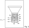
Fig. 3 shows an image of soil layers in the substantially transparent container captured by a camera of the mobile computing device offig. 1 . -
Fig. 4 illustrates a soil texture triangle. -
Fig. 5 illustrates use of the container offig. 1 as a rain gauge. -
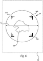
Fig. 6 is a top view of a cap for the container. -
Fig. 1 shows in perspective amobile computing device 10 for determining soil texture according to an embodiment of the present invention. - The
mobile computing device 10 may be handheld and/or portable. Themobile computing device 10 may for example be a smartphone (e.g. an iPhone or an Android phone) or a tablet (e.g. an iPad). - The
mobile computing device 10 comprises a (digital)camera 12. Themobile computing device 10 may also comprise one or more of a(n electronic)display 14, a processor, a memory, a storage, a GPS receiver, and wireless communication means. -
Fig. 1 also shows in side view acontainer 16 according to an embodiment of the present invention. Thecontainer 16 is a (substantially)transparent container 16. The (substantially)transparent container 16 is preferably close to glass in terms of transparency. Thetransparent container 16 may for example be made of clear plastics, such as acrylic. No measuring scale has to be provided on thecontainer 16. - The
transparent container 16 comprises afunnel portion 18 and acylinder portion 20 with a bottom 22. Thefunnel portion 18 may generally have the shape of a(n upside down) truncated cone. Thefunnel portion 18 has a free end opening 24 which is wider (e.g. greater diameter) than anaperture 26 towards thecylinder portion 20. Thecylinder portion 20 is preferably a right circular cylinder portion. Thecylinder portion 20 may have a volume in the range of 400-600 cm3. In an example, thecylinder portion 20 has a radius of 3 cm and a height of 18 cm, whereby the volume is approximately 509 cm3. Thetransparent container 16 is closed or closeable at the free end opening 24 by a cap (lid) 28. - Moving on, the
mobile computing device 10 may be configured to perform various specific steps or actions (e.g. S5-S7) detailed in the following by means of an app 30 (computer program product). Theapp 30 may be downloaded to themobile computing device 10 via the aforementioned wireless communication means and stored on the aforementioned storage. Theapp 30 may run or be executed on themobile computing device 10 using the aforementioned processor and memory. - Turning to
fig. 2, fig. 2 is a flowchart of a method according to one or more embodiments of the present invention. - At S1, the method includes placing
soil 32 and a water-basedliquid 34 in thetransparent container 16. Specifically, a user (farmer or agronomist) may place an amount ofsoil 32 in thetransparent container 16 and then add the water-basedliquid 34 via thefree end opening 24. The volume ofsoil 32 is preferably (somewhat) less than the volume of thecylinder portion 20 of thetransparent container 16. Furthermore, the water-basedliquid 34 could be water or water with added salt (NaCI), for example. - If the
soil 32 is (too) compact, themobile computing device 10/app 30 may instruct the user to initially dry and then grind thesoil sample 32 before placing it in thetransparent container 16. - At S2, the method includes mixing the
soil 32 and the water-basedliquid 34 in thetransparent container 16. This may specifically include closing thetransparent container 16 with thecap 28, and then the user/farmer shakes thetransparent container 16 with itscontent liquid 34. - Then the
transparent container 16 may rest for some time on a flat surface, for example at least two hours or about 1 day, allowing particles of thesoil 32 to separate into layers (segments) 36a-c by gravity, at S3. The layers typically include abottom sand layer 36a, anintermediate silt layer 36b, and atop clay layer 36c. The (residual) water-basedliquid 34 sits above theclay layer 36c. - At S4, the method includes capturing an
image 38 of thelayers 36a-c in thetransparent container 16 by means of thecamera 12 of themobile computing device 10. Before this, themobile computing device 10/app 30 may instruct the user to capture such animage 38, for example by displaying an appropriate message on thedisplay 14. Furthermore, theapp 30 may here display on the display 14 ashape 40 corresponding to at least a portion of the shape of thetransparent container 16, wherein the user positions and/or aims themobile computing device 10 such that thetransparent container 16 as seen in live view by thecamera 12 on thedisplay 14 fits - as good as possible - the displayed shape 40 (like infig. 1 ), and wherein theimage 38 is captured as themobile computing device 10 is so positioned and/or aimed. Theshape 40 may for example be an outline of thetransparent container 16 as seen from the side, i.e. a line that marks the outer limits of thetransparent container 16, or an inverted silhouette of thetransparent container 16. Theshape 40 may be applied as a(n overlaid) filter in the live view on thedisplay 14. - The
app 30 then detects thelayers 36a-c in the capturedimage 38 at S5, and determines the texture of thesoil 32 based on the detected layers 36a-c at S6. The determined texture of the soil 32 (soil texture classification), for example 'loamy sand', 'loam', 'silt', 'sandy clay loam' etc., may be displayed on thedisplay 14. - By means of the present invention, site specific soil texture determination may be simplified, and also the accuracy of the soil texture determination may be improved over the fully manual technique described in the background section of the present application. That is, the user/farmer can just capture the
image 38 using theirsmartphone 10 and then theapp 30 automatically determines the soil texture. The farmer does not need to know how to calculate percentages of thelayer 36a-c and how to read a soil texture triangle, and potential errors in manually measuring the height of thelayers 36a-c, calculating the percentages and/or reading the soil texture triangle may be avoided. Furthermore, no expensive equipment is needed, as the farmer may already have thesmartphone 10 on which theapp 30 may be downloaded. - With further reference to
fig. 3 , detecting thelayers 36a-c in the capturedimage 38 may include determining thethickness 42a-c of eachlayer 36a-c based on the capturedimage 38, and determining the percentage of eachlayer 36a-c relative the complete amount ofsoil 32 based on thedetermined thicknesses 42a-c. In an example, thedetermined thickness 42a of the sand layer is 410 pixels, thedetermined thickness 42b of the silt is 390 pixels, and thedetermined thickness 42c of the clay layer is 200 pixels, whereby the percentage of sand is 410/(410+390+200)=41%, the percentage of silt is 390/(410+390+200)=39%, and the percentage of clay is 200/(410+390+200)=20%. Once the percentages have been determined, theapp 30 may for example determine the texture of thesoil 32 by consulting a soil texture triangle, which soil texture triangle may be programmed into theapp 30. In the present example, the percentages sand 41%, silt 39%, andclay 20% correspond to the soil texture 'loam'. An example of a soil texture triangle is shown infig. 4 . - Specifically, detecting the
layers 36a-c in the capturedimage 38 may include distinguishing thedelimitations 44a-b between thelayers 36a-c by identifying differences in colour and/or texture (granularity) between thelayers 36a-c. Furthermore, theupper boundary 44c of thetop layer 36c may be detected by identifying difference in colour and/or texture between thelayers 36c and the (residual) water-basedliquid 34. Furthermore, thelower boundary 44d of thebottom layer 36a may be detected by detecting the bottom 22 of thetransparent container 16 directly and account for the material thickness of that bottom 22. - At S7, the method may further comprise the
app 30 providing a fertilizer recommendation based at least partly on the determined texture of thesoil 32. For example on a sandy soil, the fertilizer recommendation may be to apply a small quantity of fertiliser more regularly in order to avoid it to percolate. In a clay soil, the fertilizer recommendation may be a less frequent but larger fertilization. The fertilizer recommendation may for example be shown on thedisplay 14 of themobile computing device 10. - Turning to
fig. 5 , thetransparent container 16 being emptied and without thecap 28 may further be used as a rain gauge. In this use, thetransparent container 16 may be placed for example in a field. Here, animage 46 ofrain 48 in thetransparent container 16 can be captured by means of thecamera 12 of themobile computing device 10, wherein theapp 30 determines the amount ofrain 48 in thetransparent container 16 based on that capturedimage 46. The amount ofrain 48 in thetransparent container 16 could be determined in the same way(s) as thelayers 36a-c discussed above. The amount ofrain 46 may for example be the volume of rain or the height H expressed in mm. The volume of rain may be calculated based on the height and the volume or the (base) area of thecylinder portion 20, which volume or (base) area may be known to theapp 30. - Furthermore, push notifications could conveniently be sent to the
mobile computing device 10 via the app 30 (and using the wireless communication means), prompting the user/famer to check thetransparent container 16 based on a past weather forecast of rain, as illustrated by 50. Furthermore, the determined amount of rain could readily and automatically be fed back from theapp 30 andmobile computing device 10 to a weather forecast provider by means of the wireless communication means, as illustrated by 52. - It may be an advantage to know the exact amount of rain that fell on a field to provide accurate fertilizer recommendations, for example in S7. A field well supplied in rain may require more fertilizer to obtain high yield. Over-abundant rain may also lead to nutrient leaching, i.e. excess water in the field may absorb nutrients present in the soil and carry these out of the field. Again, the
app 30 may take this into consideration when delivering a fertilizer recommendation to the user. - Moving on to
fig. 6 , thecap 28 for thetransparent container 16 may have a colour chart known to theapp 30. The colour chart may for example be ared marker 54a, agreen marker 54b, and ablue marker 54c on thecap 28. Here, animage 56 of anobject 58 with at least a portion of thecap 28 as background and with themarkers 54a-c visible may be captured by means of thecamera 12 of themobile computing device 10, wherein theapp 30 may assess the colour of theobject 58 based on that capturedimage 56 taking into account those known colours of thecap 28. Assessing the colour of theobject 58 may include detecting a colour difference between the colour chart as depicted in the capturedimage 56 and the known colour chart of thecap 28, and using the detected difference as calibration to assess the (true) colour of theobject 58. If for example the imagedmarker 54c comes off more bluish than specified, theapp 30 may reduce the blue component of the imaged colour of theobject 58 to determine or assess the true colour of theobject 58. Theobject 58 could for example be soil (like soil 32), whereby the colour assessment can be combined with the determined soil texture and corresponding GPS coordinates (given by the GPS receiver of the mobile computing device 10). These data may in turn be used to build a soil colour-texture map. - Alternatively or complementary, the
cap 28 for thetransparent container 16 may have a size known to theapp 30. The known size may for example be the diameter D of thecap 28. Here, an image (like image 56) of an object (like object 58) placed on thecap 28 and with at least a portion of thecap 28 as background and with the known size D visible may be captured by means of thecamera 12 of themobile computing device 10, wherein theapp 30 may assess the size of theobject 56 based on that captured image taking into account that known size D of thecap 28. For example, if the imagedobject 58 has a width of 600 pixels and the imaged diameter D is 800 pixels, then the is assessed size (width) of theobject 56 is (600/800)*10 cm=7.5 cm given a known size D=10 cm. - The person skilled in the art realizes that the present invention by no means is limited to the embodiments described above. On the contrary, many modifications and variations are possible within the scope of the appended claims.
- Furthermore, both using the container as a rain gauge (e.g. claim 10) and using the cap for assessing colour and/or size of an object (e.g. claim 11, 12, 13) could be implemented independently of the soil texture determination.
Claims (19)
- A method for determining soil texture, comprising:placing soil (32) and a water-based liquid (34) in a substantially transparent container (16);mixing the soil and water-based liquid in the substantially transparent container;allowing particles of the soil to separate into layers (36a-c) by gravity;capturing an image (38) of the layers in the substantially transparent container by means of a camera (12) of a mobile computing device (10); andan app (30) of the mobile computing device detecting the layers in the captured image and determining the texture of the soil based on the detected layers.
- A method according to claim 1, wherein detecting the layers in the captured image includes determining the thickness (42a-c) of each layer based on the captured image and determining the percentage of each layer based on the determined thicknesses.
- A method according to claim 1 or 2, wherein detecting the layers in the captured image includes distinguishing at least one delimitation (44a-b) between the layers by identifying differences in colour between the layers.
- A method according to any one of the preceding claims, wherein detecting the layers in the captured image includes distinguishing at least one delimitation (44a-b) between the layers by identifying differences in texture, in particular granularity, between the layers.
- A method according to any one of the preceding claims, wherein said layers include a sand layer (36a), a silt layer (36b), and a clay layer (36c).
- A method according to any one of the preceding claims, wherein the app displays on a display (14) of the mobile computing device a shape (40) corresponding to at least a portion of the shape of the substantially transparent container, wherein a user positions and/or aims the mobile computing device such that the substantially transparent container as seen in live view by the camera on the display fits the displayed shape, and wherein the image of the layers in the substantially transparent container is captured as the mobile computing device is so positioned and/or aimed.
- A method according to any one of the preceding claims, wherein the substantially transparent container comprises a funnel portion (18) emptying into a cylinder portion (20) with a bottom (22).
- A method according to any one of the preceding claims, further comprising:
the app providing a fertilizer recommendation based at least partly on the determined texture of the soil. - A method according to any one of the preceding claims, wherein the mobile computing device is a smartphone or a tablet.
- A method according to any one of the preceding claims, further comprising:using the substantially transparent container being emptied as a rain gauge;capturing an image (46) of rain (48) in the substantially transparent container by means of the camera of the mobile computing device; andthe app determining the amount of rain in the substantially transparent container based on the captured image of rain in the substantially transparent container.
- A method according to any one of the preceding claims, wherein the substantially transparent container is closed or closable by a cap (28) having at least one of a colour chart (54a-c) known to the app and a size (D) known to the app.
- A method according to claim 11, further comprising:capturing an image (56) of an object (58) with at least a portion of the cap as background by means of the camera of the mobile computing device; andthe app assessing the colour of the object based on the captured image of the object taking into account the known colour chart of the cap and/or assessing the size of the object based on the captured image of the object taking into account the known size of the cap.
- A method according to claim 12, wherein assessing the colour of the object based on the captured image of the object taking into account the known colour chart of the cap includes detecting a colour difference between the colour chart of the cap as depicted in the captured image of the object and the known colour chart of the cap, and using the detected difference as calibration to assess the colour of the object.
- A mobile computing device (10) for determining soil texture, which mobile computing device comprises a camera (12), wherein the mobile computing device is configured to:instruct a user of the mobile computing device to capture an image (38) of soil layers (36a-c) in a substantially transparent container (16) using the camera;detect the soil layers in a captured image (38) of the soil layers in the substantially transparent container; anddetermine a soil texture based on the detected soil layers.
- A computer program product (30) comprising computer program code to perform, when executed on a computer (10), the steps of:receiving an image (38) of soil layers (36a-c) in a substantially transparent container captured by a camera (12) of a mobile computing device (10);detecting the soil layers in the received image; anddetermining a soil texture based on the detected soil layers.
- A computer-readable storage medium comprising the computer program product according to claim 15.
- An electrical signal embodied on a carrier wave and propagated on an electrical medium, the electrical signal comprising the computer program product according to claim 15.
- A mobile computing device (10) comprising the computer-readable storage medium according to claim 16.
- A mobile computing device according to claim 14 or 18 in combination with the substantially transparent container.
Priority Applications (5)
| Application Number | Priority Date | Filing Date | Title |
|---|---|---|---|
| EP20181633.7A EP3929580A1 (en) | 2020-06-23 | 2020-06-23 | Method for determining soil texture |
| PCT/EP2021/066272 WO2021259733A1 (en) | 2020-06-23 | 2021-06-16 | Method for determining soil texture |
| BR112022021978A BR112022021978A2 (en) | 2020-06-23 | 2021-06-16 | MOBILE COMPUTING METHOD AND DEVICE FOR DETERMINING SOIL TEXTURE AND COMPUTER PROGRAM PRODUCT |
| CN202180039507.6A CN115917314B (en) | 2020-06-23 | 2021-06-16 | Methods used to determine soil texture |
| EP21734101.5A EP4168796B1 (en) | 2020-06-23 | 2021-06-16 | Method for determining soil texture |
Applications Claiming Priority (1)
| Application Number | Priority Date | Filing Date | Title |
|---|---|---|---|
| EP20181633.7A EP3929580A1 (en) | 2020-06-23 | 2020-06-23 | Method for determining soil texture |
Publications (1)
| Publication Number | Publication Date |
|---|---|
| EP3929580A1 true EP3929580A1 (en) | 2021-12-29 |
Family
ID=71138530
Family Applications (2)
| Application Number | Title | Priority Date | Filing Date |
|---|---|---|---|
| EP20181633.7A Withdrawn EP3929580A1 (en) | 2020-06-23 | 2020-06-23 | Method for determining soil texture |
| EP21734101.5A Active EP4168796B1 (en) | 2020-06-23 | 2021-06-16 | Method for determining soil texture |
Family Applications After (1)
| Application Number | Title | Priority Date | Filing Date |
|---|---|---|---|
| EP21734101.5A Active EP4168796B1 (en) | 2020-06-23 | 2021-06-16 | Method for determining soil texture |
Country Status (4)
| Country | Link |
|---|---|
| EP (2) | EP3929580A1 (en) |
| CN (1) | CN115917314B (en) |
| BR (1) | BR112022021978A2 (en) |
| WO (1) | WO2021259733A1 (en) |
Citations (3)
| Publication number | Priority date | Publication date | Assignee | Title |
|---|---|---|---|---|
| EP2490177A2 (en) * | 2011-02-16 | 2012-08-22 | Casio Computer Co., Ltd. | Portable device, observation management system, and computer-readable medium |
| WO2017034493A1 (en) * | 2015-08-24 | 2017-03-02 | Orhan Umut | Soil texture analyzer |
| US20180313747A1 (en) * | 2017-04-28 | 2018-11-01 | The Royal Institution For The Advancement Of Learning/Mcgill University | Apparatus for analyzing a sample of granular material |
Family Cites Families (7)
| Publication number | Priority date | Publication date | Assignee | Title |
|---|---|---|---|---|
| KR20060130657A (en) * | 2004-03-18 | 2006-12-19 | 후지 샤신 필름 가부시기가이샤 | Analytical Factors Used in Specimen Testing Methods |
| CN101813690B (en) * | 2010-05-11 | 2012-10-24 | 河海大学 | Testing device for simulating warp self-weight settlement consolidation process by settlement column indoors |
| CN104011769A (en) * | 2011-12-21 | 2014-08-27 | Sca卫生用品公司 | Method For Measuring The Absorption Of Fluid In An Absorbent Product |
| CN102879397A (en) * | 2012-03-05 | 2013-01-16 | 北京师范大学 | Field digital diagnosis recording instrument for soil Montessori color-texture (i-DSCT) |
| EP3014315B1 (en) * | 2013-06-27 | 2022-08-03 | CGG Services SAS | Fracability measurement method and system |
| AU2016350155B2 (en) * | 2015-11-08 | 2021-08-19 | Agrowing Ltd | A method for aerial imagery acquisition and analysis |
| EP3449234B1 (en) * | 2016-04-27 | 2020-09-02 | Ventana Medical Systems, Inc. | System and method for real-time volume control on microscope slides |
-
2020
- 2020-06-23 EP EP20181633.7A patent/EP3929580A1/en not_active Withdrawn
-
2021
- 2021-06-16 BR BR112022021978A patent/BR112022021978A2/en unknown
- 2021-06-16 WO PCT/EP2021/066272 patent/WO2021259733A1/en not_active Ceased
- 2021-06-16 EP EP21734101.5A patent/EP4168796B1/en active Active
- 2021-06-16 CN CN202180039507.6A patent/CN115917314B/en active Active
Patent Citations (3)
| Publication number | Priority date | Publication date | Assignee | Title |
|---|---|---|---|---|
| EP2490177A2 (en) * | 2011-02-16 | 2012-08-22 | Casio Computer Co., Ltd. | Portable device, observation management system, and computer-readable medium |
| WO2017034493A1 (en) * | 2015-08-24 | 2017-03-02 | Orhan Umut | Soil texture analyzer |
| US20180313747A1 (en) * | 2017-04-28 | 2018-11-01 | The Royal Institution For The Advancement Of Learning/Mcgill University | Apparatus for analyzing a sample of granular material |
Also Published As
| Publication number | Publication date |
|---|---|
| CN115917314A (en) | 2023-04-04 |
| EP4168796A1 (en) | 2023-04-26 |
| BR112022021978A2 (en) | 2022-12-27 |
| EP4168796B1 (en) | 2024-05-22 |
| WO2021259733A1 (en) | 2021-12-30 |
| CN115917314B (en) | 2025-05-30 |
Similar Documents
| Publication | Publication Date | Title |
|---|---|---|
| US11003943B2 (en) | Systems and methods for processing images with edge detection and snap-to feature | |
| US9989952B2 (en) | Image calibration | |
| Purinton et al. | Introducing PebbleCounts: a grain-sizing tool for photo surveys of dynamic gravel-bed rivers | |
| CN101561273B (en) | Geographical data collecting device | |
| Nežerka et al. | Assessment of aggregate-bitumen coverage using entropy-based image segmentation | |
| US10655408B2 (en) | Mobile proppant recognition | |
| US10125464B2 (en) | Photogrammetric soil density system and method | |
| KR101793262B1 (en) | Analysis system for occurrence and growth progression of crack | |
| EP4150327B1 (en) | Method of evaluating the quality of a color reference card | |
| US20080027648A1 (en) | Detection-Object-Position-Specifying Device and Method of Specifying Position of Object to Be Detected | |
| CN100596330C (en) | Intelligent identification method of metallurgical mine phase | |
| CN202267464U (en) | Mobile phone based device for rapidly detecting blade area | |
| EP4168796B1 (en) | Method for determining soil texture | |
| CN115639118A (en) | Method and device for identifying particle size and volume of crushed stone based on artificial intelligence | |
| CN113177949A (en) | Large-size rock particle feature identification method and device | |
| CN117456388A (en) | Geological measurement and remote sensing data fusion management system based on unmanned aerial vehicle | |
| CN116630204A (en) | Remote sensing image online analysis processing system | |
| CN113409270B (en) | Coarse aggregate particle size distribution analysis method, device and system | |
| US10240922B2 (en) | Integrated auto-level and electronic rod reader | |
| Razali et al. | Quantitative weathering assessment of rock slope using CIELAB color space and image analysis technique | |
| Lin et al. | Landslide identification and information extraction based on optical and multispectral uav remote sensing imagery | |
| CN110456804A (en) | A method of aerial photogrammetry controlled by mobile phone APP | |
| US9354057B2 (en) | Electronic rod reader and field notebook | |
| Dipova | Automated strain measurements in uniaxial testing via computer vision | |
| Mercier et al. | Literature review of mobile phone applications for forest inventory |
Legal Events
| Date | Code | Title | Description |
|---|---|---|---|
| PUAI | Public reference made under article 153(3) epc to a published international application that has entered the european phase |
Free format text: ORIGINAL CODE: 0009012 |
|
| STAA | Information on the status of an ep patent application or granted ep patent |
Free format text: STATUS: THE APPLICATION HAS BEEN PUBLISHED |
|
| AK | Designated contracting states |
Kind code of ref document: A1 Designated state(s): AL AT BE BG CH CY CZ DE DK EE ES FI FR GB GR HR HU IE IS IT LI LT LU LV MC MK MT NL NO PL PT RO RS SE SI SK SM TR |
|
| B565 | Issuance of search results under rule 164(2) epc |
Effective date: 20210118 |
|
| STAA | Information on the status of an ep patent application or granted ep patent |
Free format text: STATUS: THE APPLICATION IS DEEMED TO BE WITHDRAWN |
|
| 18D | Application deemed to be withdrawn |
Effective date: 20220630 |