EP3635612B1 - Verfahren und system zur identifizierung von mindestens einem sich bewegenden objekt - Google Patents
Verfahren und system zur identifizierung von mindestens einem sich bewegenden objekt Download PDFInfo
- Publication number
- EP3635612B1 EP3635612B1 EP18728653.9A EP18728653A EP3635612B1 EP 3635612 B1 EP3635612 B1 EP 3635612B1 EP 18728653 A EP18728653 A EP 18728653A EP 3635612 B1 EP3635612 B1 EP 3635612B1
- Authority
- EP
- European Patent Office
- Prior art keywords
- vehicle
- target
- track
- determined
- points
- Prior art date
- Legal status (The legal status is an assumption and is not a legal conclusion. Google has not performed a legal analysis and makes no representation as to the accuracy of the status listed.)
- Active
Links
- 238000000034 method Methods 0.000 title claims description 23
- 238000005259 measurement Methods 0.000 claims description 8
- 238000010200 validation analysis Methods 0.000 claims description 8
- 238000013459 approach Methods 0.000 claims description 4
- 238000001514 detection method Methods 0.000 description 6
- 230000006870 function Effects 0.000 description 6
- 238000004364 calculation method Methods 0.000 description 4
- 238000012937 correction Methods 0.000 description 4
- 230000011218 segmentation Effects 0.000 description 4
- 238000012544 monitoring process Methods 0.000 description 3
- 230000000977 initiatory effect Effects 0.000 description 2
- 239000011159 matrix material Substances 0.000 description 2
- 238000012545 processing Methods 0.000 description 2
- 230000002123 temporal effect Effects 0.000 description 2
- 241000861223 Issus Species 0.000 description 1
- 241000607056 Stenodus leucichthys Species 0.000 description 1
- 230000002776 aggregation Effects 0.000 description 1
- 238000004220 aggregation Methods 0.000 description 1
- 238000011161 development Methods 0.000 description 1
- 230000018109 developmental process Effects 0.000 description 1
- 238000006073 displacement reaction Methods 0.000 description 1
- 238000000605 extraction Methods 0.000 description 1
- 238000001914 filtration Methods 0.000 description 1
- 238000013507 mapping Methods 0.000 description 1
- 230000008447 perception Effects 0.000 description 1
- 230000009885 systemic effect Effects 0.000 description 1
Images
Classifications
-
- G—PHYSICS
- G06—COMPUTING; CALCULATING OR COUNTING
- G06V—IMAGE OR VIDEO RECOGNITION OR UNDERSTANDING
- G06V20/00—Scenes; Scene-specific elements
- G06V20/50—Context or environment of the image
- G06V20/56—Context or environment of the image exterior to a vehicle by using sensors mounted on the vehicle
- G06V20/58—Recognition of moving objects or obstacles, e.g. vehicles or pedestrians; Recognition of traffic objects, e.g. traffic signs, traffic lights or roads
Definitions
- the technical field of the invention is the detection and identification of moving objects, in particular motor vehicles.
- LiDAR Light Detection and Ranging
- a target-track association can be carried out based on a nearest neighbor type approach depending on the positions and maximum dimensions of the bounding boxes of each target and each track, bounding boxes of similar sizes being associated within the limit of a predefined ratio.
- the heading of the object can be updated based on the measurement of the orientation of the segments combined with the trajectory of the object.
- Vehicle types may include a two-wheeled vehicle, a car or a truck.
- the invention also relates to a system for classifying at least one object to be classified around a motor vehicle comprising at least one scanning laser rangefinder connected to calculation means capable of carrying out the steps of the method described above .
- This process has the advantage of determining not only the type of object perceived but also other attributes such as the speed and heading of the objects. Updating the evolution model of objects when they are classified as vehicles ensures more precise temporal tracking of their movement.
- the classification system for at least one object to be classified around a motor vehicle comprises a calculation means and at least one scanning laser range finder each providing a two-dimensional point cloud providing information on the shapes of objects in the environment.
- laser rangefinders work by measuring the distance in time of flight of a light pulse emitted from the sensor and reflected by the nearest surface in a given direction.
- a scan following an azimuth discretization is carried out and for each angle step corresponding to an azimuth, a distance measurement is obtained.
- a cloud of two-dimensional points corresponding to all the measurements taken during the scanning on a horizontal plane is provided directly at the output of the LiDAR sensor.
- the scanning laser rangefinders are positioned on the vehicle according to a topology allowing, preferably, to form the widest possible perception belt around the vehicle by favoring a symmetry of this zone in relation to the front axis.
- the calculation means aggregates and processes the point clouds in order to detect and classify objects in the environment.
- a list of objects in the environment as well as their attributes is published by the calculator for client applications.
- attributes we mean the position coordinates of the laser impacts relative to the laser rangefinder.
- the calculation means is capable of carrying out the process steps of determining the type of at least one vehicle as described below
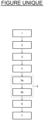
- the method for determining at least one type of vehicle is illustrated by the single figure in which it can be seen that it comprises a first step 1 during which the point clouds acquired by each laser range finder are grouped together, a second step 2 during which sets of points are determined among the pooled point clouds, a third step 3 during which targets are determined based on the sets of points, a fourth step 4 during which we determine target and track association information, a fifth step 5 during which segments are determined based on the sets of points, a sixth step 6 during which a classification of objects around the vehicle is determined based on the segments , targets and target association information and tracks, and a seventh step 7 during which the tracks are updated according to the classification of objects around the vehicle.
- the point clouds determined by the scanning laser rangefinders are grouped together in the same spatial reference frame. Indeed, it is necessary to carry out an aggregation of the point clouds in order to compensate for the differences in relative positions of each laser rangefinder in relation to the vehicle and the other rangefinders.
- the points of each rangefinder are expressed in a reference point originating from the rangefinder itself. Taking into account the fact that each rangefinder is positioned at a different location on the vehicle, it appears that the points obtained by each rangefinder cannot simply be pooled together otherwise they will no longer correspond to reality. To avoid such a situation, all the points determined by each telemeter are transposed into a common reference frame centered on the vehicle so that all the points determined by all the telemeters are expressed from the same reference, for example the barycenter of the vehicle.
- each set of nearby points is assigned to a measurement object called “target”.
- the impacts measured by the laser rangefinder are often related (within a short distance), the threshold distance used during grouping makes it possible to separate the objects directly from the point cloud.
- segmentation processing of the sets of points is carried out leading to the determination of lists of segments which are associated with each set of nearby points.
- segment we mean a line delimited by two points at its ends, each point being located in a two-dimensional space.
- Segmentation processing attempts to associate segments with each set of points in order to obtain an approximation of its shape.
- the associated variance criterion is the dimension of the minor axis of the variance ellipse associated with the set of points. This criterion can be adjusted more finely by those skilled in the art.
- the variance criterion is compared to a predefined limit to determine the suitability of the segment to the point cloud. If the variance criterion is greater than the limit, it is determined that this segment must be divided into two parts because the set of points does not respect the predetermined limit for the criterion. The division point is determined by minimizing the sum of the variances of the two new segments thus created.
- a segment list is a set of segments associated with a set of points.
- the segmentation step has two major advantages: it is not very sensitive to noise on the position of the points and is not a function of the direction of travel of the list of points by the algorithm.
- a track tracking step is carried out comprising a first track prediction sub-step 5a, a second target-track association sub-step 5b and a third track-tracking sub-step 5c. the existence of tracks and targets.
- a “tracking” step (also called “tracking” in English) makes it possible to follow the movement of objects over time. Objects tracked over time are called “tracks”. This step is based on the use of Kalman filtering and a “nearest neighbor” target-track association technique.
- the track following process makes it possible to recalculate certain track attributes such as the heading and/or the speed vector.
- the tracks also ensure the temporal monitoring of other properties including: confidence in the existence, the type of vehicle detected as well as the variance/covariance matrices characterizing the imprecision of the state vector.
- the state vector can include for example the coordinates of the track (x,y), the heading angle of the track, also defined as the angle of the segments of the track with a reference direction.
- the state vector also includes the associated speeds, namely the longitudinal speed, the transverse speed, and the rotation speed which are the derivatives with respect to time of the track coordinates and the track heading. Speeds are estimated for example using the Kalman filter.
- the Kalman filter is adapted to take into account a model of evolution more faithful to the movement of road vehicles (function of heading angle). Otherwise a displacement model independent of the heading angle is used.
- the tracking step employs a Kalman filter which is decomposed into two sets of equations: the prediction equations and the correction equations.
- Prediction equations make it possible to predict (extrapolate) the state vector of an object (track) as well as the variance / covariance matrix associated with a date t (according to the time difference with the previous iteration).
- the prediction equations make it possible, as a first approach, to predict the position of the tracks at the current time during track prediction sub-step 5a.
- the correction equations make it possible to correct the state vector of a track using the information provided by the state vector of a measurement (target). This correction tends to compensate for the error on the predicted state vector by using the most precise data (lowest variance/covariance matrix) between the information from the prediction of the track and that from the measurement.
- the correction equations therefore correct the predicted positions of the tracks using the information from the targets received in step 7 of updating the tracks described below.
- the Kalman filter can also serve as an estimator in the sense that it is, under certain conditions, capable of re-estimating the value of certain unmeasured parameters. This is the case here with regard to longitudinal, transverse and rotational speeds.
- the state of the tracks at the current iteration is determined as a function of the state of the tracks at the previous iteration and the predictive equations of the Kalman filter.
- a target-track association is carried out based on a nearest neighbor type approach (“Global Nearest Neighbor” in English) based on the comparison of the positions between targets and tracks.
- the maximum bounding box dimensions of a target and a track are also compared, with bounding boxes of similar sizes being allowed to be associated. If the ratio between the maximum dimension of the target and the maximum dimension of the associated track exceeds a predefined value then the association is invalidated.
- a target has not been associated with a track. If this is the case, we create a new track to which we associate said target and which inherits the criteria of the associated target, in particular the dimensions of the bounding box.
- a classification of the objects is carried out according to the segments, the targets and the association information of the targets and the tracks, in order to identify, if possible, the type of vehicle corresponding to the object.
- the classification is carried out after the third sub-step 5c of monitoring the existence of tracks and targets and before step 7 of updating the tracks. Indeed, this systemic arrangement makes it possible to know which track a target is associated with and thus to obtain the corresponding speed vector, the latter being used for classification.
- the classification is based on the combination of different criteria characterizing the objects perceived including the absolute speed of the track, and if available, the estimated width of the track, the estimated length of the track, the agreement between the direction of the speed vector and the segment characterizing the rear or front of the vehicle, and the agreement between the direction of the speed vector and the segment characterizing the side.
- Candidate segments are determined for the rear (or front) and/or one side in the list of segments relating to each target and therefore to the associated track. These segments are called “candidates” if they have a length likely to represent either the rear (or front) or the side of a vehicle and if their orientation is compatible with the speed vector of the track (parallel to the velocity vector if the candidate segment is likely to represent a side and perpendicular if the candidate segment is likely to represent the rear or the front).
- the absolute speed of the track is also compared to a range of values stored for the category of object tested.
- a criterion as a particular characteristic of an object among its width, its length, the value of its absolute speed, the angular difference between its trajectory and a segment characterizing the rear (or the front) as well as the angular difference between its trajectory and a segment characterizing a lateral side of the object
- a category is defined as being chosen from at least one type of vehicle among “two wheels”, “car”, “truck”.
- Each initial mass thus takes a value based on the comparison of the associated criterion with the associated range of admissible values.
- a range of admissible values includes a minimum value below which the target cannot be of the type of vehicle tested, a maximum value above which the target cannot be of the type of vehicle tested, and a low value and a high value between which the target is, with certainty, the type of vehicle tested. Between the minimum and low values and between the maximum and high values, the probability that the target is of the type of vehicle tested varies between the fact that the target is not of the type of vehicle tested and the fact that the target is of the type of vehicle tested of vehicle tested.
- the index 1..K qualifying the masses of the quadruplet ⁇ m 1..K (H), m 1..K (/H), m 1..K ( ⁇ ), m 1..K ( ⁇ ) ⁇ means that all of the K criteria were taken into account when generating these masses.
- the index 1..J qualifying the masses ⁇ m 1..J (H j ), mi..j(H*), m 1..J ( ⁇ ), m 1..J ( ⁇ ) ⁇ means that all of the J categories were taken into account when generating these masses.
- BetP H j 1 1 ⁇ m 1 . . J AE ⁇ m 1 . . J H j + 1 ⁇ ⁇ ⁇ ⁇ m 1 . . J ⁇ + m 1 . . J H ⁇
- step 7 of updating the tracks during which, if the object is associated with a type of vehicle, we update the heading angle of the object based on the measurement of the orientation of the segments combined with the object's trajectory.
- Target tracking step 5 is then adapted to take into account a “vehicle” evolution model taking into account the heading angle for the estimation of the movement.
- steps 1 to 7 are executed in a loop.
Landscapes
- Engineering & Computer Science (AREA)
- Physics & Mathematics (AREA)
- General Physics & Mathematics (AREA)
- Multimedia (AREA)
- Theoretical Computer Science (AREA)
- Traffic Control Systems (AREA)
Claims (7)
- Verfahren zur Klassifizierung mindestens eines zu klassifizierenden Objekts um ein Kraftfahrzeug herum, das mindestens einen Laserentfernungsmesser umfasst, umfassend die folgenden Schritte:für jeden mindestens einen Laserentfernungsmesser wird eine Punktwolke erfasst, die mindestens zwei Punkte umfasst, die aus dem Auftreffen des Lasers auf mindestens ein zu klassifizierendes Objekt herrühren,die von jedem Laserentfernungsmesser erfassten Punktwolken werden in einem einzigen Bezugssystem zusammengefasst,es werden Punktmengen unter den zusammengelegten Punktwolken in Abhängigkeit von ihren jeweiligen Koordinaten und von einem maximalen Abstand zwischen Punkten bestimmt,für jede Punktmenge wird ein Ziel bestimmt, das durch Kriterien definiert wird, umfassend insbesondere eine Bounding-Box, die die Punktmenge und einen Boxmittelpunkt umschließt,für jedes Ziel wird eine Liste mit Segmenten bestimmt, die sich der Form der Kontur der entsprechenden Punktmenge möglichst nah anpassen,es wird eine Prädiktion eines Weges durchgeführt, der das Vorhandensein und die Bewegung des Objekts im Laufe der Zeit kennzeichnet, indem der Zustand der Wege bei der aktuellen Iteration in Abhängigkeit von dem Zustand der Wege bei der vorhergehenden Iteration und von prädiktiven Gleichungen des Kalman-Filters bestimmt wird,jedes Ziel wird mindestens einem Weg zugeordnet, wobei der Weg die Kriterien des Ziels erwirbt,es werden Informationen zur Zuordnung der Ziele und der Wege in Abhängigkeit von der Position des Mittelpunkts und von den Abmessungen der jedem Ziel und jedem Weg zugeordneten Bounding-Box bestimmt,es wird eine Klassifizierung der zu klassifizierenden Objekte unter mehreren Kategorien in Abhängigkeit von den Segmentlisten und von mindestens einem Wert von Kriterien, die die Objekte kennzeichnen, bestimmt, um den jedem Objekt entsprechenden Fahrzeugtyp zu bestimmen, unddie Wege werden in Abhängigkeit von der Klassifizierung der Objekte um das Fahrzeug herum aktualisiert, indem der korrigierende Teil der Gleichungen des Kalman-Filters auf die Kriterien angewandt wird, die die Objekte um das Fahrzeug herum beschreiben,dadurch gekennzeichnet, dass zum Durchführen der Klassifizierung der Objekte die folgenden Schritte durchgeführt werden:es werden Kandidatensegmente für das Heck und/oder den Bug und/oder eine Seite des Ziels in der Segmentliste bezüglich jedes Ziels und somit des zugeordneten Wegs bestimmt,es werden mindestens zwei kennzeichnende Werte erhalten, umfassend die absolute Geschwindigkeit des durch den prädiktiven Teil des Kalman-Filters geschätzten Wegs und, wenn sie verfügbar sind, die geschätzte Breite des Wegs, die geschätzte Länge des Wegs, die Übereinstimmung zwischen der Richtung des Geschwindigkeitsvektors und dem Segment, welches das Heck oder den Bug des Fahrzeugs kennzeichnet, und die Übereinstimmung zwischen der Richtung des Geschwindigkeitsvektors und dem Segment, das die Seite des Fahrzeugs kennzeichnet, wobei jeder erhaltene kennzeichnende Wert als Klassifizierungskriterium verwendet wird,für jedes Kriterium und für jede Kategorie wird ein Tripel von Anfangsmassen erzeugt, die die Ähnlichkeit, die Nichtähnlichkeit und die Unsicherheit für die Tatsache, dass das Objekt einer Kategorie gemäß einem Kriterium angehört, kennzeichnen, indem der Wert des Kriteriums mit einem Bereich zugeordneter vorgegebener wahrscheinlicher Werte verglichen wird,für jede Kategorie wird ein Quadrupel von Massen bestimmt, die die Ähnlichkeit, die Nichtähnlichkeit, die Unsicherheit beziehungsweise den Konflikt in Bezug auf die Zugehörigkeit des Ziels zu der getesteten Kategorie kennzeichnen, indem die Tripel von Anfangsmassen bezüglich jedes der getesteten Kriterien durch die Verwendung eines auf der Evidenztheorie basierenden multikriteriellen Kombinationsoperators kombiniert werden,es wird ein Satz von Massen bestimmt, indem man eine Multi-Objekt-Kombination der für jede Kategorie bestimmten Quadrupel von Massen durchgeführt wird, um zu bestimmen, ob die Kategorien konfliktbehaftet, mehrdeutig sind oder ob das Objekt einer nicht gelisteten Kategorie angehört,die pignistische Wahrscheinlichkeit wird in Abhängigkeit von diesem Satz von Massen für jede Kategorie berechnet, die unter den Fahrzeugtypen, "andere Kategorie" oder "unbekannt" gewählt ist,wenn die höchste pignistische Wahrscheinlichkeit einer Fahrzeugtypkategorie entspricht, wird bestimmt, dass das Objekt ein Fahrzeug ist, das dem Fahrzeugtyp entspricht, dessen pignistische Wahrscheinlichkeit die höchste ist und über einem vorbestimmten Validierungsschwellenwert liegt, wenn keine pignistische Wahrscheinlichkeit über dem vorbestimmten Validierungsschwellenwert liegt, kann keine Auswahl unter den Fahrzeugtypen vorgenommen werden.
- Verfahren nach dem vorhergehenden Anspruch, bei dem, zum Bestimmen einer Liste mit Segmenten für jedes Ziel, eine Liste mit Segmenten bestimmt wird, die sich der Form der Kontur der Punktmenge möglichst nah anpassen,ein Varianzkriterium für jedes Segment bestimmt wird, das gleich der Abmessung der kleinsten Achse der Varianzellipse ist, die der Punktmenge zugeordnet ist, bestimmt wird, ob das Varianzkriterium über einem vorgegebenen Grenzwert liegt, um die Eignung des Segments für die Punktwolke zu bestimmen,wenn dies der Fall ist, bestimmt wird, dass dieses Segment in zwei Teile geteilt werden muss, weil die Punktmenge den für das Kriterium vorbestimmten Grenzwert nicht erfüllt,der Teilungspunkt des Segments so bestimmt wird, dass die Summe der Varianzen der beiden durch die Teilung geschaffenen neuen Segmente minimiert wird.
- Verfahren nach einem der vorhergehenden Ansprüche, bei dem, zum Bestimmen der Informationen zur Zuordnung von Zielen und Wegen, eine auf einem Global-Nearest-Neighbour-Ansatz beruhende Ziel-Bahn-Zuordnung durchgeführt wird, die von den Positionen und maximalen Abmessungen der Bounding-Boxes jedes Ziels und jedes Wegs abhängig ist, wobei die Bounding-Boxes mit ähnlichen Größen innerhalb der Grenze eines vorgegebenen Verhältnisses zugeordnet werden.
- Verfahren nach einem der vorhergehenden Ansprüche, bei dem, zum Aktualisieren der Wege, wenn ein Fahrzeugtyp bestimmt wird, der Kurs des Objekts in Abhängigkeit von der Messung der Ausrichtung der mit dem Bahnverlauf des Objekts kombinierten Segmente aktualisiert wird.
- Verfahren nach einem der vorhergehenden Ansprüche, bei dem die Fahrzeugtypen ein zweirädriges Fahrzeug, einen Pkw oder einen Lkw umfassen.
- Verfahren nach einem der vorhergehenden Ansprüche, bei dem, zum Durchführen einer Prädiktion eines Wegs, ein vom Fahrzeugtyp abhängiges Evolutionsmodell berücksichtigt wird, indem der Kurswinkel bei der Schätzung der Bewegung im prädiktiven Teil der Gleichungen des Kalman-Filters berücksichtigt wird.
- System zur Klassifizierung mindestens eines zu klassifizierenden Objekts um ein Kraftfahrzeug herum, das mindestens einen Laserscan-Entfernungsmesser umfasst, der mit einem Rechenmittel verbunden ist, das geeignet ist, die Verfahrensschritte nach einem der vorhergehenden Ansprüche durchzuführen.
Applications Claiming Priority (2)
| Application Number | Priority Date | Filing Date | Title |
|---|---|---|---|
| FR1755086A FR3067495B1 (fr) | 2017-06-08 | 2017-06-08 | Procede et systeme d'identification d'au moins un objet en deplacement |
| PCT/EP2018/065117 WO2018224634A1 (fr) | 2017-06-08 | 2018-06-08 | Procédé et système d'identification d'au moins un objet en déplacement |
Publications (2)
| Publication Number | Publication Date |
|---|---|
| EP3635612A1 EP3635612A1 (de) | 2020-04-15 |
| EP3635612B1 true EP3635612B1 (de) | 2023-12-20 |
Family
ID=59381538
Family Applications (1)
| Application Number | Title | Priority Date | Filing Date |
|---|---|---|---|
| EP18728653.9A Active EP3635612B1 (de) | 2017-06-08 | 2018-06-08 | Verfahren und system zur identifizierung von mindestens einem sich bewegenden objekt |
Country Status (3)
| Country | Link |
|---|---|
| EP (1) | EP3635612B1 (de) |
| FR (1) | FR3067495B1 (de) |
| WO (1) | WO2018224634A1 (de) |
Families Citing this family (12)
| Publication number | Priority date | Publication date | Assignee | Title |
|---|---|---|---|---|
| CN109887013B (zh) * | 2019-01-14 | 2021-06-25 | 苏州数设科技有限公司 | 基于pca的点云配准最终确定方法及系统 |
| CN110220529B (zh) * | 2019-06-17 | 2023-05-23 | 深圳数翔科技有限公司 | 一种路侧自动驾驶车辆的定位方法 |
| CN111259958B (zh) * | 2020-01-15 | 2024-04-16 | 北京市商汤科技开发有限公司 | 物体识别方法及装置、存储介质 |
| CN114170267A (zh) * | 2020-09-10 | 2022-03-11 | 华为技术有限公司 | 目标跟踪方法、装置、设备及计算机可读存储介质 |
| CN112131278B (zh) * | 2020-09-28 | 2024-09-06 | 浙江大华技术股份有限公司 | 轨迹数据的处理方法及装置、存储介质、电子装置 |
| CN112731335B (zh) * | 2020-12-20 | 2023-11-07 | 大连理工大学人工智能大连研究院 | 一种基于全区域激光扫描的多无人机协作定位方法 |
| WO2022141911A1 (zh) * | 2021-01-01 | 2022-07-07 | 杜豫川 | 一种基于路侧感知单元的动态目标点云快速识别及点云分割方法 |
| CN113650616B (zh) * | 2021-07-20 | 2022-11-25 | 武汉光庭信息技术股份有限公司 | 一种基于采集数据的车辆行为预测方法及系统 |
| CN114117064B (zh) * | 2021-11-09 | 2023-05-26 | 西南交通大学 | 一种基于多时间粒度的知识动态演化的城市地铁流量预测方法 |
| CN114462533B (zh) * | 2022-02-08 | 2024-06-25 | 小视科技(江苏)股份有限公司 | 一种群聚性物体聚类方法 |
| CN114879192A (zh) * | 2022-05-17 | 2022-08-09 | 安徽隼波科技有限公司 | 基于路侧毫米波雷达的决策树车型分类方法、电子设备 |
| CN116152576B (zh) * | 2023-04-19 | 2023-08-01 | 北京邮电大学 | 图像处理方法、装置、设备及存储介质 |
Family Cites Families (5)
| Publication number | Priority date | Publication date | Assignee | Title |
|---|---|---|---|---|
| DE19856974C1 (de) | 1998-12-10 | 2000-09-07 | Bosch Gmbh Robert | Verfahren und Vorrichtung zur Erfassung eines Hindernisses |
| US9383753B1 (en) * | 2012-09-26 | 2016-07-05 | Google Inc. | Wide-view LIDAR with areas of special attention |
| US9110163B2 (en) | 2013-06-14 | 2015-08-18 | Microsoft Technology Licensing, Llc | Lidar-based classification of object movement |
| CN103927557B (zh) | 2014-05-08 | 2017-01-18 | 中北大学 | 基于分层模糊证据合成的lidar数据地物分类方法 |
| CN104463872B (zh) | 2014-12-10 | 2018-01-12 | 武汉大学 | 基于车载LiDAR点云数据的分类方法 |
-
2017
- 2017-06-08 FR FR1755086A patent/FR3067495B1/fr active Active
-
2018
- 2018-06-08 EP EP18728653.9A patent/EP3635612B1/de active Active
- 2018-06-08 WO PCT/EP2018/065117 patent/WO2018224634A1/fr unknown
Also Published As
| Publication number | Publication date |
|---|---|
| FR3067495B1 (fr) | 2019-07-05 |
| EP3635612A1 (de) | 2020-04-15 |
| WO2018224634A1 (fr) | 2018-12-13 |
| FR3067495A1 (fr) | 2018-12-14 |
Similar Documents
| Publication | Publication Date | Title |
|---|---|---|
| EP3635612B1 (de) | Verfahren und system zur identifizierung von mindestens einem sich bewegenden objekt | |
| EP3137355B1 (de) | Vorrichtung zur objekt bestimmung an einem navigationsmodul von einem fahrzeug ausgerüstet mit dieser vorrichtung | |
| CN104833370B (zh) | 用于映射、定位和位姿校正的系统和方法 | |
| CN107144839B (zh) | 通过传感器融合检测长对象 | |
| AU2014278279B2 (en) | Lidar-based classification of object movement | |
| US20130332112A1 (en) | State estimation device | |
| EP4176286A1 (de) | System und verfahren zur erkennung eines hindernisses in einem umgebungsbereich eines kraftfahrzeugs | |
| AU2020356082A1 (en) | Vehicle and method for generating map corresponding to three-dimensional space | |
| FR3106918A1 (fr) | Procédé et dispositif de reconstruction des voies | |
| EP3189348B1 (de) | Verfahren zur verwaltung von übergängen bei der verfolgung von beweglichen objekten und zugehörige vorrichtung | |
| JP2019179495A (ja) | センサ処理システム、測距システム、移動体、センサ処理方法及びプログラム | |
| FR3054672B1 (fr) | Procede et systeme d'association de donnees de detection et de suivi d'objets mobile pour vehicule automobile | |
| FR3056531B1 (fr) | Detection d'obstacles pour vehicule automobile | |
| FR3056530B1 (fr) | Detection d'obstacles par fusion d'objets pour vehicule automobile | |
| FR3054673B1 (fr) | Fusion de donnees de detection et de suivi d'objets pour vehicule automobile | |
| EP2452204B1 (de) | Multi-target-datenverarbeitung für multistatischen und multikanal-passivradar | |
| US20240151855A1 (en) | Lidar-based object tracking | |
| FR3101433A1 (fr) | Procédé de détection du sol dans un nuage de points obtenu par télédétection laser 3D | |
| FR3094081A1 (fr) | Procédé d’estimation passive du temps avant collision pour un aéronef ou de tout objet volant pouvant être guidé, procédé de navigation associé | |
| FR3141549A1 (fr) | Procede de detection de vehicules longs ou articules | |
| Kühner et al. | Automatic generation of training data for image classification of road scenes | |
| EP3757943B1 (de) | Verfahren und vorrichtung zur passiven telemetrie durch bildverarbeitung, und verwendung von 3d-modellen | |
| US20230184946A1 (en) | Vehicle Lidar System and Velocity Measuring Method Thereof | |
| WO2022189389A1 (fr) | Procede et dispositif de calibration d'un capteur de profondeur d'environnement | |
| EP3300525A1 (de) | Verfahren zur schätzung geometrischer parameter, die die form einer strasse darstellen, system zur schätzung solcher parameter und mit solch einem system ausgestattetes kraftfahrzeug |
Legal Events
| Date | Code | Title | Description |
|---|---|---|---|
| STAA | Information on the status of an ep patent application or granted ep patent |
Free format text: STATUS: UNKNOWN |
|
| STAA | Information on the status of an ep patent application or granted ep patent |
Free format text: STATUS: THE INTERNATIONAL PUBLICATION HAS BEEN MADE |
|
| PUAI | Public reference made under article 153(3) epc to a published international application that has entered the european phase |
Free format text: ORIGINAL CODE: 0009012 |
|
| STAA | Information on the status of an ep patent application or granted ep patent |
Free format text: STATUS: REQUEST FOR EXAMINATION WAS MADE |
|
| 17P | Request for examination filed |
Effective date: 20200108 |
|
| AK | Designated contracting states |
Kind code of ref document: A1 Designated state(s): AL AT BE BG CH CY CZ DE DK EE ES FI FR GB GR HR HU IE IS IT LI LT LU LV MC MK MT NL NO PL PT RO RS SE SI SK SM TR |
|
| AX | Request for extension of the european patent |
Extension state: BA ME |
|
| DAV | Request for validation of the european patent (deleted) | ||
| DAX | Request for extension of the european patent (deleted) | ||
| STAA | Information on the status of an ep patent application or granted ep patent |
Free format text: STATUS: EXAMINATION IS IN PROGRESS |
|
| 17Q | First examination report despatched |
Effective date: 20211201 |
|
| RAP3 | Party data changed (applicant data changed or rights of an application transferred) |
Owner name: INSTITUT FRANCAIS DES SCIENCES ET TECHNOLOGIES DES TRANSPORTS DE L'AMENAGEMENT ET DES RESEAUX (IFSTTAR) Owner name: RENAULT S.A.S |
|
| RAP3 | Party data changed (applicant data changed or rights of an application transferred) |
Owner name: INSTITUT FRANCAIS DES SCIENCES ET TECHNOLOGIES DES TRANSPORTS DE L'AMENAGEMENT ET DES RESEAUX (IFSTTAR) Owner name: RENAULT S.A.S |
|
| REG | Reference to a national code |
Ref document number: 602018062885 Country of ref document: DE Ref country code: DE Ref legal event code: R079 Free format text: PREVIOUS MAIN CLASS: G06K0009000000 Ipc: G06V0020580000 |
|
| GRAP | Despatch of communication of intention to grant a patent |
Free format text: ORIGINAL CODE: EPIDOSNIGR1 |
|
| STAA | Information on the status of an ep patent application or granted ep patent |
Free format text: STATUS: GRANT OF PATENT IS INTENDED |
|
| RIC1 | Information provided on ipc code assigned before grant |
Ipc: G06V 20/58 20220101AFI20230627BHEP |
|
| INTG | Intention to grant announced |
Effective date: 20230720 |
|
| GRAS | Grant fee paid |
Free format text: ORIGINAL CODE: EPIDOSNIGR3 |
|
| GRAA | (expected) grant |
Free format text: ORIGINAL CODE: 0009210 |
|
| STAA | Information on the status of an ep patent application or granted ep patent |
Free format text: STATUS: THE PATENT HAS BEEN GRANTED |
|
| AK | Designated contracting states |
Kind code of ref document: B1 Designated state(s): AL AT BE BG CH CY CZ DE DK EE ES FI FR GB GR HR HU IE IS IT LI LT LU LV MC MK MT NL NO PL PT RO RS SE SI SK SM TR |
|
| REG | Reference to a national code |
Ref country code: GB Ref legal event code: FG4D Free format text: NOT ENGLISH |
|
| REG | Reference to a national code |
Ref country code: CH Ref legal event code: EP |
|
| REG | Reference to a national code |
Ref country code: DE Ref legal event code: R096 Ref document number: 602018062885 Country of ref document: DE |
|
| REG | Reference to a national code |
Ref country code: IE Ref legal event code: FG4D Free format text: LANGUAGE OF EP DOCUMENT: FRENCH |
|
| PG25 | Lapsed in a contracting state [announced via postgrant information from national office to epo] |
Ref country code: GR Free format text: LAPSE BECAUSE OF FAILURE TO SUBMIT A TRANSLATION OF THE DESCRIPTION OR TO PAY THE FEE WITHIN THE PRESCRIBED TIME-LIMIT Effective date: 20240321 |
|
| RAP2 | Party data changed (patent owner data changed or rights of a patent transferred) |
Owner name: INSTITUT FRANCAIS DES SCIENCES ET TECHNOLOGIES DES TRANSPORTS DE L'AMENAGEMENT ET DES RESEAUX (IFSTTAR) Owner name: AMPERE SAS |
|
| REG | Reference to a national code |
Ref country code: LT Ref legal event code: MG9D |
|
| PG25 | Lapsed in a contracting state [announced via postgrant information from national office to epo] |
Ref country code: LT Free format text: LAPSE BECAUSE OF FAILURE TO SUBMIT A TRANSLATION OF THE DESCRIPTION OR TO PAY THE FEE WITHIN THE PRESCRIBED TIME-LIMIT Effective date: 20231220 |
|
| REG | Reference to a national code |
Ref country code: NL Ref legal event code: MP Effective date: 20231220 |
|
| PG25 | Lapsed in a contracting state [announced via postgrant information from national office to epo] |
Ref country code: ES Free format text: LAPSE BECAUSE OF FAILURE TO SUBMIT A TRANSLATION OF THE DESCRIPTION OR TO PAY THE FEE WITHIN THE PRESCRIBED TIME-LIMIT Effective date: 20231220 |
|
| PG25 | Lapsed in a contracting state [announced via postgrant information from national office to epo] |
Ref country code: LT Free format text: LAPSE BECAUSE OF FAILURE TO SUBMIT A TRANSLATION OF THE DESCRIPTION OR TO PAY THE FEE WITHIN THE PRESCRIBED TIME-LIMIT Effective date: 20231220 Ref country code: GR Free format text: LAPSE BECAUSE OF FAILURE TO SUBMIT A TRANSLATION OF THE DESCRIPTION OR TO PAY THE FEE WITHIN THE PRESCRIBED TIME-LIMIT Effective date: 20240321 Ref country code: FI Free format text: LAPSE BECAUSE OF FAILURE TO SUBMIT A TRANSLATION OF THE DESCRIPTION OR TO PAY THE FEE WITHIN THE PRESCRIBED TIME-LIMIT Effective date: 20231220 Ref country code: ES Free format text: LAPSE BECAUSE OF FAILURE TO SUBMIT A TRANSLATION OF THE DESCRIPTION OR TO PAY THE FEE WITHIN THE PRESCRIBED TIME-LIMIT Effective date: 20231220 Ref country code: BG Free format text: LAPSE BECAUSE OF FAILURE TO SUBMIT A TRANSLATION OF THE DESCRIPTION OR TO PAY THE FEE WITHIN THE PRESCRIBED TIME-LIMIT Effective date: 20240320 |
|
| REG | Reference to a national code |
Ref country code: AT Ref legal event code: MK05 Ref document number: 1643124 Country of ref document: AT Kind code of ref document: T Effective date: 20231220 |
|
| PG25 | Lapsed in a contracting state [announced via postgrant information from national office to epo] |
Ref country code: NL Free format text: LAPSE BECAUSE OF FAILURE TO SUBMIT A TRANSLATION OF THE DESCRIPTION OR TO PAY THE FEE WITHIN THE PRESCRIBED TIME-LIMIT Effective date: 20231220 |
|
| PG25 | Lapsed in a contracting state [announced via postgrant information from national office to epo] |
Ref country code: SE Free format text: LAPSE BECAUSE OF FAILURE TO SUBMIT A TRANSLATION OF THE DESCRIPTION OR TO PAY THE FEE WITHIN THE PRESCRIBED TIME-LIMIT Effective date: 20231220 Ref country code: RS Free format text: LAPSE BECAUSE OF FAILURE TO SUBMIT A TRANSLATION OF THE DESCRIPTION OR TO PAY THE FEE WITHIN THE PRESCRIBED TIME-LIMIT Effective date: 20231220 Ref country code: NO Free format text: LAPSE BECAUSE OF FAILURE TO SUBMIT A TRANSLATION OF THE DESCRIPTION OR TO PAY THE FEE WITHIN THE PRESCRIBED TIME-LIMIT Effective date: 20240320 Ref country code: NL Free format text: LAPSE BECAUSE OF FAILURE TO SUBMIT A TRANSLATION OF THE DESCRIPTION OR TO PAY THE FEE WITHIN THE PRESCRIBED TIME-LIMIT Effective date: 20231220 Ref country code: LV Free format text: LAPSE BECAUSE OF FAILURE TO SUBMIT A TRANSLATION OF THE DESCRIPTION OR TO PAY THE FEE WITHIN THE PRESCRIBED TIME-LIMIT Effective date: 20231220 Ref country code: HR Free format text: LAPSE BECAUSE OF FAILURE TO SUBMIT A TRANSLATION OF THE DESCRIPTION OR TO PAY THE FEE WITHIN THE PRESCRIBED TIME-LIMIT Effective date: 20231220 |
|
| PG25 | Lapsed in a contracting state [announced via postgrant information from national office to epo] |
Ref country code: IS Free format text: LAPSE BECAUSE OF FAILURE TO SUBMIT A TRANSLATION OF THE DESCRIPTION OR TO PAY THE FEE WITHIN THE PRESCRIBED TIME-LIMIT Effective date: 20240420 |
|
| PGFP | Annual fee paid to national office [announced via postgrant information from national office to epo] |
Ref country code: GB Payment date: 20240621 Year of fee payment: 7 |
|
| PGFP | Annual fee paid to national office [announced via postgrant information from national office to epo] |
Ref country code: DE Payment date: 20240619 Year of fee payment: 7 |
|
| PG25 | Lapsed in a contracting state [announced via postgrant information from national office to epo] |
Ref country code: AT Free format text: LAPSE BECAUSE OF FAILURE TO SUBMIT A TRANSLATION OF THE DESCRIPTION OR TO PAY THE FEE WITHIN THE PRESCRIBED TIME-LIMIT Effective date: 20231220 Ref country code: CZ Free format text: LAPSE BECAUSE OF FAILURE TO SUBMIT A TRANSLATION OF THE DESCRIPTION OR TO PAY THE FEE WITHIN THE PRESCRIBED TIME-LIMIT Effective date: 20231220 |
|
| PG25 | Lapsed in a contracting state [announced via postgrant information from national office to epo] |
Ref country code: SK Free format text: LAPSE BECAUSE OF FAILURE TO SUBMIT A TRANSLATION OF THE DESCRIPTION OR TO PAY THE FEE WITHIN THE PRESCRIBED TIME-LIMIT Effective date: 20231220 |
|
| PG25 | Lapsed in a contracting state [announced via postgrant information from national office to epo] |
Ref country code: SM Free format text: LAPSE BECAUSE OF FAILURE TO SUBMIT A TRANSLATION OF THE DESCRIPTION OR TO PAY THE FEE WITHIN THE PRESCRIBED TIME-LIMIT Effective date: 20231220 Ref country code: SK Free format text: LAPSE BECAUSE OF FAILURE TO SUBMIT A TRANSLATION OF THE DESCRIPTION OR TO PAY THE FEE WITHIN THE PRESCRIBED TIME-LIMIT Effective date: 20231220 Ref country code: RO Free format text: LAPSE BECAUSE OF FAILURE TO SUBMIT A TRANSLATION OF THE DESCRIPTION OR TO PAY THE FEE WITHIN THE PRESCRIBED TIME-LIMIT Effective date: 20231220 Ref country code: IT Free format text: LAPSE BECAUSE OF FAILURE TO SUBMIT A TRANSLATION OF THE DESCRIPTION OR TO PAY THE FEE WITHIN THE PRESCRIBED TIME-LIMIT Effective date: 20231220 Ref country code: IS Free format text: LAPSE BECAUSE OF FAILURE TO SUBMIT A TRANSLATION OF THE DESCRIPTION OR TO PAY THE FEE WITHIN THE PRESCRIBED TIME-LIMIT Effective date: 20240420 Ref country code: EE Free format text: LAPSE BECAUSE OF FAILURE TO SUBMIT A TRANSLATION OF THE DESCRIPTION OR TO PAY THE FEE WITHIN THE PRESCRIBED TIME-LIMIT Effective date: 20231220 Ref country code: CZ Free format text: LAPSE BECAUSE OF FAILURE TO SUBMIT A TRANSLATION OF THE DESCRIPTION OR TO PAY THE FEE WITHIN THE PRESCRIBED TIME-LIMIT Effective date: 20231220 Ref country code: AT Free format text: LAPSE BECAUSE OF FAILURE TO SUBMIT A TRANSLATION OF THE DESCRIPTION OR TO PAY THE FEE WITHIN THE PRESCRIBED TIME-LIMIT Effective date: 20231220 |
|
| PGFP | Annual fee paid to national office [announced via postgrant information from national office to epo] |
Ref country code: FR Payment date: 20240628 Year of fee payment: 7 |
|
| PG25 | Lapsed in a contracting state [announced via postgrant information from national office to epo] |
Ref country code: PL Free format text: LAPSE BECAUSE OF FAILURE TO SUBMIT A TRANSLATION OF THE DESCRIPTION OR TO PAY THE FEE WITHIN THE PRESCRIBED TIME-LIMIT Effective date: 20231220 Ref country code: PT Free format text: LAPSE BECAUSE OF FAILURE TO SUBMIT A TRANSLATION OF THE DESCRIPTION OR TO PAY THE FEE WITHIN THE PRESCRIBED TIME-LIMIT Effective date: 20240422 |
|
| PG25 | Lapsed in a contracting state [announced via postgrant information from national office to epo] |
Ref country code: PT Free format text: LAPSE BECAUSE OF FAILURE TO SUBMIT A TRANSLATION OF THE DESCRIPTION OR TO PAY THE FEE WITHIN THE PRESCRIBED TIME-LIMIT Effective date: 20240422 Ref country code: PL Free format text: LAPSE BECAUSE OF FAILURE TO SUBMIT A TRANSLATION OF THE DESCRIPTION OR TO PAY THE FEE WITHIN THE PRESCRIBED TIME-LIMIT Effective date: 20231220 |