EP3399143A1 - Method and device for determining dissolution degree of karst reservoir - Google Patents
Method and device for determining dissolution degree of karst reservoir Download PDFInfo
- Publication number
- EP3399143A1 EP3399143A1 EP16881232.9A EP16881232A EP3399143A1 EP 3399143 A1 EP3399143 A1 EP 3399143A1 EP 16881232 A EP16881232 A EP 16881232A EP 3399143 A1 EP3399143 A1 EP 3399143A1
- Authority
- EP
- European Patent Office
- Prior art keywords
- characteristic
- karst
- horizontal
- reservoir
- vertical
- Prior art date
- Legal status (The legal status is an assumption and is not a legal conclusion. Google has not performed a legal analysis and makes no representation as to the accuracy of the status listed.)
- Ceased
Links
Images

Classifications
-
- E—FIXED CONSTRUCTIONS
- E21—EARTH OR ROCK DRILLING; MINING
- E21B—EARTH OR ROCK DRILLING; OBTAINING OIL, GAS, WATER, SOLUBLE OR MELTABLE MATERIALS OR A SLURRY OF MINERALS FROM WELLS
- E21B49/00—Testing the nature of borehole walls; Formation testing; Methods or apparatus for obtaining samples of soil or well fluids, specially adapted to earth drilling or wells
- E21B49/08—Obtaining fluid samples or testing fluids, in boreholes or wells
- E21B49/087—Well testing, e.g. testing for reservoir productivity or formation parameters
-
- G—PHYSICS
- G06—COMPUTING OR CALCULATING; COUNTING
- G06T—IMAGE DATA PROCESSING OR GENERATION, IN GENERAL
- G06T7/00—Image analysis
- G06T7/40—Analysis of texture
-
- E—FIXED CONSTRUCTIONS
- E21—EARTH OR ROCK DRILLING; MINING
- E21B—EARTH OR ROCK DRILLING; OBTAINING OIL, GAS, WATER, SOLUBLE OR MELTABLE MATERIALS OR A SLURRY OF MINERALS FROM WELLS
- E21B47/00—Survey of boreholes or wells
- E21B47/002—Survey of boreholes or wells by visual inspection
- E21B47/0025—Survey of boreholes or wells by visual inspection generating an image of the borehole wall using down-hole measurements, e.g. acoustic or electric
-
- E—FIXED CONSTRUCTIONS
- E21—EARTH OR ROCK DRILLING; MINING
- E21B—EARTH OR ROCK DRILLING; OBTAINING OIL, GAS, WATER, SOLUBLE OR MELTABLE MATERIALS OR A SLURRY OF MINERALS FROM WELLS
- E21B49/00—Testing the nature of borehole walls; Formation testing; Methods or apparatus for obtaining samples of soil or well fluids, specially adapted to earth drilling or wells
-
- G—PHYSICS
- G01—MEASURING; TESTING
- G01V—GEOPHYSICS; GRAVITATIONAL MEASUREMENTS; DETECTING MASSES OR OBJECTS; TAGS
- G01V1/00—Seismology; Seismic or acoustic prospecting or detecting
- G01V1/40—Seismology; Seismic or acoustic prospecting or detecting specially adapted for well-logging
-
- G—PHYSICS
- G01—MEASURING; TESTING
- G01V—GEOPHYSICS; GRAVITATIONAL MEASUREMENTS; DETECTING MASSES OR OBJECTS; TAGS
- G01V11/00—Prospecting or detecting by methods combining techniques covered by two or more of main groups G01V1/00 - G01V9/00
-
- G—PHYSICS
- G01—MEASURING; TESTING
- G01V—GEOPHYSICS; GRAVITATIONAL MEASUREMENTS; DETECTING MASSES OR OBJECTS; TAGS
- G01V3/00—Electric or magnetic prospecting or detecting; Measuring magnetic field characteristics of the earth, e.g. declination, deviation
- G01V3/18—Electric or magnetic prospecting or detecting; Measuring magnetic field characteristics of the earth, e.g. declination, deviation specially adapted for well-logging
-
- G—PHYSICS
- G01—MEASURING; TESTING
- G01V—GEOPHYSICS; GRAVITATIONAL MEASUREMENTS; DETECTING MASSES OR OBJECTS; TAGS
- G01V3/00—Electric or magnetic prospecting or detecting; Measuring magnetic field characteristics of the earth, e.g. declination, deviation
- G01V3/38—Processing data, e.g. for analysis, for interpretation, for correction
-
- G—PHYSICS
- G01—MEASURING; TESTING
- G01V—GEOPHYSICS; GRAVITATIONAL MEASUREMENTS; DETECTING MASSES OR OBJECTS; TAGS
- G01V8/00—Prospecting or detecting by optical means
- G01V8/02—Prospecting
-
- G—PHYSICS
- G06—COMPUTING OR CALCULATING; COUNTING
- G06F—ELECTRIC DIGITAL DATA PROCESSING
- G06F18/00—Pattern recognition
- G06F18/20—Analysing
- G06F18/24—Classification techniques
- G06F18/241—Classification techniques relating to the classification model, e.g. parametric or non-parametric approaches
-
- G—PHYSICS
- G06—COMPUTING OR CALCULATING; COUNTING
- G06T—IMAGE DATA PROCESSING OR GENERATION, IN GENERAL
- G06T7/00—Image analysis
- G06T7/0002—Inspection of images, e.g. flaw detection
- G06T7/0004—Industrial image inspection
-
- G—PHYSICS
- G06—COMPUTING OR CALCULATING; COUNTING
- G06T—IMAGE DATA PROCESSING OR GENERATION, IN GENERAL
- G06T7/00—Image analysis
- G06T7/90—Determination of colour characteristics
-
- G—PHYSICS
- G06—COMPUTING OR CALCULATING; COUNTING
- G06V—IMAGE OR VIDEO RECOGNITION OR UNDERSTANDING
- G06V20/00—Scenes; Scene-specific elements
- G06V20/60—Type of objects
- G06V20/69—Microscopic objects, e.g. biological cells or cellular parts
- G06V20/695—Preprocessing, e.g. image segmentation
-
- G—PHYSICS
- G06—COMPUTING OR CALCULATING; COUNTING
- G06F—ELECTRIC DIGITAL DATA PROCESSING
- G06F18/00—Pattern recognition
- G06F18/20—Analysing
- G06F18/25—Fusion techniques
- G06F18/253—Fusion techniques of extracted features
-
- G—PHYSICS
- G06—COMPUTING OR CALCULATING; COUNTING
- G06T—IMAGE DATA PROCESSING OR GENERATION, IN GENERAL
- G06T2207/00—Indexing scheme for image analysis or image enhancement
- G06T2207/10—Image acquisition modality
- G06T2207/10024—Color image
-
- G—PHYSICS
- G06—COMPUTING OR CALCULATING; COUNTING
- G06T—IMAGE DATA PROCESSING OR GENERATION, IN GENERAL
- G06T2207/00—Indexing scheme for image analysis or image enhancement
- G06T2207/30—Subject of image; Context of image processing
- G06T2207/30181—Earth observation
- G06T2207/30184—Infrastructure
Definitions
- the present invention relates to a method and device for determining the karst development degree of a reservoir, and pertains to the technical field of well logging interpretation.
- Weathered crust karst-type oil-gas reservoirs are one of important types of carbonate oil-gas resources.
- a large number of studies have shown that a key factor of controlling development and distribution of weathered crust karst-type reservoirs lies in a development degree of karstification. Forming erosion fractured cavities by modification of the original formation by means of karstification, which has a significant impact on reservoir properties of reservoirs and enhancement of seepage capability. Therefore, how to accurately identify weathered crust karst-type reservoirs and classify the development degree of karstification by using the existing logging methods can provide important technical basis for distinguishing reservoir validity, increasing oil and gas reserves and developing measures for oil and gas wells.
- An evaluation of a karst development degree in the prior art is mainly based on observation and description of cores, where a qualitative classification of dissolved apertures on the surface of rocks and developments of fractures is performed by coring the reservoirs or sampling and observing outcrop rock drilling.
- Such methods are highly dependent upon cores with high cost and poor operability.
- the cores acquired in the oil field are always discontinuous, and a complete coring is very difficult at the fracture development interval, it is difficult for the karst development characteristic observed on the cores to represent overall conditions of reservoirs, thereby affecting a comprehensive discrimination of the reservoirs.
- imaging logging in conjunction with conventional logging techniques have been used in the prior art to classify weathered crust karst-type reservoirs into karst zones, such as a supergenic karst zone, a vertical vadose zone, a horizontal hyporheic zone and the like longitudinally, and identify the karst zones according to imaging logging characteristic pattern plates and logging response characteristic modes of different karst zones qualitatively.
- karst zones such as a supergenic karst zone, a vertical vadose zone, a horizontal hyporheic zone and the like longitudinally
- identify the karst zones according to imaging logging characteristic pattern plates and logging response characteristic modes of different karst zones qualitatively the development degree of specific karstification of the karst zones is not classified or evaluated, thus an application of processing interpretation of the imaging logging data essentially remains in the qualitative analysis stage, it cannot meet requirements of logging evaluation of the weathered crust karst-type reservoirs.
- a method for determining the karst development degree of a reservoir includes:
- a device for determining the karst development degree of a reservoir includes:
- the advantages of the present invention are as follows: by means of classifying the karst development degree of the undetermined reservoir based on the vertical denudation pore characteristic, the horizontal denudation pore characteristic and the characteristic parameters of well logging extracted from the electrical imaging logging image data, we can quickly and visually identify karst belts in a reservoir and classify the karst development degree. And the discrimination result is consistent with that of cores, which provides important technical supports for exploration and development of an oil-gas field.
- the existing methods cannot classify the development degree of specific karstification of karst belts in weathered crust karst-type reservoirs in the prior art, it is impossible to determine an overall condition of reservoirs that affects the logging evaluation results of such reservoirs.
- the inventor of the present invention found in studies of the weathered crust karst-type reservoirs that: the vertical percolation karsts had karstifications dominated by vertical denudation and developed vertical denudation pores; the horizontal underwater current karsts had karstifications dominated by horizontal denudation and developed layered-denudation pores; and the development degree of denudation pores reflects the level of karstification in stratum. Therefore, the development degree of karstification of reservoirs can be classified by identifying and extracting the denudation pore characteristic in the vertical percolation karsts and the horizontal underwater current karsts on the electrical imaging logging images.
- the method for determining the karst development degree of the reservoir proposed in this embodiment includes:
- Step 11 extracting vertical denudation pore characteristic and horizontal denudation pore characteristic from electrical imaging logging image data of an undetermined reservoir and counting characteristic parameters of well logging.
- the electrical imaging logging image data of the undetermined reservoir can be obtained from measurements of the existing electrical imaging logging instruments, and the static images and dynamic images can be obtained after processing the electrical imaging logging data by the predetermined processing method.
- the static images and dynamic images can be processed by the predetermined probabilistic interpolation processing method to obtain full borehole-covered electrical imaging logging image data.
- the vertical denudation pore characteristic and the horizontal denudation pore characteristic are quantitatively extracted from the electrical imaging logging image data of the undetermined reservoir, and characteristic parameters of the vertical denudation pore and the horizontal denudation pore are counted in the unit depth range.
- the vertical denudation pore characteristic and the horizontal denudation pore characteristic can also be extracted from the full borehole-covered electrical imaging logging image data and the characteristic parameters of well logging can be counted.
- processes of obtaining the vertical denudation pore characteristic and the horizontal denudation pore characteristic include three parts: the characteristic color, the characteristic morphology and the characteristic texture.
- This embodiment determines the category of the characteristic by comprehensively analyzing the characteristic color, the characteristic morphology and the characteristic texture on the basis of the electrical imaging logging image.
- the characteristic parameters of the vertical denudation pore and the horizontal denudation pore include: plane porosity, average particle size and number of the pores. This embodiment counts the plane porosity, average particle size and number of the vertical denudation pore and the horizontal denudation pore in the unit depth range on the basis of extraction of the image characteristic.
- Step 12 determining karst belts of the undetermined reservoir and classifying the karst development degree according to the vertical denudation pore characteristic, the horizontal denudation pore characteristic and the characteristic parameters of well logging.
- the karst belts of the undetermined reservoir pertains can be discriminated according to the vertical denudation pore characteristic and the horizontal denudation pore characteristic. If the plane porosity of the vertical denudation pore Ap V is greater than the plane porosity of the horizontal denudation pore Ap H , the corresponding undetermined reservoir can be determined to be located in vertical percolation karsts, otherwise it is located in horizontal underwater current karsts.
- the development index of the vertical percolation karsts Kf V and the development index of the horizontal underwater current karsts Kf H can be determined by plane porosity, particle sizes, and number of the denudation pore, and stratum porosity and karst thickness in the characteristic parameters of well logging.
- the karst development degree can be directly classified.
- the greater the value of Kf V or Kf H indicating that the higher the karst development degree of the strata.
- the smaller the value of Kf V or Kf H indicating that the lower the karst development degree of the strata.
- Step 13 determining the effective reservoir development degree of the undetermined reservoir according to the karst belts and the result of the classified karst development degree.
- the development condition of the effective reservoir is determined.
- the correspondence between different karst belts and the effective reservoir is that, good reservoirs are developed in the vertical percolation karsts, and normal reservoirs or poor reservoirs are developed in the horizontal underwater current karsts.
- the karst development degree reaches a better or best level, the corresponding reservoir is a good one, of which the reservoir productivity can reach industrial capacity.
- the karst development degree is of poor level, the reservoir is poor and cannot meet requirements of the industrial capacity.
- the karst belts of the reservoir can be identified quickly and visibly, and the karst development degree can be classified.
- the discrimination result is consistent with that of cores, which provides important technical supports for exploration and development of an oil-gas field.
- the method for determining the karst development degree of the reservoir proposed in this embodiment includes: Step 21, obtaining well logging data and geological logging data of the undetermined reservoir.
- the well logging data of the undetermined reservoir mainly includes the electrical imaging logging data of the objective intervals in the research area and also other conventional well logging data, geological data, logging data and relevant data of description and analysis of cores, for purposes of comprehensive discrimination of development position of the karst and stratigraphic position.
- Step 22 generating full borehole-covered electrical imaging logging image data.
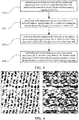
- the full borehole-covered electrical imaging logging image data can be obtained after pre-processing, static enhancement, dynamic enhancement, and full borehole image generation processing of the electrical imaging logging data. As illustrated in FIG. 3 , the process may includes:
- the static image data and the dynamic image data after the enhancement processing can be shown with reference to the images of two parts on the left in FIG. 4 .
- the static image data and the dynamic image data after the full borehole image processing can be shown with reference to the images of two parts on the right in FIG. 4 . It can thus be seen that, the blank part of the original image can be effectively removed through the full borehole image processing, so as to make image characteristic more complete and intuitive, which lays a foundation for automatic identification and extraction of the image characteristic in a later period.
- Step 23 extracting vertical denudation pore characteristic and horizontal denudation pore characteristic from electrical imaging logging image data of an undetermined reservoir and counting characteristic parameters of well logging .
- step 23 can also extract the vertical denudation pore characteristic and the horizontal denudation pore characteristic from the full borehole-covered static image data and dynamic image data through existing image processing techniques.
- a specific method for quantitatively extracting image characteristic may includes three parts: the characteristic color, the characteristic morphology and the characteristic texture. Such step is based on the electrical imaging logging image segmentation, the category to which the characteristic belong is determined after comprehensive analysis of the characteristic color, the characteristic morphology and the characteristic texture.
- the characteristic color is mainly refers to the magnitude and distribution of the grayscale value within pixel points contained in the characteristic object, and described using the maximum value of grayscale Gmax, the minimum value of grayscale Gmin, and the mean value of grayscale Gavg.
- the analysis of the characteristic morphology is mainly described in four parameters: the characteristic area A, the aspect ratio F, the roundness R, and the direction D, which can be determined in the following method.
- the direction D describes the extended orientation of the characteristic object, that is, the angle of the characteristic object between a major axis direction and a horizontal direction.
- this step proposes the use of the gray-level co-occurrence matrix method to quantitatively calculate texture characteristic parameters, such as texture second-order moment W M , contrast ratio W C , uniformity W H and the like, which can be determined in the following method:
- the numerator on the right side of the equal sign indicates the number of elements pair having the spatial relationship f (x 1 , y 1 ) and the values divided into g 1 and g 2 , while the denominator indicates the total number of elements pair in S (#S).
- the parameters of texture such as the texture second-order moment W M , the contrast ratio W C , and the uniformity W H can be calculated in formulas as follows:
- W M ⁇ g 1 ⁇ g 2 p 2 g 1 , g 2
- W C ⁇ g 1 ⁇ g 2
- W H ⁇ g 1 ⁇ g 2 p g 1 , g 2 k +
- the number N describes the development degree of characteristic, and determined by the accumulation of characteristic counts in unit depth.
- the average particle size Gs describe the average size of the characteristic which can be described by the Feret diameter.
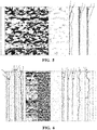
- FIG. 5 illustrates the characteristic extraction effects and the statistical results of the characteristic parameters in this step, in which the images from the first to third parts in the left represent information on depth, full borehole static image and dynamic image, respectively; the image in the fourth part is the extracted characteristic boundary of the vertical denudation pore and the horizontal denudation pore; the images in the fifth to seventh parts represent the the plane porosity, the average particle size and the number of the vertical denudation pore and the horizontal denudation pore obtained by counting, respectively.
- the curve A represents the plane porosity of the vertical denudation pore
- the curve B represents the plane porosity of the horizontal denudation pore
- the curve C represents the vertical average particle size
- the curve D represents the horizontal average particle size
- the curve E represents the number of vertical parameters
- the curve F represents the number of horizontal parameters.
- Step 24 determining karst belts of the undetermined reservoir and classifying the karst development degree according to the vertical denudation pore characteristic, the horizontal denudation pore characteristic and the characteristic parameters of well logging.
- the type to which the karst belts pertain can be discriminated according to the plane porosity of the vertical denudation pore characteristic and the horizontal denudation pore characteristic. If the plane porosityof the vertical denudation pore Ap V is greater than the plane porosity of the horizontal denudation pore Ap H , the corresponding stratum is located in the vertical percolation karsts, otherwise, located in the horizontal underwater current karsts.
- the karst development degree can be classified according to the development indexof karst of the vertical percolation karsts Kf V and the development index of the horizontal underwater current karsts Kf H which are determined by plane porosity, particle sizes, and number, and stratum porosity and karst thickness of the denudation pore in the present embodiment.
- Kf V a V ⁇ A p V ⁇ b V ⁇ G s V + c V ⁇ N V + d V ⁇ ⁇ v + e V ⁇ H V
- Kf V is the development index of the vertical percolation karsts
- Ap V is the plane porosity of the vertical denudation pore
- Gs V is the average particle size of the vertical denudation pore
- N V is the number of the vertical denudation pore
- ⁇ V is the calculated porosity of conventional well logging of the corresponding formation
- H V is the total thickness of the determined vertical percolation karsts
- a V , b V , c V , d V , e V are parameters of predetermined areas, respectively, determined according to the development strength and scale of the overall karst in the vertical percolation karsts of the undetermined reservoir.
- Kf H a H ⁇ A p H ⁇ b H ⁇ G s H + c H ⁇ N H + d H ⁇ ⁇ H + e H ⁇ H H
- Kf H is the development index of the horizontal underwater current karsts
- Ap H is the plane porosity of the horizontal denudation pore
- Gs H is the average particle size of the horizontal denudation pore
- N H is the number of the horizontal denudation pore
- ⁇ H is the calculated porosity of conventional well logging of the corresponding stratum
- H H is the total thickness of the determined horizontal underwater current karsts
- a H , b H , c H , d H , e H are parameters of predetermined areas, respectively, determined according to the development strength and scale of the overall karst of the horizontal underwater current karsts of the undetermined reservoir.
- the karst development degree can be classified.
- the greater the value of Kf V or Kf H indicating that the higher the karst development degree of strata.
- the smaller the value of Kf V or Kf H indicating that the lower the karst development degree of the strata.
- the development index of stratigraphic karst can be quantitatively divided into three levels according to the development index of the karst:
- Grade I karst vertical percolation karsts Kf V ⁇ CPv I ; horizontal underwater current karsts Kf H ⁇ CPh I .
- Grade II karst vertical percolation karsts CPv II ⁇ Kf V ⁇ CPv I ; horizontal underwater current karsts CPh II ⁇ Kf H ⁇ CPh I .
- Grade III karst vertical percolation karsts Kf V ⁇ CPv II ; horizontal underwater current karsts Kf H ⁇ CPh II .
- CPv I , CPv II , CPh I , CPh II are standards for classifying the karst development degree in Grade I and Grade II for vertical percolation karsts and horizontal underwater current karsts, respectively, and which can usually be valued at 6.5, 3.5, 6.0, 3.0 according to the actual karst development degree of the regions.
- FIG. 6 illustrates karst belts and the karst development degree classified by characteristic parameters of the karst.
- the curve a in the first part of the image from the left represents the conventional natural gamma ray (GR)
- the curve b represents the photoelectric absorption eoss-section index (PE)
- the curve c represents the caliper (CAL).
- the curve d in the second part of the image represents the density (DEN)
- the curve e represents neutron (CNL)
- the curve f represents the sound wave (AC).
- the curve g in the third part of the image represents deep lateral resistivity (RD)
- the curve h represents shallow lateral resistivity (RS).
- the fourth part is depth.
- the fifth to seventh parts of the image represent information on full borehole static image and dynamic images, and the extracted characteristic boundary of the vertical denudation pore and the horizontal denudation pore.
- the curve i represents the plane porosity of the vertical denudation pore characteristic
- the curve j represents the plane porosity of the horizontal denudation pore characteristic.
- the curve k represents the particle size of the vertical denudation pore characteristic
- the curve m represents the particle size of the horizontal denudation pore characteristic.
- the curve n represents the number parameter of the vertical denudation pore characteristic
- the curve o represents the number parameter of the horizontal denudation pore characteristic.
- the curve p represents the porosity.
- the twelfth part of the image it is the result of identifying karst belts, which consists of three parts: the uppermost part being the top of the karst, the intermediate part being vertical percolation karsts and the lowermost part being horizontal underwater current karsts.
- the thirteenth part of the image is the calculated development index of the karst, wherein the curve q represents the development index of the vertical percolation karsts and the curve r represents the development index of the horizontal underwater current karsts.
- the fourteenth part of the image represents the karst development degree classified according to the development index of the karst.
- the uppermost part is the karst in Grade I
- the intermediate part is the karst in Grade II
- the lowermost part is the karst in Grade III.
- the fifteenth part of the image represents the interpretation result of the effective reservoir, wherein the karst in Grades I and II can meet the requirements of industrial capacity.
- the upper part of the well is mainly characterized by vertical denudation pores, which are divided into vertical percolation karsts; and the lower part is horizontal underwater current karsts.
- the karst development index calculated by combining the conventional porosity and the developmental thickness of the identified karst belts indicates that, the higher overall development degree of the vertical percolation karsts, the development index of the karst is essentially above 6.5, which can be classified into development of the karst in Grade I.
- the horizontal underwater current karsts the plane porosity of the pores and particle sizes decreases from the upper part to the lower part, and the degree of karstification gradually decreases.
- the development index of the upper karst is distributed between 6 and 8, which can be classified into the karst in Grade I.
- the development index of the lower karst is mainly distributed between 4 and 6, which can be classified into the karst in Grade II.
- Step 25 determining the effective reservoir development degree of the undetermined reservoir according to the karst belts and the result of the classified karst development degree.
- the well section (3954.0-3965.0m) as shown in FIG 6 is located at the upper part of the vertical percolation karsts and the horizontal underwater current karsts, which pertains to a favorable reservoir development position as a whole. And meanwhile, the greater karst development index calculated in this section indicates the high karst development degree, the karst development degree is in Grade I, which is comprehensively assessed as industrial gas section.
- This embodiment was applied on-site in well A of a certain oil-gas field. We can quickly and visually identify karst belts in a reservoir and classify the karst development degree. The discrimination result is consistent with that of cores, which provides important technical supports for exploration and development of an oil-gas field.
- the method for determining the karst development degree of the reservoir proposed in this embodiment has the following advantages.
- a quantitative calculation method of the karst development index was established by characterizing parameters of denudation pore, such as plane porosity, particle sizes, and number, and stratum porosity and karst thickness, and the corresponding relationship between this index and the karst development degree was established, which solved the uncertainty in the evaluation of the karst development degree of the the reservoir.
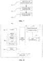
- This embodiment provides a device for determining the karst development degree of a reservoir. As illustrated in FIG. 7 , the device includes:
- a characteristic and parameter extraction unit 71 configured to extract vertical denudation pore characteristic and horizontal denudation pore characteristic from electrical imaging logging image data of an undetermined reservoir and count characteristic parameters of well logging;
- a development degree classification unit 72 configured to determine karst belts of the undetermined reservoir and classify the karst development degree according to the vertical denudation pore characteristic, the horizontal denudation pore characteristic and the characteristic parameters of well logging .
- a development degree determination unit 73 configured to determine the effective reservoir development degree of the undetermined reservoir according to the karst belts and the result of the classified karst development degree.
- the characteristic and parameter extraction unit 71 can obtain the electrical imaging logging image data of the undetermined reservoir through the existing electrical imaging logging method and obtain the static images and dynamic images after processing the electrical imaging logging image data by the predetermined image processing method, and then, obtain the vertical denudation pore characteristic and the horizontal denudation pore characteristic of electrical imaging logging image data by quantitatively extracting the static images and dynamic images.
- the development degree classification unit 72 can determine the karst belts of the undetermined reservoir according to the vertical denudation pore characteristic and the horizontal denudation pore characteristic. If the plane porosityof the vertical denudation pore Ap V is greater than the plane porosity of the horizontal denudation pore Ap H , the corresponding undetermined reservoir can be determined to be located in vertical percolation karsts,, otherwise it is located in horizontal underwater current karsts. According to the determined development index of the vertical vertical percolation karsts Kf V and the development index of the horizontal underwater current karsts Kf H , the karst development degree can be directly classified. The greater the value of Kf V or Kf H , indicating the higher the karst development degree of the strata. And the smaller the value of Kf V or Kf H . indicating the lower the karst development degree of the strata.
- the development degree determination unit 73 can determine the development condition of the effective reservoir according to the karst belts and the result of the classified karst development degree.
- the correspondence between different karst belts and the effective reservoir is that, good reservoirs are developed in the vertical percolation karsts, and normal reservoirs or poor reservoirs are developed in the horizontal underwater current karsts.
- the karst development degree reaches a better or best level, the corresponding reservoir is a good one, of which the reservoir productivity can reach industrial capacity.
- the karst development degree is of poor level, the reservoir is poor and cannot meet requirements of the industrial capacity.
- the karst belts of the reservoirs can be identified quickly and visibly, and the karst development degree can be classified.
- the discrimination result is consistent with that of cores, which provides important technical supports for exploration and development of an oil-gas field.
- This embodiment of the present invention provides an electronic device including the device for determining the karst development degree of the reservoir as claimed in the Embodiment 2.
- FIG. 8 is a schematic block diagram of the system comprised of the electronic device in the Embodiment of the present invention.
- the electronic device 800 may includes a central processing unit 100 and a memory 140.
- the memory 140 is coupled to the central processing unit 100.
- FIG. 8 is exemplary. Other types of structures may also be used to supplement or replace the structure to effect telecommunication or other functions.
- functions of a device that determines the karst development degree of reservoirs may be integrated into the central processing unit 100.
- the CPU 100 can be configured to perform the following operation: extract vertical denudation pore characteristic and horizontal denudation pore characteristic from electrical imaging logging image data of an undetermined reservoir and count well logging; determine karst belts of the undetermined reservoir and classify the karst development degree according to the vertical denudation pore characteristic, the horizontal denudation pore characteristic and the characteristic parameters of well logging; and determine the effective reservoir development degree of the undetermined reservoir according to the karst belts and the result of the classified karst development degree.
- the device for determining the karst development degree of reservoirs may be configured separately from the CPU 100.
- the device for determining the karst development degree of reservoirs may be configured as a chip connected to the CPU 100 and achieve functions of the device that determines the karst development degree of reservoirs by control of the central processing unit.
- the electronic device 800 may further includes: a communication module 110, an input unit 120, an audio processing unit 130, a display 160, and a power supply 170. It should be noted that the electronic device 800 does not necessarily include all the components illustrated in FIG. 8 . In addition, the electronic device 800 may further includes components that not illustrated in FIG. 8 , and reference may be made to the prior art.
- the central processor 100 is also referred to as a controller or operational control. It may include a microprocessor or other processor device and/or logic device. And the central processor 100 receives inputs and controls the operations of each component of the electronic device 800.
- the memory 140 may be one or more of a buffer, a flash memory, a hard drive, a removable medium, a volatile memory, a non-volatile memory or other suitable device.
- the aforementioned failure-related information can be stored, in addition, the program for executing the relevant information may also be stored.
- the CPU 100 may execute the program stored in the memory 140 to implement information storage or processing and the like. Functions of other components are similar to those in the prior art and details are not described herein again.
- the components of the electronic device 800 may be implemented by dedicated hardware, firmware, software or a combination thereof without departing from the scope of the present invention.
- Embodiments of the present invention further provide a computer readable program, wherein when the program is executed in an electronic device, the program allows the computer to perform the method for determining the karst development degree of reservoirs in the electronic device according to the Embodiment 1.
- Embodiments of the present invention further provide a storage medium storing a computer-readable program, wherein the computer-readable program allows the computer to perform the method for determining the karst development degree of reservoirs in the electronic device according to the Embodiment 1.
Landscapes
- Engineering & Computer Science (AREA)
- Physics & Mathematics (AREA)
- Life Sciences & Earth Sciences (AREA)
- General Physics & Mathematics (AREA)
- Geology (AREA)
- General Life Sciences & Earth Sciences (AREA)
- Mining & Mineral Resources (AREA)
- Theoretical Computer Science (AREA)
- Geophysics (AREA)
- Environmental & Geological Engineering (AREA)
- Computer Vision & Pattern Recognition (AREA)
- Fluid Mechanics (AREA)
- Geochemistry & Mineralogy (AREA)
- Remote Sensing (AREA)
- Quality & Reliability (AREA)
- General Health & Medical Sciences (AREA)
- Biomedical Technology (AREA)
- Health & Medical Sciences (AREA)
- Multimedia (AREA)
- Molecular Biology (AREA)
- Data Mining & Analysis (AREA)
- Acoustics & Sound (AREA)
- Artificial Intelligence (AREA)
- Evolutionary Biology (AREA)
- Bioinformatics & Computational Biology (AREA)
- Bioinformatics & Cheminformatics (AREA)
- General Engineering & Computer Science (AREA)
- Evolutionary Computation (AREA)
- Geophysics And Detection Of Objects (AREA)
Abstract
Description
- The present invention relates to a method and device for determining the karst development degree of a reservoir, and pertains to the technical field of well logging interpretation.
- Weathered crust karst-type oil-gas reservoirs are one of important types of carbonate oil-gas resources. A large number of studies have shown that a key factor of controlling development and distribution of weathered crust karst-type reservoirs lies in a development degree of karstification. Forming erosion fractured cavities by modification of the original formation by means of karstification, which has a significant impact on reservoir properties of reservoirs and enhancement of seepage capability. Therefore, how to accurately identify weathered crust karst-type reservoirs and classify the development degree of karstification by using the existing logging methods can provide important technical basis for distinguishing reservoir validity, increasing oil and gas reserves and developing measures for oil and gas wells.
- An evaluation of a karst development degree in the prior art is mainly based on observation and description of cores, where a qualitative classification of dissolved apertures on the surface of rocks and developments of fractures is performed by coring the reservoirs or sampling and observing outcrop rock drilling. Such methods are highly dependent upon cores with high cost and poor operability. In addition, since the cores acquired in the oil field are always discontinuous, and a complete coring is very difficult at the fracture development interval, it is difficult for the karst development characteristic observed on the cores to represent overall conditions of reservoirs, thereby affecting a comprehensive discrimination of the reservoirs.
- Although imaging logging in conjunction with conventional logging techniques have been used in the prior art to classify weathered crust karst-type reservoirs into karst zones, such as a supergenic karst zone, a vertical vadose zone, a horizontal hyporheic zone and the like longitudinally, and identify the karst zones according to imaging logging characteristic pattern plates and logging response characteristic modes of different karst zones qualitatively. However, the development degree of specific karstification of the karst zones is not classified or evaluated, thus an application of processing interpretation of the imaging logging data essentially remains in the qualitative analysis stage, it cannot meet requirements of logging evaluation of the weathered crust karst-type reservoirs.
- In order to solve the problems that the existing method of classification of karst development degree has strong multiplicity and poor operability, and cannot meet the requirements of well logging evaluation of weathered crust karst-type reservoirs, a method and a device for determining the karst development degree of a reservoir is proposed, concretely including the following technical solutions.
- A method for determining the karst development degree of a reservoir includes:
- extracting vertical denudation pore characteristic and horizontal denudation pore characteristic from electrical imaging logging image data of an undetermined reservoir and counting characteristic parameters of well logging;
- determining karst belts of the undetermined reservoir and classifying the karst development degree according to the vertical denudation pore characteristic, the horizontal denudation pore characteristic and the characteristic parameters of well logging; and
- determining the effective reservoir development degree of the undetermined reservoir according to the karst belts and the result of the classified karst development degree.
- A device for determining the karst development degree of a reservoir includes:
- a characteristic and parameter extraction unit, configured to extract vertical denudation pore characteristic and horizontal denudation pore characteristic from electrical imaging logging image data of an undetermined reservoir and count characteristic parameters of well logging;
- a development degree classification unit, configured to determine karst belts of the undetermined reservoir and classify the karst development degree according to the vertical denudation pore characteristic, the horizontal denudation pore characteristic and the characteristic parameters of well logging; and
- a development degree determination unit, configured to determine the effective reservoir development degree of the undetermined reservoir according to the karst belts and the result of the classified karst development degree.
- The advantages of the present invention are as follows: by means of classifying the karst development degree of the undetermined reservoir based on the vertical denudation pore characteristic, the horizontal denudation pore characteristic and the characteristic parameters of well logging extracted from the electrical imaging logging image data, we can quickly and visually identify karst belts in a reservoir and classify the karst development degree. And the discrimination result is consistent with that of cores, which provides important technical supports for exploration and development of an oil-gas field.
-
-
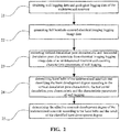
FIG. 1 is a flowchart illustrating a method for determining the karst development degree of a reservoir by way of example. -
FIG. 2 is a flowchart of the method for determining the karst development degree of the reservoir proposed in Embodiment 1. -
FIG. 3 is a flowchart of generating full borehole-covered electrical imaging logging image data proposed in the Embodiment 1. -
FIG. 4 is a schematic diagram of static and dynamic full borehole image information obtained by processing the electrical imaging logging data proposed in the Embodiment 1. -
FIG. 5 is a schematic diagram of boundaries of vertical denudation pore, horizontal denudation pore and characteristic parameters extracted by the electrical imaging logging image proposed in the Embodiment 1. -
FIG. 6 is a schematic diagram of the classification results of the karst belts and the karst development degree proposed in the Embodiment 1. -
FIG. 7 is a structural diagram of a device for determining the karst development degree of the reservoir proposed in the Embodiment 2. -
FIG. 8 is a structural diagram of the electronic device proposed in the Embodiment 3. - Since the existing methods cannot classify the development degree of specific karstification of karst belts in weathered crust karst-type reservoirs in the prior art, it is impossible to determine an overall condition of reservoirs that affects the logging evaluation results of such reservoirs. However, the inventor of the present invention found in studies of the weathered crust karst-type reservoirs that: the vertical percolation karsts had karstifications dominated by vertical denudation and developed vertical denudation pores; the horizontal underwater current karsts had karstifications dominated by horizontal denudation and developed layered-denudation pores; and the development degree of denudation pores reflects the level of karstification in stratum. Therefore, the development degree of karstification of reservoirs can be classified by identifying and extracting the denudation pore characteristic in the vertical percolation karsts and the horizontal underwater current karsts on the electrical imaging logging images.
- As illustrated in
FIG. 1 , the method for determining the karst development degree of the reservoir proposed in this embodiment includes: -
Step 11, extracting vertical denudation pore characteristic and horizontal denudation pore characteristic from electrical imaging logging image data of an undetermined reservoir and counting characteristic parameters of well logging. - The electrical imaging logging image data of the undetermined reservoir can be obtained from measurements of the existing electrical imaging logging instruments, and the static images and dynamic images can be obtained after processing the electrical imaging logging data by the predetermined processing method. The static images and dynamic images can be processed by the predetermined probabilistic interpolation processing method to obtain full borehole-covered electrical imaging logging image data.
- By means of image analysis, the vertical denudation pore characteristic and the horizontal denudation pore characteristic are quantitatively extracted from the electrical imaging logging image data of the undetermined reservoir, and characteristic parameters of the vertical denudation pore and the horizontal denudation pore are counted in the unit depth range.
- In practice, in order to obtain more characteristic and characteristic parameters of well logging, the vertical denudation pore characteristic and the horizontal denudation pore characteristic can also be extracted from the full borehole-covered electrical imaging logging image data and the characteristic parameters of well logging can be counted.
- Alternatively, processes of obtaining the vertical denudation pore characteristic and the horizontal denudation pore characteristic include three parts: the characteristic color, the characteristic morphology and the characteristic texture. This embodiment determines the category of the characteristic by comprehensively analyzing the characteristic color, the characteristic morphology and the characteristic texture on the basis of the electrical imaging logging image.
- Alternatively, the characteristic parameters of the vertical denudation pore and the horizontal denudation pore include: plane porosity, average particle size and number of the pores. This embodiment counts the plane porosity, average particle size and number of the vertical denudation pore and the horizontal denudation pore in the unit depth range on the basis of extraction of the image characteristic.
- Step 12: determining karst belts of the undetermined reservoir and classifying the karst development degree according to the vertical denudation pore characteristic, the horizontal denudation pore characteristic and the characteristic parameters of well logging.
- The karst belts of the undetermined reservoir pertains can be discriminated according to the vertical denudation pore characteristic and the horizontal denudation pore characteristic. If the plane porosity of the vertical denudation pore ApV is greater than the plane porosity of the horizontal denudation pore ApH , the corresponding undetermined reservoir can be determined to be located in vertical percolation karsts, otherwise it is located in horizontal underwater current karsts.
- Alternatively, the development index of the vertical percolation karsts KfV and the development index of the horizontal underwater current karsts KfH can be determined by plane porosity, particle sizes, and number of the denudation pore, and stratum porosity and karst thickness in the characteristic parameters of well logging.
- According to the determined development index of the vertical percolation karsts KfV and the determined development index of the horizontal underwater current karsts KfH , the karst development degree can be directly classified. The greater the value of KfV or KfH , indicating that the higher the karst development degree of the strata. And the smaller the value of KfV or KfH , indicating that the lower the karst development degree of the strata.
-
Step 13, determining the effective reservoir development degree of the undetermined reservoir according to the karst belts and the result of the classified karst development degree. - According to the karst belts and the result of the classified karst development degree, the development condition of the effective reservoir is determined. The correspondence between different karst belts and the effective reservoir is that, good reservoirs are developed in the vertical percolation karsts, and normal reservoirs or poor reservoirs are developed in the horizontal underwater current karsts. On the basis of the favorable karst belts where the reservoirs are located, if the karst development degree reaches a better or best level, the corresponding reservoir is a good one, of which the reservoir productivity can reach industrial capacity. And if the karst development degree is of poor level, the reservoir is poor and cannot meet requirements of the industrial capacity.
- According to the technical solution proposed in this embodiment, by means of classifying the karst development degree of the undetermined reservoir based on the vertical denudation pore characteristic, the horizontal denudation pore characteristic and the characteristic parameters of well logging extracted from the electrical imaging logging image data, the karst belts of the reservoir can be identified quickly and visibly, and the karst development degree can be classified. The discrimination result is consistent with that of cores, which provides important technical supports for exploration and development of an oil-gas field.
- The technical solutions proposed in the present invention are described in detail below through embodiments.
- As illustrated in
FIG. 2 , the method for determining the karst development degree of the reservoir proposed in this embodiment includes:
Step 21, obtaining well logging data and geological logging data of the undetermined reservoir. - The well logging data of the undetermined reservoir mainly includes the electrical imaging logging data of the objective intervals in the research area and also other conventional well logging data, geological data, logging data and relevant data of description and analysis of cores, for purposes of comprehensive discrimination of development position of the karst and stratigraphic position.
- Step 22: generating full borehole-covered electrical imaging logging image data.
- The full borehole-covered electrical imaging logging image data can be obtained after pre-processing, static enhancement, dynamic enhancement, and full borehole image generation processing of the electrical imaging logging data. As illustrated in
FIG. 3 , the process may includes: - Step 221: performing acceleration correction and the equalization processing on the electrical imaging logging data of the undetermined reservoir to obtain original electrical imaging logging image data.
- Step 222: performing static enhancement processing on the original electrical imaging logging image data to obtain static image data which reflects color changes of the rock in the whole well.
- Step 223: performing dynamic enhancement processing on the original electrical imaging logging image data to obtain dynamic image data which reflects color changes of the rock in the whole well.
-
Step 224, performing probabilistic interpolation processing on the uncovered parts in the static image data and the dynamic image data using the full borehole image processing method to obtain the full borehole-covered electrical imaging logging image data. - In this step, taking well A in an oil-gas field as an example. The static image data and the dynamic image data after the enhancement processing can be shown with reference to the images of two parts on the left in
FIG. 4 . The static image data and the dynamic image data after the full borehole image processing can be shown with reference to the images of two parts on the right inFIG. 4 . It can thus be seen that, the blank part of the original image can be effectively removed through the full borehole image processing, so as to make image characteristic more complete and intuitive, which lays a foundation for automatic identification and extraction of the image characteristic in a later period. -
Step 23, extracting vertical denudation pore characteristic and horizontal denudation pore characteristic from electrical imaging logging image data of an undetermined reservoir and counting characteristic parameters of well logging . - In practice, step 23 can also extract the vertical denudation pore characteristic and the horizontal denudation pore characteristic from the full borehole-covered static image data and dynamic image data through existing image processing techniques. A specific method for quantitatively extracting image characteristic may includes three parts: the characteristic color, the characteristic morphology and the characteristic texture. Such step is based on the electrical imaging logging image segmentation, the category to which the characteristic belong is determined after comprehensive analysis of the characteristic color, the characteristic morphology and the characteristic texture.
- Alternatively, the characteristic color is mainly refers to the magnitude and distribution of the grayscale value within pixel points contained in the characteristic object, and described using the maximum value of grayscale Gmax, the minimum value of grayscale Gmin, and the mean value of grayscale Gavg.
- Alternatively, the analysis of the characteristic morphology is mainly described in four parameters: the characteristic area A, the aspect ratio F, the roundness R, and the direction D, which can be determined in the following method.
- Setting the single pixel point area of the imaging logging image as a unit area and the characteristic area A as an actual pixel point number that the characteristic object contains.
- The aspect ratio F describes the slender degree of the characteristic object, F = W/L, where L is length of the object's minimum bounding rectangle and W is width of the object's minimum bounding rectangle.
- The roundness R describes the rounding degree of the characteristic object, R = P2/A, where P is the circumference of the object, calculated based on the object's boundary points, and A is the characteristic area.
- The direction D describes the extended orientation of the characteristic object, that is, the angle of the characteristic object between a major axis direction and a horizontal direction.
- Alternatively, for characteristic texture analysis, this step proposes the use of the gray-level co-occurrence matrix method to quantitatively calculate texture characteristic parameters, such as texture second-order moment WM, contrast ratio WC, uniformity WH and the like, which can be determined in the following method:
- For an image S, if a function f(x1, y1) defines the spatial relationship between two parameters, elements in S's grayscale co-occurrence matrix p are defined as:

- In formula (1), the numerator on the right side of the equal sign indicates the number of elements pair having the spatial relationship f(x1, y1) and the values divided into g1 and g2, while the denominator indicates the total number of elements pair in S (#S).
- The parameters of texture, such as the texture second-order moment WM, the contrast ratio WC, and the uniformity WH can be calculated in formulas as follows:


- According to the vertical denudation pore characteristic and the horizontal denudation pore characteristic obtained by extraction, counting the plane porosity Ap, average particle size Gs and number N of the denudation pores in the unit depth range.
- The number N describes the development degree of characteristic, and determined by the accumulation of characteristic counts in unit depth.
- the plane porosity Ap describes strength of the characteristic development and

- The average particle size Gs describe the average size of the characteristic which can be described by the Feret diameter. A single characteristic particle size Gsi can be averaged by measuring diameters of the characteristic object in multiple directions, and the average particle size in the unit depth range can be determined as:

-
FIG. 5 illustrates the characteristic extraction effects and the statistical results of the characteristic parameters in this step, in which the images from the first to third parts in the left represent information on depth, full borehole static image and dynamic image, respectively; the image in the fourth part is the extracted characteristic boundary of the vertical denudation pore and the horizontal denudation pore; the images in the fifth to seventh parts represent the the plane porosity, the average particle size and the number of the vertical denudation pore and the horizontal denudation pore obtained by counting, respectively. Wherein, the curve A represents the plane porosity of the vertical denudation pore, the curve B represents the plane porosity of the horizontal denudation pore, the curve C represents the vertical average particle size, the curve D represents the horizontal average particle size, the curve E represents the number of vertical parameters, and the curve F represents the number of horizontal parameters. - Step 24: determining karst belts of the undetermined reservoir and classifying the karst development degree according to the vertical denudation pore characteristic, the horizontal denudation pore characteristic and the characteristic parameters of well logging.
- The type to which the karst belts pertain can be discriminated according to the plane porosity of the vertical denudation pore characteristic and the horizontal denudation pore characteristic. If the plane porosityof the vertical denudation pore ApV is greater than the plane porosity of the horizontal denudation pore ApH , the corresponding stratum is located in the vertical percolation karsts, otherwise, located in the horizontal underwater current karsts.
- Alternatively, the karst development degree can be classified according to the development indexof karst of the vertical percolation karsts KfV and the development index of the horizontal underwater current karsts KfH which are determined by plane porosity, particle sizes, and number, and stratum porosity and karst thickness of the denudation pore in the present embodiment.
- The development index of the vertical percolation karsts KfV can be determined in the following formula:

- where KfV is the development index of the vertical percolation karsts; ApV is the plane porosity of the vertical denudation pore; GsV is the average particle size of the vertical denudation pore; NV is the number of the vertical denudation pore; ∅ V is the calculated porosity of conventional well logging of the corresponding formation; HV is the total thickness of the determined vertical percolation karsts; and aV , bV, cV , dV, eV are parameters of predetermined areas, respectively, determined according to the development strength and scale of the overall karst in the vertical percolation karsts of the undetermined reservoir.
- The development index of the horizontal underwater current karsts KfH can be determined in the following formula:

- where KfH is the development index of the horizontal underwater current karsts; ApH is the plane porosity of the horizontal denudation pore; GsH is the average particle size of the horizontal denudation pore; NH is the number of the horizontal denudation pore; ∅ H is the calculated porosity of conventional well logging of the corresponding stratum; HH is the total thickness of the determined horizontal underwater current karsts; and aH , bH , cH, dH , eH are parameters of predetermined areas, respectively, determined according to the development strength and scale of the overall karst of the horizontal underwater current karsts of the undetermined reservoir.
- According to the determined development index of the vertical percolation karsts KfV and the development index of the horizontal underwater current karsts KfH , the karst development degree can be classified. The greater the value of KfV or KfH , indicating that the higher the karst development degree of strata. And the smaller the value of KfV or KfH, indicating that the lower the karst development degree of the strata. Alternatively, the development index of stratigraphic karst can be quantitatively divided into three levels according to the development index of the karst:
- Grade I karst: vertical percolation karsts KfV ≥ CPvI; horizontal underwater current karsts KfH ≥ CPhI.
- Grade II karst: vertical percolation karsts CPvII ≤ KfV < CPvI ; horizontal underwater current karsts CPhII ≤ KfH < CPhI.
- Grade III karst: vertical percolation karsts KfV < CPvII ; horizontal underwater current karsts KfH < CPhII.
- Wherein, CPvI , CPvII , CPhI , CPhII are standards for classifying the karst development degree in Grade I and Grade II for vertical percolation karsts and horizontal underwater current karsts, respectively, and which can usually be valued at 6.5, 3.5, 6.0, 3.0 according to the actual karst development degree of the regions.
- For instance,
FIG. 6 illustrates karst belts and the karst development degree classified by characteristic parameters of the karst. Wherein the curve a in the first part of the image from the left represents the conventional natural gamma ray (GR), the curve b represents the photoelectric absorption eoss-section index (PE), the curve c represents the caliper (CAL). The curve d in the second part of the image represents the density (DEN), the curve e represents neutron (CNL), the curve f represents the sound wave (AC). The curve g in the third part of the image represents deep lateral resistivity (RD), the curve h represents shallow lateral resistivity (RS). The fourth part is depth. The fifth to seventh parts of the image represent information on full borehole static image and dynamic images, and the extracted characteristic boundary of the vertical denudation pore and the horizontal denudation pore. In the eighth part of the image, the curve i represents the plane porosity of the vertical denudation pore characteristic, the curve j represents the plane porosity of the horizontal denudation pore characteristic. In the ninth part of the image, the curve k represents the particle size of the vertical denudation pore characteristic, the curve m represents the particle size of the horizontal denudation pore characteristic. In the tenth part of the image, the curve n represents the number parameter of the vertical denudation pore characteristic, the curve o represents the number parameter of the horizontal denudation pore characteristic. In the eleventh part of the image, the curve p represents the porosity. In the twelfth part of the image, it is the result of identifying karst belts, which consists of three parts: the uppermost part being the top of the karst, the intermediate part being vertical percolation karsts and the lowermost part being horizontal underwater current karsts. The thirteenth part of the image is the calculated development index of the karst, wherein the curve q represents the development index of the vertical percolation karsts and the curve r represents the development index of the horizontal underwater current karsts. The fourteenth part of the image represents the karst development degree classified according to the development index of the karst. The uppermost part is the karst in Grade I, the intermediate part is the karst in Grade II and the lowermost part is the karst in Grade III. The fifteenth part of the image represents the interpretation result of the effective reservoir, wherein the karst in Grades I and II can meet the requirements of industrial capacity. - As can be seen from
FIG 6 , the upper part of the well is mainly characterized by vertical denudation pores, which are divided into vertical percolation karsts; and the lower part is horizontal underwater current karsts. The karst development index calculated by combining the conventional porosity and the developmental thickness of the identified karst belts indicates that, the higher overall development degree of the vertical percolation karsts, the development index of the karst is essentially above 6.5, which can be classified into development of the karst in Grade I. In the horizontal underwater current karsts, the plane porosity of the pores and particle sizes decreases from the upper part to the lower part, and the degree of karstification gradually decreases. The development index of the upper karst is distributed between 6 and 8, which can be classified into the karst in Grade I. The development index of the lower karst is mainly distributed between 4 and 6, which can be classified into the karst in Grade II. - Step 25: determining the effective reservoir development degree of the undetermined reservoir according to the karst belts and the result of the classified karst development degree.
- Determining the development condition of the effective reservoir according to the karst belts and the result of the classified karst development degree. The well section (3954.0-3965.0m) as shown in
FIG 6 is located at the upper part of the vertical percolation karsts and the horizontal underwater current karsts, which pertains to a favorable reservoir development position as a whole. And meanwhile, the greater karst development index calculated in this section indicates the high karst development degree, the karst development degree is in Grade I, which is comprehensively assessed as industrial gas section. - This embodiment was applied on-site in well A of a certain oil-gas field. We can quickly and visually identify karst belts in a reservoir and classify the karst development degree. The discrimination result is consistent with that of cores, which provides important technical supports for exploration and development of an oil-gas field.
- The method for determining the karst development degree of the reservoir proposed in this embodiment has the following advantages.
- 1) A classification method of development degree of karstification of weathered crust karst-type reservoirs extracted based on electrical imaging logging images characteristic was proposed and implemented. Karst characteristic were extracted directly from the electrical imaging logging images and its characteristic parameters were quantitatively calculated for classification of karst development degree, which avoids multi-solution problems caused by description of the electrical imaging logging.
- 2) A quantitative calculation method of the karst development index was established by characterizing parameters of denudation pore, such as plane porosity, particle sizes, and number, and stratum porosity and karst thickness, and the corresponding relationship between this index and the karst development degree was established, which solved the uncertainty in the evaluation of the karst development degree of the the reservoir.
- 3) It was proposed that the karst development degree of the reservoir could be divided into three grades, which is of great significance to quality evaluation of the well logging reservoirs. It has significant effects in field application of scheduled oil-gas fields.
- This embodiment provides a device for determining the karst development degree of a reservoir. As illustrated in
FIG. 7 , the device includes: - A characteristic and
parameter extraction unit 71, configured to extract vertical denudation pore characteristic and horizontal denudation pore characteristic from electrical imaging logging image data of an undetermined reservoir and count characteristic parameters of well logging; - A development
degree classification unit 72, configured to determine karst belts of the undetermined reservoir and classify the karst development degree according to the vertical denudation pore characteristic, the horizontal denudation pore characteristic and the characteristic parameters of well logging . - A development
degree determination unit 73, configured to determine the effective reservoir development degree of the undetermined reservoir according to the karst belts and the result of the classified karst development degree. - The characteristic and
parameter extraction unit 71 can obtain the electrical imaging logging image data of the undetermined reservoir through the existing electrical imaging logging method and obtain the static images and dynamic images after processing the electrical imaging logging image data by the predetermined image processing method, and then, obtain the vertical denudation pore characteristic and the horizontal denudation pore characteristic of electrical imaging logging image data by quantitatively extracting the static images and dynamic images. - The development
degree classification unit 72 can determine the karst belts of the undetermined reservoir according to the vertical denudation pore characteristic and the horizontal denudation pore characteristic. If the plane porosityof the vertical denudation pore ApV is greater than the plane porosity of the horizontal denudation pore ApH , the corresponding undetermined reservoir can be determined to be located in vertical percolation karsts,, otherwise it is located in horizontal underwater current karsts. According to the determined development index of the vertical vertical percolation karsts KfV and the development index of the horizontal underwater current karsts KfH , the karst development degree can be directly classified. The greater the value of KfV or KfH, indicating the higher the karst development degree of the strata. And the smaller the value of KfV or KfH. indicating the lower the karst development degree of the strata. - The development
degree determination unit 73 can determine the development condition of the effective reservoir according to the karst belts and the result of the classified karst development degree. The correspondence between different karst belts and the effective reservoir is that, good reservoirs are developed in the vertical percolation karsts, and normal reservoirs or poor reservoirs are developed in the horizontal underwater current karsts. On the basis of the favorable karst belts where the reservoirs are located, if the karst development degree reaches a better or best level, the corresponding reservoir is a good one, of which the reservoir productivity can reach industrial capacity. And if the karst development degree is of poor level, the reservoir is poor and cannot meet requirements of the industrial capacity. - According to the technical solution proposed in this embodiment, by means of classifying the karst development degree of the undetermined reservoir based on the vertical denudation pore characteristic, the horizontal denudation pore characteristic and the characteristic parameters of well logging extracted from electrical imaging logging image data, the karst belts of the reservoirs can be identified quickly and visibly, and the karst development degree can be classified. The discrimination result is consistent with that of cores, which provides important technical supports for exploration and development of an oil-gas field.
- This embodiment of the present invention provides an electronic device including the device for determining the karst development degree of the reservoir as claimed in the Embodiment 2.
-
FIG. 8 is a schematic block diagram of the system comprised of the electronic device in the Embodiment of the present invention. As illustrated inFIG. 8 , theelectronic device 800 may includes acentral processing unit 100 and amemory 140. Thememory 140 is coupled to thecentral processing unit 100. It should be noted that,FIG. 8 is exemplary. Other types of structures may also be used to supplement or replace the structure to effect telecommunication or other functions. - In one embodiment, functions of a device that determines the karst development degree of reservoirs may be integrated into the
central processing unit 100. TheCPU 100 can be configured to perform the following operation: extract vertical denudation pore characteristic and horizontal denudation pore characteristic from electrical imaging logging image data of an undetermined reservoir and count well logging; determine karst belts of the undetermined reservoir and classify the karst development degree according to the vertical denudation pore characteristic, the horizontal denudation pore characteristic and the characteristic parameters of well logging; and determine the effective reservoir development degree of the undetermined reservoir according to the karst belts and the result of the classified karst development degree. - In another embodiment, the device for determining the karst development degree of reservoirs may be configured separately from the
CPU 100. For example, the device for determining the karst development degree of reservoirs may be configured as a chip connected to theCPU 100 and achieve functions of the device that determines the karst development degree of reservoirs by control of the central processing unit. - As illustrated in
FIG. 8 , theelectronic device 800 may further includes: acommunication module 110, aninput unit 120, anaudio processing unit 130, adisplay 160, and apower supply 170. It should be noted that theelectronic device 800 does not necessarily include all the components illustrated inFIG. 8 . In addition, theelectronic device 800 may further includes components that not illustrated inFIG. 8 , and reference may be made to the prior art. - As illustrated in
FIG. 8 , thecentral processor 100 is also referred to as a controller or operational control. It may include a microprocessor or other processor device and/or logic device. And thecentral processor 100 receives inputs and controls the operations of each component of theelectronic device 800. - The
memory 140, for example, may be one or more of a buffer, a flash memory, a hard drive, a removable medium, a volatile memory, a non-volatile memory or other suitable device. The aforementioned failure-related information can be stored, in addition, the program for executing the relevant information may also be stored. And theCPU 100 may execute the program stored in thememory 140 to implement information storage or processing and the like. Functions of other components are similar to those in the prior art and details are not described herein again. The components of theelectronic device 800 may be implemented by dedicated hardware, firmware, software or a combination thereof without departing from the scope of the present invention. - Embodiments of the present invention further provide a computer readable program, wherein when the program is executed in an electronic device, the program allows the computer to perform the method for determining the karst development degree of reservoirs in the electronic device according to the Embodiment 1.
- Embodiments of the present invention further provide a storage medium storing a computer-readable program, wherein the computer-readable program allows the computer to perform the method for determining the karst development degree of reservoirs in the electronic device according to the Embodiment 1.
- The technical solutions of the present invention are clearly and completely described in the Embodiments, where the Embodiments are merely some but not all of the Embodiments of the present invention. All other Embodiments obtained by those skilled in the art based on the Embodiments of the present invention without creative efforts shall fall within the protection scope of the present invention
Claims (11)
- A method for determining the karst development degree of a reservoir comprising:extracting vertical denudation pore characteristic and horizontal denudation pore characteristic from electrical imaging logging image data of an undetermined reservoir and counting characteristic parameters of well logging;determining karst belts of the undetermined reservoir and classifying the karst development degree according to the vertical denudation pore characteristic, the horizontal denudation pore characteristic and the characteristic parameters of well logging; anddetermining the effective reservoir development degree of the undetermined reservoir according to the karst belts and the result of the classified karst development degree.
- The method according to Claim 1, wherein extracting vertical denudation pore characteristic and horizontal denudation pore characteristic from electrical imaging logging image data of an undetermined reservoir and counting characteristic parameters of well logging further comprising:obtaining full borehole-covered electrical imaging logging image data according to the electrical imaging logging image data of the undetermined reservoir; andextracting the vertical denudation pore characteristic and the horizontal denudation pore characteristic from the full borehole-covered electrical imaging logging image data, and counting the characteristic parameters of well logging.
- The method according to Claim 2, wherein obtaining the full borehole-covered electrical imaging logging image data according to the electrical imaging logging image data of the undetermined reservoir comprising:performing acceleration correction and the equalization processing on the electrical imaging logging image data of the undetermined reservoir to obtain original electrical imaging logging image data;performing static enhancement processing on the original electrical imaging logging image data to obtain static image data which reflects color changes of the rock in the whole well;performing dynamic enhancement processing on the original electrical imaging logging image data to obtain dynamic image data which reflects color changes of the rock in the whole well; andperforming probabilistic interpolation processing on the uncovered parts in the static image data and the dynamic image data using the full borehole image processing method to obtain the full borehole-covered electrical imaging logging image data.
- The method according to Claim 1, wherein extracting the vertical denudation pore characteristic and the horizontal denudation pore characteristic comprising:extracting characteristic color, the characteristic morphology and the characteristic texture.
- The method according to Claim 4, wherein the characteristic morphology of the electrical imaging logging image information comprising: characteristic area, aspect ratio, roundness, and direction; the characteristic area is the actual number of pixels contained in a characteristic object; the aspect ratio is the ratio of the width of the minimum bounding rectangle to the length of the minimum bounding rectangle of the characteristic object; the roundness is the ratio of twice the circumference of the characteristic object to the characteristic area; and the direction is the angle of the characteristic object between a major axis direction and a horizontal direction.
- The method according to Claim 4, wherein the characteristic texture of the electrical imaging logging image information comprising: texture second-order moment, contrast and uniformity of the characteristic object obtained by grey-level co-occurrence matrix method.
- The method according to Claim 1, wherein the well logging characteristic parameters comprising: plane porosity, particle sizes and number of the denudation pore, and stratum porosity and karst thickness.
- The method according to Claim 7, wherein determining karst belts of the undetermined reservoir and classifying the karst development degree according to the vertical denudation pore characteristic, the horizontal denudation pore characteristic and the characteristic parameters of well logging comprising:determining the development index of the vertical percolation karsts and the development index of the horizontal underwater current karsts according to the characteristic parameters of well logging; andclassifying the karst development degree of the undetermined reservoir according to the development index of the vertical percolation karsts and the development index of the horizontal underwater current karsts.
- The method according to Claim 8, wherein the development index of the vertical percolation karsts is determined according to the formula below:

- The method according to Claim 8, wherein the development index of the horizontal underwater current karsts is determined according to the formula below:

- A device for determining the karst development degree of a reservoir comprising:a characteristic and parameter extraction unit, configured to extract vertical denudation pore characteristic and horizontal denudation pore characteristic from electrical imaging logging image data of an undetermined reservoir and count characteristic parameters of well logging;a development degree classification unit, configured to determine karst belts of the undetermined reservoir and classify the karst development degree according to the vertical denudation pore characteristic, the horizontal denudation pore characteristic and the characteristic parameters of well logging; anda development degree determination unit, configured to determine the effective reservoir development degree of the undetermined reservoir according to the karst belts and the result of the classified karst development degree.
Applications Claiming Priority (2)
| Application Number | Priority Date | Filing Date | Title |
|---|---|---|---|
| CN201511021367.2A CN105626058B (en) | 2015-12-30 | 2015-12-30 | A method and device for determining the degree of karst development of a reservoir |
| PCT/CN2016/112856 WO2017114443A1 (en) | 2015-12-30 | 2016-12-29 | Method and device for determining dissolution degree of karst reservoir |
Publications (2)
| Publication Number | Publication Date |
|---|---|
| EP3399143A1 true EP3399143A1 (en) | 2018-11-07 |
| EP3399143A4 EP3399143A4 (en) | 2019-01-09 |
Family
ID=56041349
Family Applications (1)
| Application Number | Title | Priority Date | Filing Date |
|---|---|---|---|
| EP16881232.9A Ceased EP3399143A4 (en) | 2015-12-30 | 2016-12-29 | METHOD AND DEVICE FOR DETERMINING DEGREE OF DISSOLUTION OF KARSTIC RESERVOIR |
Country Status (4)
| Country | Link |
|---|---|
| US (1) | US10641088B2 (en) |
| EP (1) | EP3399143A4 (en) |
| CN (1) | CN105626058B (en) |
| WO (1) | WO2017114443A1 (en) |
Cited By (2)
| Publication number | Priority date | Publication date | Assignee | Title |
|---|---|---|---|---|
| CN112663417A (en) * | 2020-12-18 | 2021-04-16 | 山东省交通规划设计院有限公司 | Method for screening position range of karst road base section |
| CN113433589A (en) * | 2021-08-03 | 2021-09-24 | 成都理工大学 | Weathered crust reservoir bottom interface identification method based on mathematical statistics |
Families Citing this family (34)
| Publication number | Priority date | Publication date | Assignee | Title |
|---|---|---|---|---|
| CN105626058B (en) * | 2015-12-30 | 2018-11-16 | 中国石油天然气股份有限公司 | A method and device for determining the degree of karst development of a reservoir |
| CN106285661B (en) * | 2016-08-24 | 2020-01-07 | 中国石油天然气股份有限公司 | A method and device for identifying low-resistivity oil layer based on judgment index |
| CN106842318B (en) * | 2016-12-30 | 2019-01-18 | 中国石油天然气股份有限公司 | Method and device for determination of two-dimensional characterization of microscopic dissolution pore geophysics |
| CN108375803B (en) * | 2018-01-17 | 2020-04-21 | 北京博达瑞恒科技有限公司 | Method and system for identifying mud-rock wall |
| CN108363117B (en) * | 2018-02-06 | 2019-06-07 | 长江大学 | Feldspar corrosion increases the quantitative forecasting technique of hole amount |
| CN109212617B (en) * | 2018-08-24 | 2020-09-08 | 中国石油天然气股份有限公司 | Method and device for automatic identification of electrical imaging logging facies |
| CN111612899B (en) * | 2019-02-25 | 2023-06-02 | 中国石油化工股份有限公司 | Carbonate fracture-cavity type oil reservoir geological modeling method |
| CN111694054B (en) * | 2019-03-15 | 2021-12-24 | 中国石油化工股份有限公司 | Sandstone reservoir mineral corrosion strength calculation method and system based on logging curve |
| CN111722277B (en) * | 2019-03-22 | 2023-03-14 | 中国石油化工股份有限公司 | Method and device for describing broken solution trap for broken solution oil and gas reservoir exploration |
| CN112287718B (en) * | 2019-07-23 | 2024-05-03 | 中国石油天然气股份有限公司 | Digital geological outcrop hole extraction method and device |
| CN112526633B (en) * | 2019-09-18 | 2023-10-31 | 中国石油天然气股份有限公司 | Method for dividing the structure of volcanic rock weathering crust |
| CN111123362A (en) * | 2019-12-18 | 2020-05-08 | 中国石油天然气集团有限公司 | Fractured conglomerate reservoir quality classification method and device and readable storage medium |
| CN113296151B (en) * | 2020-02-21 | 2024-06-25 | 中国石油天然气集团有限公司 | Method and device for identifying karst reservoir in exposure period |
| CN111766629B (en) * | 2020-06-30 | 2022-07-29 | 中国地质大学(北京) | Method for identifying and describing deep carbonate karst structure |
| CN114065828A (en) * | 2020-08-03 | 2022-02-18 | 中国石油化工股份有限公司 | Sandstone corrosion type judging method and device, electronic equipment and medium |
| CN114112829B (en) * | 2020-08-27 | 2024-02-13 | 中国石油化工股份有限公司 | Correction method for carbonate reservoir porosity calculation |
| CN114169122B (en) * | 2020-09-11 | 2025-06-27 | 中国石油化工股份有限公司 | Method, device, electronic equipment and medium for determining the degree of perfection of injection-production well pattern |
| CN114200540B (en) * | 2020-09-18 | 2024-01-30 | 中国石油天然气股份有限公司 | Method for dynamically predicting carbonate weathered shell karst reservoir development area |
| CN114458305B (en) * | 2020-11-03 | 2024-11-26 | 中国石油天然气集团有限公司 | Method and device for determining pore structure coefficient |
| CN114549279B (en) * | 2020-11-25 | 2025-02-25 | 中国石油天然气股份有限公司 | Method and device for predicting heterogeneity of pore-vuggy carbonate reservoir |
| CN114609682B (en) * | 2020-12-09 | 2025-10-31 | 中国石油天然气股份有限公司 | Method, system and computer readable storage medium for extracting electric imaging fracture-cavity parameters |
| CN115614029B (en) * | 2021-07-14 | 2025-07-22 | 中国石油化工股份有限公司 | Method for identifying dolomite reservoir and computer readable storage medium |
| CN113885097A (en) * | 2021-09-18 | 2022-01-04 | 中国科学院武汉岩土力学研究所 | A method and electronic device for extracting karst caves for three-dimensional in-situ stress field simulation of oil reservoirs |
| CN115877474B (en) * | 2021-09-26 | 2025-10-10 | 中国石油天然气股份有限公司 | Method for classifying weathering crust structure using well logging curves and petrological characteristics |
| CN113944223B (en) * | 2021-12-06 | 2022-07-26 | 中国地质科学院岩溶地质研究所 | Drought and flood disaster treatment method based on karst peak-cluster depression group water flow combined regulation and control |
| CN114386154B (en) * | 2022-01-14 | 2023-12-15 | 中水珠江规划勘测设计有限公司 | Method and device for determining influence depth of dam foundation modern karst layer and electronic equipment |
| CN114509813B (en) * | 2022-03-03 | 2022-09-23 | 中国科学院地理科学与资源研究所 | Method, device and electronic device for determining thickness of coal seam based on slot wave |
| CN116818753A (en) * | 2022-03-22 | 2023-09-29 | 中国石油化工股份有限公司 | Method for measuring matrix content in neoplastic limestone |
| CN115032714B (en) * | 2022-06-07 | 2024-08-30 | 武汉理工大学 | Karst space detection method and system based on comprehensive geophysical prospecting |
| CN119887435B (en) * | 2023-10-24 | 2025-11-25 | 中国石油天然气股份有限公司 | Methods, apparatus, storage media and electronic equipment for determining slug structure design |
| CN117708480B (en) * | 2023-11-07 | 2025-01-07 | 重庆大学 | Method for scoring and evaluating karst structural development degree |
| CN118884523A (en) * | 2024-08-07 | 2024-11-01 | 中国石油大学(华东) | A method for calculating the amount of erosion when the erosion boundary of the stratum cannot be defined |
| CN119832548A (en) * | 2024-12-19 | 2025-04-15 | 成都理工大学 | Method for classifying and evaluating sandstone reservoir based on electric imaging image segmentation and porosity spectrum |
| CN120465454B (en) * | 2025-07-16 | 2025-09-23 | 中铁十六局集团第一工程有限公司 | Strong-development karst geological bridge pile foundation grading treatment and composite pile forming construction method |
Family Cites Families (15)
| Publication number | Priority date | Publication date | Assignee | Title |
|---|---|---|---|---|
| FR2520882A1 (en) * | 1982-02-02 | 1983-08-05 | Schlumberger Prospection | PROCESS FOR THE PRODUCTION OF A CHARACTERISTIC REGISTRATION IN PARTICULAR OF THE FACITIES OF GEOLOGICAL FORMATIONS CROSSED BY A SURVEY |
| US8706541B2 (en) * | 2008-10-06 | 2014-04-22 | Schlumberger Technology Corporation | Reservoir management linking |
| CN101936165B (en) * | 2009-07-03 | 2013-02-13 | 中国石油天然气股份有限公司 | A well layout method for karst carbonate reservoirs |
| CN101892837B (en) * | 2010-04-29 | 2013-03-20 | 中国石油天然气股份有限公司 | Formation factor determining method and oil saturation determining method |
| CN102373923B (en) * | 2010-08-20 | 2013-03-13 | 中国石油天然气股份有限公司 | Reservoir stratum identification method |
| CN102042010B (en) * | 2010-09-07 | 2014-01-15 | 中国石油天然气股份有限公司 | Method for determining development position of fractured-vuggy carbonate reservoir |
| CN102011583B (en) * | 2010-11-30 | 2013-05-22 | 中国石油天然气股份有限公司 | A Method of Identifying Reservoirs Using Electrical Imaging Combined with Reef-Shoal Geological Model |
| CN102352749B (en) * | 2011-09-19 | 2013-10-16 | 中国石油天然气股份有限公司 | A method and device for identifying effective reservoirs of karst weathering crust dolomite |
| CN103529475B (en) * | 2013-04-19 | 2016-08-03 | 中国石油大学(华东) | A kind of method identified and explain carbonate paleokarst reservoir three dimensional structure |
| CN103776981B (en) * | 2013-12-05 | 2015-08-05 | 中国石油天然气股份有限公司 | A new method for distinguishing karst stages |
| CN104806212B (en) * | 2015-02-16 | 2016-03-16 | 中国石油大学(北京) | The analytical method of a kind of water drive oilfield advantage channel formation mechenism and developmental state |
| CN104732562A (en) * | 2015-03-24 | 2015-06-24 | 中国石油集团川庆钻探工程有限公司 | A Method for Similarity Comparison of Electrical Imaging Logging Images |
| CN104866856B (en) * | 2015-05-17 | 2018-04-03 | 西南石油大学 | Imaging logging image solution cavity information pickup method based on connected domain equivalence to processing |
| CN105372716B (en) * | 2015-10-28 | 2018-03-23 | 中国石油大学(华东) | The evaluation method of carbonate rock table life karst reservoir distribution |
| CN105626058B (en) * | 2015-12-30 | 2018-11-16 | 中国石油天然气股份有限公司 | A method and device for determining the degree of karst development of a reservoir |
-
2015
- 2015-12-30 CN CN201511021367.2A patent/CN105626058B/en active Active
-
2016
- 2016-12-29 EP EP16881232.9A patent/EP3399143A4/en not_active Ceased
- 2016-12-29 WO PCT/CN2016/112856 patent/WO2017114443A1/en not_active Ceased
-
2018
- 2018-05-25 US US15/990,054 patent/US10641088B2/en active Active
Cited By (3)
| Publication number | Priority date | Publication date | Assignee | Title |
|---|---|---|---|---|
| CN112663417A (en) * | 2020-12-18 | 2021-04-16 | 山东省交通规划设计院有限公司 | Method for screening position range of karst road base section |
| CN112663417B (en) * | 2020-12-18 | 2022-04-29 | 山东省交通规划设计院集团有限公司 | Method for screening position range of karst road base section |
| CN113433589A (en) * | 2021-08-03 | 2021-09-24 | 成都理工大学 | Weathered crust reservoir bottom interface identification method based on mathematical statistics |
Also Published As
| Publication number | Publication date |
|---|---|
| CN105626058A (en) | 2016-06-01 |
| EP3399143A4 (en) | 2019-01-09 |
| US20180274364A1 (en) | 2018-09-27 |
| WO2017114443A1 (en) | 2017-07-06 |
| US10641088B2 (en) | 2020-05-05 |
| CN105626058B (en) | 2018-11-16 |
Similar Documents
| Publication | Publication Date | Title |
|---|---|---|
| US10641088B2 (en) | Method and device for determining karst development degree of reservoir, computer readable storage medium and device | |
| CN106443802B (en) | A kind of quantitatively characterizing method and system of the Electrical imaging reservoir fracture hole body based on morphologic filtering | |
| CN102352749B (en) | A method and device for identifying effective reservoirs of karst weathering crust dolomite | |
| US8081796B2 (en) | Method for determining properties of fractured rock formations using computer tomograpic images thereof | |
| CN103592690B (en) | Method based on electric imaging logging porosity spectrum information automatic Reservoir Recognition crack | |
| CN108590640B (en) | A Calculation Method of Permeability of Complex Fracture Network | |
| CN106323836B (en) | A kind of wellbore permeability calculation method and device | |
| CN103306671A (en) | A four-quadrant reservoir type identification method and system | |
| CN104866856B (en) | Imaging logging image solution cavity information pickup method based on connected domain equivalence to processing | |
| CN107133630A (en) | A kind of method that carbonate porosity type is judged based on scan image | |
| CN106370817A (en) | Quantitative identification of fractures and caverns based on core analysis and electrical imaging logging | |
| CN115390155A (en) | Well logging interpretation method, device, electronic equipment and medium for heterogeneous reservoir | |
| CN107861162B (en) | Microelectrode logging data-based natural crack identification method and system | |
| CN107632319A (en) | Solution cavity identifies scaling method in carbonate rock heterogeneous reservoir based on GST | |
| CN106680172B (en) | Method for evaluating fractures in tight oil reservoirs | |
| CN107091085A (en) | A kind of multi-parameter Identification method of shallow-depth-excavation tunnel formation stability | |
| CN116660263A (en) | A method for evaluating grouting effect based on digital image processing | |
| CN104459790A (en) | Oil-gas possibility basin effective reservoir analysis method and device | |
| CN119251627B (en) | Water inrush risk assessment method and system based on while-drilling image and spectrum fusion | |
| CN114429482A (en) | Shale hole and organic matter identification method and device, computer equipment and storage medium | |
| CN110633904A (en) | Metamorphic rock reservoir classification method and device | |
| CN106777514A (en) | A kind of oil-sand is every interlayer quantitative classification recognition methods | |
| CN118864144A (en) | A mining management system for smart mines | |
| CN117409028A (en) | Acoustic imaging hole identification and evaluation methods, devices, computing equipment and storage media | |
| CN117608000A (en) | Comprehensive mineral exploration method and system |
Legal Events
| Date | Code | Title | Description |
|---|---|---|---|
| STAA | Information on the status of an ep patent application or granted ep patent |
Free format text: STATUS: THE INTERNATIONAL PUBLICATION HAS BEEN MADE |
|
| PUAI | Public reference made under article 153(3) epc to a published international application that has entered the european phase |
Free format text: ORIGINAL CODE: 0009012 |
|
| STAA | Information on the status of an ep patent application or granted ep patent |
Free format text: STATUS: REQUEST FOR EXAMINATION WAS MADE |
|
| 17P | Request for examination filed |
Effective date: 20180529 |
|
| AK | Designated contracting states |
Kind code of ref document: A1 Designated state(s): AL AT BE BG CH CY CZ DE DK EE ES FI FR GB GR HR HU IE IS IT LI LT LU LV MC MK MT NL NO PL PT RO RS SE SI SK SM TR |
|
| AX | Request for extension of the european patent |
Extension state: BA ME |
|
| A4 | Supplementary search report drawn up and despatched |
Effective date: 20181207 |
|
| RIC1 | Information provided on ipc code assigned before grant |
Ipc: G01V 3/18 20060101ALI20181203BHEP Ipc: E21B 47/00 20120101AFI20181203BHEP Ipc: G01V 1/40 20060101ALI20181203BHEP Ipc: G01V 5/08 20060101ALI20181203BHEP |
|
| DAV | Request for validation of the european patent (deleted) | ||
| DAX | Request for extension of the european patent (deleted) | ||
| STAA | Information on the status of an ep patent application or granted ep patent |
Free format text: STATUS: EXAMINATION IS IN PROGRESS |
|
| 17Q | First examination report despatched |
Effective date: 20191017 |
|
| REG | Reference to a national code |
Ref country code: DE Ref legal event code: R003 |
|
| STAA | Information on the status of an ep patent application or granted ep patent |
Free format text: STATUS: THE APPLICATION HAS BEEN REFUSED |
|
| 18R | Application refused |
Effective date: 20201119 |