EP3211987B1 - Verfahren zur dreidimensionalen bewertung der wasserbewegung durch den boden und über ein feld und zugehöriges system - Google Patents
Verfahren zur dreidimensionalen bewertung der wasserbewegung durch den boden und über ein feld und zugehöriges system Download PDFInfo
- Publication number
- EP3211987B1 EP3211987B1 EP15856005.2A EP15856005A EP3211987B1 EP 3211987 B1 EP3211987 B1 EP 3211987B1 EP 15856005 A EP15856005 A EP 15856005A EP 3211987 B1 EP3211987 B1 EP 3211987B1
- Authority
- EP
- European Patent Office
- Prior art keywords
- soil
- data
- moisture
- sensors
- area
- Prior art date
- Legal status (The legal status is an assumption and is not a legal conclusion. Google has not performed a legal analysis and makes no representation as to the accuracy of the status listed.)
- Active
Links
Images


Classifications
-
- A—HUMAN NECESSITIES
- A01—AGRICULTURE; FORESTRY; ANIMAL HUSBANDRY; HUNTING; TRAPPING; FISHING
- A01G—HORTICULTURE; CULTIVATION OF VEGETABLES, FLOWERS, RICE, FRUIT, VINES, HOPS OR SEAWEED; FORESTRY; WATERING
- A01G25/00—Watering gardens, fields, sports grounds or the like
- A01G25/16—Control of watering
- A01G25/167—Control by humidity of the soil itself or of devices simulating soil or of the atmosphere; Soil humidity sensors
-
- A—HUMAN NECESSITIES
- A01—AGRICULTURE; FORESTRY; ANIMAL HUSBANDRY; HUNTING; TRAPPING; FISHING
- A01G—HORTICULTURE; CULTIVATION OF VEGETABLES, FLOWERS, RICE, FRUIT, VINES, HOPS OR SEAWEED; FORESTRY; WATERING
- A01G25/00—Watering gardens, fields, sports grounds or the like
- A01G25/16—Control of watering
-
- A—HUMAN NECESSITIES
- A01—AGRICULTURE; FORESTRY; ANIMAL HUSBANDRY; HUNTING; TRAPPING; FISHING
- A01G—HORTICULTURE; CULTIVATION OF VEGETABLES, FLOWERS, RICE, FRUIT, VINES, HOPS OR SEAWEED; FORESTRY; WATERING
- A01G17/00—Cultivation of hops, vines, fruit trees, or like trees
- A01G17/02—Cultivation of hops or vines
-
- G—PHYSICS
- G01—MEASURING; TESTING
- G01N—INVESTIGATING OR ANALYSING MATERIALS BY DETERMINING THEIR CHEMICAL OR PHYSICAL PROPERTIES
- G01N33/00—Investigating or analysing materials by specific methods not covered by groups G01N1/00 - G01N31/00
- G01N33/24—Earth materials
- G01N33/246—Earth materials for water content
-
- G—PHYSICS
- G05—CONTROLLING; REGULATING
- G05D—SYSTEMS FOR CONTROLLING OR REGULATING NON-ELECTRIC VARIABLES
- G05D22/00—Control of humidity
- G05D22/02—Control of humidity characterised by the use of electric means
-
- G—PHYSICS
- G05—CONTROLLING; REGULATING
- G05D—SYSTEMS FOR CONTROLLING OR REGULATING NON-ELECTRIC VARIABLES
- G05D7/00—Control of flow
- G05D7/06—Control of flow characterised by the use of electric means
- G05D7/0617—Control of flow characterised by the use of electric means specially adapted for fluid materials
- G05D7/0629—Control of flow characterised by the use of electric means specially adapted for fluid materials characterised by the type of regulator means
-
- E—FIXED CONSTRUCTIONS
- E02—HYDRAULIC ENGINEERING; FOUNDATIONS; SOIL SHIFTING
- E02D—FOUNDATIONS; EXCAVATIONS; EMBANKMENTS; UNDERGROUND OR UNDERWATER STRUCTURES
- E02D1/00—Investigation of foundation soil in situ
- E02D1/02—Investigation of foundation soil in situ before construction work
- E02D1/04—Sampling of soil
-
- G—PHYSICS
- G05—CONTROLLING; REGULATING
- G05D—SYSTEMS FOR CONTROLLING OR REGULATING NON-ELECTRIC VARIABLES
- G05D7/00—Control of flow
- G05D7/06—Control of flow characterised by the use of electric means
- G05D7/0617—Control of flow characterised by the use of electric means specially adapted for fluid materials
-
- Y—GENERAL TAGGING OF NEW TECHNOLOGICAL DEVELOPMENTS; GENERAL TAGGING OF CROSS-SECTIONAL TECHNOLOGIES SPANNING OVER SEVERAL SECTIONS OF THE IPC; TECHNICAL SUBJECTS COVERED BY FORMER USPC CROSS-REFERENCE ART COLLECTIONS [XRACs] AND DIGESTS
- Y02—TECHNOLOGIES OR APPLICATIONS FOR MITIGATION OR ADAPTATION AGAINST CLIMATE CHANGE
- Y02A—TECHNOLOGIES FOR ADAPTATION TO CLIMATE CHANGE
- Y02A40/00—Adaptation technologies in agriculture, forestry, livestock or agroalimentary production
- Y02A40/10—Adaptation technologies in agriculture, forestry, livestock or agroalimentary production in agriculture
- Y02A40/22—Improving land use; Improving water use or availability; Controlling erosion
Definitions
- the present disclosure generally relates to data management, and in particular to a system and method to improve the ability of wine grape producers to manage their crops and water resources especially under drought conditions in order to: maximize income, increase yields and grape quality, improve long-term vine sustainability, minimize inputs and costs, conserve land and water resources and enhance the environment.
- the claimed invention provides, in a first aspect, a method for providing a three-dimensional assessment of water movement through soil and across a field, as defined in claim 1.
- the method comprises: using a computer, receiving temperature and moisture data from a plurality of temperature and moisture sensors, the sensors being disposed within an agricultural field, wherein the sensors provide a sensor network that combines in-field moisture and temperature sensors to track the availability and characteristics of soil moisture and temperature at a high level of data resolution throughout the crop root zone and soil profile; determining a volumetric water content for an area of soil contained in the field; determining a level of spatial and temporal variability within the area, including variability through a root zone of the soil; determining a plant available water level for the area of soil; providing a three-dimensional assessment of water movement through the soil and across the field, making it possible to respond to spatial and temporal variations in real time; and displaying results of said assessment on an electronic interface to a user.
- a method is provided, and achieved according to any of the appended claims 1-14, comprising using a computer, receiving temperature and moisture data from a plurality of temperature and moisture sensors, the sensors disposed within an agricultural field, determining a volumetric water content for an area of soil contained in the field, determining a level of spatial and temporal variability within the area, including variability through a root zone of the soil, determining a plant available water level for the area of soil, and displaying results of said evaluating on an electronic interface to a user.
- the method may also comprise determining a soil texture and composition profile for the area of soil.
- the method may also comprise determining a sensor calibration curve based on the soil texture and composition profile.
- the method may comprise calibrating the volumetric water content for the area of soil based on the sensor curve.
- the method may also comprise determining a soil pressure release curve based on the soil texture and composition profile for the area of soil.
- the method may also comprise adjusting the plant available water determination based on the soil pressure release curve.
- the sensor calibration curve may be determined from data received from the temperature and moisture sensors.
- the sensor calibration curve may also be determined from ALIM data.
- the method may also comprise, for each of a plurality of soil areas, determining a weighted interpolation of plant available water in the soil area from plant available water levels determined for a plurality of points within the soil area.
- the method may also comprise averaging determined values for plant available water, and generating a spatial map based on distance interpolation and topography to generating a flow simulation on an electronic display.
- the method may also comprise controlling an irrigation system operatively connected to the processor to adjust irrigation output based on the determined plant available water.
- the method may also comprise determining a predicted harvest date based on the received information.
- the method may also comprise updating the predicted harvest date based on newly acquired sensor data.
- the method may comprise predicting a composition variation of plant attributes.
- the method may also comprise said predicting is determined for separate blocks of the field.
- the method may also comprise creating a spatial variation map indicating plant component areas that are on a target, above target, or below target.
- the claimed invention also provides, in a second aspect, a system as defined in claim 15.
- the system is suitable for performing the method of the first aspect, and the system comprises: a memory; a computer processor operatively connected to the memory; and a plurality of temperature and moisture sensors, the sensors being disposed within an agricultural field and operatively connected to the processor, wherein the sensors provide a sensor network that combines in-field moisture and temperature sensors to track the availability and characteristics of soil moisture and temperature at a high level of data resolution throughout the crop root zone and soil profile.
- the processor is configured to: receive temperature and moisture data from the plurality of temperature and moisture sensors; determine a volumetric water content for an area of soil contained in the field; determine a level of spatial and temporal variability within the area, including variability through a root zone of the soil; determine a plant available water level for the area of soil; provide a three-dimensional assessment of water movement through the soil and across the field, making it possible to respond to spatial and temporal variations in real time; and display results of said assessment on an electronic interface to a user.
- a system comprising a memory, a computer processor operatively connected to the memory, a plurality of temperature and moisture sensors disposed within an agricultural field and operatively connected to the processor, wherein the processor is configured to receive temperature and moisture data from the plurality of temperature and moisture sensors, the sensors disposed within an agricultural field, determine a volumetric water content for an area of soil contained in the field, determine a level of spatial and temporal variability within the area, including variability through a root zone of the soil, determine a plant available water level for the area of soil, and display results of said evaluating on an electronic interface to a user.
- the processor may also be configured to determine a soil texture and composition profile for the area of soil.
- the processor may also be configured to determine a sensor calibration curve based on the soil texture and composition profile.
- the processor may also be configured to calibrate the volumetric water content for the area of soil based on the sensor curve.
- the processor may also be configured to determine a soil pressure release curve based on the soil texture and composition profile for the area of soil.
- the processor may also be configured to adjust the plant available water determination based on the soil pressure release curve.
- the sensor calibration curve may also be determined from data received from the temperature and moisture sensors.
- the sensor calibration curve may also be determined from ALIM data.
- the processor may also be configured to for each of a plurality of soil areas, determine a weighted interpolation of plant available water in the soil area from plant available water levels determined for a plurality of points within the soil area.
- the processor may also be configured to average determined values for plant available water and generate a spatial map based on distance interpolation and topography to generating a flow simulation on an electronic display.
- the processor may also be configured to control an irrigation system operatively connected to the processor to adjust irrigation output based on the determined plant available water.
- the processor may also be configured to determine a predicted harvest date based on the received information.
- the processor may also be configured to update the predicted harvest date based on newly acquired sensor data.
- the processor may also be configured to predict a composition variation of plant attributes.
- the processor may also be configured to determine said predicting for separate blocks of the field.
- the processor may also be configured to create a spatial variation map indicating plant component areas that are on a target, above target, or below target.
- an effective decision support software system 1000 ( FIG. 3 ) based on sensing technology ( in situ and remotely sensed) to enable producers, field managers, and winemakers to manage soil moisture, pruning, irrigation, canopy management, and water conservation to increase production efficiency, quality, and crop and sustainability, while reducing variability in production within a field and across seasons.
- This sensor network combines in-field moisture and temperature sensors to track the availability and characteristics of soil moisture and temperature at a high level of data resolution throughout the crop root zone and soil profile. The network makes it possible to provide a 3-dimensional assessment of water movement through the soil and across the grower's field making it possible to respond to spatial and temporal variations in the vineyard in real time. This information will greatly help producers plan and minimize the costs of cover crop decisions, irrigation, and other management practices.
- the soil monitoring data stream is combined and compared with plant-based sensors and referenced against coarser current sensor technologies.
- the resulting large volume of environmental sensor data are analyzed, enhanced with physical models, and transformed using visual analytics into a useful interactive software decision making environment using easily understood visual metrics and graphics.
- the agricultural management tools disclosed herein may be used with and are of immediate importance to many other high value horticulture crops (including fruit, nut, and tree producers) and are a beneficial resource for many more agricultural crops as well.
- the ability of the winemaker to base processing decisions on predictable grape composition is crucial in order to make the highest quality wines in any given vintage.
- Knowledge of and control over irrigation needs and application in the vineyard enable the winemaker to access and manipulate flavor development and ripeness, nutrient pickup, as well as grape berry size and polyphenol composition.
- the vineyard soil composition including drainage structure, water holding capacity, pH buffering capabilities, latent heat absorption and surface sunlight reflection, the regulation, onset, and physical uptake of nutrients into the scion sap and ultimately the berries, is greatly influenced by the resulting temperature and water status of the root system. Depending on the application, these parameters are not easily accessed and do not necessarily correspond to traditional above-ground measurements.
- Soil monitoring is a useful tool for developing an understanding of the interplay between soil and environmental conditions, and specifically to learn how to optimize water allocations, cover crop decisions, tillage decisions, and irrigation scheduling but only if it: (1) is measured at multiple depths and at least as deep as the bottom of the root zone; (2) is measured continuously, not in weekly snapshots; (3) is installed to capture as nearly as possible the center of the wetted "bulb" of soil; and (4) is placed in an area of the vineyard where soil has some of the lowest water holding capacity.
- the minimum number of measurement depths is 2, but ideally measurement depths of at least 1-foot intervals are monitored. The purpose of this is to gauge how deeply the rain water and irrigation applications are infiltrating.
- the goal is, in general, wet to the bottom of the root zone and no deeper. Measuring soil moisture at several depths, and identifying patterns of wetting following irrigation, gives useful feedback and allows growers to "calibrate" their irrigation volumes to match the desired depth of wetting.
- An ideal moisture monitoring system therefore, needs to be able to assess soil moisture at depth and across the field to understand spatial variability, as well as calibrate the moisture data against the soil type and crop being grown in order to provide useful information to growers and managers about actual water availability to the crop.
- the timing of moisture is particularly important to grapes and grapevines, as a certain amount of moisture stress is desired at the right time in the development of the grape clusters, in order to acquire the complex mix of sugars and in order to develop the unique and ideal characteristics of the varietal being produced.
- a steady stream of real time moisture data can be combined with high-resolution vineyard weather data, as well as GIS mapping of a vineyard that identifies the unique mix of soil conditions and characteristics across the vineyard to allow grapevine managers with the tools to manage by section of the vineyard, by rows, and even by individual plants.
- Remote sensing imaging technologies which provide continuous spatial coverage over extended areas, are complementary to in situ sensing, that provides time series of information at specific locations. Spectral sensing can also provide information on the impact of soil moisture conditions on vegetation, and is critical for irrigation.
- Remote sensing based soil moisture products provide information on the top 2-4 cm of the soil, and are primarily derived from microwave remote sensing data acquired by satellites. However, for vineyards, fruit and nut production, this is only a small fraction of the root zone and is insufficient for water management for these crops.
- Currently available data products from passive microwave sensors have extremely coarse spatial resolution (e.g., data products at ⁇ 50km).
- the upcoming NASA SMAP mission will combine inputs from active and passive microwave sensors to provide a blended product at 9 km, providing significant improvements to operational crop productivity and water stress estimates, as well as inputs to agricultural prediction models.
- Augmenting SMAP with in situ sensing should provide dramatic improvements to 3D characterization of local soil moisture. Over extended areas, in situ point based estimates are also invaluable in both calibration/validation of the satellite based products and for downscaling these products to higher spatial resolutions.
- vegetation water content is an important indicator of plant health during the growing season, as well as being a contributor to remote sensing based estimates of soil moisture derived from passive microwave sensors.
- Plant stress directly or indirectly related to water shortage is also visible in the thermal infrared portion of the spectrum.
- the long established crop water stress index (CWSI) is based on water stress inducing stomatal closure, resulting in decreased evaporative cooling and increasing leaf temperature. Many remote sensing techniques for monitoring plant stress have been investigated.
- In situ sensors provide quantitative results and can be more time- and cost-effective than conventional laboratory analyses and significantly higher-resolution than remote sensing dat). They are becoming smaller, faster, more accurate, more energy efficient, wireless, and more intelligent. Many such devices can be used for in situ (proximal) soil sensing-for example, ion-sensitive field effect transistors (ISFETs) used to measure soil pH and soil nutrients, or portable visible- near-infrared (vies- NIR) spectrometers to measure soil properties like organic carbon content and mineral composition.
- ISFETs ion-sensitive field effect transistors
- vies- NIR portable visible- near-infrared
- the full range of available soil moisture and crop monitors, as well as developing technology can be integrated into the crop management system 1000 of the present disclosure.
- the real challenge is not providing this massive data to the growers and producers, but determining what data sources are relevant, integrating soil models, plant physiology, and viticulture and enological research models to process, correlate, extract, interpret, and present succinct, reliable, relevant information for decision making.
- Wireless sensor networks can be used for continuous and realtime monitoring of soil properties such as soil water and nutrients for irrigation.
- Commercial systems for monitoring soil water using wireless telemetry are currently available; for example, capacitance probes linked to mobile telephone systems or radio networks are being used in irrigated agriculture. Irrigation systems managers can then use the data collected to optimize the use of resources in response to dynamic changes in soil condition and reduce the risk of water stress in crops.
- the main problems with currently available wireless sensing are durability, large sensor drift, difficulties with in situ calibration, and most importantly, inability for deep soil sensing throughout the root zone. To date, these systems are essentially above ground or within a few inches of the soil surface. Using prior art systems, it has not been possible to develop large networks that monitor environmental conditions within the soil through the root zone.
- low-frequency wireless moisture sensors will be implemented throughout the root-zone of common grape vine root stocks (0-3+ meters).
- the sensed data is received by the system 1000 of the present disclosure to provide and improve the data and cost-effectiveness of high-density deployment of sensors for crop management.
- Underground wireless low-frequency transmitter/sensor systems Underground wireless low-frequency transmitter/sensor systems:
- technology for deep soil wireless sensor networks can employ current commercial sensor packages for moisture, temperature, electrical conductivity, and possible some basic soil chemistry, as well as integrated new sensor technology as they become available.
- Prior art systems only measure at the surface or take shallow readings, or provide coarse temporal reading, and are often cumbersome for practical use: they do not provide useful management information about moisture availability and movement across the vineyard as well as at moisture movement through the root zone. As described above, there have also been improvements in applying remote sensing to agriculture.
- a crop management system 1000 which combines in situ and remotely sensed moisture and temperature data with physical models of the soil, environment, vine, and the winemaking process into an interface format that can aid growers and producers in improving their crop management practices, water management practices, and vineyard sustainability.
- the present disclosure focuses on developing these models, determining the necessity and practicality of various sensed data, and how these can be integrated into the decision making processes throughout the growing cycle and for long-term decision making.
- the presently disclosed system 1000 turns this data deluge into understandable, relevant information for crucial management decision points throughout the year through an intuitive visualization, analysis, and decision making platform.
- a suite of commercial soil sensors and weather stations is utilized to collect baseline data in the two commercial vineyards in Napa, CA.
- the commercial soil sensors are connected to dataloggers to measure soil moisture, water potential, and temperature at four to five depths (1 ft. through 9 ft.) of the vine root zone at 3 to 7 locations in each vineyard that have varying soil types and topography.
- dataloggers to measure soil moisture, water potential, and temperature at four to five depths (1 ft. through 9 ft.) of the vine root zone at 3 to 7 locations in each vineyard that have varying soil types and topography.
- plant growth was monitored for estimation of crop coefficients (for ET calculation) as well as to correlate with soil moisture utilization (based on estimates of exposed leaf area).
- the continuous micrometeorological, as well as soil moisture and temperature data were used to generate visual maps of the spatial and temporal evolution of soil moisture in relation to canopy size, vine stress, and environmental variables to support irrigation, tillage, and nutrient decision support systems that can be used by growers.
- the presently disclosed system 1000 also correlates and evaluates the incorporation of remotely sensed data with the in situ sensed data to determine (1) the value of integrating the two types of data, (2) the potential for fewer permanent in situ sensors if remotely sensed data is practically available to be integrated and calibrated with the in situ sensors and incorporated into our vineyard and vine models, and (3) the comparative and complimentary benefit of each modality for vineyard and production decision making.
- grapes are sampled near each sensor location and have complete lab analysis performed on phenolics, as well as basic chemical analysis to enable analytical and physiological relationships to measured data, as well as correlation to initial and evolving research model predictions. Additionally, grapes are sampled at each site at veraison to analyze, improve, and validate our viticulture and enological models of environmental effects (e.g., moisture, surface and root zone temperatures) from bud break to veraison on grape composition/quality (e.g., nutrient uptake, acid, Brix, and phenolics) and volume/yield.
- environmental effects e.g., moisture, surface and root zone temperatures
- grape composition/quality e.g., nutrient uptake, acid, Brix, and phenolics
- Visual analytics the science of analytical reasoning facilitated by interactive visual interfaces, provide the appropriate framework and approach for this decision making environment with big sensor data. Therefore, the disclosed system 1000 considers the grower and producer end-users, as well as domain experts from multiple domains into the development process to ensure an efficient and effective solution.
- the disclosed system further provides spatiotemporal analysis techniques and develops evolving predictive models of the incoming temporal, spatial, and spatiotemporal data, as well as creates proactive and predictive visual analytics environments that can be easily and effectively used by casual experts.
- the presently disclosed system 1000 also addresses common grower questions, such as the following:
- the presently disclosed system 1000 provides an integrated visualization and analysis environment that puts the vineyard manager, grower, and winemaker in control of the decision making, and partners their knowledge with data driven vine and vineyard models, as well as automated data analysis techniques.
- This environment enables them to harness information about what is happening in the vineyard to make effective crop management decisions, while also having information available that can be used in wine making to record, analyze, and understand characteristics of the growing conditions that can affect primary fermentation, secondary fermentation, phenolic production and characteristics, and aging decisions.
- the system 1000 makes them effective in their job without requiring them to become experts in using analytical software-thereby empowering them to do their job effectively without having to gain specific analytical skills.
- the disclosed system 1000 also incorporates high resolution local climatology data, weather forecast data available from NOAA and other sources, models of nutrient uptake processes, hydrological models tailored to our specific vineyard conditions, and grower experience and insight data into the decision making process for water management (e.g., when to water, duration and type of irrigation plan, viability of varying deficit irrigation strategies), when to treat certain blocks with certain chemicals, cover crop composition and tillage decisions (e.g., no cover crop, tilled cover crop, mowed cover crop) and how to better understand vine stress during the entire growing season, as well as the long-term vine vitality and viability.
- water management e.g., when to water, duration and type of irrigation plan, viability of varying deficit irrigation strategies
- cover crop composition and tillage decisions e.g., no cover crop, tilled cover crop, mowed cover crop
- the presently disclosed system 1000 further incorporates novel temporal data analysis, anomaly detection, and predictive modeling capabilities to analyze, model, and visualize the spatial and temporal data.
- the system 1000 further provides effective representations that enable correlation and comprehension of this streaming, multimodality, and multisource data and develop the appropriate visual representation for planning and decision making based on the end user's model of the sensed environment and system 1000.
- the system 1000 further determines the natural aggregation level for correlation analysis of the different soil and weather conditions for improved decision making.
- the system and method disclosed herein may also comprise an effective daily dashboard for the growing season for each targeted user group (e.g., vineyard and irrigation manager, grower, winemaker) that allows the comparison of current soil and weather conditions across the vineyard to previous growing season information, including weather forecasts, growth cycle information and models for final harvest grape composition estimates (acid, pH, sugar, phenolics) so that growers and vintners can make effective management decisions.
- An example interface is shown in FIG. 1 (FIG. 1 is a screenshot image showing a visual analytic environment with soil moisture plotted (top), spatial moisture distribution (middle), temperature (bottom), and a data calendar view).
- the system 1000 further provides novel capabilities to compare the current soil condition variations across a vineyard to production data from previous years for each block or even row (e.g., harvest weight of each block vs. production weight after sorting, pH, TA, Brix, phenolic, and full acid profile at harvest).
- the system 1000 translates this low level data into vine and fruit conditions that is more natural and intuitive to the growers and winemakers that enable them to collectively make decisions.
- this interactive historical, current, and predictive spatial and temporal visualization environment provides new information and potentially new insights from visual analysis that can be confirmed or correlated by the built-in analytics and models.
- Our visual dashboard system is effective not only for daily management but also built to enable seasonal and harvest management, crop prediction, sustainability (e.g., vine fruitful years) and business economic impacts and models.
- the disclosed system 1000 uses high spatial and temporal resolution soil and micrometeorological data from the received field data to develop a model to inform water management practices, helping growers with precision management at a finer spatial scale than available previously, potentially resulting in significant water savings. Additionally, variations in soil type and depth are accounted for based on dynamic information from the soil sensors at multiple depths. Visualization of the moisture profiles of soils of various textures and water management regimes enables us to study the dynamics of water transport in porous media such as soils.
- the decision tools provided by the disclosed system 1000 are used for effective management of irrigation, and overall vineyard management (when and how much fruit to drop, pruning, canopy management, irrigation schedule), supply ordering for harvest and wine production, scheduling of harvest, etc.
- the system 1000 evaluates information received from sensors 1021 for multiple previous growing seasons or years, and uses the information to predict irrigation volume and timing patterns that will be optimal for the current growing season or year.
- the system 1000 may further be operatively connected to automatic irrigation systems and enable automatic control of the irrigation volume and timing based on the received information.
- the system 1000 may also utilize other information to determine the optimal irrigation volume and timing patterns may also be determined based on additional information, including enological research, historical weather and microclimate patterns, and soil structure information.
- the system 1000 may also evaluate the received data variation spatially and temporally, as it relates to the composition of the fruit (e.g., grapes) and an entire crop at harvest or different stages of plant growth.
- the system 1000 evaluates the spatial density of the moisture information received from the sensors, applies a spatial density estimation technique which utilizes a multivariate adaptive kernel density estimation technique in combination with temporal predictive analytic technique and anomaly detection technique to further determine optimal irrigation volume and timing.
- the system 1000 may further utilize predictive weather models to determine the optimal irrigation volume and timing.
- the system 1000 utilizes the received information to predict optimal harvest dates and update those predictions as new microclimate, soil moisture, and weather data is updated - at a map block or subblock level.
- the system 1000 can be configured to predict the composition variation and amounts of key grape attributes down to the 3mX3m resolution as well as aggregate average value across map blocks and subblocks based on derived information from sensors 1021, models, soil, weather, and initial veraison grape analysis data.
- the data may also be used to create detailed spatial variation maps indicating key component areas that are on target, above target or below target with respect to plant growth and development.
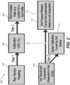
- FIG. 2 is a process flow 200 for an embodiment of a logic model depicting the analysis of data received from the soil sensors (1021 in FIG. 3 ) using the system 1000.
- the raw sensor data is received from the sensors 1021.
- the data is then analyzed to determine volume water content (VWC) of the soil (step 204).
- VWC volume water content
- the plat available water for a given location where the sensor is located is determined and a soil profile is produced.
- soil texture composition is determined from the received sensor data or from available automatic landform inference mapping (ALIM) data, or from a combination of both (step 208).
- the sensor data is calibrated to determine a curve based on the soil texture. This is used in step 204 to calibrate the VWC of the soil.
- the data from step 208 may also be used to determine soil pressure release curves from experiments based on soil composition.
- the data from step 212 can then be used to further determine the plant available water at step 206.
- FIG. 3 is a high-level diagram showing the components of the exemplary crop management system 1000 for analyzing soil data and performing other analyses described herein, and related components.
- the system 1000 includes a processor 1086, a peripheral system 1020, a user interface system 1030, and a data storage system 1040.
- the peripheral system 1020, the user interface system 1030 and the data storage system 1040 are communicatively connected to the processor 1086.
- Processor 1086 can be communicatively connected to network 1050 (shown in phantom), e.g., the Internet or a leased line, as discussed below.
- the moisture and temperature data may be received using sensors 1021 and/or displayed using display units (included in user interface system 1030) which can each include one or more of systems 1086, 1020, 1030, 1040, and can each connect to one or more network(s) 1050.
- Sensors 1021 may comprise temperature sensors, moisture sensors, pressure sensors, or any combination thereof.
- Processor 1086, and other processing devices described herein, can each include one or more microprocessors, microcontrollers, field-programmable gate arrays (FPGAs), application-specific integrated circuits (ASICs), programmable logic devices (PLDs), programmable logic arrays (PLAs), programmable array logic devices (PALs), or digital signal processors (DSPs).
- FPGAs field-programmable gate arrays
- ASICs application-specific integrated circuits
- PLDs programmable logic devices
- PLAs programmable logic arrays
- PALs programmable array logic devices
- DSPs digital signal processors
- Processor 1086 can implement processes of various aspects described herein.
- Processor 1086 can be or include one or more device(s) for automatically operating on data, e.g., a central processing unit (CPU), microcontroller (MCU), desktop computer, laptop computer, mainframe computer, personal digital assistant, digital camera, cellular phone, smartphone, or any other device for processing data, managing data, or handling data, whether implemented with electrical, magnetic, optical, biological components, or otherwise.
- Processor 1086 can include Harvard-architecture components, modified-Harvard-architecture components, or Von-Neumann-architecture components.
- the phrase "communicatively connected” includes any type of connection, wired or wireless, for communicating data between devices or processors. These devices or processors can be located in physical proximity or not. For example, subsystems such as peripheral system 1020, user interface system 1030, and data storage system 1040 are shown separately from the data processing system 1086 but can be stored completely or partially within the data processing system 1086.
- the peripheral system 1020 can include one or more devices configured to provide digital content records to the processor 1086.
- the peripheral system 1020 can include digital still cameras, digital video cameras, cellular phones, or other data processors.
- the processor 1086 upon receipt of digital content records from a device in the peripheral system 1020, can store such digital content records in the data storage system 1040.
- the user interface system 1030 can include a mouse, a keyboard, another computer (connected, e.g., via a network or a null-modem cable), or any device or combination of devices from which data is input to the processor 1086.
- the user interface system 1030 also can include a display device, a processor-accessible memory, or any device or combination of devices to which data is output by the processor 1086.
- the user interface system 1030 and the data storage system 1040 can share a processor-accessible memory.
- processor 1086 includes or is connected to communication interface 1015 that is coupled via network link 1016 (shown in phantom) to network 1050.
- communication interface 1015 can include an integrated services digital network (ISDN) terminal adapter or a modem to communicate data via a telephone line; a network interface to communicate data via a local-area network (LAN), e.g., an Ethernet LAN, or wide-area network (WAN); or a radio to communicate data via a wireless link, e.g., WiFi or GSM.
- ISDN integrated services digital network
- LAN local-area network
- WAN wide-area network
- Radio e.g., WiFi or GSM.
- Communication interface 1015 sends and receives electrical, electromagnetic or optical signals that carry digital or analog data streams representing various types of information across network link 1016 to network 1050.
- Network link 1016 can be connected to network 1050 via a switch, gateway, hub, router, or other networking device.
- Processor 1086 can send messages and receive data, including program code, through network 1050, network link 1016 and communication interface 1015.
- a server can store requested code for an application program (e.g., a JAVA applet) on a tangible non-volatile computer-readable storage medium to which it is connected.
- the server can retrieve the code from the medium and transmit it through network 1050 to communication interface 1015.
- the received code can be executed by processor 1086 as it is received, or stored in data storage system 1040 for later execution.
- Data storage system 1040 can include or be communicatively connected with one or more processor-accessible memories configured to store information.
- the memories can be, e.g., within a chassis or as parts of a distributed system.
- processor-accessible memory is intended to include any data storage device to or from which processor 1086 can transfer data (using appropriate components of peripheral system 1020), whether volatile or nonvolatile; removable or fixed; electronic, magnetic, optical, chemical, mechanical, or otherwise.
- processor-accessible memories include but are not limited to: registers, floppy disks, hard disks, tapes, bar codes, Compact Discs, DVDs, read-only memories (ROM), erasable programmable read-only memories (EPROM, EEPROM, or Flash), and random-access memories (RAMs).
- One of the processor-accessible memories in the data storage system 1040 can be a tangible non-transitory computer-readable storage medium, i.e., a non-transitory device or article of manufacture that participates in storing instructions that can be provided to processor 1086 for execution.
- data storage system 1040 includes code memory 1041, e.g., a RAM, and disk 1043, e.g., a tangible computer-readable rotational storage device such as a hard drive.
- Code memory 1041 e.g., a RAM
- disk 1043 e.g., a tangible computer-readable rotational storage device such as a hard drive.
- Computer program instructions are read into code memory 1041 from disk 1043.
- Processor 1086 then executes one or more sequences of the computer program instructions loaded into code memory 1041, as a result performing process steps described herein. In this way, processor 1086 carries out a computer implemented process.
- steps of methods described herein, blocks of the flowchart illustrations or block diagrams herein, and combinations of those, can be implemented by computer program instructions.
- Code memory 1041 can also store data, or can store only code.
- aspects described herein may be embodied as systems or methods. Accordingly, various aspects herein may take the form of an entirely hardware aspect, an entirely software aspect (including firmware, resident software, micro-code, etc.), or an aspect combining software and hardware aspects These aspects can all generally be referred to herein as a "service,” “circuit,” “circuitry,” “module,” or “system.”
- various aspects herein may be embodied as computer program products including computer readable program code stored on a tangible non-transitory computer readable medium. Such a medium can be manufactured as is conventional for such articles, e.g., by pressing a CD-ROM.
- the program code includes computer program instructions that can be loaded into processor 1086 (and possibly also other processors), to cause functions, acts, or operational steps of various aspects herein to be performed by the processor 1086 (or other processor).
- Computer program code for carrying out operations for various aspects described herein may be written in any combination of one or more programming language(s), and can be loaded from disk 1043 into code memory 1041 for execution.
- the program code may execute, e.g., entirely on processor 1086, partly on processor 1086 and partly on a remote computer connected to network 1050, or entirely on the remote computer.
Landscapes
- Life Sciences & Earth Sciences (AREA)
- Engineering & Computer Science (AREA)
- Physics & Mathematics (AREA)
- General Physics & Mathematics (AREA)
- Health & Medical Sciences (AREA)
- Chemical & Material Sciences (AREA)
- Automation & Control Theory (AREA)
- Environmental Sciences (AREA)
- General Life Sciences & Earth Sciences (AREA)
- General Health & Medical Sciences (AREA)
- Geology (AREA)
- Remote Sensing (AREA)
- Pathology (AREA)
- Water Supply & Treatment (AREA)
- Food Science & Technology (AREA)
- Medicinal Chemistry (AREA)
- Analytical Chemistry (AREA)
- Biochemistry (AREA)
- Environmental & Geological Engineering (AREA)
- Immunology (AREA)
- Botany (AREA)
- Soil Sciences (AREA)
- Management, Administration, Business Operations System, And Electronic Commerce (AREA)
- Radar Systems Or Details Thereof (AREA)
Claims (15)
- Verfahren zum Bereitstellen einer dreidimensionalen Beurteilung einer Wasserbewegung durch den Boden und über ein Feld, wobei das Verfahren Folgendes umfasst:Verwenden eines Computers, Empfangen von Temperatur- und Feuchtigkeitsdaten von einer Vielzahl von Temperatur- und Feuchtigkeitssensoren, wobei die Sensoren auf einem landwirtschaftlichen Feld angeordnet sind, wobei die Sensoren ein Sensornetzwerk bereitstellen, das Feuchtigkeits- und Temperatursensoren auf dem Feld kombiniert, um die Verfügbarkeit und die Eigenschaften einer Bodenfeuchtigkeit und -temperatur auf einem hohen Niveau der Datenauflösung in der gesamten Erntegutwurzelzone und im gesamten Bodenprofil zu verfolgen;Bestimmen eines volumetrischen Wassergehalts für einen auf dem Feld enthaltenen Bodenbereich;Bestimmen eines Niveaus der räumlichen und zeitlichen Variabilität in dem Bereich, die eine Variabilität durch eine Wurzelzone des Bodens beinhaltet;Bestimmen eines für Pflanzen verfügbaren Wasserniveaus (206) für den Bodenbereich;Bereitstellen einer dreidimensionalen Beurteilung einer Wasserbewegung durch den Boden und über das Feld, um es zu ermöglichen, auf räumliche und zeitliche Variationen in Echtzeit zu reagieren; undAnzeigen von Resultaten der Beurteilung auf einer elektronischen Schnittstelle (1030) für einen Benutzer.
- Verfahren nach Anspruch 1, das ferner das Bestimmen einer Bodentextur und eines Zusammensetzungsprofils (208) für den Bodenbereich umfasst.
- Verfahren nach Anspruch 1 oder 2, das ferner das Bestimmen einer Sensorkalibrierungskennlinie auf Basis der Bodentextur und des Zusammensetzungsprofils (210) umfasst.
- Verfahren nach einem der Ansprüche 1 bis 3, das ferner das Kalibrieren des volumetrischen Wassergehalts (204) für den Bodenbereich auf Basis der Sensorkennlinie umfasst.
- Verfahren nach einem der Ansprüche 1 bis 4, das ferner das Bestimmen einer Bodendruckentlastungskennlinie (212) auf Basis der Bodentextur und des Zusammensetzungsprofils für den Bodenbereich umfasst.
- Verfahren nach einem der Ansprüche 1 bis 5, das ferner die Bestimmung des für Pflanzen verfügbaren Wassers auf Basis der Bodendruckentlastungskennlinie umfasst.
- Verfahren nach einem der Ansprüche 3 bis 6, wobei die Sensorkalibrierungskennlinie anhand von a) Daten, die von den Temperatur- und Feuchtigkeitssensoren empfangen werden; oder b) ALIM-Daten bestimmt wird.
- Verfahren nach einem der Ansprüche 1 bis 7, das ferner Folgendes umfasst: für jeden einer Vielzahl von Bodenbereichen Bestimmen einer gewichteten Interpolation von für Pflanzen verfügbarem Wasser im Bodenbereich anhand von für Pflanzen verfügbaren Wasserniveaus, die für eine Vielzahl von Punkten im Bodenbereich bestimmt werden.
- Verfahren nach einem der Ansprüche 1 bis 8, das ferner das Mitteln von bestimmten Werten von für Pflanzen verfügbarem Wasser und das Erzeugen einer Raumkarte auf Basis einer Distanzinterpolation und Topographie umfasst, um auf einer elektronischen Anzeige eine Flusssimulation zu erzeugen.
- Verfahren nach einem der Ansprüche 1 bis 9, das ferner das Steuern eines Bewässerungssystems umfasst, das mit dem Prozessor wirkverbunden ist, um auf Basis des für Pflanzen verfügbaren Wassers eine Bewässerungsausgabe anzupassen.
- Verfahren nach einem der Ansprüche 1 bis 10, das ferner Folgendes umfasst: Bestimmen eines vorhergesagten Erntedatums auf Basis der empfangenen Informationen und wahlweise das Aktualisieren des vorhergesagten Erntedatums auf Basis von neu erfassten Sensordaten.
- Verfahren nach einem der Ansprüche 1 bis 11, das ferner das Vorhersagen einer Zusammensetzungsvariation von Pflanzenattributen umfasst.
- Verfahren nach Anspruch 12, wobei das Vorhersagen für separate Blöcke des Feldes bestimmt wird.
- Verfahren nach einem der Ansprüche 1 bis 13, das ferner das Erstellen einer Raumvariationskarte umfasst, die Pflanzenkomponentenbereiche anzeigt, die bei einem Ziel, über einem Ziel oder unter einem Ziel liegen.
- System (1000), das zum Durchführen des wie in einem der Ansprüche 1 bis 14 definierten Verfahrens geeignet ist, wobei das System Folgendes umfasst:einen Speicher (1041);einen Computerprozessor (1086), der mit dem Speicher wirkverbunden ist; undeine Vielzahl von Temperatur- und Feuchtigkeitssensoren (1021), wobei die Sensoren auf einem landwirtschaftlichen Feld angeordnet und mit dem Prozessor wirkverbunden sind,wobei die Sensoren ein Sensornetzwerk bereitstellen, das Feuchtigkeits- und Temperatursensoren auf dem Feld kombiniert, um die Verfügbarkeit und die Eigenschaften einer Bodenfeuchtigkeit und -temperatur auf einem hohen Niveau der Datenauflösung in der gesamten Erntegutwurzelzone und im gesamten Bodenprofil zu verfolgen;wobei der Prozessor zu Folgendem ausgelegt ist:Empfangen von Temperatur- und Feuchtigkeitsdaten von der Vielzahl von Temperatur- und Feuchtigkeitssensoren;Bestimmen eines volumetrischen Wassergehalts für einen auf dem Feld enthaltenen Bodenbereich;Bestimmen eines Niveaus der räumlichen und zeitlichen Variabilität in dem Bereich, die eine Variabilität durch eine Wurzelzone des Bodens beinhaltet;Bestimmen eines für Pflanzen verfügbaren Wasserniveaus (206) für den Bodenbereich;Bereitstellen einer dreidimensionalen Beurteilung einer Wasserbewegung durch den Boden und über das Feld, um es zu ermöglichen, auf räumliche und zeitliche Variationen in Echtzeit zu reagieren; undAnzeigen von Resultaten der Beurteilung auf einer elektronischen Schnittstelle (1030) für einen Benutzer.
Applications Claiming Priority (2)
| Application Number | Priority Date | Filing Date | Title |
|---|---|---|---|
| US201462073731P | 2014-10-31 | 2014-10-31 | |
| PCT/US2015/058683 WO2016070195A1 (en) | 2014-10-31 | 2015-11-02 | Moisture management & perennial crop sustainability decision system |
Publications (4)
| Publication Number | Publication Date |
|---|---|
| EP3211987A1 EP3211987A1 (de) | 2017-09-06 |
| EP3211987A4 EP3211987A4 (de) | 2018-06-20 |
| EP3211987C0 EP3211987C0 (de) | 2023-06-07 |
| EP3211987B1 true EP3211987B1 (de) | 2023-06-07 |
Family
ID=55858460
Family Applications (1)
| Application Number | Title | Priority Date | Filing Date |
|---|---|---|---|
| EP15856005.2A Active EP3211987B1 (de) | 2014-10-31 | 2015-11-02 | Verfahren zur dreidimensionalen bewertung der wasserbewegung durch den boden und über ein feld und zugehöriges system |
Country Status (4)
| Country | Link |
|---|---|
| US (1) | US11191227B2 (de) |
| EP (1) | EP3211987B1 (de) |
| ES (1) | ES2951703T3 (de) |
| WO (1) | WO2016070195A1 (de) |
Families Citing this family (45)
| Publication number | Priority date | Publication date | Assignee | Title |
|---|---|---|---|---|
| US11026376B2 (en) * | 2015-08-05 | 2021-06-08 | Dtn, Llc | Customized land surface modeling in a soil-crop system using satellite data to detect irrigation and precipitation events for decision support in precision agriculture |
| WO2017024254A1 (en) * | 2015-08-05 | 2017-02-09 | Iteris, Inc. | Customized land surface modeling for irrigation decision support in a crop and agronomic advisory service in precision agriculture |
| JP6363579B2 (ja) * | 2015-09-30 | 2018-07-25 | 株式会社クボタ | 圃場管理システム |
| US10143148B2 (en) * | 2016-05-13 | 2018-12-04 | Ceres Imaging Inc. | Methods and devices for assessing a field of plants for irrigation |
| WO2018009482A1 (en) * | 2016-07-05 | 2018-01-11 | Sostena, Inc. | System and method for crop management |
| US20180116124A1 (en) * | 2016-10-28 | 2018-05-03 | Deere & Company | Methods and systems for more efficient hay creation |
| US20180116121A1 (en) * | 2016-10-28 | 2018-05-03 | Deere & Company | Methods and systems for more efficient hay creation |
| DE102016120663A1 (de) | 2016-10-28 | 2018-05-03 | Endress+Hauser (Schweiz) AG | Verfahren zur automatisierten in-line Erkennung von Abweichungen eines Ist-Zustands eines Fluides von einem Referenzzustand des Fluides |
| USRE50733E1 (en) | 2016-11-07 | 2026-01-06 | FarmX Inc. | Systems and methods for harmonic analysis of soil |
| WO2018085452A1 (en) * | 2016-11-07 | 2018-05-11 | FarmX Inc. | Systems and Methods for Soil Modeling and Automatic Irrigation Control |
| EP4241549A3 (de) | 2016-11-07 | 2024-03-20 | Climate LLC | Landwirtschaftliches arbeitsgerät zur bodenanalyse |
| US10533956B2 (en) | 2016-12-14 | 2020-01-14 | FarmX Inc. | Multi-depth soil moisture monitoring systems and methods to evaluate soil type, packaged in small round polyvinyl chloride tube, with potting and rodent protection, for effective measurements and installation |
| US10746720B2 (en) | 2017-01-13 | 2020-08-18 | FarmX Inc. | Soil moisture monitoring systems and methods for measuring mutual inductance of area of influence using radio frequency stimulus |
| US11519896B2 (en) | 2017-01-13 | 2022-12-06 | FarmX Inc. | Soil moisture monitoring systems and methods for measuring mutual inductance of area of influence using radio frequency stimulus |
| AU2018261077B2 (en) | 2017-05-02 | 2023-05-11 | Centaur Analytics, Inc. | Systems and methods for post-harvest crop quality and pest management |
| WO2019033158A1 (en) * | 2017-08-14 | 2019-02-21 | Rubicon Research Pty Ltd | METHOD AND SYSTEM FOR WATER DISTRIBUTION AND HUMIDITY DETERMINATION OF SOIL |
| US11562444B2 (en) | 2017-11-09 | 2023-01-24 | Climate Llc | Hybrid seed selection and seed portfolio optimization by field |
| US11568340B2 (en) | 2017-11-09 | 2023-01-31 | Climate Llc | Hybrid seed selection and seed portfolio optimization by field |
| CN107691623A (zh) * | 2017-11-12 | 2018-02-16 | 连云港市农业科学院 | 一种葡萄水培生根保鲜方法 |
| US11423492B2 (en) | 2017-11-21 | 2022-08-23 | Climate Llc | Computing risk from a crop damaging factor for a crop on an agronomic field |
| CA2987761A1 (en) * | 2017-12-06 | 2019-06-06 | South Country Equipment Ltd. | Water-driven crop yield potential forecasting |
| US20240330827A1 (en) * | 2017-12-06 | 2024-10-03 | South Country Equipment Ltd | Irrigation control using forecast crop yield potential |
| CN108760643B (zh) * | 2018-04-04 | 2021-03-16 | 西南石油大学 | 一种适宜于高海拔地区的干旱遥感监测方法 |
| US11166404B2 (en) | 2018-09-02 | 2021-11-09 | FarmX Inc. | Systems and methods for virtual agronomic sensing |
| WO2020047587A1 (en) * | 2018-09-04 | 2020-03-12 | Robert Bosch (Australia) Pty Ltd | System and method for sensor-based auto-calibration of soil-moisture levels |
| CN109102447A (zh) * | 2018-09-25 | 2018-12-28 | 西安邮电大学 | 一种水土保持多指标动态实时监测系统 |
| US11058074B2 (en) * | 2018-10-08 | 2021-07-13 | Taiwan Semiconductor Manufacturing Co., Ltd. | Apparatus, systems and methods for irrigating lands |
| CN109460789B (zh) * | 2018-11-07 | 2021-07-27 | 中国农业科学院农田灌溉研究所 | 一种基于贝叶斯最大熵的土壤水分融合方法 |
| US11334575B2 (en) | 2019-01-30 | 2022-05-17 | International Business Machines Corporation | Integrating relational database temporal tables with a distributed programming environment |
| CN109858186B (zh) * | 2019-03-11 | 2022-06-03 | 武汉大学 | 联合光学和热学数据的农田干旱评估方法 |
| CN109906861A (zh) * | 2019-04-22 | 2019-06-21 | 棕榈生态城镇发展股份有限公司 | 一种木兰科植物耐涝性的评价鉴定方法 |
| US11375655B2 (en) | 2019-06-25 | 2022-07-05 | Cnh Industrial America Llc | System and method for dispensing agricultural products into a field using an agricultural machine based on cover crop density |
| WO2021007363A1 (en) * | 2019-07-09 | 2021-01-14 | The Texas A&M University System | Irrigation control with deep reinforcement learning and smart scheduling |
| CN111178761A (zh) * | 2019-12-30 | 2020-05-19 | 成都工业学院 | 基于gis技术的城市地下空间模型管理方法和系统 |
| US11645308B2 (en) * | 2020-05-27 | 2023-05-09 | International Business Machines Corporation | Customizing agricultural practices to maximize crop yield |
| US11464179B2 (en) | 2020-07-31 | 2022-10-11 | FarmX Inc. | Systems providing irrigation optimization using sensor networks and soil moisture modeling |
| US12235747B2 (en) * | 2020-08-07 | 2025-02-25 | Kyndryl, Inc. | Dynamic risk based analysis model |
| US12013245B2 (en) * | 2020-10-09 | 2024-06-18 | Deere & Company | Predictive map generation and control system |
| US12056744B2 (en) | 2021-03-02 | 2024-08-06 | International Business Machines Corporation | Commerce driven feedback mechanism for consumer products |
| FR3122063B1 (fr) * | 2021-04-22 | 2023-04-28 | Kuhn S A S | Procédé de réglage et/ou de calibrage d’une machine agricole |
| US12153189B2 (en) * | 2022-04-20 | 2024-11-26 | Deere & Company | Method and system for mapping cut crop moisture in a field |
| CN116298202A (zh) * | 2023-03-14 | 2023-06-23 | 华南农业大学 | 柑橘育苗水分胁迫监测系统、方法、计算机设备及介质 |
| CN116990490B (zh) * | 2023-09-26 | 2023-12-26 | 中国标准化研究院 | 一种基于物联网的土壤水分动态监测系统及方法 |
| CN117237145B (zh) * | 2023-11-14 | 2024-02-13 | 北京宏数科技有限公司 | 一种基于大数据的传感器数据处理方法及系统 |
| CN121364295B (zh) * | 2025-12-22 | 2026-03-27 | 中国科学院南京土壤研究所 | 基于大数据分析的水稻土壤养分协同调控方法及系统 |
Family Cites Families (13)
| Publication number | Priority date | Publication date | Assignee | Title |
|---|---|---|---|---|
| AU2002953346A0 (en) * | 2002-12-16 | 2003-01-09 | Sentek Pty Ltd | Soil matric potential and salinity measurement apparatus and method of use |
| US20100094472A1 (en) * | 2008-10-14 | 2010-04-15 | Woytowitz Peter J | Irrigation System With Soil Moisture Based Seasonal Watering Adjustment |
| US7793559B2 (en) * | 2007-02-02 | 2010-09-14 | Board Of Regents Of The Nevada System Of Higher Education, On Behalf Of The Desert Research Institute | Monitoring probes and methods of use |
| US8024074B2 (en) * | 2007-12-07 | 2011-09-20 | Deere & Company | System and method of managing substances in a plant root zone |
| US20090177330A1 (en) | 2007-12-20 | 2009-07-09 | Kah Jr Carl L C | Wireless moisture probe, receiving controller and irrigation control system |
| TR200805998A2 (tr) * | 2008-08-12 | 2009-12-21 | Kodalfa B�Lg� Ve �Let���M Teknoloj�Ler� Sanay� Ve T�Caret A.�. | Seralar için uzaktan kablosuz iklim gözlemleme ve kontrol sistemi |
| US8340910B1 (en) * | 2009-02-02 | 2012-12-25 | Green Badge LLC | Method and system for monitoring soil and water resources |
| WO2010129168A2 (en) * | 2009-05-08 | 2010-11-11 | Pioneer Hi-Bred International, Inc. | Real-time process for targeting trait phenotyping of plant breeding experiments |
| US20120284264A1 (en) * | 2010-03-31 | 2012-11-08 | David Lankford | Methods and Systems for Monitoring Crop Management and Transport |
| US20130104455A1 (en) * | 2011-05-13 | 2013-05-02 | David P. Groeneveld | Method and System for Remote Sensing and Limited Field Sampling to Prescribe and Deliver Soil Amendments Targeted Discretely Across Cultivated Fields |
| WO2013012826A1 (en) | 2011-07-15 | 2013-01-24 | Earthtec Solutions Llc | Crop-specific automated irrigation and nutrient management |
| HK1214919A1 (zh) * | 2012-11-06 | 2016-08-12 | Landcare Research New Zealand Limited | 一个方法和系统用作自动化微分灌溉 |
| US20140236868A1 (en) * | 2013-02-15 | 2014-08-21 | Banyan Water, Inc. | System and method for automated, range-based irrigation |
-
2015
- 2015-11-02 EP EP15856005.2A patent/EP3211987B1/de active Active
- 2015-11-02 ES ES15856005T patent/ES2951703T3/es active Active
- 2015-11-02 US US15/523,619 patent/US11191227B2/en active Active
- 2015-11-02 WO PCT/US2015/058683 patent/WO2016070195A1/en not_active Ceased
Also Published As
| Publication number | Publication date |
|---|---|
| EP3211987C0 (de) | 2023-06-07 |
| EP3211987A4 (de) | 2018-06-20 |
| US20170311559A1 (en) | 2017-11-02 |
| US11191227B2 (en) | 2021-12-07 |
| ES2951703T3 (es) | 2023-10-24 |
| EP3211987A1 (de) | 2017-09-06 |
| WO2016070195A1 (en) | 2016-05-06 |
Similar Documents
| Publication | Publication Date | Title |
|---|---|---|
| EP3211987B1 (de) | Verfahren zur dreidimensionalen bewertung der wasserbewegung durch den boden und über ein feld und zugehöriges system | |
| Cheng et al. | Combining multi-indicators with machine-learning algorithms for maize yield early prediction at the county-level in China | |
| US20220067614A1 (en) | Apparatus and method for crop yield prediction | |
| Pei et al. | The role of phenology in crop yield prediction: Comparison of ground-based phenology and remotely sensed phenology | |
| Sirsat et al. | Machine Learning predictive model of grapevine yield based on agroclimatic patterns | |
| US20160180473A1 (en) | Systems to prescribe and deliver fertilizer over agricultural fields and related methods | |
| Bonfante et al. | Terroir analysis and its complexity: This article is published in cooperation with Terclim 2022 (XIVth International Terroir Congress and 2nd ClimWine Symposium), 3-8 July 2022, Bordeaux, France. | |
| Silva et al. | Irrigation in the age of agriculture 4.0: management, monitoring and precision | |
| de Oliveira Aparecido et al. | Maturation periods for Coffea arabica cultivars and their implications for yield and quality in Brazil | |
| Ohana-Levi et al. | Evaluation of within-season grapevine evapotranspiration patterns and drivers using generalized additive models | |
| Ferretti | Topoclimate and wine quality: Results of research on the Gewürztraminer grape variety in South Tyrol, northern Italy | |
| Rafique et al. | Developing a simple and efficient modeling solution for predicting key phenological stages of table grapes in a non-traditional viticulture zone in south Asia | |
| Kirby et al. | Review of water, crop production and system modelling approaches for food security studies in the Eastern Gangetic Plains | |
| Gundim et al. | Precision irrigation trends and perspectives: a review | |
| CN120146497A (zh) | 一种考虑盐分胁迫与冻融机制的区域棉花水肥动态决策方法 | |
| Goh et al. | Monitoring winter wheat growth performance at sub-field scale using multitemporal Sentinel-2 imagery | |
| Bhamini et al. | The role of GIS and GPS in precision fertilization: Optimizing nutrient management for sustainable cropping | |
| Liu et al. | Winter wheat maturity date prediction using MODIS/ECMWF data: Accuracy evaluation and spatiotemporal variation analysis | |
| Bicamumakuba et al. | Sensor technologies for remote monitoring of automated orchard irrigation: A review | |
| CN120391306B (zh) | 一种西兰花根区交替灌溉装置的智能控制方法及系统 | |
| Nayak et al. | New generation technologies for precision nutrient management for sustainable agriculture | |
| Suciu et al. | IoT agro-meteorology for viticulture disease warning | |
| Taylor et al. | Can within-season grapevine predawn leaf water potentials be predicted from meteorological data in non-irrigated Mediterranean vineyards? | |
| Shaikh et al. | Planting prediction using soil parameter | |
| Galvão et al. | Greenhouse Digitalization and Water Irrigation Nutrient Liquid Management |
Legal Events
| Date | Code | Title | Description |
|---|---|---|---|
| STAA | Information on the status of an ep patent application or granted ep patent |
Free format text: STATUS: THE INTERNATIONAL PUBLICATION HAS BEEN MADE |
|
| PUAI | Public reference made under article 153(3) epc to a published international application that has entered the european phase |
Free format text: ORIGINAL CODE: 0009012 |
|
| STAA | Information on the status of an ep patent application or granted ep patent |
Free format text: STATUS: REQUEST FOR EXAMINATION WAS MADE |
|
| 17P | Request for examination filed |
Effective date: 20170529 |
|
| AK | Designated contracting states |
Kind code of ref document: A1 Designated state(s): AL AT BE BG CH CY CZ DE DK EE ES FI FR GB GR HR HU IE IS IT LI LT LU LV MC MK MT NL NO PL PT RO RS SE SI SK SM TR |
|
| AX | Request for extension of the european patent |
Extension state: BA ME |
|
| DAV | Request for validation of the european patent (deleted) | ||
| DAX | Request for extension of the european patent (deleted) | ||
| A4 | Supplementary search report drawn up and despatched |
Effective date: 20180524 |
|
| RIC1 | Information provided on ipc code assigned before grant |
Ipc: G05D 7/06 20060101ALI20180517BHEP Ipc: E02D 1/04 20060101ALI20180517BHEP Ipc: A01G 17/02 20060101ALI20180517BHEP Ipc: G05D 22/02 20060101ALI20180517BHEP Ipc: A01G 22/00 20180101ALI20180517BHEP Ipc: G08B 21/20 20060101ALI20180517BHEP Ipc: G01N 33/24 20060101ALI20180517BHEP Ipc: A01G 25/16 20060101AFI20180517BHEP |
|
| STAA | Information on the status of an ep patent application or granted ep patent |
Free format text: STATUS: EXAMINATION IS IN PROGRESS |
|
| 17Q | First examination report despatched |
Effective date: 20190812 |
|
| GRAP | Despatch of communication of intention to grant a patent |
Free format text: ORIGINAL CODE: EPIDOSNIGR1 |
|
| STAA | Information on the status of an ep patent application or granted ep patent |
Free format text: STATUS: GRANT OF PATENT IS INTENDED |
|
| INTG | Intention to grant announced |
Effective date: 20211025 |
|
| GRAJ | Information related to disapproval of communication of intention to grant by the applicant or resumption of examination proceedings by the epo deleted |
Free format text: ORIGINAL CODE: EPIDOSDIGR1 |
|
| STAA | Information on the status of an ep patent application or granted ep patent |
Free format text: STATUS: EXAMINATION IS IN PROGRESS |
|
| INTC | Intention to grant announced (deleted) | ||
| GRAP | Despatch of communication of intention to grant a patent |
Free format text: ORIGINAL CODE: EPIDOSNIGR1 |
|
| STAA | Information on the status of an ep patent application or granted ep patent |
Free format text: STATUS: GRANT OF PATENT IS INTENDED |
|
| INTG | Intention to grant announced |
Effective date: 20220719 |
|
| GRAS | Grant fee paid |
Free format text: ORIGINAL CODE: EPIDOSNIGR3 |
|
| GRAA | (expected) grant |
Free format text: ORIGINAL CODE: 0009210 |
|
| STAA | Information on the status of an ep patent application or granted ep patent |
Free format text: STATUS: THE PATENT HAS BEEN GRANTED |
|
| AK | Designated contracting states |
Kind code of ref document: B1 Designated state(s): AL AT BE BG CH CY CZ DE DK EE ES FI FR GB GR HR HU IE IS IT LI LT LU LV MC MK MT NL NO PL PT RO RS SE SI SK SM TR |
|
| REG | Reference to a national code |
Ref country code: GB Ref legal event code: FG4D |
|
| REG | Reference to a national code |
Ref country code: CH Ref legal event code: EP Ref country code: AT Ref legal event code: REF Ref document number: 1571872 Country of ref document: AT Kind code of ref document: T Effective date: 20230615 |
|
| REG | Reference to a national code |
Ref country code: DE Ref legal event code: R096 Ref document number: 602015084034 Country of ref document: DE |
|
| U01 | Request for unitary effect filed |
Effective date: 20230706 |
|
| U07 | Unitary effect registered |
Designated state(s): AT BE BG DE DK EE FI FR IT LT LU LV MT NL PT SE SI Effective date: 20230718 |
|
| REG | Reference to a national code |
Ref country code: LT Ref legal event code: MG9D |
|
| REG | Reference to a national code |
Ref country code: ES Ref legal event code: FG2A Ref document number: 2951703 Country of ref document: ES Kind code of ref document: T3 Effective date: 20231024 |
|
| PG25 | Lapsed in a contracting state [announced via postgrant information from national office to epo] |
Ref country code: NO Free format text: LAPSE BECAUSE OF FAILURE TO SUBMIT A TRANSLATION OF THE DESCRIPTION OR TO PAY THE FEE WITHIN THE PRESCRIBED TIME-LIMIT Effective date: 20230907 |
|
| PG25 | Lapsed in a contracting state [announced via postgrant information from national office to epo] |
Ref country code: RS Free format text: LAPSE BECAUSE OF FAILURE TO SUBMIT A TRANSLATION OF THE DESCRIPTION OR TO PAY THE FEE WITHIN THE PRESCRIBED TIME-LIMIT Effective date: 20230607 Ref country code: HR Free format text: LAPSE BECAUSE OF FAILURE TO SUBMIT A TRANSLATION OF THE DESCRIPTION OR TO PAY THE FEE WITHIN THE PRESCRIBED TIME-LIMIT Effective date: 20230607 Ref country code: GR Free format text: LAPSE BECAUSE OF FAILURE TO SUBMIT A TRANSLATION OF THE DESCRIPTION OR TO PAY THE FEE WITHIN THE PRESCRIBED TIME-LIMIT Effective date: 20230908 |
|
| U20 | Renewal fee for the european patent with unitary effect paid |
Year of fee payment: 9 Effective date: 20231127 |
|
| PG25 | Lapsed in a contracting state [announced via postgrant information from national office to epo] |
Ref country code: SK Free format text: LAPSE BECAUSE OF FAILURE TO SUBMIT A TRANSLATION OF THE DESCRIPTION OR TO PAY THE FEE WITHIN THE PRESCRIBED TIME-LIMIT Effective date: 20230607 |
|
| PG25 | Lapsed in a contracting state [announced via postgrant information from national office to epo] |
Ref country code: IS Free format text: LAPSE BECAUSE OF FAILURE TO SUBMIT A TRANSLATION OF THE DESCRIPTION OR TO PAY THE FEE WITHIN THE PRESCRIBED TIME-LIMIT Effective date: 20231007 |
|
| PG25 | Lapsed in a contracting state [announced via postgrant information from national office to epo] |
Ref country code: SM Free format text: LAPSE BECAUSE OF FAILURE TO SUBMIT A TRANSLATION OF THE DESCRIPTION OR TO PAY THE FEE WITHIN THE PRESCRIBED TIME-LIMIT Effective date: 20230607 Ref country code: SK Free format text: LAPSE BECAUSE OF FAILURE TO SUBMIT A TRANSLATION OF THE DESCRIPTION OR TO PAY THE FEE WITHIN THE PRESCRIBED TIME-LIMIT Effective date: 20230607 Ref country code: RO Free format text: LAPSE BECAUSE OF FAILURE TO SUBMIT A TRANSLATION OF THE DESCRIPTION OR TO PAY THE FEE WITHIN THE PRESCRIBED TIME-LIMIT Effective date: 20230607 Ref country code: IS Free format text: LAPSE BECAUSE OF FAILURE TO SUBMIT A TRANSLATION OF THE DESCRIPTION OR TO PAY THE FEE WITHIN THE PRESCRIBED TIME-LIMIT Effective date: 20231007 Ref country code: CZ Free format text: LAPSE BECAUSE OF FAILURE TO SUBMIT A TRANSLATION OF THE DESCRIPTION OR TO PAY THE FEE WITHIN THE PRESCRIBED TIME-LIMIT Effective date: 20230607 |
|
| PG25 | Lapsed in a contracting state [announced via postgrant information from national office to epo] |
Ref country code: PL Free format text: LAPSE BECAUSE OF FAILURE TO SUBMIT A TRANSLATION OF THE DESCRIPTION OR TO PAY THE FEE WITHIN THE PRESCRIBED TIME-LIMIT Effective date: 20230607 |
|
| REG | Reference to a national code |
Ref country code: DE Ref legal event code: R097 Ref document number: 602015084034 Country of ref document: DE |
|
| PLBE | No opposition filed within time limit |
Free format text: ORIGINAL CODE: 0009261 |
|
| STAA | Information on the status of an ep patent application or granted ep patent |
Free format text: STATUS: NO OPPOSITION FILED WITHIN TIME LIMIT |
|
| 26N | No opposition filed |
Effective date: 20240308 |
|
| REG | Reference to a national code |
Ref country code: CH Ref legal event code: PL |
|
| PG25 | Lapsed in a contracting state [announced via postgrant information from national office to epo] |
Ref country code: MC Free format text: LAPSE BECAUSE OF FAILURE TO SUBMIT A TRANSLATION OF THE DESCRIPTION OR TO PAY THE FEE WITHIN THE PRESCRIBED TIME-LIMIT Effective date: 20230607 |
|
| PG25 | Lapsed in a contracting state [announced via postgrant information from national office to epo] |
Ref country code: CH Free format text: LAPSE BECAUSE OF NON-PAYMENT OF DUE FEES Effective date: 20231130 |
|
| PG25 | Lapsed in a contracting state [announced via postgrant information from national office to epo] |
Ref country code: MC Free format text: LAPSE BECAUSE OF FAILURE TO SUBMIT A TRANSLATION OF THE DESCRIPTION OR TO PAY THE FEE WITHIN THE PRESCRIBED TIME-LIMIT Effective date: 20230607 Ref country code: CH Free format text: LAPSE BECAUSE OF NON-PAYMENT OF DUE FEES Effective date: 20231130 |
|
| REG | Reference to a national code |
Ref country code: IE Ref legal event code: MM4A |
|
| PG25 | Lapsed in a contracting state [announced via postgrant information from national office to epo] |
Ref country code: IE Free format text: LAPSE BECAUSE OF NON-PAYMENT OF DUE FEES Effective date: 20231102 |
|
| PG25 | Lapsed in a contracting state [announced via postgrant information from national office to epo] |
Ref country code: IE Free format text: LAPSE BECAUSE OF NON-PAYMENT OF DUE FEES Effective date: 20231102 |
|
| U20 | Renewal fee for the european patent with unitary effect paid |
Year of fee payment: 10 Effective date: 20241127 |
|
| PG25 | Lapsed in a contracting state [announced via postgrant information from national office to epo] |
Ref country code: CY Free format text: LAPSE BECAUSE OF FAILURE TO SUBMIT A TRANSLATION OF THE DESCRIPTION OR TO PAY THE FEE WITHIN THE PRESCRIBED TIME-LIMIT; INVALID AB INITIO Effective date: 20151102 |
|
| PG25 | Lapsed in a contracting state [announced via postgrant information from national office to epo] |
Ref country code: HU Free format text: LAPSE BECAUSE OF FAILURE TO SUBMIT A TRANSLATION OF THE DESCRIPTION OR TO PAY THE FEE WITHIN THE PRESCRIBED TIME-LIMIT; INVALID AB INITIO Effective date: 20151102 |
|
| PG25 | Lapsed in a contracting state [announced via postgrant information from national office to epo] |
Ref country code: TR Free format text: LAPSE BECAUSE OF FAILURE TO SUBMIT A TRANSLATION OF THE DESCRIPTION OR TO PAY THE FEE WITHIN THE PRESCRIBED TIME-LIMIT Effective date: 20230607 |
|
| U20 | Renewal fee for the european patent with unitary effect paid |
Year of fee payment: 11 Effective date: 20251126 |
|
| PGFP | Annual fee paid to national office [announced via postgrant information from national office to epo] |
Ref country code: GB Payment date: 20251127 Year of fee payment: 11 |
|
| PGFP | Annual fee paid to national office [announced via postgrant information from national office to epo] |
Ref country code: ES Payment date: 20251201 Year of fee payment: 11 |