EP3108453B1 - Verfahren zur auswahl von datendateien zum herunterladen - Google Patents
Verfahren zur auswahl von datendateien zum herunterladen Download PDFInfo
- Publication number
- EP3108453B1 EP3108453B1 EP15706747.1A EP15706747A EP3108453B1 EP 3108453 B1 EP3108453 B1 EP 3108453B1 EP 15706747 A EP15706747 A EP 15706747A EP 3108453 B1 EP3108453 B1 EP 3108453B1
- Authority
- EP
- European Patent Office
- Prior art keywords
- node
- data
- data files
- selection process
- client device
- Prior art date
- Legal status (The legal status is an assumption and is not a legal conclusion. Google has not performed a legal analysis and makes no representation as to the accuracy of the status listed.)
- Active
Links
- 238000000034 method Methods 0.000 title claims description 87
- 238000009877 rendering Methods 0.000 claims description 17
- 238000004364 calculation method Methods 0.000 claims 1
- 238000012986 modification Methods 0.000 description 2
- 230000004048 modification Effects 0.000 description 2
- 238000012546 transfer Methods 0.000 description 2
- 238000004891 communication Methods 0.000 description 1
- 238000011960 computer-aided design Methods 0.000 description 1
- 230000001419 dependent effect Effects 0.000 description 1
- 230000003993 interaction Effects 0.000 description 1
- 238000005192 partition Methods 0.000 description 1
Images


Classifications
-
- G—PHYSICS
- G06—COMPUTING; CALCULATING OR COUNTING
- G06F—ELECTRIC DIGITAL DATA PROCESSING
- G06F16/00—Information retrieval; Database structures therefor; File system structures therefor
- G06F16/10—File systems; File servers
- G06F16/18—File system types
- G06F16/182—Distributed file systems
-
- G—PHYSICS
- G06—COMPUTING; CALCULATING OR COUNTING
- G06T—IMAGE DATA PROCESSING OR GENERATION, IN GENERAL
- G06T17/00—Three dimensional [3D] modelling, e.g. data description of 3D objects
- G06T17/005—Tree description, e.g. octree, quadtree
-
- G—PHYSICS
- G06—COMPUTING; CALCULATING OR COUNTING
- G06F—ELECTRIC DIGITAL DATA PROCESSING
- G06F16/00—Information retrieval; Database structures therefor; File system structures therefor
- G06F16/10—File systems; File servers
- G06F16/18—File system types
- G06F16/185—Hierarchical storage management [HSM] systems, e.g. file migration or policies thereof
-
- G—PHYSICS
- G06—COMPUTING; CALCULATING OR COUNTING
- G06F—ELECTRIC DIGITAL DATA PROCESSING
- G06F16/00—Information retrieval; Database structures therefor; File system structures therefor
- G06F16/20—Information retrieval; Database structures therefor; File system structures therefor of structured data, e.g. relational data
- G06F16/24—Querying
- G06F16/245—Query processing
- G06F16/2455—Query execution
-
- G—PHYSICS
- G06—COMPUTING; CALCULATING OR COUNTING
- G06F—ELECTRIC DIGITAL DATA PROCESSING
- G06F16/00—Information retrieval; Database structures therefor; File system structures therefor
- G06F16/20—Information retrieval; Database structures therefor; File system structures therefor of structured data, e.g. relational data
- G06F16/29—Geographical information databases
-
- G—PHYSICS
- G06—COMPUTING; CALCULATING OR COUNTING
- G06F—ELECTRIC DIGITAL DATA PROCESSING
- G06F16/00—Information retrieval; Database structures therefor; File system structures therefor
- G06F16/50—Information retrieval; Database structures therefor; File system structures therefor of still image data
- G06F16/51—Indexing; Data structures therefor; Storage structures
-
- G—PHYSICS
- G06—COMPUTING; CALCULATING OR COUNTING
- G06F—ELECTRIC DIGITAL DATA PROCESSING
- G06F16/00—Information retrieval; Database structures therefor; File system structures therefor
- G06F16/50—Information retrieval; Database structures therefor; File system structures therefor of still image data
- G06F16/58—Retrieval characterised by using metadata, e.g. metadata not derived from the content or metadata generated manually
- G06F16/583—Retrieval characterised by using metadata, e.g. metadata not derived from the content or metadata generated manually using metadata automatically derived from the content
-
- G—PHYSICS
- G06—COMPUTING; CALCULATING OR COUNTING
- G06T—IMAGE DATA PROCESSING OR GENERATION, IN GENERAL
- G06T17/00—Three dimensional [3D] modelling, e.g. data description of 3D objects
- G06T17/05—Geographic models
-
- G—PHYSICS
- G06—COMPUTING; CALCULATING OR COUNTING
- G06T—IMAGE DATA PROCESSING OR GENERATION, IN GENERAL
- G06T2207/00—Indexing scheme for image analysis or image enhancement
- G06T2207/10—Image acquisition modality
- G06T2207/10028—Range image; Depth image; 3D point clouds
-
- G—PHYSICS
- G06—COMPUTING; CALCULATING OR COUNTING
- G06T—IMAGE DATA PROCESSING OR GENERATION, IN GENERAL
- G06T2207/00—Indexing scheme for image analysis or image enhancement
- G06T2207/30—Subject of image; Context of image processing
- G06T2207/30168—Image quality inspection
-
- G—PHYSICS
- G06—COMPUTING; CALCULATING OR COUNTING
- G06T—IMAGE DATA PROCESSING OR GENERATION, IN GENERAL
- G06T2210/00—Indexing scheme for image generation or computer graphics
- G06T2210/36—Level of detail
-
- G—PHYSICS
- G06—COMPUTING; CALCULATING OR COUNTING
- G06T—IMAGE DATA PROCESSING OR GENERATION, IN GENERAL
- G06T7/00—Image analysis
- G06T7/0002—Inspection of images, e.g. flaw detection
Definitions
- the present invention pertains to a method for selecting a set of data files of a multitude of data files for downloading. It is an improved method for quickly selecting only the necessary collection of data blocks from a multitude of data blocks for describing three-dimensional data from any viewing position or direction without explicitly having to compute a level of detail for any coordinate in the data.
- the invention also pertains to rendering data of a three-dimensional surface, particularly a terrain, having a multitude of detail levels, and to visualizing the rendered data.
- Rendering is the process of generating an image from a model such as a three-dimensional terrain model by means of a computer programme.
- the three-dimensional terrain model to be rendered can be a grid comprising elevation data, such as a Digital Elevation Model (DEM), a Digital Surface Model (DSM) or a Digital Terrain Model (DTM).
- the digital model may comprise data of a limited area, such as a model of a particular city or landscape, as well as a model of a continent or even the complete Earth.
- the memory of the device or the transfer speed of the data can become limiting factors. If the memory of the device is too small, not all of the data can be stored in the memory at the same time. If the network for the provision of the data is too slow, for instance in the case of a slow wireless internet connection, it may take too long to transfer all of the data over the network for an efficient use of the data. Therefore, it is important to partition the data in such a way that not all of the data needs to be stored in the memory of the device. This is especially important for mobile devices, which generally have particularly limited memory capacities.
- a common solution is to subdivide the data into smaller data blocks, wherein each of the data blocks describes a section of the data. Additionally, it is a common solution to create data blocks with several representation versions of each section, the representation versions having different detail levels. This allows describing a collection of data blocks having detail levels that can be used to render the data with sufficient quality, while still only a fraction of the original size of the complete data set has to be load or transferred.
- a tree structure which divides the data into tiles and different levels of detail, wherein each level of detail comprises more information than the previous one, thus allowing zooming in or out while keeping the rendering quality and preserving the amount of memory needed on the device.
- At least one of these objects is achieved by the method according to claim 1, the mobile device according to claim 8, the computer programme product according to claim 12 and/or the dependent claims of the present invention.
- at least one of these objects is achieved by an automatic pre-selection process before downloading the surface data.
- at least one of these objects is achieved by loading only exactly those data blocks that are needed for the display and nothing else, thus accepting temporary holes and gaps in the data until the loading and rendering of the data is complete.
- the surface data particularly comprises texture data and elevation data of a three-dimensional surface.
- a hierarchical file system is a data structure comprising a multitude of data files which are arranged in a tree.
- the tree (which, by convention, is considered growing downwards) has a root value and sub-trees of children, represented as a set of linked nodes.
- Each node in the tree has zero or more child nodes, which are below it in the tree.
- a node that has at least one child node is the parent node of the child node.
- a sibling node is a node that has the same parent node (i.e. two child nodes of the same parent node are sibling nodes), and an uncle node is a sibling node of the parent node.
- the selection process is resumed with a child node of the currently assessed node, and if the detail level meets the criteria of the quality factor, the data file of the currently assessed node is downloaded or designated for downloading from the server computer to the client device.
- designating a data file for downloading comprises storing an identifier of the data file in a node list.
- a mobile client device adapted for downloading selected data files of a multitude of data files from a server computer is disclosed according to the claims.
- the present invention also pertains to a computer programme product for execution of the method according to the claimed invention.
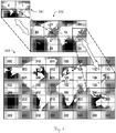
- Figure 1 shows an example for a representation of a terrain in three different detail levels 331-333.
- the representation is subdivided into a multitude of tiles, each of which particularly comprising a bitmap of a part of the representation.
- Each tile is assigned a number from which its position and detail level can be derived.
- each tile is comprised by a certain data file.
- the first detail level comprises the lowest amount of details.
- the terrain is subdivided into the four rectangular tiles with the numbers “0", “1”, “2” and “3”, each corresponding to four tiles of the second detail level 332 which is, thus, subdivided into sixteen tiles.
- Tile "2" of the first detail level e.g. corresponds to tiles “20", “21”, “22” and “23” of the second detail level.
- Each of the second detail level tiles corresponds to four tiles of the next higher level, the third detail level 333, so that this level is subdivided into sixty-four tiles.
- Tile "13” of the second detail level e.g. corresponds to tiles "130", “131", “132” and "133" of the second detail level.
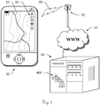
- FIG. 2 an exemplary embodiments of a server-client-system for execution of the method according to the invention is depicted.
- the depicted system comprises an exemplary embodiment of a mobile device 30 according to the invention.
- the device is hand-held and comprises a rendering unit (not shown) for rendering data representing physical features of a portion of a three-dimensional surface, particularly by a method according to the invention, as described further below.
- the mobile device furthermore comprises a display 31, particularly designed as a touchscreen, the display 31 being adapted for displaying an image based on the data rendered by the rendering unit, particularly a representation of a three-dimensional terrain.
- the display 31 comprises a zoom functionality 33 for zooming in and out, i.e. changing the detail level of the displayed data.
- the device furthermore comprises locating means, such as a GNSS receiver, and communicating means for wirelessly receiving the data from a remote server 40.
- the depicted mobile device 30 has communication means for establishing a connection with the server 40 via the internet 70 by means of a wireless connection 35 to a cell phone base station 75.
- data files are stored as nodes of a hierarchical file system 400, the data files comprising information about the three-dimensional terrain.
- a request unit of the mobile device 30 sends a request to the remote server 40 to provide a certain data file for downloading, the data file e.g. comprising a bitmap of a part of the terrain in a certain resolution level.
- the remote server 40 then sends the requested file to the mobile device 30, so that the information is displayable on the display 31.
- Figure 3 shows an exemplary hierarchical file system 400, wherein data files at a plurality of different detail levels 331-335 are stored as nodes of the file system 400.
- a node of such a hierarchical file system 400 can have as few as one or two child nodes, or as many as several dozens.
- the top node 410 In the first detail level 331 (comprising the fewest details) there is the top node 410.
- the top node 410 has three child nodes 421-423 in the second detail level 332, each of which having child nodes in the third detail level 333.
- node 423 has three child nodes 431-433, each of which having child nodes in the fourth detail level 334.
- node 433 has two child nodes 431,432, each of which having a child node 451,452 in the fifth detail level 335 (comprising the most details).
- An exemplary embodiment of the method according to the invention employs this hierarchical file system 400 to select those data files that are necessary for displaying a certain portion of the three-dimensional surface.
- the method comprises the step of confirming whether data from the respective node is needed for display, and - if it is needed - of determining whether the detail level of the respective node is sufficient in order to display the portion in accordance with a certain quality factor. Thereby, if the detail level is sufficient, the respective node is designated for a later download request - for instance an identifier of the respective data file is stored in a node list. If the detail level is not sufficient, the method is repeated for a child node of the respective node.
- the method could e.g. begin with the top node 410.
- the method continues with the first child node 421 of the top node 410.
- this node 421 turns out to be not necessary for displaying as it would not be visible in the representation. It is therefore marked with a cross.
- the method continues with the next child node 422 of the top node 410. As this node 422 neither is necessary for displaying, the method continues with the third child node 423 of the top node 410.
- This node 423 turns out to be necessary for displaying; its detail level 332 is not sufficient, though, so that the method continues with its child nodes 431-433.
- two nodes 451,452 of the fifth detail level 335 are necessary and sufficient for displaying. These nodes 451,452 are therefore designated for downloading, e. g. added to a node list.
- Figure 4 illustrates an exemplary embodiment of a method 100 for selecting data representing a portion of a three-dimensional surface for loading.
- the method relates to a hierarchical structure with nodes as depicted in Figure 3 and comprises an automatic selection process that is performed subsequently for a multitude of nodes of the hierarchical file system.
- the selection process is fully automatic, not requiring any user interaction.
- the selection process starts in step 110 with the top node of the hierarchical file system.
- step 120 the process goes downwards in the hierarchical structure to a child node of the top node. This child node is the first node to become the presently considered node of the selection process (in the following: "present node").
- step 130 it is assessed whether data comprised by the present node is needed for displaying an image with a representation of a particular portion of the three-dimensional surface, i.e. if the texture of the data would be visible in the representation if it were displayed on a display.
- step 160 the selection process continues one level higher in the hierarchical structure, i.e. going back to the parent node of the currently assessed node, where the selection process continues with another child node of that node, i.e. a sibling node of the last present node. If no unassessed child node of the parent node is left, the method continues with a parent node of the last present node's parent node and so on.
- step 130 If in step 130 it is confirmed that the data of the present node is needed, the process continues with step 140, where it is then determined, whether the surface data of the currently assessed node meets the criteria of a resolution quality factor, e. g. whether the level of detail of the data of the present node is sufficient.
- the resolution quality factor can be defined for instance by a user or some external process and is particularly predefined.
- a number of applicable quality factors for use in step 140 are described in WO 2006/033576 A1 .
- Examples of how to calculate the quality factor may include one or more of the following factors:
- step 150 an identifier of the present node is stored in a node list. If the surface data meets the criteria of the resolution quality factor, in step 150 an identifier of the present node is stored in a node list. If the surface data does not meet the criteria of the resolution quality factor, the process continues with step 175, determining whether the present node has a child node that is still unconsidered. If there is one, this child node becomes the new present node and the process starts again. If there is no further child node, the process continues with step 150, storing the identifier of the present node in the node list. Though the data has not met the criteria, there is no better data available.
- step 160 After having stored the identifier of the present node in the node list, the process continues in step 160 with the parent node of the present node and with determining, in step 170, whether there is another, still unconsidered child node of the parent node. If there is one, this child node becomes the new present node and the process starts again. If there is no further child node, the process continues in step 160 with the parent node of the present node. If there is no parent node (determined in step 180), all necessary nodes have been considered and the process is determined (step 190).
- the computed result of the selection process is a node list, which is generated in step 150.
- This node list can be used for a further method part, which is described in Figure 6 .
- the data can also be downloaded and displayed immediately.
- step 130 may be skipped if it is desired to additionally load data sections which are not immediately visible from the viewing position but which may be visible a few moments later due to a change of the viewing position or angle.
- Step 130 may also be used to adjust the quality factor used in step 140. In such cases the visibility calculated in step 130 may also be used to assign a priority for the order of which the data sections should be loaded or transferred over the network.
- Figure 5 shows am exemplary embodiment of a node list 15, as created in step 150 of the selection process of the method 100 described in Figure 4 .
- identifiers 151,152 of two data files designated for downloading from a server are stored, e. g. those corresponding to the two nodes 451,452 of Figure 3 .
- the node list 15 is used for a request for downloading the data files corresponding to the identifiers 151,152 stored therein, in order to allow displaying the data of the respective data files.
- Figure 6 illustrates an exemplary embodiment of an optional method part 200 for displaying a representation of a portion of a three-dimensional surface.
- This optional method part 200 can be a part of the method 100 described in Figure 4 and may e. g. be executed immediately after the termination of the process in step 190. Alternatively, it can be executed for every identifier that is stored in the node list in step 150 and while the automatic selection process continues.
- the method part 200 comprises the automatic steps of requesting 220 data files from a server, downloading 230 the requested data files from the server, and displaying 240 information comprised by the downloaded data files.
- the requested data files have previously been read 210 from a node list 15 (see Figure 5 ), which has been created by the selection process of the method 100 described in Figure 4 .
Landscapes
- Engineering & Computer Science (AREA)
- Physics & Mathematics (AREA)
- Theoretical Computer Science (AREA)
- General Physics & Mathematics (AREA)
- Software Systems (AREA)
- Geometry (AREA)
- Databases & Information Systems (AREA)
- Data Mining & Analysis (AREA)
- General Engineering & Computer Science (AREA)
- Computer Graphics (AREA)
- Remote Sensing (AREA)
- Library & Information Science (AREA)
- Computational Linguistics (AREA)
- Processing Or Creating Images (AREA)
- Information Transfer Between Computers (AREA)
Claims (12)
- Computerimplementiertes Verfahren (100) zum Auswählen eines Satzes von Datendateien aus einer Mehrzahl von Datendateien zum Herunterladen des ausgewählten Satzes von einem Server-Computer (40) auf eine Client-Vorrichtung (30),• wobei die Mehrzahl von Datendateien Oberflächendaten in einer Vielzahl von unterschiedlichen Detaillierungsgraden (331-335) umfasst, wobei die Oberflächendaten Texturdaten umfassen,• wobei die Oberflächendaten mit einem Abschnitt einer dreidimensionalen Oberfläche in einer Bildszene assoziiert sind,• wobei die Datendateien als Knoten eines hierarchischen Dateisystems (400) des Server-Computers (40) gespeichert sind, wobei jeder Knoten entweder ein Elternknoten oder ein Kindsknoten ist, und• wobei das Verfahren (100) einen automatischen Auswahlprozess umfasst, der nachfolgend für eine Mehrzahl von Knoten des hierarchischen Dateisystems (400) durchgeführt wird,wobei der Auswahlprozess ein Beurteilen (130) umfasst, ob der Abschnitt einer dreidimensionalen Oberfläche, mit welcher die Oberflächendaten eines gegenwärtig beurteilten Knotens assoziiert sind, in einer realen Bildszene sichtbar ist, wenn diese Bildszene auf einer Computeranzeige (31) angezeigt wird, wobei• wenn der Abschnitt der dreidimensionalen Oberfläche nicht sichtbar ist, der Auswahlprozess mit einem Geschwisterknoten oder Onkelknoten des gegenwärtig beurteilten Knotens fortgesetzt wird, und• wenn der Abschnitt der dreidimensionalen Oberfläche sichtbar ist, der Auswahlprozess zum Bestimmen (140) übergeht, ob die Oberflächendaten des gegenwärtig beurteilten Knotens die Kriterien eines vordefinierten Auflösungsqualitätsfaktors erfüllen,dadurch gekennzeichnet, dass,
wenn der Detaillierungsgrad die Kriterien des Qualitätsfaktors erfüllt, die Datendatei des gegenwärtig beurteilten Knotens zum Herunterladen von dem Server-Computer (40) auf die Client-Vorrichtung (30) durch Speichern (150) einer Kennung (151, 152) der Datendatei in einer Knotenliste (15) bestimmt wird, wobei das Verfahren ferner Folgendes umfasst:• Lesen (210) von Kennungen (151, 152) von aufgelisteten Datendateien aus der Knotenliste (15),• Anfordern (220) der aufgelisteten Datendateien von dem Server,• Herunterladen (230) der angeforderten Datendateien von dem Server-Computer, und• Anzeigen (240) von Informationen, die in den heruntergeladenen Datendateien enthalten sind; undandernfalls, wenn der Detaillierungsgrad die Kriterien des Qualitätsfaktors nicht erfüllt, der Auswahlprozess mit einem Kindsknoten des gegenwärtig beurteilten Knotens fortgesetzt wird. - Verfahren (100) nach Anspruch 1, wobei jeder Kindsknoten Oberflächendaten eines höheren Detaillierungsgrads (331-335) als sein entsprechender Elternknoten umfasst.
- Verfahren (100) nach einem der vorhergehenden Ansprüche, wobei der erste Knoten, der in dem Auswahlprozess beurteilt wird, ein Wurzelknoten (410) des hierarchischen Dateisystems (400) oder ein erster Kindsknoten (421) des Wurzelknotens (410) ist.
- Verfahren (100) nach einem der vorhergehenden Ansprüche, wobei der Qualitätsfaktor auf der Grundlage eines Abstands von der Oberfläche zu einem Beobachtungspunkt und mindestens einem der Folgenden berechnet wird:• einem Bildschirmabdeckungsfaktor in Bezug darauf, in welchem Ausmaß eine Textur eine Computeranzeigeoberfläche abdecken würde, wenn sie angezeigt wird;• einem Szenenabdeckungsfaktor in Bezug darauf, wie viel einer Textur eine Oberfläche abdeckt, die sich in einer Szene außerhalb einer Computeranzeigenkante befindet; und/oder• einem realen Bereich, den ein minimales Umschließungsvolumen von der Darstellungsoberfläche abdecken würde.
- Verfahren (100) nach Anspruch 5, wobei der Qualitätsfaktor auf der folgenden Gleichung basiert:

- Verfahren (100) nach Anspruch 5, wobei der Qualitätsfaktor definiert ist als


- Verfahren (100) nach einem der vorhergehenden Ansprüche, wobei der Auswahlprozess mindestens teilweise in der Client-Vorrichtung (30) durchgeführt wird, bei der sich insbesondere um eine mobile Vorrichtung handelt, wobei die Client-Vorrichtung (30) mit dem Server-Computer (40) verbunden ist, insbesondere über eine Internet-(70)-Verbindung.
- Mobile Client-Vorrichtung (30), die zum Herunterladen ausgewählter Datendateien aus einer Mehrzahl von Datendateien von einem Server-Computer (40) ausgelegt ist,• wobei die Mehrzahl von Datendateien Oberflächendaten in einer Vielzahl von unterschiedlichen Detaillierungsgraden (331-335) umfasst,• wobei die Oberflächendaten mit einem Abschnitt einer dreidimensionalen Oberfläche in einer Bildszene assoziiert sind, und• wobei die Datendateien als Knoten eines hierarchischen Dateisystems (400) des Server-Computers (40) gespeichert sind, wobei jeder Knoten entweder ein Elternknoten oder ein Kindsknoten ist,wobei die mobile Client-Vorrichtung (30) eine Rendereinheit zum Rendern der Oberflächendaten und eine Anzeige (31) zum Anzeigen der Darstellung umfasst,
dadurch gekennzeichnet, dass
die mobile Client-Vorrichtung (30) eine Auswahleinheit mit einem Auswahlalgorithmus umfasst, der zum nachfolgenden Durchführen eines automatischen Auswahlprozesses für eine Mehrheit von Knoten des hierarchischen Dateisystems (400) ausgelegt ist, wobei der Auswahlprozess Beurteilen (130) umfasst, ob der Abschnitt einer dreidimensionalen Oberfläche, wobei die Oberflächendaten eines gegenwärtig beurteilten Knotens damit assoziiert sind, in einer realen Bildszene sichtbar ist, wenn diese Bildszene auf der Anzeige (31) angezeigt wird, wobei• wenn der Abschnitt der dreidimensionalen Oberfläche nicht sichtbar ist, der Auswahlprozess mit einem Geschwisterknoten oder Onkelknoten des gegenwärtig beurteilten Knotens fortgesetzt wird,• wenn der Abschnitt der dreidimensionalen Oberfläche sichtbar ist, der Auswahlprozess zum Bestimmen (140) übergeht, ob die Oberflächendaten des gegenwärtig beurteilten Knotens die Kriterien eines vordefinierten Auflösungsqualitätsfaktors erfüllen, und• wenn der Detaillierungsgrad die Kriterien des Qualitätsfaktors erfüllt, die Datendatei des gegenwärtig beurteilten Knotens für eine Herunterladungsanforderung durch Speichern (150) einer Kennung (151, 152) der Datendatei in einer Knotenliste (15) bestimmt wird, und andernfalls, wenn der Detaillierungsgrad die Kriterien des Qualitätsfaktors nicht erfüllt, der Auswahlprozess mit einem Kindsknoten des gegenwärtig beurteilten Knotens fortgesetzt wird,wobei die mobile Client-Vorrichtung (30) ferner eine Anforderungseinheit umfasst, die zum Lesen (210) von Kennungen (151, 152) von aufgelisteten Datendateien aus der Knotenliste (15), Anfordern (220) der aufgelisteten Datendateien von dem Server-Computer (40) und Herunterladen (230) der angeforderten Datendateien ausgelegt ist. - Mobile Client-Vorrichtung (30) nach Anspruch 8, wobei• Ortungsmittel, insbesondere ein GNSS-Empfänger, zum Bestimmen eines aktuellen Standorts der Vorrichtung und/oder• Kommunikationsmittel zum drahtlosen Empfangen der Daten von dem Server-Computer (40), insbesondere über das Internet (70).
- Mobile Client-Vorrichtung (30) nach Anspruch 8 oder Anspruch 9, wobei jeder Kindsknoten Oberflächendaten eines höheren Detaillierungsgrads (331-335) als sein entsprechender Elternknoten umfasst.
- Mobile Client-Vorrichtung (30) nach einem der Ansprüche 8 bis 10, wobei der Qualitätsfaktor auf der Grundlage eines Abstands von dem Objekt zu einem Beobachtungspunkt und mindestens einem der Folgenden berechnet wird:• einem Bildschirmabdeckungsfaktor in Bezug darauf, in welchem Ausmaß eine Textur eine Computeranzeigeoberfläche abdecken würde, wenn sie angezeigt wird;• einem Szenenabdeckungsfaktor in Bezug darauf, wie viel einer Textur eine Oberfläche abdeckt, die sich in einer Szene außerhalb einer Computeranzeigenkante befindet; und/oder• einem realen Bereich, den ein minimales Umschließungsvolumen von der Darstellungsoberfläche abdecken würde.
- Computerprogrammprodukt, umfassend Programmcode, der auf einem maschinenlesbaren Medium gespeichert ist oder durch eine elektromagnetische Welle realisiert wird, die ein Programmcodesegment umfasst, und computerausführbare Anweisungen zum Durchführen, insbesondere bei Ausführung auf Rechenmitteln einer mobilen Client-Vorrichtung nach einem der Ansprüche 8 bis 11, der folgenden Schritte des Verfahrens nach einem der Ansprüche 1 bis 7 aufweist.
Applications Claiming Priority (2)
| Application Number | Priority Date | Filing Date | Title |
|---|---|---|---|
| EP14155789.2A EP2911118A1 (de) | 2014-02-19 | 2014-02-19 | Verfahren zur Auswahl von Datendateien zum Herunterladen |
| PCT/EP2015/053439 WO2015124641A1 (en) | 2014-02-19 | 2015-02-18 | Method for selecting data files for downloading |
Publications (2)
| Publication Number | Publication Date |
|---|---|
| EP3108453A1 EP3108453A1 (de) | 2016-12-28 |
| EP3108453B1 true EP3108453B1 (de) | 2020-01-01 |
Family
ID=50184739
Family Applications (2)
| Application Number | Title | Priority Date | Filing Date |
|---|---|---|---|
| EP14155789.2A Withdrawn EP2911118A1 (de) | 2014-02-19 | 2014-02-19 | Verfahren zur Auswahl von Datendateien zum Herunterladen |
| EP15706747.1A Active EP3108453B1 (de) | 2014-02-19 | 2015-02-18 | Verfahren zur auswahl von datendateien zum herunterladen |
Family Applications Before (1)
| Application Number | Title | Priority Date | Filing Date |
|---|---|---|---|
| EP14155789.2A Withdrawn EP2911118A1 (de) | 2014-02-19 | 2014-02-19 | Verfahren zur Auswahl von Datendateien zum Herunterladen |
Country Status (5)
| Country | Link |
|---|---|
| US (1) | US20170060901A1 (de) |
| EP (2) | EP2911118A1 (de) |
| KR (1) | KR101782873B1 (de) |
| CN (1) | CN105960659A (de) |
| WO (1) | WO2015124641A1 (de) |
Families Citing this family (7)
| Publication number | Priority date | Publication date | Assignee | Title |
|---|---|---|---|---|
| EP3364374A1 (de) * | 2017-02-20 | 2018-08-22 | My Virtual Reality Software AS | Verfahren zur visualisierung von dreidimensionalen daten |
| EP3418839B1 (de) * | 2017-06-22 | 2021-10-13 | Enisco by Forcam GmbH | Verfahren zur überwachung einer automatisierungsanlage |
| US11625848B2 (en) * | 2020-01-30 | 2023-04-11 | Unity Technologies Sf | Apparatus for multi-angle screen coverage analysis |
| CN111415411B (zh) * | 2020-03-02 | 2023-12-12 | 重庆市勘测院 | 三维模型空间坐标纠正及加密方法 |
| US11217208B2 (en) * | 2020-03-30 | 2022-01-04 | Adobe Inc. | Low-latency adaptive streaming for augmented reality scenes |
| CN113111141A (zh) * | 2020-12-31 | 2021-07-13 | 绍兴亿都信息技术股份有限公司 | 组件化服务式三维城市地理信息系统的海量数据管理方法 |
| CN117112574B (zh) * | 2023-10-20 | 2024-02-23 | 美云智数科技有限公司 | 树形业务数据构建方法、装置、计算机设备及存储介质 |
Family Cites Families (7)
| Publication number | Priority date | Publication date | Assignee | Title |
|---|---|---|---|---|
| US6496189B1 (en) | 1997-09-29 | 2002-12-17 | Skyline Software Systems Ltd. | Remote landscape display and pilot training |
| US20030158786A1 (en) | 1999-02-26 | 2003-08-21 | Skyline Software Systems, Inc. | Sending three-dimensional images over a network |
| US7283135B1 (en) * | 2002-06-06 | 2007-10-16 | Bentley Systems, Inc. | Hierarchical tile-based data structure for efficient client-server publishing of data over network connections |
| US20040006424A1 (en) * | 2002-06-28 | 2004-01-08 | Joyce Glenn J. | Control system for tracking and targeting multiple autonomous objects |
| CA2581153C (en) | 2004-09-20 | 2014-10-28 | My Virtual Reality Software As | Method, system and device for efficient distribution of real time three dimensional computer modeled image scenes over a network |
| US7388585B2 (en) * | 2004-09-20 | 2008-06-17 | My Virtual Reality Software | Method, system and device for efficient distribution of real time three dimensional computer modeled image scenes over a network |
| US9743373B2 (en) * | 2012-12-28 | 2017-08-22 | Trimble Inc. | Concurrent dual processing of pseudoranges with corrections |
-
2014
- 2014-02-19 EP EP14155789.2A patent/EP2911118A1/de not_active Withdrawn
-
2015
- 2015-02-18 EP EP15706747.1A patent/EP3108453B1/de active Active
- 2015-02-18 US US15/120,056 patent/US20170060901A1/en not_active Abandoned
- 2015-02-18 KR KR1020167019612A patent/KR101782873B1/ko active IP Right Grant
- 2015-02-18 WO PCT/EP2015/053439 patent/WO2015124641A1/en active Application Filing
- 2015-02-18 CN CN201580005008.XA patent/CN105960659A/zh active Pending
Non-Patent Citations (1)
| Title |
|---|
| None * |
Also Published As
| Publication number | Publication date |
|---|---|
| WO2015124641A1 (en) | 2015-08-27 |
| US20170060901A1 (en) | 2017-03-02 |
| CN105960659A (zh) | 2016-09-21 |
| EP3108453A1 (de) | 2016-12-28 |
| KR101782873B1 (ko) | 2017-09-29 |
| KR20160113123A (ko) | 2016-09-28 |
| EP2911118A1 (de) | 2015-08-26 |
Similar Documents
| Publication | Publication Date | Title |
|---|---|---|
| EP3108453B1 (de) | Verfahren zur auswahl von datendateien zum herunterladen | |
| US8274524B1 (en) | Map rendering using interpolation of style parameters across zoom levels | |
| EP2881918B1 (de) | Verfahren zur Visualisierung von dreidimensionalen Daten | |
| EP3334174A1 (de) | Verfahren und vorrichtung zur übertragung von video mit mehreren perspektiven | |
| CN106847068B (zh) | 一种地图转换方法、装置和计算设备 | |
| US8872848B1 (en) | Rendering vector data as tiles | |
| EP2209092A1 (de) | Verfahren zur vereinheitlichten Visualisierung von heterogenen Datensätzen | |
| US8976169B1 (en) | Rendering terrain patches | |
| TW200929066A (en) | Geospatial data system for selectively retrieving and displaying geospatial texture data in successive additive layers of resolution and related methods | |
| US9093006B2 (en) | Image shader using style attribute references | |
| EP2595118A2 (de) | Verfahren zur Bereitstellung von 3D-Gebäudeinformationen | |
| KR20130079819A (ko) | 절차적 방법에 의해 생성된 지형 데이터를 편집하는 방법 | |
| KR101953133B1 (ko) | 렌더링 장치 및 그 방법 | |
| WO2013060206A1 (zh) | 对层次细节模型中的图像进行缩放的方法和装置 | |
| EP2804151B1 (de) | Verfahren zur Darstellung von Daten einer dreidimensionalen Oberfläche | |
| KR101487454B1 (ko) | Lod 영상 병렬처리방법 | |
| CN109741448B (zh) | 基于dem数据绘制三维起伏模型的方法、装置以及设备 | |
| US9092907B2 (en) | Image shader using two-tiered lookup table for implementing style attribute references | |
| CN112687007A (zh) | 一种基于lod技术的立体网格图生成方法 | |
| CN111753038A (zh) | 一种地图数据的渲染方法及系统 | |
| JP6297169B2 (ja) | 描画装置、および描画方法 | |
| KR20140139194A (ko) | 지형 모델의 생성 방법 및 장치 | |
| Herzig et al. | X3D-earthbrowser: visualize our earth in your web browser | |
| US20130235038A1 (en) | Method for Preselecting Three-Dimensional Space for Triggering Automated Construction of a Three-Dimensional Structure | |
| CN114820967A (zh) | 一种分层影像数据实时绘制方法及系统 |
Legal Events
| Date | Code | Title | Description |
|---|---|---|---|
| PUAI | Public reference made under article 153(3) epc to a published international application that has entered the european phase |
Free format text: ORIGINAL CODE: 0009012 |
|
| STAA | Information on the status of an ep patent application or granted ep patent |
Free format text: STATUS: REQUEST FOR EXAMINATION WAS MADE |
|
| 17P | Request for examination filed |
Effective date: 20160624 |
|
| AK | Designated contracting states |
Kind code of ref document: A1 Designated state(s): AL AT BE BG CH CY CZ DE DK EE ES FI FR GB GR HR HU IE IS IT LI LT LU LV MC MK MT NL NO PL PT RO RS SE SI SK SM TR |
|
| AX | Request for extension of the european patent |
Extension state: BA ME |
|
| DAX | Request for extension of the european patent (deleted) | ||
| REG | Reference to a national code |
Ref country code: DE Ref legal event code: R079 Ref document number: 602015044604 Country of ref document: DE Free format text: PREVIOUS MAIN CLASS: G06T0017000000 Ipc: G06T0017050000 |
|
| GRAP | Despatch of communication of intention to grant a patent |
Free format text: ORIGINAL CODE: EPIDOSNIGR1 |
|
| STAA | Information on the status of an ep patent application or granted ep patent |
Free format text: STATUS: GRANT OF PATENT IS INTENDED |
|
| RIC1 | Information provided on ipc code assigned before grant |
Ipc: G06T 17/05 20110101AFI20190711BHEP Ipc: G06T 17/00 20060101ALI20190711BHEP |
|
| INTG | Intention to grant announced |
Effective date: 20190808 |
|
| RIN1 | Information on inventor provided before grant (corrected) |
Inventor name: KRISTIANSEN, STIG RONALD |
|
| GRAJ | Information related to disapproval of communication of intention to grant by the applicant or resumption of examination proceedings by the epo deleted |
Free format text: ORIGINAL CODE: EPIDOSDIGR1 |
|
| STAA | Information on the status of an ep patent application or granted ep patent |
Free format text: STATUS: REQUEST FOR EXAMINATION WAS MADE |
|
| GRAR | Information related to intention to grant a patent recorded |
Free format text: ORIGINAL CODE: EPIDOSNIGR71 |
|
| GRAS | Grant fee paid |
Free format text: ORIGINAL CODE: EPIDOSNIGR3 |
|
| STAA | Information on the status of an ep patent application or granted ep patent |
Free format text: STATUS: GRANT OF PATENT IS INTENDED |
|
| INTC | Intention to grant announced (deleted) | ||
| GRAJ | Information related to disapproval of communication of intention to grant by the applicant or resumption of examination proceedings by the epo deleted |
Free format text: ORIGINAL CODE: EPIDOSDIGR1 |
|
| STAA | Information on the status of an ep patent application or granted ep patent |
Free format text: STATUS: REQUEST FOR EXAMINATION WAS MADE |
|
| INTG | Intention to grant announced |
Effective date: 20191015 |
|
| GRAR | Information related to intention to grant a patent recorded |
Free format text: ORIGINAL CODE: EPIDOSNIGR71 |
|
| GRAS | Grant fee paid |
Free format text: ORIGINAL CODE: EPIDOSNIGR3 |
|
| STAA | Information on the status of an ep patent application or granted ep patent |
Free format text: STATUS: GRANT OF PATENT IS INTENDED |
|
| GRAA | (expected) grant |
Free format text: ORIGINAL CODE: 0009210 |
|
| STAA | Information on the status of an ep patent application or granted ep patent |
Free format text: STATUS: THE PATENT HAS BEEN GRANTED |
|
| INTC | Intention to grant announced (deleted) | ||
| AK | Designated contracting states |
Kind code of ref document: B1 Designated state(s): AL AT BE BG CH CY CZ DE DK EE ES FI FR GB GR HR HU IE IS IT LI LT LU LV MC MK MT NL NO PL PT RO RS SE SI SK SM TR |
|
| INTG | Intention to grant announced |
Effective date: 20191125 |
|
| REG | Reference to a national code |
Ref country code: GB Ref legal event code: FG4D |
|
| REG | Reference to a national code |
Ref country code: CH Ref legal event code: EP Ref country code: AT Ref legal event code: REF Ref document number: 1220763 Country of ref document: AT Kind code of ref document: T Effective date: 20200115 |
|
| REG | Reference to a national code |
Ref country code: IE Ref legal event code: FG4D |
|
| REG | Reference to a national code |
Ref country code: DE Ref legal event code: R096 Ref document number: 602015044604 Country of ref document: DE |
|
| REG | Reference to a national code |
Ref country code: NL Ref legal event code: MP Effective date: 20200101 |
|
| REG | Reference to a national code |
Ref country code: LT Ref legal event code: MG4D |
|
| PG25 | Lapsed in a contracting state [announced via postgrant information from national office to epo] |
Ref country code: RS Free format text: LAPSE BECAUSE OF FAILURE TO SUBMIT A TRANSLATION OF THE DESCRIPTION OR TO PAY THE FEE WITHIN THE PRESCRIBED TIME-LIMIT Effective date: 20200101 Ref country code: LT Free format text: LAPSE BECAUSE OF FAILURE TO SUBMIT A TRANSLATION OF THE DESCRIPTION OR TO PAY THE FEE WITHIN THE PRESCRIBED TIME-LIMIT Effective date: 20200101 Ref country code: NL Free format text: LAPSE BECAUSE OF FAILURE TO SUBMIT A TRANSLATION OF THE DESCRIPTION OR TO PAY THE FEE WITHIN THE PRESCRIBED TIME-LIMIT Effective date: 20200101 Ref country code: NO Free format text: LAPSE BECAUSE OF FAILURE TO SUBMIT A TRANSLATION OF THE DESCRIPTION OR TO PAY THE FEE WITHIN THE PRESCRIBED TIME-LIMIT Effective date: 20200401 Ref country code: PT Free format text: LAPSE BECAUSE OF FAILURE TO SUBMIT A TRANSLATION OF THE DESCRIPTION OR TO PAY THE FEE WITHIN THE PRESCRIBED TIME-LIMIT Effective date: 20200527 Ref country code: CZ Free format text: LAPSE BECAUSE OF FAILURE TO SUBMIT A TRANSLATION OF THE DESCRIPTION OR TO PAY THE FEE WITHIN THE PRESCRIBED TIME-LIMIT Effective date: 20200101 Ref country code: FI Free format text: LAPSE BECAUSE OF FAILURE TO SUBMIT A TRANSLATION OF THE DESCRIPTION OR TO PAY THE FEE WITHIN THE PRESCRIBED TIME-LIMIT Effective date: 20200101 |
|
| PG25 | Lapsed in a contracting state [announced via postgrant information from national office to epo] |
Ref country code: SE Free format text: LAPSE BECAUSE OF FAILURE TO SUBMIT A TRANSLATION OF THE DESCRIPTION OR TO PAY THE FEE WITHIN THE PRESCRIBED TIME-LIMIT Effective date: 20200101 Ref country code: LV Free format text: LAPSE BECAUSE OF FAILURE TO SUBMIT A TRANSLATION OF THE DESCRIPTION OR TO PAY THE FEE WITHIN THE PRESCRIBED TIME-LIMIT Effective date: 20200101 Ref country code: GR Free format text: LAPSE BECAUSE OF FAILURE TO SUBMIT A TRANSLATION OF THE DESCRIPTION OR TO PAY THE FEE WITHIN THE PRESCRIBED TIME-LIMIT Effective date: 20200402 Ref country code: HR Free format text: LAPSE BECAUSE OF FAILURE TO SUBMIT A TRANSLATION OF THE DESCRIPTION OR TO PAY THE FEE WITHIN THE PRESCRIBED TIME-LIMIT Effective date: 20200101 Ref country code: IS Free format text: LAPSE BECAUSE OF FAILURE TO SUBMIT A TRANSLATION OF THE DESCRIPTION OR TO PAY THE FEE WITHIN THE PRESCRIBED TIME-LIMIT Effective date: 20200501 Ref country code: BG Free format text: LAPSE BECAUSE OF FAILURE TO SUBMIT A TRANSLATION OF THE DESCRIPTION OR TO PAY THE FEE WITHIN THE PRESCRIBED TIME-LIMIT Effective date: 20200401 |
|
| REG | Reference to a national code |
Ref country code: CH Ref legal event code: PL |
|
| REG | Reference to a national code |
Ref country code: DE Ref legal event code: R097 Ref document number: 602015044604 Country of ref document: DE |
|
| REG | Reference to a national code |
Ref country code: BE Ref legal event code: MM Effective date: 20200229 |
|
| PG25 | Lapsed in a contracting state [announced via postgrant information from national office to epo] |
Ref country code: SK Free format text: LAPSE BECAUSE OF FAILURE TO SUBMIT A TRANSLATION OF THE DESCRIPTION OR TO PAY THE FEE WITHIN THE PRESCRIBED TIME-LIMIT Effective date: 20200101 Ref country code: RO Free format text: LAPSE BECAUSE OF FAILURE TO SUBMIT A TRANSLATION OF THE DESCRIPTION OR TO PAY THE FEE WITHIN THE PRESCRIBED TIME-LIMIT Effective date: 20200101 Ref country code: LU Free format text: LAPSE BECAUSE OF NON-PAYMENT OF DUE FEES Effective date: 20200218 Ref country code: ES Free format text: LAPSE BECAUSE OF FAILURE TO SUBMIT A TRANSLATION OF THE DESCRIPTION OR TO PAY THE FEE WITHIN THE PRESCRIBED TIME-LIMIT Effective date: 20200101 Ref country code: MC Free format text: LAPSE BECAUSE OF FAILURE TO SUBMIT A TRANSLATION OF THE DESCRIPTION OR TO PAY THE FEE WITHIN THE PRESCRIBED TIME-LIMIT Effective date: 20200101 Ref country code: EE Free format text: LAPSE BECAUSE OF FAILURE TO SUBMIT A TRANSLATION OF THE DESCRIPTION OR TO PAY THE FEE WITHIN THE PRESCRIBED TIME-LIMIT Effective date: 20200101 Ref country code: SM Free format text: LAPSE BECAUSE OF FAILURE TO SUBMIT A TRANSLATION OF THE DESCRIPTION OR TO PAY THE FEE WITHIN THE PRESCRIBED TIME-LIMIT Effective date: 20200101 Ref country code: DK Free format text: LAPSE BECAUSE OF FAILURE TO SUBMIT A TRANSLATION OF THE DESCRIPTION OR TO PAY THE FEE WITHIN THE PRESCRIBED TIME-LIMIT Effective date: 20200101 |
|
| PLBE | No opposition filed within time limit |
Free format text: ORIGINAL CODE: 0009261 |
|
| STAA | Information on the status of an ep patent application or granted ep patent |
Free format text: STATUS: NO OPPOSITION FILED WITHIN TIME LIMIT |
|
| REG | Reference to a national code |
Ref country code: AT Ref legal event code: MK05 Ref document number: 1220763 Country of ref document: AT Kind code of ref document: T Effective date: 20200101 |
|
| PG25 | Lapsed in a contracting state [announced via postgrant information from national office to epo] |
Ref country code: CH Free format text: LAPSE BECAUSE OF NON-PAYMENT OF DUE FEES Effective date: 20200229 Ref country code: LI Free format text: LAPSE BECAUSE OF NON-PAYMENT OF DUE FEES Effective date: 20200229 |
|
| 26N | No opposition filed |
Effective date: 20201002 |
|
| PG25 | Lapsed in a contracting state [announced via postgrant information from national office to epo] |
Ref country code: AT Free format text: LAPSE BECAUSE OF FAILURE TO SUBMIT A TRANSLATION OF THE DESCRIPTION OR TO PAY THE FEE WITHIN THE PRESCRIBED TIME-LIMIT Effective date: 20200101 Ref country code: IE Free format text: LAPSE BECAUSE OF NON-PAYMENT OF DUE FEES Effective date: 20200218 Ref country code: FR Free format text: LAPSE BECAUSE OF NON-PAYMENT OF DUE FEES Effective date: 20200301 Ref country code: IT Free format text: LAPSE BECAUSE OF FAILURE TO SUBMIT A TRANSLATION OF THE DESCRIPTION OR TO PAY THE FEE WITHIN THE PRESCRIBED TIME-LIMIT Effective date: 20200101 |
|
| PG25 | Lapsed in a contracting state [announced via postgrant information from national office to epo] |
Ref country code: BE Free format text: LAPSE BECAUSE OF NON-PAYMENT OF DUE FEES Effective date: 20200229 Ref country code: SI Free format text: LAPSE BECAUSE OF FAILURE TO SUBMIT A TRANSLATION OF THE DESCRIPTION OR TO PAY THE FEE WITHIN THE PRESCRIBED TIME-LIMIT Effective date: 20200101 Ref country code: PL Free format text: LAPSE BECAUSE OF FAILURE TO SUBMIT A TRANSLATION OF THE DESCRIPTION OR TO PAY THE FEE WITHIN THE PRESCRIBED TIME-LIMIT Effective date: 20200101 |
|
| GBPC | Gb: european patent ceased through non-payment of renewal fee |
Effective date: 20200401 |
|
| PG25 | Lapsed in a contracting state [announced via postgrant information from national office to epo] |
Ref country code: GB Free format text: LAPSE BECAUSE OF NON-PAYMENT OF DUE FEES Effective date: 20200401 |
|
| PG25 | Lapsed in a contracting state [announced via postgrant information from national office to epo] |
Ref country code: TR Free format text: LAPSE BECAUSE OF FAILURE TO SUBMIT A TRANSLATION OF THE DESCRIPTION OR TO PAY THE FEE WITHIN THE PRESCRIBED TIME-LIMIT Effective date: 20200101 Ref country code: MT Free format text: LAPSE BECAUSE OF FAILURE TO SUBMIT A TRANSLATION OF THE DESCRIPTION OR TO PAY THE FEE WITHIN THE PRESCRIBED TIME-LIMIT Effective date: 20200101 Ref country code: CY Free format text: LAPSE BECAUSE OF FAILURE TO SUBMIT A TRANSLATION OF THE DESCRIPTION OR TO PAY THE FEE WITHIN THE PRESCRIBED TIME-LIMIT Effective date: 20200101 |
|
| PG25 | Lapsed in a contracting state [announced via postgrant information from national office to epo] |
Ref country code: MK Free format text: LAPSE BECAUSE OF FAILURE TO SUBMIT A TRANSLATION OF THE DESCRIPTION OR TO PAY THE FEE WITHIN THE PRESCRIBED TIME-LIMIT Effective date: 20200101 Ref country code: AL Free format text: LAPSE BECAUSE OF FAILURE TO SUBMIT A TRANSLATION OF THE DESCRIPTION OR TO PAY THE FEE WITHIN THE PRESCRIBED TIME-LIMIT Effective date: 20200101 |
|
| PGFP | Annual fee paid to national office [announced via postgrant information from national office to epo] |
Ref country code: DE Payment date: 20240219 Year of fee payment: 10 |