EP2863174A1 - Measuring method and measuring instrument - Google Patents
Measuring method and measuring instrument Download PDFInfo
- Publication number
- EP2863174A1 EP2863174A1 EP20140187172 EP14187172A EP2863174A1 EP 2863174 A1 EP2863174 A1 EP 2863174A1 EP 20140187172 EP20140187172 EP 20140187172 EP 14187172 A EP14187172 A EP 14187172A EP 2863174 A1 EP2863174 A1 EP 2863174A1
- Authority
- EP
- European Patent Office
- Prior art keywords
- measured
- image
- sighting
- unit
- measurement
- Prior art date
- Legal status (The legal status is an assumption and is not a legal conclusion. Google has not performed a legal analysis and makes no representation as to the accuracy of the status listed.)
- Granted
Links
- 238000000034 method Methods 0.000 title claims description 15
- 238000012544 monitoring process Methods 0.000 claims abstract description 15
- 238000005259 measurement Methods 0.000 claims description 96
- 238000012545 processing Methods 0.000 claims description 39
- 239000002131 composite material Substances 0.000 claims description 19
- 230000003287 optical effect Effects 0.000 description 35
- 238000004891 communication Methods 0.000 description 5
- 238000006073 displacement reaction Methods 0.000 description 5
- 238000001514 detection method Methods 0.000 description 3
- 238000010586 diagram Methods 0.000 description 3
- 230000005856 abnormality Effects 0.000 description 2
- 238000010276 construction Methods 0.000 description 2
- 238000002310 reflectometry Methods 0.000 description 1
- 230000000007 visual effect Effects 0.000 description 1
Images


Classifications
-
- G—PHYSICS
- G01—MEASURING; TESTING
- G01C—MEASURING DISTANCES, LEVELS OR BEARINGS; SURVEYING; NAVIGATION; GYROSCOPIC INSTRUMENTS; PHOTOGRAMMETRY OR VIDEOGRAMMETRY
- G01C3/00—Measuring distances in line of sight; Optical rangefinders
- G01C3/02—Details
- G01C3/06—Use of electric means to obtain final indication
- G01C3/08—Use of electric radiation detectors
-
- G—PHYSICS
- G01—MEASURING; TESTING
- G01C—MEASURING DISTANCES, LEVELS OR BEARINGS; SURVEYING; NAVIGATION; GYROSCOPIC INSTRUMENTS; PHOTOGRAMMETRY OR VIDEOGRAMMETRY
- G01C1/00—Measuring angles
- G01C1/02—Theodolites
- G01C1/04—Theodolites combined with cameras
-
- G—PHYSICS
- G01—MEASURING; TESTING
- G01C—MEASURING DISTANCES, LEVELS OR BEARINGS; SURVEYING; NAVIGATION; GYROSCOPIC INSTRUMENTS; PHOTOGRAMMETRY OR VIDEOGRAMMETRY
- G01C15/00—Surveying instruments or accessories not provided for in groups G01C1/00 - G01C13/00
- G01C15/002—Active optical surveying means
Definitions
- the present invention relates to a measuring method and a measuring instrument which measures a multiple number of points periodically or continuously over time.
- a multiple number of measuring points set in a measurement range are measured periodically or continuously over time by a measuring instrument.
- a multiple number of prisms are installed as targets on the ceiling and on the wall surface and positional displacement of all the prisms are measured one after another without operator intervention by the measuring instrument (hereinafter referred as "monitoring measurement").
- the measuring instrument When the monitoring measurement is performed, the measuring instrument automatically searches the prisms, i.e. the measuring points, performs sighting, measures distances and carries out the measuring operation. In order to acquire initial values to search the measuring points as set up, it is necessary to carry out teaching operations on each of the measuring points.
- an operator sights each of the measuring points by a measuring instrument, measures a horizontal angle, vertical angle and distance for each of the measuring points, performs three-dimensional measurement with respect to each of the measuring points and sets the results of measurement thus obtained as initial values of each measuring point respectively.
- the operator measures the measuring points one by one, and further, a view angle of a sighting telescope provided on the measuring instrument is narrow. This means that much time is required for sighting and the working efficiency is low. As a result, much time is required.
- there are restrictions in terms of time for the measuring operation e.g.
- the measuring operation in a case where the operation is performed in a tunnel for an underground railway, the measuring operation must be completed during the time period when the underground railway is not in operation in order to perform monitoring measurement on the ceiling and the wall surface of the tunnel, and so the measuring time is required to be shortened.
- the present applicant discloses a measuring method and a measuring instrument which extensively shortened the teaching operation time by acquiring images at a predetermined time interval while scanning over a preset range, detecting prisms from the images acquired, acquiring an initial value to perform searching by obtaining a coordinate position of the prism (measuring point) and carrying out teaching with respect to each of the prisms.
- a measuring method performs monitoring measurement on two or more objects to be measured by a measuring instrument, which comprises a telescope unit for sighting an object to be measured, a distance measuring unit for projecting a distance measuring light through the telescope unit and for measuring a distance to the object to be measured, an image pickup unit for taking an image in sighting direction and for acquiring a digital image, an angle detecting unit for detecting a directional angle in the sighting direction of the telescope unit, and an automatic sighting unit for making the telescope unit perform an automatic sighting to the object to be measured, comprising a step of rotating the telescope unit in horizontal direction and in vertical direction and of scanning a predetermined range being set up so as to include two or more objects to be measured, a step of acquiring digital images at a predetermined time interval so that there are two or more images which include the same object to be measured while scanning, a step of detecting an image of the object to be measured in the digital image and of setting up a minimal rectangle surrounding the image of the object to be
- the measuring method according to the present invention further comprises a precise measurement step of making the telescope unit perform an automatic sighting on the objects to be measured one after another based on the stored composite directional angle and of performing distance measurement and angle measurement, and a step of associating the measurement results obtained in the precise measurement with the objects to be measured and of acquiring the measurement results as initial values.
- a measuring instrument comprises a telescope unit for sighting an object to be measured, a distance measuring unit for measuring a distance to the object to be measured by projecting a distance measuring light through the telescope unit, an image pickup unit for taking an image in sighting direction and for acquiring a digital image, an angle detecting unit for detecting a directional angle in the sighting direction of the telescope unit, an automatic sighting unit for making the telescope unit perform an automatic sighting to the object to be measured, an arithmetic processing part and a storage part, wherein the arithmetic processing part makes the telescope unit rotate in horizontal direction and in vertical direction and perform scanning over a predetermined range so as to include two or more objects to be measured, and while scanning by the image pickup unit, acquires digital images at a predetermined time interval so that there will be two or more images which include the same object to be measured, detects images of objects to be measured in the digital images, sets up a minimal rectangle surrounding the images of the objects to be measured, overlaps the minimal rectangle obtained in two or more digital
- the arithmetic processing part makes the automatic sighting unit perform an automatic sighting of the telescope unit sequentially on the objects to be measured based on the target values stored in the storage part, executes precise measurement for distance measurement and angle measurement, associates the measurement results obtained by the precise measurement with the objects to be measured and acquires the measurement results as initial values.
- the measuring method performs monitoring measurement on two or more objects to be measured by a measuring instrument, which comprises a telescope unit for sighting an object to be measured, a distance measuring unit for projecting a distance measuring light through the telescope unit and for measuring a distance to the object to be measured, an image pickup unit for taking an image in sighting direction and for acquiring a digital image, an angle detecting unit for detecting a directional angle in the sighting direction of the telescope unit, and an automatic sighting unit for making the telescope unit perform an automatic sighting to the object to be measured, comprising a step of rotating the telescope unit in horizontal direction and in vertical direction and of scanning a predetermined range being set up so as to include two or more objects to be measured, a step of acquiring digital images at a predetermined time interval so that there are two or more images which include the same object to be measured while scanning, a step of detecting an image of the object to be measured in the digital image and of setting up a minimal rectangle surrounding the image of the object to be measured, a step of overlapping
- the measuring method further comprises a precise measurement step of making the telescope unit perform an automatic sighting on the objects to be measured one after another based on the stored composite directional angle and of performing distance measurement and angle measurement, and a step of associating the measurement results obtained in the precise measurement with the objects to be measured and of acquiring the measurement results as initial values.
- the measuring instrument comprises a telescope unit for sighting an object to be measured, a distance measuring unit for measuring a distance to the object to be measured by projecting a distance measuring light through the telescope unit, an image pickup unit for taking an image in sighting direction and for acquiring a digital image, an angle detecting unit for detecting a directional angle in the sighting direction of the telescope unit, an automatic sighting unit for making the telescope unit perform an automatic sighting to the object to be measured, an arithmetic processing part and a storage part, wherein the arithmetic processing part makes the telescope unit rotate in horizontal direction and in vertical direction and perform scanning over a predetermined range so as to include two or more objects to be measured, and while scanning by the image pickup unit, acquires digital images at a predetermined time interval so that there will be two or more images which include the same object to be measured, detects images of objects to be measured in the digital images, sets up a minimal rectangle surrounding the images of the objects to be measured, overlaps the minimal rectangle obtained in two or more digital
- the arithmetic processing part makes the automatic sighting unit perform an automatic sighting of the telescope unit sequentially on the objects to be measured based on the target values stored in the storage part, executes precise measurement for distance measurement and angle measurement, associates the measurement results obtained by the precise measurement with the objects to be measured and acquires the measurement results as initial values.
- the arithmetic processing part makes the automatic sighting unit perform an automatic sighting of the telescope unit sequentially on the objects to be measured based on the target values stored in the storage part, executes precise measurement for distance measurement and angle measurement, associates the measurement results obtained by the precise measurement with the objects to be measured and acquires the measurement results as initial values.
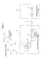
- FIG.1 description will be given on a measuring system which comprises a measuring instrument according to an embodiment of the present invention.
- reference numeral 1 denotes a measuring instrument to be installed in a measurement cabin 9.
- the measuring instrument 1 is provided with a telescope unit 2 and can rotate the telescope unit 2 in horizontal direction and in vertical direction and has an automatic sighting function.
- Reference numeral 3 denotes a measuring instrument PC, and the measuring instrument PC 3 is electrically connected to the measuring instrument 1 or is integrated with the measuring instrument 1 and issues instructions relating to the measurement. Further, the measuring instrument PC 3 accumulates measurement data obtained by the measuring instrument 1 or transmits the measurement data to a base station PC 6.
- Reference numeral 4 denotes a power source, and the power source 4 supplies electric power to the measuring instrument 1 and the measuring instrument PC 3.
- the measuring instrument 1 has a horizontal angle measuring unit 32 (see FIG.3 ) and a vertical angle measuring unit 31 (see FIG.3 ).
- reference numerals 5-1, 5-2, 5-3, ., 5-n each denotes an object to be measured installed at a measuring point.
- a reflective target having retro-reflectivity is used, and further, as a reflection target, a prism, a reflective sheet, or the like are used.
- the base station PC 6 is installed at an administrative office 10 or the like to manage and administer tunnels, dams, etc.
- the base station PC 6 accumulates monitoring data transmitted from the measuring instrument PC 3, compares the received monitoring data with the monitoring data obtained in the past, and judges the present state of tunnels, dams, etc.
- the measuring instrument PC 3 and the base station PC 6 can transmit and receive data communication to and from each other via a communication means 7 as required such as LAN, wireless communication, etc.
- FIG.2 shows an optical system 11 of the measuring instrument 1 and the optical system 11 is designed to have a fixed magnification factor.
- reference numeral 12 denotes an optical axis (visual axis) of the optical system 11
- reference numeral 13 denotes a light source for distance measurement
- reference numeral 14 denotes a light source for sighting
- reference numeral 15 denotes a first light projecting optical system for guiding a distance measuring light from the light source 13 for distance measurement to the optical axis
- reference numeral 16 denotes a second light projecting optical system for guiding a sighting light from the light source 14 for sighting to the optical axis
- reference numeral 17 denotes an objective lens disposed on the optical axis
- reference numeral 18 denotes a focus lens disposed on the optical axis 12
- reference numeral 19 denotes an eye piece.
- the light source 13 for distance measurement is designed to emit a visible light as a distance measuring light, and the light source 14 for sighting emits an invisible light such as infrared light as a sighting light.
- the distance measuring light emitted from the light source 13 for distance measurement and the sighting light emitted from the light source 14 for sighting are projected on the optical axis 12 respectively.
- a reflection light of the distance measuring light (hereinafter referred as a "reflected distance measuring light”) and a reflection light of the sighting light (hereinafter referred as a "reflected sighting light”) enter the objective lens 17 and are converged.
- a dichroic prism 21 On the optical axis 12, a dichroic prism 21 is provided.
- the dichroic prism 21 reflects a reflected sighting light 22 on one reflection surface, and the reflected sighting light 22 is separated by the dichroic prism 21.
- the reflected sighting light 22 thus separated enter an image sensor 23.
- the dichroic prism 21 reflects a reflected distance measuring light 24 on the other reflection surface and the reflected distance measuring light 24 is separated.
- the reflected distance measuring light 24 thus separated enters a photodetection element 25 for distance measurement.
- a natural light 22' passes through the dichroic prism 21, and the natural light 22' after passing through enters the eye piece 19 through the focus lens 18.
- the image sensor 23 is a CCD, a CMOS sensor, etc. for instance, which is an aggregate of pixels, and each pixel is designed so that each pixel can be specified on a light receiving surface (i.e. image pickup surface). Further, the image sensor 23 is so arranged that the center of the image sensor 23 coincide with the optical axis 12.
- a position of each of the pixels is specified by rectangular coordinates, which have the optical axis 12 as the origin.
- a field angle of the predetermined pixel with respect to the optical axis 12 i.e. an angle with respect to the optical axis as obtained from the position of the pixel
- the optical system 11, the image sensor 23, etc. make up together an image pickup unit 26, and the image pickup unit 26 acquires a digital image via the image sensor 23.
- an image of the reflection target 5 is detected from a digital image acquired by the image sensor 23, and based on the image of the reflection target 5, a position of the reflection target 5 on the image is obtained, and from a relative relation between the position and the optical axis 12, a vertical angle and a horizontal angle with respect to the optical axis 12 is obtained. Further, each of a vertical angle and a horizontal angle of the optical axis 12 are measured by the vertical angle measuring unit 31 and the horizontal angle measuring unit 32 respectively, and based on the vertical angle and the horizontal angle of the optical axis 12 and the vertical angle and the horizontal angle in the image sensor 23, it is designed so that a position of the reflection target 5 (i.e. a vertical angle and a horizontal angle) is detected.
- FIG.3 is a block diagram to show an approximate system configuration of the measuring instrument 1.
- reference numeral 27 denotes an arithmetic processing part typically represented by CPU
- reference numeral 28 denotes a storage part
- reference numeral 29 denotes a distance measuring unit
- reference numeral 31 denotes a vertical angle measuring unit
- reference numeral 32 denotes a horizontal angle measuring unit
- reference numeral 33 denotes a communication unit
- reference numeral 34 denotes a display unit
- reference numeral 35 denotes an automatic sighting unit
- reference numeral 36 denotes a vertical motor for rotating the telescope unit 2 in vertical direction
- reference numeral 37 denotes a horizontal motor for rotating the telescope unit 2 in horizontal direction
- reference numeral 38 denotes a vertical motor encoder installed on the vertical motor 36
- reference numeral 39 denotes a horizontal motor encoder installed on the horizontal motor 37
- reference numeral 40 denotes an operation unit.
- the distance measuring unit 29 comprises the light source 13 for distance measurement, the photodetection element 25 for distance measurement, the arithmetic processing part 27, the storage part 28, etc.
- the distance measuring unit 29 performs distance measurement based on a reflected distance measuring light received by the photodetection element 25 for distance measurement.
- the automatic sighting unit 35 comprises the light source 14 for sighting, the image sensor 23, the arithmetic processing part 27, the storage part 28, etc. At the automatic sighting unit 35, the reflected sighting light from the reflection target 5 is received by the image sensor 23. Based on the result of photodetection, an automatic sighting is performed to make the sighting optical axis coincide with the reflection target 5.
- the vertical angle measuring unit 31 measures a vertical angle of the sighting optical axis of the telescope unit 2 and sends the measurement result to the arithmetic processing part 27 as an electric signal.
- the horizontal angle measuring unit 32 has a reference point and measures a horizontal angle of the sighting optical axis with respect to the reference point, and the result of measurement is sent to the arithmetic processing part 27.
- the vertical motor 36 and the horizontal motor 37 are driven and controlled by the arithmetic processing part 27.
- a rotation amount and a rotation speed of the vertical motor 36 are detected by the vertical motor encoder 38 installed on the vertical motor 36, and a rotation amount and a rotation speed of the horizontal motor 37 are detected by the horizontal motor encoder 39 installed on the horizontal motor 37.
- the arithmetic processing part 27 Based on a program (to be described later) stored in the storage part 28, the arithmetic processing part 27 performs image processing, performs distance measurement by driving the distance measuring unit 29, performs automatic sighting by driving the automatic sighting unit 35 and performs three-dimensional measurement for each of the reflection targets 5 respectively based on the measurement results from the distance measuring unit 29, the vertical angle measuring unit 31 and the horizontal angle measuring unit 32. The obtained measurement results are sent to the measuring instrument PC 3.
- various types of programs are stored. These programs include, for instance: a measurement program for making the measuring instrument 1 perform the measuring operation and for acquiring three-dimensional data of the measuring points (i.e. the reflection target 5), or a sequence program for sequentially searching the measuring points and for carrying out operation such as acquisition of images by the image sensor 23, an image processing program for detecting the reflection target image from a digital image acquired by the image sensor 23, a program for detecting a reflection target position on the image by performing image processing on the detected reflection target image, a target position measuring program for obtaining a position (i.e.
- an automatic sighting program for sighting the telescope unit 2 on the reflection target 5 based on the position of the reflection target 5 as measured, or a teaching program for executing a teaching based on the data as measured on each of the reflection targets 5 by executing the automatic sighting program and the measurement program, or a monitoring program for executing the automatic sighting program and the measurement program at a predetermined time interval based on the teaching results, for detecting a position of each measuring point and for storing the detection results in time series at the storage part 28, and other types of programs.
- the measuring instrument 1 executes the teaching or the monitoring and thereby the measuring point data acquired are sent to the measuring instrument PC 3.
- the measuring instrument PC 3 stores the measuring point data in time series interrelating to each of the reflection targets 5 in time series.
- the measuring instrument PC 3 has programs such as a control program for making the measuring instrument 1 carry out the teaching or the monitoring and an abnormality judging program for calculating based on the measurement data as to whether there is a displacement or not and as to the extent of displacement for each of the reflection targets (measuring points) and for judging whether there is any abnormality or not.
- Step 01 A range where a reference point and a measuring point are present (i.e. searching range) is specified.
- the telescope unit 2 is directed toward the position of a starting point and a finishing point for performing the teaching operation, and an angle measurement value at that time are acquired from the vertical angle measuring unit 31 and the horizontal angle measuring unit 32.
- the operator may directly operate the telescope unit 2 or the telescope unit 2 may be moved by remote control from the measuring instrument PC 3.
- the angle measurement value may be directly specified from the operation unit 40 of the measuring instrument 1 or the angle measurement value may be specified by remote control from the measuring instrument PC 3.
- the display unit 34 is a touch panel, the starting point and the finishing point are set up on the display unit 34.
- the starting point position and the finishing point position are not specified, and by rotating the telescope unit 2 over an angle of 360° with respect to the vertical axis, the teaching may be performed over the total circumference. What is important is that the specifying is made for a range a little wider than the range where the reference points and the measuring points are present so that all of the reflection targets 5 can be discovered in a reliable manner.
- Step 02 When the specification of the searching range has been completed, a light amount of the sighting light issued for the purpose of searching is set up.
- the light amount to be set up the light amount is set up so as to detect a sighting light reflected by the reflection target 5 located at the most distant point (e.g. maximum light amount) existing in the searching range. It is to be noted that in the teaching operation, the light amount is set up in advance or may be fixed. In this case, Step 02 is omitted.
- Step 03 Searching is performed according to a scanning pattern as set up in advance.
- the vertical motor 36 and the horizontal motor 37 are driven by using the searching function of the measuring instrument 1.
- the telescope unit 2 is reciprocally scanned at a predetermined speed in horizontal direction, and is rotated at a predetermined speed in vertical direction by a predetermined angle at the horizontal scanning ends.
- the searching range can be scanned without any omissions.
- the predetermined rotation angle in vertical direction is set up to an angle smaller than the view angle in vertical direction of a field of view 42 (see FIG.5 ) of the telescope unit 2 so that the field of view in the upper scanning and the field of view in the lower scanning are overlapped on each other in a range as required.
- Step 04 digital image data are acquired by the image pickup unit 26 at a predetermined time interval, and the acquired digital images are stored in the storage part 28.
- the scanning pattern there are no specific limitations to the scanning pattern, but since the field of view 42 of the telescope unit 2 is in circular shape, in a case where the reflection target 5 is present near an upper or a lower end of the field of view 42 of the telescope unit 2, under a condition where scanning is performed in horizontal direction for instance, the reflection target 5 enters inside the field of view 42 only for a single moment.
- the image of the reflection target 5 cannot be acquired, so, in a case where the scanning is performed in horizontal direction, scanning is performed with a little overlapping in up-to-down direction of the field of view 42 (see FIG.5 ). Similarly, in a case where the scanning is performed in vertical direction, the time interval and the scanning speed to acquire the images are set up so that the images can be acquired with a little overlapping in left-to-right direction of the field of view 42.
- the relation between the scanning speed in the horizontal direction and the time interval of the image acquisition is set up in such manner that at least 2 or more of the same target appear in a plurality of images.
- Step 05 When the image is acquired in Step 04, a horizontal angle and a vertical angle (hereinafter the term “directional angle” is used for both of the horizontal angle and the vertical angle) are measured in synchronization with the acquisition of the image, and the directional angle associated with the acquired image and is stored in the storage part 28.
- a horizontal angle and a vertical angle hereinafter the term “directional angle” is used for both of the horizontal angle and the vertical angle
- Step 06 Image processing is performed on each of the images stored in the storage part 28. It is confirmed whether or not the reflection target image is present or not in the image. Further, from the images including the reflection target image, the reflection target image is detected. Further, a position in the images of the reflection target image in each of the images (i.e. a position on the photodetection surface of the image sensor 23) is obtained.
- Step 07 The procedures in Step 03 to Step 06 is repeated until the scanning with respect to the entire searching range is completed.
- Step 08 Integrated processing is carried out based on an image which include the reflection target image, on a directional angle associated with the image, and on the position of the reflection target image in the image.
- the integrated processing is a processing for measuring a directional angle of an accurate reflection target by giving further consideration to a position of the reflection target image in the image.
- FIG.6A shows a relation between the field of view 42, a photodetecting area 43 and a reflection target image 44 in an image acquired while scanning. Further, FIG.6A shows a case where the same reflection targets 5 are included in three images.
- FIG.6A shows a condition where three images are overlapped with each other with the optical axis as the center.
- a reflection target image 44-1 is included in the image acquired at the time t1 (hereinafter referred as "image t1")
- a reflection target image 44-2 is included in the image acquired at the time t2 (hereinafter referred as "image t2")
- a reflection target image 44-3 is included in the image acquired at time t3 (hereinafter referred as "image t3").
- the reflection target image 44-1 is a perfect image, while the reflection target image 44-2 and the reflection target image 44-3 are respective images which have lacking portions.
- a minimum rectangle surrounding the reflection target image 44 is set up, which is found in the field of view 42 and is included within the photodetection area 43.
- the entire image of the reflection target image 44-1 within the image t1 is included in the image t1 and is an image in perfect circular shape.
- the minimum rectangle 45-1 surrounding the reflection target image 44-1 is in form of a square, which is in contact with the reflection target image 44-1. Further, an area of the rectangle 45-1 at this moment is the largest among the rectangles surrounding the reflection target image. It is to be noted that in a case where the reflection target image 44 is obtained by an ellipse or the like, the rectangle corresponds to a shape of an ellipse.
- a smallest rectangle 45-2 surrounding the reflection target image 44-2 in the image t2 is set up.
- the rectangle 45-2 in this case lacks a right-side portion of the reflection target image 44-2 and is a longitudinal rectangle. Further, coordinates of a diagonal vertex of the rectangle 45-2 are acquired.
- a minimum rectangle 45-3 surrounding the reflection target image 44-3 in the image t3 is set up.
- the reflection target image 44-3 in this case lacks most of its part, and only the right upper portion of the reflection target image 44-3 is a portion where the field of view 42 and the photodetection area 43 are included in common. Accordingly, the rectangle 45-3 is a small rectangle longer in horizontal direction.
- coordinates of a diagonal vertex of the rectangle 45-3 are acquired. The coordinates of a diagonal vertex become a rectangular data showing a position of the rectangle and a size and a shape of the rectangle.
- the horizontal angle and the vertical angle of the optical axis 12 vary corresponding to the times t1, t2 and t3.
- a diagonal vertex of rectangle i.e. coordinates in the photodetection area 43
- absolute coordinates of the diagonal vertex two-dimensional coordinates
- the rectangles are overlapped on each other based on the absolute coordinates.
- the directional angle is measured by the vertical angle measuring unit 31 and the horizontal angle measuring unit 32.
- directions of the optical axis 12 are made to coincide based on the detection results of the vertical angle measuring unit 31 and the horizontal angle measuring unit 32. For instance, three images are made to coincide with the direction of the optical axis 12 acquired at the time t1 and three rectangles 45-1, 45-2 and 45-3 are further overlapped on each other.
- the rectangles 45-1, 45-2 and 45-3 show one portion or all of the reflection target images 44, which naturally overlaps on each other. That is, if even one portion of a plurality of the reflection target images 44 obtained are overlapped on each other, the reflection target images are judged as a reflection target image 44 of the same reflection target 5.
- FIG.6C The aspect of the overlapping of rectangles is shown in FIG.6C . Because the reflection target images 44 acquired are with the same magnification factor and at the same distance, the rectangle 45-1 of a perfect image will be the largest. Further, the rectangles 45-2 and 45-3 are each included in the rectangle 45-1 respectively. A middle point of a 2-point coordinates of diagonal vertexes of the rectangle (rectangle 45-1 in the figure) including all rectangles will be the directional angle of the reflection target 5.
- a central position of the rectangle 45 is the position of the reflection target 5, and a position of the reflection target 5 in the image is converted to an angle (angle of view) having the optical axis 12 as the center. Accordingly, when the angle of view is added to the directional angle associated with the image, an accurate directional angle (composite directional angle) of the reflection target 5 can be obtained.
- the integrated processing as described above is executed with respect to all of the reflection targets 5, and directional angles of all the reflection targets 5 are measured (coarse measurement).
- the results of the coarse measurement are stored in the storage part 28.
- Step 09 and Step 10 Based on directional angle obtained by the coarse measurement, the telescope unit 2 is turned to a direction of the target value in a predetermined order, e.g. in the order of an identification number added to the reflection target 5. Since the directional angle obtained by the coarse measurement as described above is accurate, if the telescope unit 2 is directed based on the directional angle, the optical axis of the telescope unit 2 coincides with the direction of the reflection target 5.
- the reflection target 5 intended as the object is captured by the image sensor 23 via the telescope unit 2, the reflection target 5 in the image of the image sensor 23 is detected, a deviation of the reflection target 5 with respect to the optical axis 12 is obtained, and the vertical motor 36 and the horizontal motor 37 are driven and controlled so that the deviation will be 0.
- the position of the reflection target 5 when obtaining the deviation can be the center of the image of the reflection target 5.
- the optical axis of the telescope unit 2 coincides with the direction of the reflection target 5, and automatic sighting by the telescope unit 2 is carried out in a simple and a quick manner.
- Step 11 When sighting has been completed, distance measurement is carried out by the distance measuring unit 29, and angle measurement of a vertical angle and a horizontal angle are performed by the vertical angle measuring unit 31 and the horizontal angle measuring unit 32. The result of distance measurement and the result of angle measurement are associated with the reflection target
- teaching data may be sent to the measuring instrument PC 3 via the communication unit 33 and may be recorded and stored in the measuring instrument PC 3.
- Step 12 When distance measurement and angle measurement have been carried out for all of the reflection targets 5, the teaching operation is completed, and the teaching data are stored in the storage part 28 or in the measuring instrument PC 3. With the completion of the teaching and the acquisition of the teaching data, it is possible to perform automatic monitoring measurement.
- the measuring instrument PC 3 controls the measuring instrument 1 in such a manner that the measuring instrument 1 performs searching, sighting and distance measuring sequentially of all prisms based on the teaching data at a predetermined time interval, and carries out monitoring measurement.
Abstract
SOLUTION: The scanning operation involves taking overlapping photos in which partial and complete target images are identified and marked using rectangular bounding boxes. These individual boxes are superimposed (if possible) based on their known angular coordinates so as to determine if they belong to the same target reflector, and a center point of an overall bounding box that encloses all individual bounding boxes belonging to a same reflector is selected as the center point of the reflector.
Description
- The present invention relates to a measuring method and a measuring instrument which measures a multiple number of points periodically or continuously over time.
- For the purposes of observing a sinking of ground, of observing a landslide, of observing a displacement of banks and walls of construction work such as a dam, of observing a displacement of wall surface of a tunnel, a multiple number of measuring points set in a measurement range are measured periodically or continuously over time by a measuring instrument.
- For instance, in a case where a tunnel is dug for a construction of an underground railway, for the purpose of observing whether or not the ceiling and the wall surface of the tunnel constructed may not be displaced, a multiple number of prisms are installed as targets on the ceiling and on the wall surface and positional displacement of all the prisms are measured one after another without operator intervention by the measuring instrument (hereinafter referred as "monitoring measurement").
- When the monitoring measurement is performed, the measuring instrument automatically searches the prisms, i.e. the measuring points, performs sighting, measures distances and carries out the measuring operation. In order to acquire initial values to search the measuring points as set up, it is necessary to carry out teaching operations on each of the measuring points.
- In a conventional teaching operation, an operator sights each of the measuring points by a measuring instrument, measures a horizontal angle, vertical angle and distance for each of the measuring points, performs three-dimensional measurement with respect to each of the measuring points and sets the results of measurement thus obtained as initial values of each measuring point respectively. According to this method, the operator measures the measuring points one by one, and further, a view angle of a sighting telescope provided on the measuring instrument is narrow. This means that much time is required for sighting and the working efficiency is low. As a result, much time is required. In particular, in a case where there are restrictions in terms of time for the measuring operation, e.g. in a case where the operation is performed in a tunnel for an underground railway, the measuring operation must be completed during the time period when the underground railway is not in operation in order to perform monitoring measurement on the ceiling and the wall surface of the tunnel, and so the measuring time is required to be shortened.
- In the Japanese Patent Application Publication
JP-A-2012-73201 - In the measuring method and the measuring instrument according to the Japanese Patent Application Publication
JP-A-2012-73201 - It is an object of the present invention to provide a measuring method and a measuring instrument, by which it is possible to measure a coordinate position of the measuring point in the teaching operation with high accuracy.
- To attain the object as described above, a measuring method according to the present invention performs monitoring measurement on two or more objects to be measured by a measuring instrument, which comprises a telescope unit for sighting an object to be measured, a distance measuring unit for projecting a distance measuring light through the telescope unit and for measuring a distance to the object to be measured, an image pickup unit for taking an image in sighting direction and for acquiring a digital image, an angle detecting unit for detecting a directional angle in the sighting direction of the telescope unit, and an automatic sighting unit for making the telescope unit perform an automatic sighting to the object to be measured, comprising a step of rotating the telescope unit in horizontal direction and in vertical direction and of scanning a predetermined range being set up so as to include two or more objects to be measured, a step of acquiring digital images at a predetermined time interval so that there are two or more images which include the same object to be measured while scanning, a step of detecting an image of the object to be measured in the digital image and of setting up a minimal rectangle surrounding the image of the object to be measured, a step of overlapping the minimal rectangles obtained in two or more digital images and of carrying out integrated processing to obtain positions of the objects to be measured in the image, a coarse measurement step of calculating a composite directional angle of each of the objects to be measured respectively based on a position in the image obtained by integrated processing and on a directional angle of a sighting axis, and a step of associating the composite directional angle obtained by the coarse measurement with each of the objects to be measured and of storing the composite directional angle as target values for automatic sighting.
- Further, the measuring method according to the present invention further comprises a precise measurement step of making the telescope unit perform an automatic sighting on the objects to be measured one after another based on the stored composite directional angle and of performing distance measurement and angle measurement, and a step of associating the measurement results obtained in the precise measurement with the objects to be measured and of acquiring the measurement results as initial values.
- Further, a measuring instrument according to the present invention comprises a telescope unit for sighting an object to be measured, a distance measuring unit for measuring a distance to the object to be measured by projecting a distance measuring light through the telescope unit, an image pickup unit for taking an image in sighting direction and for acquiring a digital image, an angle detecting unit for detecting a directional angle in the sighting direction of the telescope unit, an automatic sighting unit for making the telescope unit perform an automatic sighting to the object to be measured, an arithmetic processing part and a storage part, wherein the arithmetic processing part makes the telescope unit rotate in horizontal direction and in vertical direction and perform scanning over a predetermined range so as to include two or more objects to be measured, and while scanning by the image pickup unit, acquires digital images at a predetermined time interval so that there will be two or more images which include the same object to be measured, detects images of objects to be measured in the digital images, sets up a minimal rectangle surrounding the images of the objects to be measured, overlaps the minimal rectangle obtained in two or more digital images and carries out integrated processing to obtain positions of the objects to be measured in the image and calculates a composite directional angle of each of the objects to be measured respectively based on a position in the image obtained by integrated processing and on a directional angle of a sighting axis and associates a composite directional angle of the object to be measured to the object to be measured and stores to the storage part as a target value for automatic sighting.
- Furthermore, in the measuring instrument according to the present invention, the arithmetic processing part makes the automatic sighting unit perform an automatic sighting of the telescope unit sequentially on the objects to be measured based on the target values stored in the storage part, executes precise measurement for distance measurement and angle measurement, associates the measurement results obtained by the precise measurement with the objects to be measured and acquires the measurement results as initial values.
- According to the present invention, the measuring method performs monitoring measurement on two or more objects to be measured by a measuring instrument, which comprises a telescope unit for sighting an object to be measured, a distance measuring unit for projecting a distance measuring light through the telescope unit and for measuring a distance to the object to be measured, an image pickup unit for taking an image in sighting direction and for acquiring a digital image, an angle detecting unit for detecting a directional angle in the sighting direction of the telescope unit, and an automatic sighting unit for making the telescope unit perform an automatic sighting to the object to be measured, comprising a step of rotating the telescope unit in horizontal direction and in vertical direction and of scanning a predetermined range being set up so as to include two or more objects to be measured, a step of acquiring digital images at a predetermined time interval so that there are two or more images which include the same object to be measured while scanning, a step of detecting an image of the object to be measured in the digital image and of setting up a minimal rectangle surrounding the image of the object to be measured, a step of overlapping the minimal rectangles obtained in two or more digital images and of carrying out integrated processing to obtain positions of the objects to be measured in the image, a coarse measurement step of calculating a composite directional angle of each of the objects to be measured respectively based on a position in the image obtained by integrated processing and on a directional angle of a sighting axis, and a step of associating the composite directional angle obtained by the coarse measurement with each of the objects to be measured and of storing the composite directional angle as target values for automatic sighting. As a result, there is no need for the operator to perform sighting for each of the objects to be measured in a teaching operation, and it is possible to automate the sighting on a plurality of objects to be measured, and further, the images of the objects to be measured can be accurately specified and the directional angle of the object to be measured can be measured in a reliable manner.
- Further, according to the present invention, the measuring method further comprises a precise measurement step of making the telescope unit perform an automatic sighting on the objects to be measured one after another based on the stored composite directional angle and of performing distance measurement and angle measurement, and a step of associating the measurement results obtained in the precise measurement with the objects to be measured and of acquiring the measurement results as initial values. As a result, it is possible to omit a searching operation for the detection of the object to be measured when performing a precise measurement by automatically sighting a plurality of objects to be measured, which extensively shortens the time for performing a precise measurement of a plurality of objects to be measured.
- Further, according to the present invention, the measuring instrument comprises a telescope unit for sighting an object to be measured, a distance measuring unit for measuring a distance to the object to be measured by projecting a distance measuring light through the telescope unit, an image pickup unit for taking an image in sighting direction and for acquiring a digital image, an angle detecting unit for detecting a directional angle in the sighting direction of the telescope unit, an automatic sighting unit for making the telescope unit perform an automatic sighting to the object to be measured, an arithmetic processing part and a storage part, wherein the arithmetic processing part makes the telescope unit rotate in horizontal direction and in vertical direction and perform scanning over a predetermined range so as to include two or more objects to be measured, and while scanning by the image pickup unit, acquires digital images at a predetermined time interval so that there will be two or more images which include the same object to be measured, detects images of objects to be measured in the digital images, sets up a minimal rectangle surrounding the images of the objects to be measured, overlaps the minimal rectangle obtained in two or more digital images and carries out integrated processing to obtain positions of the objects to be measured in the image and calculates a composite directional angle of each of the objects to be measured respectively based on a position in the image obtained by integrated processing and on a directional angle of a sighting axis and associates a composite directional angle of the object to be measured to the object to be measured and stores to the storage part as a target value for automatic sighting. As a result, there is no need for the operator to perform sighting for each of the objects to be measured, it is possible to automate the sighting on a plurality of objects to be measured, and further, the images of the objects to be measured can be accurately specified and the directional angle of the object to be measured can be measured in a reliable manner.
- Furthermore, according to the present invention, in the measuring instrument, the arithmetic processing part makes the automatic sighting unit perform an automatic sighting of the telescope unit sequentially on the objects to be measured based on the target values stored in the storage part, executes precise measurement for distance measurement and angle measurement, associates the measurement results obtained by the precise measurement with the objects to be measured and acquires the measurement results as initial values. As a result, it is possible to set up an initial value in an efficient manner in a case where the monitoring measurement is to be performed.
-
-
FIG.1 is a drawing to show system configuration, which includes a measuring instrument according to an embodiment of the present invention. -
FIG.2 is a system diagram of an optical system provided on the measuring instrument. -
FIG.3 is a schematical block diagram of the measuring instrument. -
FIG.4 is a flowchart of an embodiment of the present invention. -
FIG.5 is an explanatory drawing to show a relation between a scanning locus, a field of view of a telescope unit and a reflection target in the present embodiment. -
FIG.6A is a drawing to show a relation between a field of view, a photodetecting area and a reflection target image in an image acquired while scanning,FIG.6B is an explanatory drawing to show an image processing for measuring a position of a reflection target image, andFIG.6C is an explanatory drawing of an integrating operation of a rectangular data acquired in the image processing. - Description will be given below on an embodiment of the present invention by referring to the attached drawings.
- First, referring to
FIG.1 , description will be given on a measuring system which comprises a measuring instrument according to an embodiment of the present invention. - In
FIG.1 ,reference numeral 1 denotes a measuring instrument to be installed in ameasurement cabin 9. Themeasuring instrument 1 is provided with a telescope unit 2 and can rotate the telescope unit 2 in horizontal direction and in vertical direction and has an automatic sighting function.Reference numeral 3 denotes a measuring instrument PC, and themeasuring instrument PC 3 is electrically connected to themeasuring instrument 1 or is integrated with themeasuring instrument 1 and issues instructions relating to the measurement. Further, themeasuring instrument PC 3 accumulates measurement data obtained by themeasuring instrument 1 or transmits the measurement data to a base station PC 6.Reference numeral 4 denotes a power source, and thepower source 4 supplies electric power to themeasuring instrument 1 and the measuring instrument PC 3. It is to be noted that although not shown in the figure, themeasuring instrument 1 has a horizontal angle measuring unit 32 (seeFIG.3 ) and a vertical angle measuring unit 31 (seeFIG.3 ). Further, reference numerals 5-1, 5-2, 5-3, ....., 5-n each denotes an object to be measured installed at a measuring point. It is to be noted that as the object to be measured, a reflective target having retro-reflectivity is used, and further, as a reflection target, a prism, a reflective sheet, or the like are used. - The base station PC 6 is installed at an
administrative office 10 or the like to manage and administer tunnels, dams, etc. The base station PC 6 accumulates monitoring data transmitted from the measuring instrument PC 3, compares the received monitoring data with the monitoring data obtained in the past, and judges the present state of tunnels, dams, etc. - The measuring instrument PC 3 and the base station PC 6 can transmit and receive data communication to and from each other via a communication means 7 as required such as LAN, wireless communication, etc.
-
FIG.2 shows anoptical system 11 of themeasuring instrument 1 and theoptical system 11 is designed to have a fixed magnification factor. InFIG.2 ,reference numeral 12 denotes an optical axis (visual axis) of theoptical system 11,reference numeral 13 denotes a light source for distance measurement,reference numeral 14 denotes a light source for sighting,reference numeral 15 denotes a first light projecting optical system for guiding a distance measuring light from thelight source 13 for distance measurement to theoptical axis 12,reference numeral 16 denotes a second light projecting optical system for guiding a sighting light from thelight source 14 for sighting to theoptical axis 12,reference numeral 17 denotes an objective lens disposed on theoptical axis 12,reference numeral 18 denotes a focus lens disposed on theoptical axis 12, andreference numeral 19 denotes an eye piece. - The
light source 13 for distance measurement is designed to emit a visible light as a distance measuring light, and thelight source 14 for sighting emits an invisible light such as infrared light as a sighting light. The distance measuring light emitted from thelight source 13 for distance measurement and the sighting light emitted from thelight source 14 for sighting are projected on theoptical axis 12 respectively. A reflection light of the distance measuring light (hereinafter referred as a "reflected distance measuring light") and a reflection light of the sighting light (hereinafter referred as a "reflected sighting light") enter theobjective lens 17 and are converged. - On the
optical axis 12, adichroic prism 21 is provided. Thedichroic prism 21 reflects areflected sighting light 22 on one reflection surface, and thereflected sighting light 22 is separated by thedichroic prism 21. Thereflected sighting light 22 thus separated enter animage sensor 23. - Further, the
dichroic prism 21 reflects a reflecteddistance measuring light 24 on the other reflection surface and the reflecteddistance measuring light 24 is separated. The reflecteddistance measuring light 24 thus separated enters aphotodetection element 25 for distance measurement. A natural light 22' passes through thedichroic prism 21, and the natural light 22' after passing through enters theeye piece 19 through thefocus lens 18. - The
image sensor 23 is a CCD, a CMOS sensor, etc. for instance, which is an aggregate of pixels, and each pixel is designed so that each pixel can be specified on a light receiving surface (i.e. image pickup surface). Further, theimage sensor 23 is so arranged that the center of theimage sensor 23 coincide with theoptical axis 12. - Further, a position of each of the pixels is specified by rectangular coordinates, which have the
optical axis 12 as the origin. By obtaining the position of a predetermined pixel (coordinates) on theimage sensor 23, a field angle of the predetermined pixel with respect to the optical axis 12 (i.e. an angle with respect to the optical axis as obtained from the position of the pixel) can be acquired. Theoptical system 11, theimage sensor 23, etc. make up together animage pickup unit 26, and theimage pickup unit 26 acquires a digital image via theimage sensor 23. - In the present embodiment, an image of the
reflection target 5 is detected from a digital image acquired by theimage sensor 23, and based on the image of thereflection target 5, a position of thereflection target 5 on the image is obtained, and from a relative relation between the position and theoptical axis 12, a vertical angle and a horizontal angle with respect to theoptical axis 12 is obtained. Further, each of a vertical angle and a horizontal angle of theoptical axis 12 are measured by the verticalangle measuring unit 31 and the horizontalangle measuring unit 32 respectively, and based on the vertical angle and the horizontal angle of theoptical axis 12 and the vertical angle and the horizontal angle in theimage sensor 23, it is designed so that a position of the reflection target 5 (i.e. a vertical angle and a horizontal angle) is detected. -
FIG.3 is a block diagram to show an approximate system configuration of the measuringinstrument 1. InFIG.3 ,reference numeral 27 denotes an arithmetic processing part typically represented by CPU,reference numeral 28 denotes a storage part,reference numeral 29 denotes a distance measuring unit,reference numeral 31 denotes a vertical angle measuring unit,reference numeral 32 denotes a horizontal angle measuring unit,reference numeral 33 denotes a communication unit,reference numeral 34 denotes a display unit,reference numeral 35 denotes an automatic sighting unit,reference numeral 36 denotes a vertical motor for rotating the telescope unit 2 in vertical direction,reference numeral 37 denotes a horizontal motor for rotating the telescope unit 2 in horizontal direction,reference numeral 38 denotes a vertical motor encoder installed on thevertical motor 36,reference numeral 39 denotes a horizontal motor encoder installed on thehorizontal motor 37, andreference numeral 40 denotes an operation unit. - The
distance measuring unit 29 comprises thelight source 13 for distance measurement, thephotodetection element 25 for distance measurement, thearithmetic processing part 27, thestorage part 28, etc. Thedistance measuring unit 29 performs distance measurement based on a reflected distance measuring light received by thephotodetection element 25 for distance measurement. - The
automatic sighting unit 35 comprises thelight source 14 for sighting, theimage sensor 23, thearithmetic processing part 27, thestorage part 28, etc. At theautomatic sighting unit 35, the reflected sighting light from thereflection target 5 is received by theimage sensor 23. Based on the result of photodetection, an automatic sighting is performed to make the sighting optical axis coincide with thereflection target 5. - The vertical
angle measuring unit 31 measures a vertical angle of the sighting optical axis of the telescope unit 2 and sends the measurement result to thearithmetic processing part 27 as an electric signal. The horizontalangle measuring unit 32 has a reference point and measures a horizontal angle of the sighting optical axis with respect to the reference point, and the result of measurement is sent to thearithmetic processing part 27. - The
vertical motor 36 and thehorizontal motor 37 are driven and controlled by thearithmetic processing part 27. A rotation amount and a rotation speed of thevertical motor 36 are detected by thevertical motor encoder 38 installed on thevertical motor 36, and a rotation amount and a rotation speed of thehorizontal motor 37 are detected by thehorizontal motor encoder 39 installed on thehorizontal motor 37. - Based on a program (to be described later) stored in the
storage part 28, thearithmetic processing part 27 performs image processing, performs distance measurement by driving thedistance measuring unit 29, performs automatic sighting by driving theautomatic sighting unit 35 and performs three-dimensional measurement for each of the reflection targets 5 respectively based on the measurement results from thedistance measuring unit 29, the verticalangle measuring unit 31 and the horizontalangle measuring unit 32. The obtained measurement results are sent to the measuringinstrument PC 3. - In the
storage part 28, various types of programs are stored. These programs include, for instance: a measurement program for making the measuring instrument 1 perform the measuring operation and for acquiring three-dimensional data of the measuring points (i.e. the reflection target 5), or a sequence program for sequentially searching the measuring points and for carrying out operation such as acquisition of images by the image sensor 23, an image processing program for detecting the reflection target image from a digital image acquired by the image sensor 23, a program for detecting a reflection target position on the image by performing image processing on the detected reflection target image, a target position measuring program for obtaining a position (i.e. a horizontal angle and a vertical angle) of the reflection target 5 based on the reflection target position on the image, an automatic sighting program for sighting the telescope unit 2 on the reflection target 5 based on the position of the reflection target 5 as measured, or a teaching program for executing a teaching based on the data as measured on each of the reflection targets 5 by executing the automatic sighting program and the measurement program, or a monitoring program for executing the automatic sighting program and the measurement program at a predetermined time interval based on the teaching results, for detecting a position of each measuring point and for storing the detection results in time series at the storage part 28, and other types of programs. - Next, description will be given on the measuring
instrument PC 3. - The measuring
instrument 1 executes the teaching or the monitoring and thereby the measuring point data acquired are sent to the measuringinstrument PC 3. The measuringinstrument PC 3 stores the measuring point data in time series interrelating to each of the reflection targets 5 in time series. - Further, the measuring
instrument PC 3 has programs such as a control program for making the measuringinstrument 1 carry out the teaching or the monitoring and an abnormality judging program for calculating based on the measurement data as to whether there is a displacement or not and as to the extent of displacement for each of the reflection targets (measuring points) and for judging whether there is any abnormality or not. - By referring to
FIG.4 , description will be given on the teaching operation of the present embodiment. - (Step 01) A range where a reference point and a measuring point are present (i.e. searching range) is specified. As an actual method for specifying the range, as an example, the telescope unit 2 is directed toward the position of a starting point and a finishing point for performing the teaching operation, and an angle measurement value at that time are acquired from the vertical
angle measuring unit 31 and the horizontalangle measuring unit 32. To direct the telescope unit 2 toward positions of the starting point and the finishing point where the teaching operation is carried out, the operator may directly operate the telescope unit 2 or the telescope unit 2 may be moved by remote control from the measuringinstrument PC 3. Or, the angle measurement value may be directly specified from theoperation unit 40 of the measuringinstrument 1 or the angle measurement value may be specified by remote control from the measuringinstrument PC 3. In a case where thedisplay unit 34 is a touch panel, the starting point and the finishing point are set up on thedisplay unit 34. - In a case where the reference points and the measuring points are present over a total circumference, or are present in a wide range, the starting point position and the finishing point position are not specified, and by rotating the telescope unit 2 over an angle of 360° with respect to the vertical axis, the teaching may be performed over the total circumference. What is important is that the specifying is made for a range a little wider than the range where the reference points and the measuring points are present so that all of the reflection targets 5 can be discovered in a reliable manner.
- (Step 02) When the specification of the searching range has been completed, a light amount of the sighting light issued for the purpose of searching is set up. As the light amount to be set up, the light amount is set up so as to detect a sighting light reflected by the
reflection target 5 located at the most distant point (e.g. maximum light amount) existing in the searching range. It is to be noted that in the teaching operation, the light amount is set up in advance or may be fixed. In this case,Step 02 is omitted. - (Step 03) Searching is performed according to a scanning pattern as set up in advance.
- For the searching, the
vertical motor 36 and thehorizontal motor 37 are driven by using the searching function of the measuringinstrument 1. The telescope unit 2 is reciprocally scanned at a predetermined speed in horizontal direction, and is rotated at a predetermined speed in vertical direction by a predetermined angle at the horizontal scanning ends. By the reciprocal scanning in horizontal direction and the rotation in vertical direction at the horizontal scanning ends, the searching range can be scanned without any omissions. At this time, the predetermined rotation angle in vertical direction is set up to an angle smaller than the view angle in vertical direction of a field of view 42 (seeFIG.5 ) of the telescope unit 2 so that the field of view in the upper scanning and the field of view in the lower scanning are overlapped on each other in a range as required. - (Step 04) During the scanning process, digital image data are acquired by the
image pickup unit 26 at a predetermined time interval, and the acquired digital images are stored in thestorage part 28. There are no specific limitations to the scanning pattern, but since the field ofview 42 of the telescope unit 2 is in circular shape, in a case where thereflection target 5 is present near an upper or a lower end of the field ofview 42 of the telescope unit 2, under a condition where scanning is performed in horizontal direction for instance, thereflection target 5 enters inside the field ofview 42 only for a single moment. For this reason, there may be possibilities that the image of thereflection target 5 cannot be acquired, so, in a case where the scanning is performed in horizontal direction, scanning is performed with a little overlapping in up-to-down direction of the field of view 42 (seeFIG.5 ). Similarly, in a case where the scanning is performed in vertical direction, the time interval and the scanning speed to acquire the images are set up so that the images can be acquired with a little overlapping in left-to-right direction of the field ofview 42. - Further, the relation between the scanning speed in the horizontal direction and the time interval of the image acquisition is set up in such manner that at least 2 or more of the same target appear in a plurality of images.
- (Step 05) When the image is acquired in
Step 04, a horizontal angle and a vertical angle (hereinafter the term "directional angle" is used for both of the horizontal angle and the vertical angle) are measured in synchronization with the acquisition of the image, and the directional angle associated with the acquired image and is stored in thestorage part 28. - (Step 06) Image processing is performed on each of the images stored in the
storage part 28. It is confirmed whether or not the reflection target image is present or not in the image. Further, from the images including the reflection target image, the reflection target image is detected. Further, a position in the images of the reflection target image in each of the images (i.e. a position on the photodetection surface of the image sensor 23) is obtained. - (Step 07) The procedures in
Step 03 to Step 06 is repeated until the scanning with respect to the entire searching range is completed. - (Step 08) Integrated processing is carried out based on an image which include the reflection target image, on a directional angle associated with the image, and on the position of the reflection target image in the image.
- The integrated processing is a processing for measuring a directional angle of an accurate reflection target by giving further consideration to a position of the reflection target image in the image.
- By referring to
FIG.6A to FIG.6C , description will be given below on the integrated processing. - First, description will be given on image processing and on obtaining of the position of the reflection target image in the image.
FIG.6A shows a relation between the field ofview 42, aphotodetecting area 43 and a reflection target image 44 in an image acquired while scanning. Further,FIG.6A shows a case where the same reflection targets 5 are included in three images. - It is to be noted that in
FIG.6A , three of the reflection target images 44 in one image are shown, but in fact, one of the reflection target images 44 is included in one image.FIG.6A shows a condition where three images are overlapped with each other with the optical axis as the center. - Images are acquired at each of the times t1, t2 and t3 respectively. A reflection target image 44-1 is included in the image acquired at the time t1 (hereinafter referred as "image t1"), a reflection target image 44-2 is included in the image acquired at the time t2 (hereinafter referred as "image t2") and a reflection target image 44-3 is included in the image acquired at time t3 (hereinafter referred as "image t3").
- Due to the timing of the photographing, the reflection target image 44-1 is a perfect image, while the reflection target image 44-2 and the reflection target image 44-3 are respective images which have lacking portions.
- As shown in
FIG.6B , for each image, a minimum rectangle surrounding the reflection target image 44 is set up, which is found in the field ofview 42 and is included within thephotodetection area 43. According to an example ofFIG.6B , the entire image of the reflection target image 44-1 within the image t1 is included in the image t1 and is an image in perfect circular shape. The minimum rectangle 45-1 surrounding the reflection target image 44-1 is in form of a square, which is in contact with the reflection target image 44-1. Further, an area of the rectangle 45-1 at this moment is the largest among the rectangles surrounding the reflection target image. It is to be noted that in a case where the reflection target image 44 is obtained by an ellipse or the like, the rectangle corresponds to a shape of an ellipse. - Further, when the rectangle 45-1 is obtained, coordinates t1 (x1, y1) and t1' (x2, y2) at positions of diagonal vertexes of the rectangle 45-1 are obtained. The coordinates in this case become coordinates within the
photodetection area 43 having theoptical axis 12 as an origin. - Similarly, a smallest rectangle 45-2 surrounding the reflection target image 44-2 in the image t2 is set up. The rectangle 45-2 in this case lacks a right-side portion of the reflection target image 44-2 and is a longitudinal rectangle. Further, coordinates of a diagonal vertex of the rectangle 45-2 are acquired.
- Further, a minimum rectangle 45-3 surrounding the reflection target image 44-3 in the image t3 is set up. The reflection target image 44-3 in this case lacks most of its part, and only the right upper portion of the reflection target image 44-3 is a portion where the field of
view 42 and thephotodetection area 43 are included in common. Accordingly, the rectangle 45-3 is a small rectangle longer in horizontal direction. Similarly, coordinates of a diagonal vertex of the rectangle 45-3 are acquired. The coordinates of a diagonal vertex become a rectangular data showing a position of the rectangle and a size and a shape of the rectangle. - It is to be noted that which of the sets is to be chosen among the two sets of coordinates of a diagonal vertex is selected adequately, depending on the condition of the reflection target image 44. What is important is that the rectangular data can be acquired.
- For the
same reflection target 5, three images have been acquired and coordinates in each of the images have been acquired. - Since the three images have been acquired at the times t1, t2 and t3, the horizontal angle and the vertical angle of the
optical axis 12 vary corresponding to the times t1, t2 and t3. From coordinates of a diagonal vertex of rectangle (i.e. coordinates in the photodetection area 43) acquired from the reflection target images 44-1, 44-2 and 44-3 and from directional angles (horizontal angle and vertical angle) of theoptical axis 12 of each image, absolute coordinates of the diagonal vertex (two-dimensional coordinates) are obtained, and the rectangles are overlapped on each other based on the absolute coordinates. It is to be noted that the directional angle is measured by the verticalangle measuring unit 31 and the horizontalangle measuring unit 32. - Or, directions of the
optical axis 12 are made to coincide based on the detection results of the verticalangle measuring unit 31 and the horizontalangle measuring unit 32. For instance, three images are made to coincide with the direction of theoptical axis 12 acquired at the time t1 and three rectangles 45-1, 45-2 and 45-3 are further overlapped on each other. - If the reflection target image 44 is obtained with respect to the
same reflection target 5, the rectangles 45-1, 45-2 and 45-3 show one portion or all of the reflection target images 44, which naturally overlaps on each other. That is, if even one portion of a plurality of the reflection target images 44 obtained are overlapped on each other, the reflection target images are judged as a reflection target image 44 of thesame reflection target 5. - The aspect of the overlapping of rectangles is shown in
FIG.6C . Because the reflection target images 44 acquired are with the same magnification factor and at the same distance, the rectangle 45-1 of a perfect image will be the largest. Further, the rectangles 45-2 and 45-3 are each included in the rectangle 45-1 respectively. A middle point of a 2-point coordinates of diagonal vertexes of the rectangle (rectangle 45-1 in the figure) including all rectangles will be the directional angle of thereflection target 5. - It is to be noted that in a case where a perfect image of the
reflection target 5 cannot be obtained, if the minimum square including an obtainable plurality of rectangles 45 is acquired, the square is regarded as a rectangle surrounding a perfect image. - A central position of the rectangle 45 is the position of the
reflection target 5, and a position of thereflection target 5 in the image is converted to an angle (angle of view) having theoptical axis 12 as the center. Accordingly, when the angle of view is added to the directional angle associated with the image, an accurate directional angle (composite directional angle) of thereflection target 5 can be obtained. - The integrated processing as described above is executed with respect to all of the reflection targets 5, and directional angles of all the reflection targets 5 are measured (coarse measurement). The results of the coarse measurement are stored in the
storage part 28. - When measurement (coarse measurement) of directional angles for all of the reflection targets 5 has been completed, three-dimensional measurement (precise measurement) is started for each of the
individual reflection targets 5 based on the results of angle measurement (target values) of the reflection targets 5. - (
Step 09 and Step 10) Based on directional angle obtained by the coarse measurement, the telescope unit 2 is turned to a direction of the target value in a predetermined order, e.g. in the order of an identification number added to thereflection target 5. Since the directional angle obtained by the coarse measurement as described above is accurate, if the telescope unit 2 is directed based on the directional angle, the optical axis of the telescope unit 2 coincides with the direction of thereflection target 5. - When the setting of the direction of the telescope unit 2 is completed based on the directional angle of the coarse measurement, an automatic sighting is carried out.
- The
reflection target 5 intended as the object is captured by theimage sensor 23 via the telescope unit 2, thereflection target 5 in the image of theimage sensor 23 is detected, a deviation of thereflection target 5 with respect to theoptical axis 12 is obtained, and thevertical motor 36 and thehorizontal motor 37 are driven and controlled so that the deviation will be 0. The position of thereflection target 5 when obtaining the deviation can be the center of the image of thereflection target 5. - As described above, the optical axis of the telescope unit 2 coincides with the direction of the
reflection target 5, and automatic sighting by the telescope unit 2 is carried out in a simple and a quick manner. - (Step 11) When sighting has been completed, distance measurement is carried out by the
distance measuring unit 29, and angle measurement of a vertical angle and a horizontal angle are performed by the verticalangle measuring unit 31 and the horizontalangle measuring unit 32. The result of distance measurement and the result of angle measurement are associated with the reflection target - 5 as teaching data, and also associated with the time of measurement and are recorded and stored in the
storage part 28. It is to be noted that the teaching data may be sent to the measuringinstrument PC 3 via thecommunication unit 33 and may be recorded and stored in the measuringinstrument PC 3. - (Step 12) When distance measurement and angle measurement have been carried out for all of the reflection targets 5, the teaching operation is completed, and the teaching data are stored in the
storage part 28 or in the measuringinstrument PC 3. With the completion of the teaching and the acquisition of the teaching data, it is possible to perform automatic monitoring measurement. - The measuring
instrument PC 3 controls the measuringinstrument 1 in such a manner that the measuringinstrument 1 performs searching, sighting and distance measuring sequentially of all prisms based on the teaching data at a predetermined time interval, and carries out monitoring measurement.
Claims (4)
- A measuring method for performing monitoring measurement on two or more objects to be measured by a measuring instrument (1), which comprises a telescope unit (2) for sighting an object to be measured, a distance measuring unit (29) for projecting a distance measuring light through said telescope unit and for measuring a distance to said object to be measured, an image pickup unit (26) for taking an image in sighting direction and for acquiring a digital image, an angle detecting unit (31, 32) for detecting a directional angle in the sighting direction of said telescope unit, and an automatic sighting unit (35) for making said telescope unit perform an automatic sighting to said object to be measured, comprising a step of rotating said telescope unit in horizontal direction and in vertical direction and of scanning a predetermined range being set up so as to include two or more objects to be measured, a step of acquiring digital images at a predetermined time interval so that there are two or more images which include the same object to be measured while scanning, a step of detecting an image of the object to be measured in said digital image and of setting up a minimal rectangle (45) surrounding the image of the object to be measured, a step of overlapping said minimal rectangles obtained in two or more digital images and of carrying out integrated processing to obtain positions of said objects to be measured in the image, a coarse measurement step of calculating a composite directional angle of each of the objects to be measured respectively based on a position in the image obtained by integrated processing and on a directional angle of a sighting axis, and a step of associating said composite directional angle obtained by said coarse measurement with each of the objects to be measured and of storing said composite directional angle as target values for automatic sighting.
- The measuring method according to claim 1, further comprising a precise measurement step of making said telescope unit (2) perform an automatic sighting on said objects to be measured one after another based on said stored composite directional angle and of performing distance measurement and angle measurement, and a step of associating the measurement results obtained in the precise measurement with said objects to be measured and of acquiring the measurement results as initial values.
- A measuring instrument (1), comprising a telescope unit (2) for sighting an object to be measured, a distance measuring unit (29) for measuring a distance to said object to be measured by projecting a distance measuring light through said telescope unit, an image pickup unit (26) for taking an image in sighting direction and for acquiring a digital image, an angle detecting unit (31, 32) for detecting a directional angle in the sighting direction of said telescope unit, an automatic sighting unit (35) for making said telescope unit perform an automatic sighting to said object to be measured, an arithmetic processing part (27) and a storage part (28), wherein said arithmetic processing part makes said telescope unit rotate in horizontal direction and in vertical direction and perform scanning over a predetermined range so as to include two or more objects to be measured, and while scanning by said image pickup unit, acquires digital images at a predetermined time interval so that there will be two or more images which include the same object to be measured, detects images of objects to be measured in said digital images, sets up a minimal rectangle (45) surrounding the images of the objects to be measured, overlaps said minimal rectangle obtained in two or more digital images and carries out integrated processing to obtain positions of said objects to be measured in the image and calculates a composite directional angle of each of the objects to be measured respectively based on a position in the image obtained by integrated processing and on a directional angle of a sighting axis and associates a composite directional angle of said object to be measured to said object to be measured and stores to said storage part as a target value for automatic sighting.
- The measuring instrument according to claim 3, wherein said arithmetic processing part (27) makes said automatic sighting unit (35) perform an automatic sighting of said telescope unit (2) sequentially on said objects to be measured based on said target values stored in said storage part (28), executes precise measurement for distance measurement and angle measurement, associates the measurement results obtained by said precise measurement with said objects to be measured and acquires the measurement results as initial values.
Applications Claiming Priority (1)
| Application Number | Priority Date | Filing Date | Title |
|---|---|---|---|
| JP2013206664A JP6211876B2 (en) | 2013-10-01 | 2013-10-01 | Measuring method and measuring device |
Publications (2)
| Publication Number | Publication Date |
|---|---|
| EP2863174A1 true EP2863174A1 (en) | 2015-04-22 |
| EP2863174B1 EP2863174B1 (en) | 2016-09-21 |
Family
ID=51655598
Family Applications (1)
| Application Number | Title | Priority Date | Filing Date |
|---|---|---|---|
| EP14187172.3A Active EP2863174B1 (en) | 2013-10-01 | 2014-09-30 | Measuring method and measuring instrument |
Country Status (4)
| Country | Link |
|---|---|
| US (1) | US9719781B2 (en) |
| EP (1) | EP2863174B1 (en) |
| JP (1) | JP6211876B2 (en) |
| CN (1) | CN104515514B (en) |
Families Citing this family (18)
| Publication number | Priority date | Publication date | Assignee | Title |
|---|---|---|---|---|
| US9797719B2 (en) | 2013-10-01 | 2017-10-24 | Kabushiki Kaisha Topcon | Measuring method and measuring instrument |
| JP6436695B2 (en) * | 2014-09-17 | 2018-12-12 | 株式会社トプコン | Surveying device and installation method of surveying device |
| CN105066963A (en) * | 2015-07-23 | 2015-11-18 | 上海应用技术学院 | Visual sense detection apparatus for nail protruding from wood pallet |
| FR3044101B1 (en) * | 2015-11-20 | 2020-04-24 | Thales | PROCESS FOR ACQUIRING IMAGES OF A SCENE FROM A SENSOR ON BOARD A MOVING CARRIER, WITH CONTROL OF ITS SIGHT LINE |
| US10337860B2 (en) * | 2016-12-07 | 2019-07-02 | Magik Eye Inc. | Distance sensor including adjustable focus imaging sensor |
| JP6944790B2 (en) * | 2017-02-22 | 2021-10-06 | 株式会社トプコン | Controls, optics, control methods, unmanned aerial vehicle tracking systems and programs |
| JP2020537237A (en) | 2017-10-08 | 2020-12-17 | マジック アイ インコーポレイテッド | Distance measurement using vertical grid pattern |
| US10931883B2 (en) | 2018-03-20 | 2021-02-23 | Magik Eye Inc. | Adjusting camera exposure for three-dimensional depth sensing and two-dimensional imaging |
| WO2019236563A1 (en) | 2018-06-06 | 2019-12-12 | Magik Eye Inc. | Distance measurement using high density projection patterns |
| WO2020033169A1 (en) | 2018-08-07 | 2020-02-13 | Magik Eye Inc. | Baffles for three-dimensional sensors having spherical fields of view |
| EP3640677B1 (en) | 2018-10-17 | 2023-08-02 | Trimble Jena GmbH | Tracker of a surveying apparatus for tracking a target |
| EP3640590B1 (en) | 2018-10-17 | 2021-12-01 | Trimble Jena GmbH | Surveying apparatus for surveying an object |
| EP3911920A4 (en) | 2019-01-20 | 2022-10-19 | Magik Eye Inc. | Three-dimensional sensor including bandpass filter having multiple passbands |
| EP3696498A1 (en) | 2019-02-15 | 2020-08-19 | Trimble Jena GmbH | Surveying instrument and method of calibrating a survey instrument |
| US11474209B2 (en) | 2019-03-25 | 2022-10-18 | Magik Eye Inc. | Distance measurement using high density projection patterns |
| WO2021113135A1 (en) | 2019-12-01 | 2021-06-10 | Magik Eye Inc. | Enhancing triangulation-based three-dimensional distance measurements with time of flight information |
| CN114830190A (en) | 2019-12-29 | 2022-07-29 | 魔眼公司 | Associating three-dimensional coordinates with two-dimensional feature points |
| EP4097681A4 (en) | 2020-01-05 | 2024-05-15 | Magik Eye Inc | Transferring the coordinate system of a three-dimensional camera to the incident point of a two-dimensional camera |
Citations (2)
| Publication number | Priority date | Publication date | Assignee | Title |
|---|---|---|---|---|
| US20120081690A1 (en) * | 2010-09-30 | 2012-04-05 | Kabushiki Kaisha Topcon | Measuring Method And Measuring Instrument |
| US20120081691A1 (en) * | 2010-09-30 | 2012-04-05 | Kabushiki Kaisha Topcon | Measuring Method And Measuring Instrument |
Family Cites Families (9)
| Publication number | Priority date | Publication date | Assignee | Title |
|---|---|---|---|---|
| GB9003221D0 (en) | 1990-02-13 | 1990-04-11 | Optical Measuring Systems Limi | Electronic distance measurement |
| JP2001221636A (en) * | 2000-02-10 | 2001-08-17 | Nkk Corp | Three-dimensional coordinate measuring method and measuring device |
| KR20020097172A (en) | 2001-02-08 | 2002-12-31 | 닛폰 고칸 가부시키가이샤 | Method for Measuring Three- dimensional Coordinate, Apparatus Thereof and Method for Building Large Construction Therewith |
| US8009871B2 (en) * | 2005-02-08 | 2011-08-30 | Microsoft Corporation | Method and system to segment depth images and to detect shapes in three-dimensionally acquired data |
| JP4648025B2 (en) | 2005-02-09 | 2011-03-09 | 株式会社 ソキア・トプコン | Surveying system |
| US20080018880A1 (en) | 2006-07-03 | 2008-01-24 | Pentax Industrial Instruments Co., Ltd. | Surveying apparatus |
| EP2405236B1 (en) * | 2010-07-07 | 2012-10-31 | Leica Geosystems AG | Geodesic measuring device with automatic extremely precise targeting functionality |
| EP2620746A1 (en) | 2012-01-30 | 2013-07-31 | Hexagon Technology Center GmbH | Surveying device with scan functionality and single-point measuring mode |
| US9797719B2 (en) | 2013-10-01 | 2017-10-24 | Kabushiki Kaisha Topcon | Measuring method and measuring instrument |
-
2013
- 2013-10-01 JP JP2013206664A patent/JP6211876B2/en active Active
-
2014
- 2014-09-17 US US14/488,744 patent/US9719781B2/en active Active
- 2014-09-30 EP EP14187172.3A patent/EP2863174B1/en active Active
- 2014-09-30 CN CN201410516779.2A patent/CN104515514B/en active Active
Patent Citations (3)
| Publication number | Priority date | Publication date | Assignee | Title |
|---|---|---|---|---|
| US20120081690A1 (en) * | 2010-09-30 | 2012-04-05 | Kabushiki Kaisha Topcon | Measuring Method And Measuring Instrument |
| US20120081691A1 (en) * | 2010-09-30 | 2012-04-05 | Kabushiki Kaisha Topcon | Measuring Method And Measuring Instrument |
| JP2012073201A (en) | 2010-09-30 | 2012-04-12 | Topcon Corp | Measurement method and measurement device |
Also Published As
| Publication number | Publication date |
|---|---|
| JP6211876B2 (en) | 2017-10-11 |
| US9719781B2 (en) | 2017-08-01 |
| EP2863174B1 (en) | 2016-09-21 |
| CN104515514B (en) | 2017-04-12 |
| JP2015072130A (en) | 2015-04-16 |
| CN104515514A (en) | 2015-04-15 |
| US20150092180A1 (en) | 2015-04-02 |
Similar Documents
| Publication | Publication Date | Title |
|---|---|---|
| EP2863174B1 (en) | Measuring method and measuring instrument | |
| EP2863173B1 (en) | Measuring method and measuring instrument | |
| EP3392612B1 (en) | Defect detection apparatus and program | |
| US10041793B2 (en) | Providing a point cloud using a surveying instrument and a camera device | |
| JP5688876B2 (en) | Calibration method for laser scanner measurement system | |
| EP3264134B1 (en) | Laser scanner system and registration method of point cloud data | |
| US9958268B2 (en) | Three-dimensional measuring method and surveying system | |
| US8908169B2 (en) | Measuring method and measuring instrument | |
| US9222771B2 (en) | Acquisition of information for a construction site | |
| JP6996925B2 (en) | Pile head analysis system, pile head analysis method, and pile head analysis program | |
| US8699006B2 (en) | Measuring method and measuring instrument | |
| JP2020056616A (en) | Point group data display system | |
| CN112415010A (en) | Imaging detection method and system | |
| JP2021039013A (en) | Wall crack measuring machine and measuring method | |
| JP2001289620A (en) | Method for detecting construction state in tunnel | |
| JP6722000B2 (en) | Surveying support device | |
| US20240112327A1 (en) | Bar arrangement inspection system and bar arrangement inspection method | |
| US20230019423A1 (en) | Information projecting system and information projecting method |
Legal Events
| Date | Code | Title | Description |
|---|---|---|---|
| PUAI | Public reference made under article 153(3) epc to a published international application that has entered the european phase |
Free format text: ORIGINAL CODE: 0009012 |
|
| 17P | Request for examination filed |
Effective date: 20140930 |
|
| AK | Designated contracting states |
Kind code of ref document: A1 Designated state(s): AL AT BE BG CH CY CZ DE DK EE ES FI FR GB GR HR HU IE IS IT LI LT LU LV MC MK MT NL NO PL PT RO RS SE SI SK SM TR |
|
| AX | Request for extension of the european patent |
Extension state: BA ME |
|
| R17P | Request for examination filed (corrected) |
Effective date: 20150702 |
|
| RBV | Designated contracting states (corrected) |
Designated state(s): AL AT BE BG CH CY CZ DE DK EE ES FI FR GB GR HR HU IE IS IT LI LT LU LV MC MK MT NL NO PL PT RO RS SE SI SK SM TR |
|
| REG | Reference to a national code |
Ref country code: DE Ref legal event code: R079 Ref document number: 602014003792 Country of ref document: DE Free format text: PREVIOUS MAIN CLASS: G01C0001040000 Ipc: G01C0003080000 |
|
| RIC1 | Information provided on ipc code assigned before grant |
Ipc: G01C 3/08 20060101AFI20160229BHEP Ipc: G01C 1/04 20060101ALI20160229BHEP |
|
| GRAP | Despatch of communication of intention to grant a patent |
Free format text: ORIGINAL CODE: EPIDOSNIGR1 |
|
| INTG | Intention to grant announced |
Effective date: 20160415 |
|
| GRAS | Grant fee paid |
Free format text: ORIGINAL CODE: EPIDOSNIGR3 |
|
| GRAA | (expected) grant |
Free format text: ORIGINAL CODE: 0009210 |
|
| AK | Designated contracting states |
Kind code of ref document: B1 Designated state(s): AL AT BE BG CH CY CZ DE DK EE ES FI FR GB GR HR HU IE IS IT LI LT LU LV MC MK MT NL NO PL PT RO RS SE SI SK SM TR |
|
| REG | Reference to a national code |
Ref country code: GB Ref legal event code: FG4D |
|
| REG | Reference to a national code |
Ref country code: CH Ref legal event code: EP |
|
| REG | Reference to a national code |
Ref country code: AT Ref legal event code: REF Ref document number: 831410 Country of ref document: AT Kind code of ref document: T Effective date: 20161015 |
|
| REG | Reference to a national code |
Ref country code: IE Ref legal event code: FG4D |
|
| REG | Reference to a national code |
Ref country code: DE Ref legal event code: R096 Ref document number: 602014003792 Country of ref document: DE |
|
| REG | Reference to a national code |
Ref country code: LT Ref legal event code: MG4D Ref country code: NL Ref legal event code: MP Effective date: 20160921 |
|
| PG25 | Lapsed in a contracting state [announced via postgrant information from national office to epo] |
Ref country code: FI Free format text: LAPSE BECAUSE OF FAILURE TO SUBMIT A TRANSLATION OF THE DESCRIPTION OR TO PAY THE FEE WITHIN THE PRESCRIBED TIME-LIMIT Effective date: 20160921 Ref country code: NO Free format text: LAPSE BECAUSE OF FAILURE TO SUBMIT A TRANSLATION OF THE DESCRIPTION OR TO PAY THE FEE WITHIN THE PRESCRIBED TIME-LIMIT Effective date: 20161221 Ref country code: LT Free format text: LAPSE BECAUSE OF FAILURE TO SUBMIT A TRANSLATION OF THE DESCRIPTION OR TO PAY THE FEE WITHIN THE PRESCRIBED TIME-LIMIT Effective date: 20160921 Ref country code: RS Free format text: LAPSE BECAUSE OF FAILURE TO SUBMIT A TRANSLATION OF THE DESCRIPTION OR TO PAY THE FEE WITHIN THE PRESCRIBED TIME-LIMIT Effective date: 20160921 |
|
| REG | Reference to a national code |
Ref country code: AT Ref legal event code: MK05 Ref document number: 831410 Country of ref document: AT Kind code of ref document: T Effective date: 20160921 |
|
| PG25 | Lapsed in a contracting state [announced via postgrant information from national office to epo] |
Ref country code: LV Free format text: LAPSE BECAUSE OF FAILURE TO SUBMIT A TRANSLATION OF THE DESCRIPTION OR TO PAY THE FEE WITHIN THE PRESCRIBED TIME-LIMIT Effective date: 20160921 Ref country code: NL Free format text: LAPSE BECAUSE OF FAILURE TO SUBMIT A TRANSLATION OF THE DESCRIPTION OR TO PAY THE FEE WITHIN THE PRESCRIBED TIME-LIMIT Effective date: 20160921 Ref country code: BE Free format text: LAPSE BECAUSE OF NON-PAYMENT OF DUE FEES Effective date: 20160930 Ref country code: SE Free format text: LAPSE BECAUSE OF FAILURE TO SUBMIT A TRANSLATION OF THE DESCRIPTION OR TO PAY THE FEE WITHIN THE PRESCRIBED TIME-LIMIT Effective date: 20160921 Ref country code: GR Free format text: LAPSE BECAUSE OF FAILURE TO SUBMIT A TRANSLATION OF THE DESCRIPTION OR TO PAY THE FEE WITHIN THE PRESCRIBED TIME-LIMIT Effective date: 20161222 |
|
| PG25 | Lapsed in a contracting state [announced via postgrant information from national office to epo] |
Ref country code: EE Free format text: LAPSE BECAUSE OF FAILURE TO SUBMIT A TRANSLATION OF THE DESCRIPTION OR TO PAY THE FEE WITHIN THE PRESCRIBED TIME-LIMIT Effective date: 20160921 Ref country code: RO Free format text: LAPSE BECAUSE OF FAILURE TO SUBMIT A TRANSLATION OF THE DESCRIPTION OR TO PAY THE FEE WITHIN THE PRESCRIBED TIME-LIMIT Effective date: 20160921 |
|
| PG25 | Lapsed in a contracting state [announced via postgrant information from national office to epo] |
Ref country code: PL Free format text: LAPSE BECAUSE OF FAILURE TO SUBMIT A TRANSLATION OF THE DESCRIPTION OR TO PAY THE FEE WITHIN THE PRESCRIBED TIME-LIMIT Effective date: 20160921 Ref country code: BG Free format text: LAPSE BECAUSE OF FAILURE TO SUBMIT A TRANSLATION OF THE DESCRIPTION OR TO PAY THE FEE WITHIN THE PRESCRIBED TIME-LIMIT Effective date: 20161221 Ref country code: BE Free format text: LAPSE BECAUSE OF FAILURE TO SUBMIT A TRANSLATION OF THE DESCRIPTION OR TO PAY THE FEE WITHIN THE PRESCRIBED TIME-LIMIT Effective date: 20160921 Ref country code: SK Free format text: LAPSE BECAUSE OF FAILURE TO SUBMIT A TRANSLATION OF THE DESCRIPTION OR TO PAY THE FEE WITHIN THE PRESCRIBED TIME-LIMIT Effective date: 20160921 Ref country code: PT Free format text: LAPSE BECAUSE OF FAILURE TO SUBMIT A TRANSLATION OF THE DESCRIPTION OR TO PAY THE FEE WITHIN THE PRESCRIBED TIME-LIMIT Effective date: 20170123 Ref country code: AT Free format text: LAPSE BECAUSE OF FAILURE TO SUBMIT A TRANSLATION OF THE DESCRIPTION OR TO PAY THE FEE WITHIN THE PRESCRIBED TIME-LIMIT Effective date: 20160921 Ref country code: ES Free format text: LAPSE BECAUSE OF FAILURE TO SUBMIT A TRANSLATION OF THE DESCRIPTION OR TO PAY THE FEE WITHIN THE PRESCRIBED TIME-LIMIT Effective date: 20160921 Ref country code: SM Free format text: LAPSE BECAUSE OF FAILURE TO SUBMIT A TRANSLATION OF THE DESCRIPTION OR TO PAY THE FEE WITHIN THE PRESCRIBED TIME-LIMIT Effective date: 20160921 Ref country code: CZ Free format text: LAPSE BECAUSE OF FAILURE TO SUBMIT A TRANSLATION OF THE DESCRIPTION OR TO PAY THE FEE WITHIN THE PRESCRIBED TIME-LIMIT Effective date: 20160921 Ref country code: IS Free format text: LAPSE BECAUSE OF FAILURE TO SUBMIT A TRANSLATION OF THE DESCRIPTION OR TO PAY THE FEE WITHIN THE PRESCRIBED TIME-LIMIT Effective date: 20170121 |
|
| REG | Reference to a national code |
Ref country code: DE Ref legal event code: R097 Ref document number: 602014003792 Country of ref document: DE |
|
| REG | Reference to a national code |
Ref country code: IE Ref legal event code: MM4A |
|
| PG25 | Lapsed in a contracting state [announced via postgrant information from national office to epo] |
Ref country code: IT Free format text: LAPSE BECAUSE OF FAILURE TO SUBMIT A TRANSLATION OF THE DESCRIPTION OR TO PAY THE FEE WITHIN THE PRESCRIBED TIME-LIMIT Effective date: 20160921 |
|
| PLBE | No opposition filed within time limit |
Free format text: ORIGINAL CODE: 0009261 |
|
| STAA | Information on the status of an ep patent application or granted ep patent |
Free format text: STATUS: NO OPPOSITION FILED WITHIN TIME LIMIT |
|
| PG25 | Lapsed in a contracting state [announced via postgrant information from national office to epo] |
Ref country code: DK Free format text: LAPSE BECAUSE OF FAILURE TO SUBMIT A TRANSLATION OF THE DESCRIPTION OR TO PAY THE FEE WITHIN THE PRESCRIBED TIME-LIMIT Effective date: 20160921 Ref country code: IE Free format text: LAPSE BECAUSE OF NON-PAYMENT OF DUE FEES Effective date: 20160930 |
|
| REG | Reference to a national code |
Ref country code: FR Ref legal event code: ST Effective date: 20170724 |
|
| 26N | No opposition filed |
Effective date: 20170622 |
|
| PG25 | Lapsed in a contracting state [announced via postgrant information from national office to epo] |
Ref country code: LU Free format text: LAPSE BECAUSE OF NON-PAYMENT OF DUE FEES Effective date: 20160930 |
|
| PG25 | Lapsed in a contracting state [announced via postgrant information from national office to epo] |
Ref country code: FR Free format text: LAPSE BECAUSE OF NON-PAYMENT OF DUE FEES Effective date: 20161121 |
|
| PG25 | Lapsed in a contracting state [announced via postgrant information from national office to epo] |
Ref country code: SI Free format text: LAPSE BECAUSE OF FAILURE TO SUBMIT A TRANSLATION OF THE DESCRIPTION OR TO PAY THE FEE WITHIN THE PRESCRIBED TIME-LIMIT Effective date: 20160921 |
|
| PG25 | Lapsed in a contracting state [announced via postgrant information from national office to epo] |
Ref country code: HU Free format text: LAPSE BECAUSE OF FAILURE TO SUBMIT A TRANSLATION OF THE DESCRIPTION OR TO PAY THE FEE WITHIN THE PRESCRIBED TIME-LIMIT; INVALID AB INITIO Effective date: 20140930 |
|
| PG25 | Lapsed in a contracting state [announced via postgrant information from national office to epo] |
Ref country code: CY Free format text: LAPSE BECAUSE OF FAILURE TO SUBMIT A TRANSLATION OF THE DESCRIPTION OR TO PAY THE FEE WITHIN THE PRESCRIBED TIME-LIMIT Effective date: 20160921 Ref country code: HR Free format text: LAPSE BECAUSE OF FAILURE TO SUBMIT A TRANSLATION OF THE DESCRIPTION OR TO PAY THE FEE WITHIN THE PRESCRIBED TIME-LIMIT Effective date: 20160921 Ref country code: MK Free format text: LAPSE BECAUSE OF FAILURE TO SUBMIT A TRANSLATION OF THE DESCRIPTION OR TO PAY THE FEE WITHIN THE PRESCRIBED TIME-LIMIT Effective date: 20160921 Ref country code: MT Free format text: LAPSE BECAUSE OF NON-PAYMENT OF DUE FEES Effective date: 20160930 Ref country code: MC Free format text: LAPSE BECAUSE OF FAILURE TO SUBMIT A TRANSLATION OF THE DESCRIPTION OR TO PAY THE FEE WITHIN THE PRESCRIBED TIME-LIMIT Effective date: 20160921 |
|
| PG25 | Lapsed in a contracting state [announced via postgrant information from national office to epo] |
Ref country code: AL Free format text: LAPSE BECAUSE OF FAILURE TO SUBMIT A TRANSLATION OF THE DESCRIPTION OR TO PAY THE FEE WITHIN THE PRESCRIBED TIME-LIMIT Effective date: 20160921 Ref country code: TR Free format text: LAPSE BECAUSE OF FAILURE TO SUBMIT A TRANSLATION OF THE DESCRIPTION OR TO PAY THE FEE WITHIN THE PRESCRIBED TIME-LIMIT Effective date: 20160921 |
|
| GBPC | Gb: european patent ceased through non-payment of renewal fee |
Effective date: 20180930 |
|
| PG25 | Lapsed in a contracting state [announced via postgrant information from national office to epo] |
Ref country code: GB Free format text: LAPSE BECAUSE OF NON-PAYMENT OF DUE FEES Effective date: 20180930 |
|
| PGFP | Annual fee paid to national office [announced via postgrant information from national office to epo] |
Ref country code: DE Payment date: 20230808 Year of fee payment: 10 |
|
| PGFP | Annual fee paid to national office [announced via postgrant information from national office to epo] |
Ref country code: CH Payment date: 20231001 Year of fee payment: 10 |