EP2746811B1 - Procédés de génération d'informations de précision sur un modèle ionosphérique pour des applications de navigation par satellite - Google Patents
Procédés de génération d'informations de précision sur un modèle ionosphérique pour des applications de navigation par satellite Download PDFInfo
- Publication number
- EP2746811B1 EP2746811B1 EP13196884.4A EP13196884A EP2746811B1 EP 2746811 B1 EP2746811 B1 EP 2746811B1 EP 13196884 A EP13196884 A EP 13196884A EP 2746811 B1 EP2746811 B1 EP 2746811B1
- Authority
- EP
- European Patent Office
- Prior art keywords
- accuracy information
- points
- grid point
- vertical
- grid
- Prior art date
- Legal status (The legal status is an assumption and is not a legal conclusion. Google has not performed a legal analysis and makes no representation as to the accuracy of the status listed.)
- Active
Links
- 239000005433 ionosphere Substances 0.000 title claims description 133
- 238000000034 method Methods 0.000 title claims description 79
- 238000012545 processing Methods 0.000 claims description 39
- 241001061260 Emmelichthys struhsakeri Species 0.000 claims description 35
- 239000002356 single layer Substances 0.000 claims description 15
- 230000007704 transition Effects 0.000 claims description 9
- 238000013507 mapping Methods 0.000 claims description 8
- 239000012141 concentrate Substances 0.000 claims description 4
- 238000004590 computer program Methods 0.000 claims description 3
- 238000013459 approach Methods 0.000 description 18
- 238000012937 correction Methods 0.000 description 16
- 230000006870 function Effects 0.000 description 14
- 230000000694 effects Effects 0.000 description 12
- 239000013598 vector Substances 0.000 description 12
- 239000010410 layer Substances 0.000 description 11
- 239000002585 base Substances 0.000 description 9
- 239000011159 matrix material Substances 0.000 description 8
- 230000008901 benefit Effects 0.000 description 6
- 238000004891 communication Methods 0.000 description 6
- 238000005259 measurement Methods 0.000 description 6
- 238000004422 calculation algorithm Methods 0.000 description 5
- 230000007246 mechanism Effects 0.000 description 5
- 238000012544 monitoring process Methods 0.000 description 5
- 230000008569 process Effects 0.000 description 5
- 230000001419 dependent effect Effects 0.000 description 4
- 238000013461 design Methods 0.000 description 4
- 239000005436 troposphere Substances 0.000 description 4
- 230000003416 augmentation Effects 0.000 description 3
- 230000001934 delay Effects 0.000 description 3
- 230000006872 improvement Effects 0.000 description 3
- 241001061257 Emmelichthyidae Species 0.000 description 2
- 230000001133 acceleration Effects 0.000 description 2
- 230000009471 action Effects 0.000 description 2
- 230000005540 biological transmission Effects 0.000 description 2
- 239000000969 carrier Substances 0.000 description 2
- 230000003247 decreasing effect Effects 0.000 description 2
- 230000009977 dual effect Effects 0.000 description 2
- 230000003287 optical effect Effects 0.000 description 2
- 239000007787 solid Substances 0.000 description 2
- 230000003068 static effect Effects 0.000 description 2
- 238000010200 validation analysis Methods 0.000 description 2
- 230000009286 beneficial effect Effects 0.000 description 1
- 238000010276 construction Methods 0.000 description 1
- 230000007123 defense Effects 0.000 description 1
- 230000003111 delayed effect Effects 0.000 description 1
- 238000009795 derivation Methods 0.000 description 1
- 238000001514 detection method Methods 0.000 description 1
- 238000010586 diagram Methods 0.000 description 1
- 230000007613 environmental effect Effects 0.000 description 1
- 238000002474 experimental method Methods 0.000 description 1
- 239000012458 free base Substances 0.000 description 1
- 230000003862 health status Effects 0.000 description 1
- 238000012886 linear function Methods 0.000 description 1
- 238000005065 mining Methods 0.000 description 1
- 230000000116 mitigating effect Effects 0.000 description 1
- 238000012805 post-processing Methods 0.000 description 1
- 238000002360 preparation method Methods 0.000 description 1
- 230000005855 radiation Effects 0.000 description 1
- 238000005295 random walk Methods 0.000 description 1
- 230000009467 reduction Effects 0.000 description 1
- 230000004044 response Effects 0.000 description 1
- 238000000926 separation method Methods 0.000 description 1
- 238000001228 spectrum Methods 0.000 description 1
- 238000012360 testing method Methods 0.000 description 1
Images


Classifications
-
- G—PHYSICS
- G01—MEASURING; TESTING
- G01S—RADIO DIRECTION-FINDING; RADIO NAVIGATION; DETERMINING DISTANCE OR VELOCITY BY USE OF RADIO WAVES; LOCATING OR PRESENCE-DETECTING BY USE OF THE REFLECTION OR RERADIATION OF RADIO WAVES; ANALOGOUS ARRANGEMENTS USING OTHER WAVES
- G01S19/00—Satellite radio beacon positioning systems; Determining position, velocity or attitude using signals transmitted by such systems
- G01S19/01—Satellite radio beacon positioning systems transmitting time-stamped messages, e.g. GPS [Global Positioning System], GLONASS [Global Orbiting Navigation Satellite System] or GALILEO
- G01S19/13—Receivers
-
- G—PHYSICS
- G01—MEASURING; TESTING
- G01S—RADIO DIRECTION-FINDING; RADIO NAVIGATION; DETERMINING DISTANCE OR VELOCITY BY USE OF RADIO WAVES; LOCATING OR PRESENCE-DETECTING BY USE OF THE REFLECTION OR RERADIATION OF RADIO WAVES; ANALOGOUS ARRANGEMENTS USING OTHER WAVES
- G01S19/00—Satellite radio beacon positioning systems; Determining position, velocity or attitude using signals transmitted by such systems
- G01S19/01—Satellite radio beacon positioning systems transmitting time-stamped messages, e.g. GPS [Global Positioning System], GLONASS [Global Orbiting Navigation Satellite System] or GALILEO
- G01S19/03—Cooperating elements; Interaction or communication between different cooperating elements or between cooperating elements and receivers
- G01S19/07—Cooperating elements; Interaction or communication between different cooperating elements or between cooperating elements and receivers providing data for correcting measured positioning data, e.g. DGPS [differential GPS] or ionosphere corrections
- G01S19/073—Cooperating elements; Interaction or communication between different cooperating elements or between cooperating elements and receivers providing data for correcting measured positioning data, e.g. DGPS [differential GPS] or ionosphere corrections involving a network of fixed stations
- G01S19/074—Cooperating elements; Interaction or communication between different cooperating elements or between cooperating elements and receivers providing data for correcting measured positioning data, e.g. DGPS [differential GPS] or ionosphere corrections involving a network of fixed stations providing integrity data, e.g. WAAS
Definitions
- the invention relates to the field of satellite navigation systems. More particularly, the invention relates to methods and apparatus for processing satellite navigation observations in order to model the ionosphere, i.e. its effects on electromagnetic signals, and to generate accuracy information associated with an ionosphere model.
- the accuracy information may for example be used for satellite navigation applications, such as for example for precise point positioning.
- GNSS Global Navigation Satellite Systems
- GPS Global Positioning System
- GLONASS Global Positioning System
- Galileo Galileo
- COMPASS COMPASS system
- each satellite transmits continuously using two radio frequencies in the L-band, referred to as L1 and L2, at respective frequencies of 1575.42 MHz and 1227.60 MHz.
- L1 and L2 radio frequencies in the L-band
- L5 frequency a third frequency at 1176.45 MHz.
- Two signals are transmitted on L1, one for civil users and the other for users authorized by the United States Department of Defense (DoD).
- DoD United States Department of Defense
- One signal is transmitted on L2, intended only for DoD-authorized users, but which can be received by civil users with suitably equipped receivers.
- More recent GPS satellites also transmit a second signal on L2 for civil users.
- Each GPS signal has a carrier at the L1 and L2 frequency, a pseudo-random number (PRN) code, and a navigation message containing information about the satellite orbit, the satellite health status, various correction data, status messages and other data messages.
- PRN pseudo-random number
- Two different PRN codes are transmitted by each satellite: a coarse acquisition (C/A) code and a precision (P/Y) code which is encrypted for DoD-authorized users.
- C/A code is a unique sequence of 1023 bits, which is repeated each millisecond.
- GNSS systems likewise have satellites which transmit multiple signals on multiple carrier frequencies.
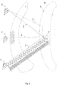
- Fig. 1 schematically illustrates a prior-art GNSS scenario 100.
- Receiver 110 receives GNSS signals from any number of satellites in view, such as from satellites 120, 130 and 140. The signals pass through the earth's ionosphere 150 and through the earth's troposphere 160. Each signal has multiple carrier frequencies, such as for example frequencies L1 and L2.
- Receiver 110 determines from the signals respective approximate (apparent) distances to the satellites (so called pseudo-ranges, PR1, PR2, ..., PRm). Pseudo-range determinations are distorted by signal-path variations resulting from passage of the signals through the ionosphere 150 and the troposphere 160, and from multipath effects, as schematically illustrated by reference 170 on Fig. 1 .
- Pseudo-ranges can be determined using the C/A code with an error of about one meter.
- the phases of the L1 and L2 carriers can be measured with an accuracy of 0.01 - 0.05 cycles (corresponding to pseudo-range errors of 2 mm to 1 cm).
- Phase measurements of the carriers are influenced by the dispersive effects of the ionosphere, which vary over time.
- phase observations Due to the much higher accuracy, the processing of the phase observations is advantageous for precise GNSS positioning.
- a complication arises in that the exact number of cycles between the receiver and the satellite is a priori unknown. More specifically, the phase observations are ambiguous by an ambiguity term which is a product of an unknown integer number and the wavelength of the carrier signal. To handle these unknown integers, they can simply be estimated as floating-point numbers within the GNSS parameter estimation. The corresponding position result is called a float solution.
- the float solution can be improved by fixing the estimated floating-point numbers to integer values by corresponding known methods (e.g. the LAMBDA method).
- the GNSS parameter estimation can afterwards be recomputed with the fixed integer values for the integer ambiguities.
- artificial observations can be computed from the original ones by forming linear combinations from the observations. This is true both for the code and the phase observations.
- linear combinations have different properties compared to the original observations.
- Popular linear combinations are the Melbourne-Wuebbena (MW) linear combination, the widelane linear combination, the geometric-free linear combination (also called ionospheric linear combination) and the ionospheric-free linear combination (also called geometric linear combination). Their properties are beneficial with respect to dedicated applications (see for example WO2011/034614 A2 ).
- the MW linear combination eliminates the effect of the ionosphere, of the geometry, of the clocks, and of the troposphere
- the geometric-free linear combination is independent of receiver clocks and geometry (orbits, station coordinates)
- the ionospheric-free linear combination eliminates the first-order effect of the ionospheric path delay.
- GNSS positioning accuracy is generally limited by measurement errors that can be classified as either common mode or noncommon mode.
- Common-mode errors have nearly identical effects on all receivers operating in a limited geographic area (e.g. 50 km).
- Noncommon-mode errors are distinct even for two receivers with minimal antenna separation.
- Relative positioning allows common-mode errors to be mitigated by differencing the observations of the rover with observations of a reference station at a known location near the rover, e.g., within 50-100 km.
- the reference station observations can be collected at a physical base station or estimated from observations of a network of reference stations (see for example US 5,477,458 and US 5,899,957 ).
- PPP precise point positioning
- absolute positioning uses a single GNSS receiver together with precise satellite orbit and clock data to reduce satellite-related error sources.
- a dual-frequency receiver can remove the first-order effect of the ionosphere by using the ionospheric-free linear combination.
- position solutions are accurate in a range of centimeters to decimeters.
- the utility of PPP is limited by the need to wait longer than desired for the float position solution to converge to centimeter accuracy. This waiting time is called convergence time.
- PPP processing uses undifferenced carrier-phase observations so that the ambiguity terms are corrupted by satellite and receiver phase biases.
- Methods have been proposed in the prior art for integer ambiguity resolution in PPP processing (see for example WO2011/034614 A2 and Yang Gao, "Precise Point Positioning and Its Challenges", Inside GNSS (2006), Vol. 1, No. 8, pp. 16-18 ).
- a conventional way to deal with the problems of PPP is described in international application WO 2011/034614 A2 .
- This involves generating synthetic base station data which preserves the integer nature of carrier phase data.
- a set of corrections is computed per satellite (a MW-bias, a code leveled clock error and a phase leveled clock error) from global network data.
- a rover can use the MW-combination to solve widelane ambiguities and use ionospheric-free code/phase observations to solve the N1 (narrowlane) ambiguities.
- the rover can achieve cm-level accuracy positioning in real-time, meaning that there is an action (e.g., data is processed, results are computed) as soon as the required information for that action is available.
- the advantage of this approach is that it is insensitive to ionospheric activity, the disadvantage is that the convergence time is longer than desired.
- US 2013/0044026 A1 describes a method to make use of an ionosphere model and further derive an ionospheric phase bias per satellite in addition to other corrections (a MW-bias, a code leveled clock error and a phase leveled clock error) to generate synthetic base station data.
- the synthetic base station data generated with this approach preserves the integer nature of carrier phase data, and it can be used for both single and dual frequency rovers.
- This approach requires an ionosphere model in general, and the rover convergence time depends heavily on the accuracy of the ionosphere model provided. Therefore, it is necessary to provide not only the ionosphere model itself but also its accuracy to the methods and apparatus for the GNSS data processing.
- a SBAS satellite based augmentation system
- a SBAS is a system that supports wide-area or regional augmentation through the use of additional satellite-broadcast messages.
- Such systems are commonly composed of multiple ground stations, located at accurately-surveyed points. The ground stations take measurements of one or more of the GNSS satellite signals and other environmental factors which may impact the signals received by the users. Using these measurements, information messages are created and sent to one or more satellites for broadcast to the end users.
- a SBAS provides correction data to increase the integrity and accuracy of a single frequency, code based positioning with GNSS whereas the correction data are broadcasted by communication satellites and can be received directly with the GNSS receiver.
- GNSS Global System for Mobile Communications
- a SBAS provides correction data to increase the integrity and accuracy of a single frequency, code based positioning with GNSS whereas the correction data are broadcasted by communication satellites and can be received directly with the GNSS receiver.
- WAAS Wide Area Augmentation System
- EGNOS European Geostationary Navigation Overlay Service
- SBAS ionospheric vertical delays
- IGPs ionospheric grid points
- GIVEs grid ionospheric vertical errors
- US patent No. 5,828,336 presents a method and a device for providing real-time wide-area differential GPS signals to allow users with a GPS receiver to obtain improved GPS positioning.
- the ionosphere correction system in this document uses a real-time Kalman filter to compute sun-fixed ionospheric delay maps and the associated formal error maps.
- the formal error map can be used to evaluate the quality of the ionospheric correction broadcast to the user, and to block the broadcast of suspect data.
- the formal error is determined by the total electron content (TEC) data weights, the observation geometry, the data equation, and the random-walk standard deviation (see Mannucci, A. J., Wilson, B. D, Edwards, C. D. (1993): "A New Method for Monitoring the Earth's Ionospheric Total Electron Content Using the GPS Global Network". Proceedings of ION GPS-93, pp. 1323-1332 ).
- GIVE grid ionospheric vertical error
- GIVE values are required to bound the actual error with 99.9% confidence to meet the requirement of integrity and accuracy.
- the scaling factors and the two additional error contributions considered in the GIVE values improve the agreement between the provided error indicator and the true error (compared to the previous approach in Mannucci, A. J., Wilson, B. D, Edwards, C. D. (1993): "A New Method for Monitoring the Earth's Ionospheric Total Electron Content Using the GPS Global Network". Proceedings of ION GPS-93, pp. 1323 - 1332 ). Nevertheless, the GIVE is mainly based on the formal errors and therefore a direct reference to the true error of the provided delay is not given.
- the residual error means the difference between ionospheric vertical delay experienced by the receiver and vertical ionospheric delay interpolated from broadcast delays at the IGP which the receiver uses in its position computation.
- the GIVE value might be computed as the largest residual at all available ionospheric pierce points (IPPs) which relate to the IGP through the interpolation process.
- the set from which the largest residual is computed consists of IPPs located within 5 degrees from the IGP.
- the method according to claim 1 enables to improve the accuracy information of an ionosphere model by making use of carrier phase observations having fixed or converged ambiguities.
- the fixed or converged ambiguities offer the possibility to provide residuals to the estimated ionosphere model which could be considered as quasi-true (in the range of a few centimeters). Therefore, the convergence times of a rover station provided with the accuracy information is thus significantly reduced compared to prior art methods.
- phase observations having fixed or converged ambiguities are used to generate the accuracy information. By doing so, it can be ensured that the generated accuracy information is of sufficient quality.
- the method takes into account that the ionosphere is quite inhomogeneous due to, for example, sun activity and therefore also large model errors with respect to the true ionospheric delay arise in certain areas. In other words, there are large residuals from the parameter estimation in certain areas.
- Conventional approaches such as GIVE providing accuracy information for an ionosphere model rely on the standard deviation of the parameter estimation. However, the standard deviation does not properly reflect large inhomogeneities in the residuals since the standard deviation is only influenced by the overall residuals.
- the present invention provides improved accuracy information which properly reflects the true errors of the ionosphere model.
- certain grid points are singled out because the number of nearby pierce points is sufficient to calculate vertical accuracy information at each selected grid point based on the vertical residual information of the identified pierce points within the threshold distance. Furthermore, a scale factor is computed for each selected grid point.
- the accuracy information for the ionosphere model is generated based on the vertical accuracy information computed for the selected grid points and an overall scale factor computed based on the computed scale factors. Therefore, accuracy information can notably be used for rover positioning to improve the convergence time compared to prior art methods.
- the prior art SBAS error indicator GIVE is mainly based on the formal error and has no direct relationship to a "true" model error.
- the fixed (or sufficiently converged) ambiguities of the absolute positioning offer the possibility to provide residuals to the estimated ionosphere model which may be considered as quasi-true (in the range of a few centimeters). Therefore, the accuracy indicator from those residuals is fundamentally different from the prior art GIVE.
- the method of the present invention and accordingly the accuracy level obtained by the method is also fundamentally different from the prior art GIVE.
- SBAS provides corrections to improve the single frequency, code based positioning accuracy to the range of a few meters (see for example Ahmadi, R., G. S. Becker, S.R.
- the method of the present invention provides accuracy information related to an ionosphere model to improve the convergence time of dual frequency, phase-based positioning, wherein the resulting positioning accuracy can be in the range of centimeters.
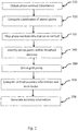
- Fig. 2 is a flowchart of a method according to one embodiment of the present invention.
- the method is carried out by a computer or a set of computers.
- the method is used for generating accuracy information for an ionosphere model calculated using a parameter estimation procedure based on phase observations made using a plurality of ground stations.
- Each phase observation is obtained from at least two signals transmitted from a satellite to a ground station, each of the at least two signals having a different frequency.
- the accuracy information is usable in a GNSS positioning system for estimating a position of a rover.
- steps S10 and S20 are performed.
- step S10 phase residual information of the parameter estimation procedure is obtained.
- step S20 coordinates of a pierce point on a sphere around the earth are computed.
- the sphere is defined by an ionosphere single layer model, wherein the coordinates indicate where the path of the signals from which the phase observation has been obtained pierces the sphere.
- step S30 the phase residual information of the corresponding phase observation is mapped, for each pierce point, to the vertical at the pierce point to generate vertical residual information.
- step S40 for each of at least some of the points of an equidistant grid on the sphere (each point being hereinafter referred to as "grid point"), pierce points within a threshold distance from the grid point on the sphere are identified.
- the grid points for which the number of identified pierce points exceeds a threshold number are selected in step S50.
- step S60 two values are computed for each selected grid point: vertical accuracy information at the selected grid point based on the vertical residual information of the identified pierce points, and a scale factor based on the vertical accuracy information computed for the selected grid point.
- the accuracy information for the ionosphere model is generated based on the vertical accuracy information computed for the selected grid points and an overall scale factor computed based on the computed scale factors in step S70.
- the ionosphere model provides the slant total electron content along a signal path through the ionosphere.
- the ionosphere single layer model concentrates the phase residual information of the parameter estimation procedure mapped to the vertical on the sphere.
- the ionosphere single layer model is used to derive the accuracy information for the (general) ionosphere model.
- the parameter estimation procedure comprises at least one of: a least square adjustment and a Kalman filter.
- a least square adjustment and a Kalman filter.
- any other suitable parameter estimation method may be used in the present invention.
- each phase observation is obtained from two of the at least two signals using a geometric-free linear combination.
- the geometric-free linear combination has the advantage that the resulting phase observation is independent of the positions of the satellite and the ground station.
- a phase observation has converged ambiguities if the standard deviation of the ambiguities is smaller than a threshold percentage of a cycle, the threshold percentage being a value comprised between 5 % and 25 %.
- the distance on the sphere between adjacent grid points at the equator is equal to a value between 2 degrees and 10 degrees. This range provides an advantage in that the grid is not too coarse while the number of grid points is sufficiently low to enable real-time processing.
- the threshold distance in step 40 is larger than the distance between adjacent grid points. In other words, circles defined by the threshold distance overlap for different grid points.
- the threshold number is any one of 5, 6, 7, 8, 9, 10, 11, 12, 13, 14, and 15 in step S50.
- the vertical accuracy information is a weighted root mean square computed from vertical residual information of the identified pierce points.
- a weight might be provided by the distance between each identified pierce point and the grid point for which the vertical accuracy information is calculated.
- the scale factor is a ratio between the weighted root mean square and the standard deviation of the ionosphere model at the grid point, wherein the standard deviation is a result of the parameter estimation procedure.
- the scale factor can be used to get the weighted root mean square from the standard deviation.
- the overall scale factor is a weighted mean of the scale factors.
- the number of residuals contributing to a scale factor can be used as a weight.
- step S70 further comprises computing S71, for each of all grid points of the equidistant grid, accuracy information based on the vertical accuracy information and the overall scale factor, and computing S72 coefficients of a functional expansion using a parameter estimation based on the accuracy information of each grid point to generate accuracy information covering the sphere.
- the functional expansion smoothes the accuracy information and provides a global representation of the accuracy information.
- step S71 further comprises, if the number of identified pierce points for the grid point is smaller than a first threshold number ("yes" after step S711), computing S712 the accuracy information by scaling the standard deviation of the ionosphere model at the grid point using at least the overall scale factor. Otherwise (“no" after step S711), if the number of identified pierce points for the grid point is larger than a second threshold number ("yes" after step S713), the vertical accuracy information of the grid point is used S714 as the accuracy information.
- the accuracy information is computed S715 by using a transition function between the vertical accuracy information of the grid point and the scaled standard deviation of the ionosphere model at the grid point.
- the first threshold number is smaller than the second threshold number.
- the vertical accuracy information is used as the accuracy information since the vertical accuracy information is of sufficient quality in this case. If the number of identified pierce points is low, the overall scale factor and an additional factor depending on the number of identified pierce points are used to scale the standard deviation since the vertical accuracy information is not of sufficient quality. A transition function interpolating between these two cases is used, if the number of identified pierce points is neither too low nor high enough.
- the accuracy information in step S71 is computed in the same manner as in the previous paragraph except that 1 ⁇ factor(n) ⁇ 1.5 if n ⁇ n2.
- the functional expansion in step S72 is a spherical harmonic expansion.
- the functional expansion is a spherical harmonic expansion and the number of coefficients of the spherical harmonic expansion depends on the number of phase observations used in the parameter estimation procedure. In other words, the more phase observations are available the more coefficients can be used, whereby the quality of the accuracy information (such as, for example, an accuracy indicator) can be improved.
- the coefficients of the spherical harmonic expansion are sent to a user to perform a GNSS related parameter estimation, e.g. for the positioning of a rover.
- a GNSS related parameter estimation e.g. for the positioning of a rover.
- the spherical harmonics coefficients of the accuracy information (such as, for example, the accuracy indicator) are transmitted.
- the user's rover, or any other suitable processing unit is able to directly compute the accuracy information everywhere on the sphere layer.
- the accuracy information is sent to a user for the positioning of a rover.
- the invention also relates to a computer program for carrying out one of the above described methods.
- processing entity 50 may include a bus 55, a central processing unit (CPU) 53, a main memory 57, a ROM 58, a storage device 59, an input device 52, an output device 54, and a communication interface 56.
- Bus 55 may include a path that permits communication among the components of processing entity 50.
- the CPU 53 may include a processor, a microprocessor, or processing logic that may interpret and execute instructions.
- Main memory 57 may include a RAM or another type of dynamic storage device that may store information and instructions for execution by CPU 53.
- ROM 58 may include a ROM device or another type of static storage device that may store static information and instructions for use by CPU 53.
- Storage device 59 may include a magnetic and/or optical recording medium and/or solid state medium (Flash memory) and its corresponding drive.
- Input device 52 may include a mechanism that permits an operator to input information to processing entity 50, such as a keypad, a keyboard, a touch-sensitive device, a mouse, a pen, voice recognition and/or biometric mechanisms, etc.
- Output device 54 may include a mechanism that outputs information to the operator, including a display, a printer, a speaker, etc.
- Communication interface 56 may include any transceiver-like mechanism that enables processing entity 50 to communicate with other devices and/or systems.
- communication interface 56 may include mechanisms for communicating with another device or system via a network.
- the processing entity 50 may perform certain operations or processes described herein. These operations may be performed in response to CPU 53 executing software instructions contained in a computer-readable medium, such as main memory 57, ROM 58, and/or storage device 59.
- a computer-readable medium may be defined as a physical or a logical memory device.
- a logical memory device may include memory space within a single physical memory device or distributed across multiple physical memory devices.
- Each of main memory 57, ROM 58 and storage device 59 may include computer-readable media.
- the magnetic and/or optical recording media (e.g., readable CDs or DVDs or Blu-ray/BDs) and/or solid state media of storage device 59 may also include computer-readable media.
- the software instructions may be read into main memory 57 from another computer-readable medium, such as storage device 59, or from another device via communication interface 56.
- main memory 59 may cause CPU 53 to perform operations or processes described herein.
- hardwired circuitry may be used in place of or in combination with software instructions to implement processes and/or operations described herein.
- implementations described herein are not limited to any specific combination of hardware and software.
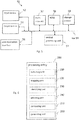
- Fig. 6 schematically illustrates functional units of a processing entity 200 according to one embodiment of the invention.
- the processing entity illustrated on Fig. 6 may for example be implemented as illustrated on Fig. 5 .
- the processing entity 200 is used for generating accuracy information for an ionosphere model calculated using a parameter estimation procedure based on phase observations made using a plurality of ground stations, wherein each phase observation is obtained from at least two signals transmitted from a satellite to a ground station, each of the at least two signals having a different frequency, and the accuracy information is usable in a GNSS positioning system for estimating a position of a rover. As shown in Fig.
- the processing entity 200 comprises an obtaining unit 210 configured to obtain, for each of at least some of the phase observations having fixed or converged ambiguities, phase residual information of the parameter estimation procedure, and compute coordinates of a pierce point on a sphere around the earth, the sphere being defined by an ionosphere single layer model, wherein the coordinates indicate where the path of the signals from which the phase observation has been obtained pierces the sphere.
- the processing entity 200 further comprises a mapping unit 220 configured to map, for each pierce point, the phase residual information of the corresponding phase observation to the vertical at the pierce point to generate vertical residual information.
- the processing entity 200 further comprises an identifying unit 230 configured to identify, for each of at least some of the points of an equidistant grid on the sphere, each point being hereinafter referred to as "grid point", pierce points within a threshold distance from the grid point on the sphere.
- the processing entity 200 further comprises a selecting unit 240 configured to select grid points for which the number of identified pierce points exceeds a threshold number.
- the processing entity 200 further comprises a computing unit 250 configured to compute, for each selected grid point, vertical accuracy information at the selected grid point based on the vertical residual information of the identified pierce points, and a scale factor based on the vertical accuracy information computed for the selected grid point.
- the processing entity 200 further comprises a generating unit 260 configured to generate the accuracy information for the ionosphere model based on the vertical accuracy information computed for the selected grid points and an overall scale factor computed based on the computed scale factors.
- the ionosphere model provides the slant total electron content along a signal path through the ionosphere.
- the ionosphere single layer model concentrates the phase residual information of the parameter estimation procedure mapped to the vertical on the sphere.
- the parameter estimation procedure comprises at least one of: a least square adjustment and a Kalman filter.
- each phase observation is obtained from two of the at least two signals using a geometric-free linear combination.
- a phase observation has converged ambiguities if the standard deviation of the ambiguities is smaller than a threshold percentage of a cycle, the threshold percentage being a value comprised between 5 % and 25 %.
- the distance on the sphere between adjacent grid points at the equator is equal to a value between 2 degrees and 10 degrees.
- the threshold distance used by the identifying unit 230 is larger than the distance between adjacent grid points.
- the threshold number used by the selecting unit 240 is any one of 5, 6, 7, 8, 9, 10, 11, 12, 13, 14, and 15.
- the vertical accuracy information is a weighted root mean square computed from vertical residual information of the identified pierce points.
- the scale factor is a ratio between the weighted root mean square and the standard deviation of the ionosphere model at the grid point, the standard deviation being a result of the parameter estimation procedure.
- the overall scale factor is a weighted mean of the scale factors.
- the generating unit 260 is further configured to compute, for each of all grid points of the equidistant grid, accuracy information based on the vertical accuracy information and the overall scale factor, and compute coefficients of a functional expansion using a parameter estimation based on the accuracy information of each grid point to generate accuracy information covering the sphere.
- the generating unit 260 is further configured to compute: if the number of identified pierce points for the grid point is smaller than a first threshold number, the accuracy information by scaling the standard deviation of the ionosphere model at the grid point using at least the overall scale factor; if the number of identified pierce points for the grid point is larger than a second threshold number, use the vertical accuracy information of the grid point as the accuracy information; and, if the number of identified pierce points for the grid point is larger than or equal to the first threshold number and smaller than or equal to the second threshold number, the accuracy information by using a transition function between the vertical accuracy information of the grid point and the scaled standard deviation of the ionosphere model at the grid point, wherein the first threshold number is smaller than the second threshold number.
- the generating unit 260 is configured to compute the accuracy information in the same manner as in the previous paragraph except that 1 ⁇ factor(n) ⁇ 1.5 if n ⁇ n2.
- the functional expansion is a spherical harmonic expansion.
- the functional expansion is a spherical harmonic expansion and the number of coefficients of the spherical harmonic expansion depends on the number of phase observations used in the parameter estimation procedure.
- the coefficients of the spherical harmonic expansion are sent to a user for the positioning of a rover.
- the accuracy information is sent to a user for the positioning of a rover.
- the ionosphere is an atmospheric layer which ranges from an altitude of approximately 60 km to an altitude of approximately 1,000 km.
- the propagation velocity of microwaves depends on the extent of ionization and this extend again depends mainly on the solar radiation.
- the effect on the signal propagation time is dispersive, i.e. it depends on the frequency of the signal. Therefore, the effect is also different for the code and the phase observations.
- the code observations (group delay) are delayed whereas the phase observations (phase delay) are advanced.
- the extent of ionization can be expressed by the Total Electron Content (TEC) which is typically expressed in TEC units (TECU).
- TEC Total Electron Content
- An ionosphere model provides the STEC along the signal path and, by using equations (1) and (2), code and phase observations can be corrected for the signal propagation time errors caused by the ionosphere.
- Those models either integrate along the signal path or use some simplifications. The most common and often used simplification is the Ionosphere Single Layer Model.
- mapping function given implicitly by equation (3) is derived from the geometry given by Fig. 7 .
- This is just one example for an ionospheric mapping functions, since there are also different ones (see for example Schaer S. (1999): “Mapping and Predicting the Earth's Ionosphere Using the Global Positioning System", Dissertation, Geodätisch-geophysikalische ever in der für, Vol. 59 ).
- measurements also called observations, are used to determine the parameters of a chosen model (see for example Strang G. and Borre K. (1997): “Linear algebra, geodesy, and GPS", Wellesley-Cambridge Press, Wellesley MA, USA ).
- a quite simple example would be the determination of a regression line whereas the sample points are the observations and the gradient and the y-intercept of the line are the estimated parameters.
- a parameter estimation approach determines the initially unknown parameters by minimizing the residuals.
- the residuals indicate afterwards how good the observations fit to estimated model.
- the matrix A is called design matrix because it describes how the parameters depend on the observations.
- a parameter estimation is designed well if every parameter could be estimated reliably from the available observations.
- the normal equation matrix depends on the design matrix and reflects therefore also the design respectively the constellation of the available observations.
- the a posteriori variance of unit weight is computed from all of the observation residuals.
- the variance matrix and therefore the standard deviation of one model parameter are determined by the constellation of the available observations and the overall residuals.
- Ionosphere models can be determined by means of parameter estimation with GNSS observations.
- the geometric-free linear combination of the first and second frequency is used for the observation input.
- L GF is the geometric-free carrier phase observation in meters
- f 1 and f 2 are the frequencies of the L 1 and L 2 phase observations, respectively
- ⁇ 1 and ⁇ 2 are the wavelengths of the L 1 and L 2 phase observations, respectively
- N 1 and N 2 are the L 1
- the linear combination is called geometric-free since all summands which are not frequency dependent vanish. Therefore, the satellite and station coordinates and the troposphere are not seen in equations (8) and (9). If a third frequency is available, a geometric-free linear combination can be composed by making use of it, i.e. it is no longer a requirement to use L1 and L2.
- the ionospheric signal delay I 1 GPS must generally be expressed by an ionosphere model, i.e. by a function of a number of unknowns describing the model.
- the parameter estimation determines these unknowns together with all other unknowns. These are the code and phase biases and depending on the estimation approach potentially also the ambiguities.
- a Global Ionosphere SLM expresses the global ionosphere by the VTEC values on a sphere layer.
- the ionospheric signal delay should be expressed by a function of the pierce point position and a number of unknowns describing the VTEC values on a sphere.
- a function is needed which is able to provide values dependent on latitude and longitude.
- Spherical harmonics exactly solve this problem and are therefore often used in earth sciences to represent global fields; e.g. the global gravitation field and the global magnetic field are typically expressed in spherical harmonics.
- the Associated Legendre Polynomials are known functions whereas the coefficients of the spherical harmonics expansion are initially unknown and have to be determined by the parameter estimation. The number of summands and therefore the resolution of the expansion are controlled by the chosen maximum degree.
- a global ionosphere SLM is represented by spherical harmonics (equation (10))
- its coefficients C n,m and S n,m are determined by the parameter estimation.
- the resolution of the model is controlled by the number of these coefficients. That means by increasing the degree and order of the expansion (which corresponds to an increase of the number of coefficients), the resolution of the spherical harmonic model is also increased.
- the order and degree cannot be chosen arbitrarily because the number of available observations and the distribution of the GNSS reference stations have to ensure numerical stability within the estimation approach.
- a 15 order and degree spherical harmonic model is typically used to estimate a global ionosphere SLM based on a global GNSS tracking network with 100 reference stations.
- Equation (10) which is a function of the model parameters C n,m and S n,m , gives the VTEC on the sphere layer.
- the standard deviation which is the square root of the variance, of every VTEC value on the sphere layer can be computed. This standard deviation is therefore based on the constellation of the available observations, i.e. the pierce point distribution and the overall residuals.
- the ionosphere can be quite inhomogeneous. Therefore, the resolution of a spherical expansion could be suitable with respect to the global ionospheric activity but large residuals, i.e.
- an arbitrary global ionosphere model is determined by GNSS precise point positioning.
- the parameter estimation is generally based on the observations equations (8) and (9) whereas the concrete parameter estimation approach is also arbitrary.
- the residual of the phase equation (8) provides the error of the estimated ionosphere model with high accuracy if the ambiguities are fixed to their true integer values or if their float value is determined precisely and moreover the satellite and receiver phase biases are estimated with millimeter accuracy.
- the first condition can be assured by taking the already determined ambiguities from a second processor, see US 2012/162007 A1 for example.
- the second condition can be fulfilled within the parameter estimation as the bias parameters are constant over time in principle.
- the phase residuals of the parameter estimation, mapped to the vertical, are given exemplarily by Fig. 8 .
- the derived standard deviation simply indicates the constellation of the available observations (northern part of South America is indicated as good as North America / Europe whereas the residuals there are much larger).
- the standard deviation is too optimistic in general (Note the different scale of the legend).
- an accuracy indicator for the estimated ionosphere model which is significant and additionally based completely on regional accuracy information can be derived.
- a suitable method based on a single layer ionosphere model is described in the following, in accordance with one embodiment of the invention.
- Phase residuals with high accuracy are available after the parameter estimation. They represent quasi-true errors of the estimated ionosphere model with respect to the true ionosphere delay.
- the pierce point coordinates are computed and the phase residual are mapped to the vertical. This is possible even if the parameter estimation approach itself is not based on a single layer model.
- An illustration of the SLM model with a pierce point of an observation link is already given by Fig. 7 .
- equation (11) By inserting equation (11) into equation (12), a quadratic equation is produced which has a positive and a negative solution for ⁇ , whereas the positive ⁇ provides the wanted position vector of the pierce point.
- the intersection angle is afterwards obtained by the dot product equation (13).
- Fig. 11 shows the weighted RMS of the residuals mapped to the vertical for the grid points. It is apparent that the RMS could only be computed in well observed regions (see also Fig. 8 ).
- w s and factor Possible values for w s and factor, depending on the number of available residuals are given exemplarily in the table.
- the value of factor can be set to an arbitrary value for n>14 due to w s being 0. n 0 1 2 3 4 5 6 7 8 9 10 11 12 13 14 >14 factor 3.0 2.7 2.4 2.1 1.8 1.6 1.4 1.3 1.2 1.1 1.0 1.0 1.0 1.0 w s 1.0 1.0 1.0 1.0 1.0 1.0 1.0 1.0 0.9 0.8 0.6 0.4 0.3 0.2 0.1 0
- Fig. 12 shows the accuracy indicator computed by equation (19) for all grid points.
- the accuracy indicators of all the grid points are input into a parameter estimation step to determine coefficients of a spherical harmonics expansion (However, the invention is not limited to determining coefficients of a spherical harmonics expansion. Other type of expansions may be used).
- the accuracy indicator given initially in the grid points only is smoothed and interpolated to a global representation.
- equation (10) the accuracy indicator can be computed everywhere on the sphere layer. This is illustrated by Fig. 13 .
- the accuracy indicator represented in spherical harmonics is computed directly after the ionosphere model parameter estimation by the processing entity (or "ionosphere processor").
- the associated processing occurs together with other processor tasks on a server collecting also the observation data of the global tracking network.
- the estimated ionosphere model and its accuracy indicator are transmitted to a user or its rover station respectively.
- the estimated ionosphere model and its accuracy indicator may be transmitted in the form of coefficients of a spherical harmonics expansion.
- Fig. 14a shows that the estimated ionosphere model and its accuracy indicator may be sent to a rover as part of a so-called correction message.
- the invention is however not limited to sending the accuracy information to a rover.
- the accuracy information may alternatively, or additionally, be transmitted to a server (or set of servers) so as to be further processed.
- the statement according to which "the accuracy information is usable in a GNSS positioning system for estimating a position of a rover" does not imply that the accuracy information is necessarily used for that purpose. Rather, it means that the information is suitable to be used for that purpose.
- the accuracy information may also be transmitted and used in a network to compute correction information associated with reference stations, etc.
- Fig. 14a shows that the correction message may be sent through a satellite link to a rover, the invention is not limited in that respect.
- the invention also covers embodiments wherein the correction message is transmitted via the Internet, any computer network, or any suitable radio link.
- three independent Kalman filters with different linear combinations are used to estimate ambiguities (see for example US7,432,853 B2 ).
- these ambiguity estimates are combined by a filter combiner as a preparation step for the actual ambiguity fixing.
- two of the three filters, each corresponding to an ambiguity for a specific linear combination are sufficient to determine fixed ambiguities for both phase observations (L1 and L2), i.e. the system is sufficiently determined with two filters, and using all three filters would become over-determined.
- the first filter uses a linear combination which is geometric-free and ionospheric-free
- the second filter uses the ionospheric-free linear combination
- the third one uses the geometric-free linear combination (called the ionosphere filter).
- the ionosphere filter has to set up unknowns, as defined by filter states, not only for the ambiguities but also for the ionosphere itself.
- the synthetic base station data is generated ionospheric-free, there will be no a priori information for the ionosphere states available. Ionosphere and ambiguity state need to converge from approximations and therefore the ambiguity states do not converge quickly. Thus, the ambiguity estimates of the ionosphere filter are heavily down-weighted in the filter combiner (as previously mentioned, the estimates of the other two filters are sufficient for the ambiguity fixing in a later step of the process).
- the generated synthetic base station data contains ionospheric propagation errors. Therefore, this provides a quite good approximation for the ionosphere available whereas the quality of the approximation is indicated by the accuracy indicator.
- the accuracy indicator is used to control the noise model of the ionosphere state. If a good approximation is indicated this is reflected by the noise model of the ionosphere state, i.e. the estimate of the ionosphere state is almost constrained to its approximation, and therefore the ambiguity converges more rapidly.
- the ambiguity estimates of the ionosphere filter contribute substantially to the filter combiner and the subsequent ambiguity fixing is significantly accelerated.
- Fig. 16 exemplarily compares the convergence times of rover stations in Europe with and without an ionosphere model and its accuracy. It confirms the expected reduction of the convergence times via experiment using real data. Especially, Fig.
- the mean convergence time decreased from 12 minutes (black) to 7 minutes (gray) which is an improvement of about 40%.
- the improvement is significant, e.g. the 90% percentile shows that with applying the ionosphere information the convergence time is shorter than 13 minutes in 90% of the test runs (gray). The corresponding convergence time is 20 minutes without applying ionosphere information (black), i.e. the improvement for the 90% percentile is 35%.
- GNSS precise point positioning methods include, but are not limited to: automatic positioning of agricultural machinery, civil construction machinery, and mining machinery; geodetic survey equipment; marine survey equipment; photogrammetry (including airborne platforms both manned and unmanned, the latter referred to as UAVs, unmanned aerial vehicles, or drones); GIS (geographic information system) equipment; and position monitoring systems (such as earthquake detection, bridge monitoring, and dam deformation).
Landscapes
- Engineering & Computer Science (AREA)
- Radar, Positioning & Navigation (AREA)
- Remote Sensing (AREA)
- Computer Networks & Wireless Communication (AREA)
- Physics & Mathematics (AREA)
- General Physics & Mathematics (AREA)
- Computer Security & Cryptography (AREA)
- Position Fixing By Use Of Radio Waves (AREA)
Claims (18)
- Procédé, exécuté par un ordinateur ou un ensemble d'ordinateurs, pour générer une information de précision pour un modèle d'ionosphère, le modèle d'ionosphère étant calculé en utilisant une procédure d'estimation de paramètre sur la base d'observations de phase réalisées en utilisant une pluralité de stations terrestres, dans lequel
chaque observation de phase est obtenue à partir d'au moins deux signaux transmis à partir d'un satellite vers une station terrestre, chacun des au moins deux signaux ayant une fréquence différente, et
l'information de précision est utilisable dans un système de positionnement GNSS pour estimer une position d'un astromobile,
le procédé comprenant les étapes :pour chacune d'au moins quelques-unes des observations de phase ayant des ambiguïtés fixes ou convergentes,d'obtention (S10) d'une information résiduelle de phase de la procédure d'estimation de paramètre ; etde calcul (S20) de coordonnées d'un point de percée sur une sphère autour de la terre, la sphère étant définie par un modèle d'ionosphère à couche unique, dans lequel les coordonnées indiquent où le trajet des signaux à partir desquels l'observation de phase a été obtenue perce la sphère ;d'association (S30), pour chaque point de percée, de l'information résiduelle de phase de l'observation de phase correspondante à la verticale au point de percée pour générer une information résiduelle verticale ;pour chacun d'au moins quelques-uns des points d'une grille équidistante sur la sphère, chaque point étant désigné ci-après sous le nom de « point de grille », d'identification (S40) de points de percée à l'intérieur d'une distance de seuil à partir du point de grille sur la sphère ;de sélection (S50) de points de grille pour lesquels le nombre de points de percée identifiés excède un nombre seuil ;caractérisé par les étapesde calcul (S60), pour chaque point de grille sélectionné,d'une information de précision verticale au point de grille sélectionné sur la base de l'information résiduelle verticale des points de percée identifiés, l'information de précision verticale étant une moyenne quadratique pondérée calculée à partir d'une information résiduelle verticale des points de percée identifiés, etd'un facteur d'échelle sur la base de l'information de précision verticale calculée pour le point de grille sélectionné, le facteur d'échelle étant un rapport entre la moyenne quadratique pondérée et un écart type du modèle d'ionosphère au point de grille, l'écart-type étant un résultat de la procédure d'estimation de paramètre ; etde génération (S70) de l'information de précision pour le modèle d'ionosphère sur la basede l'information de précision verticale calculée pour les points de grille sélectionnés, etd'un facteur d'échelle global calculé sur la base des facteurs d'échelle calculés, le facteur d'échelle global étant une moyenne pondérée des facteurs d'échelle,dans lequel la génération (S70) de l'information de précision pour le modèle d'ionosphère comprend les étapesde calcul (S71), pour chacun de tous les points de grille de la grille équidistante, d'une information de précision sur la base de l'information de précision verticale et dudit facteur d'échelle global, dans lequel(i) s'il y a suffisamment de points de percée identifiés pour un point de grille, l'information de précision verticale est utilisée comme étant l'information de précision puisque l'information de précision verticale est de qualité suffisante dans ce cas.(ii) si le nombre de points de percée identifiés est faible, le facteur d'échelle global et un facteur supplémentaire dépendant du nombre de points de percée identifiés sont utilisés pour mettre l'écart type à l'échelle puisque l'information de précision verticale n'est pas de qualité suffisante, et(iii) si le nombre de points de percée identifiés n'est ni trop faible ni suffisamment élevé, une fonction de transition interpolant entre ces deux cas est utilisée ; etde calcul (S72) de coefficients d'une expansion fonctionnelle en utilisant une estimation de paramètre sur la base de l'information de précision de chaque point de grille pour générer l'information de précision pour le modèle d'ionosphère couvrant la sphère. - Procédé selon la revendication 1, dans lequel le modèle d'ionosphère fournit le contenu électronique à inclinaison totale le long d'un trajet de signal à travers l'ionosphère.
- Procédé selon la revendication 1 ou 2, dans lequel le modèle d'ionosphère à couche unique concentre l'information résiduelle de phase de la procédure d'estimation de paramètre associée à la verticale sur la sphère.
- Procédé selon l'une quelconque des revendications précédentes, dans lequel la procédure d'estimation de paramètre comprend au moins un de :une compensation par moindres carrés etun filtre de Kalman.
- Procédé selon l'une quelconque des revendications précédentes, dans lequel chaque observation de phase est obtenue à partir de deux des au moins deux signaux en utilisant une combinaison linéaire exempte de géométrie.
- Procédé selon l'une quelconque des revendications précédentes, dans lequel une observation de phase a des ambiguïtés convergentes si l'écart type des ambiguïtés est plus petit qu'un pourcentage de seuil d'un cycle, le pourcentage de seuil étant une valeur comprise entre 5 % et 25 %.
- Procédé selon l'une quelconque des revendications précédentes, dans lequel la distance sur la sphère entre des points de grille adjacents à l'équateur est égale à une valeur comprise entre 2 degrés et 10 degrés.
- Procédé selon l'une quelconque des revendications précédentes, dans lequel, à l'étape d'identification (S40) de points de percée à l'intérieur d'une distance de seuil à partir du point de grille sur la sphère, la distance de seuil est plus grande que la distance entre des points de grille adjacents.
- Procédé selon l'une quelconque des revendications précédentes, dans lequel, à l'étape de sélection (S50) de points de grille pour lesquels le nombre de points de percée identifiés excède un nombre seuil, le nombre seuil est l'un quelconque parmi 5, 6, 7, 8, 9, 10, 11, 12, 13, 14 et 15.
- Procédé selon la revendication 1, dans lequel l'étape de calcul (S71) d'une information de précision pour chacun de tous les points de grille de la grille équidistante comprend :si le nombre de points de percée identifiés pour le point de grille est plus petit qu'un premier nombre seuil, un calcul (S711) de l'information de précision en mettant à l'échelle l'écart type du modèle d'ionosphère au point de grille en utilisant au moins le facteur d'échelle global,si le nombre de points de percée identifiés pour le point de grille est plus grand qu'un second nombre seuil, une utilisation (S714) de l'information de précision verticale du point de grille comme étant l'information de précision, etsi le nombre de points de percée identifiés pour le point de grille est plus grand ou égal au premier nombre seuil et inférieur ou égal au second nombre seuil, un calcul (S715) de l'information de précision en utilisant une fonction de transition entre l'information de précision verticale du point de grille et l'écart type mis à l'échelle du modèle d'ionosphère au point de grille,dans lequel le premier nombre seuil est plus petit que le second nombre seuil.
- Procédé selon la revendication 1, dans lequel l'information de précision est calculée en utilisant la fonction de transition suivante :
 IP est l'information de précision,s est l'écart type du modèle d'ionosphère au point de grille,wEchelle est le facteur d'échelle global,wMQ est l'information de précision verticale du point de grille,n représente le nombre de points de percée identifiés pour le point de grille,n1 représente le premier nombre seuil,n2 représente le second nombre seuil,w(n) = 1 si n < n1,w(n) = 0 si n > n2,0 < w(n) < 1 si n1 ≤ n ≤ n2,1 ≤ facteur(n) ≤ 3 si n ≤ 2.
 - Procédé selon la revendication 1, dans lequel l'information de précision est calculée en utilisant la fonction de transition suivante :
 IP est l'information de précision,s est l'écart type du modèle d'ionosphère au point de grille,wEchelle est le facteur d'échelle global,wMQ est l'information de précision verticale du point de grille,n représente le nombre de points de percée identifiés pour le point de grille,n1 représente le premier nombre seuil,n2 représente le second nombre seuil,w(n) = 1 si n < n1,w(n) = 0 si n > n2,0 < w(n) < 1 si n1 ≤ n ≤ n2,1 ≤ facteur(n) ≤ 1,5 si n ≤ n2.
 - Procédé selon la revendication 1, dans lequel l'expansion fonctionnelle est une expansion harmonique sphérique.
- Procédé selon la revendication 13, dans lequel l'expansion fonctionnelle est une expansion harmonique sphérique et le nombre de coefficients de l'expansion harmonique sphérique dépend du nombre d'observations de phase utilisées dans la procédure d'estimation de paramètre.
- Procédé selon la revendication 13 ou 14, dans lequel les coefficients de l'expansion harmonique sphérique sont envoyés à un utilisateur pour le positionnement d'un astromobile.
- Procédé selon l'une quelconque des revendications précédentes, dans lequel l'information de précision est envoyée à un utilisateur pour le positionnement d'un astromobile.
- Programme informatique comprenant des instructions exécutables par un ordinateur configurées, lorsqu'elles sont exécutées sur un ordinateur, pour provoquer l'exécution par l'ordinateur d'un procédé selon l'une quelconque des revendications précédentes.
- Entité de traitement, pour générer une information de précision pour un modèle d'ionosphère, le modèle d'ionosphère étant calculé en utilisant une procédure d'estimation de paramètre sur la base d'observations de phase réalisées en utilisant une pluralité de stations terrestres, dans laquelle
chaque observation de phase est obtenue à partir d'au moins deux signaux transmis à partir d'un satellite vers une station terrestre, chacun des au moins deux signaux ayant une fréquence différente, et
l'information de précision est utilisable dans un système de positionnement GNSS pour estimer une position d'un astromobile,
l'entité de traitement (200) comprenant :une unité d'obtention (210) configurée pour, pour chacune d'au moins quelques-unes des observations de phase ayant des ambiguïtés fixes ou convergentes,obtenir une information résiduelle de phase de la procédure d'estimation de paramètre ; etcalculer des coordonnées d'un point de percée sur une sphère autour de la terre, la sphère étant définie par un modèle d'ionosphère à couche unique, dans laquelle les coordonnées indiquent où le trajet des signaux à partir desquels l'observation de phase a été obtenue perce la sphère ;une unité d'association (220) configurée pour associer, pour chaque point de percée, l'information résiduelle de phase de l'observation de phase correspondante à la verticale au point de percée pour générer une information résiduelle verticale ;une unité d'identification (230) configurée pour, pour chacun d'au moins quelques-uns des points d'une grille équidistante sur la sphère, chaque point étant désigné ci-après sous le nom de « point de grille », identifier des points de percée à l'intérieur d'une distance de seuil à partir du point de grille sur la sphère ;une unité de sélection (240) configurée pour sélectionner des points de grille pour lesquels le nombre de points de percée identifiés excède un nombre seuil ;caractérisée parune unité de calcul (250) configurée pour calculer, pour chaque point de grille sélectionné,une information de précision verticale au point de grille sélectionné sur la base de l'information résiduelle verticale des points de percée identifiés, l'information de précision verticale étant une moyenne quadratique pondérée calculée à partir de l'information résiduelle verticale des points de percée identifiés, etun facteur d'échelle sur la base de l'information de précision verticale calculée pour le point de grille sélectionné, le facteur d'échelle étant un rapport entre la moyenne quadratique pondérée et un écart type du modèle d'ionosphère au point de grille, l'écart-type étant un résultat de la procédure d'estimation de paramètre ; etune unité de génération (260) configurée pour générer l'information de précision pour le modèle d'ionosphère sur la base de l'information de précision verticale calculée pour les points de grille sélectionnés et d'un facteur d'échelle global calculé sur la base des facteurs d'échelle calculés, le facteur d'échelle global étant une moyenne pondérée des facteurs d'échelle, dans laquelle l'unité de génération (260) est configurée pourcalculer, pour chacun de tous les points de grille de la grille équidistante, une information de précision sur la base de l'information de précision verticale et du facteur d'échelle global, dans laquelle(i) s'il y a suffisamment de points de percée identifiés pour un point de grille, l'information de précision verticale est utilisée comme étant l'information de précision puisque l'information de précision verticale est de qualité suffisante dans ce cas.(ii) si le nombre de points de percée identifiés est faible, le facteur d'échelle global et un facteur supplémentaire dépendant du nombre de points de percée identifiés sont utilisés pour mettre l'écart type à l'échelle puisque l'information de précision verticale n'est pas de qualité suffisante, et(iii) si le nombre de points de percée identifiés n'est ni trop faible ni suffisamment élevé, une fonction de transition interpolant entre ces deux cas est utilisée ; etcalculer des coefficients d'une expansion fonctionnelle en utilisant une estimation de paramètre sur la base de l'information de précision de chaque point de grille pour générer l'information de précision pour le modèle d'ionosphère couvrant la sphère.
Applications Claiming Priority (1)
| Application Number | Priority Date | Filing Date | Title |
|---|---|---|---|
| US201261738953P | 2012-12-18 | 2012-12-18 |
Publications (3)
| Publication Number | Publication Date |
|---|---|
| EP2746811A2 EP2746811A2 (fr) | 2014-06-25 |
| EP2746811A3 EP2746811A3 (fr) | 2015-03-25 |
| EP2746811B1 true EP2746811B1 (fr) | 2020-10-28 |
Family
ID=49958164
Family Applications (1)
| Application Number | Title | Priority Date | Filing Date |
|---|---|---|---|
| EP13196884.4A Active EP2746811B1 (fr) | 2012-12-18 | 2013-12-12 | Procédés de génération d'informations de précision sur un modèle ionosphérique pour des applications de navigation par satellite |
Country Status (2)
| Country | Link |
|---|---|
| US (1) | US9557419B2 (fr) |
| EP (1) | EP2746811B1 (fr) |
Families Citing this family (40)
| Publication number | Priority date | Publication date | Assignee | Title |
|---|---|---|---|---|
| US9576082B2 (en) * | 2012-02-08 | 2017-02-21 | California Institute Of Technology | Ionospheric slant total electron content analysis using global positioning system based estimation |
| FR2998976B1 (fr) * | 2012-11-30 | 2015-01-16 | Thales Sa | Procede et systeme de determination d'une erreur de l'estimation du temps de la traversee de la ionosphere |
| DE102013218492B9 (de) * | 2013-09-16 | 2014-10-16 | Deutsches Zentrum für Luft- und Raumfahrt e.V. | Verfahren und Vorrichtung zur Bestimmung mindestens eines stützpunktspezifischen vertikalen Gesamtelektroneninhalts |
| US20150145722A1 (en) * | 2013-11-27 | 2015-05-28 | Honeywell International Inc. | Using sbas ionospheric delay measurements to mitigate ionospheric error |
| EP3489720A1 (fr) * | 2014-10-30 | 2019-05-29 | Mitsubishi Electric Corporation | Appareil de positionnement |
| US9945954B2 (en) * | 2014-11-20 | 2018-04-17 | Honeywell International Inc. | Using space-based augmentation system (SBAS) grid ionosphere vertical error (GIVE) information to mitigate ionosphere errors for ground based augmentation systems (GBAS) |
| JP6298176B2 (ja) | 2014-12-02 | 2018-03-20 | 三菱電機株式会社 | 測位装置 |
| EP3035080B1 (fr) | 2014-12-16 | 2022-08-31 | Trimble Inc. | Positionnement d'un système satellite de navigation impliquant la génération d'informations de correction |
| CN104613932A (zh) * | 2015-01-04 | 2015-05-13 | 中国人民解放军信息工程大学 | 利用垂线偏差与重力异常确定似大地水准面模型的方法 |
| US10495758B2 (en) | 2015-03-27 | 2019-12-03 | Honeywell International Inc. | Systems and methods using multi frequency satellite measurements to mitigate spatial decorrelation errors caused by ionosphere delays |
| US9921314B2 (en) | 2015-04-20 | 2018-03-20 | Honeywell International Inc. | Using code minus carrier measurements to mitigate spatial decorrelation errors caused by ionosphere delays |
| CN104933316B (zh) * | 2015-07-02 | 2017-07-21 | 华东交通大学 | 一种基于双参数混合正则化的电离层掩星反演方法 |
| EP3130943B1 (fr) | 2015-08-14 | 2022-03-09 | Trimble Inc. | Positionnement d'un système satellite de navigation impliquant la génération d'informations de correction troposphérique |
| US10345448B2 (en) | 2016-01-21 | 2019-07-09 | Honeywell International Inc. | Using space based augmentation system (SBAS) ephemeris sigma information to reduce ground based augmentation systems (GBAS) ephemeris decorrelation parameter |
| US9989644B2 (en) | 2016-02-09 | 2018-06-05 | Honeywell International Inc. | Use of wide area reference receiver network data to mitigate local area error sources |
| CN106991710B (zh) * | 2017-04-17 | 2020-06-23 | 中国人民解放军63796部队 | 静止气象卫星云图网格点自动纠错方法 |
| RU2653066C1 (ru) * | 2017-08-29 | 2018-05-07 | Олег Иванович Завалишин | Способ определения ионосферного шторма с помощью наземной стационарной локальной контрольно-корректирующей станции |
| CN108332649B (zh) * | 2018-02-07 | 2020-04-24 | 桂林电子科技大学 | 一种滑坡形变综合预警方法及系统 |
| CN108828626B (zh) * | 2018-07-02 | 2020-11-06 | 中国人民解放军战略支援部队信息工程大学 | 基于实时网格的网络rtk电离层延迟内插方法及系统 |
| CN111260779B (zh) * | 2018-11-30 | 2022-12-27 | 华为技术有限公司 | 地图构建方法、装置及系统、存储介质 |
| CN109612427A (zh) * | 2019-01-16 | 2019-04-12 | 兰州交通大学 | 一种多传感器协同的无人机公路桥梁形变检测方法及系统 |
| WO2020178982A1 (fr) * | 2019-03-05 | 2020-09-10 | 三菱電機株式会社 | Dispositif de traitement d'informations et procédé de transmission d'informations d'augmentation de positionnement |
| JP6925563B2 (ja) * | 2019-03-05 | 2021-08-25 | 三菱電機株式会社 | 情報処理装置および測位補強情報送信方法 |
| CN111831965B (zh) * | 2019-04-23 | 2023-09-12 | 千寻位置网络有限公司 | Ssr中upd改正数的完好性监测方法及其装置 |
| EP3730970B1 (fr) | 2019-04-23 | 2023-10-04 | Leica Geosystems AG | Fourniture de données de correction atmosphérique pour un système rtk de réseau gnss par codage des données selon une hiérarchie d'arbre de quadrants |
| CN114430808A (zh) * | 2019-06-06 | 2022-05-03 | 星盟国际有限公司 | 变化电离层延迟下的单历元伪距定位 |
| US20210116575A1 (en) * | 2019-10-16 | 2021-04-22 | Navmatic, Inc. | Updating atmospheric delay models within a geographic region |
| CN113066099B (zh) * | 2019-12-13 | 2023-12-19 | 视云融聚(广州)科技有限公司 | 一种基于球形坐标系的摄像机标签轨迹跟随方法 |
| CN110986747B (zh) * | 2019-12-20 | 2021-03-19 | 桂林电子科技大学 | 一种滑坡位移组合预测方法及系统 |
| CN110988929B (zh) * | 2019-12-21 | 2020-09-22 | 中国电子科技集团公司第二十研究所 | 电离层影响下的gbas系统性能评估方法及装置 |
| CN111273318B (zh) * | 2020-02-25 | 2021-10-19 | 东南大学 | 一种基于抛物线的区域对流层湿延迟计算方法 |
| CN112649899B (zh) * | 2020-11-19 | 2023-01-24 | 中国电波传播研究所(中国电子科技集团公司第二十二研究所) | 一种全球电离层数据同化和预报方法 |
| CN113221395B (zh) * | 2021-03-16 | 2023-10-20 | 禁核试北京国家数据中心 | 基于分层介质的地震走时参数化网格模型构建方法及应用 |
| CN114518586B (zh) * | 2021-03-17 | 2024-04-30 | 山东科技大学 | 一种基于球谐展开的gnss精密单点定位方法 |
| CN113109632B (zh) * | 2021-04-08 | 2023-04-14 | 三门峡职业技术学院 | 一种用斜测电离图反演f2层参数的方法 |
| CN116106948A (zh) * | 2021-11-09 | 2023-05-12 | 千寻位置网络(浙江)有限公司 | 网络rtk抗电离层干扰定位方法及相关设备 |
| CN114265093B (zh) * | 2021-12-06 | 2023-07-18 | 中国人民解放军海军工程大学 | 一种卫星时钟钟差预报方法、系统、介质、设备及终端 |
| CN114757238B (zh) * | 2022-06-15 | 2022-09-20 | 武汉地铁集团有限公司 | 地铁保护区变形监测的方法、系统、电子设备和存储介质 |
| WO2024039380A1 (fr) * | 2022-08-19 | 2024-02-22 | Google Llc | Apprentissage fédéré de modèles atmosphériques pour navigation par satellite |
| CN117055074B (zh) * | 2023-10-13 | 2024-01-23 | 中国电子科技集团公司第十五研究所 | 相对精度综合量化评估方法、服务器及存储介质 |
Family Cites Families (6)
| Publication number | Priority date | Publication date | Assignee | Title |
|---|---|---|---|---|
| US5477458A (en) | 1994-01-03 | 1995-12-19 | Trimble Navigation Limited | Network for carrier phase differential GPS corrections |
| US5828336A (en) | 1996-03-29 | 1998-10-27 | The United States Of America As Represented By The Administrator Of The National Aeronautics And Space Administration | Robust real-time wide-area differential GPS navigation |
| US7432853B2 (en) | 2003-10-28 | 2008-10-07 | Trimble Navigation Limited | Ambiguity estimation of GNSS signals for three or more carriers |
| WO2011034615A2 (fr) | 2009-09-19 | 2011-03-24 | Trimble Navigation Limited | Traitement du signal gnss avec détermination d'ambiguïtés de récepteur mobile (rover) |
| CN101419274B (zh) | 2008-12-08 | 2011-06-29 | 北京航空航天大学 | 电离层延迟误差的获取方法及系统 |
| US9170335B2 (en) | 2011-02-14 | 2015-10-27 | Trimble Navigation Limited | GNSS signal processing with ionosphere model for synthetic reference data |
-
2013
- 2013-12-09 US US14/101,119 patent/US9557419B2/en active Active
- 2013-12-12 EP EP13196884.4A patent/EP2746811B1/fr active Active
Non-Patent Citations (1)
| Title |
|---|
| None * |
Also Published As
| Publication number | Publication date |
|---|---|
| EP2746811A2 (fr) | 2014-06-25 |
| US20140292573A1 (en) | 2014-10-02 |
| US9557419B2 (en) | 2017-01-31 |
| EP2746811A3 (fr) | 2015-03-25 |
Similar Documents
| Publication | Publication Date | Title |
|---|---|---|
| EP2746811B1 (fr) | Procédés de génération d'informations de précision sur un modèle ionosphérique pour des applications de navigation par satellite | |
| Paziewski et al. | Assessment of GPS+ Galileo and multi-frequency Galileo single-epoch precise positioning with network corrections | |
| US10281587B2 (en) | Navigation satellite system positioning involving the generation of correction information | |
| US10078140B2 (en) | Navigation satellite system positioning involving the generation of advanced correction information | |
| Rovira-Garcia et al. | Assessing the quality of ionospheric models through GNSS positioning error: methodology and results | |
| Rovira‐Garcia et al. | Fast precise point positioning: A system to provide corrections for single and multi‐frequency navigation | |
| Melgard et al. | G2-the first real-time GPS and GLONASS precise orbit and clock service | |
| Crespillo et al. | Design and evaluation of robust M-estimators for GNSS positioning in urban environments | |
| Jokinen | Enhanced ambiguity resolution and integrity monitoring methods for precise point positioning | |
| Martin | GNSS precise point positioning: The enhancement with GLONASS | |
| Ya’acob et al. | Determination of GPS total electron content using single layer model (SLM) ionospheric mapping function | |
| Basile et al. | Analysis on the potential performance of GPS and Galileo Precise Point Positioning using simulated Real-Time Products | |
| Verhagen | On the approximation of the integer least-squares success rate: which lower or upper bound to use | |
| Ma et al. | Flight-test evaluation of integer ambiguity resolution enabled PPP | |
| Wang et al. | Comparison of three widely used multi‐GNSS real‐time single‐frequency precise point positioning models using the International GNSS Service real‐time service | |
| Männel et al. | Ionospheric corrections for single-frequency tracking of GNSS satellites by VLBI based on co-located GNSS | |
| Pu et al. | Triple-frequency ambiguity resolution for GPS/Galileo/BDS between long-baseline network reference stations in different ionospheric regions | |
| Rovira-Garcia et al. | A real-time world-wide ionospheric model for single and multi-frequency precise navigation | |
| Paziewski et al. | Application of SBAS pseudorange and carries phase signals to precise instantaneous single-frequency positioning | |
| Elsobeiey et al. | Impact of second-order ionospheric delay on GPS precise point positioning | |
| Suzuki et al. | Evaluation of dual-frequency GBAS performance using data from public receiver networks | |
| Desai et al. | Ionodelay models for satellite based navigation system | |
| Tabti et al. | Improving availability of the EGNOS system in Algeria for dual frequency | |
| Rahman et al. | ECEF position accuracy and reliability: Continent scale differential GNSS approaches (phase C report) | |
| Li et al. | Toward Wide-Area and High-Precision Positioning With LEO Constellation Augmented PPP-RTK |
Legal Events
| Date | Code | Title | Description |
|---|---|---|---|
| PUAI | Public reference made under article 153(3) epc to a published international application that has entered the european phase |
Free format text: ORIGINAL CODE: 0009012 |
|
| 17P | Request for examination filed |
Effective date: 20131212 |
|
| AK | Designated contracting states |
Kind code of ref document: A2 Designated state(s): AL AT BE BG CH CY CZ DE DK EE ES FI FR GB GR HR HU IE IS IT LI LT LU LV MC MK MT NL NO PL PT RO RS SE SI SK SM TR |
|
| AX | Request for extension of the european patent |
Extension state: BA ME |
|
| PUAL | Search report despatched |
Free format text: ORIGINAL CODE: 0009013 |
|
| AK | Designated contracting states |
Kind code of ref document: A3 Designated state(s): AL AT BE BG CH CY CZ DE DK EE ES FI FR GB GR HR HU IE IS IT LI LT LU LV MC MK MT NL NO PL PT RO RS SE SI SK SM TR |
|
| AX | Request for extension of the european patent |
Extension state: BA ME |
|
| RIC1 | Information provided on ipc code assigned before grant |
Ipc: G01S 19/07 20100101AFI20150213BHEP |
|
| R17P | Request for examination filed (corrected) |
Effective date: 20150428 |
|
| RBV | Designated contracting states (corrected) |
Designated state(s): AL AT BE BG CH CY CZ DE DK EE ES FI FR GB GR HR HU IE IS IT LI LT LU LV MC MK MT NL NO PL PT RO RS SE SI SK SM TR |
|
| RAP1 | Party data changed (applicant data changed or rights of an application transferred) |
Owner name: TRIMBLE INC. |
|
| STAA | Information on the status of an ep patent application or granted ep patent |
Free format text: STATUS: EXAMINATION IS IN PROGRESS |
|
| 17Q | First examination report despatched |
Effective date: 20170804 |
|
| GRAP | Despatch of communication of intention to grant a patent |
Free format text: ORIGINAL CODE: EPIDOSNIGR1 |
|
| STAA | Information on the status of an ep patent application or granted ep patent |
Free format text: STATUS: GRANT OF PATENT IS INTENDED |
|
| INTG | Intention to grant announced |
Effective date: 20200520 |
|
| GRAS | Grant fee paid |
Free format text: ORIGINAL CODE: EPIDOSNIGR3 |
|
| GRAA | (expected) grant |
Free format text: ORIGINAL CODE: 0009210 |
|
| STAA | Information on the status of an ep patent application or granted ep patent |
Free format text: STATUS: THE PATENT HAS BEEN GRANTED |
|
| AK | Designated contracting states |
Kind code of ref document: B1 Designated state(s): AL AT BE BG CH CY CZ DE DK EE ES FI FR GB GR HR HU IE IS IT LI LT LU LV MC MK MT NL NO PL PT RO RS SE SI SK SM TR |
|
| REG | Reference to a national code |
Ref country code: GB Ref legal event code: FG4D |
|
| REG | Reference to a national code |
Ref country code: CH Ref legal event code: EP |
|
| REG | Reference to a national code |
Ref country code: AT Ref legal event code: REF Ref document number: 1328766 Country of ref document: AT Kind code of ref document: T Effective date: 20201115 |
|
| REG | Reference to a national code |
Ref country code: DE Ref legal event code: R096 Ref document number: 602013073574 Country of ref document: DE |
|
| REG | Reference to a national code |
Ref country code: IE Ref legal event code: FG4D |
|
| REG | Reference to a national code |
Ref country code: AT Ref legal event code: MK05 Ref document number: 1328766 Country of ref document: AT Kind code of ref document: T Effective date: 20201028 |
|
| REG | Reference to a national code |
Ref country code: NL Ref legal event code: MP Effective date: 20201028 |
|
| PG25 | Lapsed in a contracting state [announced via postgrant information from national office to epo] |
Ref country code: NO Free format text: LAPSE BECAUSE OF FAILURE TO SUBMIT A TRANSLATION OF THE DESCRIPTION OR TO PAY THE FEE WITHIN THE PRESCRIBED TIME-LIMIT Effective date: 20210128 Ref country code: NL Free format text: LAPSE BECAUSE OF FAILURE TO SUBMIT A TRANSLATION OF THE DESCRIPTION OR TO PAY THE FEE WITHIN THE PRESCRIBED TIME-LIMIT Effective date: 20201028 Ref country code: PT Free format text: LAPSE BECAUSE OF FAILURE TO SUBMIT A TRANSLATION OF THE DESCRIPTION OR TO PAY THE FEE WITHIN THE PRESCRIBED TIME-LIMIT Effective date: 20210301 Ref country code: RS Free format text: LAPSE BECAUSE OF FAILURE TO SUBMIT A TRANSLATION OF THE DESCRIPTION OR TO PAY THE FEE WITHIN THE PRESCRIBED TIME-LIMIT Effective date: 20201028 Ref country code: FI Free format text: LAPSE BECAUSE OF FAILURE TO SUBMIT A TRANSLATION OF THE DESCRIPTION OR TO PAY THE FEE WITHIN THE PRESCRIBED TIME-LIMIT Effective date: 20201028 Ref country code: GR Free format text: LAPSE BECAUSE OF FAILURE TO SUBMIT A TRANSLATION OF THE DESCRIPTION OR TO PAY THE FEE WITHIN THE PRESCRIBED TIME-LIMIT Effective date: 20210129 |
|
| REG | Reference to a national code |
Ref country code: LT Ref legal event code: MG4D |
|
| PG25 | Lapsed in a contracting state [announced via postgrant information from national office to epo] |
Ref country code: BG Free format text: LAPSE BECAUSE OF FAILURE TO SUBMIT A TRANSLATION OF THE DESCRIPTION OR TO PAY THE FEE WITHIN THE PRESCRIBED TIME-LIMIT Effective date: 20210128 Ref country code: ES Free format text: LAPSE BECAUSE OF FAILURE TO SUBMIT A TRANSLATION OF THE DESCRIPTION OR TO PAY THE FEE WITHIN THE PRESCRIBED TIME-LIMIT Effective date: 20201028 Ref country code: AT Free format text: LAPSE BECAUSE OF FAILURE TO SUBMIT A TRANSLATION OF THE DESCRIPTION OR TO PAY THE FEE WITHIN THE PRESCRIBED TIME-LIMIT Effective date: 20201028 Ref country code: IS Free format text: LAPSE BECAUSE OF FAILURE TO SUBMIT A TRANSLATION OF THE DESCRIPTION OR TO PAY THE FEE WITHIN THE PRESCRIBED TIME-LIMIT Effective date: 20210228 Ref country code: SE Free format text: LAPSE BECAUSE OF FAILURE TO SUBMIT A TRANSLATION OF THE DESCRIPTION OR TO PAY THE FEE WITHIN THE PRESCRIBED TIME-LIMIT Effective date: 20201028 Ref country code: PL Free format text: LAPSE BECAUSE OF FAILURE TO SUBMIT A TRANSLATION OF THE DESCRIPTION OR TO PAY THE FEE WITHIN THE PRESCRIBED TIME-LIMIT Effective date: 20201028 Ref country code: LV Free format text: LAPSE BECAUSE OF FAILURE TO SUBMIT A TRANSLATION OF THE DESCRIPTION OR TO PAY THE FEE WITHIN THE PRESCRIBED TIME-LIMIT Effective date: 20201028 |
|
| PG25 | Lapsed in a contracting state [announced via postgrant information from national office to epo] |
Ref country code: HR Free format text: LAPSE BECAUSE OF FAILURE TO SUBMIT A TRANSLATION OF THE DESCRIPTION OR TO PAY THE FEE WITHIN THE PRESCRIBED TIME-LIMIT Effective date: 20201028 |
|
| REG | Reference to a national code |
Ref country code: DE Ref legal event code: R097 Ref document number: 602013073574 Country of ref document: DE |
|
| PG25 | Lapsed in a contracting state [announced via postgrant information from national office to epo] |
Ref country code: SM Free format text: LAPSE BECAUSE OF FAILURE TO SUBMIT A TRANSLATION OF THE DESCRIPTION OR TO PAY THE FEE WITHIN THE PRESCRIBED TIME-LIMIT Effective date: 20201028 Ref country code: EE Free format text: LAPSE BECAUSE OF FAILURE TO SUBMIT A TRANSLATION OF THE DESCRIPTION OR TO PAY THE FEE WITHIN THE PRESCRIBED TIME-LIMIT Effective date: 20201028 Ref country code: CZ Free format text: LAPSE BECAUSE OF FAILURE TO SUBMIT A TRANSLATION OF THE DESCRIPTION OR TO PAY THE FEE WITHIN THE PRESCRIBED TIME-LIMIT Effective date: 20201028 Ref country code: LT Free format text: LAPSE BECAUSE OF FAILURE TO SUBMIT A TRANSLATION OF THE DESCRIPTION OR TO PAY THE FEE WITHIN THE PRESCRIBED TIME-LIMIT Effective date: 20201028 Ref country code: RO Free format text: LAPSE BECAUSE OF FAILURE TO SUBMIT A TRANSLATION OF THE DESCRIPTION OR TO PAY THE FEE WITHIN THE PRESCRIBED TIME-LIMIT Effective date: 20201028 Ref country code: SK Free format text: LAPSE BECAUSE OF FAILURE TO SUBMIT A TRANSLATION OF THE DESCRIPTION OR TO PAY THE FEE WITHIN THE PRESCRIBED TIME-LIMIT Effective date: 20201028 |
|
| REG | Reference to a national code |
Ref country code: CH Ref legal event code: PL |
|
| PG25 | Lapsed in a contracting state [announced via postgrant information from national office to epo] |
Ref country code: DK Free format text: LAPSE BECAUSE OF FAILURE TO SUBMIT A TRANSLATION OF THE DESCRIPTION OR TO PAY THE FEE WITHIN THE PRESCRIBED TIME-LIMIT Effective date: 20201028 Ref country code: MC Free format text: LAPSE BECAUSE OF FAILURE TO SUBMIT A TRANSLATION OF THE DESCRIPTION OR TO PAY THE FEE WITHIN THE PRESCRIBED TIME-LIMIT Effective date: 20201028 |
|
| PLBE | No opposition filed within time limit |
Free format text: ORIGINAL CODE: 0009261 |
|
| REG | Reference to a national code |
Ref country code: BE Ref legal event code: MM Effective date: 20201231 |
|
| STAA | Information on the status of an ep patent application or granted ep patent |
Free format text: STATUS: NO OPPOSITION FILED WITHIN TIME LIMIT |
|
| GBPC | Gb: european patent ceased through non-payment of renewal fee |
Effective date: 20210128 |
|
| 26N | No opposition filed |
Effective date: 20210729 |
|
| PG25 | Lapsed in a contracting state [announced via postgrant information from national office to epo] |
Ref country code: AL Free format text: LAPSE BECAUSE OF FAILURE TO SUBMIT A TRANSLATION OF THE DESCRIPTION OR TO PAY THE FEE WITHIN THE PRESCRIBED TIME-LIMIT Effective date: 20201028 Ref country code: IT Free format text: LAPSE BECAUSE OF FAILURE TO SUBMIT A TRANSLATION OF THE DESCRIPTION OR TO PAY THE FEE WITHIN THE PRESCRIBED TIME-LIMIT Effective date: 20201028 Ref country code: IE Free format text: LAPSE BECAUSE OF NON-PAYMENT OF DUE FEES Effective date: 20201212 Ref country code: LU Free format text: LAPSE BECAUSE OF NON-PAYMENT OF DUE FEES Effective date: 20201212 Ref country code: FR Free format text: LAPSE BECAUSE OF NON-PAYMENT OF DUE FEES Effective date: 20201228 |
|
| PG25 | Lapsed in a contracting state [announced via postgrant information from national office to epo] |
Ref country code: SI Free format text: LAPSE BECAUSE OF FAILURE TO SUBMIT A TRANSLATION OF THE DESCRIPTION OR TO PAY THE FEE WITHIN THE PRESCRIBED TIME-LIMIT Effective date: 20201028 Ref country code: LI Free format text: LAPSE BECAUSE OF NON-PAYMENT OF DUE FEES Effective date: 20201231 Ref country code: CH Free format text: LAPSE BECAUSE OF NON-PAYMENT OF DUE FEES Effective date: 20201231 Ref country code: GB Free format text: LAPSE BECAUSE OF NON-PAYMENT OF DUE FEES Effective date: 20210128 |
|
| PG25 | Lapsed in a contracting state [announced via postgrant information from national office to epo] |
Ref country code: IS Free format text: LAPSE BECAUSE OF FAILURE TO SUBMIT A TRANSLATION OF THE DESCRIPTION OR TO PAY THE FEE WITHIN THE PRESCRIBED TIME-LIMIT Effective date: 20210228 Ref country code: TR Free format text: LAPSE BECAUSE OF FAILURE TO SUBMIT A TRANSLATION OF THE DESCRIPTION OR TO PAY THE FEE WITHIN THE PRESCRIBED TIME-LIMIT Effective date: 20201028 Ref country code: MT Free format text: LAPSE BECAUSE OF FAILURE TO SUBMIT A TRANSLATION OF THE DESCRIPTION OR TO PAY THE FEE WITHIN THE PRESCRIBED TIME-LIMIT Effective date: 20201028 Ref country code: CY Free format text: LAPSE BECAUSE OF FAILURE TO SUBMIT A TRANSLATION OF THE DESCRIPTION OR TO PAY THE FEE WITHIN THE PRESCRIBED TIME-LIMIT Effective date: 20201028 |
|
| PG25 | Lapsed in a contracting state [announced via postgrant information from national office to epo] |
Ref country code: MK Free format text: LAPSE BECAUSE OF FAILURE TO SUBMIT A TRANSLATION OF THE DESCRIPTION OR TO PAY THE FEE WITHIN THE PRESCRIBED TIME-LIMIT Effective date: 20201028 |
|
| PG25 | Lapsed in a contracting state [announced via postgrant information from national office to epo] |
Ref country code: BE Free format text: LAPSE BECAUSE OF NON-PAYMENT OF DUE FEES Effective date: 20201231 |
|
| PGFP | Annual fee paid to national office [announced via postgrant information from national office to epo] |
Ref country code: DE Payment date: 20231227 Year of fee payment: 11 |