EP2734706B1 - Verfahren und system zum anzeigen von daten im zusammenhang mit dem bohren eines bohrlochs - Google Patents
Verfahren und system zum anzeigen von daten im zusammenhang mit dem bohren eines bohrlochs Download PDFInfo
- Publication number
- EP2734706B1 EP2734706B1 EP12817920.7A EP12817920A EP2734706B1 EP 2734706 B1 EP2734706 B1 EP 2734706B1 EP 12817920 A EP12817920 A EP 12817920A EP 2734706 B1 EP2734706 B1 EP 2734706B1
- Authority
- EP
- European Patent Office
- Prior art keywords
- borehole
- coordinate system
- drilling
- value
- data
- Prior art date
- Legal status (The legal status is an assumption and is not a legal conclusion. Google has not performed a legal analysis and makes no representation as to the accuracy of the status listed.)
- Not-in-force
Links
Images


Classifications
-
- E—FIXED CONSTRUCTIONS
- E21—EARTH DRILLING; MINING
- E21B—EARTH DRILLING, e.g. DEEP DRILLING; OBTAINING OIL, GAS, WATER, SOLUBLE OR MELTABLE MATERIALS OR A SLURRY OF MINERALS FROM WELLS
- E21B43/00—Methods or apparatus for obtaining oil, gas, water, soluble or meltable materials or a slurry of minerals from wells
-
- E—FIXED CONSTRUCTIONS
- E21—EARTH DRILLING; MINING
- E21B—EARTH DRILLING, e.g. DEEP DRILLING; OBTAINING OIL, GAS, WATER, SOLUBLE OR MELTABLE MATERIALS OR A SLURRY OF MINERALS FROM WELLS
- E21B44/00—Automatic control systems specially adapted for drilling operations, i.e. self-operating systems which function to carry out or modify a drilling operation without intervention of a human operator, e.g. computer-controlled drilling systems; Systems specially adapted for monitoring a plurality of drilling variables or conditions
-
- E—FIXED CONSTRUCTIONS
- E21—EARTH DRILLING; MINING
- E21B—EARTH DRILLING, e.g. DEEP DRILLING; OBTAINING OIL, GAS, WATER, SOLUBLE OR MELTABLE MATERIALS OR A SLURRY OF MINERALS FROM WELLS
- E21B7/00—Special methods or apparatus for drilling
- E21B7/04—Directional drilling
Definitions
- boreholes are drilled by rotating a drill bit attached to a drill string.
- the drill bit is mounted on the lower end of the drill string as part of a bottomhole assembly (BHA) and is rotated by rotating the drill string at the surface, by actuation of downhole motors, or both. With weight applied by the drill string, the rotating drill bit engages the earth formation and forms a borehole toward a target zone.
- BHA bottomhole assembly
- a number of downhole devices placed in close proximity to the drill bit measure downhole operating parameters associated with the drilling and downhole conditions.
- Such devices may include sensors for measuring downhole temperature and pressure, azimuth and inclination of the borehole, and formation parameter-measuring devices.
- the recited information and other information may be provided to the drilling operator so that drilling plan may be implemented.
- WO 97/15749 A2 discloses a closed loop drilling system forming part of the state of the art relative to the present disclosure.
- Coupled or “couples” is intended to mean either an indirect or direct connection. Thus, if a first device couples to a second device, that connection may be through a direct connection or through an indirect connection via other devices and connections.
- Bodyhole shall mean a hole drilled into the Earth's crust used directly or indirectly for the exploration or extraction of natural resources, such as oil, natural gas or water.
- Controllable parameter shall mean a parameter whose values may be directly or indirectly controlled during the drilling process (e.g., rotational speed of a drill bit, drilling fluid flow rate, weight-on-bit).
- Real-time with respect to calculations based on underlying data, shall mean that the calculations are completed within six minutes of reading the underlying data.
- Remote shall mean greater than one mile from a designated location.
- “Surface”, in reference to the surface of the Earth, shall mean any location starting 10 feet below the ground and extending upward relative to the local force of gravity.
- the various embodiments are directed to methods and systems of displaying information for use during drilling of a borehole, and in some cases methods and systems of automating the drilling process.
- the specification first turns to a description of illustrative systems, and then provides a more detailed explanation of operation of various embodiments within the illustrative systems.
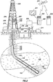
- Figure 1 shows an example subsea drilling operation.
- Figure 1 shows a bottomhole assembly 100 for a subsea drilling operation, where the bottomhole assembly 100 illustratively comprises a drill bit 102 on the distal end of the drill string 104.
- Various logging-while-drilling (LWD) and measuring-while-drilling (MWD) tools may also be coupled within the bottomhole assembly 100.
- LWD logging-while-drilling
- MWD measuring-while-drilling
- LWD tools measure properties of the surrounding formation (e.g., resistivity, porosity, permeability)
- MWD tools measure properties associated with the borehole (e.g., inclination, and direction).
- a logging tool 106 may be coupled just above the drill bit, where the logging tool may read data associated with the borehole 108 (e.g., MWD tool), or the logging tool 106 may read data associated with the surrounding formation (e.g., a LWD tool).
- the bottomhole assembly 100 may comprise a mud motor 112.
- the mud motor 112 may derive energy from drilling fluid flowing within the drill string 104 and, from the energy extracted, the mud motor 112 may rotate the drill bit 102 (and if present the logging tool 106) separate and apart from rotation imparted to the drill string by surface equipment. Additional logging tools may reside above the mud motor 112 in the drill string, such as illustrative logging tool 114.
- the bottomhole assembly 100 is lowered from a drilling platform 116 by way of the drill string 104.
- the drill string 104 extends through a riser 118 and a well head 120.
- Drilling equipment supported within and around derrick 123 may rotate the drill string 104, and the rotational motion of the drill string 104 and/or the rotational motion created by the mud motor 112 causes the bit 102 to form the borehole 108 through the formation material 122.
- the volume defined between the drill string 104 and the borehole 108 is referred to as the annulus 125.
- the borehole 108 penetrates subterranean zones or reservoirs, such as reservoir 110, believed to contain hydrocarbons in a commercially viable quantity.
- the bottomhole assembly 100 may further comprise a communication subsystem.
- illustrative bottomhole assembly 100 comprises a telemetry module 124.
- Telemetry module 124 may communicatively couple to the various logging tools 106 and 114 and receive logging data measured and/or recorded by the logging tools 106 and 114.
- the telemetry module 124 may communicate logging data to the surface using any suitable communication channel (e.g., pressure pulses within the drilling fluid flowing in the drill string 104, acoustic telemetry through the pipes of the drill string 104, electromagnetic telemetry, optical fibers embedded in the drill string 104, or combinations), and likewise the telemetry module 124 may receive information from the surface over one or more of the communication channels.
- Figure 2 shows an example land-based drilling operation.
- Figure 2 shows a drilling platform 200 equipped with a derrick 202 that supports a hoist 204.
- the hoist 204 suspends a top drive 208, the hoist 204 and top drive rotate and lower the drill string 104 through the wellhead 210.
- Drilling fluid is pumped by mud pump 214 through flow line 216, stand pipe 218, goose neck 220, top drive 208, and down through the drill string 104 at high pressures and volumes to emerge through nozzles or jets in the drill bit 102.
- the drilling fluid then travels back up the wellbore via the annulus 125, through a blowout preventer (not specifically shown), and into a mud pit 224 on the surface.
- the drilling fluid is cleaned and then circulated again by mud pump 214.
- the drilling fluid is used to cool the drill bit 102, to carry cuttings from the base of the borehole to the surface, and to balance the hydrostatic pressure in the rock formations.
- one or more transducers convert the pressure signal into electrical signals for a signal digitizer 238 (e.g., an analog-to-digital converter). While three transducers 232, 234 and/or 236 are illustrated, a greater number of transducers, or fewer transducers, may be used in particular situations.
- the digitizer 238 supplies a digital form of the pressure signals to a surface computer 240 or some other form of a data processing device.
- Surface computer 240 operates in accordance with software (which may be stored on a computer-readable storage medium) to monitor and control the drilling processing, including instructions to process and decode the received signals related to telemetry from downhole.
- the surface computer 240 is communicatively coupled to many devices in and around the drilling site, and such communicative couplings are not shown so as not to unduly complicate the discussion.
- data gathered from in and around the drill site, as well as the logging data sent by the telemetry module 124, may be displayed on a display device 241 (display techniques discussed more below).
- the surface computer 240 may forward the data to another computer system, such as a computer system 242 at the operations center of the oilfield services provider, the operations center remote from the drill site.
- the communication of data between computer system 240 and computer system 242 may take any suitable form, such as over the Internet, by way of a local or wide area network, or as illustrated over a satellite 244 link.
- Some or all of the calculations associated with controlling the drilling may be performed at the computer system 242.
- the specification now turns to displaying drilling status and/or controlling the drilling in accordance with at least some embodiments.
- the drilling of the borehole may proceed through various types of formations. It follows that the downhole operating conditions change over time, and the drilling operator reacts to such changes by adjusting controllable parameters.
- Example controllable parameters comprise weight-on-bit (WOB), drilling fluid flow through the drill pipe (flow rate and pressure), rotational speed of the drill string (e.g., rotational rate applied by the top drive unit), and the density and viscosity of the drilling fluid.
- WOB weight-on-bit
- drilling fluid flow through the drill pipe flow rate and pressure
- rotational speed of the drill string e.g., rotational rate applied by the top drive unit
- density and viscosity of the drilling fluid e.g., density and viscosity of the drilling fluid.
- Illustrative surface computer 240 couples to the display device 241 and displays on the display device a graphic for visually tracking the drilling operations.
- various aspects are executed within an integration and visualization platform, such as surface computer 240 executing DecisionSpace® available from Halliburton Energy Services, Inc. of Houston, Texas.
- the integration and visualization platform receives indications of downhole operating conditions and controllable parameters (e.g., weight-on-bit, fluid flow rate, and bit speed).
- the surface computer 240 also sends control signals to change various controllable parameters (e.g., weight-on-bit, drilling fluid flow rate, and bit speed).
- software plug-in 280 may be installed and executed by the surface computer 240 along with the integration platform.
- the functionality of the plug-in 280 may be: incorporated into the integration platform; executed on the remote computer system 242; or the functionality spread among the available computer systems.
- the plug-in 280 may be stored in, for example, one or more computer-readable mediums.
- Figure 3 shows a method that may be implemented, in whole or in part, by the plug-in 280. In particular, the method starts (block 300) and proceeds to reading data associated with the drilling of the borehole (block 302).
- the reading of the data is during the drilling process, and at least one datum of the data is based on a controllable parameter (e.g., weight-on-bit, fluid flow rate, and bit speed).
- the illustrative method then proceeds to calculating an operational value related to drilling the borehole, the operational value based on the data (block 304). For example, calculating the operational value may involve calculating a current rate-of-penetration for the drilling process.
- the operational value is to be provided to the drilling operator for use in controlling an ongoing drilling process, the calculating is in real-time with reading of the data.
- the next step in the illustrative method implemented by the plug-in 280 is determining a target value of the operational value (block 306), the target value based at least in part on the data associated with the drilling process.
- the target value may be a target rate-of-penetration, including target values for each controllable parameter that affects rate-of-penetration (e.g., weight-on-bit, fluid flow rate, and rotational speed).
- the target value may be calculated to reduce mechanical specific energy, reduce hydro-mechanical specific energy, or to reduce overall cost of drilling the borehole.
- the target value may be a target rate-of-penetration that reduces another value (e.g ., surface energy consumption), and thus the target value need not always be calculated to optimize the operational value itself.
- the target value since (as discussed more below) the target value is to be provided to the drilling operator for use in controlling an ongoing drilling process, the calculating of the target value is in real-time with reading of the underlying data.
- multiple versions of the illustrative method may be executing simultaneously, each method providing respective information regarding respective (but distinct) operational values. In this way, the operator may view multiple results to ascertain patterns (e.g ., both methods indicate a similar change desirable).
- the illustrative method then proceeds to displaying a first borehole trajectory on a display device (block 308). That is, to aid the drilling operator in visualizing the current state of drilling the borehole, the computer system 240 illustratively executing the plug-in 280 may display on the display device 241 a depiction of the borehole trajectory, as illustrated in Figure 4 .
- Figure 4 shows a view of a borehole trajectory 400 that may be shown on the display device 241.
- the borehole trajectory 400 may comprise an indication of the portion of the borehole that has already been drilled (in Figure 4 by portion 402 shown with a solid line), and also an indication of the expected future path of the borehole that has yet to be drilled (in Figure 4 by portion 404 shown with a dashed line). In other cases, the expected future path may be omitted from the display.
- the borehole trajectory 400 may be a three-dimensional representation of the borehole, and thus the three-dimensional representation may be projected onto the two-dimensional surface of the display device in such a way as to appear to the drilling operator as three-dimensional. In other cases, the borehole trajectory 400 may be a two-dimensional representation displayed on the display device 241.
- the illustrative method may further comprise superimposing a coordinate system over the borehole trajectory on the display device (block 310).
- the superimposed coordinate system may reside proximate to a distal end of the borehole trajectory.
- Figure 4 illustratively shows a three-dimensional coordinate system 410 superimposed over the distal end 412 of the borehole trajectory (e.g ., the current distal end of the borehole, not necessarily the planned ultimate distal end of the borehole trajectory).
- a two-dimensional coordinate system may be used.
- the coordinate system 410 has at least one non-spatial axis, and in some cases each axis is a non-spatial axis. Stated oppositely, in some embodiments there are no spatial axes in the coordinate system 410.
- the path of borehole trajectory 400 being a spatial path, may be considered to be plotted against a spatial coordinate system (which spatial coordinate system may or may not be specifically shown), and the coordinate system 410 is separate and apart from any spatial coordinate system for the borehole trajectory 410.
- the illustrative method may further comprise plotting, within the coordinate system, an indication of the operational value and an indication of the target value (block 312).
- the target value is illustratively plotted as ball or dot 414, and the target value is illustratively plotted as a ball or dot 416.
- Figure 4 thus shows an example situation where there is a difference between the operational value as calculated, and the target value.
- Rate-of-penetration may be controlled by parameters such as weight-on-bit, rotational speed of the drill bit, and drilling fluid flow rate.
- the coordinate system 410 has a weight-on-bit axis 418, a rotational speed of the drill bit axis 420, and a drilling fluid flow rate axis 422.
- the dot 414 showing the current operational value in the form a rate-of-penetration may thus be plotted within the coordinate system 410 at a location that corresponds to the weight-on-bit, rotational speed of the drill bit, and drilling fluid flow rate that provides the current rate-of-penetration.
- dot 416 The target value in this example situation is shown by dot 416, which dot 416 is plotted in the coordinate system 410 at a weight-on-bit, rotational speed of the drill bit, and drilling fluid flow rate that, if utilized, should provide the target rate-of-penetration.
- Figure 5 shows a plot being a portion of the view of Figure 4 , but in greater detail.
- Figure 5 shows the operational value dot 414 plotted at a location within the coordinate system 410 corresponding to the parameters that make up the operational parameter.
- dot 414 represents a rate of penetration based on: the current weight-on-bit plotted with respect to the weight-on-bit axis 418; the current rotational speed of the drill bit with respect to the rotational speed axis 420; and the current drilling fluid flow rate with respect to the drilling fluid flow rate axis 422.
- the target value plotted as dot 416 is different than the operational value, and the target value dot 416 plotted at a location within the coordinate system 410 corresponding to the parameters that should be required to make the operational parameter value match the target value.
- the target value should be achieved with the current weight-on-bit (i.e ., the operational value and target value share a weight-on-bit plotted point, but with increases in both rotational speed and drilling fluid flow rate).
- the illustrative coordinate system has three non-spatial axes; however, an additional dimension may be encoded in the visual display in the form of a recognizable artifact.
- the magnitude of the calculated operational value may be shown in the form of the size of the dot 414.
- the target value is greater than the current operational value, and the size of the dot 416 is increased.
- an additional dimension of information is thus encoded in the size of the dots plotting the operational value and target value.
- Other recognizable artifacts include differences in color, shape, opacity, or combinations.
- the magnitude of the current operational value may be displayed in number form in, on, around or near the plotted dot.
- the drilling operator is provided a wealth of information regarding the drilling processing, and can choose one or more controllable parameters for adjustment in an attempt to have the operational value move toward target value.
- the operational value being rate-of-penetration in the example of Figure 5
- the drilling operation may increase rotational speed of the bit, and likewise increase drilling fluid flow rate.
- the plug-in 280 may determine the difference between the parameters that make up the location of the current operational value and the parameters that, if used, should cause the system to achieve the target value, and automatically adjust one or more controllable parameters (i.e ., adjust one or more of the controllable parameters without input from the human drilling operator) (block 314). Thereafter, the method may end (block 316), in most cases to be immediately restarted for the next incremental depth and/or length of the borehole.
- the plug-in 280 may implement one or more proportional-integral-differential (PID) control loops (e.g ., one for each controllable parameter), which PID control loops continually adjust the controllable parameters in an attempt to have the operational value match the target value.
- PID proportional-integral-differential
- the plug-in 280 may suggest to the drilling operator a change in one or more controllable parameters, and have the drilling operator make the changes after application of human intuition.
- the coordinate system moves relative to the borehole trajectory.
- the coordinate system may remain at a fixed location on the display device 241, and the depiction of the borehole trajectory shifts.
- previously plotted portions of the borehole trajectory 400 remain at stationary locations on the display device, and the coordinate system 410 moves to the new distal end of the borehole trajectory.
- the plotted indications of the operational value and target value are removed and re-plotted with each new location of the coordinate system 410 relative to the borehole trajectory 400.
- Figure 6 shows a plot being a portion of what may displayed on a display device 241 by the plug-in 280 in yet still further embodiments.
- Figure 6 shows a series of plotted dots, where the upper dots 600 represent previous operational values, and the lower dots 602 represent previous target values.
- the plug-in 280 in these embodiments may refrain from removing previous plotted values from the display device 241. Viewing a scene including the previous plotted values as in Figure 6 thus provides feedback to the drilling operator as to how well previous changes to controllable parameters are affecting the operational value relative to the target value.
- the specification now turns to use of actual values from nearby wells.
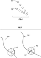
- Figure 7 shows a plot that may be displayed on the display device 241 in accordance with at least some embodiments.
- Figure 7 shows the borehole trajectory 400 for the current borehole being drilled, along with a coordinate system 410, in this case illustratively shown as a cube ( e.g ., a three-dimensional coordinate system).
- the method executed by the plug-in 280 may include scanning one or more databases of information for the presence of nearby boreholes that are being drilled or have been drilled.
- the plug-in 280 may access a database on the computer system 242 at the operations center for the service provider.
- the plug-in 280 may determine the proximity of nearby boreholes that have already drilled through the formation material which is or is about to be drilled by the current borehole.
- the idea being that the actual values associated with the nearby borehole may provide a better set of target value for the current borehole than the plug-in 280 could create based on models or characteristic equations. For example, if the borehole associated with borehole trajectory 700 has already drilled though a target shale formation, the actual rates-of-penetration achieved in the nearby borehole may be a better indication of how to set controllable parameters in the current borehole.
- the plug-in 280 may show the borehole trajectory 700, coordinate system 702, as well as a plot or dot 704 indicative of the actual value achieved in the nearby borehole.
- the drilling operation may thus use the indications of the controllable parameters from the nearby borehole as a guide to setting the controllable parameters in the current borehole to achieve the target value.
- the plug-in 280 may instead plot within the coordinate system 410 associated with the current wellbore the actual value achieved in the nearby borehole as the target value.
- the plug-in 280 may scan one or more data bases for nearby boreholes, and in some cases the radius or other distance criteria may be selectable ( e.g ., along a mineral lease line). If a nearby well meets the distance criteria, the plug-in 280 may find data regarding a corresponding depth, and the actual rate-of-penetration achieved (including the values of the controllable parameters used). The plug-in 280 may then substitute the actual rate-of-penetration from the nearby well to be the target value in the current borehole, and plot the target value rate-of-penetration along with the operational value rate-of-penetration in the coordinate system 410.
- the number of dimensions shown on the coordinate system 410 is not limited to two or three, and thus the coordinate system may be an n-dimensional space.
- Four or more dimensions may be plotted as the dimensions need not be orthogonally related.
- the system may be operated in the "scan mode" - scanning for nearby boreholes such that actual values from those nearby wells may be used - or the system may be operated where only the data related to the current borehole is used.
- the previously plotted operational values and target values may be animated in a repeating loop to show the progression over time.
- the system may enable the drilling operator to "play back" the drilling situation starting from any previous depth or time to any target depth or time, including the present.
- the target value calculated and displayed may be a limit value. That is, in these embodiments rather than calculating a target values (e.g ., an optimized rate-of-penetration), the target value may merely plot a limit to the operational value (e.g ., a maximum limit, minimum limit, deviation limit).
- the telemetry module 124 may be a computer system (controlling an encoding system, such as a mud pulser). The computer system associated with the telemetry module 124 may calculate the various parameters, and telemeter the some or all the parameters to the surface computer systems.
- the telemetry module 124 may control or change one or more controllable parameters (e.g ., speed of the mud motor 112, or weight-on-bit in systems where weight-on-bit is controllable downhole).
- controllable parameters e.g ., speed of the mud motor 112, or weight-on-bit in systems where weight-on-bit is controllable downhole.
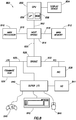
- Figure 8 illustrates a computer system 800 in accordance with at least some embodiments.
- Computer system 800 is illustrative of a computer system upon which some or all of the various methods may be performed.
- computer system 800 may be illustrative of computer system 240 or 242.
- computer system 800 may be representative of a computer system disposed with telemetry module 124.
- computer system 800 comprises a main processor 810 coupled to a main memory array 812, and various other peripheral computer system components, through integrated host bridge 814.
- the main processor 810 may be a single processor core device, or a processor implementing multiple processor cores.
- computer system 800 may implement multiple main processors 810.
- the main processor 810 couples to the host bridge 814 by way of a host bus 816, or the host bridge 814 may be integrated into the main processor 810.
- the computer system 800 may implement other bus configurations or bus-bridges in addition to, or in place of, those shown in Figure 8 .
- the main memory 812 couples to the host bridge 814 through a memory bus 818.
- the host bridge 814 comprises a memory control unit that controls transactions to the main memory 812 by asserting control signals for memory accesses.
- the main processor 810 directly implements a memory control unit, and the main memory 812 may couple directly to the main processor 810.
- the main memory 812 functions as the working memory for the main processor 810 and comprises a memory device or array of memory devices in which programs, instructions and data are stored.
- the main memory 812 may comprise any suitable type of memory such as dynamic random access memory (DRAM) or any of the various types of DRAM devices such as synchronous DRAM (SDRAM), extended data output DRAM (EDODRAM), or Rambus DRAM (RDRAM).
- DRAM dynamic random access memory
- SDRAM synchronous DRAM
- EDODRAM extended data output DRAM
- RDRAM Rambus DRAM
- the main memory 812 is an example of a non-transitory computer-readable medium storing programs and instructions, and other examples are
- the illustrative computer system 800 also comprises a second bridge 828 that bridges the primary expansion bus 826 to various secondary expansion buses, such as a low pin count (LPC) bus 830 and peripheral components interconnect (PCI) bus 832.
- various other secondary expansion buses may be supported by the bridge device 828.
- the firmware hub 836 couples to the bridge device 828 by way of the LPC bus 830.
- the firmware hub 836 comprises read-only memory (ROM) which contains software programs executable by the main processor 810.
- the software programs comprise programs executed during and just after power on self-test (POST) procedures as well as memory reference code.
- POST procedures and memory reference code perform various functions within the computer system before control of the computer system is turned over to the operating system.
- the computer system 800 further comprises a network interface card (NIC) 838 illustratively coupled to the PCI bus 832.
- the NIC 838 acts to couple the computer system 800 to a communication network, such the Internet, or local- or wide-area networks.
- computer system 800 may further comprise a super input/output (I/O) controller 840 coupled to the bridge 828 by way of the LPC bus 830.
- the Super I/O controller 840 controls many computer system functions, for example interfacing with various input and output devices such as a keyboard 842, a pointing device 844 ( e.g ., mouse), a pointing device in the form of a game controller 846, various serial ports, floppy drives and disk drives.
- the super I/O controller 840 is often referred to as "super" because of the many I/O functions it performs.
- the computer system 800 may further comprise a graphics processing unit (GPU) 850 coupled to the host bridge 814 by way of bus 852, such as a PCI Express (PCI-E) bus or Advanced Graphics Processing (AGP) bus. Other bus systems, including after-developed bus systems, may be equivalently used.
- the graphics processing unit 850 may alternatively couple to the primary expansion bus 826, or one of the secondary expansion buses (e.g ., PCI bus 832).
- the graphics processing unit 850 couples to a display device 854 which may comprise any suitable electronic display device upon which any image or text can be plotted and/or displayed.
- the graphics processing unit 850 may comprise an onboard processor 856, as well as onboard memory 858.
- the processor 856 may thus perform graphics processing, as commanded by the main processor 810. Moreover, the memory 858 may be significant, on the order of several hundred megabytes or more. Thus, once commanded by the main processor 810, the graphics processing unit 850 may perform significant calculations regarding graphics to be displayed on the display device, and ultimately display such graphics, without further input or assistance of the main processor 810.
Claims (16)
- Verfahren zum Anzeigen von Daten zur Verwendung während des Bohrens eines Bohrlochs, wobei das Verfahren umfasst:Lesen von zum Bohren eines ersten Bohrlochs (108) zugehörigen Daten, wobei das Lesen während des Bohrens des ersten Bohrlochs erfolgt, und wobei mindestens eines der Daten auf einem steuerbaren Parameter basiert;Berechnen eines auf das Bohren des ersten Bohrlochs bezogenen operativen Werts, wobei das Berechnen beim Lesen der Daten in Echtzeit erfolgt und wobei der operative Wert auf den Daten basiert;Ermitteln eines Zielwerts des operativen Werts, wobei das Ermitteln beim Lesen der Daten in Echtzeit erfolgt und wobei der Zielwert mindestens zum Teil auf den Daten basiert;Anzeigen einer ersten Bohrloch-Trajektorie (400) auf einer Anzeigevorrichtung;Darstellen eines ersten Koordinatensystems (410) nahe der ersten Bohrloch-Trajektorie auf der Anzeigevorrichtung;Auftragen, innerhalb des ersten Koordinatensystems, einer Angabe des operativen Werts (414) und einer Angabe des Zielwerts (416).
- Verfahren nach Anspruch 1, wobei das Darstellen ein Darüberlegen des ersten Koordinatensystems über ein distales Ende der ersten Bohrloch-Trajektorie ist.
- Verfahren nach Anspruch 1 oder 2, weiterhin umfassend:Anzeigen auf der Anzeigevorrichtung einer zweiten Bohrloch-Trajektorie (700) für ein zweites Bohrloch, dessen Länge größer als die des ersten Bohrlochs ist;Anzeigen eines zweiten Koordinatensystems (702) nahe der zweiten Bohrloch-Trajektorie; undAuftragen, innerhalb des zweiten Koordinatensystems, einer Angabe (704) eines tatsächlichen Werts, bezogen auf das zweite Bohrloch, wobei der tatsächliche Wert dem operativen Wert des ersten Bohrlochs entspricht.
- Verfahren nach Anspruch 1 oder 2, weiterhin umfassend, nachdem die erste Bohrloch-Trajektorie in Bezug auf eine zu dem Auftragen zugehörige Tiefe zunimmt:Lesen weiterer Daten, zugehörig zum Bohren des ersten Bohrlochs, wobei das Lesen der weiteren Daten während des Bohrens des ersten Bohrlochs erfolgt und wobei mindestens eines der weiteren Daten auf einem steuerbaren Parameter basiert;Berechnen eines neuen operativen Werts, wobei das Berechnen in Echtzeit beim Lesen der weiteren Daten erfolgt und wobei der neue operativen Wert auf den weiteren Daten basiert;Ermitteln eines neuen Zielwerts des neuen operativen Werts, wobei das Ermitteln in Echtzeit beim Lesen der weiteren Daten erfolgt und wobei der neue Zielwert mindestens zum Teil auf den Daten basiert;Bewegen des ersten Koordinatensystems in Bezug auf die Bohrloch-Trajektorie, wobei das Bewegen auf der Zunahme der ersten Bohrloch-Trajektorie basiert; undAuftragen des neuen operativen Werts und des neuen Zielwerts.
- Verfahren nach Anspruch 4, wobei Bewegen des ersten Koordinatensystems in Bezug auf die Bohrloch-Trajektorie weiterhin mindestens eines umfasst, ausgewählt aus der Gruppe bestehend aus: Bewegen des Koordinatensystems und Hinterlassen der ersten Bohrloch-Trajektorie stationär; und Bewegen der ersten Bohrloch-Trajektorie und Hinterlassen des ersten Koordinatensystems stationär.
- Verfahren nach Anspruch 4, weiterhin umfassend das Unterlassen des Entfernens der Angabe des operativen Werts und des Zielwerts von der Anzeigevorrichtung.
- Verfahren nach Anspruch 1 oder 2, weiterhin umfassend das Einstellen, durch ein Computersystem (800), eines steuerbaren Parameters, der auf einen Unterschied zwischen dem tatsächlichen Wert und dem Zielwert reagiert.
- Verfahren nach Anspruch 1 oder 2, wobei das Ermitteln des Zielwerts weiterhin das Ermitteln durch einen Prozessor (810), angeordnet in dem ersten Bohrloch nahe dem Bohrmeißel, umfasst.
- Verfahren nach Anspruch 2, wobei das Darüberlegen des ersten Koordinatensystems weiterhin das Darüberlegen des ersten Koordinatensystems mit drei Dimensionen umfasst, wobei das erste Koordinatensystem auf eine zweidimensionale Oberfläche der Anzeigevorrichtung projiziert ist.
- Verfahren nach Anspruch 2:wobei das Berechnen des operativen Werts weiterhin das Berechnen eines tatsächlichen Bohrfortschritts (ROP) eines Bohrmeißels (102) durch eine Formation umfasst;wobei das Ermitteln eines Zielwerts weiterhin das Ermitteln eines Ziel-ROPs umfasst;wobei das Darüberlegen des ersten Koordinatensystems weiterhin das Projizieren eines dreidimensionalen Koordinatensystems auf eine zweidimensionale Oberfläche der Anzeigevorrichtung umfasst, wobei das dreidimensionale Koordinatensystem eine Drehgeschwindigkeits-Achse, eine Bohrspülungs-Strömungsgeschwindigkeits-Achse und eine Meißelbelastungs-Achse umfasst; undwobei das Auftragen weiterhin das Auftragen in dem dreidimensionalen Koordinatensystem einer Angabe des tatsächlichen ROPs und einer Angabe des Ziel-ROPs umfasst.
- Verfahren nach Anspruch 10, weiterhin umfassend:Anzeigen auf der Anzeigevorrichtung einer zweiten Bohrloch-Trajektorie (700) für ein zweites Bohrloch, dessen Tiefe größer als die des ersten Bohrlochs ist;Anzeigen eines zweiten Koordinatensystems (702) nahe der zweiten Bohrloch-Trajektorie; undAuftragen, innerhalb des zweiten Koordinatensystems, einer Angabe eines tatsächlichen ROPs, erzielt während einer Schaffung des zweiten Bohrlochs.
- Verfahren nach Anspruch 2, wobei das Darüberlegen des ersten Koordinatensystems weiterhin mindestens eines umfasst, ausgewählt aus der Gruppe bestehend aus: Darüberlegen des ersten Koordinatensystems mit nur zwei Dimensionen; Darüberlegen des ersten Koordinatensystems mit nur drei Dimensionen; Darüberlegen des ersten Koordinatensystems mit nur drei Dimensionen, und enthaltend eine vierte Dimension in Form eines sichtbar erkennbaren Artefakts.
- Bohrsystem, umfassend:eine Bohrgarnitur (104), angeordnet in einem ersten Bohrloch, wobei die Bohrgarnitur einen Bohrmeißel an einem distalen Ende davon umfasst;ein Computersystem (240), zugehörig zu der Bohrgarnitur, wobei das Computersystem kommunikativ an einen oder mehrere Sensoren 106, 114, zugehörig zum Bohren des ersten Bohrlochs, gekoppelt ist;eine Anzeigevorrichtung (241), kommunikativ gekoppelt an das Computersystem, wobei die Anzeigevorrichtung sich an der Oberfläche nahe dem ersten Bohrloch befindet;das Computersystem, umfassend einen Prozessor (810), gekoppelt an einen Speicher (812), und wobei der Speicher ein Programm speichert, das, wenn es von dem Prozessor ausgeführt, veranlasst, dass der Prozessor ein Verfahren nach einem der Ansprüche 1 bis 12 ausführt.
- Bohrsystem nach Anspruch 13, weiterhin umfassend:ein Telemetriemodul (124), angeordnet in einer Bohrlochsohlen-Einrichtung der Bohrgarnitur, wobei das Telemetriemodul Information von innerhalb des ersten Bohrlochs an die Oberfläche sendet;wobei das Computersystem in der Bohrlochsohlen-Einrichtung der Bohrgarnitur angeordnet ist; undwobei, wenn ein Prozessor veranlasst, dass der operative Wert und der Zielwert angezeigt werden, das Programm veranlasst, dass der Prozessor den operativen Wert und den Zielwert über das Telemetriemodul an die Oberfläche sendet.
- Bohrsystem nach Anspruch 13, wobei das Computersystem an der Oberfläche an einem Ort angeordnet ist, ausgewählt aus der Gruppe bestehend aus: an der Bohrstelle und an einer abgelegenen Stelle in Bezug auf die Bohrstelle.
- Nicht-transitorisches computerlesbares Medium, das ein Programm speichert, das wenn von einem Prozessor ausgeführt, den Prozessor veranlasst, ein Verfahren nach einem der Ansprüche 1 bis 12 auszuführen.
Applications Claiming Priority (2)
| Application Number | Priority Date | Filing Date | Title |
|---|---|---|---|
| US201161510550P | 2011-07-22 | 2011-07-22 | |
| PCT/US2012/045415 WO2013015958A2 (en) | 2011-07-22 | 2012-07-03 | Method and system of displaying data associated with drilling a borehole |
Publications (3)
| Publication Number | Publication Date |
|---|---|
| EP2734706A2 EP2734706A2 (de) | 2014-05-28 |
| EP2734706A4 EP2734706A4 (de) | 2016-05-25 |
| EP2734706B1 true EP2734706B1 (de) | 2017-06-28 |
Family
ID=47601712
Family Applications (1)
| Application Number | Title | Priority Date | Filing Date |
|---|---|---|---|
| EP12817920.7A Not-in-force EP2734706B1 (de) | 2011-07-22 | 2012-07-03 | Verfahren und system zum anzeigen von daten im zusammenhang mit dem bohren eines bohrlochs |
Country Status (9)
| Country | Link |
|---|---|
| US (1) | US9347293B2 (de) |
| EP (1) | EP2734706B1 (de) |
| CN (1) | CN103717832B (de) |
| AR (1) | AR087243A1 (de) |
| AU (1) | AU2012287399B2 (de) |
| BR (1) | BR112014001045A2 (de) |
| CA (1) | CA2842161C (de) |
| MX (1) | MX2014000888A (de) |
| WO (1) | WO2013015958A2 (de) |
Families Citing this family (9)
| Publication number | Priority date | Publication date | Assignee | Title |
|---|---|---|---|---|
| WO2013105969A1 (en) | 2012-01-13 | 2013-07-18 | Landmark Graphics Corporation | Method and system of planning and/or drilling wellbores |
| RU2016112546A (ru) * | 2013-10-23 | 2017-10-09 | Лэндмарк Графикс Корпорейшн | Трёхмерная визуализация ствола скважины |
| WO2016130220A1 (en) * | 2015-02-11 | 2016-08-18 | Halliburton Energy Services, Inc. | Visualization of wellbore cleaning performance |
| US9945574B1 (en) * | 2015-03-31 | 2018-04-17 | Google Llc | Devices and methods for setting the configuration of a smart home controller based on air pressure data |
| CN105550448B (zh) * | 2015-12-15 | 2018-08-14 | 中国石油天然气股份有限公司 | 基于钻井轨迹设计参数的预钻井三维井眼建模方法及装置 |
| US10508530B2 (en) * | 2017-09-11 | 2019-12-17 | Nabors Drilling Technologies Usa, Inc. | Systems, devices, and methods for generating an adjusted ideal drilling path |
| US10584536B2 (en) | 2017-10-30 | 2020-03-10 | Nabors Drilling Technologies Usa, Inc. | Apparatus, systems, and methods for efficiently communicating a geosteering trajectory adjustment |
| CN110210162B (zh) * | 2019-06-12 | 2023-06-09 | 上海森松制药设备工程有限公司 | 一种开孔方法、装置、开孔机及存储介质 |
| CN110646862B (zh) * | 2019-08-16 | 2021-10-01 | 广东省重工建筑设计院有限公司 | 工程勘察数据的处理方法、装置、设备及存储介质 |
Family Cites Families (12)
| Publication number | Priority date | Publication date | Assignee | Title |
|---|---|---|---|---|
| US4875014A (en) * | 1988-07-20 | 1989-10-17 | Tensor, Inc. | System and method for locating an underground probe having orthogonally oriented magnetometers |
| DK0857249T3 (da) * | 1995-10-23 | 2006-08-14 | Baker Hughes Inc | Boreanlæg i lukket slöjfe |
| US6026912A (en) * | 1998-04-02 | 2000-02-22 | Noble Drilling Services, Inc. | Method of and system for optimizing rate of penetration in drilling operations |
| US6155357A (en) * | 1997-09-23 | 2000-12-05 | Noble Drilling Services, Inc. | Method of and system for optimizing rate of penetration in drilling operations |
| US6389360B1 (en) * | 1999-01-13 | 2002-05-14 | Vermeer Manufacturing Company | Automated bore planning method and apparatus for horizontal directional drilling |
| US6708781B2 (en) * | 2002-05-28 | 2004-03-23 | Schlumberger Technology Corporation | System and method for quantitatively determining variations of a formation characteristic after an event |
| AU2002953435A0 (en) * | 2002-12-18 | 2003-01-09 | Cmte Development Limited | Drilling head position display |
| US7729895B2 (en) * | 2005-08-08 | 2010-06-01 | Halliburton Energy Services, Inc. | Methods and systems for designing and/or selecting drilling equipment with desired drill bit steerability |
| MX337489B (es) * | 2007-09-21 | 2016-03-08 | Nabors Global Holdings Ltd | Control de perforacion direccional. |
| US8892407B2 (en) | 2008-10-01 | 2014-11-18 | Exxonmobil Upstream Research Company | Robust well trajectory planning |
| EP2462315B1 (de) * | 2009-08-07 | 2018-11-14 | Exxonmobil Upstream Research Company | Verfahren zur bestimmung von bohrlochvibrationsamplituden durch oberflächenmessung |
| US20120118637A1 (en) * | 2009-08-07 | 2012-05-17 | Jingbo Wang | Drilling Advisory Systems And Methods Utilizing Objective Functions |
-
2012
- 2012-07-03 EP EP12817920.7A patent/EP2734706B1/de not_active Not-in-force
- 2012-07-03 MX MX2014000888A patent/MX2014000888A/es unknown
- 2012-07-03 US US14/131,452 patent/US9347293B2/en active Active
- 2012-07-03 WO PCT/US2012/045415 patent/WO2013015958A2/en active Application Filing
- 2012-07-03 CA CA2842161A patent/CA2842161C/en not_active Expired - Fee Related
- 2012-07-03 CN CN201280036297.6A patent/CN103717832B/zh not_active Expired - Fee Related
- 2012-07-03 AU AU2012287399A patent/AU2012287399B2/en not_active Ceased
- 2012-07-03 BR BR112014001045A patent/BR112014001045A2/pt not_active IP Right Cessation
- 2012-07-19 AR ARP120102615A patent/AR087243A1/es unknown
Non-Patent Citations (1)
| Title |
|---|
| None * |
Also Published As
| Publication number | Publication date |
|---|---|
| BR112014001045A2 (pt) | 2017-02-21 |
| WO2013015958A2 (en) | 2013-01-31 |
| MX2014000888A (es) | 2014-02-19 |
| AR087243A1 (es) | 2014-03-12 |
| US9347293B2 (en) | 2016-05-24 |
| EP2734706A2 (de) | 2014-05-28 |
| CA2842161A1 (en) | 2013-01-31 |
| EP2734706A4 (de) | 2016-05-25 |
| CN103717832A (zh) | 2014-04-09 |
| WO2013015958A3 (en) | 2013-04-04 |
| US20140135995A1 (en) | 2014-05-15 |
| CA2842161C (en) | 2016-07-19 |
| AU2012287399B2 (en) | 2015-08-20 |
| AU2012287399A1 (en) | 2014-01-16 |
| CN103717832B (zh) | 2016-03-02 |
Similar Documents
| Publication | Publication Date | Title |
|---|---|---|
| EP2734706B1 (de) | Verfahren und system zum anzeigen von daten im zusammenhang mit dem bohren eines bohrlochs | |
| US11828155B2 (en) | Drilling control | |
| CN104053855B (zh) | 用于规划和/或钻探井眼的方法和系统 | |
| WO2016168957A1 (en) | Automated trajectory and anti-collision for well planning | |
| GB2467214A (en) | Selecting an optimal well-bore trajectory while drilling | |
| WO2017180157A1 (en) | Real-time optimization and visualization of parameters for drilling operations | |
| NO20160832A1 (en) | Controlling wellbore operations | |
| AU2015419230A1 (en) | Geosteering based on automated well performance prediction | |
| NO20161688A1 (en) | Improving well survey performance | |
| EP4097331A1 (de) | Steuerung des bohrbetriebsablaufs | |
| US11414976B2 (en) | Systems and methods to control drilling operations based on formation orientations | |
| US11790320B2 (en) | Approaches to creating and evaluating multiple candidate well plans | |
| US20230279727A1 (en) | System for drilling a directional well | |
| US20240044210A1 (en) | Dynamic adjustments of drilling parameter limits |
Legal Events
| Date | Code | Title | Description |
|---|---|---|---|
| PUAI | Public reference made under article 153(3) epc to a published international application that has entered the european phase |
Free format text: ORIGINAL CODE: 0009012 |
|
| 17P | Request for examination filed |
Effective date: 20140115 |
|
| AK | Designated contracting states |
Kind code of ref document: A2 Designated state(s): AL AT BE BG CH CY CZ DE DK EE ES FI FR GB GR HR HU IE IS IT LI LT LU LV MC MK MT NL NO PL PT RO RS SE SI SK SM TR |
|
| DAX | Request for extension of the european patent (deleted) | ||
| A4 | Supplementary search report drawn up and despatched |
Effective date: 20160421 |
|
| RIC1 | Information provided on ipc code assigned before grant |
Ipc: E21B 44/00 20060101AFI20160415BHEP Ipc: E21B 7/04 20060101ALI20160415BHEP Ipc: E21B 47/002 20120101ALI20160415BHEP Ipc: E21B 47/12 20120101ALI20160415BHEP Ipc: E21B 43/00 20060101ALI20160415BHEP |
|
| RIC1 | Information provided on ipc code assigned before grant |
Ipc: E21B 7/04 20060101ALI20170116BHEP Ipc: E21B 47/002 20120101ALI20170116BHEP Ipc: E21B 43/00 20060101ALI20170116BHEP Ipc: E21B 44/00 20060101AFI20170116BHEP Ipc: E21B 47/12 20120101ALI20170116BHEP |
|
| GRAP | Despatch of communication of intention to grant a patent |
Free format text: ORIGINAL CODE: EPIDOSNIGR1 |
|
| INTG | Intention to grant announced |
Effective date: 20170228 |
|
| GRAS | Grant fee paid |
Free format text: ORIGINAL CODE: EPIDOSNIGR3 |
|
| GRAA | (expected) grant |
Free format text: ORIGINAL CODE: 0009210 |
|
| AK | Designated contracting states |
Kind code of ref document: B1 Designated state(s): AL AT BE BG CH CY CZ DE DK EE ES FI FR GB GR HR HU IE IS IT LI LT LU LV MC MK MT NL NO PL PT RO RS SE SI SK SM TR |
|
| REG | Reference to a national code |
Ref country code: GB Ref legal event code: FG4D |
|
| REG | Reference to a national code |
Ref country code: CH Ref legal event code: EP |
|
| REG | Reference to a national code |
Ref country code: AT Ref legal event code: REF Ref document number: 905011 Country of ref document: AT Kind code of ref document: T Effective date: 20170715 |
|
| REG | Reference to a national code |
Ref country code: IE Ref legal event code: FG4D |
|
| REG | Reference to a national code |
Ref country code: DE Ref legal event code: R096 Ref document number: 602012034017 Country of ref document: DE |
|
| REG | Reference to a national code |
Ref country code: FR Ref legal event code: PLFP Year of fee payment: 6 |
|
| REG | Reference to a national code |
Ref country code: NO Ref legal event code: T2 Effective date: 20170628 |
|
| PG25 | Lapsed in a contracting state [announced via postgrant information from national office to epo] |
Ref country code: LT Free format text: LAPSE BECAUSE OF FAILURE TO SUBMIT A TRANSLATION OF THE DESCRIPTION OR TO PAY THE FEE WITHIN THE PRESCRIBED TIME-LIMIT Effective date: 20170628 Ref country code: HR Free format text: LAPSE BECAUSE OF FAILURE TO SUBMIT A TRANSLATION OF THE DESCRIPTION OR TO PAY THE FEE WITHIN THE PRESCRIBED TIME-LIMIT Effective date: 20170628 Ref country code: GR Free format text: LAPSE BECAUSE OF FAILURE TO SUBMIT A TRANSLATION OF THE DESCRIPTION OR TO PAY THE FEE WITHIN THE PRESCRIBED TIME-LIMIT Effective date: 20170929 Ref country code: FI Free format text: LAPSE BECAUSE OF FAILURE TO SUBMIT A TRANSLATION OF THE DESCRIPTION OR TO PAY THE FEE WITHIN THE PRESCRIBED TIME-LIMIT Effective date: 20170628 |
|
| REG | Reference to a national code |
Ref country code: NL Ref legal event code: MP Effective date: 20170628 |
|
| REG | Reference to a national code |
Ref country code: LT Ref legal event code: MG4D |
|
| REG | Reference to a national code |
Ref country code: AT Ref legal event code: MK05 Ref document number: 905011 Country of ref document: AT Kind code of ref document: T Effective date: 20170628 |
|
| PG25 | Lapsed in a contracting state [announced via postgrant information from national office to epo] |
Ref country code: LV Free format text: LAPSE BECAUSE OF FAILURE TO SUBMIT A TRANSLATION OF THE DESCRIPTION OR TO PAY THE FEE WITHIN THE PRESCRIBED TIME-LIMIT Effective date: 20170628 Ref country code: SE Free format text: LAPSE BECAUSE OF FAILURE TO SUBMIT A TRANSLATION OF THE DESCRIPTION OR TO PAY THE FEE WITHIN THE PRESCRIBED TIME-LIMIT Effective date: 20170628 Ref country code: RS Free format text: LAPSE BECAUSE OF FAILURE TO SUBMIT A TRANSLATION OF THE DESCRIPTION OR TO PAY THE FEE WITHIN THE PRESCRIBED TIME-LIMIT Effective date: 20170628 Ref country code: BG Free format text: LAPSE BECAUSE OF FAILURE TO SUBMIT A TRANSLATION OF THE DESCRIPTION OR TO PAY THE FEE WITHIN THE PRESCRIBED TIME-LIMIT Effective date: 20170928 Ref country code: NL Free format text: LAPSE BECAUSE OF FAILURE TO SUBMIT A TRANSLATION OF THE DESCRIPTION OR TO PAY THE FEE WITHIN THE PRESCRIBED TIME-LIMIT Effective date: 20170628 |
|
| PG25 | Lapsed in a contracting state [announced via postgrant information from national office to epo] |
Ref country code: AT Free format text: LAPSE BECAUSE OF FAILURE TO SUBMIT A TRANSLATION OF THE DESCRIPTION OR TO PAY THE FEE WITHIN THE PRESCRIBED TIME-LIMIT Effective date: 20170628 Ref country code: RO Free format text: LAPSE BECAUSE OF FAILURE TO SUBMIT A TRANSLATION OF THE DESCRIPTION OR TO PAY THE FEE WITHIN THE PRESCRIBED TIME-LIMIT Effective date: 20170628 Ref country code: CZ Free format text: LAPSE BECAUSE OF FAILURE TO SUBMIT A TRANSLATION OF THE DESCRIPTION OR TO PAY THE FEE WITHIN THE PRESCRIBED TIME-LIMIT Effective date: 20170628 Ref country code: EE Free format text: LAPSE BECAUSE OF FAILURE TO SUBMIT A TRANSLATION OF THE DESCRIPTION OR TO PAY THE FEE WITHIN THE PRESCRIBED TIME-LIMIT Effective date: 20170628 Ref country code: SK Free format text: LAPSE BECAUSE OF FAILURE TO SUBMIT A TRANSLATION OF THE DESCRIPTION OR TO PAY THE FEE WITHIN THE PRESCRIBED TIME-LIMIT Effective date: 20170628 |
|
| REG | Reference to a national code |
Ref country code: DE Ref legal event code: R119 Ref document number: 602012034017 Country of ref document: DE |
|
| PG25 | Lapsed in a contracting state [announced via postgrant information from national office to epo] |
Ref country code: SM Free format text: LAPSE BECAUSE OF FAILURE TO SUBMIT A TRANSLATION OF THE DESCRIPTION OR TO PAY THE FEE WITHIN THE PRESCRIBED TIME-LIMIT Effective date: 20170628 Ref country code: IS Free format text: LAPSE BECAUSE OF FAILURE TO SUBMIT A TRANSLATION OF THE DESCRIPTION OR TO PAY THE FEE WITHIN THE PRESCRIBED TIME-LIMIT Effective date: 20171028 Ref country code: PL Free format text: LAPSE BECAUSE OF FAILURE TO SUBMIT A TRANSLATION OF THE DESCRIPTION OR TO PAY THE FEE WITHIN THE PRESCRIBED TIME-LIMIT Effective date: 20170628 Ref country code: IT Free format text: LAPSE BECAUSE OF FAILURE TO SUBMIT A TRANSLATION OF THE DESCRIPTION OR TO PAY THE FEE WITHIN THE PRESCRIBED TIME-LIMIT Effective date: 20170628 Ref country code: ES Free format text: LAPSE BECAUSE OF FAILURE TO SUBMIT A TRANSLATION OF THE DESCRIPTION OR TO PAY THE FEE WITHIN THE PRESCRIBED TIME-LIMIT Effective date: 20170628 |
|
| REG | Reference to a national code |
Ref country code: CH Ref legal event code: PL |
|
| PG25 | Lapsed in a contracting state [announced via postgrant information from national office to epo] |
Ref country code: MC Free format text: LAPSE BECAUSE OF FAILURE TO SUBMIT A TRANSLATION OF THE DESCRIPTION OR TO PAY THE FEE WITHIN THE PRESCRIBED TIME-LIMIT Effective date: 20170628 |
|
| REG | Reference to a national code |
Ref country code: IE Ref legal event code: MM4A |
|
| PG25 | Lapsed in a contracting state [announced via postgrant information from national office to epo] |
Ref country code: DE Free format text: LAPSE BECAUSE OF NON-PAYMENT OF DUE FEES Effective date: 20180201 Ref country code: IE Free format text: LAPSE BECAUSE OF NON-PAYMENT OF DUE FEES Effective date: 20170703 Ref country code: CH Free format text: LAPSE BECAUSE OF NON-PAYMENT OF DUE FEES Effective date: 20170731 Ref country code: DK Free format text: LAPSE BECAUSE OF FAILURE TO SUBMIT A TRANSLATION OF THE DESCRIPTION OR TO PAY THE FEE WITHIN THE PRESCRIBED TIME-LIMIT Effective date: 20170628 Ref country code: LI Free format text: LAPSE BECAUSE OF NON-PAYMENT OF DUE FEES Effective date: 20170731 |
|
| PLBE | No opposition filed within time limit |
Free format text: ORIGINAL CODE: 0009261 |
|
| STAA | Information on the status of an ep patent application or granted ep patent |
Free format text: STATUS: NO OPPOSITION FILED WITHIN TIME LIMIT |
|
| REG | Reference to a national code |
Ref country code: BE Ref legal event code: MM Effective date: 20170731 |
|
| 26N | No opposition filed |
Effective date: 20180329 |
|
| PG25 | Lapsed in a contracting state [announced via postgrant information from national office to epo] |
Ref country code: LU Free format text: LAPSE BECAUSE OF NON-PAYMENT OF DUE FEES Effective date: 20170703 |
|
| REG | Reference to a national code |
Ref country code: FR Ref legal event code: PLFP Year of fee payment: 7 |
|
| PG25 | Lapsed in a contracting state [announced via postgrant information from national office to epo] |
Ref country code: SI Free format text: LAPSE BECAUSE OF FAILURE TO SUBMIT A TRANSLATION OF THE DESCRIPTION OR TO PAY THE FEE WITHIN THE PRESCRIBED TIME-LIMIT Effective date: 20170628 Ref country code: BE Free format text: LAPSE BECAUSE OF NON-PAYMENT OF DUE FEES Effective date: 20170731 |
|
| PG25 | Lapsed in a contracting state [announced via postgrant information from national office to epo] |
Ref country code: MT Free format text: LAPSE BECAUSE OF NON-PAYMENT OF DUE FEES Effective date: 20170703 |
|
| PG25 | Lapsed in a contracting state [announced via postgrant information from national office to epo] |
Ref country code: HU Free format text: LAPSE BECAUSE OF FAILURE TO SUBMIT A TRANSLATION OF THE DESCRIPTION OR TO PAY THE FEE WITHIN THE PRESCRIBED TIME-LIMIT; INVALID AB INITIO Effective date: 20120703 |
|
| PGFP | Annual fee paid to national office [announced via postgrant information from national office to epo] |
Ref country code: NO Payment date: 20190625 Year of fee payment: 8 |
|
| PG25 | Lapsed in a contracting state [announced via postgrant information from national office to epo] |
Ref country code: CY Free format text: LAPSE BECAUSE OF NON-PAYMENT OF DUE FEES Effective date: 20170628 |
|
| PGFP | Annual fee paid to national office [announced via postgrant information from national office to epo] |
Ref country code: GB Payment date: 20190610 Year of fee payment: 8 Ref country code: FR Payment date: 20190730 Year of fee payment: 8 |
|
| PG25 | Lapsed in a contracting state [announced via postgrant information from national office to epo] |
Ref country code: MK Free format text: LAPSE BECAUSE OF FAILURE TO SUBMIT A TRANSLATION OF THE DESCRIPTION OR TO PAY THE FEE WITHIN THE PRESCRIBED TIME-LIMIT Effective date: 20170628 |
|
| PG25 | Lapsed in a contracting state [announced via postgrant information from national office to epo] |
Ref country code: TR Free format text: LAPSE BECAUSE OF FAILURE TO SUBMIT A TRANSLATION OF THE DESCRIPTION OR TO PAY THE FEE WITHIN THE PRESCRIBED TIME-LIMIT Effective date: 20170628 |
|
| PG25 | Lapsed in a contracting state [announced via postgrant information from national office to epo] |
Ref country code: PT Free format text: LAPSE BECAUSE OF FAILURE TO SUBMIT A TRANSLATION OF THE DESCRIPTION OR TO PAY THE FEE WITHIN THE PRESCRIBED TIME-LIMIT Effective date: 20170628 |
|
| PG25 | Lapsed in a contracting state [announced via postgrant information from national office to epo] |
Ref country code: AL Free format text: LAPSE BECAUSE OF FAILURE TO SUBMIT A TRANSLATION OF THE DESCRIPTION OR TO PAY THE FEE WITHIN THE PRESCRIBED TIME-LIMIT Effective date: 20170628 |
|
| REG | Reference to a national code |
Ref country code: NO Ref legal event code: MMEP |
|
| GBPC | Gb: european patent ceased through non-payment of renewal fee |
Effective date: 20200703 |
|
| PG25 | Lapsed in a contracting state [announced via postgrant information from national office to epo] |
Ref country code: FR Free format text: LAPSE BECAUSE OF NON-PAYMENT OF DUE FEES Effective date: 20200731 Ref country code: GB Free format text: LAPSE BECAUSE OF NON-PAYMENT OF DUE FEES Effective date: 20200703 Ref country code: NO Free format text: LAPSE BECAUSE OF NON-PAYMENT OF DUE FEES Effective date: 20200731 |