EP2698607A1 - Method for calculating the distance travelled by a vehicle - Google Patents
Method for calculating the distance travelled by a vehicle Download PDFInfo
- Publication number
- EP2698607A1 EP2698607A1 EP12180295.3A EP12180295A EP2698607A1 EP 2698607 A1 EP2698607 A1 EP 2698607A1 EP 12180295 A EP12180295 A EP 12180295A EP 2698607 A1 EP2698607 A1 EP 2698607A1
- Authority
- EP
- European Patent Office
- Prior art keywords
- position measurement
- values
- value
- sentence
- quality measure
- Prior art date
- Legal status (The legal status is an assumption and is not a legal conclusion. Google has not performed a legal analysis and makes no representation as to the accuracy of the status listed.)
- Granted
Links
- 238000000034 method Methods 0.000 title claims abstract description 41
- 238000005259 measurement Methods 0.000 claims description 111
- 230000033001 locomotion Effects 0.000 claims description 15
- 238000013213 extrapolation Methods 0.000 claims description 10
- 101150064138 MAP1 gene Proteins 0.000 description 8
- 238000004364 calculation method Methods 0.000 description 6
- 230000006870 function Effects 0.000 description 4
- 230000001133 acceleration Effects 0.000 description 3
- 238000010790 dilution Methods 0.000 description 3
- 239000012895 dilution Substances 0.000 description 3
- 238000000605 extraction Methods 0.000 description 3
- 230000001419 dependent effect Effects 0.000 description 2
- 238000013461 design Methods 0.000 description 2
- 238000010586 diagram Methods 0.000 description 2
- 238000012805 post-processing Methods 0.000 description 2
- 230000011218 segmentation Effects 0.000 description 2
- 238000011144 upstream manufacturing Methods 0.000 description 2
- 230000001413 cellular effect Effects 0.000 description 1
- 238000011156 evaluation Methods 0.000 description 1
- 230000002349 favourable effect Effects 0.000 description 1
- 239000003446 ligand Substances 0.000 description 1
- 230000004807 localization Effects 0.000 description 1
- 238000012986 modification Methods 0.000 description 1
- 230000004048 modification Effects 0.000 description 1
Images


Classifications
-
- G—PHYSICS
- G01—MEASURING; TESTING
- G01C—MEASURING DISTANCES, LEVELS OR BEARINGS; SURVEYING; NAVIGATION; GYROSCOPIC INSTRUMENTS; PHOTOGRAMMETRY OR VIDEOGRAMMETRY
- G01C22/00—Measuring distance traversed on the ground by vehicles, persons, animals or other moving solid bodies, e.g. using odometers, using pedometers
-
- G—PHYSICS
- G01—MEASURING; TESTING
- G01C—MEASURING DISTANCES, LEVELS OR BEARINGS; SURVEYING; NAVIGATION; GYROSCOPIC INSTRUMENTS; PHOTOGRAMMETRY OR VIDEOGRAMMETRY
- G01C21/00—Navigation; Navigational instruments not provided for in groups G01C1/00 - G01C19/00
- G01C21/26—Navigation; Navigational instruments not provided for in groups G01C1/00 - G01C19/00 specially adapted for navigation in a road network
- G01C21/28—Navigation; Navigational instruments not provided for in groups G01C1/00 - G01C19/00 specially adapted for navigation in a road network with correlation of data from several navigational instruments
- G01C21/30—Map- or contour-matching
-
- G—PHYSICS
- G01—MEASURING; TESTING
- G01C—MEASURING DISTANCES, LEVELS OR BEARINGS; SURVEYING; NAVIGATION; GYROSCOPIC INSTRUMENTS; PHOTOGRAMMETRY OR VIDEOGRAMMETRY
- G01C21/00—Navigation; Navigational instruments not provided for in groups G01C1/00 - G01C19/00
- G01C21/26—Navigation; Navigational instruments not provided for in groups G01C1/00 - G01C19/00 specially adapted for navigation in a road network
- G01C21/34—Route searching; Route guidance
Definitions
- the present invention relates to a method for determining the length of a vehicle-traveled path using an on-board unit carried by the vehicle, which generates a series of measurements of its own position.
- On-board units are used in particular in road toll systems in order to be able to determine routes which are traveled by a vehicle carrying the OBU and then to be able to conquer them.
- OBU On-board units
- an OBU locates itself for example in a satellite navigation system (GNSS) or in a terrestrial mobile radio network with a plurality of fixed transceivers itself and thus generates a sequence of position readings ("position fixes").
- GNSS satellite navigation system
- position fixes position readings
- Each of the generated position measurement values is subject to measurement inaccuracies, which is why the generated sequence requires post-processing.
- map-matching For post-processing, it is known to compare the generated position measured values with a digital road map modeling the road network ("map-matching"). The nearest road segments are determined to be traveled. Depending on the design, the OBU either sends the position readings to a center of the road toll system, where the map-matching takes place (“thin-client OBU”), or the digital road map is stored in the OBU itself, where the map-matching performed becomes (“thick-client-OBU").
- map-matching methods have the disadvantage that the accuracy of the path length determination is limited by the segment resolution of the digital road map.
- the lengths of the paths actually traveled by a vehicle often deviate from the lengths of the digitally modeled road segments: for example, in the area of curves, intersections or roundabouts, the actual traveled route depends on the direction of travel of the vehicle, while the segment lengths of the digital Road map are usually modeled independently of it.
- the invention has for its object to provide a method for determining the length of a path traveled by a vehicle, which has a higher accuracy than previously known systems, while being robust against position measurement inaccuracies.
- the method of the invention is based on a two-stage quality comparison.
- position readings become high position quality taken over in a sentence and thereby eliminated "bad" position measured values; then, in a second step, the quality of the entire sentence is evaluated: if this is high, the determination of the path length is made directly on the basis of the real, "good" position measured values of the sentence and is therefore as precise as possible. If the sentence quality is not sufficient, a road segment is determined for this sentence by map-matching and used to determine the path length.
- the result for a total length of the traveled path added up over several sentences or segments is a particularly high accuracy due to the direct use of the "good” position measurement values while at the same time increasing the robustness of the method compared to "bad” ones.
- the sentence quality measure is determined from the position quality measures of the sentence as an average thereof.
- the position quality measure of each of the position measurement values taken into account in the sentence is included in the sentence quality measure. The decision as to whether the position measurement values are to be used for the determination of the path length or the more robust map-matching method is to be applied is thus made precisely on the basis of the relevant position quality measures of the taken position measurement values.
- the sentence quality measure may be determined as the ratio of the numbers of position measurement values taken into account in the sentence to the sum of considered plus non-considered position measurement values.
- the sentence quality measure is replaced by a such a simple comparison of the numbers resource-saving and quickly determined.
- the position measurement values can be generated by means of a mobile radio receiver of the onboard unit by locating in a terrestrial mobile radio network. It is particularly advantageous if the position measurement values are generated by means of a satellite navigation receiver of the on-board unit by locating in a navigation satellite system (GNSS).
- GNSS navigation satellite system
- a first embodiment which is particularly suitable for GNSS-based OBUs, is that the satellite navigation receiver for each position measurement value has an associated dilution of precision (DOP) value, preferably horizontal dilution of precision (HDOP) Basis for its position quality measure.
- DOP and HDOP values are provided by many commercially available satellite navigation receivers natively to each position measurement and indicate the geometric relationships of the current satellite constellation, which serve as the basis for a possible range of variation of the respective position measurement value.
- the position quality measure of a position measurement value is generated as a function of its distance from a nearest road segment of the digital road map.
- Such a procedure corresponds to a simplified map-matching method, in which no complex plausibility check is carried out on the basis of adjacent position measured values, but only the distance to the nearest road segment is determined.
- the robustness of the map-matching method already in the generation of the position quality measure input into the method according to the invention, so that, for example, individual far away position measured values ("outlier" or "outlier" are not taken into account.
- this embodiment can be implemented directly and is therefore particularly advantageous.
- thin-client OBUs can be used to offload this step to an external map-matching system.
- the position quality measure of a position measurement value is generated as a function of its distance to an expected value, which is formed for said position measurement value by interpolation from adjacent position measurement values of the sequence. Individual "outliers" can be eliminated from the procedure without map-matching. In this case, more than two adjacent position measured values can also be used for the interpolation, in particular for interpolations of higher (non-linear) order, which increases the accuracy.
- the position quality measure of a position measurement value can be generated as a function of its distance to an expected value, which is formed for the named position measurement value by extrapolation from previous position measurement values of the sequence. Subsequent position readings, unlike interpolation, do not need to be known yet, so this variant is especially suited for real-time implementation. Again, more than one previous position measurement may be used for extrapolation, especially for extrapolations of higher (non-linear) order or e.g. when using a Kalman filter for extrapolation, which again increases the accuracy.
- satellite navigation receivers can now determine natively their speed and direction of motion as well as their acceleration with high accuracy. In such cases, it is particularly advantageous if the satellite navigation receiver outputs an associated motion vector for each position measurement value, which is used to extrapolate the expected value.
- One of speed and direction of movement possibly with the help of the value for acceleration - formed motion vector makes the expectation value for the following position measurement value very precisely estimate and provides a good indication for generating the position quality measure.
- the onboard unit may receive for each position measurement value a movement measurement value from a vehicle sensor, which is used to extrapolate the expected value.
- the measured movement value can be transmitted by a speed or inertial sensor, if appropriate also by a tachograph of the vehicle, and also be a combination of the measured values of such sensors. This also leads to a precise estimate of the expected value, without being dependent on a GNSS.
- Successive sets of position measurements could overlap one another.
- successive sets of position measurement values are preferably taken without overlapping from the sequence of position measurement values, since the path length with the smallest number of sentences can thus be determined quickly and completely.
- the mutual distances are determined from the position measured values themselves.
- the onboard unit generates an associated pair of speed and measurement time for each position measurement value, and the mutual distances between two successive position measurement values are determined from the speed at the first of the two position measurement values and the difference between the measurement times of the two position measurement values. Since especially in satellite navigation receivers particularly precise values for speed and time are generated, the latter variant allows a particularly accurate determination of the distances of successive position measured values.
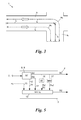
- Fig. 1 shows a road network 1, in the form of a digital road map 1 'of a network graph of road segments s 1 , s 2 , ..., s k , generally s modeled.
- An exemplary vehicle 2 carries an onboard unit (OBU) 3 which is capable of locating itself in the road network 1.
- the OBU 3 has for this purpose in addition to a microprocessor 4 and a memory 5 via a satellite navigation receiver 6 ( Fig. 2 ), with which it receives navigation signals 7 of a global navigation satellite system (GNSS) such as GPS, GLONASS, GALILEO or the like, and continuously obtains measurements of its own position (position fixes) p 1 , p 2 ,. .., generally p i , generated.
- GNSS global navigation satellite system
- the OBU 3 could also determine its position measurement values p i in another way, for example by means of radio triangulation, cell identifier evaluation or the like in a public land mobile network (PLMN) such as a GSM, UMTS or other 3G / 4G / 5G -Network.
- PLMN public land mobile network
- the OBU 3 is further equipped with a transceiver 9, by means of which it can send the position measurements p i via a mobile network 10 of the type described to a toll center 11.
- the road segments s k which the vehicle 2 has traveled can be determined from the position data p i thus obtained by map matching with the digital road map 1 '.
- the map-matching could also be performed in one of the toll center 11 upstream, separate map matching server ("map-matching-proxy") or even in the OBU 3, when the digital road map is stored in its memory 5.
- the length 1 of the path traveled by the vehicle 2 in the road network 1 can then be calculated from the known segment lengths l k of the determined road segments s k stored in the digital road map 1 '.
- Fig. 3 illustrates one of the problems of such map-matching path length determination. Due to the limited resolution of digital road maps, which also often model multi-lane road sections only by a single road segment s k , the path lengths l a , l b of the paths l traveled on different lanes w a , w b from the therefor deposited in the road map 1 ' Segment lengths l 3 , l 4 from. The procedure outlined below overcomes this problem.
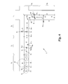
- Fig. 4 shows the process in overview and the Fig. 5 to 8 show the procedure in detail.
- the procedure of Fig. 4 to 8 can run both entirely in an OBU 3 and partly in an OBU 3 and partly in the toll center 11 and / or one of these upstream map matching proxy.
- the procedure of Fig. 4 is based on a special design of the OBUs 3, after p i in each case an associated quality measure q i of the position measurement value p i produce these at any position measuring value, ie two associated sequences ⁇ p i ⁇ (referred to below as F), and ⁇ q i ⁇ positional values p i and position quality measures q i or a sequence ⁇ (p i , q i ) ⁇ of Pairing position measurements p i and position quality measures q i .
- the Fig. 5 and 6 show various variants of the generation of a position quality measure q i for a position measurement value p i , wherein in each of the exemplary road segments s 1 - s 5 of Fig. 6 in each case a different variant is shown.
- the OBU 3 uses a satellite navigation receiver 6, which itself (“intrinsic") to each position measurement value p i also provides a measurement error or spread range value b i , which in the simplest case directly as the basis for the Position quality measure q i can serve, for example in the form q i ⁇ 1 / b i .
- Such scattering range values b i can be, for example, the values so-called DOP ("dilution of precision"), PDOP ("positional DOP"), TDOP ("time DOP”), GDOP ("geometric DOP”) or preferably HDOP ("horizontal DOP").
- DOP decilation of precision
- PDOP positional DOP
- TDOP time DOP
- GDOP geometric DOP
- HDOP horizontal DOP
- the scattering range value b i could be generated intrinsically, for example by the current receivable base stations of the mobile network 10 or the current localization accuracy of corresponding mobile network services ("location based services").
- FIG. 1 schematically shows such a direct use of the scattering range values b i of the receivers 6, 9 for the generation of the position quality measures q i in a block 13.
- a second variant of the generation of the position quality measures q i is illustrated.
- the satellite navigation receiver 6 supplies to each position measurement value p j in each case also a current motion vector v j (see path 14 in Fig. 5 ), including the direction and speed g j of the OBU 3 and possibly also its acceleration, which values of commercially available satellite navigation receivers 6 can be determined by means of Doppler measurements on the received satellite navigation signal 7 with particularly high accuracy.
- Commercially available mobile radio receivers 9 could also determine such a motion vector v j on the basis of Doppler measurements on the signals received from surrounding base stations.
- the motion vector v j could also be determined additionally or exclusively by an inertial measurement unit (IMU) in conjunction with, for example, an electronic compass system.
- IMU inertial measurement unit
- an expected value e j + 1 for the respective next position measurement value p j + 1 of the sequence F or ⁇ p i ⁇ can be estimated (extrapolated) using the current motion vector v j , and the deviation ⁇ j + 1 of the next position measurement value p j + 1 from its expected value e j + 1 represents - assuming that eg a Doppler-determined motion vector v j has very high accuracy - a spread range measure which is used as the basis for the calculation of the position quality measure q j + 1 of the position measurement value p j + 1 in block 13, eg in the form q j + 1 ⁇ 1 / ⁇ j + 1 .
- the OBU 3 could also receive motion values m j from a vehicle sensor of the vehicle 2, eg a speed or inertial sensor, tachometer, odometer, tachograph or the like, see path 15 in FIG Fig. 5 which can also be used to determine an expected value e j + 1 for the next position measurement value p j + 1 and thus the deviation ⁇ j + 1 and the position quality measure q j + 1 .
- a vehicle sensor of the vehicle 2 eg a speed or inertial sensor, tachometer, odometer, tachograph or the like, see path 15 in FIG Fig. 5 which can also be used to determine an expected value e j + 1 for the next position measurement value p j + 1 and thus the deviation ⁇ j + 1 and the position quality measure q j + 1 .
- an expected value e l + 1 is formed for a next position measurement value p l + 1 by extrapolation from previous position readings ..., p l-2 , p l-1 , p l and again the deviation ⁇ l + 1 of the Position reading p l + 1 determined.
- the interpolation and extrapolation can p of the sequence F are performed i are each also based on two or more forward-or ENGAGED ligand measured position values, and both linear interpolation and extrapolation as well as higher-order ( “wavelet-fitting", “spline fitting ”) can be considered and in a corresponding interpolator or extrapolator 16 of Fig. 5 be executed.
- the corresponding position quality measures q i (here: q k , q l ) can then be determined again in block 13, eg in the form q k ⁇ 1 / ⁇ k and q l ⁇ 1 / ⁇ l ,
- a variant is shown in which the distance or the deviation ⁇ m from the nearest road segment s k , here s 5 , is determined for each position measurement value p m by map-matching comparison with the digital road map 1 '.
- map-matching may proceed from block 17 in the OBU 3; in the case of a "thin-client” OBU, this step can be outsourced to an external map-matching proxy or the toll center 11. From the deviation ⁇ m , the position quality measure q m ⁇ 1 / ⁇ m for the position measurement value p m can then be determined again in the block 13.
- the values obtained via the paths 12 and 15 - 17 could optionally also be evaluated in multiple stages in block 13, in order to produce the quality measure q i , for example firstly with the aid of the scatter range values b i and, if these are sufficiently small, then on the basis of the expected values e i , e j , e k , e l .
- the position of quality measures could q i for different position readings p i are generated differently, eg if present during the GNSS positioning DOP values are not created when interim cellular location, or the location of quality measures q i are formed on the basis of manufacturer-specific quality indicators, the commercial GNSS receivers can generate.
- a first step 18 of the method successive segments or sets S 1 , S 2 ,..., generally S n , are produced from the sequences ⁇ p i ⁇ and ⁇ q i ⁇ generated by the OBU 3 of position measurement values and associated position quality measures. taken from position readings, u.zw. such that position measurement values p i whose position quality measures q i do not reach or fall below a predetermined first threshold value ⁇ 1 are not included in the sentences S n , ie they are not taken into account.
- Fig. 7 shows the result of step 18 for the exemplary position measurement values of Fig. 6 ,
- the extraction of the sets S n - and the respectively associated sets ⁇ q i ⁇ n of position quality measures q i - from the sequences ⁇ p i ⁇ and ⁇ q i ⁇ may in particular be such that adjacent sets S n succeed one another without overlapping, even if this is not mandatory. Also, it is not obligatory that the sentences S n approximately follow the road segments s k , this is in the Fig. 6 and 7 just shown for a better overview.
- the extraction (“segmentation and extraction”) of the sets S n in step 18 can be completely detached from the segmentation of the road network 1 in the digital road map 1 ', even if an approximate reference to the road segments s k not only for that in the road segment s 5 shown map-matching for determining the distance ⁇ m but also for the further steps of the method for determining the distance covered by the vehicle 2 path is favorable.
- step 18 sets S n of the threshold value ⁇ 1 border position measuring values p i are then - together with the sets S n associated position quality measures ⁇ q i ⁇ n - supplied to a step 19 in which for each set S n a Satztownsease Q n is determined, u.zw. in the following way.
- the sentence quality measure Q n is determined from the respective position quality measures q i of the position measurement values p i contained in the sentence S n , eg as an average or weighted sum thereof, for which all methods known in mathematics or statistics are suitable for linking measured values.
- the sentence quality measure Q n is formed only from the number A of position readings p i recorded in the set S n , eg the absolute number of position readings p i in the set S n or a "relative" number relative to the original position readings p i of the sequence F, ie as the ratio of the numbers of the set S n considered position measuring values p i to the sum of the set S n taken into account and considered non-position-measuring values p i. There may also be a minimum number of position readings p i are specified in the set S n , below which the sentence quality measure Q n is set to zero.
- the sets S n and their sentence quality measures Q n are subsequently fed to a comparison step 20, in which the sentence quality measure Q n of each sentence S n is compared with a predetermined second threshold value ⁇ 2 . If the sentence quality measure Q n exceeds the second threshold value ⁇ 2 , ie if the quantity or total quality of the position measurement values p i of the set S n is sufficiently good, a branch is made to a calculation step 21 (branch "y") in which the distance traveled by the vehicle 2 Path directly from the mutual distances a i of the successive position measurement values p i of the set S n is determined ("direct calculation", DC).
- the distances a 1 , a 2 and a 3 can be determined from the geometric distances of the position measurement values p 1 , p 2 , p 4 and p 5 itself, ie a i ⁇ (p i + 1 - p i ).
- the onboard unit 3 has also generated an associated pair (g i , t i ) of velocity g i and measurement time t i for each position measurement value p i by means of the satellite navigation receiver 6, the distances a 1 , a 2 and a 3 can alternatively also be determined from the speeds g 1 , g 2 and g 4 and the respective differences of the measurement times t 1 , t 2 , t 4 and t 5 of the position measurement values p 1 , p 2 , p 4 and p 5 , ie in the form a i ⁇ g i ⁇ (t i + 1 -t i ).
- the sentence quality measure Q 1 of the sentence S 1 was formed in the present example as the average of the position quality measures q i of the position measurement values p i contained in the sentence S 1 .
- the lengths l 3 and l 4 are determined for the sets S 3 and S 4 .
- the length l 2 or l 4 of the distance traveled by the vehicle 2 in the road segment s 2 or s 5 and set S 2 or S 5 is achieved by map matching (map matching) from those stored in the digital road map 1 ' Segment lengths l 2 and l 5 of the road segments s 2 and s 5 determined.
- map matching maps the position measurement values p i of the set S n associated with the or the respective nearest road segment (s) s k and their segment length (n) l k selected from the road map 1 '.
- the map-matching step 22 may be performed either in the OBU 3 (in the case of thick-client OBUs) or externally (in the case of thin-client OBUs), depending on the type of OBU 3.
- the position measurement values p i are generated much more frequently and thus as a denser sequence F than in the Fig. 1 and 6 to 8 has been simplified for clarity.
- the road segments s k may be different from toll segments of existing road toll systems and in particular have small segment lengths l k .
- the sentences S n are expediently matched to the road segments s k such that in the region of boundaries between two road segments s k , s k + 1 two sets S n , S n + 1 adjoin one another; In the case of a dense sequence F of position measured values p i , any deviations at the boundaries between road segments s k , s k + 1 are negligible or average over longer path lengths 1.
Abstract
Description
Die vorliegende Erfindung betrifft ein Verfahren zum Ermitteln der Länge eines von einem Fahrzeug zurückgelegten Wegs unter Verwendung einer vom Fahrzeug mitgeführten Onboard-Unit, welche eine Folge von Messwerten ihrer eigenen Position erzeugt.The present invention relates to a method for determining the length of a vehicle-traveled path using an on-board unit carried by the vehicle, which generates a series of measurements of its own position.
Onboard-Units (OBUs) werden insbesondere in Straßenmautsystemen eingesetzt, um von einem die OBU mitführenden Fahrzeug befahrene Wege ermitteln und anschließend vermauten zu können. Dazu lokalisiert sich eine OBU beispielsweise in einem Satellitennavigationssystem (global navigation satellite system, GNSS) oder in einem terrestrischen Mobilfunknetz mit mehreren ortsfesten Sendeempfängern selbst und erzeugt so eine Folge von Positionsmesswerten ("position fixes"). Jeder der erzeugten Positionsmesswerte unterliegt Messungenauigkeiten, weshalb die erzeugte Folge einer Nachbearbeitung bedarf.On-board units (OBUs) are used in particular in road toll systems in order to be able to determine routes which are traveled by a vehicle carrying the OBU and then to be able to conquer them. For this purpose, an OBU locates itself for example in a satellite navigation system (GNSS) or in a terrestrial mobile radio network with a plurality of fixed transceivers itself and thus generates a sequence of position readings ("position fixes"). Each of the generated position measurement values is subject to measurement inaccuracies, which is why the generated sequence requires post-processing.
Zur Nachbearbeitung ist es bekannt, die erzeugten Positionsmesswerte mit einer das Straßennetz modellierenden digitalen Straßenkarte zu vergleichen ("map-matching"). Dabei werden die jeweils nächstliegenden Straßensegmente als befahren ermittelt. Je nach Bauart sendet die OBU dazu entweder die Positionsmesswerte an eine Zentrale des Straßenmautsystems, wo das map-matching erfolgt ("thin-client-OBU"), oder die digitale Straßenkarte ist in der OBU selbst abgelegt, wo auch das map-matching durchgeführt wird ("thick-client-OBU").For post-processing, it is known to compare the generated position measured values with a digital road map modeling the road network ("map-matching"). The nearest road segments are determined to be traveled. Depending on the design, the OBU either sends the position readings to a center of the road toll system, where the map-matching takes place ("thin-client OBU"), or the digital road map is stored in the OBU itself, where the map-matching performed becomes ("thick-client-OBU").
Map-matching-Verfahren haben jedoch den Nachteil, dass die Genauigkeit der Weglängenermittlung durch die Segmentauflösung der digitalen Straßenkarte beschränkt ist. Die Längen der von einem Fahrzeug tatsächlich zurückgelegten Wege weichen häufig von den Längen der digital modellierten Straßensegmente ab: So ist beispielsweise im Bereich von Kurven, Kreuzungen oder Kreisverkehren der tatsächlich befahrene Weg abhängig von der Fahrtrichtung des Fahrzeugs, während die Segmentlängen der digitalen Straßenkarte in der Regel davon unabhängig modelliert sind.However, map-matching methods have the disadvantage that the accuracy of the path length determination is limited by the segment resolution of the digital road map. The lengths of the paths actually traveled by a vehicle often deviate from the lengths of the digitally modeled road segments: for example, in the area of curves, intersections or roundabouts, the actual traveled route depends on the direction of travel of the vehicle, while the segment lengths of the digital Road map are usually modeled independently of it.
Anderseits wäre es auch problematisch, die Weglängen auf der Grundlage der Positionsmesswerte zu ermitteln, da die häufigen Ungenauigkeiten der Positionsmesswerte einer verlässlichen, robusten Weglängenermittlung entgegenstehen.On the other hand, it would also be problematic to determine the path lengths on the basis of the position measurement values, since the frequent inaccuracies of the position measurement values preclude a reliable, robust path length determination.
Die Erfindung setzt sich zum Ziel, ein Verfahren zum Ermitteln der Länge eines von einem Fahrzeug zurückgelegten Wegs zu schaffen, welches eine höhere Genauigkeit als bisher bekannte Systeme bei gleichzeitiger Robustheit gegenüber Positionsmessungenauigkeiten aufweist.The invention has for its object to provide a method for determining the length of a path traveled by a vehicle, which has a higher accuracy than previously known systems, while being robust against position measurement inaccuracies.
Dieses Ziel wird mit einem Verfahren der genannten Art unter Verwendung einer Onboard-Unit erreicht, welche eine Folge von Messwerten ihrer eigenen Position und für jeden Positionsmesswert der Folge ein zugehöriges Positionsqualitätsmaß erzeugt, umfassend:
- Entnehmen eines Satzes aufeinanderfolgender Positionsmesswerte aus der Folge unter Nichtberücksichtigung jener Positionsmesswerte, deren Positionsqualitätsmaß einen vorgegebenen ersten Schwellwert unterschreitet,
- Ermitteln eines Satzqualitätsmaßes anhand der Anzahl der Positionsmesswerte des Satzes oder anhand ihrer Positionsqualitätsmaße, und
- wenn das Satzqualitätsmaß einen vorgegebenen zweiten Schwellwert überschreitet: Ermitteln der Weglänge aus den gegenseitigen Abständen aufeinanderfolgender Positionsmesswerte des Satzes,
- andernfalls: Ermitteln der Weglänge unter Verwendung einer digitalen Straßenkarte, die sich aus Straßensegmenten jeweils bekannter Segmentlänge zusammensetzt, durch Zuordnen der Positionsmesswerte des Satzes zu zumindest einem Straßensegment und Ermitteln der Weglänge aus der Segmentlänge dieses zumindest einen Straßensegments.
- Extracting a set of successive position measurement values from the sequence, ignoring those position measurement values whose position quality measure falls below a predetermined first threshold value,
- Determining a sentence quality measure based on the number of position measurements of the sentence or their position quality measures, and
- if the sentence quality measure exceeds a predetermined second threshold: determining the path length from the mutual distances of successive position measurement values of the sentence,
- otherwise: determining the pathlength using a digital road map composed of road segments of known segment length respectively by associating the position readings of the set with at least one road segment and determining the pathlength from the segment length of that at least one road segment.
Das Verfahren der Erfindung beruht auf einem zweistufigen Qualitätsvergleich. In einer ersten Stufe werden Positionsmesswerte hoher Positionsqualität in einen Satz übernommen und dabei "schlechte" Positionsmesswerte ausgeschieden; daraufhin wird in einer zweiten Stufe die Qualität des gesamten Satzes beurteilt: Ist diese hoch, so erfolgt die Ermittlung der Weglänge unmittelbar auf Grundlage der realen, "guten" Positionsmesswerte des Satzes und ist damit größtmöglich präzise. Wenn die Satzqualität nicht ausreicht, wird für diesen Satz ein Straßensegment durch map-matching ermittelt und zur Bestimmung der Weglänge herangezogen. Wird das Verfahren wiederholt für aufeinanderfolgende Sätze von Positionsmesswerten durchgeführt, so ergibt sich für eine über mehrere Sätze bzw. Segmente aufsummierte Gesamtlänge des zurückgelegten Wegs eine besonders hohe Genauigkeit durch die direkte Verwendung der "guten" Positionsmesswerte bei gleichzeitiger erhöhter Robustheit des Verfahrens gegenüber "schlechten" Positionsmesswerten in einzelnen Straßensegmenten durch das dort angewendete map-matching-Verfahren.The method of the invention is based on a two-stage quality comparison. In a first step, position readings become high position quality taken over in a sentence and thereby eliminated "bad" position measured values; then, in a second step, the quality of the entire sentence is evaluated: if this is high, the determination of the path length is made directly on the basis of the real, "good" position measured values of the sentence and is therefore as precise as possible. If the sentence quality is not sufficient, a road segment is determined for this sentence by map-matching and used to determine the path length. If the method is carried out repeatedly for successive sets of position measurement values, the result for a total length of the traveled path added up over several sentences or segments is a particularly high accuracy due to the direct use of the "good" position measurement values while at the same time increasing the robustness of the method compared to "bad" ones. Position measurements in individual road segments by the map-matching method used there.
In einer vorteilhaften Ausführungsform der Erfindung wird das Satzqualitätsmaß aus den Positionsqualitätsmaßen des Satzes als Durchschnitt derselben ermittelt. So findet das Positionsqualitätsmaß jedes der im Satz berücksichtigten Positionsmesswerte Eingang in das Satzqualitätsmaß. Die Entscheidung, ob die Positionsmesswerte für die Weglängenermittlung herangezogen werden sollen oder das robustere map-matching-Verfahren angewendet werden soll, wird somit genau anhand der relevanten Positionsqualitätsmaße der berücksichtigten Positionsmesswerte getroffen.In an advantageous embodiment of the invention, the sentence quality measure is determined from the position quality measures of the sentence as an average thereof. Thus, the position quality measure of each of the position measurement values taken into account in the sentence is included in the sentence quality measure. The decision as to whether the position measurement values are to be used for the determination of the path length or the more robust map-matching method is to be applied is thus made precisely on the basis of the relevant position quality measures of the taken position measurement values.
Alternativ dazu kann das Satzqualitätsmaß als Verhältnis der Anzahlen von im Satz berücksichtigten Positionsmesswerten zur Summe aus berücksichtigten plus nicht-berücksichtigten Positionsmesswerten ermittelt werden. Dadurch werden indirekt auch Messungenauigkeiten der nicht-berücksichtigten Positionsmesswerte mitbetrachtet und bilden so eine breitere Entscheidungsgrundlage. Außerdem wird das Satzqualitätsmaß durch einen solchen einfachen Vergleich der Anzahlen ressourcenschonend und rasch ermittelt.Alternatively, the sentence quality measure may be determined as the ratio of the numbers of position measurement values taken into account in the sentence to the sum of considered plus non-considered position measurement values. As a result, measurement inaccuracies of the unaccounted position measured values are also indirectly taken into account and thus form a broader basis for the decision. In addition, the sentence quality measure is replaced by a such a simple comparison of the numbers resource-saving and quickly determined.
Falls gewünscht, können die Positionsmesswerte mittels eines Mobilfunkempfängers der Onboard-Unit durch Ortung in einem terrestrischen Mobilfunknetz erzeugt werden. Besonders vorteilhaft ist es, wenn die Positionsmesswerte mittels eines Satellitennavigationsempfängers der Onboard-Unit durch Ortung in einem Satellitennavigationssystem (global navigation satellite system, GNSS) erzeugt werden.If desired, the position measurement values can be generated by means of a mobile radio receiver of the onboard unit by locating in a terrestrial mobile radio network. It is particularly advantageous if the position measurement values are generated by means of a satellite navigation receiver of the on-board unit by locating in a navigation satellite system (GNSS).
Die Bestimmung des Positionsqualitätsmaßes ist in verschiedenen Varianten möglich, die auch miteinander kombiniert oder nacheinander angewendet werden können. Eine erste Ausführungsform, die speziell für GNSS-basierte OBUs geeignet ist, besteht darin, dass der Satellitennavigationsempfänger zu jedem Positionsmesswert einen zugehörigen DOP-Wert ("dilution of precision"), bevorzugt HDOP-Wert ("horizontal dilution of precision"), als Grundlage für dessen Positionsqualitätsmaß ausgibt. DOP- und HDOP-Werte werden von vielen handelsüblichen Satellitennavigationsempfängern nativ zu jedem Positionsmesswert bereitgestellt und geben die geometrischen Verhältnisse der aktuellen Satellitenkonstellation an, die hier als Basis eines möglichen Streubereichs des jeweiligen Positionsmesswerts dienen.The determination of the position quality measure is possible in different variants, which can also be combined with each other or applied one after the other. A first embodiment, which is particularly suitable for GNSS-based OBUs, is that the satellite navigation receiver for each position measurement value has an associated dilution of precision (DOP) value, preferably horizontal dilution of precision (HDOP) Basis for its position quality measure. DOP and HDOP values are provided by many commercially available satellite navigation receivers natively to each position measurement and indicate the geometric relationships of the current satellite constellation, which serve as the basis for a possible range of variation of the respective position measurement value.
In einer alternativen oder ergänzenden Ausführungsform wird das Positionsqualitätsmaß eines Positionsmesswerts in Abhängigkeit von dessen Abstand zu einem nächstliegenden Straßensegment der digitalen Straßenkarte erzeugt. Eine solche Vorgehensweise entspricht einem vereinfachten map-matching-Verfahren, in dem keine komplexe Plausibilitätsprüfung anhand benachbarter Positionsmesswerte durchgeführt wird, sondern lediglich der Abstand zum nächstliegenden Straßensegment bestimmt wird. Somit findet die Robustheit des map-matching-Verfahrens bereits bei der Erzeugung des Positionsqualitätsmaßes Eingang in das erfindungsgemäße Verfahren, sodass z.B. einzelne weit abliegende Positionsmesswerte ("Ausreißer" bzw. "outlier") nicht berücksichtigt werden. In thick-client-OBUs, wo die digitale Straßenkarte in der OBU vorliegt, kann diese Ausführungsform direkt umgesetzt werden und ist deshalb besonders vorteilhaft. Jedoch können dazu auch thin-client-OBUs eingesetzt werden, die diesen Schritt an ein externes map-matching-System auslagern.In an alternative or supplementary embodiment, the position quality measure of a position measurement value is generated as a function of its distance from a nearest road segment of the digital road map. Such a procedure corresponds to a simplified map-matching method, in which no complex plausibility check is carried out on the basis of adjacent position measured values, but only the distance to the nearest road segment is determined. Thus, the robustness of the map-matching method already in the generation of the position quality measure input into the method according to the invention, so that, for example, individual far away position measured values ("outlier" or "outlier") are not taken into account. In thick-client OBUs where the digital Road map in the OBU, this embodiment can be implemented directly and is therefore particularly advantageous. However, thin-client OBUs can be used to offload this step to an external map-matching system.
In einer weiteren alternativen oder zusätzlichen Ausführungsform wird das Positionsqualitätsmaß eines Positionsmesswerts in Abhängigkeit von dessen Abstand zu einem Erwartungswert erzeugt, welcher für den genannten Positionsmesswert durch Interpolation aus benachbarten Positionsmesswerten der Folge gebildet wird. Einzelne "Ausreißer" können so auch ohne map-matching aus dem Verfahren ausgeschieden werden. Dabei können auch mehr als zwei benachbarte Positionsmesswerte zur Interpolation herangezogen werden, insbesondere für Interpolationen höherer (nicht-linearer) Ordnung, was die Treffsicherheit erhöht.In a further alternative or additional embodiment, the position quality measure of a position measurement value is generated as a function of its distance to an expected value, which is formed for said position measurement value by interpolation from adjacent position measurement values of the sequence. Individual "outliers" can be eliminated from the procedure without map-matching. In this case, more than two adjacent position measured values can also be used for the interpolation, in particular for interpolations of higher (non-linear) order, which increases the accuracy.
Alternativ kann das Positionsqualitätsmaß eines Positionsmesswerts in Abhängigkeit von dessen Abstand zu einem Erwartungswert erzeugt werden, welcher für den genannten Positionsmesswert durch Extrapolation aus vorhergehenden Positionsmesswerten der Folge gebildet wird. Nachfolgende Positionsmesswerte müssen dazu, anders als bei der Interpolation, noch nicht bekannt sein, sodass sich diese Variante besonders für eine Echtzeit-Implementierung eignet. Auch hier kann mehr als ein vorhergehender Positionsmesswert zur Extrapolation herangezogen werden, insbesondere für Extrapolationen höherer (nicht-linearer) Ordnung oder z.B. bei Verwendung eines Kalman-Filters zur Extrapolation, was wieder die Treffsicherheit erhöht.Alternatively, the position quality measure of a position measurement value can be generated as a function of its distance to an expected value, which is formed for the named position measurement value by extrapolation from previous position measurement values of the sequence. Subsequent position readings, unlike interpolation, do not need to be known yet, so this variant is especially suited for real-time implementation. Again, more than one previous position measurement may be used for extrapolation, especially for extrapolations of higher (non-linear) order or e.g. when using a Kalman filter for extrapolation, which again increases the accuracy.
Viele Satellitennavigationsempfänger können heute mit hoher Genauigkeit bereits nativ auch ihre Geschwindigkeit und Bewegungsrichtung sowie ihre Beschleunigung bestimmen. In solchen Fällen ist es besonders günstig, wenn der Satellitennavigationsempfänger zu jedem Positionsmesswert einen zugehörigen Bewegungsvektor ausgibt, welcher zur Extrapolation des Erwartungswerts herangezogen wird. Ein solcher aus Geschwindigkeit und Bewegungsrichtung - gegebenenfalls unter Zuhilfenahme des Werts für die Beschleunigung - gebildeter Bewegungsvektor lässt den Erwartungswert für den folgenden Positionsmesswert besonders präzise abschätzen und liefert einen guten Anhaltspunkt für das Erzeugen des Positionsqualitätmaßes.Many satellite navigation receivers can now determine natively their speed and direction of motion as well as their acceleration with high accuracy. In such cases, it is particularly advantageous if the satellite navigation receiver outputs an associated motion vector for each position measurement value, which is used to extrapolate the expected value. One of speed and direction of movement - possibly with the help of the value for acceleration - formed motion vector makes the expectation value for the following position measurement value very precisely estimate and provides a good indication for generating the position quality measure.
Alternativ dazu kann die Onboard-Unit zu jedem Positionsmesswert einen Bewegungsmesswert von einem Fahrzeugsensor empfangen, welcher zur Extrapolation des Erwartungswerts herangezogen wird. Der Bewegungsmesswert kann dabei von einem Geschwindigkeits- oder Trägheitssensor, gegebenenfalls auch von einem Tachograph des Fahrzeugs gesendet werden und auch eine Kombination der Messwerte solcher Sensoren sein. Dies führt ebenso zu einer präzisen Abschätzung des Erwartungswerts, und zwar ohne von einem GNSS abhängig zu sein.Alternatively, the onboard unit may receive for each position measurement value a movement measurement value from a vehicle sensor, which is used to extrapolate the expected value. The measured movement value can be transmitted by a speed or inertial sensor, if appropriate also by a tachograph of the vehicle, and also be a combination of the measured values of such sensors. This also leads to a precise estimate of the expected value, without being dependent on a GNSS.
Aufeinanderfolgende Sätze von Positionsmesswerten könnten einander überlappen. Um ein rascheres Ermitteln der Weglänge zu begünstigen, werden aufeinanderfolgende Sätze von Positionsmesswerten bevorzugt überlappungsfrei aus der Folge von Positionsmesswerten entnommen, da so die Weglänge mit der geringsten Anzahl von Sätzen rasch und lückenlos ermittelbar ist.Successive sets of position measurements could overlap one another. In order to favor a more rapid determination of the path length, successive sets of position measurement values are preferably taken without overlapping from the sequence of position measurement values, since the path length with the smallest number of sentences can thus be determined quickly and completely.
In einer vorteilhaften Variante der Erfindung werden die gegenseitigen Abstände aus den Positionsmesswerten selbst ermittelt. In einer alternativen Variante dazu erzeugt die Onboard-Unit für jeden Positionsmesswert ein zugehöriges Paar von Geschwindigkeit und Messzeitpunkt, und die gegenseitigen Abstände jeweils zweier aufeinanderfolgender Positionsmesswerte werden aus der Geschwindigkeit am ersten der beiden Positionsmesswerte und der Differenz der Messzeitpunkte der beiden Positionsmesswerte ermittelt. Da gerade in Satellitennavigationsempfängern besonders präzise Werte für Geschwindigkeit und Zeit erzeugt werden, ermöglicht letztere Variante eine besonders genaue Ermittlung der Abstände aufeinanderfolgender Positionsmesswerte.In an advantageous variant of the invention, the mutual distances are determined from the position measured values themselves. In an alternative variant, the onboard unit generates an associated pair of speed and measurement time for each position measurement value, and the mutual distances between two successive position measurement values are determined from the speed at the first of the two position measurement values and the difference between the measurement times of the two position measurement values. Since especially in satellite navigation receivers particularly precise values for speed and time are generated, the latter variant allows a particularly accurate determination of the distances of successive position measured values.
Die Erfindung wird nachfolgend anhand von in den beigeschlossenen Zeichnungen dargestellten Ausführungsbeispielen näher erläutert. In den Zeichnung zeigen:
-
Fig. 1 einen Ausschnitt eines durch eine digitale Straßenkarte modellierten Straßennetzes schematisch in der Draufsicht; -
Fig. 2 eine zur Verwendung im erfindungsgemäßen Verfahren geeignete Onboard-Unit in einem schematischen Blockschaltbild; -
Fig. 3 eine der Abbiegungen des Straßennetzes vonFig. 1 vergrößert im Detail; -
Fig. 4 ein Flussdiagramm des Verfahrens der Erfindung zur Ermittlung eines von einem Fahrzeug in dem Straßennetz vonFig. 1 zurückgelegten Wegs; - die
Fig. 5 und6 verschiedene Varianten der Erzeugung eines Positionsqualitätsmaßes für einen Positionsmesswert einmal in funktioneller Blockschaltbildform (Fig. 5 ) und einmal anhand beispielhafter Positionsmesswerte im Straßennetz (Fig. 6 ); -
Fig. 7 den Schritt des Entnehmens von Sätzen von Positionsmesswerten entsprechend den Varianten vonFig. 5 und6 im Detail; und -
Fig. 8 die satzqualitätsabhängige Weglängenermittlung anhand des Beispiels derFig. 5 bis 7 im Detail.
-
Fig. 1 a section of a modeled by a digital road map road network schematically in plan view; -
Fig. 2 an on-board unit suitable for use in the method according to the invention in a schematic block diagram; -
Fig. 3 one of the turns of the road network ofFig. 1 enlarged in detail; -
Fig. 4 a flow chart of the method of the invention for detecting one of a vehicle in the road network ofFig. 1 traveled way; - the
Fig. 5 and6 different variants of the generation of a position quality measure for a position measurement value once in functional block diagram form (Fig. 5 ) and once using exemplary position measurements in the road network (Fig. 6 ); -
Fig. 7 the step of extracting sets of position measurements according to the variants ofFig. 5 and6 in detail; and -
Fig. 8 the set quality - dependent determination of the path length on the basis of the example ofFig. 5 to 7 in detail.
Gemäß
Das Verfahren von
Wie im Straßensegment s1 von
Wenn die OBU 3 anstelle (oder zusätzlich) zu dem Satellitennavigationsempfänger 6 einen Mobilfunknetz-Sendeempfänger 9 zur Positionsbestimmung einsetzt, könnte der Streubereichswert bi beispielsweise auch von diesem intrinsisch erzeugt werden, z.B. anhand der aktuell empfangbaren Basisstationen des Mobilfunknetzes 10 oder der aktuellen Lokalisierungsgenauigkeit entsprechender Mobilfunknetzdienste ("location based services").If the
Pfad 12 in
Im Straßensegment s2 von
Ausgehend von einem aktuellen Positionsmesswert pj kann anhand des aktuellen Bewegungsvektors vj ein Erwartungswert ej+1 für den jeweils nächsten Positionsmesswert pj+1 der Folge F bzw. {pi} geschätzt (extrapoliert) werden, und die Abweichung δj+1 des nächsten Positionsmesswerte pj+1 von seinem Erwartungswert ej+1 stellt - unter der Annahme, dass z.B. ein Dopplerbestimmter Bewegungsvektor vj sehr hohe Genauigkeit hat - wieder ein Streubereichsmaß dar, das als Grundlage für die Berechnung des Positionsqualitätsmaßes qj+1 des Positionsmesswerts pj+1 in Block 13 dienen kann, z.B. in der Form qj+1 ≙ 1/δj+1.Starting from a current position measurement value p j , an expected value e j + 1 for the respective next position measurement value p j + 1 of the sequence F or {p i } can be estimated (extrapolated) using the current motion vector v j , and the deviation δ j + 1 of the next position measurement value p j + 1 from its expected value e j + 1 represents - assuming that eg a Doppler-determined motion vector v j has very high accuracy - a spread range measure which is used as the basis for the calculation of the position quality measure q j + 1 of the position measurement value p j + 1 in
Alternativ (oder zusätzlich) zu dem Bewegungsvektor vj könnte die OBU 3 auch Bewegungswerte mj von einem Fahrzeugsensor des Fahrzeugs 2, z.B. einem Geschwindigkeits- oder Trägheitssensor, Tachometer, Odometer, Fahrtenschreiber od. dgl., empfangen, siehe Pfad 15 in
Anhand der Straßensegmente s3 und s4 von
Die Inter- bzw. Extrapolation kann jeweils auch anhand von zwei oder mehreren voraus- bzw. nachgehenden Positionsmesswerten pi der Folge F durchgeführt werden, und sowohl lineare Inter- und Extrapolationen als auch solche höherer Ordnung ("wavelet-fitting", "spline fitting") können in Betracht gezogen und in einem entsprechenden Inter- bzw. Extrapolierer 16 von
Aus den Abweichungen δk, δl können dann wieder im Block 13 die entsprechenden Positionsqualitätsmaße qi (hier: qk, ql) ermittelt werden, z.B. in der Form qk ≙ 1/δk und ql ≙ 1/δl.From the deviations δ k , δ l , the corresponding position quality measures q i (here: q k , q l ) can then be determined again in
Im Straßensegment s5 von
Es versteht sich, dass das Positionsqualitätsmaß qi im Block 13 auch aus einer beliebigen Funktion F, z.B. gewichteten Summe, der Streubereichswerte bi und Abweichungen δj, δk, δl, δm berechnet werden kann, d.h. qi = f (bi, δj, δk, δl, δm).It is understood that the position quality measure q i in
Die über die Pfade 12 und 15 - 17 erhaltenen Werte könnten in Block 13 gegebenenfalls auch mehrstufig ausgewertet werden, um das Qualitätsmaß qi zu erzeugen, z.B. zunächst mithilfe der Streubereichswerte bi und, wenn diese ausreichend klein sind, anschließend anhand der Erwartungswerte ei, ej, ek, el. Auch könnten die Positionsqualitätsmaße qi für verschiedene Positionsmesswerte pi unterschiedlich erzeugt werden, z.B. wenn während der GNSS-Ortung DOP-Werte vorliegen, die bei zwischenzeitlicher Mobilfunk-Ortung nicht erstellt werden, oder die Positionsqualitätsmaße qi werden anhand herstellerspezifischer Qualitätsindikatoren gebildet, die handelsübliche GNSS-Empfänger erzeugen können.The values obtained via the
Zurückkommend auf
Wie in
Die Entnahme der Sätze Sn - und der jeweils zugehörigen Sätze {qi}n von Positionsqualitätsmaßen qi - aus den Folgen {pi} und {qi} kann insbesondere so erfolgen, dass benachbarte Sätze Sn überlappungsfrei aufeinanderfolgen, auch wenn dies nicht zwingend ist. Auch ist es nicht obligat, dass die Sätze Sn annähernd den Straßensegmenten sk folgen, dies ist in den
Die in Schritt 18 entnommenen Sätze Sn von den Schwellwert σ1 überschreitenden Positionsmesswerten pi werden anschließend - gemeinsam mit den den Sätzen Sn zugeordneten Positionsqualitätsmaßen {qi}n - einem Verfahrensschritt 19 zugeführt, in welchem für jeden Satz Sn ein Satzqualitätsmaß Qn ermittelt wird, u.zw. in der folgenden Art und Weise.The samples taken in
In einer Ausführungsform wird das Satzqualitätsmaß Qn aus den jeweiligen Positionsqualitätsmaßen qi der im Satz Sn enthaltenen Positionsmesswerte pi ermittelt, z.B. als Durchschnitt oder gewichtete Summe derselben, wofür alle in Mathematik bzw. Statistik bekannten Verfahren zur Verknüpfung von Messwerten geeignet sind.In one embodiment, the sentence quality measure Q n is determined from the respective position quality measures q i of the position measurement values p i contained in the sentence S n , eg as an average or weighted sum thereof, for which all methods known in mathematics or statistics are suitable for linking measured values.
In einer vereinfachten Ausführungsform wird das Satzqualitätsmaß Qn lediglich aus der Anzahl A von in den Satz Sn aufgenommenen Positionsmesswerten pi gebildet, z.B. der absoluten Anzahl von Positionsmesswerten pi im Satz Sn oder einer "relativen" Anzahl bezogen auf die ursprünglichen Positionsmesswerte pi der Folge F, d.h. als Verhältnis der Anzahlen von im Satz Sn berücksichtigten Positionsmesswerten pi zur Summe aus im Satz Sn berücksichtigten und nicht-berücksichtigten Positionsmesswerten pi. Dabei kann auch eine Mindestanzahl von Positionsmesswerten pi im Satz Sn vorgegeben werden, unterhalb der das Satzqualitätsmaß Qn auf Null gesetzt wird.In a simplified embodiment, the sentence quality measure Q n is formed only from the number A of position readings p i recorded in the set S n , eg the absolute number of position readings p i in the set S n or a "relative" number relative to the original position readings p i of the sequence F, ie as the ratio of the numbers of the set S n considered position measuring values p i to the sum of the set S n taken into account and considered non-position-measuring values p i. There may also be a minimum number of position readings p i are specified in the set S n , below which the sentence quality measure Q n is set to zero.
Die Sätze Sn und ihre Satzqualitätsmaße Qn werden anschließend einem Vergleichsschritt 20 zugeführt, in welchem das Satzqualitätsmaß Qn jedes Satzes Sn mit einem vorgegebenen zweiten Schwellwert σ2 verglichen wird. Übersteigt das Satzqualitätsmaß Qn den zweiten Schwellwert σ2, ist also die Quantität oder Gesamt-Qualität der Positionsmesswerte pi des Satzes Sn ausreichend gut, wird zu einem Berechnungsschritt 21 verzweigt (Zweig "y"), in welchem der vom Fahrzeug 2 zurückgelegte Weg direkt aus den gegenseitigen Abständen ai der aufeinanderfolgenden Positionsmesswerte pi des Satzes Sn ermittelt wird ("direct calculation", DC).The sets S n and their sentence quality measures Q n are subsequently fed to a
Dies ist in
Die Abstände a1, a2 und a3 können dabei aus den geometrischen Abständen der Positionsmesswerte p1, p2, p4 und p5 selbst bestimmt werden, d.h. ai ≙ (pi+1 - pi). Hat die Onboard-Unit 3 z.B. mithilfe des Satellitennavigationsempfängers 6 für jeden Positionsmesswert pi auch ein zugehöriges Paar (gi, ti) von Geschwindigkeit gi und Messzeitpunkt ti erzeugt, so können die Abstände a1, a2 und a3 alternativ auch aus den Geschwindigkeiten g1, g2 und g4 und den jeweiligen Differenzen der Messzeitpunkte t1, t2, t4 und t5 der Positionsmesswerte p1, p2, p4 und p5 ermittelt werden, d.h. in der Form ai ≙ gi · (ti+1 - ti).The distances a 1 , a 2 and a 3 can be determined from the geometric distances of the position measurement values p 1 , p 2 , p 4 and p 5 itself, ie a i ≙ (p i + 1 - p i ). If, for example, the
Das Satzqualitätsmaß Q1 des Satzes S1 wurde im vorliegenden Beispiel als Durchschnitt der Positionsqualitätsmaße qi der im Satz S1 enthaltenen Positionsmesswerte pi gebildet. In gleicher Weise werden die Längen l3 und l4 für die Sätze S3 und S4 ermittelt.The sentence quality measure Q 1 of the sentence S 1 was formed in the present example as the average of the position quality measures q i of the position measurement values p i contained in the sentence S 1 . In the same The lengths l 3 and l 4 are determined for the sets S 3 and S 4 .
Erreicht im Vergleichsschritt 20 das Satzqualitätsmaß Qn den zweiten Schwellwert σ2 hingegen nicht, wird zu dem alternativen Berechnungsschritt 22 verzweigt (Zweig "n"), in dem der vom Fahrzeug 2 zurückgelegte Weg mittels map-matching ("MM") ermittelt wird. Dies ist wiederum in
Im Berechnungsschritt 22 wird die Länge l2 bzw. l4 des vom Fahrzeug 2 im Straßensegment s2 bzw. s5 und Satz S2 bzw. S5 zurückgelegten Wegs durch Kartenabgleich (map-matching) aus den in der digitalen Straßenkarte 1' hinterlegten Segmentlängen l2 und l5 der Straßensegmente s2 und s5 ermittelt. Dazu werden - wie bereits anhand von
Wenn das Verfahren von 
summiert werden. Die solcherart aufsummierte zurückgelegte Weglänge 1 hat eine höhere Genauigkeit als eine ausschließlich durch direct calculation (DC) 21 oder map-matching (MM) 22 berechnete Weglänge.If the procedure of
be summed up. The totaled
Es versteht sich, dass in der Praxis die Positionsmesswerte pi wesentlich häufiger und somit als dichtere Folge F erzeugt werden als es in den
Die Erfindung ist nicht auf die dargestellten Ausführungsformen beschränkt, sondern umfasst alle Varianten, Kombinationen und Modifikationen, die in den Rahmen der angeschlossenen Ansprüche fallen.The invention is not limited to the illustrated embodiments, but includes all variants, combinations and modifications that fall within the scope of the appended claims.
Claims (14)
Priority Applications (8)
| Application Number | Priority Date | Filing Date | Title |
|---|---|---|---|
| EP12180295.3A EP2698607B1 (en) | 2012-08-13 | 2012-08-13 | Method for calculating the distance travelled by a vehicle |
| SI201230105T SI2698607T1 (en) | 2012-08-13 | 2012-08-13 | Method for calculating the distance travelled by a vehicle |
| ES12180295.3T ES2525867T3 (en) | 2012-08-13 | 2012-08-13 | Procedure to determine the length of a route traveled by a vehicle |
| DK12180295.3T DK2698607T3 (en) | 2012-08-13 | 2012-08-13 | Procedure for determining the length of a line completed by a vehicle |
| PT121802953T PT2698607E (en) | 2012-08-13 | 2012-08-13 | Method for calculating the distance travelled by a vehicle |
| PL12180295T PL2698607T3 (en) | 2012-08-13 | 2012-08-13 | Method for calculating the distance travelled by a vehicle |
| CA2819322A CA2819322C (en) | 2012-08-13 | 2013-06-26 | Method for determining the length of a path traveled by a vehicle |
| US13/965,740 US9086279B2 (en) | 2012-08-13 | 2013-08-13 | Method for determining the length of a path traveled by a vehicle |
Applications Claiming Priority (1)
| Application Number | Priority Date | Filing Date | Title |
|---|---|---|---|
| EP12180295.3A EP2698607B1 (en) | 2012-08-13 | 2012-08-13 | Method for calculating the distance travelled by a vehicle |
Publications (2)
| Publication Number | Publication Date |
|---|---|
| EP2698607A1 true EP2698607A1 (en) | 2014-02-19 |
| EP2698607B1 EP2698607B1 (en) | 2014-10-01 |
Family
ID=47018033
Family Applications (1)
| Application Number | Title | Priority Date | Filing Date |
|---|---|---|---|
| EP12180295.3A Active EP2698607B1 (en) | 2012-08-13 | 2012-08-13 | Method for calculating the distance travelled by a vehicle |
Country Status (8)
| Country | Link |
|---|---|
| US (1) | US9086279B2 (en) |
| EP (1) | EP2698607B1 (en) |
| CA (1) | CA2819322C (en) |
| DK (1) | DK2698607T3 (en) |
| ES (1) | ES2525867T3 (en) |
| PL (1) | PL2698607T3 (en) |
| PT (1) | PT2698607E (en) |
| SI (1) | SI2698607T1 (en) |
Families Citing this family (3)
| Publication number | Priority date | Publication date | Assignee | Title |
|---|---|---|---|---|
| KR20160027739A (en) * | 2014-09-02 | 2016-03-10 | 현대모비스 주식회사 | Apparatus for estimating location vehicle and method thereof |
| US9921291B2 (en) * | 2016-04-07 | 2018-03-20 | Qualcomm Incorporated | Multi-tiered distance travelled estimator |
| CN108364456B (en) * | 2018-01-12 | 2021-03-09 | 山东高速信息工程有限公司 | Method, storage medium, device and system for determining highway pile number |
Citations (3)
| Publication number | Priority date | Publication date | Assignee | Title |
|---|---|---|---|---|
| EP1736932A1 (en) * | 2005-06-24 | 2006-12-27 | Vodafone Holding GmbH | Method and system for determining a distance travelled by a vehicle |
| US20100106405A1 (en) * | 2008-10-29 | 2010-04-29 | Telenav, Inc. | Navigation system having filtering mechanism and method of operation thereof |
| EP2431712A1 (en) * | 2010-09-17 | 2012-03-21 | Kapsch TrafficCom AG | Method for calculating the distance travelled by a vehicle |
Family Cites Families (2)
| Publication number | Priority date | Publication date | Assignee | Title |
|---|---|---|---|---|
| JP5028851B2 (en) * | 2006-04-24 | 2012-09-19 | 株式会社デンソー | Road information detection apparatus and program |
| US8645060B2 (en) * | 2010-09-07 | 2014-02-04 | Qualcomm Incorporated | Positioning network availability and reliability based routing |
-
2012
- 2012-08-13 PL PL12180295T patent/PL2698607T3/en unknown
- 2012-08-13 EP EP12180295.3A patent/EP2698607B1/en active Active
- 2012-08-13 ES ES12180295.3T patent/ES2525867T3/en active Active
- 2012-08-13 SI SI201230105T patent/SI2698607T1/en unknown
- 2012-08-13 DK DK12180295.3T patent/DK2698607T3/en active
- 2012-08-13 PT PT121802953T patent/PT2698607E/en unknown
-
2013
- 2013-06-26 CA CA2819322A patent/CA2819322C/en active Active
- 2013-08-13 US US13/965,740 patent/US9086279B2/en active Active
Patent Citations (3)
| Publication number | Priority date | Publication date | Assignee | Title |
|---|---|---|---|---|
| EP1736932A1 (en) * | 2005-06-24 | 2006-12-27 | Vodafone Holding GmbH | Method and system for determining a distance travelled by a vehicle |
| US20100106405A1 (en) * | 2008-10-29 | 2010-04-29 | Telenav, Inc. | Navigation system having filtering mechanism and method of operation thereof |
| EP2431712A1 (en) * | 2010-09-17 | 2012-03-21 | Kapsch TrafficCom AG | Method for calculating the distance travelled by a vehicle |
Also Published As
| Publication number | Publication date |
|---|---|
| DK2698607T3 (en) | 2015-01-05 |
| EP2698607B1 (en) | 2014-10-01 |
| CA2819322A1 (en) | 2014-02-13 |
| PT2698607E (en) | 2014-12-22 |
| ES2525867T3 (en) | 2014-12-30 |
| US20140046583A1 (en) | 2014-02-13 |
| CA2819322C (en) | 2020-03-24 |
| PL2698607T3 (en) | 2015-03-31 |
| US9086279B2 (en) | 2015-07-21 |
| SI2698607T1 (en) | 2015-01-30 |
Similar Documents
| Publication | Publication Date | Title |
|---|---|---|
| EP2698606B1 (en) | Method for updating a digital street map | |
| DE112016007047B4 (en) | LANE ESTIMATION SYSTEM | |
| DE102014112351B4 (en) | SENSOR-ASSISTED VEHICLE POSITIONING SYSTEM | |
| DE69732581T2 (en) | Navigation system using GPS data | |
| EP3329216A1 (en) | Determining arrangement information for a vehicle | |
| DE102012201472A1 (en) | Method for providing parking information on free parking spaces | |
| DE10149283A1 (en) | Method and arrangement for determining a map route corresponding to a route actually covered by a mobile system in a map | |
| DE102010007091A1 (en) | Method for determining the position of a motor vehicle | |
| DE102006057998A1 (en) | Accurate position determination system for a vehicle and position determination method | |
| EP3538843A1 (en) | Estimation of an individual position | |
| DE102012004625A1 (en) | Method for creating and updating map information for use in driver assistance system in motor vehicle, involves determining attribute from driving history data, which is assigned defined route section determined by route section information | |
| EP2698607B1 (en) | Method for calculating the distance travelled by a vehicle | |
| DE102010011982A1 (en) | Method for the computer-aided creation and / or updating of a reference map for a satellite-based location of an object | |
| WO2009143826A1 (en) | Method and navigation device for geographical positioning | |
| DE102014006444A1 (en) | Method for determining a position of a motor vehicle | |
| DE102007024692B4 (en) | Method and device for determining the distance covered by a motor vehicle | |
| EP2637909A2 (en) | Method for determining the altitude profile of a section of track | |
| DE102014017083A1 (en) | Technique for matching acquired positions with digital maps | |
| DE102010042314A1 (en) | Method for localization with a navigation system and navigation system thereto | |
| DE102010055371A1 (en) | Car position determination method for e.g. driver assistance system, involves comparing detected information with three-dimensional geographical map, and searching map information corresponding to detected information | |
| DE102009045761A1 (en) | Method for updating speed limit of e.g. car in section of transport network of digital map, involves inputting vehicle speed at section by driver, and determining new actual speed limit in section based on vehicle speed | |
| DE102020107542A1 (en) | Determining a position of a vehicle | |
| DE102014204364A1 (en) | Method for determining a position of an object | |
| DE112016005693T5 (en) | Method and control unit for a self-learning card | |
| EP3076129A1 (en) | Providing additional map data for an offroad path with a navigation device |
Legal Events
| Date | Code | Title | Description |
|---|---|---|---|
| 17P | Request for examination filed |
Effective date: 20130326 |
|
| AK | Designated contracting states |
Kind code of ref document: A1 Designated state(s): AL AT BE BG CH CY CZ DE DK EE ES FI FR GB GR HR HU IE IS IT LI LT LU LV MC MK MT NL NO PL PT RO RS SE SI SK SM TR |
|
| AX | Request for extension of the european patent |
Extension state: BA ME |
|
| PUAI | Public reference made under article 153(3) epc to a published international application that has entered the european phase |
Free format text: ORIGINAL CODE: 0009012 |
|
| GRAP | Despatch of communication of intention to grant a patent |
Free format text: ORIGINAL CODE: EPIDOSNIGR1 |
|
| INTG | Intention to grant announced |
Effective date: 20140430 |
|
| GRAS | Grant fee paid |
Free format text: ORIGINAL CODE: EPIDOSNIGR3 |
|
| GRAA | (expected) grant |
Free format text: ORIGINAL CODE: 0009210 |
|
| AK | Designated contracting states |
Kind code of ref document: B1 Designated state(s): AL AT BE BG CH CY CZ DE DK EE ES FI FR GB GR HR HU IE IS IT LI LT LU LV MC MK MT NL NO PL PT RO RS SE SI SK SM TR |
|
| REG | Reference to a national code |
Ref country code: GB Ref legal event code: FG4D Free format text: NOT ENGLISH |
|
| REG | Reference to a national code |
Ref country code: AT Ref legal event code: REF Ref document number: 689747 Country of ref document: AT Kind code of ref document: T Effective date: 20141015 Ref country code: CH Ref legal event code: EP |
|
| REG | Reference to a national code |
Ref country code: IE Ref legal event code: FG4D Free format text: LANGUAGE OF EP DOCUMENT: GERMAN |
|
| REG | Reference to a national code |
Ref country code: DE Ref legal event code: R096 Ref document number: 502012001353 Country of ref document: DE Effective date: 20141113 |
|
| REG | Reference to a national code |
Ref country code: PT Ref legal event code: SC4A Free format text: AVAILABILITY OF NATIONAL TRANSLATION Effective date: 20141210 |
|
| REG | Reference to a national code |
Ref country code: ES Ref legal event code: FG2A Ref document number: 2525867 Country of ref document: ES Kind code of ref document: T3 Effective date: 20141230 |
|
| REG | Reference to a national code |
Ref country code: DK Ref legal event code: T3 Effective date: 20141219 |
|
| REG | Reference to a national code |
Ref country code: SE Ref legal event code: TRGR |
|
| REG | Reference to a national code |
Ref country code: NL Ref legal event code: T3 |
|
| REG | Reference to a national code |
Ref country code: NO Ref legal event code: T2 Effective date: 20141001 |
|
| REG | Reference to a national code |
Ref country code: SK Ref legal event code: T3 Ref document number: E 17598 Country of ref document: SK |
|
| REG | Reference to a national code |
Ref country code: LT Ref legal event code: MG4D |
|
| REG | Reference to a national code |
Ref country code: PL Ref legal event code: T3 |
|
| PG25 | Lapsed in a contracting state [announced via postgrant information from national office to epo] |
Ref country code: IS Free format text: LAPSE BECAUSE OF FAILURE TO SUBMIT A TRANSLATION OF THE DESCRIPTION OR TO PAY THE FEE WITHIN THE PRESCRIBED TIME-LIMIT Effective date: 20150201 Ref country code: LT Free format text: LAPSE BECAUSE OF FAILURE TO SUBMIT A TRANSLATION OF THE DESCRIPTION OR TO PAY THE FEE WITHIN THE PRESCRIBED TIME-LIMIT Effective date: 20141001 Ref country code: FI Free format text: LAPSE BECAUSE OF FAILURE TO SUBMIT A TRANSLATION OF THE DESCRIPTION OR TO PAY THE FEE WITHIN THE PRESCRIBED TIME-LIMIT Effective date: 20141001 |
|
| REG | Reference to a national code |
Ref country code: HU Ref legal event code: AG4A Ref document number: E022596 Country of ref document: HU |
|
| PG25 | Lapsed in a contracting state [announced via postgrant information from national office to epo] |
Ref country code: GR Free format text: LAPSE BECAUSE OF FAILURE TO SUBMIT A TRANSLATION OF THE DESCRIPTION OR TO PAY THE FEE WITHIN THE PRESCRIBED TIME-LIMIT Effective date: 20150102 Ref country code: RS Free format text: LAPSE BECAUSE OF FAILURE TO SUBMIT A TRANSLATION OF THE DESCRIPTION OR TO PAY THE FEE WITHIN THE PRESCRIBED TIME-LIMIT Effective date: 20141001 Ref country code: HR Free format text: LAPSE BECAUSE OF FAILURE TO SUBMIT A TRANSLATION OF THE DESCRIPTION OR TO PAY THE FEE WITHIN THE PRESCRIBED TIME-LIMIT Effective date: 20141001 Ref country code: CY Free format text: LAPSE BECAUSE OF FAILURE TO SUBMIT A TRANSLATION OF THE DESCRIPTION OR TO PAY THE FEE WITHIN THE PRESCRIBED TIME-LIMIT Effective date: 20141001 Ref country code: LV Free format text: LAPSE BECAUSE OF FAILURE TO SUBMIT A TRANSLATION OF THE DESCRIPTION OR TO PAY THE FEE WITHIN THE PRESCRIBED TIME-LIMIT Effective date: 20141001 |
|
| REG | Reference to a national code |
Ref country code: DE Ref legal event code: R097 Ref document number: 502012001353 Country of ref document: DE |
|
| PG25 | Lapsed in a contracting state [announced via postgrant information from national office to epo] |
Ref country code: EE Free format text: LAPSE BECAUSE OF FAILURE TO SUBMIT A TRANSLATION OF THE DESCRIPTION OR TO PAY THE FEE WITHIN THE PRESCRIBED TIME-LIMIT Effective date: 20141001 Ref country code: RO Free format text: LAPSE BECAUSE OF FAILURE TO SUBMIT A TRANSLATION OF THE DESCRIPTION OR TO PAY THE FEE WITHIN THE PRESCRIBED TIME-LIMIT Effective date: 20141001 |
|
| PLBE | No opposition filed within time limit |
Free format text: ORIGINAL CODE: 0009261 |
|
| STAA | Information on the status of an ep patent application or granted ep patent |
Free format text: STATUS: NO OPPOSITION FILED WITHIN TIME LIMIT |
|
| 26N | No opposition filed |
Effective date: 20150702 |
|
| PG25 | Lapsed in a contracting state [announced via postgrant information from national office to epo] |
Ref country code: LU Free format text: LAPSE BECAUSE OF FAILURE TO SUBMIT A TRANSLATION OF THE DESCRIPTION OR TO PAY THE FEE WITHIN THE PRESCRIBED TIME-LIMIT Effective date: 20150813 Ref country code: MC Free format text: LAPSE BECAUSE OF FAILURE TO SUBMIT A TRANSLATION OF THE DESCRIPTION OR TO PAY THE FEE WITHIN THE PRESCRIBED TIME-LIMIT Effective date: 20141001 |
|
| REG | Reference to a national code |
Ref country code: IE Ref legal event code: MM4A |
|
| PG25 | Lapsed in a contracting state [announced via postgrant information from national office to epo] |
Ref country code: IE Free format text: LAPSE BECAUSE OF NON-PAYMENT OF DUE FEES Effective date: 20150813 |
|
| REG | Reference to a national code |
Ref country code: FR Ref legal event code: PLFP Year of fee payment: 5 |
|
| PG25 | Lapsed in a contracting state [announced via postgrant information from national office to epo] |
Ref country code: MT Free format text: LAPSE BECAUSE OF FAILURE TO SUBMIT A TRANSLATION OF THE DESCRIPTION OR TO PAY THE FEE WITHIN THE PRESCRIBED TIME-LIMIT Effective date: 20141001 |
|
| PG25 | Lapsed in a contracting state [announced via postgrant information from national office to epo] |
Ref country code: SM Free format text: LAPSE BECAUSE OF FAILURE TO SUBMIT A TRANSLATION OF THE DESCRIPTION OR TO PAY THE FEE WITHIN THE PRESCRIBED TIME-LIMIT Effective date: 20141001 Ref country code: BG Free format text: LAPSE BECAUSE OF FAILURE TO SUBMIT A TRANSLATION OF THE DESCRIPTION OR TO PAY THE FEE WITHIN THE PRESCRIBED TIME-LIMIT Effective date: 20141001 |
|
| REG | Reference to a national code |
Ref country code: FR Ref legal event code: PLFP Year of fee payment: 6 |
|
| REG | Reference to a national code |
Ref country code: HU Ref legal event code: HC9C |
|
| PG25 | Lapsed in a contracting state [announced via postgrant information from national office to epo] |
Ref country code: MK Free format text: LAPSE BECAUSE OF FAILURE TO SUBMIT A TRANSLATION OF THE DESCRIPTION OR TO PAY THE FEE WITHIN THE PRESCRIBED TIME-LIMIT Effective date: 20141001 Ref country code: TR Free format text: LAPSE BECAUSE OF FAILURE TO SUBMIT A TRANSLATION OF THE DESCRIPTION OR TO PAY THE FEE WITHIN THE PRESCRIBED TIME-LIMIT Effective date: 20141001 |
|
| REG | Reference to a national code |
Ref country code: FR Ref legal event code: PLFP Year of fee payment: 7 |
|
| PG25 | Lapsed in a contracting state [announced via postgrant information from national office to epo] |
Ref country code: AL Free format text: LAPSE BECAUSE OF FAILURE TO SUBMIT A TRANSLATION OF THE DESCRIPTION OR TO PAY THE FEE WITHIN THE PRESCRIBED TIME-LIMIT Effective date: 20141001 |
|
| P01 | Opt-out of the competence of the unified patent court (upc) registered |
Effective date: 20230513 |
|
| PGFP | Annual fee paid to national office [announced via postgrant information from national office to epo] |
Ref country code: NL Payment date: 20230821 Year of fee payment: 12 |
|
| PGFP | Annual fee paid to national office [announced via postgrant information from national office to epo] |
Ref country code: NO Payment date: 20230824 Year of fee payment: 12 Ref country code: IT Payment date: 20230825 Year of fee payment: 12 Ref country code: GB Payment date: 20230822 Year of fee payment: 12 Ref country code: CZ Payment date: 20230807 Year of fee payment: 12 Ref country code: CH Payment date: 20230902 Year of fee payment: 12 Ref country code: AT Payment date: 20230822 Year of fee payment: 12 |
|
| PGFP | Annual fee paid to national office [announced via postgrant information from national office to epo] |
Ref country code: SK Payment date: 20230803 Year of fee payment: 12 Ref country code: SI Payment date: 20230803 Year of fee payment: 12 Ref country code: SE Payment date: 20230821 Year of fee payment: 12 Ref country code: PT Payment date: 20230803 Year of fee payment: 12 Ref country code: PL Payment date: 20230811 Year of fee payment: 12 Ref country code: HU Payment date: 20230823 Year of fee payment: 12 Ref country code: FR Payment date: 20230824 Year of fee payment: 12 Ref country code: DK Payment date: 20230823 Year of fee payment: 12 Ref country code: DE Payment date: 20230821 Year of fee payment: 12 Ref country code: BE Payment date: 20230821 Year of fee payment: 12 |
|
| PGFP | Annual fee paid to national office [announced via postgrant information from national office to epo] |
Ref country code: ES Payment date: 20231027 Year of fee payment: 12 |