EP2650645A1 - Route Planning Apparatus And Route Plan Verifying Method - Google Patents
Route Planning Apparatus And Route Plan Verifying Method Download PDFInfo
- Publication number
- EP2650645A1 EP2650645A1 EP13163359.6A EP13163359A EP2650645A1 EP 2650645 A1 EP2650645 A1 EP 2650645A1 EP 13163359 A EP13163359 A EP 13163359A EP 2650645 A1 EP2650645 A1 EP 2650645A1
- Authority
- EP
- European Patent Office
- Prior art keywords
- route
- travel
- caution information
- date
- time
- Prior art date
- Legal status (The legal status is an assumption and is not a legal conclusion. Google has not performed a legal analysis and makes no representation as to the accuracy of the status listed.)
- Granted
Links
Images



Classifications
-
- G—PHYSICS
- G01—MEASURING; TESTING
- G01C—MEASURING DISTANCES, LEVELS OR BEARINGS; SURVEYING; NAVIGATION; GYROSCOPIC INSTRUMENTS; PHOTOGRAMMETRY OR VIDEOGRAMMETRY
- G01C21/00—Navigation; Navigational instruments not provided for in groups G01C1/00 - G01C19/00
- G01C21/20—Instruments for performing navigational calculations
- G01C21/203—Instruments for performing navigational calculations specially adapted for water-borne vessels
-
- G—PHYSICS
- G01—MEASURING; TESTING
- G01C—MEASURING DISTANCES, LEVELS OR BEARINGS; SURVEYING; NAVIGATION; GYROSCOPIC INSTRUMENTS; PHOTOGRAMMETRY OR VIDEOGRAMMETRY
- G01C21/00—Navigation; Navigational instruments not provided for in groups G01C1/00 - G01C19/00
- G01C21/005—Navigation; Navigational instruments not provided for in groups G01C1/00 - G01C19/00 with correlation of navigation data from several sources, e.g. map or contour matching
-
- G—PHYSICS
- G01—MEASURING; TESTING
- G01C—MEASURING DISTANCES, LEVELS OR BEARINGS; SURVEYING; NAVIGATION; GYROSCOPIC INSTRUMENTS; PHOTOGRAMMETRY OR VIDEOGRAMMETRY
- G01C21/00—Navigation; Navigational instruments not provided for in groups G01C1/00 - G01C19/00
- G01C21/20—Instruments for performing navigational calculations
Definitions
- the present invention generally relates to a route planning apparatus that can create and display a route.
- navigation devices which are equipped in movable bodies (e.g., automobiles, ships, airplanes) and create a route by being inputted with a departure location and a destination from a user.
- the navigation devices equipped in automobiles are stored with maps, and based on these maps, it creates various kinds of routes according to a required time for travel and highway tolls, etc.
- JP2010-139515A discloses such kind of navigation device.
- the navigation device in JP2010-139515A is stored with a map, and additionally, traffic congestion situation of each road for each time and date.
- the navigation device receives an instruction to create a route from the departure location to the destination, the navigation device calculates a required time for travel according to the traffic congestion situation, and displays it together with the route.
- the navigation device in JP2010-139515A is configured to accept time and date specification when creating the route.
- the navigation device displays a required time for travel (and traffic congestion situation) on the route for the specified time and date.
- the present invention is made in view of the above situation, and it provides a route planning apparatus that can verify whether a route scheduled by a user can be traveled at a specified time and date.
- a route planning apparatus includes a display, a user interface, a caution information reading portion, and a route verifying portion.
- the display displays a user-scheduled route on a map.
- the user interface accepts an input of time and date to travel on the route.
- the caution information reading portion reads caution information having influence on the travel and associated with position, and time and date.
- the route verifying portion verifies whether the travel on the route is available based on one or more positions, and times and dates at which the caution information read by the caution information reading portion indicates, one or more positions on the route, and the inputted travel time and date.
- the user can grasp the details of the caution information existing on (or near) the route on the inputted time and date among all the caution information existing on the map. Therefore, a new route to travel can easily be planed, for example. Additionally, even when it is confirmed that the scheduled route cannot be traveled, the route or the travel time and date can easily be changed with the configuration described above, and therefore, it can easily be learned whether the travel is available on the route or the travel time and date after being changed, even before actually changing the travel time and date.
- the caution information reading portion may read the caution information having influence on the travel, based on the travel time and date inputted through the user interface, the caution information being associated with position, and time and date.
- the verifier may verify whether the travel on the route is available on the travel time and date based on at least the caution information on or near the one or more positions on the route among the caution information read by the caution informationreading portion.
- the user can grasp the details of the caution information on the route (or near the route) at the inputted time and date. Therefore, for example, a future route can easily be planned. Additionally, even when it is confirmed that the created route cannot be traveled, because the above configuration can easily change the travel time and date, it can easily be learned whether the route after the change of the travel time and date can be traveled even before actually changing the travel time and date.
- the caution information may contain information on at least one of a no-fishing zone and a travel prohibited area.
- the user interface may accept inputs of a travel starting time and date and a travel ending time and date on the route.
- the user interface may accept an input of a travel time and date for at least a partial range of the route formed by dividing the route.
- the route verifying portion may verify that the travel along the route is not available when the caution information contains information on a travel prohibited area and the route includes a position at which the information on the travel prohibited area indicates.
- the user can easily learn whether the created route can be traveled at the inputted travel time and date.
- the route planning apparatus may include a memory for either one of storing the caution information and reading a memory medium that is stored with the caution information.
- the caution information reading portion may read the caution information from the memory.
- the caution information can be used even in an environment with no connection with internet. Therefore, the caution information can be safely used without circuit disturbance, etc.
- the caution information reading portion may read the caution information via internet.
- the display may display a verification result on the route that is outputted from the route verifying portion.
- the display may display the route by changing a displaying form of the route according to the verification result.
- the user can grasp the verification result on the route more easily.
- the verification result can be grasped by glancing.
- the route may be formed by connecting a plurality of waypoints with each other that are specified by the user.
- the user can instinctively create the route. Additionally, when the route is determined as unnavigable and is recreated, the user is only required to move a predetermined waypoint (the user doesn't have to create the route from the start). Thus, a new route can easily be created.
- the user interface may accept the input of the travel time and date for each of the waypoints.
- the waypoint since the waypoint may be set to the position desired to pass, by inputting time and date that the user wants to pass the position, the travel time and date can be inputted in a method suitable for the using form by the user.
- the route planning apparatus may be equipped in a ship.
- a method of planning and verifying a route includes creating a route according to an instruction from a user, setting time and date to travel on the route according to an instruction from the user, and reading caution information having influence on the travel and associated with position, and time and date.
- the method also includes verifying whether the travel on the route is available based on one or more positions, and times and dates at which the read caution information indicates, one or more positions on the route, and the set travel time and date.
- the user can grasp the details of the caution information existing on (or near) the route on the inputted time and date among all the caution information existing on the map. Therefore, a new route to travel can easily be planed, for example. Additionally, even when it is confirmed that the scheduled route cannot be traveled, the route or the travel time and date can easily be changed with the configuration described above, and therefore, it can easily be learned whether the travel is available on the route or the travel time and date after being changed, even before actually changing the travel time and date.
- the reading caution information may include reading the caution information having influence on the travel, based on the set travel time and date, the caution information being associated with position, and time and date.
- the verifying whether the travel on the route is available may include verifying whether the travel on the route date is available on the travel time and based on at least the caution information on or near the one or more positions on the route among the read caution information.
- the user can grasp the details of the caution information on the route (or near the route) at the inputted time and date. Therefore, for example, a future route can easily be planned. Additionally, even when it is confirmed that the created route cannot be traveled, because the above configuration can easily change the travel time and date, it can easily be learned whether the route after the change of the travel time and date can be traveled even before actually changing the travel time and date.
- Fig. 1 is a block diagram showing an overall configuration of a navigation apparatus 1.
- Fig. 2 is a table showing contents of a caution information list.
- the navigation apparatus 1 is equipped in a ship, and can display a position of the ship on a nautical chart and create a route by an operation of a user.
- the navigation apparatus 1 can instruct an automatic steering device (not illustrated) to steer along the route. Thereby, the ship can travel along the route scheduled by the user.
- an automatic steering device not illustrated
- the navigation apparatus 1 includes a GPS receiver 12, an azimuth sensor 13, and an instruction device 14.
- the instruction device 14 includes a display 21, a control unit 22, a user interface 23, a caution information memory 24 (memory), and a nautical chart information memory 25.
- the GPS receiver 12 receives positioning signals from an GPS antenna 11 and detects current positional information of the position of the ship. The positional information calculated by the GPS receiver 12 is outputted to the control unit 22 of the instruction device 14.
- the azimuth sensor 13 has a plurality of GPS antennas fixed to the ship, and can detect a heading based on a relative positional relation of the GPS antennas.
- the heading calculated by the azimuth sensor 13 is transmitted to the control unit 22 of the instruction device 14.
- a magnetic azimuth sensor or a gyrocompass can be used as the azimuth sensor 13.
- the display 21 can display various kinds of images created by the navigation apparatus 1.
- the display 21 can display images of the ship position and the route on the nautical chart.
- the control unit 22 is configured with hardware constituted with a CPU or other processor, volatile memory such as random access memory (RAM) and non-volatile memory such as Read Only Memory (ROM) (not illustrated), and software constituted with various programs stored in the ROM.
- the control unit 22 can perform a control (e.g., display control) of the instruction device 14 by executing the programs.
- the programs may be stored in a memory media (e.g., CD-ROM or memory card) alternative to the configuration of being stored in the ROM provided to the control unit 22.
- the user interface 23 is, for example, keys (keyboard) controlled by the user.
- the user can create the route or change a display setting by controlling the user interface 23 to input an instruction.
- the user interface 23 is not limited to physical keys, such as arrow keys or a rotational key, but may be a touch panel. Alternatively, it may be a mouse (pointing device) or a trackball for moving a pointer on a display screen, for example.
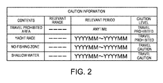
- the caution information memory 24 is, for example, a hard disk drive, and is stored with caution information having influence on the travel and associated with position, and time and date (see Fig. 2 ).
- the caution information list stored in the caution information memory 24 includes items of contents, a relevant range, a relevant period, and a caution level.
- the "CONTENTS” indicate a kind of caution information.
- the "TRAVEL PROHIBITED AREA” is an area where traveling is prohibited by law, etc.
- the "RELEVANT RANGE” indicates a range where the "CONTENTS” in the same row is applied. The relevant range is described by latitude and longitude specified in its range.
- the "RELEVANT PERIOD” indicates a period for which the "CONTENTS” in the same row is applied. The describing method of the relevant period is arbitrary, for example, it may be described by time, or as "ANYTIME.”
- the "LEVEL” indicates a level of influence on the travel.
- TRAVEL PROHIBITED indicates a state where passing the relevant location (area, section, etc.) itself is prohibited.
- TRAVEL CAUTION indicates a state where the passing itself is not prohibited, but for example, fishing in the relevant location (area, section, etc.) is prohibited or caution for grounding is issued therein.
- the nautical chart information memory 25 is, for example, a hard disk drive, and is stored with an electronic nautical chart.
- the hard disk drive it may be constituted with a memory media (e.g., DVD or memory card) and a device for reading information from the memory media.
- the navigation apparatus 1 is configured as above. With this configuration, the control unit 22 of the instruction device 14 can automatically display the nautical chart for around the ship on the display, based on the ship positional information inputted from the GPS receiver 12 and the stored contents in the nautical chart information memory 25.
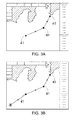
- Figs. 3A and 3B are views showing display screens when the route is created.
- Figs. 4A to 6B are views showing display screens when the route is verified. Note that, in each display screen, the area indicated by the diagonal lines is land, and other area indicates the sea.
- control unit 22 includes a route creator 31, a caution information reading portion 32, and a route verifying portion 33.
- the route creator 31 creates the route based on inputs (inputs of positions) by the user.
- the caution information reading portion 32 accesses the caution information memory 24 and, based on each inputted position of the route scheduled by the user, reads the caution information corresponding to the position concerned.
- the route verifying portion 33 verifies the route based on the caution information which is read by the caution information reading portion 32.
- the user controls the user interface 23 to activate a route creating mode, and the user specifies points (positions) on the nautical chart by clicking or touching. Thus, as shown in Fig. 3A , the specified points are connected with each other by a line. Additionally, the user specifies a destination of the route, and then determines the route to complete the route creation.
- the points specified by the user are referred to as waypoints 41.
- the waypoint 41 specified lastly has a mark surrounding it in circle.
- the mark indicates the destination of the route. Note that, a displaying form of the mark during the route creation is arbitrary, and the departure location can also have a mark. Additionally, for the kind of route, other than the route in which the departure location and the destination are specified, an endless route can also be created.
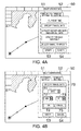
- the route verifying box 50 is displayed with a time and date setting tab 51, a display setting tab 52, a verifying key 53, and a cancellation key 54.
- the time and date setting tab 51 specifies time and date to travel the route.
- the display setting tab 52 changes the display setting when verifying the route.
- the verifying key 53 starts the route verification.
- the cancellation key 54 ends the mode for verifying the route.
- the "CURRENT TIME” is a specifying method in which current year, month, day and time (time and date) is set to be the travel time and date.
- the "SPECIFY TRAVEL DATE” is a specifying method in which a (one) predetermined time and date is specified and the specified time and date is set to be the travel time and date.
- the "SPECIFY DEPARTURE DATE AND ARRIVAL DATE” is a specifying method in which the time and date of departure (travel starting date) and the time and date of arrival (travel ending date) of the travel are specified.
- the "SPECIFY FOR EACH WAYPOINT” is a specifying method in which the time and date is specified for each waypoint 41.
- the "SELECT RANGE TO SPECIFY” is a specifying method in which the route is arbitrarily divided and the time and date is specified for each divided range.
- SPECIFY TRAVEL DATE is described in detail.
- a travel date specifying box 70 is displayed within the route verifying box 50.
- the travel date specifying box 70 is displayed with a year specifying section 71, a month specifying section 72, a day specifying section 73, a time and date determining key 74, and a cancellation key 75.
- the year specifying section 71, the month specifying section 72, and the day specifying section 73 are pull-down boxes, and year, month, and day can be specified therewithin. After year, month, and day are specified, by selecting (touching or clicking) the time and date determining key 74, the travel time and date can be specified. Alternatively, by selecting (touching, clicking) the cancellation key 75, the mode can return to selecting the specifying method for the travel time and date on the route.
- the verifying key 53 After the user specifies the travel time and date as described above, he/she selects (touches, clicks) the verifying key 53 (see Fig. 5A ). In this manner, the verification of the route scheduled by the user is performed.
- the verification is performed in the control unit 22 as follows. Specifically, firstly, the caution information reading portion 32 accesses the caution information memory 24 and reads the caution information corresponding to the travel time and date on the route specified by the user. Next, the route verifying portion 33 verifies whether useful caution information exists for the position on the route create by the user and the specified travel time and date. Note that, in this verification, it may be configured so that only the caution information for the positions on the route (overlapping with the route) is extracted, that the caution information for near the route is additionally extracted, or that only the caution information near the route is extracted.
- the route verifying portion 33 displays the relevant caution information on the display 21 (see Fig. 5B ).
- the caution information is displayed on the nautical chart within a range which the caution information indicates (a prohibited area 81 and a caution area 82 in Fig. 5B ). Additionally, in this embodiment, the mark displayed together with the range is varied according to the contents in "LEVEL" in the caution information list.
- a displaying form of the verification result from the route verifying portion 33 is arbitrary and can suitably be changed. For example, when the caution information in which the level is "TRAVEL PROHIBITED" is overlapped with the route (when the route cannot be traveled), this situation may be informed by displaying it in a large size. Additionally or alternatively, only the line of the part of the route overlapping with the caution information may be displayed thicker (or in a different color).
- a caution information display box 83 displaying detailed information of the caution information is displayed (see Fig. 6B ).
- the navigation apparatus 1 includes the display 21, the user interface 23, the caution information reading portion 32, and the route verifying portion 33.
- the display 21 displays on the chart, the user-scheduled route.
- the user interface 23 accepts the input of the travel time and date on the route.
- the caution information reading portion 32 reads the caution information based on the travel time and date inputted through the user interface 23.
- the route verifying portion 33 at least extracts the caution information on or near the one or more positions on the route, based on one or more positions indicated at which the caution information read by the caution information reading portion 32 indicates, and one or more positions on the route. Then the route verifying portion 33 verifies the route based on the extracted caution information.
- the method (100) includes creating a route according to an instruction from a user (S101), setting time and date to travel on the route according to an instruction from the user (S102), and reading caution information having influence on the travel and associated with position, and time and date (S103).
- the method also includes verifying whether the travel on the route is available based on one or more positions, and times and dates at which the read caution information indicates, one or more positions on the route, and the set travel time and date (S104).
- the reading caution information may include reading the caution information having influence on the travel, based on the set travel time and date, the caution information being associated with position, and time and date.
- the verifying whether the travel on the route is available may include verifying whether the travel on the route is available on the travel time and date based on at least the caution information on or near the one or more positions on the route among the read caution information read.
- the user can grasp the details of the caution information existing on the route on the inputted time and date. Therefore, a new route to travel can easily be planed, for example. Additionally, even when it is confirmed that the scheduled route cannot be traveled, unlike the conventional configuration, the travel time and date can easily be changed with the configuration described above, and therefore, it can easily be grasped whether the route after the change of the travel time and date can be traveled even before actually changing the travel time and date.
- the caution information memory 24 is not limited to the hard disk drive, and may be, as shown in Fig. 7A , a reader 24a that can read a memory card 24b which serves as a memory media. Additionally, the memory media is not limited to the memory card, and may be a CD, a DVD, etc.
- the caution information reading portion 32 is not limited to the configuration of reading the caution information from the memory which is locally connected.
- the ship can use internet via, for example, satellite communication, it may be configured such that the caution information is read out from a server 24c via internet 100, as shown in Fig. 7B .
- the method of specifying the travel time and date is arbitrary and not limited to the above configuration.
- the caution information described above is merely an example, and may include frozen water, etc.
- AIO Application Information Overlay
- latest information which is not reflected on the electronic nautical chart, or alternatively, temporal, preliminary, and additional information is described in association with position and time.
- the navigation apparatus 1 verifies the created route, it determines whether the information in the AIO on/near the route exists, and when the information in the AIO exists on/near the route, the information is displayed on the display 21 similarly to the above embodiment.
- the caution information has two kinds in the "LEVEL"; however, it may be one kind, three kinds, or more. In the case with three or more kinds, the displaying form thereof may be changed according to the level, similar to the above embodiment.
- the route verifying portion 33 may be displayed on an external display screen, or may be informed to the user by sound, light, etc.
- the movable body in which the route planning apparatus is equipped is not limited to ships, and may be airplanes, automobiles, etc.
Landscapes
- Engineering & Computer Science (AREA)
- Radar, Positioning & Navigation (AREA)
- Remote Sensing (AREA)
- Automation & Control Theory (AREA)
- Physics & Mathematics (AREA)
- General Physics & Mathematics (AREA)
- Navigation (AREA)
- Traffic Control Systems (AREA)
Abstract
Description
- The present invention generally relates to a route planning apparatus that can create and display a route.
- Conventionally, navigation devices have been known, which are equipped in movable bodies (e.g., automobiles, ships, airplanes) and create a route by being inputted with a departure location and a destination from a user. For example, the navigation devices equipped in automobiles are stored with maps, and based on these maps, it creates various kinds of routes according to a required time for travel and highway tolls, etc.
JP2010-139515A - The navigation device in
JP2010-139515A - Moreover, the navigation device in
JP2010-139515A - However, in fact, there is a case where the road on the route is not passable because the road is under construction or too narrow for the size of the automobile (e.g., large-sized vehicle) equipped with the navigation device to pass, or the entry into the road is simply prohibited depending on the season. Particularly, in a case of performing navigation, many locations are not passable, such as, travel prohibited area, shallow water, frozen water, and yacht race venue, and also it is not rare that the unpassable locations change according to the time and season. In this regard,
JP2010-139515A - Moreover, depending on the movable body and the traveling purpose, it is desired to move along the route scheduled by the user, and not the route proposed by the navigation device (e.g., when it is desired to perform navigation to efficiently bypass a plurality of fish reefs). In other words, it has been desired to provide a device for verifying whether a route scheduled by a user can be traveled, and not for creating a route by itself.
- The present invention is made in view of the above situation, and it provides a route planning apparatus that can verify whether a route scheduled by a user can be traveled at a specified time and date.
- According to an aspect of the invention, a route planning apparatus is provided. The apparatus includes a display, a user interface, a caution information reading portion, and a route verifying portion. The display displays a user-scheduled route on a map. The user interface accepts an input of time and date to travel on the route. The caution information reading portion reads caution information having influence on the travel and associated with position, and time and date. The route verifying portion verifies whether the travel on the route is available based on one or more positions, and times and dates at which the caution information read by the caution information reading portion indicates, one or more positions on the route, and the inputted travel time and date.
- In this manner, the user can grasp the details of the caution information existing on (or near) the route on the inputted time and date among all the caution information existing on the map. Therefore, a new route to travel can easily be planed, for example. Additionally, even when it is confirmed that the scheduled route cannot be traveled, the route or the travel time and date can easily be changed with the configuration described above, and therefore, it can easily be learned whether the travel is available on the route or the travel time and date after being changed, even before actually changing the travel time and date.
- The caution information reading portion may read the caution information having influence on the travel, based on the travel time and date inputted through the user interface, the caution information being associated with position, and time and date. The verifier may verify whether the travel on the route is available on the travel time and date based on at least the caution information on or near the one or more positions on the route among the caution information read by the caution informationreading portion.
- In this manner, the user can grasp the details of the caution information on the route (or near the route) at the inputted time and date. Therefore, for example, a future route can easily be planned. Additionally, even when it is confirmed that the created route cannot be traveled, because the above configuration can easily change the travel time and date, it can easily be learned whether the route after the change of the travel time and date can be traveled even before actually changing the travel time and date.
- The caution information may contain information on at least one of a no-fishing zone and a travel prohibited area.
- In this manner, the user can learn that the set route cannot be traveled (or is unavailable for fishing).
- The user interface may accept inputs of a travel starting time and date and a travel ending time and date on the route.
- In this manner, even when travelling for a long period of time, the user can grasp caution information that corresponds to the schedule of the long time period travel to some level.
- The user interface may accept an input of a travel time and date for at least a partial range of the route formed by dividing the route.
- In this manner, even when travelling for a long period of time, the user can grasp caution information that corresponds to the schedule of the long time period travel to high level.
- The route verifying portion may verify that the travel along the route is not available when the caution information contains information on a travel prohibited area and the route includes a position at which the information on the travel prohibited area indicates.
- In this manner, the user can easily learn whether the created route can be traveled at the inputted travel time and date.
- The route planning apparatus may include a memory for either one of storing the caution information and reading a memory medium that is stored with the caution information. The caution information reading portion may read the caution information from the memory.
- In this manner, the caution information can be used even in an environment with no connection with internet. Therefore, the caution information can be safely used without circuit disturbance, etc.
- The caution information reading portion may read the caution information via internet.
- In this manner, latest caution information can easily be acquired.
- The display may display a verification result on the route that is outputted from the route verifying portion.
- In this manner, the user can easily grasp the verification result on the route.
- The display may display the route by changing a displaying form of the route according to the verification result.
- In this manner, the user can grasp the verification result on the route more easily. Particularly, when not only two kinds of navigable/unnavigable, but more kinds exist for the verification result, the verification result can be grasped by glancing.
- The route may be formed by connecting a plurality of waypoints with each other that are specified by the user.
- In this manner, the user can instinctively create the route. Additionally, when the route is determined as unnavigable and is recreated, the user is only required to move a predetermined waypoint (the user doesn't have to create the route from the start). Thus, a new route can easily be created.
- The user interface may accept the input of the travel time and date for each of the waypoints.
- In this manner, since the waypoint may be set to the position desired to pass, by inputting time and date that the user wants to pass the position, the travel time and date can be inputted in a method suitable for the using form by the user.
- The route planning apparatus may be equipped in a ship.
- In this manner, effects of the route planning apparatus in this aspect of the invention which is installed in the ship can be exerted.
- According to another aspect of the present invention, a method of planning and verifying a route is provided. The method includes creating a route according to an instruction from a user, setting time and date to travel on the route according to an instruction from the user, and reading caution information having influence on the travel and associated with position, and time and date. The method also includes verifying whether the travel on the route is available based on one or more positions, and times and dates at which the read caution information indicates, one or more positions on the route, and the set travel time and date.
- In this manner, the user can grasp the details of the caution information existing on (or near) the route on the inputted time and date among all the caution information existing on the map. Therefore, a new route to travel can easily be planed, for example. Additionally, even when it is confirmed that the scheduled route cannot be traveled, the route or the travel time and date can easily be changed with the configuration described above, and therefore, it can easily be learned whether the travel is available on the route or the travel time and date after being changed, even before actually changing the travel time and date.
- The reading caution information may include reading the caution information having influence on the travel, based on the set travel time and date, the caution information being associated with position, and time and date. The verifying whether the travel on the route is available may include verifying whether the travel on the route date is available on the travel time and based on at least the caution information on or near the one or more positions on the route among the read caution information.
- In this manner, the user can grasp the details of the caution information on the route (or near the route) at the inputted time and date. Therefore, for example, a future route can easily be planned. Additionally, even when it is confirmed that the created route cannot be traveled, because the above configuration can easily change the travel time and date, it can easily be learned whether the route after the change of the travel time and date can be traveled even before actually changing the travel time and date.
- The present disclosure is illustrated by way of example and not by way of limitation in the figures of the accompanying drawings, in which the like reference numeral indicate like elements and in which:
-
Fig. 1 is a block diagram showing an overall configuration of a navigation apparatus according to one embodiment of the invention; -
Fig. 2 is a table showing contents of a caution information list; -
Figs. 3A and 3B are views showing display screens when a route is created; -
Figs. 4A and 4B are views showing display screens when a time and date for performing a verification of the route is specified; -
Figs. 5A and 5B are views showing display screens when the verification of the route is performed; -
Figs. 6A and 6B are views showing display screens when details of the caution information indicating an overlap with the route is displayed; and -
Figs. 7A and 7B are block diagrams showing modifications of the navigation apparatus. -
Fig. 8 is a flowchart showing a method of planning and verifying a route according to the present invention. - Next, one embodiment of the present invention is described with reference to the appended drawings.
Fig. 1 is a block diagram showing an overall configuration of anavigation apparatus 1.Fig. 2 is a table showing contents of a caution information list. - The
navigation apparatus 1 is equipped in a ship, and can display a position of the ship on a nautical chart and create a route by an operation of a user. Thenavigation apparatus 1 can instruct an automatic steering device (not illustrated) to steer along the route. Thereby, the ship can travel along the route scheduled by the user. Hereinafter, the configuration of thenavigation apparatus 1 is described. - As shown in
Fig. 1 , thenavigation apparatus 1 includes aGPS receiver 12, anazimuth sensor 13, and aninstruction device 14. Theinstruction device 14 includes adisplay 21, acontrol unit 22, auser interface 23, a caution information memory 24 (memory), and a nauticalchart information memory 25. - The
GPS receiver 12 receives positioning signals from anGPS antenna 11 and detects current positional information of the position of the ship. The positional information calculated by theGPS receiver 12 is outputted to thecontrol unit 22 of theinstruction device 14. - The
azimuth sensor 13 has a plurality of GPS antennas fixed to the ship, and can detect a heading based on a relative positional relation of the GPS antennas. The heading calculated by theazimuth sensor 13 is transmitted to thecontrol unit 22 of theinstruction device 14. Note that, other than this configuration, for example, a magnetic azimuth sensor or a gyrocompass can be used as theazimuth sensor 13. - The
display 21 can display various kinds of images created by thenavigation apparatus 1. For example, thedisplay 21 can display images of the ship position and the route on the nautical chart. - The
control unit 22 is configured with hardware constituted with a CPU or other processor, volatile memory such as random access memory (RAM) and non-volatile memory such as Read Only Memory (ROM) (not illustrated), and software constituted with various programs stored in the ROM. Thecontrol unit 22 can perform a control (e.g., display control) of theinstruction device 14 by executing the programs. Note that, the programs may be stored in a memory media (e.g., CD-ROM or memory card) alternative to the configuration of being stored in the ROM provided to thecontrol unit 22. - The
user interface 23 is, for example, keys (keyboard) controlled by the user. The user can create the route or change a display setting by controlling theuser interface 23 to input an instruction. Note that, theuser interface 23 is not limited to physical keys, such as arrow keys or a rotational key, but may be a touch panel. Alternatively, it may be a mouse (pointing device) or a trackball for moving a pointer on a display screen, for example. - The
caution information memory 24 is, for example, a hard disk drive, and is stored with caution information having influence on the travel and associated with position, and time and date (seeFig. 2 ). The caution information list stored in thecaution information memory 24 includes items of contents, a relevant range, a relevant period, and a caution level. - The "CONTENTS" indicate a kind of caution information. For example, the "TRAVEL PROHIBITED AREA" is an area where traveling is prohibited by law, etc. The "RELEVANT RANGE" indicates a range where the "CONTENTS" in the same row is applied. The relevant range is described by latitude and longitude specified in its range. The "RELEVANT PERIOD" indicates a period for which the "CONTENTS" in the same row is applied. The describing method of the relevant period is arbitrary, for example, it may be described by time, or as "ANYTIME." The "LEVEL" indicates a level of influence on the travel. In this embodiment, two levels are set: "TRAVEL PROHIBITED" and "TRAVEL CAUTION." The "TRAVEL PROHIBITED" indicates a state where passing the relevant location (area, section, etc.) itself is prohibited. The "TRAVEL CAUTION" indicates a state where the passing itself is not prohibited, but for example, fishing in the relevant location (area, section, etc.) is prohibited or caution for grounding is issued therein.
- The nautical
chart information memory 25 is, for example, a hard disk drive, and is stored with an electronic nautical chart. Note that, alternative to the hard disk drive, it may be constituted with a memory media (e.g., DVD or memory card) and a device for reading information from the memory media. - The
navigation apparatus 1 is configured as above. With this configuration, thecontrol unit 22 of theinstruction device 14 can automatically display the nautical chart for around the ship on the display, based on the ship positional information inputted from theGPS receiver 12 and the stored contents in the nauticalchart information memory 25. - Hereinafter, a flow of creating a route by following an instruction from the user, and a flow of verifying the created route are described.
Figs. 3A and 3B are views showing display screens when the route is created.Figs. 4A to 6B are views showing display screens when the route is verified. Note that, in each display screen, the area indicated by the diagonal lines is land, and other area indicates the sea. - Moreover, the
control unit 22 includes aroute creator 31, a cautioninformation reading portion 32, and aroute verifying portion 33. Theroute creator 31 creates the route based on inputs (inputs of positions) by the user. The cautioninformation reading portion 32 accesses thecaution information memory 24 and, based on each inputted position of the route scheduled by the user, reads the caution information corresponding to the position concerned. Theroute verifying portion 33 verifies the route based on the caution information which is read by the cautioninformation reading portion 32. - When creating the route, the user controls the
user interface 23 to activate a route creating mode, and the user specifies points (positions) on the nautical chart by clicking or touching. Thus, as shown inFig. 3A , the specified points are connected with each other by a line. Additionally, the user specifies a destination of the route, and then determines the route to complete the route creation. - Here, the points specified by the user are referred to as
waypoints 41. Thewaypoint 41 specified lastly has a mark surrounding it in circle. The mark indicates the destination of the route. Note that, a displaying form of the mark during the route creation is arbitrary, and the departure location can also have a mark. Additionally, for the kind of route, other than the route in which the departure location and the destination are specified, an endless route can also be created. - After the user completes the route creation, he/she controls the
user interface 23 to display aroute verifying box 50 shown inFig. 4A , etc. As shown inFig. 4A , theroute verifying box 50 is displayed with a time anddate setting tab 51, adisplay setting tab 52, a verifyingkey 53, and acancellation key 54. - The time and
date setting tab 51 specifies time and date to travel the route. Thedisplay setting tab 52 changes the display setting when verifying the route. The verifying key 53 starts the route verification. The cancellation key 54 ends the mode for verifying the route. - In this embodiment, there are five kinds of methods of specifying the time and date to travel on the route. Therefore, five keys are displayed within the time and
date setting tab 51. Hereinafter, each key is described in order. - The "CURRENT TIME" is a specifying method in which current year, month, day and time (time and date) is set to be the travel time and date. The "SPECIFY TRAVEL DATE" is a specifying method in which a (one) predetermined time and date is specified and the specified time and date is set to be the travel time and date. The "SPECIFY DEPARTURE DATE AND ARRIVAL DATE" is a specifying method in which the time and date of departure (travel starting date) and the time and date of arrival (travel ending date) of the travel are specified. The "SPECIFY FOR EACH WAYPOINT" is a specifying method in which the time and date is specified for each
waypoint 41. The "SELECT RANGE TO SPECIFY" is a specifying method in which the route is arbitrarily divided and the time and date is specified for each divided range. - In this embodiment, the "SPECIFY TRAVEL DATE" is described in detail. When the user selects (touches or clicks) the "SPECIFY TRAVEL DATE" item, a travel
date specifying box 70 is displayed within theroute verifying box 50. The traveldate specifying box 70 is displayed with ayear specifying section 71, amonth specifying section 72, aday specifying section 73, a time anddate determining key 74, and acancellation key 75. - The
year specifying section 71, themonth specifying section 72, and theday specifying section 73 are pull-down boxes, and year, month, and day can be specified therewithin. After year, month, and day are specified, by selecting (touching or clicking) the time anddate determining key 74, the travel time and date can be specified. Alternatively, by selecting (touching, clicking) the cancellation key 75, the mode can return to selecting the specifying method for the travel time and date on the route. - Note that, in the specifying methods other than "SPECIFY TRAVEL DATE", processing of specifying a waypoint or a predetermined range, and specifying year, month, and day similarly to the above described method is performed. By repeating the processing, the travel time and date can be set, for example, for each waypoint or selected range. Moreover, when the specification is performed in any of these methods, the time and date between two specified points are automatically compensated. For example, when dates of adjacent waypoints are set to March 2, and March 4, within the predetermined range between the adjacent waypoints, the date is automatically set to March 3.
- After the user specifies the travel time and date as described above, he/she selects (touches, clicks) the verifying key 53 (see
Fig. 5A ). In this manner, the verification of the route scheduled by the user is performed. - The verification is performed in the
control unit 22 as follows. Specifically, firstly, the cautioninformation reading portion 32 accesses thecaution information memory 24 and reads the caution information corresponding to the travel time and date on the route specified by the user. Next, theroute verifying portion 33 verifies whether useful caution information exists for the position on the route create by the user and the specified travel time and date. Note that, in this verification, it may be configured so that only the caution information for the positions on the route (overlapping with the route) is extracted, that the caution information for near the route is additionally extracted, or that only the caution information near the route is extracted. - As a result of this verification, when relevant caution information exists, the
route verifying portion 33 displays the relevant caution information on the display 21 (seeFig. 5B ). The caution information is displayed on the nautical chart within a range which the caution information indicates (a prohibitedarea 81 and acaution area 82 inFig. 5B ). Additionally, in this embodiment, the mark displayed together with the range is varied according to the contents in "LEVEL" in the caution information list. - Note that, a displaying form of the verification result from the
route verifying portion 33 is arbitrary and can suitably be changed. For example, when the caution information in which the level is "TRAVEL PROHIBITED" is overlapped with the route (when the route cannot be traveled), this situation may be informed by displaying it in a large size. Additionally or alternatively, only the line of the part of the route overlapping with the caution information may be displayed thicker (or in a different color). - In addition, in this embodiment, by selecting a range which the caution information indicates (e.g., the prohibited
area 81 or the caution area 82) and further selecting (touching or clicking) the item "DETAIL" (seeFig. 6A ), a cautioninformation display box 83 displaying detailed information of the caution information is displayed (seeFig. 6B ). With this configuration, the period which is relevant to the caution information can easily be learnt, and therefore, the travel time and date can easily be set while avoiding the relevant period. Moreover, even when the level is "TRAVEL CAUTION," it can easily be confirmed that it is irrelevant to the travel of the ship. For example, when the purpose of the travel is to move, even if the route and a no-fishing area are overlapped with each other, no problem occurs. - As described above, the
navigation apparatus 1 includes thedisplay 21, theuser interface 23, the cautioninformation reading portion 32, and theroute verifying portion 33. Thedisplay 21 displays on the chart, the user-scheduled route. Theuser interface 23 accepts the input of the travel time and date on the route. The cautioninformation reading portion 32 reads the caution information based on the travel time and date inputted through theuser interface 23. Theroute verifying portion 33 at least extracts the caution information on or near the one or more positions on the route, based on one or more positions indicated at which the caution information read by the cautioninformation reading portion 32 indicates, and one or more positions on the route. Then theroute verifying portion 33 verifies the route based on the extracted caution information. - Therefore, a method of planning and verifying a route by using the
navigation apparatus 1 is as follows. With reference also to the flowchart shown inFig. 8 , the method (100) includes creating a route according to an instruction from a user (S101), setting time and date to travel on the route according to an instruction from the user (S102), and reading caution information having influence on the travel and associated with position, and time and date (S103). The method also includes verifying whether the travel on the route is available based on one or more positions, and times and dates at which the read caution information indicates, one or more positions on the route, and the set travel time and date (S104). - In the method, the reading caution information may include reading the caution information having influence on the travel, based on the set travel time and date, the caution information being associated with position, and time and date. In the method, the verifying whether the travel on the route is available may include verifying whether the travel on the route is available on the travel time and date based on at least the caution information on or near the one or more positions on the route among the read caution information read.
- In this manner, the user can grasp the details of the caution information existing on the route on the inputted time and date. Therefore, a new route to travel can easily be planed, for example. Additionally, even when it is confirmed that the scheduled route cannot be traveled, unlike the conventional configuration, the travel time and date can easily be changed with the configuration described above, and therefore, it can easily be grasped whether the route after the change of the travel time and date can be traveled even before actually changing the travel time and date.
- As above, the suitable embodiment and the modifications of the present invention are described. The above configuration may be modified as follows.
- The caution information memory 24 (memory) is not limited to the hard disk drive, and may be, as shown in
Fig. 7A , areader 24a that can read amemory card 24b which serves as a memory media. Additionally, the memory media is not limited to the memory card, and may be a CD, a DVD, etc. - The caution
information reading portion 32 is not limited to the configuration of reading the caution information from the memory which is locally connected. For example, when the ship can use internet via, for example, satellite communication, it may be configured such that the caution information is read out from aserver 24c viainternet 100, as shown inFig. 7B . - The method of specifying the travel time and date is arbitrary and not limited to the above configuration. Additionally, the caution information described above is merely an example, and may include frozen water, etc. Moreover, AIO (Admiralty Information Overlay) can be used as the caution information. In the AIO, latest information which is not reflected on the electronic nautical chart, or alternatively, temporal, preliminary, and additional information is described in association with position and time. Specifically, when the
navigation apparatus 1 verifies the created route, it determines whether the information in the AIO on/near the route exists, and when the information in the AIO exists on/near the route, the information is displayed on thedisplay 21 similarly to the above embodiment. - In the above embodiment, the caution information has two kinds in the "LEVEL"; however, it may be one kind, three kinds, or more. In the case with three or more kinds, the displaying form thereof may be changed according to the level, similar to the above embodiment.
- The
route verifying portion 33 may be displayed on an external display screen, or may be informed to the user by sound, light, etc. - The movable body in which the route planning apparatus is equipped is not limited to ships, and may be airplanes, automobiles, etc.
Claims (15)
- A route planning apparatus (1), comprising:a display (21) for displaying a user-scheduled route on a map;a user interface (23) for accepting an input of time and date to travel on the route;a caution information reading portion (32) for reading caution information having influence on the travel and associated with position, and time and date; anda route verifying portion (33) for verifying whether the travel on the route is available based on one or more positions, times and dates which the caution information read by the caution information reading portion (32) indicates, one or more positions on the route, and the inputted travel time and date.
- The apparatus (1) of Claim 1, wherein the caution information reading portion (32) reads the caution information having influence on the travel, based on the travel time and date inputted through the user interface (23), the caution information being associated with position, and time and date, and
wherein the verifier (33) verifies whether the travel on the route is available on the travel time and date based on at least the caution information on or near the one or more positions on the route among the caution information read by the caution information reading portion (23). - The apparatus (1) of Claim 1 or 2, wherein the caution information contains information on at least one of a no-fishing zone and a travel prohibited area (81).
- The apparatus (1) of any one of Claims 1 to 3, wherein the user interface (23) accepts inputs of a time and date of both of a travel starting and a travel ending.
- The apparatus (1) of any one of Claims 1 to 3, wherein the user interface (23) accepts an input of a travel time and date for at least a partial range of the route formed by dividing the route.
- The apparatus (1) of any one of Claims 1 to 5, wherein the route verifying portion (33) verifies that the travel along the route is not available when the caution information contains information on a travel prohibited area (81) and the route includes a position which the information on the travel prohibited area (81) indicates.
- The apparatus (1) of any one of Claims 1 to 6, further comprising a memory (24) for either one of storing the caution information and reading a memory medium (24b) that is stored with the caution information, wherein the caution information reading portion (32) reads the caution information from the memory.
- The apparatus (1) of any one of Claims 1 to 6, wherein the caution information reading portion (32) reads the caution information via internet (100).
- The apparatus (1) of any one Claims 1 to 8, wherein the display (21) displays a verification result on the route that is outputted from the route verifying portion (33).
- The apparatus (1) of Claim 9, wherein the display (21) displays the route by changing a displaying form of the route according to the verification result.
- The apparatus (1) of any one of Claims 1 to 10, wherein the route is formed by connecting a plurality of waypoints (41) with each other that are specified by the user.
- The apparatus (1) of Claim 11, wherein the user interface (23) accepts the input of the travel time and date for each of the waypoints (41).
- The apparatus (1) of any one of Claims 1 to 12, being equipped in a ship.
- A method of planning and verifying a route, comprising:creating a route according to an instruction from a user;setting time and date to travel on the route according to an instruction from the user;reading caution information having influence on the travel and associated with position, and time and date; andverifying whether the travel on the route is available based on one or more positions, and times and dates at which the caution information read in the reading the caution information indicates, one or more positions on the route, and the set travel time and date.
- The method of Claim 14, wherein the reading caution information includes reading the caution information having influence on the travel, based on the set travel time and date, the caution information being associated with position, and time and date, and
wherein the verifying whether the travel on the route is available includes verifying whether the travel on the route is available on the travel time and date based on at least the caution information on or near the one or more positions on the route among the read caution information.
Applications Claiming Priority (1)
| Application Number | Priority Date | Filing Date | Title |
|---|---|---|---|
| JP2012090563A JP6076611B2 (en) | 2012-04-11 | 2012-04-11 | Route planning apparatus and route plan verification method |
Publications (2)
| Publication Number | Publication Date |
|---|---|
| EP2650645A1 true EP2650645A1 (en) | 2013-10-16 |
| EP2650645B1 EP2650645B1 (en) | 2022-03-30 |
Family
ID=48095663
Family Applications (1)
| Application Number | Title | Priority Date | Filing Date |
|---|---|---|---|
| EP13163359.6A Active EP2650645B1 (en) | 2012-04-11 | 2013-04-11 | Maritime route planning apparatus and maritime route plan verifying method |
Country Status (4)
| Country | Link |
|---|---|
| US (1) | US9612120B2 (en) |
| EP (1) | EP2650645B1 (en) |
| JP (1) | JP6076611B2 (en) |
| CN (1) | CN103376109B (en) |
Cited By (1)
| Publication number | Priority date | Publication date | Assignee | Title |
|---|---|---|---|---|
| US9958276B2 (en) * | 2013-11-12 | 2018-05-01 | E-Odyn Sas | Method for calculating the surface speed of at least one vessel and method for deducing each drift vector at every point on the path of said vessel |
Families Citing this family (14)
| Publication number | Priority date | Publication date | Assignee | Title |
|---|---|---|---|---|
| JP6288933B2 (en) * | 2013-04-12 | 2018-03-07 | 古野電気株式会社 | Route display device and route display method |
| JP6441014B2 (en) * | 2014-10-02 | 2018-12-19 | 拓 管谷 | Trailing wind direction display device and program for sailing yachts |
| EP3394846A4 (en) * | 2015-12-21 | 2019-01-02 | SZ DJI Technology Co., Ltd. | Targeted flight restricted regions |
| JP6529429B2 (en) * | 2015-12-22 | 2019-06-12 | 本田技研工業株式会社 | Traffic information output system and traffic information output method |
| WO2018168256A1 (en) * | 2017-03-13 | 2018-09-20 | 日本無線株式会社 | Voyage plan design assistance device, voyage plan design assistance system, display operation device divider, and display operation device unit |
| JP6762674B2 (en) * | 2017-03-13 | 2020-09-30 | 日本無線株式会社 | Voyage planning assistance device and voyage planning assistance system |
| JP7051390B2 (en) * | 2017-11-22 | 2022-04-11 | 古野電気株式会社 | Route setting device, autopilot and route setting method |
| JP7176144B2 (en) * | 2017-11-22 | 2022-11-21 | 古野電気株式会社 | Route setting device, autopilot device and route setting method |
| JP7084806B2 (en) * | 2018-07-10 | 2022-06-15 | 古野電気株式会社 | Navigation equipment and route creation method |
| CN111127138A (en) * | 2019-12-05 | 2020-05-08 | 汉能公务航空有限公司 | Air route measuring, calculating and quoting system |
| JP7518890B2 (en) | 2020-02-12 | 2024-07-18 | 古野電気株式会社 | Route planning device, route planning method, and program |
| CN115004280A (en) * | 2020-02-12 | 2022-09-02 | 古野电气株式会社 | Route planning device, route planning method, and program |
| CN114088100B (en) * | 2022-01-11 | 2022-05-06 | 中科星图智慧科技有限公司 | Path planning method and device based on complex conditions |
| US20260070635A1 (en) * | 2024-09-12 | 2026-03-12 | Johnson Outdoors Inc. | System and method for dynamic navigation routing for inshore and nearshore coastal areas |
Citations (3)
| Publication number | Priority date | Publication date | Assignee | Title |
|---|---|---|---|---|
| US7268703B1 (en) * | 2003-09-18 | 2007-09-11 | Garmin Ltd. | Methods, systems, and devices for cartographic alerts |
| JP2010139515A (en) | 2010-03-16 | 2010-06-24 | Aisin Aw Co Ltd | Navigation device |
| GB2474715A (en) * | 2009-10-26 | 2011-04-27 | Brian Leslie Russell Stannah | Aiding navigation of a marine vessel in a tidal region |
Family Cites Families (23)
| Publication number | Priority date | Publication date | Assignee | Title |
|---|---|---|---|---|
| JPS6318411A (en) * | 1986-07-10 | 1988-01-26 | Ishikawajima Harima Heavy Ind Co Ltd | Optimum sea route determining method |
| JPH07248727A (en) * | 1994-03-14 | 1995-09-26 | Sanyo Electric Co Ltd | Chart information processor and chart information processing method |
| US6199008B1 (en) * | 1998-09-17 | 2001-03-06 | Noegenesis, Inc. | Aviation, terrain and weather display system |
| US6381538B1 (en) * | 2000-05-26 | 2002-04-30 | Aerotech Research (U.S.A.), Inc. | Vehicle specific hazard estimation, presentation, and route planning based on meteorological and other environmental data |
| JP2002090171A (en) * | 2000-09-13 | 2002-03-27 | Todaka Seisakusho:Kk | Automatic route keeping device for ships |
| US6865476B1 (en) * | 2003-02-12 | 2005-03-08 | John B. Jokerst, Sr. | Nautical waypoints and routes data sets |
| KR100513009B1 (en) * | 2003-04-04 | 2005-09-05 | 삼성전자주식회사 | Navigation system for providing warning restrictedly, apparatus and method for providing warning restrictedly in navigation system |
| JP3950975B2 (en) * | 2003-12-04 | 2007-08-01 | 独立行政法人海上技術安全研究所 | Navigation planning support system |
| JP4547616B2 (en) * | 2004-09-08 | 2010-09-22 | アイシン・エィ・ダブリュ株式会社 | Navigation device |
| US7774133B2 (en) * | 2006-07-05 | 2010-08-10 | Sap Ag | Method and apparatus for trip routing with configurable constraints |
| US20080033644A1 (en) * | 2006-08-03 | 2008-02-07 | Bannon Sean A | Navigation Routing System Having Environmentally Triggered Routing |
| GB2441802A (en) * | 2006-09-13 | 2008-03-19 | Marine & Remote Sensing Soluti | Safety system for a vehicle |
| US8296001B1 (en) * | 2006-11-13 | 2012-10-23 | Garmin Switzerland Gmbh | Marine vessel navigation device, system and method |
| US7818120B2 (en) * | 2006-11-30 | 2010-10-19 | Raytheon Company | Route-planning interactive navigation system and method |
| WO2008091574A1 (en) * | 2007-01-22 | 2008-07-31 | Truenorth Global Inc. | Integrated weather display and travel and navigation decision system |
| US7860646B2 (en) * | 2007-04-16 | 2010-12-28 | The Boeing Company | Method and apparatus for routing ocean going vessels to avoid treacherous environments |
| ATE531019T1 (en) * | 2008-01-21 | 2011-11-15 | Thales Nederland Bv | SECURITY AND SECURITY SYSTEM AGAINST MULTIPLE THREATS AND DETERMINATION PROCEDURES THEREFOR |
| JP5173632B2 (en) | 2008-07-03 | 2013-04-03 | 株式会社日立製作所 | Method for discriminating vehicle types of rail vehicles |
| JP2010121947A (en) * | 2008-11-17 | 2010-06-03 | Alpine Electronics Inc | Method and system for navigation for shipping |
| US8155811B2 (en) * | 2008-12-29 | 2012-04-10 | General Electric Company | System and method for optimizing a path for a marine vessel through a waterway |
| US9109895B2 (en) * | 2009-04-30 | 2015-08-18 | The Boeing Company | Estimating probabilities of arrival times for voyages |
| US8594866B1 (en) * | 2010-04-16 | 2013-11-26 | The Boeing Company | Remote sensing and determination of tactical ship readiness |
| US8634975B2 (en) * | 2010-04-16 | 2014-01-21 | The Boeing Company | Vessel performance optimization reporting tool |
-
2012
- 2012-04-11 JP JP2012090563A patent/JP6076611B2/en active Active
-
2013
- 2013-04-07 CN CN201310116750.0A patent/CN103376109B/en active Active
- 2013-04-11 EP EP13163359.6A patent/EP2650645B1/en active Active
- 2013-04-11 US US13/861,263 patent/US9612120B2/en active Active
Patent Citations (3)
| Publication number | Priority date | Publication date | Assignee | Title |
|---|---|---|---|---|
| US7268703B1 (en) * | 2003-09-18 | 2007-09-11 | Garmin Ltd. | Methods, systems, and devices for cartographic alerts |
| GB2474715A (en) * | 2009-10-26 | 2011-04-27 | Brian Leslie Russell Stannah | Aiding navigation of a marine vessel in a tidal region |
| JP2010139515A (en) | 2010-03-16 | 2010-06-24 | Aisin Aw Co Ltd | Navigation device |
Cited By (1)
| Publication number | Priority date | Publication date | Assignee | Title |
|---|---|---|---|---|
| US9958276B2 (en) * | 2013-11-12 | 2018-05-01 | E-Odyn Sas | Method for calculating the surface speed of at least one vessel and method for deducing each drift vector at every point on the path of said vessel |
Also Published As
| Publication number | Publication date |
|---|---|
| JP6076611B2 (en) | 2017-02-08 |
| CN103376109A (en) | 2013-10-30 |
| US9612120B2 (en) | 2017-04-04 |
| JP2013217860A (en) | 2013-10-24 |
| US20130275046A1 (en) | 2013-10-17 |
| CN103376109B (en) | 2017-06-27 |
| EP2650645B1 (en) | 2022-03-30 |
Similar Documents
| Publication | Publication Date | Title |
|---|---|---|
| EP2650645B1 (en) | Maritime route planning apparatus and maritime route plan verifying method | |
| CN107346137B (en) | Network-based storage for vehicles and infrastructure data for optimizing vehicle route planning | |
| JP5225099B2 (en) | Method and system for displaying procedural information | |
| US8670922B2 (en) | Guiding route generation device and guiding route generation method | |
| CN108603763B (en) | Travel plan generating device, travel plan generating method, and computer-readable recording medium | |
| US9214132B2 (en) | Electronic chart display device and method of displaying information relating to electronic chart | |
| US20080133131A1 (en) | Route-planning interactive navigation system and method | |
| US20130124082A1 (en) | Navigation system and displaying method thereof | |
| EP2031350A1 (en) | Methods, systems, and apparatus for routing a vehicle to avoid an adverse condition | |
| US20190383635A1 (en) | Method and device for constructing traffic route on basis of longitude/latitude lines and performing map search | |
| US20180180439A1 (en) | Navigation system | |
| JP4645203B2 (en) | Guide route generation device and guide route generation method | |
| KR20140030685A (en) | Navigation device capable of searching path passing the plural poi and method thereof | |
| KR20140000488A (en) | Method for guiding turn point of crossroad and navigation system | |
| WO2015144921A1 (en) | Method and apparatus for generating a map of the terrain in a geographic area | |
| JP2005221781A (en) | Magnified intersection image display apparatus, navigation system, and magnified intersection image display method | |
| JP2005326333A (en) | Intersection guiding method and navigation system | |
| GB2524514A (en) | Navigation system | |
| EP2650647B1 (en) | Nautical license identification system | |
| US9574900B2 (en) | Navigation apparatus and method for drawing map | |
| JP4231063B2 (en) | Navigation system | |
| JP4661336B2 (en) | Navigation device, display method, and information retrieval method | |
| JP2002267473A (en) | Navigation system | |
| RU2420782C2 (en) | Navigation device and method of warning on speed traps | |
| JP2022023880A (en) | Display control device, display control method, display control program, and computer-readable storage medium on which display control program is recorded |
Legal Events
| Date | Code | Title | Description |
|---|---|---|---|
| PUAI | Public reference made under article 153(3) epc to a published international application that has entered the european phase |
Free format text: ORIGINAL CODE: 0009012 |
|
| AK | Designated contracting states |
Kind code of ref document: A1 Designated state(s): AL AT BE BG CH CY CZ DE DK EE ES FI FR GB GR HR HU IE IS IT LI LT LU LV MC MK MT NL NO PL PT RO RS SE SI SK SM TR |
|
| AX | Request for extension of the european patent |
Extension state: BA ME |
|
| 17P | Request for examination filed |
Effective date: 20140326 |
|
| RBV | Designated contracting states (corrected) |
Designated state(s): AL AT BE BG CH CY CZ DE DK EE ES FI FR GB GR HR HU IE IS IT LI LT LU LV MC MK MT NL NO PL PT RO RS SE SI SK SM TR |
|
| STAA | Information on the status of an ep patent application or granted ep patent |
Free format text: STATUS: EXAMINATION IS IN PROGRESS |
|
| 17Q | First examination report despatched |
Effective date: 20170316 |
|
| GRAP | Despatch of communication of intention to grant a patent |
Free format text: ORIGINAL CODE: EPIDOSNIGR1 |
|
| STAA | Information on the status of an ep patent application or granted ep patent |
Free format text: STATUS: GRANT OF PATENT IS INTENDED |
|
| INTG | Intention to grant announced |
Effective date: 20211110 |
|
| GRAS | Grant fee paid |
Free format text: ORIGINAL CODE: EPIDOSNIGR3 |
|
| GRAA | (expected) grant |
Free format text: ORIGINAL CODE: 0009210 |
|
| STAA | Information on the status of an ep patent application or granted ep patent |
Free format text: STATUS: THE PATENT HAS BEEN GRANTED |
|
| AK | Designated contracting states |
Kind code of ref document: B1 Designated state(s): AL AT BE BG CH CY CZ DE DK EE ES FI FR GB GR HR HU IE IS IT LI LT LU LV MC MK MT NL NO PL PT RO RS SE SI SK SM TR |
|
| REG | Reference to a national code |
Ref country code: GB Ref legal event code: FG4D |
|
| REG | Reference to a national code |
Ref country code: CH Ref legal event code: EP |
|
| REG | Reference to a national code |
Ref country code: DE Ref legal event code: R096 Ref document number: 602013081237 Country of ref document: DE |
|
| REG | Reference to a national code |
Ref country code: AT Ref legal event code: REF Ref document number: 1479578 Country of ref document: AT Kind code of ref document: T Effective date: 20220415 |
|
| REG | Reference to a national code |
Ref country code: IE Ref legal event code: FG4D |
|
| REG | Reference to a national code |
Ref country code: LT Ref legal event code: MG9D |
|
| PG25 | Lapsed in a contracting state [announced via postgrant information from national office to epo] |
Ref country code: SE Free format text: LAPSE BECAUSE OF FAILURE TO SUBMIT A TRANSLATION OF THE DESCRIPTION OR TO PAY THE FEE WITHIN THE PRESCRIBED TIME-LIMIT Effective date: 20220330 Ref country code: RS Free format text: LAPSE BECAUSE OF FAILURE TO SUBMIT A TRANSLATION OF THE DESCRIPTION OR TO PAY THE FEE WITHIN THE PRESCRIBED TIME-LIMIT Effective date: 20220330 Ref country code: NO Free format text: LAPSE BECAUSE OF FAILURE TO SUBMIT A TRANSLATION OF THE DESCRIPTION OR TO PAY THE FEE WITHIN THE PRESCRIBED TIME-LIMIT Effective date: 20220630 Ref country code: LT Free format text: LAPSE BECAUSE OF FAILURE TO SUBMIT A TRANSLATION OF THE DESCRIPTION OR TO PAY THE FEE WITHIN THE PRESCRIBED TIME-LIMIT Effective date: 20220330 Ref country code: HR Free format text: LAPSE BECAUSE OF FAILURE TO SUBMIT A TRANSLATION OF THE DESCRIPTION OR TO PAY THE FEE WITHIN THE PRESCRIBED TIME-LIMIT Effective date: 20220330 Ref country code: BG Free format text: LAPSE BECAUSE OF FAILURE TO SUBMIT A TRANSLATION OF THE DESCRIPTION OR TO PAY THE FEE WITHIN THE PRESCRIBED TIME-LIMIT Effective date: 20220630 |
|
| REG | Reference to a national code |
Ref country code: NL Ref legal event code: MP Effective date: 20220330 |
|
| REG | Reference to a national code |
Ref country code: AT Ref legal event code: MK05 Ref document number: 1479578 Country of ref document: AT Kind code of ref document: T Effective date: 20220330 |
|
| PG25 | Lapsed in a contracting state [announced via postgrant information from national office to epo] |
Ref country code: LV Free format text: LAPSE BECAUSE OF FAILURE TO SUBMIT A TRANSLATION OF THE DESCRIPTION OR TO PAY THE FEE WITHIN THE PRESCRIBED TIME-LIMIT Effective date: 20220330 Ref country code: GR Free format text: LAPSE BECAUSE OF FAILURE TO SUBMIT A TRANSLATION OF THE DESCRIPTION OR TO PAY THE FEE WITHIN THE PRESCRIBED TIME-LIMIT Effective date: 20220701 Ref country code: FI Free format text: LAPSE BECAUSE OF FAILURE TO SUBMIT A TRANSLATION OF THE DESCRIPTION OR TO PAY THE FEE WITHIN THE PRESCRIBED TIME-LIMIT Effective date: 20220330 |
|
| PG25 | Lapsed in a contracting state [announced via postgrant information from national office to epo] |
Ref country code: NL Free format text: LAPSE BECAUSE OF FAILURE TO SUBMIT A TRANSLATION OF THE DESCRIPTION OR TO PAY THE FEE WITHIN THE PRESCRIBED TIME-LIMIT Effective date: 20220330 |
|
| PG25 | Lapsed in a contracting state [announced via postgrant information from national office to epo] |
Ref country code: SM Free format text: LAPSE BECAUSE OF FAILURE TO SUBMIT A TRANSLATION OF THE DESCRIPTION OR TO PAY THE FEE WITHIN THE PRESCRIBED TIME-LIMIT Effective date: 20220330 Ref country code: RO Free format text: LAPSE BECAUSE OF FAILURE TO SUBMIT A TRANSLATION OF THE DESCRIPTION OR TO PAY THE FEE WITHIN THE PRESCRIBED TIME-LIMIT Effective date: 20220330 Ref country code: PT Free format text: LAPSE BECAUSE OF FAILURE TO SUBMIT A TRANSLATION OF THE DESCRIPTION OR TO PAY THE FEE WITHIN THE PRESCRIBED TIME-LIMIT Effective date: 20220801 Ref country code: ES Free format text: LAPSE BECAUSE OF FAILURE TO SUBMIT A TRANSLATION OF THE DESCRIPTION OR TO PAY THE FEE WITHIN THE PRESCRIBED TIME-LIMIT Effective date: 20220330 Ref country code: EE Free format text: LAPSE BECAUSE OF FAILURE TO SUBMIT A TRANSLATION OF THE DESCRIPTION OR TO PAY THE FEE WITHIN THE PRESCRIBED TIME-LIMIT Effective date: 20220330 Ref country code: CZ Free format text: LAPSE BECAUSE OF FAILURE TO SUBMIT A TRANSLATION OF THE DESCRIPTION OR TO PAY THE FEE WITHIN THE PRESCRIBED TIME-LIMIT Effective date: 20220330 Ref country code: AT Free format text: LAPSE BECAUSE OF FAILURE TO SUBMIT A TRANSLATION OF THE DESCRIPTION OR TO PAY THE FEE WITHIN THE PRESCRIBED TIME-LIMIT Effective date: 20220330 |
|
| PG25 | Lapsed in a contracting state [announced via postgrant information from national office to epo] |
Ref country code: PL Free format text: LAPSE BECAUSE OF FAILURE TO SUBMIT A TRANSLATION OF THE DESCRIPTION OR TO PAY THE FEE WITHIN THE PRESCRIBED TIME-LIMIT Effective date: 20220330 Ref country code: IS Free format text: LAPSE BECAUSE OF FAILURE TO SUBMIT A TRANSLATION OF THE DESCRIPTION OR TO PAY THE FEE WITHIN THE PRESCRIBED TIME-LIMIT Effective date: 20220730 Ref country code: AL Free format text: LAPSE BECAUSE OF FAILURE TO SUBMIT A TRANSLATION OF THE DESCRIPTION OR TO PAY THE FEE WITHIN THE PRESCRIBED TIME-LIMIT Effective date: 20220330 |
|
| REG | Reference to a national code |
Ref country code: CH Ref legal event code: PL |
|
| REG | Reference to a national code |
Ref country code: DE Ref legal event code: R097 Ref document number: 602013081237 Country of ref document: DE |
|
| REG | Reference to a national code |
Ref country code: BE Ref legal event code: MM Effective date: 20220430 |
|
| PG25 | Lapsed in a contracting state [announced via postgrant information from national office to epo] |
Ref country code: MC Free format text: LAPSE BECAUSE OF FAILURE TO SUBMIT A TRANSLATION OF THE DESCRIPTION OR TO PAY THE FEE WITHIN THE PRESCRIBED TIME-LIMIT Effective date: 20220330 Ref country code: LU Free format text: LAPSE BECAUSE OF NON-PAYMENT OF DUE FEES Effective date: 20220411 Ref country code: LI Free format text: LAPSE BECAUSE OF NON-PAYMENT OF DUE FEES Effective date: 20220430 Ref country code: DK Free format text: LAPSE BECAUSE OF FAILURE TO SUBMIT A TRANSLATION OF THE DESCRIPTION OR TO PAY THE FEE WITHIN THE PRESCRIBED TIME-LIMIT Effective date: 20220330 Ref country code: CH Free format text: LAPSE BECAUSE OF NON-PAYMENT OF DUE FEES Effective date: 20220430 |
|
| PLBE | No opposition filed within time limit |
Free format text: ORIGINAL CODE: 0009261 |
|
| STAA | Information on the status of an ep patent application or granted ep patent |
Free format text: STATUS: NO OPPOSITION FILED WITHIN TIME LIMIT |
|
| PG25 | Lapsed in a contracting state [announced via postgrant information from national office to epo] |
Ref country code: BE Free format text: LAPSE BECAUSE OF NON-PAYMENT OF DUE FEES Effective date: 20220430 |
|
| 26N | No opposition filed |
Effective date: 20230103 |
|
| PG25 | Lapsed in a contracting state [announced via postgrant information from national office to epo] |
Ref country code: IE Free format text: LAPSE BECAUSE OF NON-PAYMENT OF DUE FEES Effective date: 20220411 Ref country code: FR Free format text: LAPSE BECAUSE OF NON-PAYMENT OF DUE FEES Effective date: 20220530 |
|
| PG25 | Lapsed in a contracting state [announced via postgrant information from national office to epo] |
Ref country code: SI Free format text: LAPSE BECAUSE OF FAILURE TO SUBMIT A TRANSLATION OF THE DESCRIPTION OR TO PAY THE FEE WITHIN THE PRESCRIBED TIME-LIMIT Effective date: 20220330 |
|
| P01 | Opt-out of the competence of the unified patent court (upc) registered |
Effective date: 20230523 |
|
| PG25 | Lapsed in a contracting state [announced via postgrant information from national office to epo] |
Ref country code: IT Free format text: LAPSE BECAUSE OF FAILURE TO SUBMIT A TRANSLATION OF THE DESCRIPTION OR TO PAY THE FEE WITHIN THE PRESCRIBED TIME-LIMIT Effective date: 20220330 |
|
| PG25 | Lapsed in a contracting state [announced via postgrant information from national office to epo] |
Ref country code: HU Free format text: LAPSE BECAUSE OF FAILURE TO SUBMIT A TRANSLATION OF THE DESCRIPTION OR TO PAY THE FEE WITHIN THE PRESCRIBED TIME-LIMIT; INVALID AB INITIO Effective date: 20130411 |
|
| PG25 | Lapsed in a contracting state [announced via postgrant information from national office to epo] |
Ref country code: MK Free format text: LAPSE BECAUSE OF FAILURE TO SUBMIT A TRANSLATION OF THE DESCRIPTION OR TO PAY THE FEE WITHIN THE PRESCRIBED TIME-LIMIT Effective date: 20220330 Ref country code: CY Free format text: LAPSE BECAUSE OF FAILURE TO SUBMIT A TRANSLATION OF THE DESCRIPTION OR TO PAY THE FEE WITHIN THE PRESCRIBED TIME-LIMIT Effective date: 20220330 |
|
| PG25 | Lapsed in a contracting state [announced via postgrant information from national office to epo] |
Ref country code: SK Free format text: LAPSE BECAUSE OF FAILURE TO SUBMIT A TRANSLATION OF THE DESCRIPTION OR TO PAY THE FEE WITHIN THE PRESCRIBED TIME-LIMIT Effective date: 20220330 |
|
| PG25 | Lapsed in a contracting state [announced via postgrant information from national office to epo] |
Ref country code: SK Free format text: LAPSE BECAUSE OF FAILURE TO SUBMIT A TRANSLATION OF THE DESCRIPTION OR TO PAY THE FEE WITHIN THE PRESCRIBED TIME-LIMIT Effective date: 20220330 |
|
| PG25 | Lapsed in a contracting state [announced via postgrant information from national office to epo] |
Ref country code: MT Free format text: LAPSE BECAUSE OF FAILURE TO SUBMIT A TRANSLATION OF THE DESCRIPTION OR TO PAY THE FEE WITHIN THE PRESCRIBED TIME-LIMIT Effective date: 20220330 |
|
| PGFP | Annual fee paid to national office [announced via postgrant information from national office to epo] |
Ref country code: DE Payment date: 20250305 Year of fee payment: 13 |
|
| PG25 | Lapsed in a contracting state [announced via postgrant information from national office to epo] |
Ref country code: TR Free format text: LAPSE BECAUSE OF FAILURE TO SUBMIT A TRANSLATION OF THE DESCRIPTION OR TO PAY THE FEE WITHIN THE PRESCRIBED TIME-LIMIT Effective date: 20220330 |
|
| PGFP | Annual fee paid to national office [announced via postgrant information from national office to epo] |
Ref country code: GB Payment date: 20260313 Year of fee payment: 14 |