EP2581704A1 - Verfahren zur Kompression von Navigationskartendaten - Google Patents
Verfahren zur Kompression von Navigationskartendaten Download PDFInfo
- Publication number
- EP2581704A1 EP2581704A1 EP11185269.5A EP11185269A EP2581704A1 EP 2581704 A1 EP2581704 A1 EP 2581704A1 EP 11185269 A EP11185269 A EP 11185269A EP 2581704 A1 EP2581704 A1 EP 2581704A1
- Authority
- EP
- European Patent Office
- Prior art keywords
- block
- compressed
- navigation
- navigation map
- map data
- Prior art date
- Legal status (The legal status is an assumption and is not a legal conclusion. Google has not performed a legal analysis and makes no representation as to the accuracy of the status listed.)
- Withdrawn
Links
Images


Classifications
-
- G—PHYSICS
- G01—MEASURING; TESTING
- G01C—MEASURING DISTANCES, LEVELS OR BEARINGS; SURVEYING; NAVIGATION; GYROSCOPIC INSTRUMENTS; PHOTOGRAMMETRY OR VIDEOGRAMMETRY
- G01C21/00—Navigation; Navigational instruments not provided for in groups G01C1/00 - G01C19/00
- G01C21/38—Electronic maps specially adapted for navigation; Updating thereof
- G01C21/3863—Structures of map data
- G01C21/387—Organisation of map data, e.g. version management or database structures
-
- G—PHYSICS
- G09—EDUCATION; CRYPTOGRAPHY; DISPLAY; ADVERTISING; SEALS
- G09B—EDUCATIONAL OR DEMONSTRATION APPLIANCES; APPLIANCES FOR TEACHING, OR COMMUNICATING WITH, THE BLIND, DEAF OR MUTE; MODELS; PLANETARIA; GLOBES; MAPS; DIAGRAMS
- G09B29/00—Maps; Plans; Charts; Diagrams, e.g. route diagram
- G09B29/003—Maps
- G09B29/004—Map manufacture or repair; Tear or ink or water resistant maps; Long-life maps
-
- G—PHYSICS
- G01—MEASURING; TESTING
- G01C—MEASURING DISTANCES, LEVELS OR BEARINGS; SURVEYING; NAVIGATION; GYROSCOPIC INSTRUMENTS; PHOTOGRAMMETRY OR VIDEOGRAMMETRY
- G01C21/00—Navigation; Navigational instruments not provided for in groups G01C1/00 - G01C19/00
- G01C21/26—Navigation; Navigational instruments not provided for in groups G01C1/00 - G01C19/00 specially adapted for navigation in a road network
- G01C21/34—Route searching; Route guidance
- G01C21/3446—Details of route searching algorithms, e.g. Dijkstra, A*, arc-flags, using precalculated routes
-
- G—PHYSICS
- G01—MEASURING; TESTING
- G01C—MEASURING DISTANCES, LEVELS OR BEARINGS; SURVEYING; NAVIGATION; GYROSCOPIC INSTRUMENTS; PHOTOGRAMMETRY OR VIDEOGRAMMETRY
- G01C21/00—Navigation; Navigational instruments not provided for in groups G01C1/00 - G01C19/00
- G01C21/38—Electronic maps specially adapted for navigation; Updating thereof
- G01C21/3863—Structures of map data
- G01C21/387—Organisation of map data, e.g. version management or database structures
- G01C21/3881—Tile-based structures
-
- G—PHYSICS
- G06—COMPUTING; CALCULATING OR COUNTING
- G06F—ELECTRIC DIGITAL DATA PROCESSING
- G06F16/00—Information retrieval; Database structures therefor; File system structures therefor
- G06F16/20—Information retrieval; Database structures therefor; File system structures therefor of structured data, e.g. relational data
-
- G—PHYSICS
- G06—COMPUTING; CALCULATING OR COUNTING
- G06F—ELECTRIC DIGITAL DATA PROCESSING
- G06F16/00—Information retrieval; Database structures therefor; File system structures therefor
- G06F16/90—Details of database functions independent of the retrieved data types
- G06F16/95—Retrieval from the web
- G06F16/954—Navigation, e.g. using categorised browsing
-
- H—ELECTRICITY
- H03—ELECTRONIC CIRCUITRY
- H03M—CODING; DECODING; CODE CONVERSION IN GENERAL
- H03M7/00—Conversion of a code where information is represented by a given sequence or number of digits to a code where the same, similar or subset of information is represented by a different sequence or number of digits
- H03M7/30—Compression; Expansion; Suppression of unnecessary data, e.g. redundancy reduction
- H03M7/3084—Compression; Expansion; Suppression of unnecessary data, e.g. redundancy reduction using adaptive string matching, e.g. the Lempel-Ziv method
Definitions
- the invention relates to a method for generating compressed navigation map data from uncompressed navigation map data, to a compression module configured to generate the compressed navigation map data, to a method for providing navigation information to a user and to a navigation system providing navigation information to the user.
- Navigation systems are known which perform functions such as route searches between two locations. Modern navigation systems may also provide additional functionalities, such as serving as a travel guide that outputs, upon demand, information on points of interest, etc. Some navigation systems may even include travel guide functions to output detailed explanations, m textual and/or multimedia form.
- the different kinds of information provided to the user are all stored on a removable data storage unit, such as a CD ROM or DVD, or the information is provided on a hard disk.
- the navigation map data including the different kinds of information used to inform the user of needed information.
- a method for generating a compressed navigation map database from uncompressed navigation map data contains different building blocks of navigation data, each building block addressing a specific functional aspect of the navigation data and each building block containing byte sequences or strings of data.
- For the different building blocks of the uncompressed navigation map data most frequent substrings contained in the building blocks are determined. Furthermore, for the building blocks, the determined most frequent substrings of the building blocks are stored in at least one seed block. Furthermore, in the building blocks, the determined most frequent substrings stored in said at least one seed block are replaced in the strings by reference to said at least one seed block thereby generating compressed blocks. Furthermore, the compressed blocks and said at least one seed block are stored in order to generate the compressed navigation map database.
- each building block describing a predefined functional aspect of the navigation data e.g. a functional block is a route building block, a name building block.
- the navigation map data are further divided into different geographical regions and that the data may additionally be partitioned into different levels of detail.
- each functional building block describing a different aspect used in a navigation system to provide an output to the user e.g. a driving recommendation.
- the route building block provides the features for a routing calculation, the name building block containing the names of the streets shown on a map.
- each building block the data are stored in strings and depending on the content of a block the string may be a street name or may provide color information for an image.
- the most frequent substrings that are present in each block it is possible to combine the most frequent substrings in said at least one seed block and to include, in the building blocks, instead of the most frequent substring, a reference to said at least one seed block. In this way a compressed block is obtained needing less storage capacity than the uncompressed navigation map data. It is clear from the above said that the compression degree depends on the number of most frequent substrings stored in the seed block and which are not contained any more in the compressed blocks, but which are replaced by the reference to the seed block.
- the most frequent substrings of a plurality of building blocks are stored in one seed block. This means that in one seed block the most frequent substrings of two or more building blocks may be contained. In another embodiment, it is however possible that a seed block containing the most frequent substrings is determined for each building block. In this embodiment for each building block, a seed block and a compressed block exist, whereas in the embodiment for each building block a compressed block exists but not necessarily one seed block for each compressed block.
- each building block is separated in several parts before compression, wherein the most frequent substrings are determined for each part of a building block.
- the most frequent substrings of the different parts of a building block can then be stored in a single seed block.
- the replaced reference contains an offset information and a length information, the offset information indicating where in the seed block the replaced most frequent substring is located.
- the length information provides the information about the length of the replaced most frequent substring.
- the reference with the offset information and the length information may be necessary when the compressed navigation map data should be used again by a navigation system.
- the reference is replaced by the most frequent substring stored in the seed block again.
- the information is used where in the seed block the corresponding replaced most frequent substring is stored. Additionally, the information is used how long the replaced most frequent substring is.
- One possibility to determine the most frequent substrings of a block is to generate a prefix tree of the strings contained in a block and to determine the most frequent substrings in the prefix tree.
- a prefix tree the position of a string in the tree defines the strings it is associated with. All the decendents of a node have a common prefix of a string associated with that node. When frequency values are associated with each node, it is easily possible to determine the most frequent substrings of a block.
- the uncompressed navigation map data can contain different blocks, the route building block, the name building block, a traffic information building block, a 3D object building block, a junction view building block, or a digital terrain building block.
- the invention furthermore relates to a compression module configured to generate the compressed navigation map data, the module comprising the first database containing the uncompressed navigation map data, the uncompressed navigation map data containing the different building blocks of the navigation data, each building block addressing a specific functional aspect of the navigation map data and each block containing strings of data.
- a second database is provided in the compression module and a processing unit configured to determine the compressed blocks and said at least one seed block as mentioned above.
- the invention furthermore relates to a navigation system providing navigation information to the user, the navigation system comprising a storage unit containing compressed navigation map data, the compressed navigation map data containing different building blocks of navigation map data and each building block addresses a specific functional aspect of the navigation map data.
- the compressed navigation data contain at least one seed block and compressed blocks, said at least one seed block containing the most frequent substrings of the compressed blocks, wherein in the compressed blocks the determined most frequent substrings stored in said at least one seed block are replaced by a reference to said at least one seed block.
- the navigation system comprises an information unit providing navigation information to the user.
- the navigation information may be a visual output in 2D or 3D.
- the navigation system furthermore comprises a decompression unit configured to generate uncompressed navigation map data from the compressed navigation map data.
- the decompression unit accesses, for each building block, the compressed block and said at least one seed block and replaces the references contained in the compressed block by the corresponding most frequent substring of said at least one seed block in order to generate the uncompressed navigation map data.
- the decompression unit is furthermore configured to generate the navigation information based on the uncompressed navigation map data, the information unit using the uncompressed navigation map data to provide the navigation information to the user.
- the seed block is used as a virtual prefix for compression and decompression to simplify the compression and decompression algorithm. Normally, without the seed block of each block, the decompression is not possible. This also provides a light weight encryption of the navigation map data if the seed block is stored separately from the compressed blocks as the use of the navigation map data is not possible when for the compressed blocks the seed block is not provided.
- the invention furthermore provides a method for providing the navigation information to the user, wherein the uncompressed navigation map data are generated from the compressed navigation data, wherein the uncompressed navigation data are generated by accessing, for each block, the compressed blocks and said at least one seed block and by replacing the references contained in the compressed blocks by the corresponding most frequent substrings stored in said at least one seed block.
- the navigation information for the user is then generated based on the uncompressed navigation map data and the navigation information is provided to the user based on the uncompressed navigation map data.
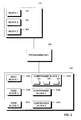
- a schematic view of a compression module is shown which is able to generate compressed navigation map data from uncompressed navigation map data.
- the compression module comprises a first database 110 in which the different blocks of data 111 are stored.
- the map data stored in database 110 cover a certain geographical area.
- the navigation map data may be divided into different geographical regions, e.g. by dividing the geographical area into tiles.
- the separation into different geographical regions is not reflected by the embodiment shown.
- the separation of the navigation map data is carried out in view of the functional aspect of the map data.
- the first block shown in Fig. 1 may be a routing building block, the routing building block grouping together the features of the map data that are used for routing applications.
- the routing building block may contain a representation of the road network to be used for calculating routes.
- the second building block shown in Fig. 1 may be a name building block providing inter alia the names to the different objects shown on the map.
- Building block 3 shown in Fig. 1 may be a map display building block grouping together the features for map display application. It may contain the features necessary for providing a two-dimensional map together with their geometrical data. It should be understood that many more building blocks may be provided in the database 110, e.g. a traffic information building block, a PoI (Point of Interest) building block, a speech building block, a 3D objects building block, etc.
- a traffic information building block e.g. a traffic information building block, a PoI (Point of Interest) building block, a speech building block, a 3D objects building block, etc.
- a processing unit 100 accesses the first database and processes each of the blocks 111 in such a way that it precalculates the most frequent substrings contained in each block.
- the pieces of information stored in the blocks are strings.
- the processing unit will identify a number of most frequent substrings in each block.
- the number of most frequent substrings of a block may depend on the number of strings contained in each block and the type of data may e.g. vary between 100 and around 5000.
- the most frequent substring may be determined by generating, for each block, a prefix tree, and by identifying in this prefix tree the most frequent substrings.
- the processing unit 100 will now replace the determined most frequent substrings which occur in the different blocks 111 by references to a block named seed block in which the determined most frequent substrings are stored. This seed block with the most frequent substrings can play the role of a (virtual) prefix of the data to be compressed.
- the processing unit stores the compressed data in a second database. As shown in Fig. 1 , for block 111 a seed block 121a comprising the most frequent substrings of block 1 is generated and the compressed block 122a in which the most frequent substrings contained in the seed block 121a are replaced by a reference to the seed block 121a.
- the reference furthermore contains an offset information indicating at which position within the seed block the omitted substring is stored. Furthermore, the reference contains a length information indicating the length of the replaced substrings. Furthermore, for block 2 of database 110 a seed block 121b is generated and a compressed block 122b. Seed block 121c comprises the most frequent substrings of block 3 and the compressed block 122c comprises the other non-replaced strings together with the references to the seed block.
- compressed navigation map data are generated for each of the building blocks contained in the first storage unit 110.
- the compressed block and the seed block are not necessarily generated for each of the blocks contained in database 110.
- the compressed block and the seed block are not necessarily generated for each of the blocks contained in database 110.
- the compression of such a block may be omitted.
- one seed block is generated for each building block.
- the most frequent substrings of two or more building blocks are stored in a single seed block.
- one seed block such as seed block 121a would comprise the most frequent substrings of compressed block 1 and compressed block 2.
- the blocks 111, before compression are separated into different parts wherein the most frequent substrings are determined for each of the different parts of a building block so that for each compressed block compressed parts are generated such as part 125, 126 and 127 in Fig. 1 .
- the most frequent substrings of the different compressed parts 125-127 are stored in one seed block.
- the separation for compressed block in different compressed parts may be combined with embodiment where the most frequent substrings of more than one building block are stored in a single seed block.
- the compressed parts of compressed block 1 and e.g. of the compressed parts of compressed block 2 would be stored in a single seed block.
- a seed block is generated for each compressed block containing the compressed parts.
- Fig. 2 the steps carried out for generating the compressed navigation map data are summarized.
- the method starts in step 20 and in step 21 the most frequent substrings are determined for the strings contained in a block.
- step 22 the most frequent substrings determined in step 21 are stored and grouped together in a seed block. Furthermore, when the number of substrings to be stored in the seed block is determined, these substrings are replaced in the block by the reference to the seed block (step 23).
- step 24 the seed block and the compressed block are then stored. The method ends on step 25.
- first database 110 and the second database 120 are shown as separate entities. It should be understood that the first database and the second database may be represented by a single physical storage unit, so that the uncompressed blocks 111 are stored on the same physical storage unit as the corresponding compressed data.
- the compressed navigation map data stored in the storage unit 120 can be used by a navigation system shown in Fig. 3 .
- the navigation system 300 shown in Fig. 3 comprises a storage unit 310 in which the compressed navigation map data with the seed blocks 121 and the corresponding compressed blocks 122 are stored.
- the data stored in database 310 can correspond to the data stored in database 120 of Fig. 1 .
- the database 310 may comprise anyone or any combination of various types of storage or memory media, such as random access memory, flash memory or a hard drive, but also a removable memory, such as a compact disk, a DVD, a memory card or the like.
- the navigation system furthermore contains a route calculation unit 320 which is configured to calculate the fastest or shortest route from a first location to a second location.
- a user can control the functioning of the navigation system via input unit 330.
- the input unit may contain haptical devices such as buttons that can be pressed or turned.
- the input unit can furthermore contain a speech recognition module allowing to control the functioning of the navigation system using speech commands.
- the information calculated by the route calculation unit can be displayed on a display 340.
- driving recommendations may also be output using voice commands.
- An antenna 350 receiving satellite signals can be provided where signals are received that are used to calculate the position of the navigation system.
- the way how a navigation system calculates a route from a defined location to a desired destination is known in the art and will not be explained in detail. For the sake of clarity only the components of the navigation system are indicated which are helpful for the understanding of the invention. It should be understood that the navigation system may contain different modules and further features not indicated in the schematic view of Fig. 3 .
- modules may be incorporated by software or hardware or by a combination of software and hardware.
- the navigation system furthermore comprises a decompression unit which decompresses the navigation data stored in database 310 before they can be used by the route calculation unit or before they can be displayed on display 340.
- the decompression unit replaces in the compressed blocks 122a, 122b the references by the substrings stored in the corresponding seed blocks 121a, 121b.
- the seed block or substring block is used as a virtual prefix of the compressed data block when it has been stored with the seed block as virtual prefix.
- the decompression of the navigation map data is not possible without the seed block.
- the use of a seed block and the compressed block for the different functional blocks provides an encryption to the data as the navigation data cannot be used without the corresponding seed blocks.
- a first encryption is obtained when the seed block is stored separate from the compressed blocks. Furthermore it is possible to store the seed block or seed blocks together with the compressed blocks and to encrypt the seed blocks using known encryption methods such as AES (Advanced Encryption Standard) or RSA (Rivest Shamir and Adleman Encryption).
- AES Advanced Encryption Standard
- RSA Raster Shamir and Adleman Encryption
- Fig. 4 the different steps for decompression are summarized.
- the method starts in step 40 and in step 41 a seed block is accessed, and the compressed block is accessed in step 42.
- the substrings that were replaced by a reference are identified in the corresponding seed block and the replaced substring is again introduced into the compressed block in order to generate the uncompressed block (step 43).
- the navigation information to be output to the user can be generated in step 44.
- the method ends in step 45.
- the invention provides an efficient compression of navigation map data.
- the compression method provides an encryption of the data, as the navigation map data cannot be used without the corresponding seed blocks.
- the information provided in a seed block may furthermore be encrypted using known encryption methods.
Priority Applications (7)
| Application Number | Priority Date | Filing Date | Title |
|---|---|---|---|
| EP11185269.5A EP2581704A1 (de) | 2011-10-14 | 2011-10-14 | Verfahren zur Kompression von Navigationskartendaten |
| CA2791033A CA2791033A1 (en) | 2011-10-14 | 2012-09-26 | Compressed navigation map data |
| KR1020120111661A KR102050576B1 (ko) | 2011-10-14 | 2012-10-09 | 압축된 내비게이션 지도 데이터 |
| BRBR102012026011-5A BR102012026011A2 (pt) | 2011-10-14 | 2012-10-10 | Dados de mapa de navegação comprimidos |
| US13/651,984 US20160320196A9 (en) | 2011-10-14 | 2012-10-15 | Compressed navigation map data |
| CN2012103891051A CN103047988A (zh) | 2011-10-14 | 2012-10-15 | 压缩的导航地图数据 |
| JP2012228051A JP6116185B2 (ja) | 2011-10-14 | 2012-10-15 | 圧縮ナビゲーション地図データ |
Applications Claiming Priority (1)
| Application Number | Priority Date | Filing Date | Title |
|---|---|---|---|
| EP11185269.5A EP2581704A1 (de) | 2011-10-14 | 2011-10-14 | Verfahren zur Kompression von Navigationskartendaten |
Publications (1)
| Publication Number | Publication Date |
|---|---|
| EP2581704A1 true EP2581704A1 (de) | 2013-04-17 |
Family
ID=44905491
Family Applications (1)
| Application Number | Title | Priority Date | Filing Date |
|---|---|---|---|
| EP11185269.5A Withdrawn EP2581704A1 (de) | 2011-10-14 | 2011-10-14 | Verfahren zur Kompression von Navigationskartendaten |
Country Status (7)
| Country | Link |
|---|---|
| US (1) | US20160320196A9 (de) |
| EP (1) | EP2581704A1 (de) |
| JP (1) | JP6116185B2 (de) |
| KR (1) | KR102050576B1 (de) |
| CN (1) | CN103047988A (de) |
| BR (1) | BR102012026011A2 (de) |
| CA (1) | CA2791033A1 (de) |
Cited By (1)
| Publication number | Priority date | Publication date | Assignee | Title |
|---|---|---|---|---|
| DE102013209168A1 (de) * | 2013-05-17 | 2014-11-20 | Bayerische Motoren Werke Aktiengesellschaft | Verfahren zum Betreiben eines Navigationssystems, Navigationssystem und Kraftfahrzeug |
Families Citing this family (26)
| Publication number | Priority date | Publication date | Assignee | Title |
|---|---|---|---|---|
| US8811431B2 (en) | 2008-11-20 | 2014-08-19 | Silver Peak Systems, Inc. | Systems and methods for compressing packet data |
| US8489562B1 (en) | 2007-11-30 | 2013-07-16 | Silver Peak Systems, Inc. | Deferred data storage |
| US8929402B1 (en) * | 2005-09-29 | 2015-01-06 | Silver Peak Systems, Inc. | Systems and methods for compressing packet data by predicting subsequent data |
| US8755381B2 (en) | 2006-08-02 | 2014-06-17 | Silver Peak Systems, Inc. | Data matching using flow based packet data storage |
| US8885632B2 (en) | 2006-08-02 | 2014-11-11 | Silver Peak Systems, Inc. | Communications scheduler |
| US8307115B1 (en) | 2007-11-30 | 2012-11-06 | Silver Peak Systems, Inc. | Network memory mirroring |
| US8743683B1 (en) | 2008-07-03 | 2014-06-03 | Silver Peak Systems, Inc. | Quality of service using multiple flows |
| US10805840B2 (en) | 2008-07-03 | 2020-10-13 | Silver Peak Systems, Inc. | Data transmission via a virtual wide area network overlay |
| US9717021B2 (en) | 2008-07-03 | 2017-07-25 | Silver Peak Systems, Inc. | Virtual network overlay |
| US10164861B2 (en) | 2015-12-28 | 2018-12-25 | Silver Peak Systems, Inc. | Dynamic monitoring and visualization for network health characteristics |
| US9130991B2 (en) | 2011-10-14 | 2015-09-08 | Silver Peak Systems, Inc. | Processing data packets in performance enhancing proxy (PEP) environment |
| US9626224B2 (en) | 2011-11-03 | 2017-04-18 | Silver Peak Systems, Inc. | Optimizing available computing resources within a virtual environment |
| US9948496B1 (en) | 2014-07-30 | 2018-04-17 | Silver Peak Systems, Inc. | Determining a transit appliance for data traffic to a software service |
| US9875344B1 (en) | 2014-09-05 | 2018-01-23 | Silver Peak Systems, Inc. | Dynamic monitoring and authorization of an optimization device |
| KR102258844B1 (ko) * | 2015-12-30 | 2021-05-28 | 에스케이플래닛 주식회사 | 네비게이션서비스장치 및 그 동작 방법 |
| US10432484B2 (en) | 2016-06-13 | 2019-10-01 | Silver Peak Systems, Inc. | Aggregating select network traffic statistics |
| US9967056B1 (en) | 2016-08-19 | 2018-05-08 | Silver Peak Systems, Inc. | Forward packet recovery with constrained overhead |
| US10480951B2 (en) * | 2016-10-18 | 2019-11-19 | Microsoft Technology Licensing, Llc | Generating routes using information from trusted sources |
| WO2018126079A1 (en) * | 2016-12-30 | 2018-07-05 | DeepMap Inc. | High definition map and route storage management system for autonomous vehicles |
| US10771394B2 (en) | 2017-02-06 | 2020-09-08 | Silver Peak Systems, Inc. | Multi-level learning for classifying traffic flows on a first packet from DNS data |
| US10257082B2 (en) | 2017-02-06 | 2019-04-09 | Silver Peak Systems, Inc. | Multi-level learning for classifying traffic flows |
| US10892978B2 (en) | 2017-02-06 | 2021-01-12 | Silver Peak Systems, Inc. | Multi-level learning for classifying traffic flows from first packet data |
| US11044202B2 (en) | 2017-02-06 | 2021-06-22 | Silver Peak Systems, Inc. | Multi-level learning for predicting and classifying traffic flows from first packet data |
| US11212210B2 (en) | 2017-09-21 | 2021-12-28 | Silver Peak Systems, Inc. | Selective route exporting using source type |
| US10637721B2 (en) | 2018-03-12 | 2020-04-28 | Silver Peak Systems, Inc. | Detecting path break conditions while minimizing network overhead |
| CN110048725B (zh) * | 2019-05-14 | 2023-07-07 | 四川九洲空管科技有限责任公司 | 一种基于taws系统的地形数据压缩解压缩算法 |
Citations (3)
| Publication number | Priority date | Publication date | Assignee | Title |
|---|---|---|---|---|
| US6670897B1 (en) * | 2002-10-03 | 2003-12-30 | Motorola, Inc. | Compression/decompression techniques based on tokens and Huffman coding |
| US20050288836A1 (en) * | 2004-03-16 | 2005-12-29 | Glass Paul M | Geographic information data base engine |
| WO2011095603A2 (en) * | 2010-02-04 | 2011-08-11 | Tomtom International B.V. | Map storage for navigation systems |
Family Cites Families (21)
| Publication number | Priority date | Publication date | Assignee | Title |
|---|---|---|---|---|
| US6393149B2 (en) * | 1998-09-17 | 2002-05-21 | Navigation Technologies Corp. | Method and system for compressing data and a geographic database formed therewith and methods for use thereof in a navigation application program |
| US6829690B1 (en) * | 2000-05-23 | 2004-12-07 | Navteq North America, Llc | Method and system for accessing spatially organized geographic data in blocks |
| JP2002311821A (ja) * | 2001-04-13 | 2002-10-25 | Mitsubishi Electric Corp | ナビゲーションにおける地図表示方法およびナビゲーション装置 |
| US6978206B1 (en) * | 2002-06-21 | 2005-12-20 | Infogation Corporation | Distributed navigation system |
| US7054888B2 (en) * | 2002-10-16 | 2006-05-30 | Microsoft Corporation | Optimizing media player memory during rendering |
| EP1544829B1 (de) * | 2003-12-19 | 2017-02-15 | Samsung Electronics Co., Ltd. | Navigationssystem und -verfahren |
| JP3842799B2 (ja) * | 2004-06-15 | 2006-11-08 | 株式会社ザナヴィ・インフォマティクス | 地図データ提供装置 |
| US20060064671A1 (en) * | 2004-09-20 | 2006-03-23 | Klaus Herter | Creating and using a building block |
| WO2006123429A1 (ja) * | 2005-05-20 | 2006-11-23 | Fujitsu Limited | 情報検索方法、装置、プログラム、該プログラムを記録した記録媒体 |
| US7512487B1 (en) * | 2006-11-02 | 2009-03-31 | Google Inc. | Adaptive and personalized navigation system |
| US7769729B2 (en) * | 2007-05-21 | 2010-08-03 | Sap Ag | Block compression of tables with repeated values |
| US20090216732A1 (en) * | 2008-02-27 | 2009-08-27 | Kyte Feng | Method and apparatus for navigation system for searching objects based on multiple ranges of desired parameters |
| JP5782214B2 (ja) * | 2008-05-30 | 2015-09-24 | 富士通株式会社 | 情報検索プログラム、情報検索装置および情報検索方法 |
| US8214404B2 (en) * | 2008-07-11 | 2012-07-03 | Avere Systems, Inc. | Media aware distributed data layout |
| US7669147B1 (en) * | 2009-01-02 | 2010-02-23 | International Business Machines Corporation | Reorienting navigation trees based on semantic grouping of repeating tree nodes |
| JP5054734B2 (ja) * | 2009-06-26 | 2012-10-24 | クラリオン株式会社 | カーナビゲーション装置、プログラムおよび地図データ更新方法 |
| US20110087425A1 (en) * | 2009-10-08 | 2011-04-14 | Telenav, Inc. | Navigation system with map compression and method of operation thereof |
| KR20110093258A (ko) * | 2010-02-12 | 2011-08-18 | 삼성전자주식회사 | 맵 데이터 송수신 장치 및 방법 |
| EP2574211A1 (de) * | 2010-03-09 | 2013-04-03 | David Schnitt | System zur einheitlichen verwaltung von elektronischen formularen |
| US20120191231A1 (en) * | 2010-05-04 | 2012-07-26 | Shazam Entertainment Ltd. | Methods and Systems for Identifying Content in Data Stream by a Client Device |
| US9690770B2 (en) * | 2011-05-31 | 2017-06-27 | Oracle International Corporation | Analysis of documents using rules |
-
2011
- 2011-10-14 EP EP11185269.5A patent/EP2581704A1/de not_active Withdrawn
-
2012
- 2012-09-26 CA CA2791033A patent/CA2791033A1/en not_active Abandoned
- 2012-10-09 KR KR1020120111661A patent/KR102050576B1/ko active IP Right Grant
- 2012-10-10 BR BRBR102012026011-5A patent/BR102012026011A2/pt not_active Application Discontinuation
- 2012-10-15 JP JP2012228051A patent/JP6116185B2/ja active Active
- 2012-10-15 CN CN2012103891051A patent/CN103047988A/zh active Pending
- 2012-10-15 US US13/651,984 patent/US20160320196A9/en not_active Abandoned
Patent Citations (3)
| Publication number | Priority date | Publication date | Assignee | Title |
|---|---|---|---|---|
| US6670897B1 (en) * | 2002-10-03 | 2003-12-30 | Motorola, Inc. | Compression/decompression techniques based on tokens and Huffman coding |
| US20050288836A1 (en) * | 2004-03-16 | 2005-12-29 | Glass Paul M | Geographic information data base engine |
| WO2011095603A2 (en) * | 2010-02-04 | 2011-08-11 | Tomtom International B.V. | Map storage for navigation systems |
Cited By (2)
| Publication number | Priority date | Publication date | Assignee | Title |
|---|---|---|---|---|
| DE102013209168A1 (de) * | 2013-05-17 | 2014-11-20 | Bayerische Motoren Werke Aktiengesellschaft | Verfahren zum Betreiben eines Navigationssystems, Navigationssystem und Kraftfahrzeug |
| US9983019B2 (en) | 2013-05-17 | 2018-05-29 | Bayerische Motoren Werke Aktiengesellschaft | Method for operating a navigation system, navigation system and motor vehicle |
Also Published As
| Publication number | Publication date |
|---|---|
| US20160320196A9 (en) | 2016-11-03 |
| JP2013088815A (ja) | 2013-05-13 |
| KR102050576B1 (ko) | 2019-11-29 |
| CN103047988A (zh) | 2013-04-17 |
| BR102012026011A2 (pt) | 2013-11-26 |
| JP6116185B2 (ja) | 2017-04-19 |
| CA2791033A1 (en) | 2013-04-14 |
| US20140108360A1 (en) | 2014-04-17 |
| KR20130040707A (ko) | 2013-04-24 |
Similar Documents
| Publication | Publication Date | Title |
|---|---|---|
| EP2581704A1 (de) | Verfahren zur Kompression von Navigationskartendaten | |
| EP3077769B1 (de) | Verfahren zum auflösen eines punktortes aus dafür repräsentativen codierten daten | |
| US7949467B2 (en) | Road map data structure, road map data structure creating method, road map data storage medium, and navigation device | |
| EP3051259B1 (de) | Navigationssystem mit kartenaktualisierungsmechanismus und bedienungsverfahren dafür | |
| CA2652503A1 (en) | Data updating system, terminal device, server, and method of data updating | |
| CN102947676A (zh) | 导航装置及在其上实行的方法 | |
| US20080208459A1 (en) | Road-map-data configuration and navigation apparatus | |
| JP5421949B2 (ja) | 交通量予測装置、交通量予測方法およびプログラム | |
| US9851210B2 (en) | Map information processing apparatus, map information processing method, and method for adjusting update data | |
| EP3153818B1 (de) | Verfahren und systeme zur bereitstellung von kartendaten einer navigationsvorrichtung | |
| US9441983B2 (en) | Navigation system with content curation mechanism and method of operation thereof | |
| US11692839B2 (en) | Methods and apparatuses for providing navigation instructions | |
| EP3040855A1 (de) | Aktualisierung von in listen organisierten navigationskartendaten | |
| US20110191016A1 (en) | Map data, storage medium and navigation apparatus | |
| US10409842B2 (en) | Storage medium, map information processing apparatus, and data generation method | |
| US20110191357A1 (en) | Map data, storage medium and navigation apparatus | |
| EP1884742A2 (de) | Routensuchsystem, Vorrichtung zum Erzeugen von Straßendaten, Routensuchdaten, Serverprogramm und Routensuchverfahren | |
| EP2518446A1 (de) | Fahrzeugnavigationssystem mit Anzeige einer Fahrbahnmarkierung | |
| US20090234877A1 (en) | Method for creating a directory of road sections, method for ascertaining all road sections within a search area, and computer program | |
| CN104067331A (zh) | 地图数据构造、地图数据制作方法、以及车载信息终端装置 | |
| US10282365B2 (en) | Reducing changes to a compiled database | |
| US20130002658A1 (en) | Vehicle navigation device and method | |
| CN113494919B (zh) | 基于个人局部经验路线的导航规划方法和装置 | |
| US20220092092A1 (en) | Method, apparatus, and computer program product for updating a map database using subtree data structures | |
| WO2018200699A2 (en) | Computing system with genomic information access mechanism and method of operation thereof |
Legal Events
| Date | Code | Title | Description |
|---|---|---|---|
| PUAI | Public reference made under article 153(3) epc to a published international application that has entered the european phase |
Free format text: ORIGINAL CODE: 0009012 |
|
| AK | Designated contracting states |
Kind code of ref document: A1 Designated state(s): AL AT BE BG CH CY CZ DE DK EE ES FI FR GB GR HR HU IE IS IT LI LT LU LV MC MK MT NL NO PL PT RO RS SE SI SK SM TR |
|
| AX | Request for extension of the european patent |
Extension state: BA ME |
|
| 17P | Request for examination filed |
Effective date: 20131017 |
|
| 17Q | First examination report despatched |
Effective date: 20180601 |
|
| STAA | Information on the status of an ep patent application or granted ep patent |
Free format text: STATUS: THE APPLICATION IS DEEMED TO BE WITHDRAWN |
|
| 18D | Application deemed to be withdrawn |
Effective date: 20200923 |