EP2573518A1 - Terminal location specifying system, mobile terminal and terminal location specifying method - Google Patents
Terminal location specifying system, mobile terminal and terminal location specifying method Download PDFInfo
- Publication number
- EP2573518A1 EP2573518A1 EP11783419A EP11783419A EP2573518A1 EP 2573518 A1 EP2573518 A1 EP 2573518A1 EP 11783419 A EP11783419 A EP 11783419A EP 11783419 A EP11783419 A EP 11783419A EP 2573518 A1 EP2573518 A1 EP 2573518A1
- Authority
- EP
- European Patent Office
- Prior art keywords
- landmark
- mobile terminal
- information
- approximate position
- terminal
- Prior art date
- Legal status (The legal status is an assumption and is not a legal conclusion. Google has not performed a legal analysis and makes no representation as to the accuracy of the status listed.)
- Withdrawn
Links
Images


Classifications
-
- H—ELECTRICITY
- H04—ELECTRIC COMMUNICATION TECHNIQUE
- H04N—PICTORIAL COMMUNICATION, e.g. TELEVISION
- H04N7/00—Television systems
- H04N7/18—Closed-circuit television [CCTV] systems, i.e. systems in which the video signal is not broadcast
-
- G—PHYSICS
- G01—MEASURING; TESTING
- G01C—MEASURING DISTANCES, LEVELS OR BEARINGS; SURVEYING; NAVIGATION; GYROSCOPIC INSTRUMENTS; PHOTOGRAMMETRY OR VIDEOGRAMMETRY
- G01C21/00—Navigation; Navigational instruments not provided for in groups G01C1/00 - G01C19/00
- G01C21/005—Navigation; Navigational instruments not provided for in groups G01C1/00 - G01C19/00 with correlation of navigation data from several sources, e.g. map or contour matching
-
- G—PHYSICS
- G01—MEASURING; TESTING
- G01C—MEASURING DISTANCES, LEVELS OR BEARINGS; SURVEYING; NAVIGATION; GYROSCOPIC INSTRUMENTS; PHOTOGRAMMETRY OR VIDEOGRAMMETRY
- G01C21/00—Navigation; Navigational instruments not provided for in groups G01C1/00 - G01C19/00
- G01C21/20—Instruments for performing navigational calculations
- G01C21/206—Instruments for performing navigational calculations specially adapted for indoor navigation
-
- G—PHYSICS
- G01—MEASURING; TESTING
- G01C—MEASURING DISTANCES, LEVELS OR BEARINGS; SURVEYING; NAVIGATION; GYROSCOPIC INSTRUMENTS; PHOTOGRAMMETRY OR VIDEOGRAMMETRY
- G01C21/00—Navigation; Navigational instruments not provided for in groups G01C1/00 - G01C19/00
- G01C21/26—Navigation; Navigational instruments not provided for in groups G01C1/00 - G01C19/00 specially adapted for navigation in a road network
- G01C21/28—Navigation; Navigational instruments not provided for in groups G01C1/00 - G01C19/00 specially adapted for navigation in a road network with correlation of data from several navigational instruments
-
- G—PHYSICS
- G01—MEASURING; TESTING
- G01C—MEASURING DISTANCES, LEVELS OR BEARINGS; SURVEYING; NAVIGATION; GYROSCOPIC INSTRUMENTS; PHOTOGRAMMETRY OR VIDEOGRAMMETRY
- G01C21/00—Navigation; Navigational instruments not provided for in groups G01C1/00 - G01C19/00
- G01C21/26—Navigation; Navigational instruments not provided for in groups G01C1/00 - G01C19/00 specially adapted for navigation in a road network
- G01C21/34—Route searching; Route guidance
- G01C21/36—Input/output arrangements for on-board computers
- G01C21/3602—Input other than that of destination using image analysis, e.g. detection of road signs, lanes, buildings, real preceding vehicles using a camera
-
- G—PHYSICS
- G01—MEASURING; TESTING
- G01C—MEASURING DISTANCES, LEVELS OR BEARINGS; SURVEYING; NAVIGATION; GYROSCOPIC INSTRUMENTS; PHOTOGRAMMETRY OR VIDEOGRAMMETRY
- G01C21/00—Navigation; Navigational instruments not provided for in groups G01C1/00 - G01C19/00
- G01C21/26—Navigation; Navigational instruments not provided for in groups G01C1/00 - G01C19/00 specially adapted for navigation in a road network
- G01C21/34—Route searching; Route guidance
- G01C21/36—Input/output arrangements for on-board computers
- G01C21/3679—Retrieval, searching and output of POI information, e.g. hotels, restaurants, shops, filling stations, parking facilities
-
- G—PHYSICS
- G01—MEASURING; TESTING
- G01S—RADIO DIRECTION-FINDING; RADIO NAVIGATION; DETERMINING DISTANCE OR VELOCITY BY USE OF RADIO WAVES; LOCATING OR PRESENCE-DETECTING BY USE OF THE REFLECTION OR RERADIATION OF RADIO WAVES; ANALOGOUS ARRANGEMENTS USING OTHER WAVES
- G01S5/00—Position-fixing by co-ordinating two or more direction or position line determinations; Position-fixing by co-ordinating two or more distance determinations
- G01S5/0009—Transmission of position information to remote stations
- G01S5/0018—Transmission from mobile station to base station
-
- G—PHYSICS
- G08—SIGNALLING
- G08G—TRAFFIC CONTROL SYSTEMS
- G08G1/00—Traffic control systems for road vehicles
- G08G1/005—Traffic control systems for road vehicles including pedestrian guidance indicator
-
- G—PHYSICS
- G08—SIGNALLING
- G08G—TRAFFIC CONTROL SYSTEMS
- G08G1/00—Traffic control systems for road vehicles
- G08G1/123—Traffic control systems for road vehicles indicating the position of vehicles, e.g. scheduled vehicles; Managing passenger vehicles circulating according to a fixed timetable, e.g. buses, trains, trams
- G08G1/127—Traffic control systems for road vehicles indicating the position of vehicles, e.g. scheduled vehicles; Managing passenger vehicles circulating according to a fixed timetable, e.g. buses, trains, trams to a central station ; Indicators in a central station
- G08G1/13—Traffic control systems for road vehicles indicating the position of vehicles, e.g. scheduled vehicles; Managing passenger vehicles circulating according to a fixed timetable, e.g. buses, trains, trams to a central station ; Indicators in a central station the indicator being in the form of a map
-
- G—PHYSICS
- G01—MEASURING; TESTING
- G01S—RADIO DIRECTION-FINDING; RADIO NAVIGATION; DETERMINING DISTANCE OR VELOCITY BY USE OF RADIO WAVES; LOCATING OR PRESENCE-DETECTING BY USE OF THE REFLECTION OR RERADIATION OF RADIO WAVES; ANALOGOUS ARRANGEMENTS USING OTHER WAVES
- G01S5/00—Position-fixing by co-ordinating two or more direction or position line determinations; Position-fixing by co-ordinating two or more distance determinations
- G01S5/02—Position-fixing by co-ordinating two or more direction or position line determinations; Position-fixing by co-ordinating two or more distance determinations using radio waves
- G01S5/0257—Hybrid positioning
- G01S5/0258—Hybrid positioning by combining or switching between measurements derived from different systems
- G01S5/02585—Hybrid positioning by combining or switching between measurements derived from different systems at least one of the measurements being a non-radio measurement
Definitions
- the present invention relates to a terminal location specifying system, a mobile terminal, and a terminal location specifying method.
- a service using AR Augmented Reality
- a technique that acquires an object placed in the vicinity of the located position of a mobile terminal and displays an object including various information and images superimposed on an image acquired by a camera included in the mobile terminal is known.
- an object to be superimposed is selected based on the located position of the mobile terminal.
- the mobile terminal displays an object based on a positional relationship between the located position of the terminal itself and the position of the object. It is thus important in this technique to accurately detect the located position of the mobile terminal.
- a technique that acquires the position of an arbitrary landmark object captured by a camera included in a terminal device from a database that pre-stores the positional information of landmark objects and calculates the position of the terminal device based on the acquired position of the landmark object is known (for example, see Patent Literature 1).
- the position of the terminal device cannot be specified unless information about a landmark object photographed by the terminal device does not exist in the database. Further, the volume of a database becomes enormous if the database stores information about all structures that can be a landmark object in order to specify the position of the terminal device based on a landmark object that is randomly photographed.
- the present invention has been accomplished to solve the above problems and an object of the present invention is thus to provide a terminal location specifying system, a mobile terminal, and a terminal location specifying method that can accurately and reliably specify the position of the mobile terminal in the AR technology.
- a terminal location specifying system for specifying a position of a mobile terminal, the system including the mobile terminal and a server capable of communicating with the mobile terminal, the mobile terminal including an approximate position measurement means for measuring an approximate position where the mobile terminal is located, an approximate position information transmitting means for transmitting approximate position information about the approximate position measured by the approximate position measurement means to the server, a landmark information receiving means for receiving landmark information about a landmark from the server, the landmark being a photographing object to be photographed by the mobile terminal for specifying the position of the mobile terminal, a landmark photographing means for photographing the landmark indicated by the landmark information received by the landmark information, receiving means, a landmark image transmitting means for transmitting a landmark image being an image of the landmark photographed by the landmark photographing means to the server, a position information receiving means for receiving terminal position information indicating a position of the mobile terminal when the landmark image has been photographed from the server, and a position information management means for managing a position indicated by the terminal position
- a mobile terminal in a terminal location specifying system for specifying a position of a mobile terminal, the system including the mobile terminal and a server capable of communicating with the mobile terminal, the mobile terminal including an approximate position measurement means for measuring an approximate position where the mobile terminal is located, an approximate position information transmitting means for transmitting approximate position information about the approximate position measured by the approximate position measurement means to the server, a landmark information receiving means for receiving landmark information about a landmark from the server, the landmark being a photographing object to be photographed by the mobile terminal for specifying the position of the mobile terminal, a landmark photographing means for photographing the landmark indicated by the landmark information received by the landmark information receiving means, a landmark image transmitting means for transmitting a landmark image being an image of the landmark photographed by the landmark photographing means to the server, a position information receiving means for receiving terminal position information indicating a position of the mobile terminal when the landmark image has been photographed from the server, and a position information management means for managing a position indicated by the terminal
- a terminal location specifying method is a terminal location specifying method in a terminal location specifying system for specifying a position of a mobile terminal, the system including the mobile terminal and a server capable of communicating with the mobile terminal, the method including an approximate position measurement step of measuring an approximate position where the mobile terminal is located by the mobile terminal, an approximate position information transmitting step of transmitting approximate position information about the approximate position measured in the approximate position measurement step from the mobile terminal to the server, an approximate position information receiving step of receiving the approximate position information transmitted in the approximate position information transmitting step by the server, a landmark retrieval step of retrieving the landmark information of the landmark located within a pre-specified distance from the approximate position by the server based on the approximate position information received in the approximate position information receiving step by referring to a landmark information storage means storing a plurality of landmark information about a landmark being a photographing object to be photographed by the mobile terminal for specifying the position of the mobile terminal, a landmark information transmitting step of transmitting the landmark information
- the mobile terminal and the terminal location specifying method landmark information of a landmark located within a specified distance from an approximate position is retrieved based on approximate position information of the mobile terminal, and the retrieved landmark information is transmitted to the mobile terminal.
- the mobile terminal can thereby acquire the landmark information about the landmark located in the vicinity of the mobile terminal.
- the landmark information pre-stored in the server is transmitted to the mobile terminal, it is possible to reliably specify the position of the mobile terminal based on the landmark image.
- the photographing position of the image is analyzed based on the landmark image, and the photographing position is managed as the located position of the mobile terminal in the mobile terminal, and it is thus possible to accurately specify the position of the mobile terminal.
- the mobile terminal may further include a direction measurement means for measuring a viewing direction being a direction of sight in the landmark photographing means, and the approximate position information transmitting means may transmit information about the viewing direction measured by the direction measurement means as direction information, together with the approximate position information, to the server, and the landmark retrieval means may retrieve the landmark information of the landmark located within a pre-specified distance from the approximate position indicated by the approximate position information and located in a specified angular range centering on the viewing direction indicated by the direction information from the landmark information storage means.
- the viewing direction in the landmark photographing means of the mobile terminal is transmitted to the server, the landmark information of the landmark located in the specified angular range centering on the viewing direction is extracted and transmitted to the mobile terminal.
- the landmark information of the landmark that can be photographed in the mobile terminal is thereby transmitted from the server to the mobile terminal.
- the landmark image can be reliably acquired, and it is possible to reliably specify the position of the mobile terminal.
- the server may further include a map data storage means for storming map data
- the landmark retrieval means may refer to the map data storage means and retrieve the landmark information of the landmark located within a pre-specified distance from the approximate position indicated by the approximate position information and where a shield does not exist between the approximate position and the landmark from the landmark information storage means.
- the landmark information of the landmark having no shield between the located position of the mobile terminal and the landmark is extracted based on the map data and transmitted to the mobile terminal.
- the landmark information of the landmark that can be photographed in the mobile terminal is thereby transmitted from the server to the mobile terminal.
- the landmark image can be reliably acquired, and it is possible to reliably specify the position of the mobile terminal.
- the landmark information may contain a visible angle being information indicating an angular range with respect to a facing direction of the landmark where the landmark is visible, and when the approximate position is located within the angular range indicated by the visible angle of the landmark, the landmark retrieval means may retrieve the landmark information of the landmark from the landmark information storage means.
- the landmark information of the landmark that is visible from the mobile terminal is transmitted from the server to the mobile terminal.
- the landmark image can be reliably acquired, and it is possible to reliably specify the position of the mobile terminal.
- the landmark retrieval means may retrieve the landmark information of the landmark where, when the landmark is photographed by the landmark photographing means, a legion size of an image of the landmark with respect to a whole photographed image is within a range of a prescribed size from the landmark information storage means.
- the landmark information of the landmark that is displayed in an appropriate size on the mobile terminal is transmitted from the server to the mobile terminal.
- the photographing of the landmark in the mobile terminal and the analysis of the position of the mobile terminal based on the landmark image become easy.
- the landmark information may contain landmark position information indicating a located position of the landmark
- the mobile terminal may further include a landmark guide means for displaying guide information providing a guide to the position of the landmark on a display means included in the mobile terminal based on a positional relationship between the approximate position of the mobile terminal and the located position of the landmark indicated by the landmark position information.
- the located position of the landmark is guided to a user through the display means of the mobile terminal, and the user can reliably recognize the position of the landmark. Accordingly, the photographing and acquisition of the landmark image can be performed easily.
- the landmark information may contain information about a height of a position where the landmark is located, and the landmark guide means may display the position and height of the landmark as the guide information on the display means.
- information about the height where the landmark is located is also guided to a user through the display means of the mobile terminal, and the user can more reliably recognize the position of the landmark. Accordingly, the photographing and acquisition of the landmark image are reliably performed.
- the terminal position analysis means may analyze the position of the mobile terminal when the landmark image has been photographed based on a difference between a position, size and shape of the landmark in a real space and a position, size and shape of the landmark in the landmark image. It is thereby possible to analyze the position of the mobile terminal with high accuracy.
- a terminal location specifying system for specifying a position of a mobile terminal, the system including the mobile terminal and a server capable of communicating with the mobile terminal, the mobile terminal including an approximate position measurement means for measuring an approximate position where the mobile terminal is located, an approximate position information transmitting means for transmitting approximate position information about the approximate position measured by the approximate position measurement means to the server, a landmark information receiving means for receiving landmark information about a landmark from the server, the landmark being a photographing object to be photographed by the mobile terminal for specifying the position of the mobile terminal, a landmark photographing means for photographing the landmark indicated by the landmark information received by the landmark information receiving means, a photographing position analysis means for analyzing a located position of the mobile terminal when a landmark image has been photographed based on the landmark image being an image of the landmark photographed by the landmark photographing means, a position information management means for managing information about the located position of the mobile terminal analyzed by the photographing position analysis means, and the server including an approximate position
- a mobile terminal is a mobile terminal in a terminal, location specifying system for specifying a position of a mobile terminal, the system including the mobile terminal and a server capable of communicating with the mobile terminal, the mobile terminal including an approximate position measurement means for measuring an approximate position where the mobile terminal is located, an approximate position information transmitting means for transmitting approximate position information about the approximate position measured by the approximate position measurement means to the server, a landmark information receiving means for receiving landmark information about a landmark from the server, the landmark being a photographing object to be photographed by the mobile terminal for specifying the position of the mobile terminal, a landmark photographing means for photographing the landmark indicated by the landmark information received by the landmark information receiving means, a photographing position analysis means for analysing a located position of the mobile terminal when a landmark image has been photographed based on the landmark image being an image of the landmark photographed by the landmark photographing means, a position information management means for managing information about the located position of the mobile terminal analyzed by the photographing position analysis means.
- a terminal location specifying method is a terminal location specifying method in a terminal location specifying system for specifying a position of a mobile terminal, the system including the mobile terminal and a server capable of communicating with the mobile terminal, the method including an approximate position measurement step of measuring an approximate position where the mobile terminal is located by the mobile terminal, an approximate position information transmitting step of transmitting approximate position information about the approximate position measured in the approximate position measurement step from the mobile terminal to the server an approximate position information receiving step of receiving the approximate position information transmitted in the approximate position information transmitting step by the server, a landmark retrieval step of retrieving the landmark information of the landmark located within a pre-specified distance from the approximate position by the server based on the approximate position information received in the approximate position information receiving step by referring to a landmark information storage means storing a plurality of landmark information about a landmark being a photographing object to be photographed by the mobile terminal for specifying the position of the mobile terminal, a landmark formation transmitting step of transmitting the landmark information
- the mobile terminal and the terminal location specifying method landmark information of a landmark located within a specified distance from an approximate position is retrieved based on approximate position information of the mobile terminal, and the retrieved landmark information is transmitted to the mobile terminal.
- the mobile terminal can thereby acquire the landmark information about the landmark located in the vicinity of the mobile terminal.
- the landmark information pre-stored in the server is transmitted to the mobile terminal, it is possible to reliably specify the position of the mobile terminal based on the landmark image.
- the photographing position of the image is analyzed based on the landmark image, and the photographing position is managed as the located position of the mobile terminal in the mobile terminal, and it is thus possible to accurately and easily specify the position of the mobile terminal.
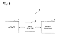
- Fig. 1 is a diagram showing a device configuration of a terminal location specifying system 7 according to a first embodiment.
- the terminal location specifying system 7 includes a mobile terminal and a server 3 that can communicate with the mobile terminal 1.
- the mobile terminal 1 is a portable terminal that can perform communication through a mobile communication network, for example.
- the mobile terminal 1 communicates with the server through a base station 5, which is a mobile communication network.
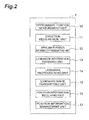
- Fig. 2 is a block diagram shewing a functional configuration of the mobile terminal 1 according to the first embodiment.
- the mobile terminal 1 according to this embodiment is a device that controls display of an object placed in the real space or the virtual space, for example, and has a function of acquiring an object placed in the vicinity of the located position of the mobile terminal 1 in the real space or the virtual space from the server and displaying an object including various information and images superimposed on an image in the real space acquired by a camera included in the mobile terminal 1.
- a display means such as a display of the mobile terminal 1
- the mobile terminal 1 includes, as functional components, an approximate position measurement unit 10 (approximate position measurement means), a direction measurement unit 11 (direction measurement means), an approximate position information transmitting unit 12 (approximate position information transmitting means), a landmark information receiving unit 13 (landmark information receiving means), a landmark photographing unit 14 (landmark photographing means), a landmark image transmitting unit 15 (landmark image transmitting means), a position information receiving unit 16 (position information receiving means), and a position information management unit 17 (position information management means).
- an approximate position measurement unit 10 approximately position measurement means
- a direction measurement unit 11 direction measurement means
- an approximate position information transmitting unit 12 approximately position information transmitting means
- a landmark information receiving unit 13 landmark information receiving means
- a landmark photographing unit 14 laandmark photographing means
- a landmark image transmitting unit 15 laandmark image transmitting means
- position information receiving unit 16 position information receiving means
- a position information management unit 17 position information management means
- Fig. 3 is a hardware block diagram of the mobile terminal 1.
- the mobile terminal 1 is physically configured as a computer system that includes a CPU 101, a RAM 102 and a ROM 103 which are a main storage device, a communication module 104 which is a data transmitting and receiving device, am auxiliary storage device 105 such as a hard disk or flash memory, an input device 106 such as a keyboard, an output device 107 such as a display and the like.
- the functions shown in Fig. 2 are implemented by loading given computer software onto hardware such as the CPU 101 or the RAM 102 shown in Fig.
- the approximate position measurement unit 10 is a part that measures an approximate position where the mobile terminal 1 is located.
- the approximate position measurement unit 10 may be a GPS device, for example.
- the position measurement by the GPS contains errors caused by the principle of measurement. Accordingly, a position measured by the approximate position measurement unit 10 is an approximate position.
- the approximate position measurement unit 10 sends approximate position information about the approximate position to the approximate position information transmitting unit 12.
- the direction measurement unit 11 is a part that measures a viewing direction, which is the line oaf sight in the landmark photographing unit 14.
- the direction measurement unit 11 sends information about the measured viewing direction as direction information to the approximate position information transmitting unit 12.
- the approximate position information transmitting unit 12 is a part that transmits the approximate position information about the approximate position measured by the approximate position measurement unit 10 to the server 3. Further, when the measurement of the viewing direction by the direction measurement unit 11 has been performed, the approximate position information transmitting unit 12 transmits the direction information, together with the approximate position information, to the server 3.
- the landmark information receiving unit 13 is a part that receives landmark information about a landmark from the server.
- the landmark is a photographing object that exists in the real space and is to be photographed by the mobile terminal, 1 for specifying the position of the mobile terminal 1.
- the landmark is a structure such as a specified building or signboard.
- the landmark information contains information about the located position of a landmark and object information for recognizing the outer appearance of a landmark. The landmark information is described in detail later.
- the landmark photographing unit 14 is a part that photographs a landmark indicated by the landmark information, and it may be a camera, for example. Because a user of the mobile terminal, 1 can recognize the located position or the like of a landmark based on the landmark information, the user can photograph the landmark by activating the landmark photographing unit 14. The landmark photographing unit 14 sends the image of the photographed landmark to the landmark image transmitting unit 15.
- the landmark image transmitting unit 15 is a part that transmits the landmark image acquired from the landmark photographing unit 14 to server 3.
- the position information receiving unit 16 is a part that receives terminal position information analyzed by the server 3 from the server 3.
- the terminal position information is information indicating the position of the mobile terminal when the landmark image has been photographed. The analysis of the terminal position information is described later.
- the position information management unit 17 is a part that managers a position indicated by the terminal position information received by the position information receiving unit 16 as the located position of the mobile terminal 1. Specifically, the position information management unit 17 uses a position indicated by the terminal position information as a reference position when displaying an object placed in the real space or the virtual space superimposed on an image of the real space acquired by the camera. The mobile terminal 1 acquires an object placed in the vicinity of the mobile terminal 1 tin the real space or the virtual space using a position indicated by the terminal position information as a reference position and displays the object based on a positional relationship between the reference position of the mobile terminal 1 and the position of the object.
- Fig. 4 is a block diagram showing a functional configuration or the server 3 according to the first embodiment.
- the server 3 according to this embodiment includes an approximate position information receiving unit 30 (approximate position information receiving means), a landmark information storage unlit 3 (landmark information storage means), a landmark retrieval unit 32 (landmark retrieval means), a landmark information transmitting unit 38 (landmark information transmitting means), a landmark image receiving unit 39 (landmark image receiving means), a terminal position analysis unit 40 (terminal position analysis means), a terminal position information transmitting unit 41 (terminal, position information transmitting means), and a map data storage unit 42 (map data storage means).
- the server 3 is a computer having a hardware configuration similar to the hardware configuration of the mobile terminal 1 shown in Fig. 3 .
- the respective functional units of the server 3 are described in detail with reference to Fig. 4 .
- the approximate position information receiving unit 30 is a part that receives the approximate position information transmitted from the mobile terminal 1. Further, when the direction information is transmitted together with the approximate position information from the approximate position information transmitting unit 12, the approximate position information receiving unit 30 receives the approximate position information and, the direction information. The approximate position information receiving unit 30 sends the received approximate position information and direction information to the landmark retrieval unit 32.
- the landmark information storage unit 31 is a part that stores landmark information.
- Fig. 5 is a diagram showing the configuration of the landmark information storage unit 31 and an example of data stored therein. As shown in Fig. 5 , the landmark information storage unit 31 stores, as landmark information, information about a position, name, object information, height information, direction, visible angle, and size in association with each item number.
- the "position” is information indicating the two-dimensional located position of a landmark.
- the “none” is information indicating the name of the landmark.
- the "object information” is two-dimensional or three-dimensional data that visually represents the shape of the landmark.
- the "height information” is information indicating the height of a position where the landmark is located.
- the "direction” is information about an angle indicating the direction which the landmark directly faces, and it increases as rotating clockwise, starting from the north as 0 degree.
- the “visible angle” is information indicating the angular range where the landmark is visible.
- the “horizontal” angular range in the visible angle is set with respect to the direction which the landmark directly faces. Further, the “vertical” angular range in the visible angle is set with respect to the horizontal direction.
- the "size” is information indicating the size of the outer shape of the landmark.
- the landmark retrieval unit 32 is a part that retrieves landmark information of a landmark as a photographing object suitable for specifying the position of the mobile terminal 1 from the landmark information storage unit 31.
- the landmark retrieval unit 32 includes a landmark extraction unit 33, a mobile direction check unit 34, a visible angle check unit 35, a display size check unit 36, and a shield retrieval unit 37, as shown in Fig. 4 .
- the landmark extraction unit 33 is a part that extracts landmark information of a landmark located within a pre-specified distance from the approximate position from the landmark information storage unit 31 based on the approximate position information of the mobile terminal 1 and information about the "position" in the landmark information storage unit 31.
- the mobile direction check unit 34 is a part that checks whether the landmark extracted by the landmark extraction unit 33 is located in the specified angular range centering can the viewing direction of the mobile terminal 1 based on the direction information and the approximate position information from the mobile terminal 1 and information about the "position" in the landmark information storage unit 31.
- the visible angle check unit 35 is a part that checks whether the landmark extracted by the landmark extraction unit 33 is a landmark that is visible from the located position of the mobile terminal 1 based on the approximate position information and the "visible angle" in the landmark information storage unit 31.
- Fig. 6 is a diagram showing a positional relationship between a user P having the mobile terminal 1 and a landmark. Because the user P has the mobile terminal is the located position of the user P is substantially equal to the approximate position of the mobile terminal 1. In Fig. 6 , although the located position of the user P is included in the visible angle of the landmark L c , it is not included in the visible angle of the landmark L B . Thus, the visible angle check unit 35 determines the landmark L C as a landmark visible from the located position of the mobile terminal 1 and determines the landmark L B as a landmark not visible from the located position of the mobile terminal 1.
- the display size check unit 36 is a part that checks whether, the landmark extracted by the landmark extraction unit 33 is a landmark where, when a landmark photographed by the landmark photographing unit 14 of the mobile terminal 1 is displayed can a display unit (not shown) of the mobile terminal 1, the size of a region occupied by the image of the landmark with respect to the whole image on the display unit is within the range of a predetermined size.
- the size of a region occupied by the image of the landmark on the display unit depends on the distance between the mobile terminal 1 and the landmark and the magnification when the landmark photographing unit 14 captures the landmark.
- the landmark image for specifying the position of the mobile terminal 1 is preferably displayed in an appropriate size on the display unit.
- the landmark information of a landmark suitable for photographing is extracted by the display size check unit 36.
- the shield retrieval unit 37 is a part that checks whether the landmark extracted by the landmark extraction unit 33 is a landmark with no shield between the approximate position of the mobile terminal 1 and the landmark based on the map data stored in the map data storage unit 42 and the approximate position information. Referring to Fig. 6 , although a shield does not exist between the landmark L C and the user P, a shield C A exists between the landmark L A and the user P. Thus, the shield retrieval unit 37 determines the landmark L C as a landmark with no shield between the approximate position of the mobile terminal 1 and the landmark, and determines the landmark L A as a landmark with a shield between the approximate position or the mobile terminal, 1 and the landmark.
- the mobile terminal 1 may transmit photographing information related to a photograph viewing angle, focal length, magnification and the like when the landmark photographing unit 14 captures the image of a landmark to the server 3.
- the landmark retrieval unit 32 acquires the photographing information transmitted from the mobile terminal 1.
- the landmark retrieval unit 32 can chance thresholds related to the "visible angle" used for checking by the visible angle check unit 35 and the display size used for checking by the display size check unit 36 in accordance with the photographing information.
- the photographing information may be stored in advance in the server 3.
- the landmark retrieval unit 32 sends the landmark information extracted by the functional unites 33 to 37 to the landmark information transmitting unit 38.
- the landmark retrieval unit 32 performs the checking and extraction of the landmark information using the landmark extraction unit 33, the mobile direction check unit 34, the visible angle check unit 35, the display size check unit 36 and the shield retrieval unit 37 in this order, the order is not particularly limited.
- the landmark information transmitting unit 38 is a part that transmits the landmark information retrieved by the landmark retrieval unit 32 to the mobile terminal 1.
- the landmark image receiving unit 39 is a part that receives the landmark image transmitted from the mobile terminal 1.
- the terminal position analysis unit 40 is a part that analyzes and calculates the position of the mobile terminal 1 at the time when the landmark image has been photographed based on the landmark image received by the landmark image receiving unit 39. Specifically, the terminal position analysis unit 40 analyzes the position of the mobile terminal 1 at the time when the landmark image has been photographed based on a difference between the position, size and shape of the landmark in the real space extracted from the landmark information storage unit 31 and the position, size and shape of the landmark in the landmark image.
- the terminal, position information transmitting unit 4 is a part that transmits the position of the mobile terminal 1 analyzes by the terminal position analysis unit 40 as terminal position information to the mobile terminal.
- the map data storage unit 42 is a part that stores map data.
- the map data contains road shapes, geographic features, positions and shapes of structures such as buildings in the real space.
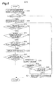
- Fig. 7 is a flowchart showing a process performed in the terminal location specifying system 7.
- the mobile terminal 1 activates the approximate position measurement unit 10 (S1).
- the mobile terminal 1 may activate the direction measurement unit 11 at the same time.
- the approximate position measurement unit 10 measures an approximate position where the mobile terminal 1 is located (S2, approximate position measurement step).
- the direction measurement unit 11 may measure the viewing direction in the landmark photographing unit 14.
- the approximate position information transmitting unit 12 transmits the approximate position information to the server 3 (S3, approximate position information transmitting step). Father, when the measurement of the viewing direction by the direction measurement unit 11 is performed, the approximate position information transmitting unit 12 may transmit the direction information together with the approximate position information to the server 3.
- the approximate position information receiving unit 30 receives the approximate position information transmitted from the mobile terminal 1 (S4, approximate position information receiving step). Note that, when the direction information transmitter together with the approximate position information from the approximate position information transmitting unit 12, the approximate position information receiving unit 30 receives the approximate position information and the direction information in Step S4.
- the landmark retrieval unit 32 retrieves landmark information from the landmark information storage unit 31 (S5, landmark retrieval step).
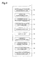
- the landmark retrieval process is described in detail with reference to Fig. 8.
- Fig. 8 is a flowchart sowing the landmark retrieval process.
- the landmark extraction unit 33 extracts landmark information of a landmark located within a pre-specified distance from the approximate position from the landmark information storage unit 31 based on the approximate position information of the mobile terminal 1 and information about the "position" in the landmark information storage unit 31 (S20).
- the process proceeds to Step S22.
- Step S31 S21.
- Step S22 the landmark retrieval unit 32 extracts a landmark at the shortest distance from the approximate position from the landmarks extracted by the landmark extraction unit 33 (S22).
- the mobile direction check unit 34 checks whether the landmark extracted in Step S22 is located in a specified angular range centering on the viewing direction of the mobile terminal 1 based on the direction information and the approximate position information from the mobile terminal 1 and information about the "position" in the landmark information storage unit 31 (S23). When it is determined that the landmark being checked is located in the specified angular range centering on the viewing direction of the mobile terminal 1, the process proceeds to Step S24. On the other hand, when it is not determined that the landmark being checked is located in the specified angular range centering on the viewing direction of the mobile terminal 1, the process proceeds to Step S28.
- Step S24 the visible angle check unit 35 checks whether the landmark extracted by the landmark extraction unit 33 in Step S22 is a landmark that is visible from the located position of the mobile terminal 1 based on the approximate position information and the "visible angle" in the landmark information storage unit 31 (S24). When it is determined that the landmark being checked is a landmark that is visible from the located position of the mobile terminal 1, the process proceeds to Step S25. On the other hand, when it is not determined that the landmark being checked is a landmark that is visible from the located, position of the mobile terminal 1, the process proceeds to Step S28.
- Step S25 the display size check unit 36 checks whether, the landmark extracted by the landmark extraction unit 33 is a landmark where, when a landmark photographed by the landmark photographing unit 14 of the mobile terminal 1 is displayed on a display unit (not shown) of the mobile terminal 1, the size of a region occupied by the image of the landmark with respect to the whole image on the display unit is within the range of a predetermined size (S25).
- the process proceeds to Step S26.
- the process proceeds to Step S28.
- Step S26 the shield retrieval unit 37 checks whether the landmark extracted by the landmark extraction unit 33 is a landmark with no shield between the approximate position of the mobile terminal 1 and the landmark based on the map data stored in the map data storage unit 42 and the approximate position information (S26).
- the landmark retrieval unit 32 sends the landmark information of the landmark to the landmark information transmitting unit 38, and the landmark retrieval process thereby ends (S27).
- the process proceeds to Step S28.
- Step S28 the landmark retrieval unit 32 retrieves a landmark whose distance from the approximate position is the second shortest to the landmark extracted in Step S22 among the landmarks extracted by the landmark extraction unit 33 (S28).
- Step S28 When one or more landmarks are extracted in Step S28, the process proceeds to Step S30 (S29). On the other hand, when one or more landmarks are not extracted in Step S28, the process proceeds to Step S31 (S29).
- Step S29 the landmark retrieval unit 32 determines whether the number of times of retrieving a landmark in Steps S22 and S28 reaches a specified number (N times). When the number of landmark retrievals has reached N times, the process proceeds to Step S31. On the other hand, when the number of landmark retrievals has not reached N times, the process proceeds to Step S23.
- Step S31 the landmark retrieval unit 32 notifies the mobile terminal 1 that there is no landmark information to be transmitted to the mobile terminal 1 through the landmark information transmitting unit 38.
- Step S5 in Fig. 7 the processing of Step S5 in Fig. 7 ends, the process of the terminal, location specifying method ends without performing the processing after Step S6.
- Step S6 the landmark information transmitting unit 38 transmits the landmark information retrieved by the landmark retrieval unit 32 to the mobile terminal 1 (S6, landmark information transmitting step).
- the landmark information receiving unit 13 receives the landmark information from the server 3 (S7, landmark information receiving step).
- the mobile terminal 1 activates the landmark photographing unit 14 (S8). Note that, although the landmark photographing unit 14 is activated in Step S8 in this embodiment, it may be activated at the point of time when the process of the terminal location specifying method shown in the flowchart of Fig. 7 is started or at some point before the process is started.
- a user who has recognized the located position or the like of the landmark based of the landmark information activates the landmark photographing unit 14, and the landmark photographing unit 14 photographs and acquires the image of the landmark (S9, landmark photographing step).
- the mobile terminal 1 may transmit a request for transmitting landmark information of another landmark that can be a candidate for photographing to the server 1.
- the landmark retrieval unit 32 of the server 1 extracts another landmark information by performing the processing of Steps 523 to S30 again.
- the landmark image transmitting unit 15 transmits the landmark image acquired from the landmark photographing unit 14 to the server 3 (S10, landmark image transmitting step).
- Step S11 the landmark image receiving unit 39 receives the landmark image transmitted from the mobile terminal 1 (S11, landmark image receiving step).
- the terminal position analysis unit 40 analyzes the position of the mobile terminal 1 at the time when the landmark image has been photographed based on the landmark image received by the landmark image receiving unit 39 in Step S11 (S12, terminal position analysis step).
- the terminal position information transmitting unit 41 transmits the position of the mobile terminal 1 analyzed by the terminal position analysis unit 40 as terminal position information to the mobile terminal (S13, terminal position information transmitting step).
- the position information receiving unit 16 receives the terminal position information analyzed tin the server 3 from the server 3 (S14, position information receiving step).
- the position information management unit 17 manages the position indicated by the terminal position information received by the position information receiving unit 16 as the located position of the mobile terminal 1 and uses the terminal position information for the correction of the position of its own terminal (S15, position information management Step). The process according to this embodiment thereby ends.
- Steps S23 to S27 as shown in Fig. 8 in the landmark retrieval process according to this embodiment, the processing of Steps S23, S24, S25 (S26, S27) may be performed in a different order.
- Step S23 the processing of Step S23 may be skipped. Specifically, the landmark retrieval unit 32 may refrain from using the direction information in the landmark retrieval process. In this case, the direction measurement unit 11 may be eliminated from the mobile terminal 1. Further, the mobile direction check unit 34 may be eliminated from the server 3.
- Steps S26 and S27 may be skipped. Specifically, the landmark retrieval unit 32 may refrain from determining the presence or absence of a shield in the landmark retrieval process. In this case, the shield retrieval unit 37 may be eliminated from the server 3.
- Step S24 the processing of Step S24 may be skipped. Specifically, the landmark retrieval unit 32 may refrain from considering the visible angle of a landmark in the landmark retrieval process. In this case, the visible angle check unit 35 may be eliminated from the server 3.
- Step S25 the processing of Step S25 may be skipped.
- the landmark retrieval unit 32 may retrain from considering the size of a landmark image on the mobile terminal 1 in the landmark retrieval process.
- the display size check unit 36 may be eliminated from the server 3.
- the approximate position information may contain measurement error information of the approximate position.
- the approximate position information transmitting unit 12 transmits the approximate position information containing the measurement error information to the server 3, and the server 3 that has received the measurement error information can change the condition for retrieving a landmark in the landmark retrieval unit 32 according to the degree of measurement errors. For example, when the error indicated by the measurement error information is larger than a predetermined specified value, the landmark retrieval unit 32 changes the "specified distance" at the time when extracting a landmark in the landmark extraction unit 33 to be a larger value.
- the position information management unit 17 may calculate an error between the terminal position information acquired in Step S15 and the approximate position information and notifies the calculated error information to the server 3.
- the server 3 that has received the error information can charge the condition for retrieving a landmark in the landmark retrieval unit 32 according to the degree of errors. For example, when the error indicated by the error information is larger than a predetermined first specified value and smaller then a second specified value, the landmark retrieval unit 32 changes the "specified distance" at the time when extracting a landmark in the landmark extraction unit 33 to be a smaller value in order to prevent extraction of a landmark that causes difficulties in photographing of the landmark and position analysis of the mobile terminal 1.
- the landmark retrieval unit 32 changes the "specified distance" at the time when extracting a landmark in the landmark extraction unit 33 to be a larger value in order to prevent that a landmark to be photographed is not found in the vicinity of the mobile terminal 1.
- the mobile terminal 1 and the terminal location specifying method according to the first embodiment described above based on approximate position information of the mobile terminal 1, landmark information of a landmark located within a specified distance from the approximate position is retrieved, and the retrieved landmark information is transmitted to the mobile terminal 1.
- the mobile terminal 1 can thereby acquire the landmark information related to the landmark located in the vicinity of the mobile terminal. Further, because the landmark information stored in advance in the server 3 is transmitted to the mobile terminal 1, it is possible to reliably specify the position of the mobile terminal 1 based can the landmark image.
- the photographing position of the image is analyzed based on the landmark image, and the photographing position is managed as the located position of the mobile terminal 1 in the mobile terminal 1 and used for the correction of the position, and it is thus possible to accurately specify the position of the mobile terminal, 1.
- Fig. 9 is a block diagram showing a functional configuration of a mobile terminal 1 according to a second embodiment.
- the mobile terminal 1 according to the second embodiment includes a landmark guide unit 18 (landmark guide means) and a display unit 19 (display means) in addition to the functional units 10 to 17 included in the mobile terminal 1 according to the first embodiment.
- the landmark guide unit 18 is a part that displays guide information that provides a guide to the position of a landmark on the display unit 19 included in the mobile terminal 1 based can a positional relationship between the approximate position of the mobile terminal 1 and the located position of the landmark indicated by landmark position information.
- the display unit 19 is a part that displays the guide information generated by the landmark guide unit.
- the landmark information contains landmark position information indicating the located position of the landmark and information about the height of a position where the landmark is located.
- the landmark guide unit 18 calculates the relative position of the landmark with respect to the approximate position of the mobile terminal 1, the direction in which the landmark is located, and the distance to the landmark as the guide information.
- the landmark guide unit 18 then displays the calculated guide information on the display unit 19.
- Fig. 10 is a diagram showing an example of the guide information displayed on the display unit 19.
- the display unit 19 displays guide information I 1 superimposed on an image of the real space captured by a camera included in the mobile terminal 1.
- the guide information I 1 indicates the distance to the position of the landmark "signboard XXX", the direction and height where the landmark "signboard XXX" is located, and the direction to rotate the mobile terminal 1 in order to photograph the landmark.
- the display unit 19 displays guide information I 2 superimposed on an image of the landmark "signboard XXX" captured at the front of the mobile terminal 1.
- the guide information I 2 indicates the distance to the position of the landmark "signboard XXX", the direction and height where the landmark "signboard XXX” is located, and the direction to rotate the mobile terminal 1 in order to photograph the landmark.
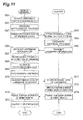
- Fig. 11 is a flowchart showing a process performed in the terminal location specifying system 7 according to the second embodiment.
- Step S67 the landmark guide unit 18 generates guide information based on a positional relationship between the approximate position of the mobile terminal 1 and the located position of the landmark indicated by landmark position information and displays the generated guide information on the display unit 19. By displaying the guide information, a user of the mobile terminal 1 can easily recognize the located position of the landmark.
- Steps S68 to S75 is the same as the processing of Steps S8 to S15 in the first embodiment ( Fig . 7 ), respectively.
- location specifying system 7 because the located position of a landmark is guided to a user through the display unit 19 of the mobile terminal 1, the user can reliably recognize the position of the landmark. Accordingly, the photographing and acquisition of the landmark image can be performed easily. Further, because information related to the height of the location of a landmark is also guided to a user through the display unit 19 of the mobile terminal 1, the user can more reliably recognize the position of the landmark. The photographing and acquisition of the landmark image can be thereby performed reliably.
- a third embodiment is different from the first embodiment in that the analysis of the position of the mobile terminal 1 when a landmark image has been photographed is performed not in the server 3 but in the mobile terminal 1.
- Fig. 12 is a block diagram showing the functional configuration of the mobile terminal 1 according to the third embodiment.
- the mobile terminal, 1 according to the third embodiment includes a photographing position analysis unit 20 (photographing position analysis means) in addiction to the functional units 10, 12 to 14 and 17 included in the mobile terminal 1 according to the first embodiment.
- the photographing position analysis unit 20 is a part that analyzers the position of the mobile terminal 1 when a landmark image has been photographed based on the landmark image photographed by the landmark photographing unit 14. Specifically, the photographing position analysis unit 20 analyzes the position of the mobile terminal 1 when a landmark image has been photographed based on a difference between information about the position, size and shape of a landmark in the real spaced contained in the landmark information received by the landmark information receiving unit and the position, size and shape of a landmark in the landmark image.
- Fig. is is a flowchart showing a process performed in the terminal location specifying system 7 according to the third embodiment.
- Steps S80 to S88 is the same as the processing of Steps S 1 to S9 in the first embodiment ( Fig. 7 ), respectively.
- Step S89 the photographing position analysis unit 20 analyzes the position of the mobile terminal 1 when a landmark image has been photographed based can the landmark image photographed by the landmark photographing unit 14 (S89, photographing position analysis step).
- the position information management unit 17 managers the position indicated by the terminal position information analyzed by the photographing position analysis unit 20 as the located position of the mobile terminal 1 and uses the terminal position information for the correction of the position of its own terminal (S90, position information management step). The process according to this embodiment thereby ends.
- the mobile terminal, 1 and the terminal location specifying method according to the third embodiment described above based on approximate position information of the mobile terminal 1, landmark information of a landmark located within a specified distance from the approximate position is retrieved, and the retrieved landmark information is transmitted to the mobile terminal 1.
- the mobile terminal 1 can thereby acquire the landmark information related to the landmark located in the vicinity of the mobile terminal 1. Further, because the landmark information stored in advance in the server 3 is transmitted to the mobile terminal 1, it is possible to reliably specify the position of the mobile terminal 1 based on the landmark image. Then, in the mobile terminal 1, the photographing position of the image is analyzed based on the landmark image, and the photographing position is managed as the located position of the mobile terminal 1, and it is thus possible to accurately and easily specify the position of the mobile terminal 1.
- shield retrieval unit 38...landmark information transmitting unit, 39...landmark image receiving unit, 40...terminal position analysis unit, 41...terminal, position information transmitting unit, 42...map data storage unit, C A ...shield, I 1 ,I 2 ...guide information, L A ,L B ,L C ... landmark, P...user
Abstract
Description
- The present invention relates to a terminal location specifying system, a mobile terminal, and a terminal location specifying method.
- In recent years, a service using AR (Augmented Reality) technology has been developed and provided. For example, a technique that acquires an object placed in the vicinity of the located position of a mobile terminal and displays an object including various information and images superimposed on an image acquired by a camera included in the mobile terminal is known. In this technique, an object to be superimposed is selected based on the located position of the mobile terminal. Further, the mobile terminal displays an object based on a positional relationship between the located position of the terminal itself and the position of the object. It is thus important in this technique to accurately detect the located position of the mobile terminal. For example, a technique that acquires the position of an arbitrary landmark object captured by a camera included in a terminal device from a database that pre-stores the positional information of landmark objects and calculates the position of the terminal device based on the acquired position of the landmark object is known (for example, see Patent Literature 1).
-
- PTL 1: Japanese Unexamined Patent Application Publication No.
2001-235534 - However, in the related art, the position of the terminal device cannot be specified unless information about a landmark object photographed by the terminal device does not exist in the database. Further, the volume of a database becomes enormous if the database stores information about all structures that can be a landmark object in order to specify the position of the terminal device based on a landmark object that is randomly photographed.
- The present invention has been accomplished to solve the above problems and an object of the present invention is thus to provide a terminal location specifying system, a mobile terminal, and a terminal location specifying method that can accurately and reliably specify the position of the mobile terminal in the AR technology.
- To solve the above problem, a terminal location specifying system according to one embodiment of the present invention is a terminal location specifying system for specifying a position of a mobile terminal, the system including the mobile terminal and a server capable of communicating with the mobile terminal, the mobile terminal including an approximate position measurement means for measuring an approximate position where the mobile terminal is located, an approximate position information transmitting means for transmitting approximate position information about the approximate position measured by the approximate position measurement means to the server, a landmark information receiving means for receiving landmark information about a landmark from the server, the landmark being a photographing object to be photographed by the mobile terminal for specifying the position of the mobile terminal, a landmark photographing means for photographing the landmark indicated by the landmark information received by the landmark information, receiving means, a landmark image transmitting means for transmitting a landmark image being an image of the landmark photographed by the landmark photographing means to the server, a position information receiving means for receiving terminal position information indicating a position of the mobile terminal when the landmark image has been photographed from the server, and a position information management means for managing a position indicated by the terminal position information received by the position information receiving means as a located position of the mobile terminal, and the server including an approximate position information receiving means for receiving the approximate position information transmitted from the mobile terminal, a landmark information storage means for storing a plurality of landmark information, a landmark retrieval means for retrieving the landmark information of the landmark located within a pre-specified distance from the approximate position from the landmark information storage means based on the approximate position information received by the approximate position information receiving means, a landmark information transmitting means for transmitting the landmark information retrieved by the landmark retrieval means to the mobile terminal, a landmark image receiving means for receiving the landmark image transmitted from the mobile terminal, a terminal position analysis means for analysing the position of the mobile terminal when the landmark image has been photographed based on the landmark image received by the landmark image receiving means, and a terminal position information transmitting means for transmitting the position of the mobile terminal analyzed by the terminal position analysis means as terminal position information to the mobile terminal.
- To solve the above problem, a mobile terminal according to one embodiment of the present invention is a mobile terminal in a terminal location specifying system for specifying a position of a mobile terminal, the system including the mobile terminal and a server capable of communicating with the mobile terminal, the mobile terminal including an approximate position measurement means for measuring an approximate position where the mobile terminal is located, an approximate position information transmitting means for transmitting approximate position information about the approximate position measured by the approximate position measurement means to the server, a landmark information receiving means for receiving landmark information about a landmark from the server, the landmark being a photographing object to be photographed by the mobile terminal for specifying the position of the mobile terminal, a landmark photographing means for photographing the landmark indicated by the landmark information received by the landmark information receiving means, a landmark image transmitting means for transmitting a landmark image being an image of the landmark photographed by the landmark photographing means to the server, a position information receiving means for receiving terminal position information indicating a position of the mobile terminal when the landmark image has been photographed from the server, and a position information management means for managing a position indicated by the terminal position information received by the position information receiving means as a located position of the mobile terminal.
- Further, to solve the above problem, a terminal location specifying method according to one embodiment of the present invention is a terminal location specifying method in a terminal location specifying system for specifying a position of a mobile terminal, the system including the mobile terminal and a server capable of communicating with the mobile terminal, the method including an approximate position measurement step of measuring an approximate position where the mobile terminal is located by the mobile terminal, an approximate position information transmitting step of transmitting approximate position information about the approximate position measured in the approximate position measurement step from the mobile terminal to the server, an approximate position information receiving step of receiving the approximate position information transmitted in the approximate position information transmitting step by the server, a landmark retrieval step of retrieving the landmark information of the landmark located within a pre-specified distance from the approximate position by the server based on the approximate position information received in the approximate position information receiving step by referring to a landmark information storage means storing a plurality of landmark information about a landmark being a photographing object to be photographed by the mobile terminal for specifying the position of the mobile terminal, a landmark information transmitting step of transmitting the landmark information retrieved in the landmark retrieval step from the server to the mobile terminal, a landmark information receiving step of receiving the landmark information from the server by the mobile terminal, a landmark photographing step of photographing the landmark indicated by the landmark information received in the landmark information receiving step by the mobile terminal, a landmark image transmitting step of transmitting a landmark image being an image of the landmark photographed in the landmark photographing step from the mobile terminal to the server, a landmark image receiving step of receiving the landmark image transmitted in the landmark image transmitting step by the server, a terminal position analysis step of analyzing the position of the mobile terminal when the landmark image has been photographed based on the landmark image received in the landmark image receiving step by the server, a terminal position information transmitting step of transmitting the position of the mobile terminal analyzed in the terminal position analysis step as terminal position information from the server to the mobile terminal, a position information receiving step of receiving the terminal position information transmitted in the terminal position information transmitting step by the mobile terminal, and a position information management step of managing a position indicated by the terminal position information received in the position information receiving step as a located position of the mobile terminal by the mobile terminal.
- According to the terminal location specifying system, the mobile terminal and the terminal location specifying method, landmark information of a landmark located within a specified distance from an approximate position is retrieved based on approximate position information of the mobile terminal, and the retrieved landmark information is transmitted to the mobile terminal. The mobile terminal can thereby acquire the landmark information about the landmark located in the vicinity of the mobile terminal. Further, because the landmark information pre-stored in the server is transmitted to the mobile terminal, it is possible to reliably specify the position of the mobile terminal based on the landmark image. Then, the photographing position of the image is analyzed based on the landmark image, and the photographing position is managed as the located position of the mobile terminal in the mobile terminal, and it is thus possible to accurately specify the position of the mobile terminal.
- Further, in the terminal location specifying system according to one embodiment of the present invention, the mobile terminal may further include a direction measurement means for measuring a viewing direction being a direction of sight in the landmark photographing means, and the approximate position information transmitting means may transmit information about the viewing direction measured by the direction measurement means as direction information, together with the approximate position information, to the server, and the landmark retrieval means may retrieve the landmark information of the landmark located within a pre-specified distance from the approximate position indicated by the approximate position information and located in a specified angular range centering on the viewing direction indicated by the direction information from the landmark information storage means.
- In this case, the viewing direction in the landmark photographing means of the mobile terminal is transmitted to the server, the landmark information of the landmark located in the specified angular range centering on the viewing direction is extracted and transmitted to the mobile terminal. The landmark information of the landmark that can be photographed in the mobile terminal is thereby transmitted from the server to the mobile terminal. Thus, the landmark image can be reliably acquired, and it is possible to reliably specify the position of the mobile terminal.
- Further, in the terminal location specifying system according to one embodiment of the present invention, the server may further include a map data storage means for storming map data, and the landmark retrieval means may refer to the map data storage means and retrieve the landmark information of the landmark located within a pre-specified distance from the approximate position indicated by the approximate position information and where a shield does not exist between the approximate position and the landmark from the landmark information storage means.
- In this case, the landmark information of the landmark having no shield between the located position of the mobile terminal, and the landmark is extracted based on the map data and transmitted to the mobile terminal. The landmark information of the landmark that can be photographed in the mobile terminal is thereby transmitted from the server to the mobile terminal. Thus, the landmark image can be reliably acquired, and it is possible to reliably specify the position of the mobile terminal.
- Further in the terminal location specifying system according to one embodiment of the present invention, the landmark information may contain a visible angle being information indicating an angular range with respect to a facing direction of the landmark where the landmark is visible, and when the approximate position is located within the angular range indicated by the visible angle of the landmark, the landmark retrieval means may retrieve the landmark information of the landmark from the landmark information storage means.
- In this case, the landmark information of the landmark that is visible from the mobile terminal is transmitted from the server to the mobile terminal. Thus, the landmark image can be reliably acquired, and it is possible to reliably specify the position of the mobile terminal.
- Further, in the terminal location specifying system according to one embodiment of the present invention, the landmark retrieval means may retrieve the landmark information of the landmark where, when the landmark is photographed by the landmark photographing means, a legion size of an image of the landmark with respect to a whole photographed image is within a range of a prescribed size from the landmark information storage means.
- In this case, the landmark information of the landmark that is displayed in an appropriate size on the mobile terminal is transmitted from the server to the mobile terminal. Thus, the photographing of the landmark in the mobile terminal and the analysis of the position of the mobile terminal based on the landmark image become easy.
- Further, in the terminal location specifying system according to one embodiment of the present invention, the landmark information may contain landmark position information indicating a located position of the landmark, and the mobile terminal, may further include a landmark guide means for displaying guide information providing a guide to the position of the landmark on a display means included in the mobile terminal based on a positional relationship between the approximate position of the mobile terminal and the located position of the landmark indicated by the landmark position information.
- In this case, the located position of the landmark is guided to a user through the display means of the mobile terminal, and the user can reliably recognize the position of the landmark. Accordingly, the photographing and acquisition of the landmark image can be performed easily.
- Further, in the terminal location specifying system according to one embodiment of the present invention, the landmark information may contain information about a height of a position where the landmark is located, and the landmark guide means may display the position and height of the landmark as the guide information on the display means.
- In this case, information about the height where the landmark is located is also guided to a user through the display means of the mobile terminal, and the user can more reliably recognize the position of the landmark. Accordingly, the photographing and acquisition of the landmark image are reliably performed.
- Further, in the terminal location specifying system according to one embodiment of the present invention, the terminal position analysis means may analyze the position of the mobile terminal when the landmark image has been photographed based on a difference between a position, size and shape of the landmark in a real space and a position, size and shape of the landmark in the landmark image. It is thereby possible to analyze the position of the mobile terminal with high accuracy.
- To solve the above problem, a terminal location specifying system according to one embodiment of the present invention is a terminal location specifying system for specifying a position of a mobile terminal, the system including the mobile terminal and a server capable of communicating with the mobile terminal, the mobile terminal including an approximate position measurement means for measuring an approximate position where the mobile terminal is located, an approximate position information transmitting means for transmitting approximate position information about the approximate position measured by the approximate position measurement means to the server, a landmark information receiving means for receiving landmark information about a landmark from the server, the landmark being a photographing object to be photographed by the mobile terminal for specifying the position of the mobile terminal, a landmark photographing means for photographing the landmark indicated by the landmark information received by the landmark information receiving means, a photographing position analysis means for analyzing a located position of the mobile terminal when a landmark image has been photographed based on the landmark image being an image of the landmark photographed by the landmark photographing means, a position information management means for managing information about the located position of the mobile terminal analyzed by the photographing position analysis means, and the server including an approximate position information receiving means for receiving the approximate position information transmitted from the mobile terminal, a landmark information storage means for storing a plurality of landmark information, a landmark retrieval means for retrieving the landmark information of the landmark located within a pre-specified distance from the approximate position from the landmark information storage means based on the approximate position information received by the approximate position information receiving means, and a landmark information transmitting means for transmitting the landmark information retrieved by the landmark retrieval means to the mobile terminal.
- To solve the above problem, a mobile terminal according to one embodiment of the present invention is a mobile terminal in a terminal, location specifying system for specifying a position of a mobile terminal, the system including the mobile terminal and a server capable of communicating with the mobile terminal, the mobile terminal including an approximate position measurement means for measuring an approximate position where the mobile terminal is located, an approximate position information transmitting means for transmitting approximate position information about the approximate position measured by the approximate position measurement means to the server, a landmark information receiving means for receiving landmark information about a landmark from the server, the landmark being a photographing object to be photographed by the mobile terminal for specifying the position of the mobile terminal, a landmark photographing means for photographing the landmark indicated by the landmark information received by the landmark information receiving means, a photographing position analysis means for analysing a located position of the mobile terminal when a landmark image has been photographed based on the landmark image being an image of the landmark photographed by the landmark photographing means, a position information management means for managing information about the located position of the mobile terminal analyzed by the photographing position analysis means.
- Further, to solve the above problem, a terminal location specifying method according to one embodiment of the present invention is a terminal location specifying method in a terminal location specifying system for specifying a position of a mobile terminal, the system including the mobile terminal and a server capable of communicating with the mobile terminal, the method including an approximate position measurement step of measuring an approximate position where the mobile terminal is located by the mobile terminal, an approximate position information transmitting step of transmitting approximate position information about the approximate position measured in the approximate position measurement step from the mobile terminal to the server an approximate position information receiving step of receiving the approximate position information transmitted in the approximate position information transmitting step by the server, a landmark retrieval step of retrieving the landmark information of the landmark located within a pre-specified distance from the approximate position by the server based on the approximate position information received in the approximate position information receiving step by referring to a landmark information storage means storing a plurality of landmark information about a landmark being a photographing object to be photographed by the mobile terminal for specifying the position of the mobile terminal, a landmark formation transmitting step of transmitting the landmark information retrieved in the landmark retrieval step from the server to the mobile terminal, a landmark information receiving step of receiving the landmark information from the server by the mobile terminal, a landmark photographing step of photographing the landmark indicated by the landmark information received in the landmark information receiving step by the mobile terminal, a photographing position analysis step of analyzing a located position of the mobile terminal when a landmark image has been photographed by the mobile terminal based on the landmark image being an image of the landmark photographed in the landmark photographing step, and a position information management step of managing information about the located position of the mobile terminal analyzed in the photographing position analysis step by the mobile terminal.
- According to the terminal location specifying system, the mobile terminal and the terminal location specifying method, landmark information of a landmark located within a specified distance from an approximate position is retrieved based on approximate position information of the mobile terminal, and the retrieved landmark information is transmitted to the mobile terminal. The mobile terminal can thereby acquire the landmark information about the landmark located in the vicinity of the mobile terminal. Further, because the landmark information pre-stored in the server is transmitted to the mobile terminal, it is possible to reliably specify the position of the mobile terminal based on the landmark image. Then, the photographing position of the image is analyzed based on the landmark image, and the photographing position is managed as the located position of the mobile terminal in the mobile terminal, and it is thus possible to accurately and easily specify the position of the mobile terminal.
- It is possible to accurately and reliably specify the position of the mobile terminal in the AR technology.
-
-
Fig. 1 is a diagram showing a device configuration of a terminal location specifying system. -
Fig. 2 is a block diagram showing a functional configuration of a mobile terminal according to a first embodiment. -
Fig. 3 is a hardware block diagram of a mobile terminal. -
Fig. 4 is a block diagram showing a functional configuration of a server according to the first embodiment. -
Fig. 5 is a diagram showing a configuration of a landmark information storage unit and an example of data stored therein. -
Fig. 6 is a diagram showing a positional relationship between a user having a mobile terminal and a landmark. -
Fig. 7 is a timing chart showing a process of a terminal location specifying method according to the first embodiment. -
Fig. 8 is a flowchart showing a landmark retrieval process inFig. 7 . -
Fig. 9 is a block diagram showing a functional configuration of a mobile terminal according to a second embodiment. -
Fig. 10 is a diagram showing an example of guide information displayed on adisplay unit 19. -
Fig. 11 is a timing chart showing a process of a terminal location specifying method according to the second embodiment. -
Fig. 12 is a block diagram showing a functional configuration of a mobile terminal according to a third embodiment. -
Fig. 13 is a timing chart showing a process of a terminal location specifying method according to the third embodiment. - Embodiments of a terminal location specifying system, a mobile terminal, and a terminal location specifying method according to the present invention are described hereinafter with reference to the drawings. Note that, where possible, the same elements are denoted by the same reference numerals and redundant description thereof is omitted.
-
Fig. 1 is a diagram showing a device configuration of a terminallocation specifying system 7 according to a first embodiment. As shown inFig. 1 , the terminallocation specifying system 7 includes a mobile terminal and aserver 3 that can communicate with themobile terminal 1. Themobile terminal 1 is a portable terminal that can perform communication through a mobile communication network, for example. Thus, themobile terminal 1 communicates with the server through abase station 5, which is a mobile communication network. -
Fig. 2 is a block diagram shewing a functional configuration of themobile terminal 1 according to the first embodiment. Themobile terminal 1 according to this embodiment is a device that controls display of an object placed in the real space or the virtual space, for example, and has a function of acquiring an object placed in the vicinity of the located position of themobile terminal 1 in the real space or the virtual space from the server and displaying an object including various information and images superimposed on an image in the real space acquired by a camera included in themobile terminal 1. In order to accurately control the display position of an object on a display means such as a display of themobile terminal 1, it is necessary to accurately detect the located position of themobile terminal 1 in this embodiment. - As shown in
Fig. 2 , themobile terminal 1 includes, as functional components, an approximate position measurement unit 10 (approximate position measurement means), a direction measurement unit 11 (direction measurement means), an approximate position information transmitting unit 12 (approximate position information transmitting means), a landmark information receiving unit 13 (landmark information receiving means), a landmark photographing unit 14 (landmark photographing means), a landmark image transmitting unit 15 (landmark image transmitting means), a position information receiving unit 16 (position information receiving means), and a position information management unit 17 (position information management means). -
Fig. 3 is a hardware block diagram of themobile terminal 1. As shown inFig. 3 , themobile terminal 1 is physically configured as a computer system that includes aCPU 101, aRAM 102 and aROM 103 which are a main storage device, acommunication module 104 which is a data transmitting and receiving device, amauxiliary storage device 105 such as a hard disk or flash memory, aninput device 106 such as a keyboard, anoutput device 107 such as a display and the like. The functions shown inFig. 2 are implemented by loading given computer software onto hardware such as theCPU 101 or theRAM 102 shown inFig. 3 , making thecommunication module 104, theinput device 106 and theoutput device 107 operate under control of theCPU 101, and performing reading and writing of data in theRAM 102 or theauxiliary storage device 105. The respective functional units of the terminal,location specifying system 7 are described hereinafter in detail with preference back toFig. 2 . - The approximate
position measurement unit 10 is a part that measures an approximate position where themobile terminal 1 is located. The approximateposition measurement unit 10 may be a GPS device, for example. The position measurement by the GPS contains errors caused by the principle of measurement. Accordingly, a position measured by the approximateposition measurement unit 10 is an approximate position. The approximateposition measurement unit 10 sends approximate position information about the approximate position to the approximate positioninformation transmitting unit 12. - The
direction measurement unit 11 is a part that measures a viewing direction, which is the line oaf sight in thelandmark photographing unit 14. Thedirection measurement unit 11 sends information about the measured viewing direction as direction information to the approximate positioninformation transmitting unit 12. - The approximate position
information transmitting unit 12 is a part that transmits the approximate position information about the approximate position measured by the approximateposition measurement unit 10 to theserver 3. Further, when the measurement of the viewing direction by thedirection measurement unit 11 has been performed, the approximate positioninformation transmitting unit 12 transmits the direction information, together with the approximate position information, to theserver 3. - The landmark
information receiving unit 13 is a part that receives landmark information about a landmark from the server. The landmark is a photographing object that exists in the real space and is to be photographed by the mobile terminal, 1 for specifying the position of themobile terminal 1. For example, the landmark is a structure such as a specified building or signboard. Further, the landmark information contains information about the located position of a landmark and object information for recognizing the outer appearance of a landmark. The landmark information is described in detail later. - The
landmark photographing unit 14 is a part that photographs a landmark indicated by the landmark information, and it may be a camera, for example. Because a user of the mobile terminal, 1 can recognize the located position or the like of a landmark based on the landmark information, the user can photograph the landmark by activating thelandmark photographing unit 14. Thelandmark photographing unit 14 sends the image of the photographed landmark to the landmarkimage transmitting unit 15. - The landmark
image transmitting unit 15 is a part that transmits the landmark image acquired from thelandmark photographing unit 14 toserver 3. - The position
information receiving unit 16 is a part that receives terminal position information analyzed by theserver 3 from theserver 3. The terminal position information is information indicating the position of the mobile terminal when the landmark image has been photographed. The analysis of the terminal position information is described later. - The position
information management unit 17 is a part that managers a position indicated by the terminal position information received by the positioninformation receiving unit 16 as the located position of themobile terminal 1. Specifically, the positioninformation management unit 17 uses a position indicated by the terminal position information as a reference position when displaying an object placed in the real space or the virtual space superimposed on an image of the real space acquired by the camera. Themobile terminal 1 acquires an object placed in the vicinity of themobile terminal 1 tin the real space or the virtual space using a position indicated by the terminal position information as a reference position and displays the object based on a positional relationship between the reference position of themobile terminal 1 and the position of the object. - The functions of the
server 3 are described if detail hereinafter.Fig. 4 is a block diagram showing a functional configuration or theserver 3 according to the first embodiment. Theserver 3 according to this embodiment includes an approximate position information receiving unit 30 (approximate position information receiving means), a landmark information storage unlit 3 (landmark information storage means), a landmark retrieval unit 32 (landmark retrieval means), a landmark information transmitting unit 38 (landmark information transmitting means), a landmark image receiving unit 39 (landmark image receiving means), a terminal position analysis unit 40 (terminal position analysis means), a terminal position information transmitting unit 41 (terminal, position information transmitting means), and a map data storage unit 42 (map data storage means). Theserver 3 is a computer having a hardware configuration similar to the hardware configuration of themobile terminal 1 shown inFig. 3 . The respective functional units of theserver 3 are described in detail with reference toFig. 4 . - The approximate position
information receiving unit 30 is a part that receives the approximate position information transmitted from themobile terminal 1. Further, when the direction information is transmitted together with the approximate position information from the approximate positioninformation transmitting unit 12, the approximate positioninformation receiving unit 30 receives the approximate position information and, the direction information. The approximate positioninformation receiving unit 30 sends the received approximate position information and direction information to thelandmark retrieval unit 32. - The landmark
information storage unit 31 is a part that stores landmark information.Fig. 5 is a diagram showing the configuration of the landmarkinformation storage unit 31 and an example of data stored therein. As shown inFig. 5 , the landmarkinformation storage unit 31 stores, as landmark information, information about a position, name, object information, height information, direction, visible angle, and size in association with each item number. - The "position" is information indicating the two-dimensional located position of a landmark. The "none" is information indicating the name of the landmark. The "object information" is two-dimensional or three-dimensional data that visually represents the shape of the landmark. The "height information" is information indicating the height of a position where the landmark is located. The "direction" is information about an angle indicating the direction which the landmark directly faces, and it increases as rotating clockwise, starting from the north as 0 degree. The "visible angle" is information indicating the angular range where the landmark is visible. The "horizontal" angular range in the visible angle is set with respect to the direction which the landmark directly faces. Further, the "vertical" angular range in the visible angle is set with respect to the horizontal direction. The "size" is information indicating the size of the outer shape of the landmark.
- The
landmark retrieval unit 32 is a part that retrieves landmark information of a landmark as a photographing object suitable for specifying the position of themobile terminal 1 from the landmarkinformation storage unit 31. Thelandmark retrieval unit 32 includes alandmark extraction unit 33, a mobiledirection check unit 34, a visibleangle check unit 35, a displaysize check unit 36, and ashield retrieval unit 37, as shown inFig. 4 . - The
landmark extraction unit 33 is a part that extracts landmark information of a landmark located within a pre-specified distance from the approximate position from the landmarkinformation storage unit 31 based on the approximate position information of themobile terminal 1 and information about the "position" in the landmarkinformation storage unit 31. - The mobile
direction check unit 34 is a part that checks whether the landmark extracted by thelandmark extraction unit 33 is located in the specified angular range centering can the viewing direction of themobile terminal 1 based on the direction information and the approximate position information from themobile terminal 1 and information about the "position" in the landmarkinformation storage unit 31. - The visible
angle check unit 35 is a part that checks whether the landmark extracted by thelandmark extraction unit 33 is a landmark that is visible from the located position of themobile terminal 1 based on the approximate position information and the "visible angle" in the landmarkinformation storage unit 31.Fig. 6 is a diagram showing a positional relationship between a user P having themobile terminal 1 and a landmark. Because the user P has the mobile terminal is the located position of the user P is substantially equal to the approximate position of themobile terminal 1. InFig. 6 , although the located position of the user P is included in the visible angle of the landmark Lc, it is not included in the visible angle of the landmark LB. Thus, the visibleangle check unit 35 determines the landmark LC as a landmark visible from the located position of themobile terminal 1 and determines the landmark LB as a landmark not visible from the located position of themobile terminal 1. - The display
size check unit 36 is a part that checks whether, the landmark extracted by thelandmark extraction unit 33 is a landmark where, when a landmark photographed by thelandmark photographing unit 14 of themobile terminal 1 is displayed can a display unit (not shown) of themobile terminal 1, the size of a region occupied by the image of the landmark with respect to the whole image on the display unit is within the range of a predetermined size. The size of a region occupied by the image of the landmark on the display unit depends on the distance between themobile terminal 1 and the landmark and the magnification when thelandmark photographing unit 14 captures the landmark. The landmark image for specifying the position of themobile terminal 1 is preferably displayed in an appropriate size on the display unit. Thus, the landmark information of a landmark suitable for photographing is extracted by the displaysize check unit 36. - The
shield retrieval unit 37 is a part that checks whether the landmark extracted by thelandmark extraction unit 33 is a landmark with no shield between the approximate position of themobile terminal 1 and the landmark based on the map data stored in the mapdata storage unit 42 and the approximate position information. Referring toFig. 6 , although a shield does not exist between the landmark LC and the user P, a shield CA exists between the landmark LA and the user P. Thus, theshield retrieval unit 37 determines the landmark LC as a landmark with no shield between the approximate position of themobile terminal 1 and the landmark, and determines the landmark LA as a landmark with a shield between the approximate position or the mobile terminal, 1 and the landmark. - In the case where the checking and extraction of the landmark information by the display
size check unit 36 and the visibleangle check unit 35 are performed, themobile terminal 1 may transmit photographing information related to a photograph viewing angle, focal length, magnification and the like when thelandmark photographing unit 14 captures the image of a landmark to theserver 3. In this case, thelandmark retrieval unit 32 acquires the photographing information transmitted from themobile terminal 1. Then, thelandmark retrieval unit 32 can chance thresholds related to the "visible angle" used for checking by the visibleangle check unit 35 and the display size used for checking by the displaysize check unit 36 in accordance with the photographing information. Note that the photographing information may be stored in advance in theserver 3. - The
landmark retrieval unit 32 sends the landmark information extracted by the functional unites 33 to 37 to the landmarkinformation transmitting unit 38. Note that, although thelandmark retrieval unit 32 according to this embodiment performs the checking and extraction of the landmark information using thelandmark extraction unit 33, the mobiledirection check unit 34, the visibleangle check unit 35, the displaysize check unit 36 and theshield retrieval unit 37 in this order, the order is not particularly limited. - The landmark
information transmitting unit 38 is a part that transmits the landmark information retrieved by thelandmark retrieval unit 32 to themobile terminal 1. - The landmark
image receiving unit 39 is a part that receives the landmark image transmitted from themobile terminal 1. - The terminal
position analysis unit 40 is a part that analyzes and calculates the position of themobile terminal 1 at the time when the landmark image has been photographed based on the landmark image received by the landmarkimage receiving unit 39. Specifically, the terminalposition analysis unit 40 analyzes the position of themobile terminal 1 at the time when the landmark image has been photographed based on a difference between the position, size and shape of the landmark in the real space extracted from the landmarkinformation storage unit 31 and the position, size and shape of the landmark in the landmark image. - The terminal, position information transmitting unit 4 is a part that transmits the position of the
mobile terminal 1 analyzes by the terminalposition analysis unit 40 as terminal position information to the mobile terminal. - The map
data storage unit 42 is a part that stores map data. The map data contains road shapes, geographic features, positions and shapes of structures such as buildings in the real space. - The operation of the terminal
location specifying system 7 in a terminal location specifying method according to this embodiment is described hereinafter with reference toFig. 7. Fig. 7 is a flowchart showing a process performed in the terminallocation specifying system 7. - First, the
mobile terminal 1 activates the approximate position measurement unit 10 (S1). Note that themobile terminal 1 may activate thedirection measurement unit 11 at the same time. Next, the approximateposition measurement unit 10 measures an approximate position where themobile terminal 1 is located (S2, approximate position measurement step). Note that, in Step S2, thedirection measurement unit 11 may measure the viewing direction in thelandmark photographing unit 14. Then, the approximate positioninformation transmitting unit 12 transmits the approximate position information to the server 3 (S3, approximate position information transmitting step). Father, when the measurement of the viewing direction by thedirection measurement unit 11 is performed, the approximate positioninformation transmitting unit 12 may transmit the direction information together with the approximate position information to theserver 3. - When the approximate position information or the like is transmitted from the
mobile terminal 1, the approximate positioninformation receiving unit 30 receives the approximate position information transmitted from the mobile terminal 1 (S4, approximate position information receiving step). Note that, when the direction information transmitter together with the approximate position information from the approximate positioninformation transmitting unit 12, the approximate positioninformation receiving unit 30 receives the approximate position information and the direction information in Step S4. - Next, the
landmark retrieval unit 32 retrieves landmark information from the landmark information storage unit 31 (S5, landmark retrieval step). The landmark retrieval process is described in detail with reference toFig. 8. Fig. 8 is a flowchart sowing the landmark retrieval process. - First, the
landmark extraction unit 33 extracts landmark information of a landmark located within a pre-specified distance from the approximate position from the landmarkinformation storage unit 31 based on the approximate position information of themobile terminal 1 and information about the "position" in the landmark information storage unit 31 (S20). When one or more landmarks are extracted in Step S20, the process proceeds to Step S22. On the other hand, when a landmark does not exist within a pre-specified distance from the approximate position in Step S20, the process proceeds to Step S31 (S21). - In Step S22, the
landmark retrieval unit 32 extracts a landmark at the shortest distance from the approximate position from the landmarks extracted by the landmark extraction unit 33 (S22). - Then, the mobile
direction check unit 34 checks whether the landmark extracted in Step S22 is located in a specified angular range centering on the viewing direction of themobile terminal 1 based on the direction information and the approximate position information from themobile terminal 1 and information about the "position" in the landmark information storage unit 31 (S23). When it is determined that the landmark being checked is located in the specified angular range centering on the viewing direction of themobile terminal 1, the process proceeds to Step S24. On the other hand, when it is not determined that the landmark being checked is located in the specified angular range centering on the viewing direction of themobile terminal 1, the process proceeds to Step S28. - In Step S24, the visible
angle check unit 35 checks whether the landmark extracted by thelandmark extraction unit 33 in Step S22 is a landmark that is visible from the located position of themobile terminal 1 based on the approximate position information and the "visible angle" in the landmark information storage unit 31 (S24). When it is determined that the landmark being checked is a landmark that is visible from the located position of themobile terminal 1, the process proceeds to Step S25. On the other hand, when it is not determined that the landmark being checked is a landmark that is visible from the located, position of themobile terminal 1, the process proceeds to Step S28. - In Step S25, the display
size check unit 36 checks whether, the landmark extracted by thelandmark extraction unit 33 is a landmark where, when a landmark photographed by thelandmark photographing unit 14 of themobile terminal 1 is displayed on a display unit (not shown) of themobile terminal 1, the size of a region occupied by the image of the landmark with respect to the whole image on the display unit is within the range of a predetermined size (S25). When it is determined that the landmark being checked is a landmark that is displayed within the range of a specified size when displayed on themobile terminal 1, the process proceeds to Step S26. On the other hand, when it is not determined that the landmark being checked is a landmark that is displayed within the range of a specified size when displayed on themobile terminal 1, the process proceeds to Step S28. - In Step S26, the
shield retrieval unit 37 checks whether the landmark extracted by thelandmark extraction unit 33 is a landmark with no shield between the approximate position of themobile terminal 1 and the landmark based on the map data stored in the mapdata storage unit 42 and the approximate position information (S26). When it is determined that the landmark being checked is a landmark with no shield between the approximate position of themobile terminal 1 and the landmark, thelandmark retrieval unit 32 sends the landmark information of the landmark to the landmarkinformation transmitting unit 38, and the landmark retrieval process thereby ends (S27). On the other hand, when it is not determined that the landmark being checked is a landmark with no shield between the approximate position of themobile terminal 1 and the landmark, the process proceeds to Step S28. - In Step S28, the
landmark retrieval unit 32 retrieves a landmark whose distance from the approximate position is the second shortest to the landmark extracted in Step S22 among the landmarks extracted by the landmark extraction unit 33 (S28). - When one or more landmarks are extracted in Step S28, the process proceeds to Step S30 (S29). On the other hand, when one or more landmarks are not extracted in Step S28, the process proceeds to Step S31 (S29).
- In Step S29, the
landmark retrieval unit 32 determines whether the number of times of retrieving a landmark in Steps S22 and S28 reaches a specified number (N times). When the number of landmark retrievals has reached N times, the process proceeds to Step S31. On the other hand, when the number of landmark retrievals has not reached N times, the process proceeds to Step S23. - In Step S31, the
landmark retrieval unit 32 notifies themobile terminal 1 that there is no landmark information to be transmitted to themobile terminal 1 through the landmarkinformation transmitting unit 38. In this case, after the processing of Step S5 inFig. 7 ends, the process of the terminal, location specifying method ends without performing the processing after Step S6. - Referring back to
Fig. 7 , in Step S6, the landmarkinformation transmitting unit 38 transmits the landmark information retrieved by thelandmark retrieval unit 32 to the mobile terminal 1 (S6, landmark information transmitting step). - Then, the landmark
information receiving unit 13 receives the landmark information from the server 3 (S7, landmark information receiving step). Next, themobile terminal 1 activates the landmark photographing unit 14 (S8). Note that, although thelandmark photographing unit 14 is activated in Step S8 in this embodiment, it may be activated at the point of time when the process of the terminal location specifying method shown in the flowchart ofFig. 7 is started or at some point before the process is started. - Next, a user who has recognized the located position or the like of the landmark based of the landmark information activates the
landmark photographing unit 14, and thelandmark photographing unit 14 photographs and acquires the image of the landmark (S9, landmark photographing step). - Note that, when the landmark indicated by the landmark information received in Step S7 is not found in the vicinity of the
mobile terminal 1, themobile terminal 1 may transmit a request for transmitting landmark information of another landmark that can be a candidate for photographing to theserver 1. In this case, thelandmark retrieval unit 32 of theserver 1 extracts another landmark information by performing the processing of Steps 523 to S30 again. - After that, the landmark
image transmitting unit 15 transmits the landmark image acquired from thelandmark photographing unit 14 to the server 3 (S10, landmark image transmitting step). - In Step S11, the landmark
image receiving unit 39 receives the landmark image transmitted from the mobile terminal 1 (S11, landmark image receiving step). Next, the terminalposition analysis unit 40 analyzes the position of themobile terminal 1 at the time when the landmark image has been photographed based on the landmark image received by the landmarkimage receiving unit 39 in Step S11 (S12, terminal position analysis step). Then, the terminal positioninformation transmitting unit 41 transmits the position of themobile terminal 1 analyzed by the terminalposition analysis unit 40 as terminal position information to the mobile terminal (S13, terminal position information transmitting step). - Then, the position
information receiving unit 16 receives the terminal position information analyzed tin theserver 3 from the server 3 (S14, position information receiving step). After that, the positioninformation management unit 17 manages the position indicated by the terminal position information received by the positioninformation receiving unit 16 as the located position of themobile terminal 1 and uses the terminal position information for the correction of the position of its own terminal (S15, position information management Step). The process according to this embodiment thereby ends. - Note that, although the chocking and extraction of a landmark are performed in Steps S23 to S27 as shown in
Fig. 8 in the landmark retrieval process according to this embodiment, the processing of Steps S23, S24, S25 (S26, S27) may be performed in a different order. - Further, in the landmark retrieval process, the processing of Step S23 may be skipped. Specifically, the
landmark retrieval unit 32 may refrain from using the direction information in the landmark retrieval process. In this case, thedirection measurement unit 11 may be eliminated from themobile terminal 1. Further, the mobiledirection check unit 34 may be eliminated from theserver 3. - Further, in the landmark retrieval process, the processing of Steps S26 and S27 may be skipped. Specifically, the
landmark retrieval unit 32 may refrain from determining the presence or absence of a shield in the landmark retrieval process. In this case, theshield retrieval unit 37 may be eliminated from theserver 3. - Further, in the landmark retrieval process, the processing of Step S24 may be skipped. Specifically, the
landmark retrieval unit 32 may refrain from considering the visible angle of a landmark in the landmark retrieval process. In this case, the visibleangle check unit 35 may be eliminated from theserver 3. - Further, in the landmark retrieval process, the processing of Step S25 may be skipped. Specifically, the
landmark retrieval unit 32 may retrain from considering the size of a landmark image on themobile terminal 1 in the landmark retrieval process. In this case, the displaysize check unit 36 may be eliminated from theserver 3. - Further, because an approximate position measured by the approximate position measurement unlit 10 contains measurement errors caused by the principle or measurement, the approximate position information may contain measurement error information of the approximate position. In this case, the approximate position
information transmitting unit 12 transmits the approximate position information containing the measurement error information to theserver 3, and theserver 3 that has received the measurement error information can change the condition for retrieving a landmark in thelandmark retrieval unit 32 according to the degree of measurement errors. For example, when the error indicated by the measurement error information is larger than a predetermined specified value, thelandmark retrieval unit 32 changes the "specified distance" at the time when extracting a landmark in thelandmark extraction unit 33 to be a larger value. - Further, the position
information management unit 17 may calculate an error between the terminal position information acquired in Step S15 and the approximate position information and notifies the calculated error information to theserver 3. Theserver 3 that has received the error information can charge the condition for retrieving a landmark in thelandmark retrieval unit 32 according to the degree of errors. For example, when the error indicated by the error information is larger than a predetermined first specified value and smaller then a second specified value, thelandmark retrieval unit 32 changes the "specified distance" at the time when extracting a landmark in thelandmark extraction unit 33 to be a smaller value in order to prevent extraction of a landmark that causes difficulties in photographing of the landmark and position analysis of themobile terminal 1. Further, when the error indicated by the error information is larger than the predetermined second specified value, thelandmark retrieval unit 32 changes the "specified distance" at the time when extracting a landmark in thelandmark extraction unit 33 to be a larger value in order to prevent that a landmark to be photographed is not found in the vicinity of themobile terminal 1. - In the terminal
location specifying system 7, themobile terminal 1 and the terminal location specifying method according to the first embodiment described above, based on approximate position information of themobile terminal 1, landmark information of a landmark located within a specified distance from the approximate position is retrieved, and the retrieved landmark information is transmitted to themobile terminal 1. Themobile terminal 1 can thereby acquire the landmark information related to the landmark located in the vicinity of the mobile terminal. Further, because the landmark information stored in advance in theserver 3 is transmitted to themobile terminal 1, it is possible to reliably specify the position of themobile terminal 1 based can the landmark image. Then, the photographing position of the image is analyzed based on the landmark image, and the photographing position is managed as the located position of themobile terminal 1 in themobile terminal 1 and used for the correction of the position, and it is thus possible to accurately specify the position of the mobile terminal, 1. -
Fig. 9 is a block diagram showing a functional configuration of amobile terminal 1 according to a second embodiment. Themobile terminal 1 according to the second embodiment includes a landmark guide unit 18 (landmark guide means) and a display unit 19 (display means) in addition to thefunctional units 10 to 17 included in themobile terminal 1 according to the first embodiment. - The
landmark guide unit 18 is a part that displays guide information that provides a guide to the position of a landmark on thedisplay unit 19 included in themobile terminal 1 based can a positional relationship between the approximate position of themobile terminal 1 and the located position of the landmark indicated by landmark position information. Thedisplay unit 19 is a part that displays the guide information generated by the landmark guide unit. The landmark information contains landmark position information indicating the located position of the landmark and information about the height of a position where the landmark is located. - Specifically, the
landmark guide unit 18 calculates the relative position of the landmark with respect to the approximate position of themobile terminal 1, the direction in which the landmark is located, and the distance to the landmark as the guide information. Thelandmark guide unit 18 then displays the calculated guide information on thedisplay unit 19.Fig. 10 is a diagram showing an example of the guide information displayed on thedisplay unit 19. As shown inFig, 10(a) , thedisplay unit 19 displays guide information I1 superimposed on an image of the real space captured by a camera included in themobile terminal 1. The guide information I1 indicates the distance to the position of the landmark "signboard XXX", the direction and height where the landmark "signboard XXX" is located, and the direction to rotate themobile terminal 1 in order to photograph the landmark. - Further, as shown in
Fig. 10(b) , thedisplay unit 19 displays guide information I2 superimposed on an image of the landmark "signboard XXX" captured at the front of themobile terminal 1. The guide information I2 indicates the distance to the position of the landmark "signboard XXX", the direction and height where the landmark "signboard XXX" is located, and the direction to rotate themobile terminal 1 in order to photograph the landmark. - The operation of the terminal
location specifying system 7 in a terminal location specifying method according to the second embodiment is described hereinafter with reference toFig. 11. Fig. 11 is a flowchart showing a process performed in the terminallocation specifying system 7 according to the second embodiment. - The processing of Steps S60 to S66 is the same as the processing of Steps S 1 to S7 in the first embodiment (
Fig. 7 ), respectively. In Step S67, thelandmark guide unit 18 generates guide information based on a positional relationship between the approximate position of themobile terminal 1 and the located position of the landmark indicated by landmark position information and displays the generated guide information on thedisplay unit 19. By displaying the guide information, a user of themobile terminal 1 can easily recognize the located position of the landmark. - The processing of Steps S68 to S75 is the same as the processing of Steps S8 to S15 in the first embodiment (
Fig. 7 ), respectively. - In the terminal,
location specifying system 7 according to the second embodiment described above, because the located position of a landmark is guided to a user through thedisplay unit 19 of themobile terminal 1, the user can reliably recognize the position of the landmark. Accordingly, the photographing and acquisition of the landmark image can be performed easily. Further, because information related to the height of the location of a landmark is also guided to a user through thedisplay unit 19 of themobile terminal 1, the user can more reliably recognize the position of the landmark. The photographing and acquisition of the landmark image can be thereby performed reliably. - A third embodiment is different from the first embodiment in that the analysis of the position of the
mobile terminal 1 when a landmark image has been photographed is performed not in theserver 3 but in themobile terminal 1.Fig. 12 is a block diagram showing the functional configuration of themobile terminal 1 according to the third embodiment. The mobile terminal, 1 according to the third embodiment includes a photographing position analysis unit 20 (photographing position analysis means) in addiction to thefunctional units mobile terminal 1 according to the first embodiment. - The photographing
position analysis unit 20 is a part that analyzers the position of themobile terminal 1 when a landmark image has been photographed based on the landmark image photographed by thelandmark photographing unit 14. Specifically, the photographingposition analysis unit 20 analyzes the position of themobile terminal 1 when a landmark image has been photographed based on a difference between information about the position, size and shape of a landmark in the real spaced contained in the landmark information received by the landmark information receiving unit and the position, size and shape of a landmark in the landmark image. - The operation of the terminal
location specifying system 7 in a terminal location specifying method according to the third embodiment is described hereinafter with reference toFig. 13 . Fig. is is a flowchart showing a process performed in the terminallocation specifying system 7 according to the third embodiment. - The processing of Steps S80 to S88 is the same as the processing of Steps S 1 to S9 in the first embodiment (
Fig. 7 ), respectively. - In Step S89, the photographing
position analysis unit 20 analyzes the position of themobile terminal 1 when a landmark image has been photographed based can the landmark image photographed by the landmark photographing unit 14 (S89, photographing position analysis step). - Then, the position
information management unit 17 managers the position indicated by the terminal position information analyzed by the photographingposition analysis unit 20 as the located position of themobile terminal 1 and uses the terminal position information for the correction of the position of its own terminal (S90, position information management step). The process according to this embodiment thereby ends. - In the terminal
location specifying system 7, the mobile terminal, 1 and the terminal location specifying method according to the third embodiment described above, based on approximate position information of themobile terminal 1, landmark information of a landmark located within a specified distance from the approximate position is retrieved, and the retrieved landmark information is transmitted to themobile terminal 1. Themobile terminal 1 can thereby acquire the landmark information related to the landmark located in the vicinity of themobile terminal 1. Further, because the landmark information stored in advance in theserver 3 is transmitted to themobile terminal 1, it is possible to reliably specify the position of themobile terminal 1 based on the landmark image. Then, in themobile terminal 1, the photographing position of the image is analyzed based on the landmark image, and the photographing position is managed as the located position of themobile terminal 1, and it is thus possible to accurately and easily specify the position of themobile terminal 1. - The embodiments of the present invention are described in detail above. However, the present invention is not restricted to the above-described embodiments, and various changes and modifications may be made without departing from the scope of the invention.
- According to the present invention, it is possible to accurately and reliably specify the position of the mobile terminal in the AR technology.
- 1...mobile terminal, 3 ... server, 5...base station, 7 ... terminal location specifying system, 10...approximate position measurement unit, 11...direction measurement unit, 12...approximate position information transmitting unit, 13...landmark information receiving unit, 14...landmark photographing unit, 15...landmark image transmitting unit, 16...position information receiving unit, 17...position information management unit, 18...landmark guide unit, 19... display it, 20...photographing position analysis unit, 30...approximate position information receiving unit, 31...landmark information storage unit, 32...landmark retrieval unit, 33...landmark extraction unit, 34...mobile direction check unit, 35...visible angle check unit, 36...display size check unit, 37... shield retrieval unit, 38...landmark information transmitting unit, 39...landmark image receiving unit, 40...terminal position analysis unit, 41...terminal, position information transmitting unit, 42...map data storage unit, CA...shield, I1,I2...guide information, LA,LB,LC ... landmark, P...user
Claims (13)
- A terminal location specifying system for specifying a position of a mobile terminal, the system including the mobile terminal and a server capable of communicating with the mobile terminal,
the mobile terminal comprising:an approximate position measurement means for measuring an approximate position where the mobile terminal is located;an approximate position information transmitting means for transmitting approximate position information about the approximate position measured by the approximate position measurement means to the server;a landmark information receiving means for receiving landmark information about a landmark from the server, the landmark being a photographing object to be photographed by the mobile terminal for specifying the position of the mobile terminal;a landmark photographing means for photographing the landmark indicated by the landmark information received by the landmark information receiving means;a landmark image transmitting means for transmitting a landmark image being an image of the landmark photographed by the landmark photographing means to the server;a position information receiving means for receiving terminal position information indicating a position of the mobile terminal when the landmark image has been photographed from the server; anda position information management means for managing a position indicated by the terminal position information received by the position information receiving means as a located position of the mobile terminal, andthe server comprising:an approximate position information receiving means for receiving the approximate position information transmitted from the mobile terminal;a landmark information storage means for storing a plurality of landmark information;a landmark retrieval means for retrieving the landmark information of the landmark located within a pre-specified distance from the approximate position from the landmark information storage means based on the approximate position information received by the approximate position information receiving means;a landmark information transmitting means for transmitting the landmark information retrieved by the landmark retrieval means to the mobile terminal;a landmark image receiving means for receiving the landmark image transmitted from the mobile terminal;a terminal position analysis means for analyzing the position of the mobile terminal when the landmark image has been photographed based on the landmark image received by the landmark image receiving means; anda terminal position information transmitting means for transmitting the position of the mobile terminal analyzed by the terminal position analysis means as terminal position information to the mobile terminal. - The terminal location specifying system according to Claim 1, the mobile terminal further comprising:a direction measurement means for measuring a viewing direction being a direction of sight the landmark photographing means, whereinthe approximate position information transmitting means transmits information about the viewing direction measured by the direction measurement means as direction information, together with the approximate position information, to the server, andthe landmark retrieval means retrieves the landmark information of the landmark located within a pre-specified distance from the approximate position indicated by the approximate position information and located in a specified angular range centering on the viewing direction indicated by the direction information from the landmark information storage means.
- The terminal location specifying system according to Claim 1 or 2, the server further comprising:a map data storage means for storing map data, whereinthe landmark retrieval means refers to the map data storage means and retrieves the landmark information of the landmark located within a pre-specified distance from the approximate position indicated by the approximate position information and where a shield does not exist between the approximate position and the landmark from the landmark information storage means.
- The terminal location specifying system according to any one of Claims 1 to 3, wherein
the landmark information contains a visible angle being information indicating an angular range with respect to a facing direction of the landmark where the landmark is visible, and
when the approximate position is located within the angular range indicated by the visible angle of the landmark, the landmark retrieval means retrieves the landmark information of the landmark from the landmark information storage means. - The terminal location specifying system according to any sone of Claims 1 to 4, wherein
the landmark retrieval means retrieves the landmark information of the landmark where, when the landmark is photographed by the landmark photographing means, a region size of an image of the landmark with respect to a whole photographed image is within a range of a prescribed size from the landmark information storage means. - The terminal location specifying system according to any one of Claims 1 to 5, wherein
the landmark information contains landmark position information indicating a located position of the landmark, and
the mobile terminal further comprises a landmark guide means for displaying guide information providing a guide to the position of the landmark on a display means included in the mobile terminal based on a positional relationship between the approximate position of the mobile terminal and the located position of the landmark indicated by the landmark position information. - The terminal location specifying system according to Claim 6, wherein
the landmark information contains information about a height of a position where the landmark is located, and
the landmark guide means displays the position and height of the landmark as the guide information on the display means. - The terminal location specifying system according to any one of Claims 1 to 7, wherein
the terminal position analysis means analyzes the position of the mobile terminal when the landmark image has been photographed based on a difference between a position, size and shape of the landmark in a real space and a position, size and shape of the landmark in the landmark image. - A terminal location specifying system for specifying a position of a mobile terminal, the system including the mobile terminal and a server capable of communicating with the mobile terminal,
the mobile terminal comprising:an approximate position measurement means for measuring an approximate position where the mobile terminal is located;an approximate position information transmitting means for transmitting approximate position formation about the approximate position measured by the approximate position measurement means to the server;a landmark information receiving means for receiving landmark information about a landmark from the server, the landmark being a photographing object to be photographed by the mobile terminal for specifying the position of the mobile terminal;a landmark photographing means for photographing the landmark indicated by the landmark information received by the landmark formation receiving means;a photographing position analysis means for analyzing a located position of the mobile terminal when a landmark image has been photographed based can the landmark image being an image of the landmark photographed by the landmark photographing means;a position information management means for managing information about the located position of the mobile terminal analyzed by the photographing position analysis means, andthe server comprising:an approximate position information receiving means for receiving the approximate position information transmitted from the mobile terminal;a landmark information storage means for storing a plurality of landmark information;a landmark retrieval means for retrieving the landmark information of the landmark located within a pre-specified distance from the approximate position from the landmark information storage means based on the approximate position information received by the approximate position information receiving means; anda landmark information transmitting means for transmitting the landmark information retrieved by the landmark retrieval means to the mobile terminal. - A mobile terminal in a terminal location specifying system for specifying a position of a mobile terminal, the system including the mobile terminal and a server capable of communicating with the mobile terminal, the mobile terminal comprising:an approximate position measurement means for measuring an approximate position where the mobile terminal is located;an approximate position information transmitting means for transmitting approximate position information about the approximate position measured by the approximate position measurement means to the server;a landmark information receiving means for receiving landmark information about a landmark from the server, the landmark being a photographing object to be photographed by the mobile terminal for specifying the position of the mobile terminal;a landmark photographing means for photographing the landmark indicated by the landmark information received by the landmark information receiving means;a landmark image transmitting means for transmitting a landmark image being an image or the landmark photographed by the landmark photographing means to the server;a position information receiving means for receiving terminal position information indicating a position of the mobile terminal when the landmark image has been photographed from the server; anda position information management means for managing a position indicated by the terminal position information received by the position information receiving means as a located position of the mobile terminal.
- A mobile terminal in a terminal location specifying system for specifying a position of a mobile terminal, the system including the mobile terminal and a server capable of communicating with the mobile terminal, the mobile terminal comprising:an approximate position measurement means for measuring an approximate position where the mobile terminal is located;an approximate position information transmitting means for transmitting approximate position information about the approximate position measured by the approximate position measurement means to the server;a landmark information receiving means for receiving landmark information about a landmark from the server, the landmark being a photographing object to be photographed by the mobile terminal for specifying the position of the mobile terminal;a landmark photographing means for photographing the landmark indicated by the landmark information received by the landmark information receiving means;a photographing position analysis means for analyzing a located position of the mobile terminal when a landmark image has been photographed based on the landmark image being an image of the landmark photographed by the landmark photographing means;a position information management means for managing information about the located position of the mobile terminal analyzed by the photographing position analysis means.
- A terminal location specifying method in a terminal location specifying system for specifying a position of a mobile terminal, the system including the mobile terminal and a server capable of communicating with the mobile terminal, the method comprising:an approximate position measurement step of measuring an approximate position where the mobile terminal is located by the mobile terminal;an approximate position information transmitting step of transmitting approximate position information about the approximate position measured in the approximate position measurement step from the mobile terminal to the server;an approximate position information receiving step of receiving the approximate position information transmitted in the approximate position information transmitting step by the server;a landmark retrieval step of retrieving the landmark information of the landmark located within a pre-specified distance from the approximate position by the server based on the approximate position information received in the approximate position information receiving step by referring to a landmark information storage means storing a plurality of landmark information about a landmark being a photographing object to be photographed by the mobile terminal for specifying the position of the mobile terminal;a landmark information transmitting step of transmitting the landmark information retrieved in the landmark retrieval step from the server to the mobile terminal;a landmark information receiving step of receiving the landmark information from the server by the mobile terminal;a landmark photographing step of photographing the landmark indicated by the landmark information received in the landmark information receiving step by the mobile terminal;a landmark image transmitting step of transmitting a landmark image being an image of the landmark photographed in the landmark photographing step from the mobile terminal to the server;a landmark image receiving step of receiving the landmark image transmitted in the landmark image transmitting step by the server;a terminal position analysis step of analyzing the position of the mobile terminal when the landmark image has been photographed based on the landmark image received in the landmark image receiving step by the server;a terminal position information transmitting step of transmitting the position of the mobile terminal analyzed in the terminal position analysis step as terminal position information from the server to the mobile terminal;a position information receiving step of receiving the terminal position information transmitted in the terminal position information transmitting step by the mobile terminal; anda position information management step of managing a position indicated by the terminal position information received in the position information receiving step as a located position of the mobile terminal by the mobile terminal.
- A terminal location specifying method in a terminal location specifying system for specifying a position of a mobile terminal, the system including the mobile terminal and a server capable of communicating with the mobile terminal, the method comprising:an approximate position measurement step of measuring an approximate position where the mobile terminal is located by the mobile terminal;an approximate position information transmitting step or transmitting approximate position information about the approximate position measured in the approximate position measurement step from the mobile terminal to the server;an approximate position information receiving step of receiving the approximate position information transmitted in the approximate position information transmitting step by the server;a landmark retrieval step of retrieving the landmark information of the landmark located within a pre-specified distance from the approximate position by the server based on the approximate position information received in the approximate position information receiving step by referring to a landmark information storage means storming a plurality of landmark information about a landmark being a photographing object to be photographed by the mobile terminal for specifying the position of the mobile terminal;a landmark information transmitting step of transmitting the landmark information retrieved in the landmark retrieval step from the server to the mobile terminal;a landmark information receiving step of receiving the landmark information from the server by the mobile terminal;a landmark photographing step of photographing the landmark indicated by the landmark information received in the landmark information receiving step by the mobile terminal;a photographing position analysis step of analyzing a located position of the mobile terminal when a landmark image has been photographed by the mobile terminal based on the landmark image being an image of the landmark photographed in the landmark photographing step; anda position information management step of managing information about the located position of the mobile terminal analyzed in the photographing position analysis step by the mobile terminal.
Applications Claiming Priority (2)
| Application Number | Priority Date | Filing Date | Title |
|---|---|---|---|
| JP2010113304A JP5255595B2 (en) | 2010-05-17 | 2010-05-17 | Terminal location specifying system and terminal location specifying method |
| PCT/JP2011/060779 WO2011145482A1 (en) | 2010-05-17 | 2011-05-10 | Terminal location specifying system, mobile terminal and terminal location specifying method |
Publications (2)
| Publication Number | Publication Date |
|---|---|
| EP2573518A1 true EP2573518A1 (en) | 2013-03-27 |
| EP2573518A4 EP2573518A4 (en) | 2016-03-16 |
Family
ID=44991591
Family Applications (1)
| Application Number | Title | Priority Date | Filing Date |
|---|---|---|---|
| EP11783419.2A Withdrawn EP2573518A4 (en) | 2010-05-17 | 2011-05-10 | Terminal location specifying system, mobile terminal and terminal location specifying method |
Country Status (5)
| Country | Link |
|---|---|
| US (1) | US9154742B2 (en) |
| EP (1) | EP2573518A4 (en) |
| JP (1) | JP5255595B2 (en) |
| CN (1) | CN102893129B (en) |
| WO (1) | WO2011145482A1 (en) |
Families Citing this family (40)
| Publication number | Priority date | Publication date | Assignee | Title |
|---|---|---|---|---|
| JP5371523B2 (en) | 2009-04-14 | 2013-12-18 | 東芝機械株式会社 | Film stretching apparatus and film stretching method |
| US9606992B2 (en) * | 2011-09-30 | 2017-03-28 | Microsoft Technology Licensing, Llc | Personal audio/visual apparatus providing resource management |
| JPWO2013129510A1 (en) * | 2012-02-27 | 2015-07-30 | 株式会社ニコン | Image display program and image display apparatus |
| CN102607579A (en) * | 2012-03-14 | 2012-07-25 | 深圳市赛格导航科技股份有限公司 | Vehicle-mounted navigation terminal and system |
| CN103379621B9 (en) | 2012-04-27 | 2018-03-27 | 华为技术有限公司 | Method, device and system for positioning terminal |
| KR101184799B1 (en) | 2012-05-10 | 2012-09-24 | 상명대학교 산학협력단 | Method and system for correcting gps position tracking service |
| CN102736060A (en) * | 2012-05-17 | 2012-10-17 | 陈荻 | Positioning device, positioning system and positioning method |
| JP6165422B2 (en) * | 2012-06-28 | 2017-07-19 | 株式会社ナビタイムジャパン | Information processing system, information processing device, server, terminal device, information processing method, and program |
| GB2507510B (en) * | 2012-10-31 | 2015-06-24 | Sony Comp Entertainment Europe | Apparatus and method for augmented reality |
| DE112012007236B4 (en) * | 2012-12-18 | 2021-02-11 | Mitsubishi Electric Corporation | Visibility estimation device, visibility estimation method and driving safety support system |
| US9928652B2 (en) | 2013-03-01 | 2018-03-27 | Apple Inc. | Registration between actual mobile device position and environmental model |
| US9679414B2 (en) | 2013-03-01 | 2017-06-13 | Apple Inc. | Federated mobile device positioning |
| JP6296056B2 (en) | 2013-06-17 | 2018-03-20 | ソニー株式会社 | Image processing apparatus, image processing method, and program |
| JP6225538B2 (en) * | 2013-07-24 | 2017-11-08 | 富士通株式会社 | Information processing apparatus, system, information providing method, and information providing program |
| JP6222440B2 (en) * | 2013-10-07 | 2017-11-01 | コニカミノルタ株式会社 | AR display system, AR display device, information processing device, and program |
| TWI537580B (en) * | 2013-11-26 | 2016-06-11 | 財團法人資訊工業策進會 | Positioning control method |
| US20170140457A1 (en) * | 2014-03-24 | 2017-05-18 | Pioneer Corporation | Display control device, control method, program and storage medium |
| US9818196B2 (en) | 2014-03-31 | 2017-11-14 | Xiaomi Inc. | Method and device for positioning and navigating |
| JP6303890B2 (en) * | 2014-07-22 | 2018-04-04 | 日産自動車株式会社 | Position detection apparatus and position detection method |
| US10146999B2 (en) | 2015-10-27 | 2018-12-04 | Panasonic Intellectual Property Management Co., Ltd. | Video management apparatus and video management method for selecting video information based on a similarity degree |
| JP6169742B2 (en) * | 2016-03-08 | 2017-07-26 | 株式会社Bs—Tbs | Image processing method and image processing apparatus |
| FR3050053B1 (en) * | 2016-04-06 | 2018-05-04 | L'air Liquide, Societe Anonyme Pour L'etude Et L'exploitation Des Procedes Georges Claude | METHOD OF CALCULATING THE AUTONOMY OF A GAS DISTRIBUTION SET |
| JP6288166B2 (en) * | 2016-06-14 | 2018-03-07 | カシオ計算機株式会社 | Mobile terminal and program |
| WO2018031678A1 (en) * | 2016-08-09 | 2018-02-15 | Nauto Global Limited | System and method for precision localization and mapping |
| CN107179080B (en) * | 2017-06-07 | 2020-07-24 | 纳恩博(北京)科技有限公司 | Positioning method and device of electronic equipment, electronic equipment and electronic positioning system |
| CN108051836B (en) * | 2017-11-02 | 2022-06-10 | 中兴通讯股份有限公司 | Positioning method, device, server and system |
| CN108471533B (en) * | 2018-03-21 | 2020-11-27 | 万物共算(成都)科技有限责任公司 | High-precision positioning method suitable for AR |
| JP2020003377A (en) * | 2018-06-29 | 2020-01-09 | 株式会社ソーシャル・キャピタル・デザイン | Guide system |
| JP7192704B2 (en) * | 2018-08-31 | 2022-12-20 | 株式会社デンソー | Map generation device and map generation program |
| JP7250499B2 (en) * | 2018-12-12 | 2023-04-03 | 西日本旅客鉄道株式会社 | Equipment location management system |
| JP7107392B2 (en) * | 2019-01-11 | 2022-07-27 | 三菱電機株式会社 | Self-positioning device for moving body |
| US11025837B2 (en) | 2019-03-27 | 2021-06-01 | ROVl GUIDES, INC. | Replacing a background portion of an image |
| US10887531B2 (en) | 2019-03-27 | 2021-01-05 | Rovi Guides, Inc. | Replacing a background portion of an image |
| US10944921B2 (en) | 2019-03-27 | 2021-03-09 | Rovi Guides, Inc. | Replacing a background portion of an image |
| JP7267409B2 (en) * | 2019-05-24 | 2023-05-01 | グーグル エルエルシー | Method and device for navigating two or more users to a meeting point |
| CN110516647A (en) * | 2019-09-02 | 2019-11-29 | 中国矿业大学(北京) | Moving objects location method and system based on image recognition |
| JP2022546143A (en) * | 2019-11-02 | 2022-11-04 | 遊戯橘子数位科技股▲ふん▼有限公司 | Positioning method that combines virtual and reality |
| JP7290104B2 (en) * | 2019-12-23 | 2023-06-13 | 株式会社デンソー | SELF-LOCATION ESTIMATING DEVICE, METHOD AND PROGRAM |
| KR102443016B1 (en) * | 2020-03-02 | 2022-09-15 | 주식회사 하이퍼클라우드 | Apparatus and method for implementing advertising using augmented technology |
| CN116222545B (en) * | 2023-05-10 | 2023-07-25 | 北京白水科技有限公司 | Smart landmark device for group navigation positioning |
Family Cites Families (18)
| Publication number | Priority date | Publication date | Assignee | Title |
|---|---|---|---|---|
| JP2001235534A (en) * | 2000-02-25 | 2001-08-31 | Nippon Telegr & Teleph Corp <Ntt> | Position information correcting device and method, and recording medium for recording position information correction program |
| JP3706907B2 (en) * | 2002-02-20 | 2005-10-19 | 独立行政法人産業技術総合研究所 | Method for estimating the current position and orientation of a user |
| JP2003263104A (en) * | 2002-03-11 | 2003-09-19 | Mitsubishi Electric Corp | Imaging information recognition system |
| US7127082B2 (en) * | 2002-09-27 | 2006-10-24 | Hrl Laboratories, Llc | Active fiducials for augmented reality |
| WO2006035476A1 (en) * | 2004-09-27 | 2006-04-06 | Mitsubishi Denki Kabushiki Kaisha | Position determination server and mobile terminal |
| JP4557288B2 (en) * | 2005-01-28 | 2010-10-06 | アイシン・エィ・ダブリュ株式会社 | Image recognition device, image recognition method, position specifying device using the same, vehicle control device, and navigation device |
| JP2006322832A (en) * | 2005-05-19 | 2006-11-30 | Ntt Docomo Inc | Communication terminal, contour information management server, information provision system, and information provision method |
| JP4300199B2 (en) * | 2005-06-13 | 2009-07-22 | 株式会社東芝 | Mobile robot, mobile robot position and orientation calculation method, mobile robot autonomous traveling system |
| JP2007067487A (en) * | 2005-08-29 | 2007-03-15 | Hitachi Ltd | Information processing system and positional information providing method |
| DE102006007283B4 (en) * | 2006-02-16 | 2018-05-03 | Airbus Operations Gmbh | Landmark information system in an airplane |
| KR100785784B1 (en) * | 2006-07-27 | 2007-12-13 | 한국전자통신연구원 | System and method for calculating locations by landmark and odometry |
| KR100873474B1 (en) * | 2006-12-04 | 2008-12-15 | 한국전자통신연구원 | Vehicle location estimation device and method using pixel size and location of traffic facilities on image |
| JP4682217B2 (en) * | 2007-03-07 | 2011-05-11 | パナソニック株式会社 | Behavior control apparatus, method, and program |
| CN101669144B (en) * | 2007-03-13 | 2013-09-18 | 浦项产业科学研究院 | Landmark for position determination of mobile robot and apparatus and method using it |
| RU2463663C2 (en) * | 2007-05-31 | 2012-10-10 | Панасоник Корпорэйшн | Image capturing apparatus, additional information providing and additional information filtering system |
| JP4831434B2 (en) * | 2007-12-27 | 2011-12-07 | アイシン・エィ・ダブリュ株式会社 | Feature information collection device, feature information collection program, own vehicle position recognition device, and navigation device |
| US9582937B2 (en) * | 2008-01-02 | 2017-02-28 | Nokia Technologies Oy | Method, apparatus and computer program product for displaying an indication of an object within a current field of view |
| JP5056469B2 (en) * | 2008-02-22 | 2012-10-24 | 富士通株式会社 | Image management device |
-
2010
- 2010-05-17 JP JP2010113304A patent/JP5255595B2/en active Active
-
2011
- 2011-05-10 EP EP11783419.2A patent/EP2573518A4/en not_active Withdrawn
- 2011-05-10 US US13/698,418 patent/US9154742B2/en not_active Expired - Fee Related
- 2011-05-10 WO PCT/JP2011/060779 patent/WO2011145482A1/en active Application Filing
- 2011-05-10 CN CN201180024163.8A patent/CN102893129B/en not_active Expired - Fee Related
Also Published As
| Publication number | Publication date |
|---|---|
| US20130107038A1 (en) | 2013-05-02 |
| CN102893129B (en) | 2015-08-19 |
| JP2011242207A (en) | 2011-12-01 |
| EP2573518A4 (en) | 2016-03-16 |
| US9154742B2 (en) | 2015-10-06 |
| JP5255595B2 (en) | 2013-08-07 |
| CN102893129A (en) | 2013-01-23 |
| WO2011145482A1 (en) | 2011-11-24 |
Similar Documents
| Publication | Publication Date | Title |
|---|---|---|
| EP2573518A1 (en) | Terminal location specifying system, mobile terminal and terminal location specifying method | |
| US20130088516A1 (en) | Object displaying apparatus, object displaying system, and object displaying method | |
| CN107450088B (en) | Location-based service LBS augmented reality positioning method and device | |
| EP2455713B1 (en) | Building directory aided navigation | |
| TWI483215B (en) | Augmenting image data based on related 3d point cloud data | |
| EP1734341B1 (en) | Matching camera-photographed image with map data in portable terminal and travel route guidance method | |
| CN107015724B (en) | Information processing apparatus, information processing method, and non-transitory computer-readable storage medium storing program | |
| EP2672401A1 (en) | Method and apparatus for storing image data | |
| CN105517679B (en) | Determination of the geographic location of a user | |
| US20180188033A1 (en) | Navigation method and device | |
| US10949669B2 (en) | Augmented reality geolocation using image matching | |
| KR100968837B1 (en) | Portable camera system provides information about captured objects | |
| US8996577B2 (en) | Object information provision device, object information provision system, terminal, and object information provision method | |
| KR101581037B1 (en) | System and method for searching geological boundary using drone | |
| US20170177757A1 (en) | System and Method for Providing Interactive Wiring Diagram | |
| JP2019163998A (en) | Information provision system, server device, and information provision method | |
| US10509819B2 (en) | Comparative geolocation system | |
| US11879732B2 (en) | Methods of measuring structures | |
| KR101601726B1 (en) | Method and system for determining position and attitude of mobile terminal including multiple image acquisition devices | |
| KR102010252B1 (en) | Apparatus and method for providing augmented reality service | |
| US20120155708A1 (en) | Apparatus and method for measuring target point in video | |
| CN112100521B (en) | Method and system for identifying, positioning and obtaining panoramic picture through street view | |
| KR101298071B1 (en) | Destination route guidance method and system | |
| KR20160141087A (en) | Providing system and method of moving picture contents for based on augmented reality location of multimedia broadcast scene | |
| US20220276050A1 (en) | Survey information managing system |
Legal Events
| Date | Code | Title | Description |
|---|---|---|---|
| PUAI | Public reference made under article 153(3) epc to a published international application that has entered the european phase |
Free format text: ORIGINAL CODE: 0009012 |
|
| 17P | Request for examination filed |
Effective date: 20121127 |
|
| AK | Designated contracting states |
Kind code of ref document: A1 Designated state(s): AL AT BE BG CH CY CZ DE DK EE ES FI FR GB GR HR HU IE IS IT LI LT LU LV MC MK MT NL NO PL PT RO RS SE SI SK SM TR |
|
| DAX | Request for extension of the european patent (deleted) | ||
| RA4 | Supplementary search report drawn up and despatched (corrected) |
Effective date: 20160217 |
|
| RIC1 | Information provided on ipc code assigned before grant |
Ipc: G01S 5/00 20060101ALI20160211BHEP Ipc: G01C 21/20 20060101ALI20160211BHEP Ipc: G08G 1/005 20060101ALI20160211BHEP Ipc: G08G 1/13 20060101ALI20160211BHEP Ipc: G01C 21/36 20060101ALI20160211BHEP Ipc: G01S 5/02 20060101AFI20160211BHEP |
|
| STAA | Information on the status of an ep patent application or granted ep patent |
Free format text: STATUS: THE APPLICATION HAS BEEN WITHDRAWN |
|
| 18W | Application withdrawn |
Effective date: 20160421 |