EP2538356A1 - Codage géographique pour des requêtes de recherche de localisation - Google Patents
Codage géographique pour des requêtes de recherche de localisation Download PDFInfo
- Publication number
- EP2538356A1 EP2538356A1 EP12179688A EP12179688A EP2538356A1 EP 2538356 A1 EP2538356 A1 EP 2538356A1 EP 12179688 A EP12179688 A EP 12179688A EP 12179688 A EP12179688 A EP 12179688A EP 2538356 A1 EP2538356 A1 EP 2538356A1
- Authority
- EP
- European Patent Office
- Prior art keywords
- geographical
- documents
- location
- search query
- location search
- Prior art date
- Legal status (The legal status is an assumption and is not a legal conclusion. Google has not performed a legal analysis and makes no representation as to the accuracy of the status listed.)
- Withdrawn
Links
Images


Classifications
-
- G—PHYSICS
- G06—COMPUTING; CALCULATING OR COUNTING
- G06F—ELECTRIC DIGITAL DATA PROCESSING
- G06F16/00—Information retrieval; Database structures therefor; File system structures therefor
- G06F16/90—Details of database functions independent of the retrieved data types
- G06F16/95—Retrieval from the web
- G06F16/953—Querying, e.g. by the use of web search engines
- G06F16/9537—Spatial or temporal dependent retrieval, e.g. spatiotemporal queries
Definitions
- Search engines provide a powerful tool for locating content in documents in a large database of documents, such as the documents on the Internet or World Wide Web (WWW), and/or the documents stored on the computers of an Intranet.
- the documents are located using an index of documents in response to a search query, consisting of one or more words, terms, keywords and/or phrases, henceforth called terms, that are submitted by a user.
- Documents in the index of documents may be matched to one or more terms in the search query to determine scores.
- a ranked listing of relevant documents or document locations, based on the scores, are provided to the user.
- Search queries may have a variety of purposes and formats.
- One class of formats corresponds to location searches.
- Conventional location searches often use a fixed format, such as a template.
- Existing templates are often fixed or may only allow a limited number of variations.
- words or terms in an existing location search query may have a pre-determined order (street name, state, zip code) and/or a pre-determined spelling.
- a method for performing a location search includes receiving a location search query, determining key words corresponding to the location search query, identifying one or more documents that correspond to the key words in the location search query, and providing to a client system information identifying at least one location corresponding to the one or more documents.
- Determining key words may include removing punctuation marks and non-location terms from the location search query.
- the key words may include one or more synonyms for one or more terms in the location search query.
- the key words may include pre-determined abbreviations corresponding to the one or more terms.
- Identifying one or more documents may include determining a canonical expression corresponding to the key words. Identifying the one or more documents may include determining a score for each of the one or more documents. A respective score may be in accordance with a frequency of the key words in a plurality of documents, matches between one or more words in a respective document with one or more of the key words and sizes of geographic features corresponding to the key words. The identifying of the one or more documents may be independent of an order of the key words.
- the one or more documents may be stored in an index that includes a plurality of documents that correspond to geographic features.
- the plurality of documents may include reference coordinates corresponding to the geographic features.
- Providing information identifying at least one location corresponding to the one or more documents may include providing information identifying one location if a best score for a corresponding document is greater than a pre-determined multiple of a next best score for a next document in a top-N ranking of the one or more documents.
- the providing operation may include identifying up N highest ranked locations corresponding to the one or more documents, wherein the highest ranked documents having scores within a pre-determined range.
- each of the locations in the top-N ranking includes a location identifier.
- each of the locations in the top-N ranking includes a corresponding link to a map image.
- the providing operation may include providing a map image corresponding to at least the one location.
- the map image may be centered on at least one location and may include a region less than a pre-determined size around the at least one location.
- the at least one location may include two or more distinct locations whose corresponding documents have all the key words in common.
- the map image may include tags corresponding to the two or more locations.
- a data structure stored in a memory may be used for performing location search queries.
- the data structure may include a plurality of documents or records (hereinafter referred to as documents) that correspond to geographic features.
- a respective document in the plurality of documents may include location information and supplemental information.
- the location information may include key words or tokens corresponding to one or more locations, one or more regions associated with the one or more locations, and synonyms for the key words.
- the supplemental information may include reference coordinates corresponding to the one or more locations.
- the reference coordinates may include latitude and longitude for the one or more locations.
- the reference coordinates may include regions surrounding the one or more locations. The regions may be less than a pre-determined size.
- the data structure may be compatible with a hypertext markup language (HTML).
- HTML hypertext markup language
- the location information in the respective document may be insensitive to an order of terms in a location search query.
- a graphical user interface in another embodiment, includes a map image of a region that is provided in response to a location search query.
- the map image includes two or more tags corresponding to two or more distinct locations in the region that have all terms associated with the location search query in common.
- a graphical user interface in another embodiment, includes a map image of a region that is provided in response to a location search query.
- the map image is centered on a location.
- the map image is provided independent of an order of terms associated with the location search query.
- the aforementioned methods, data structures and graphical user interfaces may be included in and/or performed by a search engine system having one or more central processing units, a memory in one or more computers, and one or more programs stored in the memory and executed by the one or more central processing units.
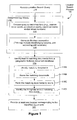
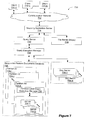
- Figure 1 is a flow diagram illustrating an embodiment of a location search process.
- Figure 2 is a block diagram illustrating an embodiment of processing a location search query.
- Figure 3 is a block diagram illustrating an embodiment of distributing geographic feature documents over a plurality of indexes.
- Figure 4 is a block diagram illustrating an embodiment of a geographic feature document.
- Figure 5A is a block diagram illustrating an embodiment of a map image.
- Figure 5B is a block diagram illustrating an embodiment of a map image.
- Figure 6 is a block diagram illustrating an embodiment of results that are returned in response to a location search query.
- Figure 7 is a block diagram illustrating an embodiment of a search engine system.
- Figure 8 is a block diagram illustrating an embodiment of a search engine.
- Figure 9 is a block diagram illustrating an embodiment of a client system.
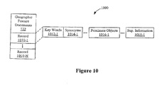
- Figure 10 is a block diagram illustrating an embodiment of a geographic features document data structure.
- Figure 11 depicts a set of geographic regions with respect to a current display window.
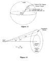
- Figures 12 and 13 show how distances and regions on the surface of the Earth are measured as normalized angular distances, and also show how the location of a geographic feature in a viewport skirt region is converted into a ratio value.
- Figure 14 depicts a graph of a function for determining the radius of a skirt region in accordance with the radius of a viewport region.
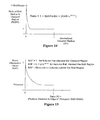
- Figure 15 depicts a graph of a function used to assign a score attenuation factor in accordance with the location of a geographic feature relative to a current viewport region and skirt region.
- Location search queries such as a street address in a city
- the location search queries are processed to determine a canonical or Boolean expression.
- the processing may include determining one or more key words in a respective location search query, removing punctuation marks and non-location terms (such as articles) from the respective location search query, and determining one or more synonyms for one or more terms in the respective location search query.
- the synonyms may include predetermined abbreviations for and/or predetermined misspellings of one or more terms in the respective location search query.
- the canonical expression may be independent of, i.e., insensitive to, an order of the key words.
- the canonical expression may be compared to an index of geographic feature documents in a search engine.
- Each geographical feature document has a set of tokens that correspond to a geographical feature, which may be a location (e.g., a street, city, country, state, country) or a geographical entity (e.g., lake, river, mountain, continent, ocean, etc.). While a single geographical feature may correspond to a set of locations, such as a set of street addresses, all the locations associated with a geographical feature may be considered to be "a location" in the context of identifying the locations or geographical features that best match a location search query.
- the terms "geographical feature" and "location” are used synonymously in at least some portions of this document.
- the index of geographical feature documents may be distributed over multiple computers in the search engine.
- the index may include location information and supplemental information.
- the location information may include key words, synonyms for the key words, and proximate objects for multiple locations.
- the supplemental information may include reference coordinates, such as latitude and longitude and/or a range or street numbers, for the locations.
- Scores for a subset of the geographic feature documents that are a close match to a respective canonical expression may be returned by the computers.
- a ranking of a top-N geographic feature document may be determined. If a best score is more than a pre-determined multiple of a next best score, the location corresponding to the best score may be provided to the user along with a map image of the corresponding location.
- the map image may be centered on the corresponding location and may be sized to include a pre-determined bounding box, region or window around the corresponding location. Alternatively, if the best score is less than the pre-determined multiple, several locations corresponding to a range of scores may be provided to the user. Additional information, such as a location identifier (city, state, zip code and/or country) and/or links to corresponding map images, may be provided.
- the embodiments may accommodate a wide variety of formats, allow for ambiguity in the location search query and/or in the results, and may be use parallel processing so as to provide high speed processing of location search queries (sometimes called location searching).
- the embodiments therefore, may provide improved processing of location search queries.
- Figure 1 is a flow diagram illustrating an embodiment of a location search process 100. While the location search process 100 described below includes a number of operations that appear to occur in a specific order, it should be apparent that the process 100 can include more or fewer operations, which can be executed serially or in parallel ( e.g. , using parallel processors or a multi-threading environment), an order of two or more operations may be changed and/or two or more operations may be combined into a single operation.
- a location search query may be received (110). Key words may be determined (112).
- the location search query may be converted into a canonical form (114). This may include removing one or more non-location or noise words or terms, punctuation marks, diacritical marks (i.e., a mark added to letter to indicate a special pronunciation), and/or street numbers from the location search query.
- a Boolean expression may be generated (116). The Boolean Expression may contain synonyms for one or more words or terms in the location search query. Converting the search query into canonical form may also include expanding one or more abbreviations, such as expanding "st,” or "st" into "street”.
- a misspelled word or term in the location search query may be "corrected" by supplementing the query with a "synonym" for the misspelled word that comprises the corresponding correctly spelled word. Determining the key words (112) may make a resulting query independent of the order of the key words.
- N e.g., ten
- best matching geographical feature documents may be identified from a geographic features document database (118). At least one geographical feature or location corresponding to the identified documents may be provided (120). Alternately, in some situations zero documents are provided to the requesting user.
- the list of N best matching geographical feature documents is filtered to remove (A) documents whose score is less than a first threshold, and (B) documents whose SAF (described below) is less than a second threshold and whose score is less than a third threshold (e.g., the third threshold would typically be higher (i.e., more restrictive) than the second threshold).
- the latter "filter” removes poor quality matches that exceed the first threshold, but which are far outside the current viewport (as defined below), thereby allowing another geographical feature or location within or closer to the current viewport to be identified as the best match.
- Identifying the N best matching documents 118 requires several computational operations.
- geographical feature documents satisfying the search query are identified 118A. For example, this may be accomplished by retrieving lists of documents having tokens that match each of the query terms and then performing a Boolean AND operation on the retrieved lists to produce a list of documents (if any) having tokens that match all the query terms.
- each token is a word, symbol or combination of words and/or symbols associated with a geographical feature.
- a document's tokens may include a variety of misspellings of various terms that describe the geographical feature associated with the document, and may include the names (and misspellings thereof) of neighboring or nearby geographical features (e.g., in case a user's search query incorrectly specifies a neighboring city or the like, but otherwise accurately lists terms associated with the geographical feature).
- the search query is first "rewritten," by removing any non-location terms and any punctuation, prior to identifying documents that satisfy the search query.
- a respective individual term in the search query can be replaced by a Boolean OR expression that includes the term and one or more synonyms.
- synonyms are added to the search query for each term in the query for which a set of synonyms has been predefined.
- the "synonyms” added to a search query as part of a Boolean OR expression may also include “generic synonyms” for individual components of compound terms. For example, a generic synonym of the first component of the street name "N Rengstorff" is "directional_keyword,” which matches any directional keyword, including N, S, E, W, North, South, East, and West.
- a generic synonym is "affix_keyword" which matches words (or tokens) such as ave., avenue, blvd., boulevard, In, lane, rd, road, st, street, rue and so on. Similar generic synonyms are also included as tokens in the document database, at the same address component positions as the corresponding "correct" keywords. Matches between generic synonyms in a rewritten search query and a document produce a significantly lower score than a match between a non-synonym keyword in the search query and a non-synonym token in a document.
- other modifications can be made to the search query in accordance with predefined rules so as to improve the quality of the search results.
- scores are computed for the identified matching documents 118B. Exemplary processes for generating the score for each matching document are discussed in some detail below. Generally, though, documents with high quality matches to the search query are assigned higher scores than documents with lower quality matches to the search query. Other factors, such as the locations of the geographical features corresponding to the matching documents, relative to a current viewport in which a map or image is displayed, and the relative importance of these geographical features, may also be factors in computing the scores.
- the matching documents are then ranked based on the computed scores 118C, and the N highest ranked documents are identified 118D. In some embodiments, the ranking of the documents and the selection of the N highest ranked documents is combined into a single operation (e.g., by running a top N filter over the scores). In some embodiments, documents having lower rank than the top N documents are not ranked.
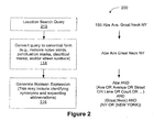
- FIG. 2 is a block diagram illustrating an embodiment 200 of processing a location search query.
- a location search query 210 such as "155 Abe Ave. Great Neck NY", is used as an illustrative example.
- the street number 155 and the period may be removed during operation 114 resulting in Abe Ave Great Neck NY.
- the location search query may be converted into a Boolean expression, including expanding abbreviations (such as Ave) and synonyms.
- the resulting Boolean expression is Abe AND (Ave OR Avenue OR Street OR Lane OR Court OR ...) AND (Great Neck) AND (NY OR (NEW YORK)).
- This Boolean expression is independent of, i.e., insensitive to, an original word or term order in the location search query 210. As such, it may accommodate a wide variety of formats for the location search query 210.
- Such a Boolean expression has a form that may be processed in a search engine using a distributed geographic feature document database. This is discussed further below.
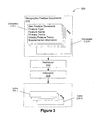
- FIG. 3 is a block diagram illustrating an embodiment 300 of distributing geographic feature documents over a plurality of indexes, which may be stored on multiple computers in a search engine.
- Geographic features documents 310 may include a plurality of geographic feature documents 312.
- a respective geographic feature document, such as document 312-1 may include a feature type (such as a street, road, route, city, country, intersection, etc.), a feature name (i.e., the name of a location), primary terms or tokens (such as specific key words associated with the feature), nearby feature terms or tokens (such as adjacent or proximate landmarks or locations of interest) and supplemental information (such as latitude and longitude of the feature).
- the supplemental information may be used by a map or tile server to present a map image(s) corresponding to the location in the respective geographic feature document. This is described further below with reference to Figures 5 and 7 .
- a partitioner 314 may distribute subsets of the geographic feature documents 310 via one or more indexers 316 to a respective index, such as index 320-1, in a plurality of indexes 320.
- the index 320-1 may correspond to one partition or sub-partition of the indexes 320 (which may collectively be considered to be the inverse index of the entire geographic feature documents database).
- the indexes 320 may be stored on one or more computers in the search engine.
- the subsets may be distributed such each index 320 handles an equivalent or approximately equivalent portion of processing associated with the respective location search query.
- the documents 312-1 may be distributed randomly or pseudo-randomly over the indexes 320.
- a hash function and modulo function may be used to distribute the geographic feature documents to M indexers, were M is the number of indexes (sometimes called index partitions or index sub-partitions).
- a hash function is applied to each geographic feature document (or to a predefined portion of the document) to produce a hash value, and then a "modulo M" function is applied to the hash value to produce a selection value between 0 and M-1. The selection value determines which of the M indexers 316 is to receive the document for indexing.
- each of the indexes 320 may provide a top-N (such as a top-10) set of documents in the subset of documents that match the respective query.
- the top-N documents may be based on a ranking of scores.
- a score may be determined for each document that matches the search query. The score may be based on the canonical and/or Boolean expression for the respective location search query.
- the query processing for each sub-partition of the index 320 is handled by a respective server 730, which returns information identifying up to N of the highest ranking documents that match the query.
- a server 726 that may be called an aggregator or partition level query execution manager combines the search results from the servers 730, for example by selecting the N best search results from among the results returned by the servers 730.
- query execution manager 720 the search results from all the aggregators 726 are combined, by selecting the N best search results from among the results returned by the aggregators 720. More generally, a predefined number of best search results are selected at each level in a distributed hierarchy and are passed on to the next level. For example, if 10 sets of top-10 documents are received at a given level, the top-10 documents may be determined and passed on. In this way, the top-N documents in the documents 312 may be determined and/or identified using a distributed implementation. This approach may improve performance of the search engine and may reduce system cost and/or complexity.
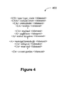
- FIG. 4 is a block diagram illustrating an embodiment of a geographic feature document 400, such as the document 312-1.
- the document 400 may be compatible with hypertext markup language (HTML) and/or extensible markup language (XML).
- the document 400 may include information corresponding to a geographic feature, such as a location (e.g., a street, intersection, city, point of interest, etc.).
- Some documents 400 may include information for more than one location (e.g., multiple segments of a street, city, or the like).
- Such location information may include key words corresponding to the one or more locations, one or more regions associated with the one or more locations and synonyms for one or more of the key words.
- text following an HTML tag ⁇ CN> may indicate a type of location, in this case a route.
- Text following an HTML tag ⁇ CNA> may indicate an explicit name for the location, in this case Victoria Street.
- Text following HTML tags ⁇ CA> may indicate key words corresponding to the location, such as Riverside, London and England.
- Text following HTML tags ⁇ A> may indicate synonyms for the key words and/or the explicit name for the location, such as Sullivan, London and England.
- the synonyms may include words from foreign languages (i.e., languages other than the language of the key words).
- the synonyms may include abbreviations and/or common misspellings in one or more keywords and/or in the explicit name for the location.
- Text following HTML tags ⁇ Cn> may indicate other locations or regions that are nearby or that neighbor the location. In this example, the nearby locations or regions are Islington, West End and Covent Garden.
- the tagged text or information items in a document 400 may be called information items or text items or tokens.
- the information items or text items are processed by the indexers 316 ( Figure 3 ) to produce the indexes 320.
- the document 400 may include less information or additional information, including fewer or additional tags.
- the document 400 may include supplemental information, such as reference coordinates corresponding to the geographic features, that may be used by a map or tile server.
- the reference coordinates may include latitudes and longitudes for one or more locations and/or a range of street numbers that bracket one or more locations.
- an order of the information in the document 400 may be changed. Two or more items in the document 400 may be combined into a single item.
- supplemental information in a document 400 is the supplemental information for street or other route.
- the supplemental information includes one or more segments, each corresponding to a portion of the street or route. Each segments specifies a beginning and ending street number corresponding to first and second ends of the segment, and also specifies a latitude and longitude for each end of the segment.
- the specified street number is used to identify the best matching segment in the document's supplemental information. If the specified street number falls between the beginning and ending street numbers for the best matching segment, linear interpolation is used to determine a latitude and longitude for the location specified by the location search query. Alternately, if the specified street number matches the beginning or ending street number for the best matching segment, then the corresponding latitude and longitude are used for the location of the location specified by the location search query.
- scores indicative of a degree of matching may be determined. These scores may indicate a relevancy of the documents 212, and thus, the corresponding locations, to the location search query. As such, the scores may be used by the search engine to determine a best result, i.e., a best location, or a list of the top-N results, i.e., the top-N locations, in response to the location search query.
- scores may only be determined for a subset of the documents 312 ( Figure 3 ), i.e., the search engine may determine a candidate set of documents that may correspond to the location search query.
- criteria for inclusion in the candidate set of documents may include a requirement that at least one of the key words match the explicit name of the feature (the text following the ⁇ CNA> tag in Figure 4 ) and that each of the elements or terms in the canonical and/or Boolean expression occurs in a document.
- the scores may be determined using 1 E ⁇ i lR i ⁇ FR ⁇ Q , where TR i is a query match score (with respect to a particular candidate document) corresponding to a respective term or element "i" in the canonical and/or Boolean expression, FR is "feature rank" that indicates an importance of the feature or location, E is a normalization value, and Q is an optional factor.
- Q may correspond to the quality of the match between the query and the candidate document, or it may correspond to any other metric that may be used to improve the quality of the search results.
- An example of the Q factor is the SAF factor described below with reference to Figures 11-15 .
- Q is set equal to SAF*Product(P j ), where SAF is the score attenuation factor described below, each P j is a penalty factor, and Product(P j ) is the product (i.e., the multiplicative product) of all the penalty factors.
- SAF is the score attenuation factor described below
- P j is a penalty factor
- Product(P j ) is the product (i.e., the multiplicative product) of all the penalty factors.
- Each of the penalty factors has a default value of 1.0, and is assigned a lower value (e.g., 0.7 or the like) if the corresponding penalty is applicable to the document in question.
- penalty factors are: A) a penalty factor that is applied when the document is neither in the user's country nor in his current viewport (as defined below); B) a penalty factor that is applied when the match between the document and the query is an inexact match (e.g., because the query contains an extraneous or mistaken term or symbol, and the only match between the mistaken term or symbol and the document is a match with a "generic synonym" token (see explanation above concerning "generic synonyms")); and C) a penalty factor that is applied when the match between the query and the document is missing a key element (e.g., when the query matches a street name token and a country token, but not a city token of the document).
- Other penalty factors may be used in other embodiments.
- penalty factors are associated with situations indicative of a potentially poor quality match between a geographical feature document and a search query.
- Q is not used, or equivalently is set equal to 1.
- the normalization value, E is the maximum value of the sum of the IP i scores for a perfect match, or equivalently the sum of the token masses for the key words in the search query.
- the sum of the IR i values may be called the total match score or IR score for the candidate document.
- the value of IR i for a particular key word in the search query may include a product of weights.
- the weights may include a token mass, a relevance score and an element mass for the corresponding element or term in the canonical and/or Boolean expression.
- the token mass may correspond to a type of term, where the types of terms may include stop words, street affix key words (e.g., a street prefix word such as “rue” in French, or street suffix words such as “street,” “avenue,” “road,” and “place” in English), numbers, synonyms, and other key words, with each predefined type of term being assigned a predefined token mass.
- the predefined token mass values may have a predefined range, such as 0 to 1, or 0 to 8, or the like.
- the default token mass (for "other key words") is 1, while token types such as synonyms, and street affix key words and stop words are all assigned lower token mass values.
- synonyms are assigned a larger token mass than street affix words.
- the relevance score may vary based on the degree of text match, with a predefined largest value for a complete text match between a query key word and an information element of the document.
- a predefined largest value for a complete text match between a query key word and an information element of the document When the best match of a query key word with the information elements of a document is only a partial match (e.g., the query key word matches only one word of a multiword element), the relevance score is less than the predefined largest value, and reflects the degree of text match.
- the element mass may vary as a function of a size or type of the geographic feature associated with an information item (in the candidate document) that matches a query key word. For example, an information item that is country name may be given a higher element mass than an information item that is a locality name (such as a city name), which in turn is given a higher value than an information that is a street name.
- the element mass may also reflect the type of information item that matches the query key word.
- the information item that contains the explicit name for the geographical feature may be assigned a highest element mass
- an information item that is a "context" item e.g., the city or country in which a street is located
- an information item that contains the name of a nearby city, region or other geographical feature may be assigned a lowest element mass.
- the element mass for an information item in a candidate document is equal to the product of two element mass factors, one of which is based on the size or type of the geographical feature named by the information item and the second of which is based on the type of information item (explicit name, context, or nearby feature) that matches the query key word.
- the element mass for an information item in a candidate document is equal to the sum of these two element mass factors.
- the feature rank, FR, for a candidate document may be based on a document frequency (a number of times a feature is referenced in the documents 312 in the database 310, Figure 3 ), or it may be based on the size of a geographic feature, with bigger features (i.e., geographic extent) given higher feature rank values.
- the feature rank can be based, at least in part, on the importance or popularity of the geographic feature corresponding to the candidate document. For example, the importance or popularity of the geographic feature corresponding to a candidate document may be determined by a worldwide-web search or other database search on the name of the geographic feature.
- an IR score is computed (with respect to a candidate document) for each of the synonyms and for the query key word, and then the best of those IR scores is selected and used when computing the combined IR score for the candidate document.
- the scoring function shown above is modified so as to increase the importance of one or more factors relative to the other factors.
- the scoring function may be changed to 1 E ⁇ i lR i M ⁇ FR ⁇ Q , where the exponent, M, is a value greater than one (e.g., 2, 2.5 or 3), and is typically between two and five (2 ⁇ M ⁇ 5), so as give the normalized total match score more importance in the scoring function than the feature rank, FR, and Q factors.
- the scoring function discussed above is modified to favor documents whose name has terms in the same order as the terms are positioned in the search query over documents matching the same terms, but which have the terms in a different order in their name.
- the total match score may be supplemented (e.g., total match score + pair-wise match score) with a pair-wise matching score (e.g., total match score + pair-wise match score), which is based on the number of ordered term pairs (ordered, neighboring terms) in the search query that match ordered terms pairs in the document name.
- a pair-wise matching score e.g., total match score + pair-wise match score
- FIG. 5A is a block diagram illustrating an embodiment of a map image 500 provided to the user.
- a location tag 512-1 corresponding to the location is centered in a bounding box 510.
- the bounding box 510 is sized such that a region 514 surrounding the location may be provided.
- the size of the bounding box 510 may be determined based on the size of the geographic feature or location. Different sized features (such as cities or countries) may have different sized bounding boxes.
- more than one distinct location (i.e., spatially separated from one another) in a region may have the same or almost the same score.
- more than one location may match all of the key words in the canonical and/or Boolean expression corresponding to the location search query. In such cases, these results may be provided to the user.
- Figure 5B is a block diagram illustrating an embodiment of a map image 550.
- a bounding box 510 is defined which includes all the locations that meet predefined selection criteria.
- Location tags 512 corresponding to the distinct locations are included in the bounding box 510.
- the tags are links. By clicking on one of the tags, the user may select the corresponding location.
- This location may be presented to the user along with a map image, such as the map image 500 ( Figure 5A ).
- a list 520 of the best matching locations is listed next to the map 550.
- Each item in the list may include a link to a map corresponding to that location.
- Each item in the list 520 may be represented by the canonical name (identified by a CNA tag in the example in Figure 4 ) and the context text (identified by the CA tags in the example in Figure 4 ) from the corresponding geographical feature document.
- locations corresponding to a range in the top-N ranking may be provided. For example, locations (from among the top N results) having scores greater than or equal to 50% of the best score may be provided. A variety of information may be provided along with the locations.
- An exemplary graphical user interface for showing multiple search results returned in response to a location search query is shown in Figure 6 . In one region 610 or column, the best matching geographic features or locations are listed, and in another region of the graphical user interface are shown individual small maps 620, one for each of the best matching geographic features or locations listed in region 610. In this example, the location search query was "San Antonio," which produced several possible relevant answers.
- the answers may be provided with one or more location identifiers, such as a city, a state, a zip code, and/or a country.
- the small maps 620 each include a link to a corresponding, larger map.
- each of the listed best matching locations in region 610 include a link to a corresponding larger map. Clicking on one of the answers or small maps may allow the location to presented to the user along with a map image, such as the map image 500 ( Figure 5A ).
- FIG. 7 is a block diagram illustrating an embodiment of a search engine system 700 that generates location search query results in response to location search queries received from one or more clients 710 (also herein called client devices or client systems), such as client system or device 900 ( Figure 9 ).
- clients 710 also herein called client devices or client systems
- Each client 710 may have a search assistant, such as search assistant module 930 ( Figure 9 ).
- search assistant module 930 Figure 9
- the search engine system 700 may include fewer or additional components or modules, may be implemented in hardware and/or in software, and a location or one or more components or modules may be changed.
- the search engine system 700 is used to search an index of documents, such as the geographic feature documents 310 ( Figure 3 ).
- the search engine system 700 may include a mapping application server 714 that communicates with the clients 710 using a communication network 712.
- the communication network 712 may be the Internet and/or an intranet.
- the mapping application server 714 may forward location search queries to query server 716 and receive location results from the query server 716.
- the mapping application server 714 may use the supplemental information in the locations results to access appropriate map images from tile server 718 and to provide such map images along with the location results to the clients 710.
- the query server 716 may determine the key words in the location search query, including converting the location search query to canonical form and/or generating a Boolean expression.
- the canonical and/or Boolean expression may be forwarded to query execution manager 720 for processing.
- the query execution manager 720 may provide the canonical and/or Boolean expression to multiple partitions 724 in geographic features documents database 722.
- a partition level query execution manager 726 may distribute the canonical and/or Boolean expression to servers 730 for one partition.
- the servers 730 may store the indexes 320 ( Figure 3 ).
- the servers in the geographic features documents database 722 may determine the top-N documents corresponding to the location search query in a hierarchical fashion.
- the query execution manager 720 may access corresponding geographic or location information, such as the supplemental information, in document servers 734.
- the geographic or location information may be included in the geographic features documents database 722.
- Elements in the search engine system 700 may be dispersed over a group of servers so as to provide very fast processing of location search queries.
- the system 700 may include replicas of the query server, query execution manager, tile server and geographic features documents database at multiple locations, in a plurality of datacenters (e.g., located on different continents, and/or at different locations within one or more countries).
- Location search queries submitted by users at one of the clients 710 to the search engine system 700 are routed to an appropriate datacenter using the Domain Name System (DNS), based on current load, geographic locality and/or the operational status of each of the datacenters.
- DNS Domain Name System
- Each backend preferably includes multiple query servers, such as query server 716, coupled to a communications network 712.
- the communications network 712 may be the Internet, but may also be any local area network (LAN) and/or wide area network (WAN).
- each query server 716 is a server that receives location search query requests and delivers search location results in the form of web pages via HTTP, XML or similar protocols.
- the query server 716 is used within a LAN, i.e., internally and not by the public, it may be an Intranet server.
- the query servers, such as query server 716 are configured to control the search process, including searching a document index, analyzing and formatting the search results.
- a backend includes multiple query execution managers 720, coupled to the multiple query servers, such as the query server 716.
- FIG. 8 is a block diagram illustrating an embodiment of a search engine 800.
- the search engine 800 may include at least one data processor or central processing unit (CPU) 810, a communications or network interface 820 for communicating with other computers, servers and/or clients, memory 822 and one or more signal lines 812 for coupling these components to one another.
- the one or more signal lines 812 may constitute one or more communications buses.
- Memory 822 may include high-speed random access memory and/or non-volatile memory, such as one or more magnetic disk storage devices.
- Memory 822 may store an operating system (or a set of instructions) 824, such as LINUX, UNIX or WINDOWS, that includes procedures for handling basic system services and for performing hardware dependent tasks.
- Memory 822 may also store communication procedures (or a set of instructions) in a network communication module 826. The communication procedures are used for communicating with clients, such as the clients 710 ( Figure 7 ), and with other servers and computers in the search engine system 700 ( Figure 7 ).
- Memory 822 may also store a query server module (or a set of instructions) corresponding to the query server 716 ( Figure 7 ), geographic feature document database 722, documents 832 and selected results 836.
- the query server module 716 may include a key word processor 828, which may rewrite received search queries, as described above.
- the geographic feature document database 722 may include multiple indexes 830.
- the documents 832 may include multiple documents 834 that include geographic or location information.
- the selected results 836 may include results 838 to one or more location search queries.
- Figure 8 (like Figure 7 ) shows search engine 800 as a number of discrete items
- Figure 8 is intended more as a functional description of the various features which may be present in a search engine system rather than as a structural schematic of the embodiments described herein.
- the functions of the search engine 800 may be distributed over a large number of servers or computers, with various groups of the servers performing particular subsets of those functions. Items shown separately in Figure 8 could be combined and some items could be separated. For example, some items shown separately in Figure 8 could be implemented on single servers and single items could be implemented by one or more servers.
- the actual number of servers in a search engine system and how features are allocated among them will vary from one implementation to another, and may depend in part on the amount of information stored by the system and/or the amount data traffic that the system must handle during peak usage periods as well as during average usage periods.
- FIG. 9 is a block diagram illustrating an embodiment of a client computer, device or system 900.
- Client system 900 may be a desktop computer, laptop computer, personal digital assistant (PDA), cell phone, personal navigation device, or the like.
- Client system 900 generally includes one or more processing units (CPU's) 910, a user interface 914, one or more network or other communications interfaces 912, memory 922, and one or more communication buses 920 for coupling these components.
- the user interface 914 may include one or more keyboards 918, one or more displays 916, and/or one or more pointers (not shown), such as a mouse.
- Memory 922 may include random access memory, such as DRAM, SRAM, DDR RAM or other random access solid state memory devices; and may include non-volatile memory, such as one or more magnetic disk storage devices, optical disk storage devices, flash memory devices, or other non-volatile solid state storage devices.
- the communication buses 920 may include circuitry (sometimes called a chipset) that interconnects and controls communications between system components.
- Memory 922 may include mass storage that is remotely located from the central processing unit(s) 910.
- memory 922 may include an operating system (or a set of instructions) 924, a network communications module (or a set of instructions) 926, a browser/tool module 928 and/or a search assistant module (or a set of instructions) 930.
- the search assistant module 930 may include an entry and selection monitoring module (or a set of instructions) 932, a transmission module (or a set of instructions) 934, a search results receipt module (or a set of instructions) 936 and/or a display module (or a set of instructions) 936.
- the operating system 924 such as LINUX, UNIX or WINDOWS, may include procedures (or sets of instructions) for handling various basic system services and for performing hardware dependent tasks.
- the network communication module 926 may be used to connect client system 900 to other computers (e.g., other client computers and/or a search engine) via the one or more communication network interfaces 912 and one or more communication networks, such as the Internet, other wide area networks, local area networks, metropolitan area networks, and so on.
- the browser/tool module 928 may be a web browser that a user of the client system 900 may use to communicate and/or exchange information with one or more hosts (such as one or more websites and/or web pages) on the one or more communication networks. For example, the user may surf the Internet (e.g., display a web page and/or a web site) using the browser/tool module 928.
- hosts such as one or more websites and/or web pages
- the user may surf the Internet (e.g., display a web page and/or a web site) using the browser/tool module 928.
- the search assistant module 930 may be used by the user to perform one or more search queries, such as location search queries, using a search engine and to receive corresponding search results, including one or more locations, one or more map images, one or more URLs and/or hyperlinks.
- the entry and selection monitoring module 932 may monitor user input, the transmission module 934 may send a search query to the search engine, the search results receipt module 936 may receive the search results from the search engine, and the display module 938 may display the search results (or may assist in rendering the search results for display by the browser module 928), such as a ranking of the one or more documents and/or document locations that contain identified content corresponding to the search query.
- the user may access or select one or more of the documents and/or document locations in the search results using the user interface 914 and the browser/tool module 928. For example, the user may click on a hyperlink using the pointer (not shown).
- one or more of the modules and/or applications in memory 922 may be stored in the server computer, which is typically at a different location than the client system 900.
- Each of the above identified modules and applications corresponds to a set of instructions for performing one or more functions described above. These modules (i.e., sets of instructions) need not be implemented as separate software programs, procedures or modules.
- the various modules and sub-modules may be rearranged and/or combined.
- Memory 922 may include additional modules and/or sub-modules, or fewer modules and/or sub-modules.
- the search assistant module 930 may be integrated into the browser/tool module 928. Memory 922 may, therefore, include a subset or a superset of the above identified modules and/or sub-modules.
- FIG 10 is a block diagram illustrating an embodiment of a geographic feature document data structure 1000.
- the geographic feature documents data structure 1000 may include geographic feature documents 722.
- the geographic feature documents 722 may include multiple records 1010 that are distributed over multiple partitions on multiple computers.
- Each record 1010 may correspond to a respective geographic feature document.
- the geographic feature documents may correspond to geographic features or locations.
- the records may include key words 1012, synonyms 1014 for one or more key words, associated words 1016 (such as a city where the location occurs) and/or proximate objects 1018.
- the geographic feature documents data structure 1000 may include fewer or additional elements, two or more elements may be combined and positions of one or more elements may be changed.
- a respective record 1010 may further include the supplemental information 1018, including latitude and longitude information for one or more locations or bounding boxes associated with the geographic feature represented by the record 1010.
- geographic features e.g., cities, streets, specific addresses, or the like
- the user is often searching for geographic features (e.g., cities, streets, specific addresses, or the like) that are nearby the geographic feature(s) found in the immediately prior location search. For example, after searching for a first geographic feature in a particular city, the user will often search for a second geographic feature that is either in the same city, or in a neighboring or nearby city.
- geographic features are sometimes called "locations,” but it should be understood that some geographic features, such as a street (as opposed to a specific street address), correspond to a large number of locations.
- the "viewport" or “current viewport” corresponds to the geographic region currently displayed on the user's client device or system.
- the viewport may be the display window produced (e.g., by an online mapping program or service) in response to the immediately preceding location search, or it may be a circular region that bounds the viewport rectangle displayed on the user's client system.
- the viewport can be rectangular or circular in shape.
- the viewport is assumed to be circular in shape and to surround and include the viewport rectangle displayed on the user's client system.
- the viewport may result from user actions (e.g., pan and/or zoom commands or actions) that change the viewport to a user-specified region.
- the results may be scored so as to favor results (i.e., locations) within the current viewport over locations outside the viewport, and to favor locations near the viewport (e.g., within a skirt region around the viewport, herein called the "viewport skirt region”) than locations further away from the viewport.
- the scoring function described above for scoring "documents” (sometimes called location description documents or location description database entries) is modified to include a score attenuation factor (SAF), which biases the score to favor results that intersect the current viewport, and to favor results that intersect a viewport skirt region that surrounds the viewport over results that intersect neither the viewport region nor the viewport skirt region (i.e., which are outside the viewport skirt region).
- SAF score attenuation factor
- intersect means that at least a portion of the geographic feature identified by a search result falls within a particular region.
- the sizes of regions and distances on the surface of the earth may be measured in terms of "angular distances", which is the angular size of the arc on the earth's surface that is subtended by those regions or distances.
- Angular distances may be measured in units of radians or degrees. Normalized angular distances are divided by a normalization factor, such as 2 ⁇ , so that the maximum angular distance is 1 (or any other predefined value) and the minimum angular distance is 0.
- X1 represents the normalized size of the viewport region, based on the angular distance of the viewport region's radius R1.
- X2 is the normalized size of the viewport skirt region, based on the angular distance of the viewport skirt region's radius R2.
- X2-X1 represents the width of the viewport skirt region.
- X3 represents the normalized angular distance between a geographical feature and the closest edge of the viewport region, or more generally the distance between the geographical feature and the viewport region.
- X represents the ratio of (A) the distance between the geographical feature and the viewport region, and (B) the width of the viewport skirt region.
- the size of the viewport skirt region depends on the size of the viewport region.
- the radius of the viewport region is small (e.g., less than a few kilometers)
- the radius of the viewport skirt region is as much as 1+SkirtFactor times as large as the radius of the viewport region, where SkirtFactor is a configurable parameter.
- the radius of the viewport region is large (e.g., more than a few hundred kilometers)
- the radius of the viewport skirt region is approximately the same as the radius of the viewport region.
- SkirtFactor is 10; in other embodiments, SkirtFactor is equal to a value between 4 and 20.
- M is a configurable exponential rate factor.
- An exemplary value of M is 50; in other embodiments, M is equal to a value between 10 and 200.
- Score 1 E ⁇ i lR i ⁇ FR ⁇ SAF
- the sum of the IR i values for a particular candidate document (or geographical feature) can be considered to be an information retrieval score or query match score for the candidate, and that all the other parameters of the scoring function are for scaling, boosting or attenuating the score in accordance with additional factors so as to improve how the search results are ranked (i.e., so that the topmost ranked search results are the search results that are most likely to correspond to the geographical feature that is being sought by the user).
- C and D are values that are selected so that SAF equals its minimum value, MinScore, when X is equal to 1 (i.e., when the geographical feature is in the outermost portion of the skirt region, and is equal to its maximum value, 1, when X is equal to zero (i.e., when the geographical feature intersects or is adjacent the line or boundary between the viewport region and the viewport skirt region).
- MinScore MinScore - e - K 1 - e - K + 1 - MinScore ⁇ e - K ⁇ X 1 - e - K .
- MinScore is approximately equal to 0.158 + 0.842*e -3X for geographic features that intersect the viewport skirt region (but do not intersect the viewport region).
- SAF is approximately equal to 0.158 + 0.842*e -3X for geographic features that intersect the viewport skirt region (but do not intersect the viewport region).
- SAF is equal to 1 for geographic features that intersect the viewport region, and is equal to MinScore (e.g., 0.2) for geographic features that intersect neither the viewport region nor the viewport skirt region.
- MinScore is a value between 0.1 and 0.5
- K is a value between 2 and 10.
Landscapes
- Engineering & Computer Science (AREA)
- Databases & Information Systems (AREA)
- Theoretical Computer Science (AREA)
- Data Mining & Analysis (AREA)
- Physics & Mathematics (AREA)
- General Engineering & Computer Science (AREA)
- General Physics & Mathematics (AREA)
- Information Retrieval, Db Structures And Fs Structures Therefor (AREA)
- Instructional Devices (AREA)
Applications Claiming Priority (3)
| Application Number | Priority Date | Filing Date | Title |
|---|---|---|---|
| US76316806P | 2006-01-27 | 2006-01-27 | |
| US86954906P | 2006-12-11 | 2006-12-11 | |
| EP07710328A EP1979841A1 (fr) | 2006-01-27 | 2007-01-26 | Codage géographique pour des requêtes recherche de position |
Related Parent Applications (1)
| Application Number | Title | Priority Date | Filing Date |
|---|---|---|---|
| EP07710328.1 Division | 2007-01-26 |
Publications (1)
| Publication Number | Publication Date |
|---|---|
| EP2538356A1 true EP2538356A1 (fr) | 2012-12-26 |
Family
ID=37887978
Family Applications (2)
| Application Number | Title | Priority Date | Filing Date |
|---|---|---|---|
| EP12179688A Withdrawn EP2538356A1 (fr) | 2006-01-27 | 2007-01-26 | Codage géographique pour des requêtes de recherche de localisation |
| EP07710328A Withdrawn EP1979841A1 (fr) | 2006-01-27 | 2007-01-26 | Codage géographique pour des requêtes recherche de position |
Family Applications After (1)
| Application Number | Title | Priority Date | Filing Date |
|---|---|---|---|
| EP07710328A Withdrawn EP1979841A1 (fr) | 2006-01-27 | 2007-01-26 | Codage géographique pour des requêtes recherche de position |
Country Status (5)
| Country | Link |
|---|---|
| EP (2) | EP2538356A1 (fr) |
| JP (1) | JP5325579B2 (fr) |
| CN (2) | CN101410833B (fr) |
| CA (1) | CA2640365C (fr) |
| WO (1) | WO2007087629A1 (fr) |
Families Citing this family (20)
| Publication number | Priority date | Publication date | Assignee | Title |
|---|---|---|---|---|
| US7987195B1 (en) | 2008-04-08 | 2011-07-26 | Google Inc. | Dynamic determination of location-identifying search phrases |
| US9092454B2 (en) * | 2008-04-22 | 2015-07-28 | Microsoft Technology Licensing, Llc | Discovering co-located queries in geographic search logs |
| CN101661461B (zh) * | 2008-08-29 | 2016-01-13 | 阿里巴巴集团控股有限公司 | 确定文档中核心地理信息的方法、系统 |
| CN101546342B (zh) * | 2009-05-08 | 2012-07-04 | 阿里巴巴集团控股有限公司 | 实现搜索服务的方法与系统 |
| JP2011124287A (ja) | 2009-12-08 | 2011-06-23 | Sony Corp | 発電量予測装置、発電量予測システム、発電量予測方法及びコンピュータプログラム |
| US20120158712A1 (en) | 2010-12-16 | 2012-06-21 | Sushrut Karanjkar | Inferring Geographic Locations for Entities Appearing in Search Queries |
| US8688366B2 (en) * | 2011-07-19 | 2014-04-01 | Navteq B.V. | Method of operating a navigation system to provide geographic location information |
| US8806322B2 (en) * | 2011-11-28 | 2014-08-12 | Google Inc. | System and method for obtaining a structured address by geocoding unstructured address information |
| EP2883152A4 (fr) * | 2012-08-10 | 2016-03-16 | Nokia Technologies Oy | Procédé et appareil conçus pour assurer un géocodage obtenu par externalisation ouverte |
| US8965900B2 (en) * | 2012-09-14 | 2015-02-24 | Bentley Systems, Incorporated | Efficiently finding spatially scored best entities |
| CA2906767A1 (fr) * | 2013-03-15 | 2014-09-18 | The Dun & Bradstreet Corporation | Desambiguisation non deterministe et mise en correspondance de donnees locales d'entreprises |
| CN104375992B (zh) * | 2013-08-12 | 2018-01-30 | 中国移动通信集团浙江有限公司 | 一种地址匹配的方法和装置 |
| US20160132567A1 (en) * | 2014-11-12 | 2016-05-12 | Microsoft Corporation | Multi-search and multi-task in search |
| CN106855868A (zh) * | 2015-12-09 | 2017-06-16 | 北京奇虎科技有限公司 | 地图搜索结果的显示方法及装置 |
| JP7464462B2 (ja) * | 2016-04-28 | 2024-04-09 | オナー デバイス カンパニー リミテッド | ヒューマンコンピュータインタラクション方法およびその装置 |
| JP6725693B2 (ja) | 2016-04-28 | 2020-07-22 | 華為技術有限公司Huawei Technologies Co.,Ltd. | ヒューマンコンピュータインタラクション方法およびその装置 |
| US11574074B2 (en) * | 2017-12-11 | 2023-02-07 | Digital Guardian Llc | Systems and methods for identifying content types for data loss prevention |
| US11531779B2 (en) | 2017-12-11 | 2022-12-20 | Digital Guardian Llc | Systems and methods for identifying personal identifiers in content |
| CN112115100A (zh) * | 2019-06-20 | 2020-12-22 | 珠海金山办公软件有限公司 | 一种文档搜索方法、系统、存储介质和终端 |
| CN117435823B (zh) * | 2023-12-19 | 2024-03-29 | 北京智网易联科技有限公司 | 基于网格编码的时空数据服务方法及工业互联网平台 |
Citations (2)
| Publication number | Priority date | Publication date | Assignee | Title |
|---|---|---|---|---|
| WO2001065410A2 (fr) * | 2000-02-28 | 2001-09-07 | Geocontent, Inc. | Moteur de recherche sur l'internet |
| US20050065916A1 (en) * | 2003-09-22 | 2005-03-24 | Xianping Ge | Methods and systems for improving a search ranking using location awareness |
Family Cites Families (4)
| Publication number | Priority date | Publication date | Assignee | Title |
|---|---|---|---|---|
| KR19990069299A (ko) * | 1998-02-06 | 1999-09-06 | 윤종용 | 특정 위치에 속한 정보를 찾는 웹 검색 방법 |
| JP2000200282A (ja) * | 1999-01-06 | 2000-07-18 | Seiko Epson Corp | 情報検索方法及び情報検索システム並びに情報検索処理プログラムを記録した記録媒体 |
| EP3367268A1 (fr) * | 2000-02-22 | 2018-08-29 | Nokia Technologies Oy | Codage spatial et affichage d'informations |
| JP4153887B2 (ja) * | 2004-03-19 | 2008-09-24 | 株式会社日立製作所 | 移動体ナビゲーション装置、および、移動体ナビゲーション装置における目的地の検索方法 |
-
2007
- 2007-01-26 WO PCT/US2007/061133 patent/WO2007087629A1/fr active Application Filing
- 2007-01-26 CA CA2640365A patent/CA2640365C/fr active Active
- 2007-01-26 EP EP12179688A patent/EP2538356A1/fr not_active Withdrawn
- 2007-01-26 EP EP07710328A patent/EP1979841A1/fr not_active Withdrawn
- 2007-01-26 CN CN2007800106150A patent/CN101410833B/zh active Active
- 2007-01-26 JP JP2008552594A patent/JP5325579B2/ja active Active
- 2007-01-26 CN CN201110276324.4A patent/CN102354312B/zh active Active
Patent Citations (2)
| Publication number | Priority date | Publication date | Assignee | Title |
|---|---|---|---|---|
| WO2001065410A2 (fr) * | 2000-02-28 | 2001-09-07 | Geocontent, Inc. | Moteur de recherche sur l'internet |
| US20050065916A1 (en) * | 2003-09-22 | 2005-03-24 | Xianping Ge | Methods and systems for improving a search ranking using location awareness |
Non-Patent Citations (2)
| Title |
|---|
| JIANTING ZHANG ET AL: "A GML-based open architecture for building a geographical information search engine over the internet", WEB INFORMATION SYSTEMS ENGINEERING, 2001. PROCEEDINGS OF THE SECOND INTERNATIONAL CONFERENCE ON, PISCATAWAY, NJ, USA,IEEE, vol. 2, 3 December 2001 (2001-12-03), pages 25 - 32, XP010589419, ISBN: 0-7695-1393-X * |
| MORIMOTO Y ET AL: "Extracting spatial knowledge from the web", APPLICATIONS AND THE INTERNET, 2003. PROCEEDINGS. 2003 SYMPOSIUM ON 27-31 JAN. 2003, PISCATAWAY, NJ, USA,IEEE, 27 January 2003 (2003-01-27), pages 326 - 333, XP010629019, ISBN: 0-7695-1872-9 * |
Also Published As
| Publication number | Publication date |
|---|---|
| CA2640365A1 (fr) | 2007-08-02 |
| CN102354312B (zh) | 2014-11-05 |
| CA2640365C (fr) | 2015-03-17 |
| JP5325579B2 (ja) | 2013-10-23 |
| CN101410833B (zh) | 2011-09-28 |
| EP1979841A1 (fr) | 2008-10-15 |
| CN101410833A (zh) | 2009-04-15 |
| CN102354312A (zh) | 2012-02-15 |
| WO2007087629A1 (fr) | 2007-08-02 |
| JP2009524893A (ja) | 2009-07-02 |
Similar Documents
| Publication | Publication Date | Title |
|---|---|---|
| US7747598B2 (en) | Geographic coding for location search queries | |
| US7792883B2 (en) | Viewport-relative scoring for location search queries | |
| CA2640365C (fr) | Codage geographique pour des requetes recherche de position | |
| US8463774B1 (en) | Universal scores for location search queries | |
| US7657504B2 (en) | User interface for displaying images of sights | |
| US7117199B2 (en) | Spatially coding and displaying information | |
| US8015183B2 (en) | System and methods for providing statstically interesting geographical information based on queries to a geographic search engine | |
| US20090019066A1 (en) | Hybrid location and keyword index | |
| US8538956B1 (en) | Geocoding results using geotopic annotation of web search results | |
| US20020199018A1 (en) | Maping physical locations to web sites | |
| CA2495560A1 (fr) | Interaction de client de table avec un systeme de recherche geographique de texte | |
| US8694512B1 (en) | Query suggestions | |
| KR20000030486A (ko) | 지역정보 검색전용 인터넷 정보 검색 시스템 및 이를이용한 인터넷 정보 검색 방법 | |
| US20090234829A1 (en) | Link based ranking of search results using summaries of result neighborhoods | |
| Lee et al. | Map-based range query processing for geographic web search systems | |
| Lin | Classification practice and implications for subject directories of the chinese language web-based digital library | |
| Kozanidis et al. | Focusing Web Crawls On Location-Specific Content. | |
| Lindgaard et al. | Automatic geo-referencing of web-pages |
Legal Events
| Date | Code | Title | Description |
|---|---|---|---|
| PUAI | Public reference made under article 153(3) epc to a published international application that has entered the european phase |
Free format text: ORIGINAL CODE: 0009012 |
|
| AC | Divisional application: reference to earlier application |
Ref document number: 1979841 Country of ref document: EP Kind code of ref document: P |
|
| AK | Designated contracting states |
Kind code of ref document: A1 Designated state(s): AT BE BG CH CY CZ DE DK EE ES FI FR GB GR HU IE IS IT LI LT LU LV MC NL PL PT RO SE SI SK TR |
|
| RIN1 | Information on inventor provided before grant (corrected) |
Inventor name: TRAN, THAI Inventor name: RASMUSSEN, LARS EILSTRUP Inventor name: BURON, FLORIAN MICHEL Inventor name: BALAKRISHNAN, RAMESH Inventor name: NORRIS, JAMES CHRISTOPHER Inventor name: MULLER, JAMES ROBERT |
|
| 17P | Request for examination filed |
Effective date: 20130626 |
|
| RBV | Designated contracting states (corrected) |
Designated state(s): AT BE BG CH CY CZ DE DK EE ES FI FR GB GR HU IE IS IT LI LT LU LV MC NL PL PT RO SE SI SK TR |
|
| 17Q | First examination report despatched |
Effective date: 20151125 |
|
| RAP1 | Party data changed (applicant data changed or rights of an application transferred) |
Owner name: GOOGLE LLC |
|
| STAA | Information on the status of an ep patent application or granted ep patent |
Free format text: STATUS: THE APPLICATION IS DEEMED TO BE WITHDRAWN |
|
| 18D | Application deemed to be withdrawn |
Effective date: 20180801 |
|
| P01 | Opt-out of the competence of the unified patent court (upc) registered |
Effective date: 20230519 |