EP2362555A2 - Method for recovering a signal among a plurality of signals received by a satellite - Google Patents
Method for recovering a signal among a plurality of signals received by a satellite Download PDFInfo
- Publication number
- EP2362555A2 EP2362555A2 EP11154788A EP11154788A EP2362555A2 EP 2362555 A2 EP2362555 A2 EP 2362555A2 EP 11154788 A EP11154788 A EP 11154788A EP 11154788 A EP11154788 A EP 11154788A EP 2362555 A2 EP2362555 A2 EP 2362555A2
- Authority
- EP
- European Patent Office
- Prior art keywords
- signals
- collision
- signal
- satellite
- recovering
- Prior art date
- Legal status (The legal status is an assumption and is not a legal conclusion. Google has not performed a legal analysis and makes no representation as to the accuracy of the status listed.)
- Granted
Links
- 238000000034 method Methods 0.000 title claims abstract description 19
- 239000002131 composite material Substances 0.000 claims abstract description 15
- 230000005540 biological transmission Effects 0.000 claims abstract description 7
- 238000012545 processing Methods 0.000 claims description 13
- 238000011084 recovery Methods 0.000 claims description 4
- 230000008030 elimination Effects 0.000 claims description 2
- 238000003379 elimination reaction Methods 0.000 claims description 2
- 230000002452 interceptive effect Effects 0.000 claims description 2
- 230000010349 pulsation Effects 0.000 description 6
- 238000013480 data collection Methods 0.000 description 5
- 238000005259 measurement Methods 0.000 description 5
- 238000012986 modification Methods 0.000 description 4
- 230000004048 modification Effects 0.000 description 4
- 238000004891 communication Methods 0.000 description 3
- 230000000694 effects Effects 0.000 description 3
- 238000012544 monitoring process Methods 0.000 description 3
- 241001644893 Entandrophragma utile Species 0.000 description 2
- 230000000903 blocking effect Effects 0.000 description 2
- 230000001360 synchronised effect Effects 0.000 description 2
- 101100536354 Drosophila melanogaster tant gene Proteins 0.000 description 1
- 241001465754 Metazoa Species 0.000 description 1
- 241000897276 Termes Species 0.000 description 1
- 238000010586 diagram Methods 0.000 description 1
- 230000009429 distress Effects 0.000 description 1
- 239000003607 modifier Substances 0.000 description 1
- 230000010363 phase shift Effects 0.000 description 1
- 230000008054 signal transmission Effects 0.000 description 1
- 238000012795 verification Methods 0.000 description 1
Images
Classifications
-
- H—ELECTRICITY
- H04—ELECTRIC COMMUNICATION TECHNIQUE
- H04B—TRANSMISSION
- H04B7/00—Radio transmission systems, i.e. using radiation field
- H04B7/14—Relay systems
- H04B7/15—Active relay systems
- H04B7/185—Space-based or airborne stations; Stations for satellite systems
- H04B7/1851—Systems using a satellite or space-based relay
- H04B7/18513—Transmission in a satellite or space-based system
Definitions
- the field of the invention is that of satellite communications. It is more specifically to reduce or even eliminate the effect of collisions of signals received simultaneously by the satellite and which make it impossible to demodulate them.
- AIS Automatic Identification System
- AIS is a system of automated ship-to-ship messaging that minimizes collisions between vessels and allows coast-to-coast traffic monitoring through coast stations that listen to the communications being exchanged. The satellite collection of this data allows maritime surveillance far from the coast and verification of the data transmitted by the analysis of the received signal.
- AIS messages which are broadcast in public, contain the position of the transmitting vessel, as well as its identifier, heading, speed, ...
- the idea underlying the invention is to recreate the signals received by the ground stations as seen by the satellite and to remove these signals from the composite signal collected by the satellite in order to eliminate most of the collision signals and keep only the signal not seen by a ground station.
- the position of the transmitter can be included in the signal from this transmitter or be calculated by the processing unit.
- the useful and collision signals are transmitted synchronously on a fixed date according to a positioning system.
- the useful and collision signals are for example AIS type or ARGOS type or mobile telephony signals.
- the date of transmission of the signal is estimated by the processing unit.
- the terrestrial network can be either an existing coastal terrestrial network such as that of the AIS, or a terrestrial network to be deployed placed rather in height (mountain, hill) in order to offer a greater visibility on the maritime zone.
- the method optionally further comprises a processing step for the elimination of the residual collision signals.
- data collection devices equip, for example, an animal population, weather buoys, or a fleet of fishing boats.
- the measurements made by these devices are encapsulated in emitted signals e1, e2,..., Via suitable transmitting devices E1, E2,..., Towards satellites 20.
- Said satellites 20 send back these signals, possibly modified. , and possibly accompanied by measurements on the received signal S1, S2,..., to reception stations 30 on the ground.
- the latter send the signals to ground stations 40 which have suitable processing means, allowing, for example, to approximately locate the objects of a study or monitoring.
- the ground stations 40 can transmit information messages to a user network.
- a part of the signals, here e2, e3, e4, .., respectively emitted by the emitters E2, E3, E4, ..., can also be received by earth stations, as is the case in the AlS to provide maritime surveillance for coastal areas.
- the set of ground receiving stations receiving the signals returned by the satellites is designated ground satellite mission segment; all the coast stations directly receiving the signals emitted by the emitters E1, E2, E3, E4,..., are designated coastal or terrestrial network 10.
- the ground stations 40 are connected on the one hand to the satellite mission ground segment and on the other hand to the terrestrial network 10.
- the satellite 20 receives at the same time several signals that interfere with each other to form a composite signal S1 + S2 + S3 + S4 +. among these signals, a so-called useful signal and denoted S1, the other signals S2, S3, S4,... being designated collision signals.
- These signals S1, S2, S3, S4, ... correspond to the signals e1, e2, e3, e4,... Respectively transmitted by transmitters E1, E2, E3, E4,..., Possibly mobile.
- one or more coast stations more generally referred to as terrestrial stations directly receive the signals e2, e3, e4,... Transmitted by the emitters E2, E3, E4,... Corresponding to the collision signals S2, S3, S4,. .. received by the satellite; these signals received by this coast station are denoted S2 ', S3', S4 ', ...., and denoted S2 ", ... when they are received by another coast station
- the signal e1 emitted by E1 n' is not received by a coast station because of for example its remoteness.
- the terrestrial network 10 can be either the existing coastal terrestrial network of the ISA, or a terrestrial network to be deployed placed rather higher (mountain, hill) to offer a greater visibility on the maritime zone.
- a e being the amplitude, ⁇ e the pulsation, ⁇ e the initial phase and ⁇ the modulation of the signal.
- the pulsations ⁇ e1 and ⁇ e2 may be different but are close enough to generate disturbing interference.
- a signal dating S2 'received on the ground and the position information of the transmitter are used in particular.
- these two tasks are greatly facilitated by the fact that a positioning system (typically GPS) is associated with the AIS transmitter, so that the transmission of signals is synchronized with the system time. of positioning and that the transmitted signal contains the position of the transmitter as estimated by this positioning system.
- a positioning system typically GPS
- the invention can be applied by performing: S ⁇ 1 + S ⁇ 2 + S ⁇ 3 - S ⁇ ⁇ 2 ⁇ S ⁇ 1 + S ⁇ 3
- the recovery of S1 among S1 + S3 may possibly be done by other methods, such as methods of joint demodulation.
- the collision signals must be eliminated with a residual less than 20 dB below the useful signal.
- the modulation ⁇ of the collision signal received by the satellite is the same as that of the collision signal received by a ground station.
- the amplitude A of the signal can be estimated by a link budget, knowing the antennal characteristics of the transmitter (ship) and the receiver (satellite), as well as their position at the time of transmission and reception.
- This method also applies to signals of the ARGOS type, the emitters E1, E2, E3,... Being then generally ARGOS tags.
- the signal emitted by a beacon also contains the position of the beacon. In the case of Argos, the signals are not transmitted synchronously on the positioning system, and it is therefore appropriate to add a precise measurement of the arrival date in the coast station.
- the method also applies. But the position of the transmitter that is to say the mobile phone is not included in the transmitted signal. It can then be calculated by the triangulation processing unit from the collision signal directly received by at least two earth stations: S2 'and S2 "in the figure.
Landscapes
- Engineering & Computer Science (AREA)
- Physics & Mathematics (AREA)
- Astronomy & Astrophysics (AREA)
- Aviation & Aerospace Engineering (AREA)
- General Physics & Mathematics (AREA)
- Computer Networks & Wireless Communication (AREA)
- Signal Processing (AREA)
- Mobile Radio Communication Systems (AREA)
- Position Fixing By Use Of Radio Waves (AREA)
- Radio Relay Systems (AREA)
Abstract
Description
Le domaine de l'invention est celui des communications par satellite. Il s'agit plus spécifiquement de réduire voire d'éliminer l'effet des collisions de signaux reçus simultanément par le satellite et qui rendent impossible leur démodulation.The field of the invention is that of satellite communications. It is more specifically to reduce or even eliminate the effect of collisions of signals received simultaneously by the satellite and which make it impossible to demodulate them.
Ce problème apparaît notamment avec un système de communication tel que le Système d'Identification Automatique aussi désigné AIS acronyme de l'expression anglo-saxonne Automatic Identification System. L'AIS est un système d'échanges automatisés de messages entre navires par radio qui permet de limiter les collisions entre navires et qui permet une surveillance du trafic maritime en vue des côtes grâce à des stations côtières qui écoutent les communications échangées. La collecte par satellite de ces données permet une surveillance maritime loin des côtes et une vérification des données transmises par l'analyse du signal reçu. Les messages AIS, qui sont diffusés de manière publique, contiennent la position du navire émetteur, ainsi que son identifiant, son cap, sa vitesse, ...This problem appears in particular with a communication system such as the Automatic Identification System also designated AIS acronym for the English expression Automatic Identification System. AIS is a system of automated ship-to-ship messaging that minimizes collisions between vessels and allows coast-to-coast traffic monitoring through coast stations that listen to the communications being exchanged. The satellite collection of this data allows maritime surveillance far from the coast and verification of the data transmitted by the analysis of the received signal. AIS messages, which are broadcast in public, contain the position of the transmitting vessel, as well as its identifier, heading, speed, ...
Lorsque des messages (ou signaux) sont émis par des navires naviguant dans des zones denses telles que la Méditerranée ou le long des côtes, il existe alors une forte probabilité de blocages mutuels des signaux à la réception dans le satellite. En effet, la tâche des circuits d'entrée du récepteur d'un satellite est telle qu'en moyenne une vingtaine de signaux arrivent simultanément au récepteur, ce qui rend impossible leur démodulation.When messages (or signals) are emitted by vessels navigating in dense areas such as the Mediterranean or along the coasts, there is then a high probability of mutual blocking of the signals on reception in the satellite. Indeed, the task of the receiver input circuits of a satellite is such that on average twenty signals arrive simultaneously to the receiver, which makes their demodulation impossible.
Pour permettre à l'AlS par satellite d'avoir des performances acceptables compte tenu des exigences de performance pour la sécurité maritime, il est nécessaire de limiter lesdits blocages mutuels (c'est-à-dire la probabilité que plusieurs signaux soient reçus en même temps) ou au moins de limiter leur effet.In order to allow the satellite AlS to have acceptable performance in view of the performance requirements for maritime safety, it is necessary to limit such mutual blocking (ie the probability that several signals will be received at the same time). time) or at least to limit their effect.
Les solutions étudiées actuellement qui permettent de limiter les collisions sont de deux ordres :
- modification du système : une solution propose de modifier les émetteurs des navires pour leur rajouter un canal et de définir un nouveau protocole pour émettre un message plus adapté à l'écoute spatiale. Cette solution a cependant un coût et une durée de déploiement importants, et elle pourra être contournée en émettant des messages différents sur les canaux AIS classiques et les canaux AIS pour le satellite.
- modification du récepteur : une partie importante des collisions de signaux peut être éliminée grâce à des solutions de récepteurs bord plus complexes, tant en termes de solution d'antennes que de traitements. Cette solution est cependant coûteuse en complexité de charge utile et le plus souvent en complexité du segment sol de mission satellite.
- modification of the system: a solution proposes to modify the emitters of the ships to add to them a channel and to define a new protocol to send a message more suited to the spatial listening. This solution, however, has a cost and a long deployment time, and it can be bypassed by sending different messages on conventional AIS channels and AIS channels for the satellite.
- Receiver modification: A significant portion of signal collisions can be eliminated with more complex edge receptor solutions, both in terms of antenna solution and processing. This solution is, however, expensive in terms of payload complexity and most often in the complexity of the satellite mission ground segment.
En conséquence, il demeure à ce jour un besoin pour un système donnant simultanément satisfaction à l'ensemble des exigences précitées, à savoir élimination des effets des collisions sur les signaux émis actuellement sans augmentation drastique de la complexité de la charge utile du satellite.Consequently, it remains to this day a need for a system simultaneously satisfying all of the aforementioned requirements, ie eliminating the effects of collisions on currently transmitted signals without drastically increasing the complexity of the payload of the satellite.
L'idée qui sous-tend l'invention consiste à recréer les signaux reçus par les stations sol tels qu'ils ont été vus par le satellite et à retirer ces signaux du signal composite collecté par le satellite afin d'éliminer la majeure partie des signaux de collision et ne conserver que le signal non vu par une station sol.The idea underlying the invention is to recreate the signals received by the ground stations as seen by the satellite and to remove these signals from the composite signal collected by the satellite in order to eliminate most of the collision signals and keep only the signal not seen by a ground station.
Plus précisément, l'invention a pour objet un procédé de recouvrement d'un signal utile reçu par un satellite qui comprend une étape de réception par le satellite d'un signal composite comprenant ledit signal utile et un nombre quelconque de signaux dits de collision, tous ces signaux étant reçus simultanément par le satellite, interférant entre eux, et étant respectivement émis par des émetteurs. Il est principalement caractérisé en ce qu'il comprend les étapes suivantes :
- réception directe par au moins une station d'un réseau terrestre, des signaux correspondant à au moins une partie desdits signaux de collision et désignés signaux de collision collectés,
- pour chaque signal de collision collecté, estimation par une unité de traitement reliée au réseau terrestre et au satellite, de ce signal de collision reçu par le satellite, en fonction :
- i. du signal de collision collecté reçu directement par la station terrestre,
- ii. de la position de l'émetteur à la date d'émission de ce signal de collision et
- iii. de la position du satellite lors de la réception du signal composite,
- retrait des signaux de collision collectés estimés, dans le signal composite pour permettre le recouvrement du signal utile.
- direct reception by at least one station of a terrestrial network, signals corresponding to at least a part of said collision signals and designated collision signals collected,
- for each collected collision signal, estimated by a processing unit connected to the terrestrial network and to the satellite, of this collision signal received by the satellite, as a function of:
- i. the collected collision signal received directly by the ground station,
- ii. position of the transmitter on the date of issue of this collision signal and
- iii. the position of the satellite when receiving the composite signal,
- removing the estimated collected collision signals in the composite signal to allow recovery of the wanted signal.
La position de l'émetteur peut être incluse dans le signal issu de cet émetteur ou être calculée par l'unité de traitement.The position of the transmitter can be included in the signal from this transmitter or be calculated by the processing unit.
Dans certains cas, les signaux utiles et de collision sont émis de manière synchronisée sur une date fixée selon un système de positionnement.In some cases, the useful and collision signals are transmitted synchronously on a fixed date according to a positioning system.
Les signaux utile et de collision sont par exemple des signaux de type AIS ou de type ARGOS ou de téléphonie mobile.The useful and collision signals are for example AIS type or ARGOS type or mobile telephony signals.
Selon une caractéristique de l'invention, la date d'émission du signal est estimée par l'unité de traitement.According to one characteristic of the invention, the date of transmission of the signal is estimated by the processing unit.
Le réseau terrestre peut être soit un réseau terrestre côtier existant tel que celui de l'AIS, soit un réseau terrestre à déployer placé plutôt en hauteur (montagne, colline) afin d'offrir une plus grande visibilité sur la zone maritime.The terrestrial network can be either an existing coastal terrestrial network such as that of the AIS, or a terrestrial network to be deployed placed rather in height (mountain, hill) in order to offer a greater visibility on the maritime zone.
Lorsque seulement une partie des signaux de collision a été retirée du signal composite, le procédé comprend en outre éventuellement une étape de traitement permettant l'élimination des signaux de collision résiduels.When only a part of the collision signals has been removed from the composite signal, the method optionally further comprises a processing step for the elimination of the residual collision signals.
D'autres caractéristiques et avantages de l'invention apparaîtront à la lecture de la description détaillée qui suit, faite à titre d'exemple non limitatif et en référence à la
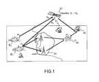
De nombreux systèmes de collecte de données sont aujourd'hui utilisés à des fins diverses : étude de la faune, de l'environnement, balise de détresse pour navire, système de surveillance du trafic maritime ...etc. Le système Argos, qui fonctionne depuis 1979, en est un exemple bien connu. Il existe cependant d'autres systèmes de collecte de données tels que le système AIS, Automatic Identification System selon l'acronyme anglais, ou le système SAR, Search And Rescue selon l'acronyme anglais, par exemple. Le principe de fonctionnement d'un système de collecte de données est représenté de manière générale sur la
Ainsi, sur ce schéma, des dispositifs de collecte de données équipent par exemple, une population animale, des bouées météorologiques, ou une flotte de bateaux de pêche. Les mesures effectuées par ces dispositifs sont encapsulées dans des signaux émis e1, e2, ..., par l'intermédiaire de dispositifs émetteurs adaptés E1, E2, ..., vers des satellites 20. Lesdits satellites 20 renvoient ces signaux, éventuellement modifiés, et éventuellement accompagnés de mesures sur le signal reçu S1, S2, ..., vers des stations de réception 30 au sol. Ces dernières font parvenir les signaux à des stations sol 40 qui présentent des moyens de traitement adaptés, permettant, par exemple, de localiser approximativement les objets d'une étude ou d'une surveillance. Après traitement des signaux transmis par les satellites 20 et les stations de réception 30, les stations sol 40 peuvent émettre des messages d'informations vers un réseau d'utilisateurs.Thus, on this diagram, data collection devices equip, for example, an animal population, weather buoys, or a fleet of fishing boats. The measurements made by these devices are encapsulated in emitted signals e1, e2,..., Via suitable transmitting devices E1, E2,..., Towards
Par ailleurs, une partie des signaux, ici e2, e3, e4, .., respectivement émis par les émetteurs E2, E3, E4, ..., peuvent être également reçus par des stations terrestres, comme c'est le cas dans l'AlS pour assurer la surveillance maritime en vue des côtes.Moreover, a part of the signals, here e2, e3, e4, .., respectively emitted by the emitters E2, E3, E4, ..., can also be received by earth stations, as is the case in the AlS to provide maritime surveillance for coastal areas.
L'ensemble des stations de réception 30 au sol recevant les signaux renvoyés par les satellites est désigné segment sol de mission satellite ; l'ensemble des stations côtières recevant directement les signaux émis par les émetteurs E1, E2, E3, E4, ..., est désigné réseau côtier ou terrestre 10. Les stations sol 40 sont reliées d'une part au segment sol de mission satellite et d'autre part au réseau terrestre 10.The set of ground receiving stations receiving the signals returned by the satellites is designated ground satellite mission segment; all the coast stations directly receiving the signals emitted by the emitters E1, E2, E3, E4,..., are designated coastal or
On va détailler le procédé de recouvrement du signal utile dans le cadre d'un système AlS par satellite.We will detail the method of recovery of the useful signal in the context of a satellite AlS system.
Le satellite 20 reçoit en même temps plusieurs signaux qui interfèrent entre eux pour former un signal composite S1+S2+S3+S4+.... Il y a parmi ces signaux, un signal dit utile et noté S1, les autres signaux S2, S3, S4, ... étant désignés signaux de collision. Ces signaux S1, S2, S3, S4, ... correspondent aux signaux e1, e2, e3, e4, ... respectivement émis par des émetteurs E1, E2, E3, E4,..., éventuellement mobiles.The
Par ailleurs une ou plusieurs stations côtières plus généralement désignées stations terrestres reçoivent directement les signaux e2, e3, e4, ... émis par les émetteurs E2, E3, E4, ... correspondant aux signaux de collision S2, S3, S4, ... reçus par le satellite ; ces signaux reçus par cette station côtière sont notés S2', S3', S4', ...., et notés S2", ... lorsqu'ils sont reçus par une autre station côtière. Le signal e1 émis par E1 n'est pas reçu par une station côtière en raison par exemple de son éloignement.Furthermore, one or more coast stations more generally referred to as terrestrial stations directly receive the signals e2, e3, e4,... Transmitted by the emitters E2, E3, E4,... Corresponding to the collision signals S2, S3, S4,. .. received by the satellite; these signals received by this coast station are denoted S2 ', S3', S4 ', ...., and denoted S2 ", ... when they are received by another coast station The signal e1 emitted by E1 n' is not received by a coast station because of for example its remoteness.
Le réseau terrestre 10 peut être soit le réseau terrestre côtier existant de l'AIS, soit un réseau terrestre à déployer placé plutôt en hauteur (montagne, colline) afin d'offrir une plus grande visibilité sur la zone maritime.The
Les signaux respectivement émis par les émetteurs E1 et E2 sont de la forme : ![]()
![]()
![]()
![]()
Ae étant l'amplitude, ωe la pulsation, ϕe la phase initiale et α la modulation du signal.A e being the amplitude, ω e the pulsation, φ e the initial phase and α the modulation of the signal.
Les pulsations ωe1 et ωe2 peuvent être différentes mais sont suffisamment proches pour générer des interférences perturbatrices.The pulsations ω e1 and ω e2 may be different but are close enough to generate disturbing interference.
A la réception par le satellite 20, ces signaux sont de la forme : ![]()
![]()
![]()
![]()
Le signal e2(t) émis par E2 est également reçu par une station côtière du réseau terrestre 10 : ce signal reçu S2'(t) est de la forme : ![]()
![]()
Le signal S2(t) reçu par le satellite est estimé (et noté S2) par une unité de traitement d'une station sol 40, à partir :
- du signal S2'(t) reçu par une station côtière du réseau terrestre 10,
- de la position de l'émetteur E2 à l'instant d'émission de son signal e2(t) et
- de la position du
satellite 20 lors de la réception du signal S2(t) fournie à partir de l'éphéméride du satellite.
- signal S2 '(t) received by a coast station of the
terrestrial network 10, - the position of the emitter E2 at the time of emission of its signal e 2 (t) and
- the position of the
satellite 20 when receiving the signal S2 (t) provided from the ephemeris of the satellite.
Pour reconstruire le signal S2 « tel qu'il a été vu par le satellite », on utilise en particulier une mesure de datation du signal S2' reçu au sol et l'information de position de l'émetteur. Dans le cas de l'AIS, ces deux tâches sont fortement facilitées par le fait qu'un système de positionnement (typiquement GPS) est associé à l'émetteur AIS, de sorte que l'émission des signaux est synchronisée sur le temps du système de positionnement et que le signal transmis contient la position de l'émetteur telle qu'estimée par ce système de positionnement.To reconstruct the signal S2 "as seen by the satellite", a signal dating S2 'received on the ground and the position information of the transmitter are used in particular. In the case of AIS, these two tasks are greatly facilitated by the fact that a positioning system (typically GPS) is associated with the AIS transmitter, so that the transmission of signals is synchronized with the system time. of positioning and that the transmitted signal contains the position of the transmitter as estimated by this positioning system.
On obtient : Ŝ2̂= Â2cos (ω̂)2 t + ϕ̂2 + α2 (t))We get: Ŝ2 = Â 2 cos (ω) 2 t + φ 2 + α 2 (t))
De même pour les autres signaux de collision S3, ... qui sont également estimés. On obtient donc aussi S3, ...Likewise for the other collision signals S3, ... which are also estimated. So we also get S3, ...
Puis on élimine ces signaux de collision estimés du signal composite reçu par le satellite en calculant : ![]()
![]()
On a ainsi recouvré le signal utile S1 reçu par le satellite 20.It has thus recovered the useful signal S1 received by the
Il n'est pas nécessaire de traiter, ou même de collecter l'ensemble des signaux de collision. Par exemple, si dans le cas à 3 signaux, on n'a collecté et estimé que le signal S2, on pourra appliquer l'invention en effectuant : ![]()
![]()
Le recouvrement de S1 parmi S1 +S3 pourra éventuellement se faire par d'autres méthodes, telles que des procédés de démodulation conjointe.The recovery of S1 among S1 + S3 may possibly be done by other methods, such as methods of joint demodulation.
Estimer le signal de collision S2 revient à déterminer :
- la pulsation de la porteuse ω2,
- la modulation α2 (t),
- la phase initiale ϕ2,
- la puissance, c'est-à-dire l'amplitude A2.
- the pulsation of the carrier ω 2 ,
- the modulation α 2 (t),
- the initial phase φ 2 ,
- the power, that is to say the amplitude A2.
On présente ici cette évaluation dans le cas de l'AIS par satellite.This assessment is presented here in the case of satellite AIS.
Pour permettre la démodulation du signal utile (non éliminé) avec une bonne performance, on considère qu'il faut que les signaux de collision soient éliminés avec un résidu inférieur à 20 dB sous le signal utile.To allow the demodulation of the useful signal (not eliminated) with a good performance, it is considered that the collision signals must be eliminated with a residual less than 20 dB below the useful signal.
On s'intéresse tout d'abord à la pulsation ω.We are interested first of all in the pulsation ω.
Il y a deux contributions à cette pulsation : le décalage de la fréquence centrale du navire, fixe dans le temps, dans un domaine de +/-500 Hz par rapport au centre de la bande, et la dérive Doppler. Sur l'émission e 2, la dérive Doppler peut être estimée d'après la vitesse et le cap du navire fournis dans le signal, et l'estimation de la fréquence centrale d'émission pourrait donc être faite en une seule mesure lors de la réception par la station terrestre. Aucune mesure de fréquence n'est cependant réalisée aujourd'hui dans le réseau terrestre côtier, et ces mesures devraient être remplacées par la création et la mise à jour par itérations d'une table des fréquences centrales de chaque navire. Pour la dérive Doppler due au satellite, en considérant le cas pire d'un navire (E2 ou E3) au nadir, avec une erreur de position de 20 m, on va obtenir une erreur sur le Doppler estimé à bord du satellite de 0.12Hz, soit sur l'ensemble du signal un décalage de phase de 0.014 rad, soit un résidu de ―37 dB ce qui est largement inférieur au seuil de -20 dB indiqué plus haut.There are two contributions to this pulsation: the shifting of the central frequency of the ship, fixed in time, in a range of +/- 500 Hz with respect to the center of the band, and the Doppler drift. On the e 2 emission , the Doppler drift can be estimated from the speed and heading of the ship provided in the signal, and the estimate of the central emission frequency could therefore be made in a single measurement at the same time. reception by the land station. However, no frequency measurement is currently performed in the coastal terrestrial network, and these measures should be replaced by the creation and iterative updating of a central frequency table for each vessel. For the Doppler drift due to the satellite, considering the worst case of a ship (E2 or E3) at nadir, with a position error of 20 m, we will obtain an error on the Doppler estimated onboard the satellite of 0.12 Hz , or over the entire signal a phase shift of 0.014 rad, or a residue of -37 dB which is well below the threshold of -20 dB indicated above.
La modulation α du signal de collision reçu par le satellite est la même que celle du signal de collision reçu par une station au sol.The modulation α of the collision signal received by the satellite is the same as that of the collision signal received by a ground station.
Concernant la synchronisation, on rappelle que les transmissions des signaux des navires se trouvant dans une même zone maritime sont effectuées selon un multiplexage basé sur l'attribution d'intervalles de temps (ou « slots » en anglais) TDMA. Pour avoir un résidu de phase initiale ϕ de ― 20 dB, il faut une erreur de synchronisation de 0.6% de la durée du bit, soit à 9600 bits/s une erreur de synchronisation de 0.66 µs. Comme les émissions des navires sont synchronisées sur le temps GPS (avec une précision de l'ordre de 50ns), le segment sol (les stations 30) n'a qu'à lever l'ambiguïté du slot d'émission. La seule source d'erreur est donc l'incertitude sur le temps de propagation entre le navire et le récepteur satellite, avec une tolérance de 200m. La précision du positionnement du navire est bien meilleure que ce seuil. En effet pour une erreur de positionnement de 20 m, le résidu de phase initiale est de ― 30 dB, ce qui est largement inférieur au seuil de -20 dB indiqué plus haut.Concerning the synchronization, it is recalled that the transmissions of the signals of the ships being in the same maritime area are carried out according to a multiplexing based on the allocation of time slots (or "slots" in English) TDMA. To have an initial phase residual φ of -20 dB, a synchronization error of 0.6% of the bit duration is required, ie at 9600 bits / s a synchronization error of 0.66 μs. Since ship emissions are synchronized with GPS time (with a precision of about 50ns), the ground segment (stations 30) only has to remove the ambiguity of the transmission slot. The only source of error is therefore the uncertainty on the propagation time between the ship and the satellite receiver, with a tolerance of 200m. The accuracy of the positioning of the ship is much better than this threshold. Indeed, for a positioning error of 20 m, the initial phase residue is -30 dB, which is well below the threshold of -20 dB indicated above.
L'amplitude A du signal peut-être estimée par un bilan de liaison, connaissant les caractéristiques antennaires de l'émetteur (navire) et du récepteur (satellite), ainsi que leur position au moment de l'émission et de la réception.The amplitude A of the signal can be estimated by a link budget, knowing the antennal characteristics of the transmitter (ship) and the receiver (satellite), as well as their position at the time of transmission and reception.
On a ainsi montré que le procédé selon l'invention permet d'éliminer les signaux de collision avec de bonnes performances.It has thus been shown that the method according to the invention makes it possible to eliminate the collision signals with good performances.
Ce procédé s'applique également à des signaux de type ARGOS, les émetteurs E1, E2, E3, ... étant alors généralement des balises ARGOS. Le signal émis par une balise contient également la position de la balise. Dans le cas d'Argos, les signaux ne sont pas émis de manière synchrone sur le système de positionnement, et il convient donc d'ajouter une mesure précise de la date d'arrivée dans la station côtière.This method also applies to signals of the ARGOS type, the emitters E1, E2, E3,... Being then generally ARGOS tags. The signal emitted by a beacon also contains the position of the beacon. In the case of Argos, the signals are not transmitted synchronously on the positioning system, and it is therefore appropriate to add a precise measurement of the arrival date in the coast station.
Dans le cas de signaux de téléphonie mobile par satellite, le procédé s'applique également. Mais la position de l'émetteur c'est-à-dire du téléphone mobile n'est pas incluse dans le signal émis. Elle peut alors être calculée par l'unité de traitement par triangulation à partir du signal de collision directement reçu par au moins deux stations terrestres : S2' et S2" sur la figure.In the case of mobile satellite signals, the method also applies. But the position of the transmitter that is to say the mobile phone is not included in the transmitted signal. It can then be calculated by the triangulation processing unit from the collision signal directly received by at least two earth stations: S2 'and S2 "in the figure.
Claims (9)
Applications Claiming Priority (1)
| Application Number | Priority Date | Filing Date | Title |
|---|---|---|---|
| FR1000702A FR2956745B1 (en) | 2010-02-19 | 2010-02-19 | METHOD FOR RECOVERING A SIGNAL AMONG A SET OF SIGNALS COLLECTED BY SATELLITE |
Publications (3)
| Publication Number | Publication Date |
|---|---|
| EP2362555A2 true EP2362555A2 (en) | 2011-08-31 |
| EP2362555A3 EP2362555A3 (en) | 2017-03-15 |
| EP2362555B1 EP2362555B1 (en) | 2017-12-20 |
Family
ID=43034359
Family Applications (1)
| Application Number | Title | Priority Date | Filing Date |
|---|---|---|---|
| EP11154788.1A Active EP2362555B1 (en) | 2010-02-19 | 2011-02-17 | Method for recovering a signal among a plurality of signals received by a satellite |
Country Status (5)
| Country | Link |
|---|---|
| US (1) | US8290484B2 (en) |
| EP (1) | EP2362555B1 (en) |
| CA (1) | CA2732178C (en) |
| DK (1) | DK2362555T3 (en) |
| FR (1) | FR2956745B1 (en) |
Cited By (1)
| Publication number | Priority date | Publication date | Assignee | Title |
|---|---|---|---|---|
| FR2997252A1 (en) * | 2012-10-23 | 2014-04-25 | Astrium Sas | METHOD AND SYSTEM FOR DETECTING BROADCAST SIGNALS ISSUED BY LAND SOURCES AND RECEIVED BY A SATELLITE |
Families Citing this family (9)
| Publication number | Priority date | Publication date | Assignee | Title |
|---|---|---|---|---|
| DE102012110384B4 (en) * | 2012-10-30 | 2019-11-28 | Deutsches Zentrum für Luft- und Raumfahrt e.V. | AIS monitoring system |
| DE102015112570B4 (en) * | 2014-08-06 | 2016-11-10 | Deutsches Zentrum für Luft- und Raumfahrt e.V. | Method for transmitting and receiving AIS radio signals |
| JP6445328B2 (en) * | 2015-01-07 | 2018-12-26 | 三菱スペース・ソフトウエア株式会社 | Signal detection system, program, and signal detection method |
| US9729374B2 (en) | 2015-08-07 | 2017-08-08 | Harris Corporation | Co-channel spatial separation using matched doppler filtering |
| US9491786B1 (en) * | 2015-09-24 | 2016-11-08 | Harris Corporation | Systems and methods for space-based digital selective calling |
| US9743264B2 (en) * | 2015-09-24 | 2017-08-22 | Harris Corporation | Systems and methods for space-based digital selective calling |
| US10054686B2 (en) | 2015-12-31 | 2018-08-21 | Spire Global, Inc. | System and method for remote satellite and ground station constellation management |
| US10165530B2 (en) * | 2016-03-22 | 2018-12-25 | Christoph RULAND | Verification of time information transmitted by time signals or time telegrams |
| JP7513920B2 (en) | 2020-12-24 | 2024-07-10 | 日本電信電話株式会社 | Wireless communication system, receiving device, control device, wireless communication method, control method, and program |
Family Cites Families (6)
| Publication number | Priority date | Publication date | Assignee | Title |
|---|---|---|---|---|
| US6473623B1 (en) * | 1996-04-18 | 2002-10-29 | At&T Wireless Services, Inc. | Method for self-calibration of a wireless communication system |
| US6603803B1 (en) * | 1999-03-12 | 2003-08-05 | Navcom Technology, Inc. | Global positioning system receiver for monitoring the satellite transmissions and for reducing the effects of multipath error on coded signals and carrier phase measurements |
| FR2820567B1 (en) * | 2001-02-08 | 2006-07-14 | Cit Alcatel | SATELLITE WITH TELEMETRY CONNECTION, MONITORING AND REMOTE CONTROL WITH DOUBLE MODULATION |
| US7890098B2 (en) * | 2001-09-14 | 2011-02-15 | Atc Technologies, Llc | Staggered sectorization for terrestrial reuse of satellite frequencies |
| US20090161797A1 (en) * | 2007-06-08 | 2009-06-25 | Cowles Philip R | Satellite detection of automatic identification system signals |
| FR2927748B1 (en) * | 2008-02-19 | 2015-10-16 | Thales Sa | METHOD OF PROCESSING A FIRST AND A SECOND SIGNAL OVERLOADED WITHIN A INCIDENT COMPOSITE SIGNAL, AND CORRESPONDING DEVICE |
-
2010
- 2010-02-19 FR FR1000702A patent/FR2956745B1/en not_active Expired - Fee Related
-
2011
- 2011-02-17 EP EP11154788.1A patent/EP2362555B1/en active Active
- 2011-02-17 US US13/029,946 patent/US8290484B2/en active Active
- 2011-02-17 DK DK11154788.1T patent/DK2362555T3/en active
- 2011-02-18 CA CA2732178A patent/CA2732178C/en not_active Expired - Fee Related
Non-Patent Citations (1)
| Title |
|---|
| None |
Cited By (3)
| Publication number | Priority date | Publication date | Assignee | Title |
|---|---|---|---|---|
| FR2997252A1 (en) * | 2012-10-23 | 2014-04-25 | Astrium Sas | METHOD AND SYSTEM FOR DETECTING BROADCAST SIGNALS ISSUED BY LAND SOURCES AND RECEIVED BY A SATELLITE |
| EP2725722A1 (en) * | 2012-10-23 | 2014-04-30 | Astrium Sas | Method and system for detecting broadcast signals transmitted by terrestrial sources and received by a satellite |
| US9331775B2 (en) | 2012-10-23 | 2016-05-03 | Airbus Defence And Space Sas | Method and system for detecting broadcast signals transmitted by terrestrial sources and received by a satellite |
Also Published As
| Publication number | Publication date |
|---|---|
| CA2732178A1 (en) | 2011-08-19 |
| US20110207398A1 (en) | 2011-08-25 |
| DK2362555T3 (en) | 2018-03-26 |
| CA2732178C (en) | 2018-03-06 |
| FR2956745B1 (en) | 2012-10-05 |
| EP2362555B1 (en) | 2017-12-20 |
| EP2362555A3 (en) | 2017-03-15 |
| FR2956745A1 (en) | 2011-08-26 |
| US8290484B2 (en) | 2012-10-16 |
Similar Documents
| Publication | Publication Date | Title |
|---|---|---|
| EP2362555B1 (en) | Method for recovering a signal among a plurality of signals received by a satellite | |
| EP1804071B1 (en) | Method for optimising positioning data processing where there are several satellite positioning constellations | |
| EP2407952B1 (en) | System for increasing the coverage, information and sturdiness of devices for automatic identification of ships | |
| EP2511729B1 (en) | Method for locating aircraft independently from any satellite navigation system | |
| EP2590341B1 (en) | Device on board of a satellite for receiving aircraft surveillance messages. | |
| EP3171195B1 (en) | Method for locating a beacon | |
| EP2587691B1 (en) | Method for the coordinated processing of signals transmitted by beacons | |
| EP1804399B1 (en) | Method for synchronising base stations of a terrestrial-cellular communication network | |
| EP2715392B1 (en) | Method for locating a terminal at the surface of a coverage zone by means of a telecommunication network using a multibeam satellite | |
| EP2366094B1 (en) | Method with pressure altitude correction for an aircraft | |
| EP0613021B1 (en) | Process, apparatus and transmitter for radiolocation utilising a multicarrier radio distribution system | |
| EP0938683B1 (en) | Satellite signal receiver with detector of incoherence between code phase and carrier frequency measurements | |
| EP2409424B1 (en) | Satellite payload with ais | |
| FR2943479A1 (en) | USEFUL CHARGE OF SAILING SATELLITE WITH AES NETWORK RECEIVING ANTENNA NETWORK, AIS SATELLITE SYSTEM AND AIS SIGNAL PROCESSING METHOD | |
| WO2009053402A1 (en) | Device and method making it possible to intercept communications in a network | |
| WO2020043905A1 (en) | Method of date-stamping telemetry signals | |
| EP2629439B1 (en) | Method for generating an emitting or receiving membrane of a satellite antenna | |
| FR3020686A1 (en) | FREQUENCY ESTIMATOR FOR AERONAUTICAL COMMUNICATION | |
| FR3027175A1 (en) | METHOD FOR PROVIDING DATA DATA PACKETS RECEIVED, DEVICE AND COMPUTER PROGRAM THEREFOR | |
| FR2902195A1 (en) | METHOD FOR DETERMINING THE INSTANT TIME OF A NON-IMPULSIVE RADIO ELECTRICAL SIGNAL AND GEOGRAPHIC LOCATION SYSTEM OF NON-IMPULSIVE RADIO ELECTRIC SIGNAL TRANSMITTERS | |
| WO2023002064A1 (en) | Device and method for centimetre-level positioning of a moving object | |
| FR2706659A1 (en) | Electronic anti-collision device for ships | |
| EP1946141A1 (en) | Method of determining the position of satellites in a navigation system |
Legal Events
| Date | Code | Title | Description |
|---|---|---|---|
| PUAI | Public reference made under article 153(3) epc to a published international application that has entered the european phase |
Free format text: ORIGINAL CODE: 0009012 |
|
| AK | Designated contracting states |
Kind code of ref document: A2 Designated state(s): AL AT BE BG CH CY CZ DE DK EE ES FI FR GB GR HR HU IE IS IT LI LT LU LV MC MK MT NL NO PL PT RO RS SE SI SK SM TR |
|
| AX | Request for extension of the european patent |
Extension state: BA ME |
|
| PUAL | Search report despatched |
Free format text: ORIGINAL CODE: 0009013 |
|
| AK | Designated contracting states |
Kind code of ref document: A3 Designated state(s): AL AT BE BG CH CY CZ DE DK EE ES FI FR GB GR HR HU IE IS IT LI LT LU LV MC MK MT NL NO PL PT RO RS SE SI SK SM TR |
|
| AX | Request for extension of the european patent |
Extension state: BA ME |
|
| RIC1 | Information provided on ipc code assigned before grant |
Ipc: H04B 1/12 20060101ALI20170209BHEP Ipc: H04B 7/185 20060101AFI20170209BHEP |
|
| 17P | Request for examination filed |
Effective date: 20170331 |
|
| RBV | Designated contracting states (corrected) |
Designated state(s): AL AT BE BG CH CY CZ DE DK EE ES FI FR GB GR HR HU IE IS IT LI LT LU LV MC MK MT NL NO PL PT RO RS SE SI SK SM TR |
|
| GRAP | Despatch of communication of intention to grant a patent |
Free format text: ORIGINAL CODE: EPIDOSNIGR1 |
|
| INTG | Intention to grant announced |
Effective date: 20170804 |
|
| RAP1 | Party data changed (applicant data changed or rights of an application transferred) |
Owner name: THALES |
|
| GRAS | Grant fee paid |
Free format text: ORIGINAL CODE: EPIDOSNIGR3 |
|
| GRAA | (expected) grant |
Free format text: ORIGINAL CODE: 0009210 |
|
| AK | Designated contracting states |
Kind code of ref document: B1 Designated state(s): AL AT BE BG CH CY CZ DE DK EE ES FI FR GB GR HR HU IE IS IT LI LT LU LV MC MK MT NL NO PL PT RO RS SE SI SK SM TR |
|
| REG | Reference to a national code |
Ref country code: GB Ref legal event code: FG4D Free format text: NOT ENGLISH |
|
| REG | Reference to a national code |
Ref country code: CH Ref legal event code: EP |
|
| REG | Reference to a national code |
Ref country code: IE Ref legal event code: FG4D Free format text: LANGUAGE OF EP DOCUMENT: FRENCH |
|
| REG | Reference to a national code |
Ref country code: AT Ref legal event code: REF Ref document number: 957268 Country of ref document: AT Kind code of ref document: T Effective date: 20180115 |
|
| REG | Reference to a national code |
Ref country code: DE Ref legal event code: R096 Ref document number: 602011044291 Country of ref document: DE |
|
| REG | Reference to a national code |
Ref country code: FR Ref legal event code: PLFP Year of fee payment: 8 |
|
| REG | Reference to a national code |
Ref country code: DK Ref legal event code: T3 Effective date: 20180321 |
|
| REG | Reference to a national code |
Ref country code: NL Ref legal event code: FP |
|
| PG25 | Lapsed in a contracting state [announced via postgrant information from national office to epo] |
Ref country code: FI Free format text: LAPSE BECAUSE OF FAILURE TO SUBMIT A TRANSLATION OF THE DESCRIPTION OR TO PAY THE FEE WITHIN THE PRESCRIBED TIME-LIMIT Effective date: 20171220 Ref country code: SE Free format text: LAPSE BECAUSE OF FAILURE TO SUBMIT A TRANSLATION OF THE DESCRIPTION OR TO PAY THE FEE WITHIN THE PRESCRIBED TIME-LIMIT Effective date: 20171220 Ref country code: NO Free format text: LAPSE BECAUSE OF FAILURE TO SUBMIT A TRANSLATION OF THE DESCRIPTION OR TO PAY THE FEE WITHIN THE PRESCRIBED TIME-LIMIT Effective date: 20180320 Ref country code: LT Free format text: LAPSE BECAUSE OF FAILURE TO SUBMIT A TRANSLATION OF THE DESCRIPTION OR TO PAY THE FEE WITHIN THE PRESCRIBED TIME-LIMIT Effective date: 20171220 |
|
| REG | Reference to a national code |
Ref country code: LT Ref legal event code: MG4D |
|
| REG | Reference to a national code |
Ref country code: AT Ref legal event code: MK05 Ref document number: 957268 Country of ref document: AT Kind code of ref document: T Effective date: 20171220 |
|
| PG25 | Lapsed in a contracting state [announced via postgrant information from national office to epo] |
Ref country code: GR Free format text: LAPSE BECAUSE OF FAILURE TO SUBMIT A TRANSLATION OF THE DESCRIPTION OR TO PAY THE FEE WITHIN THE PRESCRIBED TIME-LIMIT Effective date: 20180321 Ref country code: HR Free format text: LAPSE BECAUSE OF FAILURE TO SUBMIT A TRANSLATION OF THE DESCRIPTION OR TO PAY THE FEE WITHIN THE PRESCRIBED TIME-LIMIT Effective date: 20171220 Ref country code: BG Free format text: LAPSE BECAUSE OF FAILURE TO SUBMIT A TRANSLATION OF THE DESCRIPTION OR TO PAY THE FEE WITHIN THE PRESCRIBED TIME-LIMIT Effective date: 20180320 Ref country code: LV Free format text: LAPSE BECAUSE OF FAILURE TO SUBMIT A TRANSLATION OF THE DESCRIPTION OR TO PAY THE FEE WITHIN THE PRESCRIBED TIME-LIMIT Effective date: 20171220 Ref country code: RS Free format text: LAPSE BECAUSE OF FAILURE TO SUBMIT A TRANSLATION OF THE DESCRIPTION OR TO PAY THE FEE WITHIN THE PRESCRIBED TIME-LIMIT Effective date: 20171220 |
|
| PG25 | Lapsed in a contracting state [announced via postgrant information from national office to epo] |
Ref country code: CZ Free format text: LAPSE BECAUSE OF FAILURE TO SUBMIT A TRANSLATION OF THE DESCRIPTION OR TO PAY THE FEE WITHIN THE PRESCRIBED TIME-LIMIT Effective date: 20171220 Ref country code: ES Free format text: LAPSE BECAUSE OF FAILURE TO SUBMIT A TRANSLATION OF THE DESCRIPTION OR TO PAY THE FEE WITHIN THE PRESCRIBED TIME-LIMIT Effective date: 20171220 Ref country code: CY Free format text: LAPSE BECAUSE OF FAILURE TO SUBMIT A TRANSLATION OF THE DESCRIPTION OR TO PAY THE FEE WITHIN THE PRESCRIBED TIME-LIMIT Effective date: 20171220 Ref country code: EE Free format text: LAPSE BECAUSE OF FAILURE TO SUBMIT A TRANSLATION OF THE DESCRIPTION OR TO PAY THE FEE WITHIN THE PRESCRIBED TIME-LIMIT Effective date: 20171220 Ref country code: SK Free format text: LAPSE BECAUSE OF FAILURE TO SUBMIT A TRANSLATION OF THE DESCRIPTION OR TO PAY THE FEE WITHIN THE PRESCRIBED TIME-LIMIT Effective date: 20171220 |
|
| PG25 | Lapsed in a contracting state [announced via postgrant information from national office to epo] |
Ref country code: IT Free format text: LAPSE BECAUSE OF FAILURE TO SUBMIT A TRANSLATION OF THE DESCRIPTION OR TO PAY THE FEE WITHIN THE PRESCRIBED TIME-LIMIT Effective date: 20171220 Ref country code: RO Free format text: LAPSE BECAUSE OF FAILURE TO SUBMIT A TRANSLATION OF THE DESCRIPTION OR TO PAY THE FEE WITHIN THE PRESCRIBED TIME-LIMIT Effective date: 20171220 Ref country code: IS Free format text: LAPSE BECAUSE OF FAILURE TO SUBMIT A TRANSLATION OF THE DESCRIPTION OR TO PAY THE FEE WITHIN THE PRESCRIBED TIME-LIMIT Effective date: 20180420 Ref country code: PL Free format text: LAPSE BECAUSE OF FAILURE TO SUBMIT A TRANSLATION OF THE DESCRIPTION OR TO PAY THE FEE WITHIN THE PRESCRIBED TIME-LIMIT Effective date: 20171220 Ref country code: SM Free format text: LAPSE BECAUSE OF FAILURE TO SUBMIT A TRANSLATION OF THE DESCRIPTION OR TO PAY THE FEE WITHIN THE PRESCRIBED TIME-LIMIT Effective date: 20171220 Ref country code: AT Free format text: LAPSE BECAUSE OF FAILURE TO SUBMIT A TRANSLATION OF THE DESCRIPTION OR TO PAY THE FEE WITHIN THE PRESCRIBED TIME-LIMIT Effective date: 20171220 |
|
| REG | Reference to a national code |
Ref country code: DE Ref legal event code: R119 Ref document number: 602011044291 Country of ref document: DE |
|
| REG | Reference to a national code |
Ref country code: CH Ref legal event code: PL |
|
| PG25 | Lapsed in a contracting state [announced via postgrant information from national office to epo] |
Ref country code: MT Free format text: LAPSE BECAUSE OF FAILURE TO SUBMIT A TRANSLATION OF THE DESCRIPTION OR TO PAY THE FEE WITHIN THE PRESCRIBED TIME-LIMIT Effective date: 20171220 Ref country code: MC Free format text: LAPSE BECAUSE OF FAILURE TO SUBMIT A TRANSLATION OF THE DESCRIPTION OR TO PAY THE FEE WITHIN THE PRESCRIBED TIME-LIMIT Effective date: 20171220 |
|
| PLBE | No opposition filed within time limit |
Free format text: ORIGINAL CODE: 0009261 |
|
| STAA | Information on the status of an ep patent application or granted ep patent |
Free format text: STATUS: NO OPPOSITION FILED WITHIN TIME LIMIT |
|
| 26N | No opposition filed |
Effective date: 20180921 |
|
| REG | Reference to a national code |
Ref country code: IE Ref legal event code: MM4A |
|
| REG | Reference to a national code |
Ref country code: BE Ref legal event code: MM Effective date: 20180228 |
|
| PG25 | Lapsed in a contracting state [announced via postgrant information from national office to epo] |
Ref country code: LI Free format text: LAPSE BECAUSE OF NON-PAYMENT OF DUE FEES Effective date: 20180228 Ref country code: CH Free format text: LAPSE BECAUSE OF NON-PAYMENT OF DUE FEES Effective date: 20180228 |
|
| PG25 | Lapsed in a contracting state [announced via postgrant information from national office to epo] |
Ref country code: DE Free format text: LAPSE BECAUSE OF NON-PAYMENT OF DUE FEES Effective date: 20180901 Ref country code: IE Free format text: LAPSE BECAUSE OF NON-PAYMENT OF DUE FEES Effective date: 20180217 |
|
| PG25 | Lapsed in a contracting state [announced via postgrant information from national office to epo] |
Ref country code: BE Free format text: LAPSE BECAUSE OF NON-PAYMENT OF DUE FEES Effective date: 20180228 Ref country code: SI Free format text: LAPSE BECAUSE OF FAILURE TO SUBMIT A TRANSLATION OF THE DESCRIPTION OR TO PAY THE FEE WITHIN THE PRESCRIBED TIME-LIMIT Effective date: 20171220 |
|
| PG25 | Lapsed in a contracting state [announced via postgrant information from national office to epo] |
Ref country code: TR Free format text: LAPSE BECAUSE OF FAILURE TO SUBMIT A TRANSLATION OF THE DESCRIPTION OR TO PAY THE FEE WITHIN THE PRESCRIBED TIME-LIMIT Effective date: 20171220 |
|
| PG25 | Lapsed in a contracting state [announced via postgrant information from national office to epo] |
Ref country code: HU Free format text: LAPSE BECAUSE OF FAILURE TO SUBMIT A TRANSLATION OF THE DESCRIPTION OR TO PAY THE FEE WITHIN THE PRESCRIBED TIME-LIMIT; INVALID AB INITIO Effective date: 20110217 Ref country code: PT Free format text: LAPSE BECAUSE OF FAILURE TO SUBMIT A TRANSLATION OF THE DESCRIPTION OR TO PAY THE FEE WITHIN THE PRESCRIBED TIME-LIMIT Effective date: 20171220 |
|
| PG25 | Lapsed in a contracting state [announced via postgrant information from national office to epo] |
Ref country code: MK Free format text: LAPSE BECAUSE OF NON-PAYMENT OF DUE FEES Effective date: 20171220 |
|
| PG25 | Lapsed in a contracting state [announced via postgrant information from national office to epo] |
Ref country code: AL Free format text: LAPSE BECAUSE OF FAILURE TO SUBMIT A TRANSLATION OF THE DESCRIPTION OR TO PAY THE FEE WITHIN THE PRESCRIBED TIME-LIMIT Effective date: 20171220 |
|
| PGFP | Annual fee paid to national office [announced via postgrant information from national office to epo] |
Ref country code: NL Payment date: 20240129 Year of fee payment: 14 |
|
| PGFP | Annual fee paid to national office [announced via postgrant information from national office to epo] |
Ref country code: LU Payment date: 20240213 Year of fee payment: 14 |
|
| PGFP | Annual fee paid to national office [announced via postgrant information from national office to epo] |
Ref country code: GB Payment date: 20240118 Year of fee payment: 14 |
|
| PGFP | Annual fee paid to national office [announced via postgrant information from national office to epo] |
Ref country code: FR Payment date: 20240123 Year of fee payment: 14 Ref country code: DK Payment date: 20240214 Year of fee payment: 14 |