EP2317348A1 - Method for building a depositional space corresponding to a geological domain - Google Patents
Method for building a depositional space corresponding to a geological domain Download PDFInfo
- Publication number
- EP2317348A1 EP2317348A1 EP09306043A EP09306043A EP2317348A1 EP 2317348 A1 EP2317348 A1 EP 2317348A1 EP 09306043 A EP09306043 A EP 09306043A EP 09306043 A EP09306043 A EP 09306043A EP 2317348 A1 EP2317348 A1 EP 2317348A1
- Authority
- EP
- European Patent Office
- Prior art keywords
- geological domain
- depositional
- mesh
- geological
- nodes
- Prior art date
- Legal status (The legal status is an assumption and is not a legal conclusion. Google has not performed a legal analysis and makes no representation as to the accuracy of the status listed.)
- Granted
Links
- 238000000034 method Methods 0.000 title claims abstract description 114
- 238000006073 displacement reaction Methods 0.000 claims abstract description 47
- 238000004088 simulation Methods 0.000 claims abstract description 34
- 238000004364 calculation method Methods 0.000 claims abstract description 13
- 239000011343 solid material Substances 0.000 claims abstract description 12
- 238000000638 solvent extraction Methods 0.000 claims abstract description 5
- 238000004590 computer program Methods 0.000 claims abstract description 3
- 239000000463 material Substances 0.000 claims description 16
- 238000009472 formulation Methods 0.000 claims description 9
- 239000000203 mixture Substances 0.000 claims description 9
- 230000005489 elastic deformation Effects 0.000 claims description 8
- 239000011159 matrix material Substances 0.000 claims description 6
- 239000011435 rock Substances 0.000 description 16
- 230000006870 function Effects 0.000 description 13
- 238000004422 calculation algorithm Methods 0.000 description 9
- 230000008021 deposition Effects 0.000 description 9
- 230000000704 physical effect Effects 0.000 description 7
- 238000012546 transfer Methods 0.000 description 7
- 230000006399 behavior Effects 0.000 description 6
- 239000013598 vector Substances 0.000 description 6
- 239000007787 solid Substances 0.000 description 5
- 230000000694 effects Effects 0.000 description 3
- 230000035515 penetration Effects 0.000 description 3
- 238000012805 post-processing Methods 0.000 description 3
- 239000013049 sediment Substances 0.000 description 3
- 230000009466 transformation Effects 0.000 description 3
- 238000000844 transformation Methods 0.000 description 3
- 230000008901 benefit Effects 0.000 description 2
- 230000008859 change Effects 0.000 description 2
- 239000003795 chemical substances by application Substances 0.000 description 2
- 230000003628 erosive effect Effects 0.000 description 2
- 229940054107 isochron Drugs 0.000 description 2
- MOYKHGMNXAOIAT-JGWLITMVSA-N isosorbide dinitrate Chemical compound [O-][N+](=O)O[C@H]1CO[C@@H]2[C@H](O[N+](=O)[O-])CO[C@@H]21 MOYKHGMNXAOIAT-JGWLITMVSA-N 0.000 description 2
- 238000013507 mapping Methods 0.000 description 2
- 238000012986 modification Methods 0.000 description 2
- 230000004048 modification Effects 0.000 description 2
- 230000035699 permeability Effects 0.000 description 2
- 239000011148 porous material Substances 0.000 description 2
- 230000008569 process Effects 0.000 description 2
- 108050005509 3D domains Proteins 0.000 description 1
- 230000005483 Hooke's law Effects 0.000 description 1
- 238000013459 approach Methods 0.000 description 1
- 230000001419 dependent effect Effects 0.000 description 1
- 238000009826 distribution Methods 0.000 description 1
- 238000005259 measurement Methods 0.000 description 1
- 230000005405 multipole Effects 0.000 description 1
- 238000010422 painting Methods 0.000 description 1
- 239000002245 particle Substances 0.000 description 1
- 238000005192 partition Methods 0.000 description 1
- 238000012552 review Methods 0.000 description 1
- 238000010008 shearing Methods 0.000 description 1
- 238000012360 testing method Methods 0.000 description 1
Images


Classifications
-
- G—PHYSICS
- G01—MEASURING; TESTING
- G01V—GEOPHYSICS; GRAVITATIONAL MEASUREMENTS; DETECTING MASSES OR OBJECTS; TAGS
- G01V11/00—Prospecting or detecting by methods combining techniques covered by two or more of main groups G01V1/00 - G01V9/00
-
- G—PHYSICS
- G01—MEASURING; TESTING
- G01V—GEOPHYSICS; GRAVITATIONAL MEASUREMENTS; DETECTING MASSES OR OBJECTS; TAGS
- G01V1/00—Seismology; Seismic or acoustic prospecting or detecting
- G01V1/28—Processing seismic data, e.g. analysis, for interpretation, for correction
-
- G—PHYSICS
- G06—COMPUTING; CALCULATING OR COUNTING
- G06T—IMAGE DATA PROCESSING OR GENERATION, IN GENERAL
- G06T17/00—Three dimensional [3D] modelling, e.g. data description of 3D objects
- G06T17/20—Finite element generation, e.g. wire-frame surface description, tesselation
-
- G—PHYSICS
- G09—EDUCATION; CRYPTOGRAPHY; DISPLAY; ADVERTISING; SEALS
- G09B—EDUCATIONAL OR DEMONSTRATION APPLIANCES; APPLIANCES FOR TEACHING, OR COMMUNICATING WITH, THE BLIND, DEAF OR MUTE; MODELS; PLANETARIA; GLOBES; MAPS; DIAGRAMS
- G09B23/00—Models for scientific, medical, or mathematical purposes, e.g. full-sized devices for demonstration purposes
- G09B23/40—Models for scientific, medical, or mathematical purposes, e.g. full-sized devices for demonstration purposes for geology
Definitions
- the general field of the invention is, not limited to, the modeling of stratified terrains in the subsurface, in oil reservoir geosciences notably.
- the invention pertains to a method for building a virtual and physically-reliable depositional space matching the chronostratigraphic environment at the time of deposition of geological terrains, said depositional space being then used as a computational space where many applications can be run advantageously.
- Such applications include accurate modeling and interpolation of geological terrains properties such as porosity or permeability, controlling the quality of seismic reflection data interpretation, or building grids fitting the complex geometry of geological structures.
- the physical properties of a 3D geological domain such as porosity or permeability are usually modeled using geostatistical methods. These methods interpolate the ground properties inside a 3D high-resolution mesh on the basis of a usually sparse data, such as measurements obtained from wells. This interpolation process makes an intensive use of distances, such as Euclidean distances between the centers of mesh elements, or of correlation distances given by variograms.
- the computed distributions of physical properties must reflect the paleo-environment at the time of deposition of the terrains, so the interpolation between the data obtained from the wells is accurate only if the computed Euclidean distances are close to the equivalent distances at the time of deposition (which are referred to as the "geodesic distances").
- an “isochron” refers to a surface joining points of the present-day space where sediments deposited at the same time. Seismic horizons or the top of geological layers that do not represent a gap in the geologic record are typically isochrons. Boundaries of sequences corresponding to stratigraphic unconformities are not isochrons. "Gaps” refer to situations where points of the depositional space have no corresponding location in the present-day space, and “overlaps” refer to situations where points of the depositional space have more than one corresponding location in the present-day space.
- a first type of solutions can be referred to as "( i, j, k ) indexation” solutions, as they consist in building a 3D structured conformal mesh in the present-day space with a Cartesian coordinate system ( x, y, z ), which represents the present-day geometry of the geological domain.
- This mesh is structured, so an ( i, j, k ) index can be assigned to every node and element of the mesh. This indexation is such that the neighbors of a node or an element can be found by simple transformations of its index, these transformations being the same for all the nodes and elements of the mesh.
- transformations are ( i -1, j , k ), ( i , j -1, k ), ( i , j , k -1), ( i +1, j , k ), ( i , j +1, k ) and ( i , j , k +1).
- u, v, w curvilinear coordinate system
- a second type of solutions can be referred to as "parametric" solutions, as they consist in computing depositional coordinates with an interpolation of some quantities following a set of geometric rules.
- the interpolation of the w(x, y, z) transfer function is done so that specific iso-values (iso-surfaces) of the function approximate the geometry of the horizons, which guarantees the property "P1" to be honored.
- the two other transfer functions u(x, y, z) and v(x, y, z) are computed.
- the interpolation of these transfer functions is done so that their gradients are orthogonal both to each other and to the gradient of the w(x, y, z) transfer function previously computed, and so that the length of their gradients are equal.
- WO 2005/119304 discloses running the interpolation on a tetrahedral mesh (a mesh whose elements are all tetrahedra).
- slip vectors should be used as boundary conditions, such arbitrary choices can produce a significant distortion when mapping points from one space to another, and as a result the geometry of the geological domain in the depositional space may not be close to its geometry at the time of deposition.
- distances measured in the depositional space should be scaled by the distortion to match the geodesic distances.
- This distortion can be locally very high and reduces the accuracy of the property modeling. For example, it can dramatically alter the computed pore volume of the rocks, and thus the amount of oil and gas in these rocks.
- the purpose of the invention is to propose a method for physically computing a curvilinear coordinate system (u, v, w) defining a depositional space.
- the invention proposes a method for building a depositional space corresponding to a geological I domain, comprising the steps of:
- the depositional space as computed by the method according to the invention may advantageously be defined (without any intention to be limitative) so that it honors the two following properties (referred to as the "P1" and "P2" properties):
- the solid material mechanical behavior can be any behavior, such as an elastic behavior, a plastic behavior, a behavior involving the viscosity for instance, or any combination of behaviors.
- the calculation of the depositional coordinates ( u, v, w ) can include:
- the invention makes possible the computation of a depositional coordinate system ( u, v, w ), advantageously honoring the "P1" and "P2" properties, where the geometry of the 3D geological domain is physically reliable, thereby allowing the definition of a low-distorted computational space where measured Euclidean distances are close to geodesic distances.
- geostatistical interpolations or simulation algorithms can advantageously model the physical properties of the 3D geological domain with an improved accuracy.
- the generation of meshes honoring the complex geometries of geological structures can also be made much easier when performed in that depositional space.
- the quality of a 3D seismic reflection interpretation can be more precisely checked if run in that depositional space.
- horizon is used in a very general sense, referring to a specific isochron identified within a sequence of the geological domain, without representing a gap in the geologic record.
- horizons may be planar and parallel ("P1" property). As a consequence, layers may not be faulted in the depositional space.
- the present invention does not simplify the processed geological model. All the faults are taken into account, whatever the connections between them. Faults can have free borders and do not need to be artificially extended so that to be entirely connected with other boundaries of the model.
- the present invention is also not limited to a particular tectonic context. For example, extensional structures or compressive structures are handled exactly the same way. So the present invention can advantageously handle the full complexity of geological models.
- the mechanical simulation setup step can further comprise the definition of a boundary condition prescribing that the nodes matching a given horizon of the geological domain have substantially the same final w(x, y, z) value,
- the mechanical simulation setup step can further comprise the definition of:
- the invention further provides a method wherein the field of displacements ( dx, dy, dz ) is calculated using a Finite Element Method (FEM), the (present-day) geometry of the geological domain being represented by at least one 3D conformal mesh, the elements of said 3D conformal mesh being polyhedra.
- FEM Finite Element Method
- the method according to the "FEM” embodiment can further comprise the computation at location ( x, y, z ) in the geological domain of the value of a terrain property calculated (that is for instance simulated by a geostatistical method performed in the depositional space) at location ( u, v, w ) in the depositional space, said terrain property computation comprising the following steps:
- the invention provides a method wherein the field of displacements ( dx, dy, dz ) is calculated using a Boundary Element Method (BEM), the (present-day) geometry of the geological domain being represented by a set of 2D conformal meshes embedded in 3D, each of these meshes representing a boundary of said geological domain, the elements of said 2D meshes being polygons.
- BEM Boundary Element Method
- the method according to the "BEM” embodiment can further comprise the computation of the value at location ( x, y, z ) of a terrain property calculated (that is for instance simulated by a geostatistical method performed in the depositional space) at location ( u, v, w ) in the depositional space, said terrain property computation comprising the following steps:
- the method according to the invention comprises the following steps:
- the present time geological domain 1 of Figures 1 and 2 are cross-section views at constant y , so only x and z coordinates are shown.
- the representation in the depositional space of Figure 3 is a cross-section view at constant v , so only u and w coordinates are shown.
- the method of the invention allows defining a depositional space 2 fitted with a depositional coordinate system (u, v, w) honoring both properties "P1" and "P2", where the geometry of the 3D geological domain is physically reliable, thereby allowing the definition of a low-distorted computational space where measured Euclidean distances 20 are close to geodesic distances 21.
- geostatistical interpolations or simulation algorithms can advantageously model the physical properties of the 3D geological domain with an improved accuracy.
- the generation of meshes honoring the complex geometries of geological structures can also be made much easier when performed in that depositional space.
- the quality of a 3D seismic reflection interpretation can be more precisely checked if run in that depositional space.
- boundary matching step There are potentially many possible implementation methods for the boundary matching step, depending on the algorithms and the data structures it uses. Usually, the more complex a data structure, the simpler the algorithm will be, although the simplicity of the algorithm is altered by the data structure update management. On the other hand, a simple data structure is efficient to update but forces the algorithm to perform explicitly a set of operations to recreate some data needed each time. As a consequence, the final choice is often a compromise.
- the geological IDs associated with the boundaries of the geological domain 1, B ⁇ B1, B2, B3, ... , Bn ⁇ , where B is the restricted set of boundaries 4 involved in the further steps of the method, can be represented by a series of n arbitrary integer numbers ⁇ b1 , b2 , b3 , ..., bn ⁇ .
- B may be represented by a linear list of n records, that is a set of n records whose structural properties essentially involve only the relative position of the records. Record positions can be put into a one-to-one correspondence with the set of the first n integers, so that the geological ID bi , associated with the ith record of the list B , may be equal to i.
- the geological domain can be represented by a 3D conformal mesh 9 whose elements 11 are all tetrahedra.
- the generation of the mesh is not within the scope of the invention and can be done following any classical method known in the art.
- Each tetrahedron has four facets 12, and each of these four facets can be simply identified with an index between 1 and 4. Facets in the tetrahedral mesh may thus be represented unambiguously by a pair ( T, J ) where T is a tetrahedron and J an index between 1 and 4.
- the method assumes that the tetrahedral mesh is conformal, so there is at least one facet that matches each of the boundaries 4 contained in the set B .
- the values of aj may be set during an initialization step taking place at the beginning of the boundary matching step. Then, retrieving all the facets of the tetrahedral mesh that correspond to a given boundary Bi of the geological domain may involve the following steps:
- the list of facets Fi may be further split into two lists Fi+ and Fi- .
- the list Fi+ contains all the facets of Fi having a normal vector that locally matches (in the most general sense) the normal vector of the boundary Bi , the normal vector of a facet ( T , I ) being for example defined as the normal vector to the plane defined by the three nodes of the facet pointing towards the exterior of T .
- the list Fi - contains all the other facets of Fi . These two lists may be used to retrieve all the facets that correspond to a given side (" + " or "-") of a given boundary of the geological domain.
- the unknown displacements ( dx, dy, dz ) can be advantageously determined using a Finite Element Method (FEM).
- FEM Finite Element Method
- the FEM method is a classical numerical method, well known from the one skilled in the art, so it will be only partially described here in order not to obscure embodiments of the invention. A detailed description can be for instance found in the book by Zienkiewicz and Taylor, "The Finite Element Method - Volume 1: The Basis", Butterworth-Heinemann editions (2000 ).
- every element 11 of the 3D conformal mesh 9 is associated with at least two parameters representing the mechanical properties of the material contained in the portion of the geological domain corresponding to the inside of that element.
- the number of parameters depends on the solid material deformation model implemented. An elastic deformation model requires two parameters, while plastic or more advanced deformation models require more parameters.
- the values of the parameters can differ from element 11 to element 11 through the mesh 9 and also change with time during the mechanical simulation step.
- these parameters are usually the Poisson's ratio and the Young's modulus (or the corresponding Lamé coefficients) relative to the material contained in the mesh element.
- a boundary condition is set to prescribe that all the nodes 10 of the facets 12 corresponding to a given horizon 5 of the geological domain 1 have the same final w ( x, y, z ) value, so as to appear as a plane in the depositional space as shown in figure 5(c) . That value can be left as an output of the mechanical simulation step, or can be explicitly specified.
- another boundary condition is set to prescribe that all the nodes 10 of the facets 12 corresponding to a given side of a given fault 7 or horizon 5 of the geological domain 1 are free to move provided that they stay in contact with the facets corresponding to the other side of the fault 7 or horizon 5.
- another boundary condition may be set to prescribe that all the nodes 10 located at the intersection between a given horizon 5 of the geological domain 1 and a given side of a given fault 7 of the geological domain 1 are free to move provided that they stay in contact with the edges corresponding to the intersection between the horizon 5 and the other side of the fault 7.
- Figure 5(d) shows an example of how a fault 7 appears in the depositional space, with the two sides having stayed mechanically in contact without interpenetrations, but free so slide.
- each sequence 8 identified in the geological domain 1 can be processed separately, leading to a representation of its own depositional space 2, as shown on Figure 3 .
- the FEM computation can be done by building a global stiffness matrix as done in any classical implicit Finite Element Method known in the art.
- the FEM computation can be done iteratively by building and updating local stiffness matrices defined at the nodes 10 of the 3D mesh 9 representing the present-day geometry of the geological domain 1, allowing forces to be transmitted from node to node (or from a set of nodes to other sets of nodes) until equilibrium is obtained as done in any "dynamic relaxation", “multi-agent”, Block Gauss-Seidel or Block Jacobi method known in the art. Such methods are described for instance in the book by Saad, "Iterative Methods for Sparse Linear Systems", Siam editions (2003 ).
- the FEM computation is not limited to the small displacement hypothesis and can handle large deformations, avoiding in that case the undesirable side effects of rotations.
- a "master/slave" formulation is used. That formulation can be for instance based on a classical penalty method or on the use of Lagrange multipliers.
- the unknown displacement field d is searched in the kinematic admissible displacement field D .
- V the space V of "test" admissible virtual displacement field v.
- ⁇ g 1 , ..., g n ⁇ and ⁇ ⁇ 1 , ..., ⁇ n ⁇ are the basis of given shape functions approximating displacements and Lagrange multipliers respectively.
- the resulting non-linear system can be solved iteratively in order to nullify the first order residual at step ( n +1) according that R(dh, ⁇ h ) is not null at step n .
- This matrix system can be directly inversed in two dimensions with a LU factorization, or solved iteratively in three dimensions with an Uzawa or Minimal Residual Fashion algorithm (see for example Saad, "Iterative Methods for Sparse Linear Systems", Siam editions (2003 )).
- the solved nodal displacements ( dx, dy, dz ) are used to define the depositional coordinate system ( u, v, w ) at the location of each node 10 used in the 3D conformal mesh 9.
- a point P with Cartesian coordinates ( x, y, z ) in the present-day geological domain 1 is attributed ( u, v, w ) coordinates in the depositional space 2.
- the geological domain 1 can be represented by a set M of 2D independent meshes (for example made of triangles 12), each of these meshes representing a boundary 4 of the set B .
- the generation of the 2D meshes is not within the scope of the invention and can be done following any classical method known in the art.
- the data structure representing such a triangular mesh Mj is encoded so that memory slots are reserved to store and retrieve an integer value A ( Mj ).
- a ( Mj ) is set so that if the mesh Mj represents the boundary Bi, then A ( Mj ) is equal to the corresponding geological ID bi (equal to i for example).
- the value of the A ( Mj ) may be set during an initialization step taking place at the beginning of the boundary matching step. Then, retrieving all the triangles that correspond to a given boundary Bi of the geological domain may involve the following steps:
- the unknown displacements ( dx, dy, dz ) are advantageously determined using a Boundary Element Method (BEM).
- BEM Boundary Element Method
- the BEM method is a classical numerical method, well known from the one skilled in the art, so it will be only partially described here in order not to obscure embodiments of the invention. A detailed description can be for instance found in the book by Aliabadi, "The Boundary Element Method: Applications in Solids and Structures - Vol. 2", Wiley editions (2002 ).
- Boundary Element representation applies when the partial differential equations (PDEs) governing the deformation of rocks are piecewise homogeneous, and for which a Green's function can be found or approximated. In such cases, the unknown displacement of the system can be reduced to the self-contained displacement of the interfaces separating layers 3 with homogeneous mechanical properties.
- the Boundary Element Method uses the given boundary conditions to fit boundary values into the integral equation.
- the BEM method assumes that the present-day geometry of the geological domain is represented by a set of 2D meshes, each of these meshes representing a boundary 4 of said geological domain (see figure 5 ), and that the elements 12 of said 2D meshes are general polygons.
- the functions used for approximating the solution inside the geological domain are chosen to be only those which satisfy the governing equations exactly, no volumetric (3D) elements are needed.
- Each individual polygon 12 forming the 2D meshes can be associated with mixed traction-displacement boundary conditions, and when such boundary conditions are specified, the method solves the corresponding unknown displacements.
- the polygons can advantageously be triangles, but common Boundary Element Methods naturally handle other types of polygons.
- every layer of the geological domain is associated with at least two parameters representing the mechanical properties of the material contained in the portion of the geological domain corresponding to the inside of that layer, thus defining a homogeneous material for that layer.
- the number of parameters depends on the solid material deformation model implemented. An elastic deformation model requires two parameters, while plastic or more advanced deformation models require more parameters. The values of the parameters can change with time during the mechanical simulation step.
- these parameters are usually the Poisson's ratio and the Young's modulus (or the corresponding Lamé coefficients) relative to the material contained in the layer.
- a boundary condition is set to prescribe that all the nodes 10 of the elements 12 corresponding to a given horizon 5 of the geological domain 1 have the same final w ( x, y, z ) value, so as to appear as a plane in the depositional space as shown in figure 5(c) . That value can be left as an output of the mechanical simulation step, or can be explicitly specified.
- another boundary condition is set to prescribe that all the nodes 10 of the elements 12 corresponding to a given side of a given fault 7 or horizon 5 of the geological domain 1 are free to move provided that they stay in contact with the elements corresponding to the other side of that fault 7 or horizon 5.
- another boundary condition can be set to prescribe that all the nodes 10 located at the intersection between a given horizon 5 of the geological domain 1 and a given side of a given fault 7 of the geological domain 1 are free to move provided that they stay in contact with the edges corresponding to the intersection between said horizon 5 and the other side of said fault 7.
- Figure 5(d) shows an example of how a fault 7 appears in the depositional space, with the two sides having stayed in contact without interpenetrations, but free so slide.
- the computation of the unknown displacements ( dx, dy, dz ) at the location of each node 10 of the 2D meshes representing the present-day geometry of the geological domain 1 is done with a Boundary Element Method based on the boundary conditions defined in the previous mechanical simulation setup step.
- Each sequence 8 identified in the geological domain 1 can be processed separately.
- the BEM computation is not limited to the small displacement hypothesis and can handle large deformations, avoiding in that case the undesirable side effects of rotations.
- other unknown displacements can be computed at arbitrary present-day locations ( x, y, z ) referred to as "observation points", using the computed displacements at the location of each node 10 of the 2D meshes representing the present-day geometry of the geological domain 1, as described in any Boundary Element Method known in the art.
- Boundary Element Method to the computation of mechanical deformation of solid materials is given, based on an elastic deformation model. Only a brief overview is given, as the BEM method itself is of common knowledge.
- the amount of computer memory needed to store the system of equations is in the order of n 2 and the complexity of an iterative solver is in the order of k ⁇ n 2 , with n being the number of unknowns and k the number of iterations needed to solve the system.
- specific techniques such as multipole expansion (as described for instance in Geengard and Rokhlin, "A Fast Algorithm for Particle Simulations", J. Comput. Phys., Vol. 73, 1987 ) or hierarchical matrices (as described for instance in hackbusch, "A Sparse Matrix Arithmetic Based on H-Matrices - Part I - Introduction to H-Matrices", Computing, Vol. 86, No 4, 1999 ) can be used to reduce the complexity in the order of n ⁇ log( n ).
- the solved nodal displacements ( dx, dy, dz ) are used to define the depositional coordinate system ( u, v, w ) at the location of each node 10 of the 2D meshes representing the present-day geometry of the geological domain 1 and/or at any observation point.
- the invention includes also a post-processing method for "painting" the elements of a 3D mesh 9 representing the present-day geometry of a geological domain 1 with properties 30 simulated in the depositional space which has been produced by the method according to the invention. It comprises the following steps:
- a 3D mesh 9 (which may be the one already used for the calculation of the depositional space 2) is populated with the properties 30 computed in the depositional space 2 fitted with a high-density mesh 35 as shown on figure 6(a) .
- properties 30 computed in the depositional space 2 are integrated in the geological domain following a new 3D mesh, mostly structured, which fits better for the application.
- sequences are displayed separately for a better comprehension.
- Any method embodiment (or portion thereof) described herein may be implemented in terms of program instructions.
- the program instructions may be stored on any of various kinds of readable computer memory media.
- the program instructions may by readable and executable by any computer or set of computers to implement the method embodiment (or portion thereof).
Abstract
wherein said depositional coordinates calculations comprises calculations of fields of displacement including simulations of mechanical deformations in the geological domain, using a solid material deformation model.
Description
- The general field of the invention is, not limited to, the modeling of stratified terrains in the subsurface, in oil reservoir geosciences notably. The invention pertains to a method for building a virtual and physically-reliable depositional space matching the chronostratigraphic environment at the time of deposition of geological terrains, said depositional space being then used as a computational space where many applications can be run advantageously.
- Such applications include accurate modeling and interpolation of geological terrains properties such as porosity or permeability, controlling the quality of seismic reflection data interpretation, or building grids fitting the complex geometry of geological structures.
- There are potentially many applications that benefit from the use of a computational space that models the chronostratigraphic environment at the time of deposition of the terrains (which is referred to as the "depositional space"). In the following, as a review of the prior art, the specific example of the modeling of the physical properties of geological terrains is put forward in order to provide a clear understanding of the background of the invention.
- The physical properties of a 3D geological domain such as porosity or permeability are usually modeled using geostatistical methods. These methods interpolate the ground properties inside a 3D high-resolution mesh on the basis of a usually sparse data, such as measurements obtained from wells. This interpolation process makes an intensive use of distances, such as Euclidean distances between the centers of mesh elements, or of correlation distances given by variograms.
- The computed distributions of physical properties must reflect the paleo-environment at the time of deposition of the terrains, so the interpolation between the data obtained from the wells is accurate only if the computed Euclidean distances are close to the equivalent distances at the time of deposition (which are referred to as the "geodesic distances").
- However, rocks have usually been altered since the time of deposition by erosion or faulting and folding caused by applied tectonic stresses. As a consequence, the present-day geometry of a geological domain is usually significantly different from its geometry at the time of deposition.
- Thus, geostatistical methods produce inaccurate results if applied directly to the present-day space, described by the Cartesian coordinate system (x, y, z). This problem can be overcome by rather applying geostatistical methods in a "computational space" or "depositional space", which aims at matching the chronostratigraphic environment at the time of deposition. This computational or depositional space is usually fitted with a curvilinear coordinate system (u, v, w) also called "computational coordinate system" or "depositional coordinate system".
- In all the following, an "isochron" refers to a surface joining points of the present-day space where sediments deposited at the same time. Seismic horizons or the top of geological layers that do not represent a gap in the geologic record are typically isochrons. Boundaries of sequences corresponding to stratigraphic unconformities are not isochrons. "Gaps" refer to situations where points of the depositional space have no corresponding location in the present-day space, and "overlaps" refer to situations where points of the depositional space have more than one corresponding location in the present-day space.
- Depositional spaces, as defined in prior art documents, are expected to honor the two following properties:
- Property P1: in the depositional space, the geometry of the geological domain represents a chronostratigraphic space where isochrons identified within the stratigraphic sequences are substantially planar and parallel, and where the syn- and post-depositional deformations (i.e. faulting and folding) are substantially removed;
- Property P2: every point (u, v, w) of the depositional space located inside a stratigraphic sequence has one and exactly one corresponding location (x, y, z) in the present-day space. In other words, the portion of the depositional space corresponding to a stratigraphic sequence contains neither gaps nor overlaps, allowing points to be mapped from one space to another unambiguously.
- So far, two main types of solutions can be found in the prior art for defining such depositional space.
- A first type of solutions can be referred to as "(i, j, k) indexation" solutions, as they consist in building a 3D structured conformal mesh in the present-day space with a Cartesian coordinate system (x, y, z), which represents the present-day geometry of the geological domain. This mesh is structured, so an (i, j, k) index can be assigned to every node and element of the mesh. This indexation is such that the neighbors of a node or an element can be found by simple transformations of its index, these transformations being the same for all the nodes and elements of the mesh. Examples of such transformations are (i-1, j, k), (i, j-1, k), (i, j, k-1), (i+1, j, k), (i, j+1, k) and (i, j, k+1).
- Once the (i, j, k) indexation is completed, the depositional space is very simply defined by a curvilinear coordinate system (u, v, w) such as u(x, y, z) = i(x, y, z), v(x, y, z) = j(x, y, z) and w(x, y, z) = k(x, y, z). As the mesh is conformal, there exists a set of facets in the mesh corresponding to every horizon. As a consequence, if all the nodes of these facets have the same k index, the property "P1" is honored. In other words, the mesh must be what is often called a "stratigraphic grid".
- This solution suffers from several drawbacks and limitations:
- On one hand, most of the algorithms used for building such stratigraphic grids create badly-shaped (i.e. that is stretched, squeezed, concave or zero-volume) elements in the present-day (x, y, z) space, especially in the neighborhood of faults. As these elements are all right cuboids, or regular parallelepipeds, in the depositional (u, v, w) space, this means that there is a distortion when mapping points from one space to another. In other words, distances measured in the depositional space should be scaled by the distortion to match geodesic distances. This distortion can be very high locally and reduces the accuracy of the property modeling. For instance, it can dramatically alter the computed pore volume of the rocks, and thus the amount of oil and gas in these rocks.
- On the other hand, there are some common configurations where it is not possible to ensure that no pair of elements have the same (i, j, k) index, so "null" or "dead" cells are artificially added in stratigraphic grids to solve these problematic configurations. As a consequence, there are gaps or overlaps in the depositional space. Both situations are unacceptable, as they break the required "P2" property.
- A second type of solutions can be referred to as "parametric" solutions, as they consist in computing depositional coordinates with an interpolation of some quantities following a set of geometric rules.
- An example of such a geometric solution is given in documents
WO 03/050766 by Deny et al. WO 2005/119304 by Dulac et al. , both incorporated herein by reference. Three transfer functions u(x, y, z), v(x, y, z) and w(x, y, z) are interpolated at the nodes of a 3D conformal mesh representing the present-day geometry of the geological domain. The transfer function w(x, y, z) is computed first. In order to meet the requirements described above, the interpolation of the w(x, y, z) transfer function is done so that specific iso-values (iso-surfaces) of the function approximate the geometry of the horizons, which guarantees the property "P1" to be honored. Then, the two other transfer functions u(x, y, z) and v(x, y, z) are computed. The interpolation of these transfer functions is done so that their gradients are orthogonal both to each other and to the gradient of the w(x, y, z) transfer function previously computed, and so that the length of their gradients are equal. Moreover, as an additional boundary condition, the values of these two transfer functions are computed on a reference horizon, specifying that their gradients are orthogonal to each other and that the lengths of their gradients are equal. This reference horizon is chosen so that it intersects a maximum number of faults.WO 2005/119304 discloses running the interpolation on a tetrahedral mesh (a mesh whose elements are all tetrahedra). - This solution suffers from several drawbacks and limitations:
- First of all, it falls in the category of geometric and kinematic approaches for modeling the deformation of the terrains through time. As mentioned in the paper "Space-time mathematical framework for sedimentary geology" by Mallet, Mathematical Geology, Vol. 36, , incorporated herein by reference, computing the curvilinear coordinate system (u, v, w) using the constraints on the gradients which have been shortly described amounts to assuming that terrains have been deformed according to a "flexural slip" kinematic style, that is in which deformation is accommodated by slip along an infinite number of bedding interfaces. As a consequence, the produced depositional space is inappropriate for modeling the physical properties of the geological domain if terrains are believed to deform according to another kinematic style or any other combination of kinematic styles, such as vertical shear, inclined shear, fault-parallel flow, etc.... Moreover, it is uncertain which kinematic style or combination of kinematic styles should be used to model the deformation of the terrains. Indeed, kinematic methods are not based on the fundamental principles of the conservation of mass and momentum, which govern rock deformation. In addition, only strain, which is strongly dependent on the kinematic style or the combination of kinematic styles used, can be calculated with kinematic methods, and although Mallet in "Space-time mathematical framework for sedimentary geology" states it is possible to explain how fractures develop and interact, fracture mechanics tells us that the state of stress is rather required.
- Secondly, to ensure that points of the depositional space have only one corresponding location in the present-day space, so as to avoid gaps and overlaps and thus breaking the required "P2" property, specific boundary conditions must be applied to the faults when using such a parametric solution: they consist in imposing some arbitrary slip directions and magnitudes for all the nodes of the facets of the mesh matching the faults. This can be considered as a severe limitation, because imposed slip directions and magnitudes are not a priori known and may not correspond to the realistic fault offsets that actually result from the mechanical deformation of rocks. As it is uncertain which slip vectors should be used as boundary conditions, such arbitrary choices can produce a significant distortion when mapping points from one space to another, and as a result the geometry of the geological domain in the depositional space may not be close to its geometry at the time of deposition. In other words, distances measured in the depositional space should be scaled by the distortion to match the geodesic distances. This distortion can be locally very high and reduces the accuracy of the property modeling. For example, it can dramatically alter the computed pore volume of the rocks, and thus the amount of oil and gas in these rocks.
- The purpose of the invention is to propose a method for physically computing a curvilinear coordinate system (u, v, w) defining a depositional space.
- In order to reach that objective, the invention proposes a method for building a depositional space corresponding to a geological I domain, comprising the steps of:
- partitioning said geological domain with at least one conformal mesh sensibly matching the boundaries of said geological domain,
- calculating depositional coordinates defining a depositional space,
- The depositional space as computed by the method according to the invention may advantageously be defined (without any intention to be limitative) so that it honors the two following properties (referred to as the "P1" and "P2" properties):
- Property P1: in the depositional space, the geometry of the geological domain represents a chronostratigraphic space where isochrons identified within the stratigraphic sequences are substantially planar and parallel, and where the syn- and post-depositional deformations (i.e. faulting and folding) are substantially removed;
- Property P2: every point of the depositional space located inside a stratigraphic sequence has one and exactly one corresponding location in the present-day space. In other words, the portion of the depositional space corresponding to a stratigraphic sequence contains neither gaps nor overlaps, allowing points to be mapped from one space to another unambiguously.
- Advantageously,
- said conformal mesh can implement element coordinates (x, y, z),
- depositional coordinates (u, v, w) can be defined as u = u(x, y, z), v = v(x, y, z), and w= w(x, y, z), and,
- fields of displacement (dx, dy, dz) can be defined such as:
- u(x, y, z) = x + dx(x, y, z),
- v(x, y, z) = y + dy(x, y, z),
- w(x, y, z) = z + dz(x, y, z).
- The solid material mechanical behavior can be any behavior, such as an elastic behavior, a plastic behavior, a behavior involving the viscosity for instance, or any combination of behaviors.
- The calculation of the depositional coordinates (u, v, w) can include:
- a boundary matching step, comprising an operation of associating boundaries of the geological domain each with a set of mesh facets or elements sensibly matching the geometry of said boundary, said set including at least one facet of a 3D conformal mesh, or element of a 2D conformal mesh (embedded in 3D),
- a mechanical simulation setup step, comprising a definition of boundary conditions aiming at constraining the calculated geometry of the geological domain in the depositional space (so that properties "P1" and "P2" are both honored, without any intention to be limitative),
- a mechanical simulation step, comprising a calculation in the (present-day) geological domain (x, y, z) of a field of displacements (dx, dy, dz) matching said boundary conditions.
- So the invention makes possible the computation of a depositional coordinate system (u, v, w), advantageously honoring the "P1" and "P2" properties, where the geometry of the 3D geological domain is physically reliable, thereby allowing the definition of a low-distorted computational space where measured Euclidean distances are close to geodesic distances. When applied in that depositional space, geostatistical interpolations or simulation algorithms can advantageously model the physical properties of the 3D geological domain with an improved accuracy. The generation of meshes honoring the complex geometries of geological structures can also be made much easier when performed in that depositional space. As another example, the quality of a 3D seismic reflection interpretation can be more precisely checked if run in that depositional space.
- In all the following, the word "horizon" is used in a very general sense, referring to a specific isochron identified within a sequence of the geological domain, without representing a gap in the geologic record. In the depositional coordinate system (u, v, w) computed by the method according to the invention, horizons may be planar and parallel ("P1" property). As a consequence, layers may not be faulted in the depositional space.
- Compared to the one produced by a parametric method from prior art such as "Space-time mathematical framework for sedimentary geology" by Mallet, a fundamental difference is that in a depositional space computed with the present invention:
- no assumption is needed for the kinematic style or the combination of kinematic styles used (flexural slip, vertical shear, inclined shear, fault-parallel flow, etc),
- no assumption is needed for the slip directions and magnitudes along faults.
- With the present invention, faults (or any other boundaries) are free to slip and deform, provided that mechanical contact is honored ("P2" property). This means that equilibrium of forces has been reached, without overlapping or penetration across the faults. The corresponding slip directions and magnitudes are thus an output of the computation instead of an input. The produced slip vectors result from a simulation that honors the fundamental principles of both fracture mechanics and physics that govern rock deformation. As a consequence, they provide a reliable physically-based geometry of the geological domain in the depositional space. The same remark applies to horizons: with a parametric method such as the one disclosed in document
WO 2005/119304 , it is not possible to model the bedding slip/detachment (or any other kind of sliding along a horizon) that might have affected some layers of the geological domain, whereas it is very easy to do so with the method according to the invention, just by setting a boundary condition that allows mechanical contact with shearing at layers interfaces. - Moreover, the present invention does not simplify the processed geological model. All the faults are taken into account, whatever the connections between them. Faults can have free borders and do not need to be artificially extended so that to be entirely connected with other boundaries of the model. The present invention is also not limited to a particular tectonic context. For example, extensional structures or compressive structures are handled exactly the same way. So the present invention can advantageously handle the full complexity of geological models.
- Advantageously, in order to honor the "P1" property, the mechanical simulation setup step can further comprise the definition of a boundary condition prescribing that the nodes matching a given horizon of the geological domain have substantially the same final w(x, y, z) value,
- the final w(x, y, z) value corresponding to a given horizon can be an output of the mechanical simulation step,
- the final w(x, y, z) value corresponding to a given horizon can be explicitly specified,
- the boundary condition can further prescribe that the angle between pairs of adjacent facets or elements corresponding to the horizon is substantially equal to 180 degrees of arc.
- In order to honor the "P2" property, the mechanical simulation setup step can further comprise the definition of:
- a boundary condition prescribing that the nodes matching a given side of a given fault of the geological domain are free to move provided that they stay in contact with the other side of said fault, said contact being mechanically honored,
- a boundary condition prescribing that the nodes located at the intersection between a given horizon of the geological domain and a given side of a given fault of the geological domain are free to move provided that they stay in contact with the edges corresponding to the intersection between said horizon and the other side of said fault, said contact being mechanically honored,
- a boundary condition prescribing that the nodes matching a given side of a given horizon of the geological domain are free to move provided that they stay in contact with the other side of said horizon, said contact being mechanically honored.
- Advantageously,
- the displacements (dx, dy, dz) can be computed for the nodes of the mesh(es) representing the (present-day) geometry of the geological domain,
- the mechanical simulation step is not limited to the small displacement hypothesis and can handle large deformations, avoiding in that case the undesirable side effects of rotations,
- sequences identified in the geological domain can be processed separately,
- the mechanical simulation step can further comprise the use of a "master/slave" formulation to constrain the displacements (dx, dy, dz) of the nodes to stay mechanically in contact with sets of elements, facets or edges as prescribed by boundary conditions,
- the master/slave formulation can be based on a penalty method,
- the master/slave formulation can be based on the use of Lagrange multipliers.
- In a first embodiment, referred to as the "FEM" embodiment, the invention further provides a method wherein the field of displacements (dx, dy, dz) is calculated using a Finite Element Method (FEM), the (present-day) geometry of the geological domain being represented by at least one 3D conformal mesh, the elements of said 3D conformal mesh being polyhedra.
- Specific aspects of that embodiment are as follows:
- the elements of the 3D conformal meshes can include one of the following: tetrahedra, cuboids,
- the 3D conformal meshes can be hybrid, and comprise structured groups of elements and unstructured groups of elements,
- the structured groups of elements can comprise cuboids and the unstructured groups of elements can comprise tetrahedra and pyramids with a quadrilateral base,
- the elements of the 3D conformal meshes can be associated with parameters representing the local mechanical properties of the material contained in the portion of the geological domain enclosed in said element,
- the solid material deformation model can be an elastic deformation model,
- the local mechanical properties of the materials can include at least two of the following parameters: Poisson's ratio, Young's modulus, Lamé parameters,
- the boundary matching step can further comprise the step of retrieving the mesh elements contained in a given layer of the geological domain which contains a given element, by recursively exploring the elements adjacent to said given element, and selecting those fulfilling the condition that the facets shared by pairs of neighbor elements do not match a boundary of said layer,
- the mesh elements corresponding to a given layer of the geological domain can be associated with local mechanical properties which are sensibly identical, so as to define a layer of sensibly homogeneous material,
- the mechanical properties of materials associated with elements or set of elements of the 3D conformal mesh can be made to vary with time and/or iterations in the calculations,
- the displacements (dx, dy, dz) can be computed by building a global stiffness matrix, as done in any classical implicit Finite Element Method known in the art,
- the displacements (dx, dy, dz) can be computed iteratively by building and updating local stiffness matrices defined at the nodes of the 3D mesh representing the (present-day) geometry of the geological domain, allowing forces to be transmitted from node to node (or from a set of nodes to other sets of nodes) until equilibrium is obtained as done in any "dynamic relaxation", "multi-agent", Block Gauss-Seidel or Block Jacobi method known in the art,
- The method according to the "FEM" embodiment can further comprise the computation at location (x, y, z) in the geological domain of the value of a terrain property calculated (that is for instance simulated by a geostatistical method performed in the depositional space) at location (u, v, w) in the depositional space, said terrain property computation comprising the following steps:
- retrieving the mesh element containing the location (x, y, z),
- computing the depositional coordinates (u, v, w) of said location (x, y, z) using an analytical interpolation scheme based on the values of the depositional coordinates (u, v, w) corresponding to the nodes coordinates (x, y, z) of said container mesh element,
- retrieving the value of said terrain property corresponding to coordinates (u, v, w) in the depositional space.
- According to some specific aspects:
- the container element can be a tetrahedron and the analytical interpolation scheme can be based on the use of barycentric coordinates,
- the container element can be a cuboid and the analytical interpolation scheme can be a trilinear interpolation.
- In a second embodiment, referred to as the "BEM" embodiment, the invention provides a method wherein the field of displacements (dx, dy, dz) is calculated using a Boundary Element Method (BEM), the (present-day) geometry of the geological domain being represented by a set of 2D conformal meshes embedded in 3D, each of these meshes representing a boundary of said geological domain, the elements of said 2D meshes being polygons.
- Specific aspects of that embodiment are as follows:
- the elements of the 2D meshes can include one of the following: triangles, quadrilaterals,
- some meshes can be hybrid, and comprise structured groups of elements and unstructured groups of elements,
- the structured groups of elements can comprise quadrilaterals and the unstructured groups of elements can comprise polygons,
- the unstructured groups of elements can comprise triangles,
- each layer of the geological domain can be associated with parameters representing the mechanical properties of the material contained in the portion of said geological domain corresponding to the inside of said layer, thus defining a homogeneous material for that layer,
- the solid material deformation model can be an elastic deformation model,
- the mechanical properties of the material can include at least two of the following parameters: Poisson's ratio, Young's modulus, Lamé parameters,
- the mechanical properties associated with a layer can be made to vary with time and/or iterations in the calculations,
- the mechanical simulation setup step can further comprise the computation of displacements (dx, dy, dz) at arbitrary locations (x, y, z) referred to as "observation points", using computed displacements (dx, dy, dz) at the location of the nodes of the 2D meshes representing the geometry of the geological domain, as described in any Boundary Element Method known in the art,
- The method according to the "BEM" embodiment can further comprise the computation of the value at location (x, y, z) of a terrain property calculated (that is for instance simulated by a geostatistical method performed in the depositional space) at location (u, v, w) in the depositional space, said terrain property computation comprising the following steps:
- computing the depositional coordinates (u, v, w) of said location (x, y, z) used as an observation point,
- retrieving the value of said terrain property corresponding to coordinates (u, v, w) in the depositional space.
- It is a further object of the invention to provide a computer program implementing the method.
- The methods according to embodiments of the present invention may be better understood with reference to the drawings, being understood that these drawings are given for illustrative purposes only and are not meant to be limiting. Other aspects, goals and advantages of the invention shall be apparent from the descriptions given hereunder.
-
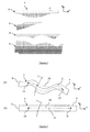
Figure 1 shows a vertical cross-section view of a 3D geological domain composed of four sequences, with horizons, faults and unconformities; -
Figure 2 shows a vertical cross-section view of an unstructured conformal mesh fitted in the geological domain ofFigure 1 ; -
Figure 3 shows a vertical cross-section view of the depositional spaces associated with the geological domain ofFigures 1 and 2 (one depositional space per sequence), as calculated with a FEM method; -
Figure 4 illustrates the difference between Euclidean distances and geodesic distances when measured (a) in the present-day geological domain, and (b) in the depositional space; -
Figure 5 illustrates a sequence of operations according to the invention: (a) in a present-day geological domain whose boundaries have been identified, (b) discretizing boundaries and/or layers with 2D or 3D conformal meshes, and (c) computing the depositional space. (d) shows a detail of the layer shown in (c) in the depositional space around a fault, where some horizontal slip can be observed as a result of the mechanical simulation; -
Figure 6 illustrates a post-processing method, showing in (a) the 3D high-resolution mesh populated in the depositional space with material properties simulated in that space, and in (b) an inner view of another mesh representing a layer of the present-day geological domain populated with the properties simulated in the mesh shown in (a). -
Figure 7 illustrates a post-processing method for building a 3D hybrid grid (mostly structured) representing the present-day geometry of the geological domain, populated with properties simulated in the depositional space produced by the method according to the invention: are shown in (a) the 3D geological domain with the layers and boundaries identified, in (b) the same geological domain meshed with the created grid, populated with properties simulated in the depositional space, and in (c) a separated view of the sequences of the geological domain shown in (b). - With reference to
Figures 1 and 2 , without any loss of generality and unless otherwise specified, the following definitions of terms relative to geological structure modeling apply throughout the present document: - "Meshes" 9 refer to partitions of a domain into smaller geometrical subsets called "elements," 11. So meshes 9 are discrete models of the domain they represent. Elements of three dimensional (3D) meshes are volumetric, like tetrahedra or cuboids.
Elements 12 of bidimensional (2D) meshes are planar, like triangles or quadrilaterals, although they have a 3D geometry; - Each
single element 11 of amesh 9 connects a variable number of arbitrary points (at least four) of the 3D domain called "nodes" 10; - A
mesh 9 is "structured" if such connections between thenodes 10 follow the same elementary pattern for all the nodes of the mesh. Otherwise, a mesh is said to be "unstructured", and in that case nodes have a variable number of connections with other nodes; - The "faces" of an element refer to the non-empty intersections of this element with any plane in the 3D space, provided that the element is entirely included in one of the two half-spaces defined by the plane. The set of such faces of dimension 0 are the nodes of the element, the set of such faces of
dimension 1 are referred to as the "edges" of the element, and the set of such faces ofdimension 2 are referred to as the "facets" 12 of the element (an element of a 2D mesh has no facets, only nodes and edges); - At a basin or a reservoir scale, 3D
geological domains 1 are bounded by external and internal limits referred to as "boundaries" 4. A boundary is a 2D object equivalent to a surface, embedded in the 3D space; - A
3D mesh 9 representing a 3D geological domain is said to be "conformal," if there is a subset offacets 12 of the 3D mesh matching (in the most general sense) a givenboundary 4, such subset of facets forming an approximation of the geometry of the boundary; - A
2D mesh 9 representing a 3D geological domain is said to be "conformal" if there is a subset of elements of the 2D mesh matching (in the most general sense) a givenboundary 4, such subset of elements forming an approximation of the geometry of the boundary; - "Faults" 7 refer to boundaries of a 3D geological domain corresponding to discontinuities or breaks in the rock;
- "Horizons" 5 refer to boundaries of a 3D geological domain separating younger rock from older rock without representing a gap in the geologic record;
- As opposed to
horizons 5, theboundaries 4 of a 3D geological domain separating younger rock from older rock and that represent a gap in the geologic record are referred to as "unconformities" 6. - "Isochrons" refer to surfaces joining points of the present-day space where sediments deposited at the same time.
Horizons 5 are typically isochrons, whereasunconformities 6 are not. In all the following, "horizons" refer to specific isochrons identified within a geological domain. - The closed regions of space entirely bounded by
boundaries 4 of a 3D geological domain, thus corresponding to sub-volumes of said domain, are referred to as "layers" 3; - "Sequences" 8 refer to sets of layers bounded by
unconformities 6. This definition implies that the sedimentary deposits of asequence 8 occurred continuously through time, without erosion or hiatus in deposition of sediments. - In the following description, several embodiments of the invention are described and specific examples are put forward in order to provide a thorough understanding of the invention. However, it will also be apparent to someone skilled in the art that other embodiments are possible and the invention is not limited to the examples described herein. Furthermore, features usually well known by someone skilled in the art may be omitted or simplified in order to avoid obscuring the description of the embodiments of the invention.
- With reference to
Figure 1, 2 and3 , the method according to the invention comprises the following steps: - A "boundary matching" step, for associating each
relevant boundary 4 of thegeological domain 1 with a unique "geological ID". That geological ID is also associated withfacets 12 of a 3Dconformal mesh 9 or withelements 12 of a 2D mesh which approximate the geometry of theboundary 4, thereby allowing to retrieve unambiguously either all thefacets 12 of a 3Dconformal mesh 9 or all the elements of a2D mesh 12 that correspond to a givenboundary 4 of thegeological domain 1. This step needs to apply only to theboundaries 4 which are involved in the further steps of the method; - A "mechanical simulation setup step", for setting the boundary conditions necessary to ensure that the produced geometry of the 3D
geological domain 1 in thedepositional space 2 is such that both properties "P1" and "P2" are honored (without any intention to be limitative); - A "mechanical simulation step" for computing everywhere in the present-day space fitted with coordinates (x, y, z) the field of displacements (dx, dy, dz) that matches the prescribed boundary conditions, in such a way that its computation honors the principles of physics that govern rock deformation. The computed displacements allow defining a depositional coordinate system (u, v, w) such as:
- u(x, y, z) = x + dx(x, y, z),
- v(x, y, z) = y + dy(x, y, z) and
- w(x, y, z) = z + dz(x, y, z).
- The present time
geological domain 1 ofFigures 1 and 2 are cross-section views at constant y, so only x and z coordinates are shown. The representation in the depositional space ofFigure 3 is a cross-section view at constant v, so only u and w coordinates are shown. - With reference to
Figure 4 , advantageously, the method of the invention allows defining adepositional space 2 fitted with a depositional coordinate system (u, v, w) honoring both properties "P1" and "P2", where the geometry of the 3D geological domain is physically reliable, thereby allowing the definition of a low-distorted computational space where measured Euclidean distances 20 are close to geodesic distances 21. When applied in thatdepositional space 2, geostatistical interpolations or simulation algorithms can advantageously model the physical properties of the 3D geological domain with an improved accuracy. The generation of meshes honoring the complex geometries of geological structures can also be made much easier when performed in that depositional space. As another example, the quality of a 3D seismic reflection interpretation can be more precisely checked if run in that depositional space. - There are potentially many possible implementation methods for the boundary matching step, depending on the algorithms and the data structures it uses. Usually, the more complex a data structure, the simpler the algorithm will be, although the simplicity of the algorithm is altered by the data structure update management. On the other hand, a simple data structure is efficient to update but forces the algorithm to perform explicitly a set of operations to recreate some data needed each time. As a consequence, the final choice is often a compromise.
- The geological IDs associated with the boundaries of the
geological domain 1, B = {B1, B2, B3, ..., Bn}, where B is the restricted set ofboundaries 4 involved in the further steps of the method, can be represented by a series of n arbitrary integer numbers {b1, b2, b3, ..., bn}. Although not mandatory and for the sake of clarity, B may be represented by a linear list of n records, that is a set of n records whose structural properties essentially involve only the relative position of the records. Record positions can be put into a one-to-one correspondence with the set of the first n integers, so that the geological ID bi, associated with the ith record of the list B, may be equal to i. - With reference to
figure 5 , in a first embodiment, the geological domain can be represented by a 3Dconformal mesh 9 whoseelements 11 are all tetrahedra. The generation of the mesh is not within the scope of the invention and can be done following any classical method known in the art. Each tetrahedron has fourfacets 12, and each of these four facets can be simply identified with an index between 1 and 4. Facets in the tetrahedral mesh may thus be represented unambiguously by a pair (T, J) where T is a tetrahedron and J an index between 1 and 4. Let us also consider that the data structure representing a single tetrahedron t is encoded so that memory slots are reserved to store and retrieve an array of four integer values A(t) = {a1, a2, a3, a4}, each aj being associated with the facet (t, j), the jth facet of t. The values of the aj may be set as follows: - if the facet (t, j) does not match a boundary of set B, then aj = -1,
- if the facet (t, j) matches the boundary with ith record in set B, then aj is equal to the corresponding geological ID bi (aj = i for instance).
- The method assumes that the tetrahedral mesh is conformal, so there is at least one facet that matches each of the
boundaries 4 contained in the set B. The values of aj may be set during an initialization step taking place at the beginning of the boundary matching step. Then, retrieving all the facets of the tetrahedral mesh that correspond to a given boundary Bi of the geological domain may involve the following steps: - first, creating an empty linear list of facets Fi,
- next, retrieving the geological ID bi corresponding to Bi (equal to i for example),
- finally, exploring all the tetrahedra of the mesh, and if for the current tetrahedron t, there is a j such that in A(t), aj = bi, inserting the facet (t, j) into Fi.
- The list of facets Fi may be further split into two lists Fi+ and Fi-. The list Fi+ contains all the facets of Fi having a normal vector that locally matches (in the most general sense) the normal vector of the boundary Bi, the normal vector of a facet (T, I) being for example defined as the normal vector to the plane defined by the three nodes of the facet pointing towards the exterior of T. The list Fi- contains all the other facets of Fi. These two lists may be used to retrieve all the facets that correspond to a given side ("+" or "-") of a given boundary of the geological domain.
- In that first embodiment or as soon as the present-day geometry of the
geological domain 1 is represented by a 3Dconformal mesh 9 whoseelements 11 are general polyhedra, the unknown displacements (dx, dy, dz) can be advantageously determined using a Finite Element Method (FEM). The FEM method is a classical numerical method, well known from the one skilled in the art, so it will be only partially described here in order not to obscure embodiments of the invention. A detailed description can be for instance found in the book by Zienkiewicz and Taylor, "The Finite Element Method - Volume 1: The Basis", Butterworth-Heinemann editions (2000). - In that embodiment, referred to as the FEM method, every
element 11 of the 3Dconformal mesh 9 is associated with at least two parameters representing the mechanical properties of the material contained in the portion of the geological domain corresponding to the inside of that element. The number of parameters depends on the solid material deformation model implemented. An elastic deformation model requires two parameters, while plastic or more advanced deformation models require more parameters. The values of the parameters can differ fromelement 11 toelement 11 through themesh 9 and also change with time during the mechanical simulation step. - If the material is assumed to deform elastically during the mechanical simulation step, these parameters are usually the Poisson's ratio and the Young's modulus (or the corresponding Lamé coefficients) relative to the material contained in the mesh element.
- In order to honor the "P1" property, a boundary condition is set to prescribe that all the
nodes 10 of thefacets 12 corresponding to a givenhorizon 5 of thegeological domain 1 have the same final w(x, y, z) value, so as to appear as a plane in the depositional space as shown infigure 5(c) . That value can be left as an output of the mechanical simulation step, or can be explicitly specified. - In order to honor the "P2" property, another boundary condition is set to prescribe that all the
nodes 10 of thefacets 12 corresponding to a given side of a givenfault 7 orhorizon 5 of thegeological domain 1 are free to move provided that they stay in contact with the facets corresponding to the other side of thefault 7 orhorizon 5. Optionally, another boundary condition may be set to prescribe that all thenodes 10 located at the intersection between a givenhorizon 5 of thegeological domain 1 and a given side of a givenfault 7 of thegeological domain 1 are free to move provided that they stay in contact with the edges corresponding to the intersection between thehorizon 5 and the other side of thefault 7.Figure 5(d) shows an example of how afault 7 appears in the depositional space, with the two sides having stayed mechanically in contact without interpenetrations, but free so slide. - The computation of the unknown displacements (dx, dy, dz) at the location of each
node 10 of the3D mesh 9 representing the present-day geometry of thegeological domain 1 is done with a Finite Element Method based on the boundary conditions defined in the previous mechanical simulation setup step. - Advantageously, each
sequence 8 identified in thegeological domain 1 can be processed separately, leading to a representation of its owndepositional space 2, as shown onFigure 3 . - The FEM computation can be done by building a global stiffness matrix as done in any classical implicit Finite Element Method known in the art.
- Alternatively, The FEM computation can be done iteratively by building and updating local stiffness matrices defined at the
nodes 10 of the3D mesh 9 representing the present-day geometry of thegeological domain 1, allowing forces to be transmitted from node to node (or from a set of nodes to other sets of nodes) until equilibrium is obtained as done in any "dynamic relaxation", "multi-agent", Block Gauss-Seidel or Block Jacobi method known in the art. Such methods are described for instance in the book by Saad, "Iterative Methods for Sparse Linear Systems", Siam editions (2003). - The FEM computation is not limited to the small displacement hypothesis and can handle large deformations, avoiding in that case the undesirable side effects of rotations.
- In order to constrain the
nodes 10 to stay mechanically in contact with sets offacets 12 or edges, as it might be prescribed by some boundary conditions defined in the mechanical simulation setup step, a "master/slave" formulation is used. That formulation can be for instance based on a classical penalty method or on the use of Lagrange multipliers. - In the following, an example of application of the Finite Element Method to the computation of mechanical deformation of solid materials is given, based on an elastic deformation model. Only a brief overview is given, as the FEM method itself is common knowledge.
- Under the small displacement hypothesis, the Green-Lagrange deformation tensor ε is defined by:

where dI,J denotes the J th partial derivative of the I th component of the unknown displacement d = (dx, dy, dz). For isotropic elastic solids, the stress tensor σ is given by the Hooke's law:
where the Lamé coefficients λ and µ are defined from the Young's modulus E and Poisson's ratio v:

- The momentum conservation equation in the quasi-static case gives:

with usual displacement and boundary conditions. In particular, whennodes 10 are required to stay mechanically in contact with sets offacets 12 or edges, a non-penetration constraint is set, prescribing that the distance of the projection of such nodes on such sets of facets or edges to the local normal plane to the nodes is null ("master/slave" formulation). - According to the Finite Element Method, the unknown displacement field d is searched in the kinematic admissible displacement field D. We also define the space V of "test" admissible virtual displacement field v. The virtual work principle gives the momentum conservation law as an integral form:

where Ωs is the considered solid defined by its spatial coordinates. The latter equation can be considered as a minimization problem of a functional. Then, in order to take into account the non-penetration constraints, the minimization problem is rewritten, replacing the functional by a Lagrangian function L(d, λ), where λ is an unknown Lagrange multiplier. Let h be the mesh used for the discretization of the considered solid. The Finite Element Method approximates the unknowns dh and λh on finite dimensional spaces, and a non-linear vectorial system R(dh, λh) may be obtained by enforcing:
where { g1, ..., gn } and { Λ1, ..., Λ n } are the basis of given shape functions approximating displacements and Lagrange multipliers respectively. The resulting non-linear system can be solved iteratively in order to nullify the first order residual at step (n+1) according that R(dh, λh ) is not null at step n. Defining:
it follows that:
where
is the tangent matrix of the residual R. This matrix system can be directly inversed in two dimensions with a LU factorization, or solved iteratively in three dimensions with an Uzawa or Minimal Residual Fashion algorithm (see for example Saad, "Iterative Methods for Sparse Linear Systems", Siam editions (2003)). - Finally, the solved nodal displacements (dx, dy, dz) are used to define the depositional coordinate system (u, v, w) at the location of each
node 10 used in the 3Dconformal mesh 9. Referring toFigures 2 and3 , a point P with Cartesian coordinates (x, y, z) in the present-daygeological domain 1 is attributed (u, v, w) coordinates in thedepositional space 2. - The computation of the value at any present-day location (x, y, z) of a
property 30 simulated by any geostatistical method performed in the computed depositional coordinate system (u, v, w) can be then done with the following operations: - retrieving of the mesh element containing the given present-day location (x, y, z),
- assuming that the depositional coordinates (u, v, w) within each
mesh element 11 are fully defined by their values at the nodes of said element, computing of the depositional coordinates (u, v, w) of given present-day location (x, y, z) using an analytical interpolation scheme based on the values of the depositional coordinates at thenodes 10 of the container element, - retrieving the element of the 3D high-
resolution mesh 35 of the depositional space on which the geostatistical method has been applied, which contains the computed location (u, v ,w), - retrieving the value of the simulated property attached to said element.
- In a second embodiment, the
geological domain 1 can be represented by a set M of 2D independent meshes (for example made of triangles 12), each of these meshes representing aboundary 4 of the set B. The generation of the 2D meshes is not within the scope of the invention and can be done following any classical method known in the art. M can be represented for instance by a linear list M = {M1 ,M2 ,M3 , ..., Mn}. The data structure representing such a triangular mesh Mj is encoded so that memory slots are reserved to store and retrieve an integer value A(Mj). The value of A(Mj) is set so that if the mesh Mj represents the boundary Bi, then A(Mj) is equal to the corresponding geological ID bi (equal to i for example). The value of the A(Mj) may be set during an initialization step taking place at the beginning of the boundary matching step. Then, retrieving all the triangles that correspond to a given boundary Bi of the geological domain may involve the following steps: - first, creating an empty linear list of elements Ti,
- next, retrieving the geological ID bi corresponding to Bi (equal to i for example),
- finally, exploring all the meshes of set M, and if for the current mesh with index j, A(Mj) = bi, inserting all the elements of Mj into Ti.
- In that second embodiment, the unknown displacements (dx, dy, dz) are advantageously determined using a Boundary Element Method (BEM). The BEM method is a classical numerical method, well known from the one skilled in the art, so it will be only partially described here in order not to obscure embodiments of the invention. A detailed description can be for instance found in the book by Aliabadi, "The Boundary Element Method: Applications in Solids and Structures - Vol. 2", Wiley editions (2002).
- In the context of geomechanics, a Boundary Element representation applies when the partial differential equations (PDEs) governing the deformation of rocks are piecewise homogeneous, and for which a Green's function can be found or approximated. In such cases, the unknown displacement of the system can be reduced to the self-contained displacement of the
interfaces separating layers 3 with homogeneous mechanical properties. The Boundary Element Method uses the given boundary conditions to fit boundary values into the integral equation. - The BEM method assumes that the present-day geometry of the geological domain is represented by a set of 2D meshes, each of these meshes representing a
boundary 4 of said geological domain (seefigure 5 ), and that theelements 12 of said 2D meshes are general polygons. As the functions used for approximating the solution inside the geological domain are chosen to be only those which satisfy the governing equations exactly, no volumetric (3D) elements are needed. - Each
individual polygon 12 forming the 2D meshes can be associated with mixed traction-displacement boundary conditions, and when such boundary conditions are specified, the method solves the corresponding unknown displacements. The polygons can advantageously be triangles, but common Boundary Element Methods naturally handle other types of polygons. - In that embodiment, referred to as the BEM embodiment, every layer of the geological domain is associated with at least two parameters representing the mechanical properties of the material contained in the portion of the geological domain corresponding to the inside of that layer, thus defining a homogeneous material for that layer. The number of parameters depends on the solid material deformation model implemented. An elastic deformation model requires two parameters, while plastic or more advanced deformation models require more parameters. The values of the parameters can change with time during the mechanical simulation step.
- If the material is assumed to deform elastically during the mechanical simulation step, these parameters are usually the Poisson's ratio and the Young's modulus (or the corresponding Lamé coefficients) relative to the material contained in the layer.
- In order to honor the "P1" property, a boundary condition is set to prescribe that all the
nodes 10 of theelements 12 corresponding to a givenhorizon 5 of thegeological domain 1 have the same final w(x, y, z) value, so as to appear as a plane in the depositional space as shown infigure 5(c) . That value can be left as an output of the mechanical simulation step, or can be explicitly specified. - In order to honor the "P2" property, another boundary condition is set to prescribe that all the
nodes 10 of theelements 12 corresponding to a given side of a givenfault 7 orhorizon 5 of thegeological domain 1 are free to move provided that they stay in contact with the elements corresponding to the other side of thatfault 7 orhorizon 5. Optionally, another boundary condition can be set to prescribe that all thenodes 10 located at the intersection between a givenhorizon 5 of thegeological domain 1 and a given side of a givenfault 7 of thegeological domain 1 are free to move provided that they stay in contact with the edges corresponding to the intersection between saidhorizon 5 and the other side of saidfault 7.Figure 5(d) shows an example of how afault 7 appears in the depositional space, with the two sides having stayed in contact without interpenetrations, but free so slide. - The computation of the unknown displacements (dx, dy, dz) at the location of each
node 10 of the 2D meshes representing the present-day geometry of thegeological domain 1 is done with a Boundary Element Method based on the boundary conditions defined in the previous mechanical simulation setup step. Eachsequence 8 identified in thegeological domain 1 can be processed separately. The BEM computation is not limited to the small displacement hypothesis and can handle large deformations, avoiding in that case the undesirable side effects of rotations. - Optionally, other unknown displacements (dx, dy, dz) can be computed at arbitrary present-day locations (x, y, z) referred to as "observation points", using the computed displacements at the location of each
node 10 of the 2D meshes representing the present-day geometry of thegeological domain 1, as described in any Boundary Element Method known in the art. - In the following, an example of application of the Boundary Element Method to the computation of mechanical deformation of solid materials is given, based on an elastic deformation model. Only a brief overview is given, as the BEM method itself is of common knowledge.
- This method assumes that the constitutive and equilibrium equations defining the mechanical problem involve two operators or matrices T(p, q) and U(p, q), where T(p, q) is the traction operator giving the tractions t at "field" point q due to a unit load at "source" point p, and U(p, q) is a Green's function giving the displacement d at "field" point q due to a unit load at "source" point p. For example, these two operators can be given by the fundamental solutions of linear elasticity. The Betti theorem gives the unknown displacement d at point p:

where S is the boundary of the considered solid. Using a discretization of S into polygonal elements, we obtain the system of equations:
with t the set of prescribed tractions, and MT and Mu two dense and non-symmetric matrices. Therefore, the amount of computer memory needed to store the system of equations is in the order of n 2 and the complexity of an iterative solver is in the order of k·n 2, with n being the number of unknowns and k the number of iterations needed to solve the system. However, specific techniques such as multipole expansion (as described for instance in Geengard and Rokhlin, "A Fast Algorithm for Particle Simulations", J. Comput. Phys., Vol. 73, 1987) or hierarchical matrices (as described for instance in Hackbusch, "A Sparse Matrix Arithmetic Based on H-Matrices - Part I - Introduction to H-Matrices", Computing, Vol. 86, ) can be used to reduce the complexity in the order of n·log(n). - Finally, the solved nodal displacements (dx, dy, dz) are used to define the depositional coordinate system (u, v, w) at the location of each
node 10 of the 2D meshes representing the present-day geometry of thegeological domain 1 and/or at any observation point. - With reference to
Figures 6 and7 , The computation of the value at any present-day location (x, y, z) of aproperty 30 simulated by any geostatistical method performed in the computed depositional coordinate system (u, v, w) can be done with the following operations: - computing the depositional coordinates (u, v, w) of a given present-day location (x, y, z), which has been previously computed as an observation point,
- retrieving the element of the 3D high-
resolution mesh 35 of the depositional space on which the geostatistical method has been applied, which contains the computed location (u, v, w), - retrieving the value of the simulated property attached to that element.
- More generally, the invention includes also a post-processing method for "painting" the elements of a
3D mesh 9 representing the present-day geometry of ageological domain 1 withproperties 30 simulated in the depositional space which has been produced by the method according to the invention. It comprises the following steps: - for each element e of a
3D mesh 9 partitioning the volume of the present-day geological domain, computing the present-day location b of its barycenter, - computing the depositional coordinates b' corresponding to the present-day location b as previously described, using a "FEM" or a "BEM" method,
- retrieving the element c of a (usually) high
resolution 3D mesh 35 partitioning the volume of thedepositional space 2 to which the geostatistical method has been applied and which contains the computed location b', - retrieving the value of the
simulated property 30 attached to said element c, - finally, associating that value with the element e.
- Illustrations of this process can be found on
Figures 6 and7 . InFigure 6(b) , a 3D mesh 9 (which may be the one already used for the calculation of the depositional space 2) is populated with theproperties 30 computed in thedepositional space 2 fitted with a high-density mesh 35 as shown onfigure 6(a) . InFigure 7(b) ,properties 30 computed in thedepositional space 2 are integrated in the geological domain following a new 3D mesh, mostly structured, which fits better for the application. InFigure 7(c) sequences are displayed separately for a better comprehension. - Any method embodiment (or portion thereof) described herein may be implemented in terms of program instructions. The program instructions may be stored on any of various kinds of readable computer memory media. The program instructions may by readable and executable by any computer or set of computers to implement the method embodiment (or portion thereof).
- While this invention has been described in conjunction with a number of embodiments, it is evident that many alternatives, modifications and variations would be or are apparent to those of ordinary skill in the applicable arts. Accordingly, it is intended to embrace all such alternatives, modifications, equivalents and variations that are within the spirit and scope of this invention, the essential point being to use the theory of mechanics and rock deformation to build a depositional space, advantageously, (i) where isochrons (horizons) identified within a 3D geological domain are substantially planar and parallel, (ii) such that every point of the depositional space located inside a stratigraphic sequence has one and exactly one corresponding location in the present-day space, and (iii) where the geometry of the 3D geological domain is physically reliable, said depositional space being thus used as a computational space for applications like accurate modeling and interpolation of the physical properties of the subsurface, mesh generation for complex geometries of geological structures, or quality checking of a 3D seismic reflection interpretation.
Claims (25)
- A method for building a depositional space (2) corresponding to a geological domain (1), comprising the steps of:- partitioning said geological domain (1) with at least one conformal mesh (9) sensibly matching the boundaries (4) of said geological domain (1),- calculating depositional coordinates defining a depositional space (2),wherein said depositional coordinates calculation comprises calculations of fields of displacement including simulations of mechanical deformations in the geological domain (1), using a solid material deformation model.
- A method according to claim 1, with (i) said conformal mesh (9) implementing element coordinates (x, y, z), (ii) depositional coordinates (u, v, w) being defined as u = u(x, y, z), v = v(x, y, z), w= w(x, y, z), and (iii) fields of displacement (dx, dy, dz) being defined such as:u(x, y, z) = x + dx(x, y, z),v(x, y, z) = y + dy(x, y, z),w(x, y, z) = z + dz(x, y, z),wherein the calculation of the depositional coordinates (u, v, w) includes:- a boundary matching step, comprising an operation of associating boundaries (4) of the geological domain (1) each with a set of mesh facets or elements sensibly matching the geometry of said boundary (4), said set including at least one facet of a 3D conformal mesh or element of a 2D conformal mesh (12),- a mechanical simulation setup step, comprising a definition of boundary conditions aiming at constraining the calculated geometry of the geological domain in the depositional space (2),- a mechanical simulation step, comprising a calculation in the geological domain (x, y, z) of a field of displacements (dx, dy, dz) matching said boundary conditions.
- A method according to claim 2, wherein the mechanical simulation setup step further comprises the definition of a boundary condition prescribing that the nodes (10) matching a given horizon (5) of the geological domain (1) have substantially the same final w(x, y, z) value.
- A method according to claim 3, wherein the final w(x, y, z) value corresponding to a given horizon (5) is one of the following:- an output of the mechanical simulation step,- a value which is explicitly specified.
- A method according to claim 3 or 4, wherein the boundary condition prescribes further that the angle between pairs of adjacent facets or elements corresponding to the horizon (5) is substantially equal to 180 degrees of arc.
- A method according to any of the claims 3 to 5, wherein the mechanical simulation setup step further comprises the definition of a boundary condition prescribing that the nodes (10) matching a given side of a given fault (7) of the geological domain (1) are free to move provided that they stay in contact with the other side of said fault (7).
- A method according to claim 6, wherein the mechanical simulation setup step further comprises the definition of a boundary condition prescribing that the nodes (10) located at the intersection between a given horizon (5) of the geological domain (1) and a given side of a given fault (7) of the geological domain (1) are free to move provided that they stay in contact with the edges corresponding to the intersection between said horizon (5) and the other side of said fault (7).
- A method according to any of the claims 3 to 7, wherein the mechanical simulation setup step further comprises the definition of a boundary condition prescribing that the nodes (10) matching a given side of a given horizon (5) of the geological domain (1) are free to move provided that they stay in contact with the other side of said horizon (5).
- A method according to any of the claims 3 to 8, wherein the displacements (dx, dy, dz) are computed for the nodes (10) of the mesh(es) (9) representing the geometry of the geological domain (1).
- A method according to any of the claims 3 to 9, wherein sequences (8) identified in the geological domain (1) are processed separately.
- A method according to any of the claims 3 to 10, wherein the mechanical simulation step further comprises the use of a "master/slave" formulation to constrain the displacements (dx, dy, dz) of the nodes (10) to stay mechanically in contact with sets of elements, facets or edges as prescribed by boundary conditions.
- A method according to claim 11, wherein the master/slave formulation is based on a penalty method.
- A method according to claim 11, wherein the master/slave formulation is based on the use of Lagrange multipliers.
- A method according to any of the claims 2 to 13, wherein the field of displacements (dx, dy, dz) is calculated using a Finite Element Method (FEM), the geometry of the geological domain (1) being represented by at least one 3D conformal mesh (9).
- A FEM method according to claim 14, wherein the 3D conformal meshes (9) are hybrid, and comprise structured groups of elements (11) and unstructured groups of elements (11).
- A FEM method according to claim 14 or 15, wherein elements (11) of the 3D conformal meshes (9) are associated with parameters representing the local mechanical properties of the material contained in the portion of the geological domain (1) enclosed in said element (11).
- A FEM method according to claim 16, wherein the solid material deformation model is an elastic deformation model.
- A FEM method according to any of the claims 14 to 17, wherein the displacements (dx, dy, dz) are computed using one of the following method:- by building a global stiffness matrix,- iteratively by building and updating local stiffness matrices defined at the nodes (10) of the 3D mesh (9) representing the geometry of the geological domain (1).
- A FEM method according to any of the claims 14 to 18, further comprising the computation at location (x, y, z) in the geological domain (1) of the value of a terrain property (30) calculated at location (u, v, w) in the depositional space (2), said terrain property computation comprising the following steps:- retrieving the mesh element (11) containing the location (x, y, z),- computing the depositional coordinates (u, v, w) of said location (x, y, z) using an analytical interpolation scheme based on the values of the depositional coordinates (u, v, w) corresponding to the nodes coordinates (x, y, z) of said container mesh element (11),- retrieving the value of said terrain property (30) corresponding to coordinates (u, v, w) in the depositional space (2).
- A method according to any of the claims 2 to 12, wherein the field of displacements (dx, dy, dz) is calculated using a Boundary Element Method (BEM), the geometry of the geological domain (1) being represented by a set of 2D conformal meshes, each of these meshes representing a boundary (4) of said geological domain (1).
- A BEM method according to claim 20, wherein the 2D conformal meshes (9) are hybrid, and comprise structured groups of elements (12) and unstructured groups of elements (12).
- A BEM method according to claim 20 or 21, wherein the solid material deformation model is an elastic deformation model.
- A BEM method according to any of the claims 20 to 22, wherein the mechanical simulation setup step further comprises the computation of displacements (dx, dy, dz) at arbitrary locations (x, y, z) referred to as "observation points", using computed displacements (dx, dy, dz) at the location of the nodes (10) of the 2D meshes (12) representing the geometry of the geological domain (1).
- A BEM method according to any of the claims 20 to 23, further comprising the computation at location (x, y, z) in the geological domain (1) of the value of a terrain property (30) calculated at location (u, v, w) in the depositional space (2), said terrain property computation comprising the following steps:- computing the depositional coordinates (u, v, w) of said location (x, y, z) used as an observation point,- retrieving the value of said terrain property (30) corresponding to coordinates (u, v, w) in the depositional space (2).
- A computer program implementing the method according to any of the preceding claims.
Priority Applications (7)
| Application Number | Priority Date | Filing Date | Title |
|---|---|---|---|
| EP09306043.2A EP2317348B1 (en) | 2009-10-30 | 2009-10-30 | Method for building a depositional space corresponding to a geological domain |
| US12/622,937 US8315845B2 (en) | 2009-10-30 | 2009-11-20 | Method for building a depositional space corresponding to a geological domain |
| CA2717889A CA2717889C (en) | 2009-10-30 | 2010-10-18 | Method for building a depositional space corresponding to a geological domain |
| NO20101488A NO20101488A1 (en) | 2009-10-30 | 2010-10-22 | Method of constructing a sedimentation space corresponding to a geological area |
| FR1058694A FR2952210A1 (en) | 2009-10-30 | 2010-10-22 | METHOD FOR CONSTRUCTING A DEPOSITION AREA CORRESPONDING TO A GEOLOGICAL DOMAIN |
| BRPI1004063-3A BRPI1004063A2 (en) | 2009-10-30 | 2010-10-28 | Method for constructing a depositional space corresponding to a geological domain and computer program |
| GB1018252.5A GB2474959B (en) | 2009-10-30 | 2010-10-29 | Method for building a depositional space corresponding to a geological domain |
Applications Claiming Priority (1)
| Application Number | Priority Date | Filing Date | Title |
|---|---|---|---|
| EP09306043.2A EP2317348B1 (en) | 2009-10-30 | 2009-10-30 | Method for building a depositional space corresponding to a geological domain |
Publications (2)
| Publication Number | Publication Date |
|---|---|
| EP2317348A1 true EP2317348A1 (en) | 2011-05-04 |
| EP2317348B1 EP2317348B1 (en) | 2014-05-21 |
Family
ID=42110250
Family Applications (1)
| Application Number | Title | Priority Date | Filing Date |
|---|---|---|---|
| EP09306043.2A Active EP2317348B1 (en) | 2009-10-30 | 2009-10-30 | Method for building a depositional space corresponding to a geological domain |
Country Status (7)
| Country | Link |
|---|---|
| US (1) | US8315845B2 (en) |
| EP (1) | EP2317348B1 (en) |
| BR (1) | BRPI1004063A2 (en) |
| CA (1) | CA2717889C (en) |
| FR (1) | FR2952210A1 (en) |
| GB (1) | GB2474959B (en) |
| NO (1) | NO20101488A1 (en) |
Cited By (10)
| Publication number | Priority date | Publication date | Assignee | Title |
|---|---|---|---|---|
| CN102520448A (en) * | 2012-01-06 | 2012-06-27 | 中国石油化工股份有限公司胜利油田分公司西部新区研究中心 | System for calibrating well earthquakes in chronostratigraphic cycle domain |
| US8315845B2 (en) | 2009-10-30 | 2012-11-20 | Schlumberger Technology Corporation | Method for building a depositional space corresponding to a geological domain |
| EP2778725A3 (en) * | 2013-03-15 | 2015-03-04 | Paradigm Sciences Ltd. | Systems and methods to build sedimentary attributes |
| US9690002B2 (en) | 2015-06-18 | 2017-06-27 | Paradigm Sciences Ltd. | Device, system and method for geological-time refinement |
| US9728003B1 (en) | 2009-10-23 | 2017-08-08 | Paradigm Sciences Ltd. | Systems and methods for coordinated editing of seismic data in dual model |
| CN108109203A (en) * | 2017-11-14 | 2018-06-01 | 中国市政工程中南设计研究总院有限公司 | Based on the geological boundary cloud data extracting method and system under BIM environment |
| US10338252B1 (en) | 2009-06-01 | 2019-07-02 | Emerson Paradigm Holding Llc | Systems and processes for building multiple equiprobable coherent geometrical models of the subsurface |
| US10466388B2 (en) | 2016-09-07 | 2019-11-05 | Emerson Paradigm Holding Llc | System and method for editing geological models by switching between volume-based models and surface-based structural models augmented with stratigraphic fiber bundles |
| US10520644B1 (en) | 2019-01-10 | 2019-12-31 | Emerson Paradigm Holding Llc | Imaging a subsurface geological model at a past intermediate restoration time |
| US11156744B2 (en) | 2019-01-10 | 2021-10-26 | Emerson Paradigm Holding Llc | Imaging a subsurface geological model at a past intermediate restoration time |
Families Citing this family (61)
| Publication number | Priority date | Publication date | Assignee | Title |
|---|---|---|---|---|
| US8374836B2 (en) * | 2008-11-12 | 2013-02-12 | Geoscape Analytics, Inc. | Methods and systems for constructing and using a subterranean geomechanics model spanning local to zonal scale in complex geological environments |
| FR2948215B1 (en) * | 2009-07-16 | 2011-06-24 | Inst Francais Du Petrole | METHOD FOR GENERATING A HEXA-DOMINANT MESHING OF A FAILLED UNDERGROUND MEDIUM |
| US8655632B2 (en) * | 2009-09-03 | 2014-02-18 | Schlumberger Technology Corporation | Gridless geological modeling |
| US20120221302A1 (en) * | 2009-11-23 | 2012-08-30 | Jerome Lewandowski | Method and System For Modeling Geologic Properties Using Homogenized Mixed Finite Elements |
| EP2564309A4 (en) | 2010-04-30 | 2017-12-20 | Exxonmobil Upstream Research Company | Method and system for finite volume simulation of flow |
| US8432177B2 (en) * | 2010-05-12 | 2013-04-30 | Intermolecular, Inc. | High throughput current-voltage combinatorial characterization tool and method for combinatorial solar test substrates |
| FR2962835B1 (en) * | 2010-07-16 | 2013-07-12 | IFP Energies Nouvelles | METHOD FOR GENERATING A HEXA-DOMINANT MESH OF A GEOMETRICALLY COMPLEX BASIN |
| EP2599032A4 (en) | 2010-07-29 | 2018-01-17 | Exxonmobil Upstream Research Company | Method and system for reservoir modeling |
| AU2011283190A1 (en) | 2010-07-29 | 2013-02-07 | Exxonmobil Upstream Research Company | Methods and systems for machine-learning based simulation of flow |
| AU2011283193B2 (en) | 2010-07-29 | 2014-07-17 | Exxonmobil Upstream Research Company | Methods and systems for machine-learning based simulation of flow |
| US8798974B1 (en) * | 2010-09-15 | 2014-08-05 | Alan Gordon Nunns | Method and system for interactive geological interpretation, modeling and restoration |
| WO2012039811A1 (en) | 2010-09-20 | 2012-03-29 | Exxonmobil Upstream Research Company | Flexible and adaptive formulations for complex reservoir simulations |
| US8560286B2 (en) * | 2011-03-31 | 2013-10-15 | Dem Solutions Limited | Method and apparatus for discrete element modeling involving a bulk material |
| US8965745B2 (en) | 2011-04-14 | 2015-02-24 | Schlumberger Technology Corporation | Grid from depositional space |
| CN102901989A (en) * | 2011-07-29 | 2013-01-30 | 中国国土资源航空物探遥感中心 | Gravity field or magnetic field data based geologic body three-dimensional visualized modeling and interpretation method |
| FR2979152B1 (en) * | 2011-08-17 | 2013-08-23 | IFP Energies Nouvelles | METHOD FOR CONSTRUCTING A GEOLOGICAL MODEL COMPRISING A STRATIGHAPHIC UNIT DEPOSITION. |
| CN103959233B (en) | 2011-09-15 | 2017-05-17 | 埃克森美孚上游研究公司 | Optimized matrix and vector operations in instruction limited algorithms that perform eos calculations |
| US8831366B1 (en) * | 2011-11-11 | 2014-09-09 | Google Inc. | Encoding and compressing three-dimensional (3D) object data models |
| EP2631685A3 (en) | 2012-02-22 | 2016-04-20 | Service Pétroliers Schlumberger | Building faulted grids for a sedimentary basin including structural and stratigraphic interfaces |
| US10114134B2 (en) * | 2012-03-02 | 2018-10-30 | Emerson Paradigm Holding Llc | Systems and methods for generating a geological model honoring horizons and faults |
| FR2987903B1 (en) * | 2012-03-09 | 2014-05-09 | Schlumberger Services Petrol | GEOLOGICAL FAILURE STRUCTURES CONTAINING NONCONFORMITIES. |
| US10204446B2 (en) * | 2012-05-14 | 2019-02-12 | Autodesk, Inc. | Adaptively zippering meshes |
| FR2991089B1 (en) * | 2012-05-22 | 2014-05-16 | IFP Energies Nouvelles | METHOD FOR OPERATING A SUBTERRANEAN ENVIRONMENT ACCORDING TO AN OPERATING SCHEME DEFINED BY AN OPTIMIZED REPRESENTATION |
| GB2506271A (en) | 2012-08-10 | 2014-03-26 | Schlumberger Holdings | Modeling a fractured medium |
| WO2014051903A1 (en) | 2012-09-28 | 2014-04-03 | Exxonmobil Upstream Research Company | Fault removal in geological models |
| US10481297B2 (en) | 2013-01-28 | 2019-11-19 | Westerngeco L.L.C. | Fluid migration pathway determination |
| US10088596B2 (en) | 2013-03-15 | 2018-10-02 | Schlumberger Technology Corporation | Meshless representation of a geologic environment |
| GB2512372B (en) * | 2013-03-28 | 2020-07-29 | Total Sa | Method of modelling a subsurface volume |
| US9341728B2 (en) * | 2013-07-29 | 2016-05-17 | Westerngeco L.L.C. | Methods of analyzing seismic data |
| AU2014306485B2 (en) * | 2013-08-16 | 2016-12-08 | Landmark Graphics Corporation | Generating a custom reservoir from multiple compartments representing one or more geological structures |
| US10345482B2 (en) | 2013-11-26 | 2019-07-09 | Landmark Graphics Corporation | Global grid building unfaulting sequence for complex fault-network topologies |
| AU2015298233B2 (en) | 2014-07-30 | 2018-02-22 | Exxonmobil Upstream Research Company | Method for volumetric grid generation in a domain with heterogeneous material properties |
| US10359523B2 (en) | 2014-08-05 | 2019-07-23 | Exxonmobil Upstream Research Company | Exploration and extraction method and system for hydrocarbons |
| WO2016069170A1 (en) | 2014-10-31 | 2016-05-06 | Exxonmobil Upstream Research Company | Methods to handle discontinuity in constructing design space for faulted subsurface model using moving least squares |
| EP3213126A1 (en) | 2014-10-31 | 2017-09-06 | Exxonmobil Upstream Research Company | Handling domain discontinuity in a subsurface grid model with the help of grid optimization techniques |
| AU2015338996B2 (en) * | 2014-10-31 | 2018-03-22 | Exxonmobil Upstream Research Company | Managing discontinuities in geologic models |
| US10311181B2 (en) * | 2015-05-09 | 2019-06-04 | Livermore Software Technology Corp. | Methods and systems for creating computerized mesh model for layered shell-like structure |
| FR3036210B1 (en) * | 2015-05-12 | 2018-07-06 | Services Petroliers Schlumberger | GEOLOGICAL STRATIGRAPHY BY IMPLICIT AND JUMPING FUNCTIONS |
| WO2017031718A1 (en) * | 2015-08-26 | 2017-03-02 | 中国科学院深圳先进技术研究院 | Modeling method of deformation motions of elastic object |
| FR3043227A1 (en) | 2015-11-04 | 2017-05-05 | Services Petroliers Schlumberger | |
| KR101625660B1 (en) * | 2015-11-20 | 2016-05-31 | 한국지질자원연구원 | Method for making secondary data using observed data in geostatistics |
| CN105760601B (en) * | 2016-02-18 | 2017-04-05 | 中国地质大学(武汉) | A kind of method of the boundary line of ore body on Auto-matching sequence profile |
| FR3057381B1 (en) | 2016-10-07 | 2018-10-12 | Eliis | PROCESS FOR MANUFACTURING A VECTOR GEOLOGICAL MODEL |
| WO2018069744A1 (en) | 2016-10-14 | 2018-04-19 | Schlumberger Technology Corporation | Geologic structural model generation |
| WO2018118374A1 (en) | 2016-12-23 | 2018-06-28 | Exxonmobil Upstream Research Company | Method and system for stable and efficient reservoir simulation using stability proxies |
| US10724364B2 (en) * | 2017-03-06 | 2020-07-28 | Baker Hughes, A Ge Company, Llc | Creation of structural earth formation models |
| WO2018183992A1 (en) | 2017-03-31 | 2018-10-04 | Schlumberger Technology Corporation | Smooth surface wrapping of features in an imaged volume |
| US10432584B1 (en) * | 2017-06-23 | 2019-10-01 | Verisign, Inc. | Managing lame delegated domains within a managed DNS service |
| CN107423498B (en) * | 2017-07-13 | 2020-03-10 | 山东大学 | Modeling method of high-density discrete particle multiphase system |
| US11662501B2 (en) | 2018-04-03 | 2023-05-30 | ExxonMobil Technology and Engineering Company | Geologic modeling methods and systems having constrained restoration of depositional space |
| WO2020112974A1 (en) * | 2018-11-28 | 2020-06-04 | Schlumberger Technology Corporation | Implicit property modeling |
| CN109740232B (en) * | 2018-12-26 | 2023-12-08 | 北京工业大学 | Boundary condition processing method for liquid drop deposition process simulation |
| EP3956541A4 (en) * | 2019-04-15 | 2023-02-08 | Services Pétroliers Schlumberger | Modeling and simulating faults in subterranean formations |
| CN110188499B (en) * | 2019-06-05 | 2023-01-31 | 中北大学 | Method for calculating settlement of composite single pile of grouting bored concrete pile after extruding and expanding branch disc |
| CN111881531B (en) * | 2020-07-29 | 2023-08-08 | 中国人民解放军海军工程大学 | Elastic parameter calculation and dimensionless design method for four-side concave pyramid lattice structure |
| CN113178011B (en) * | 2021-04-28 | 2022-08-02 | 哈尔滨工程大学 | Cut grid THINC method for solving VOF convection equation |
| CN113380125B (en) * | 2021-05-07 | 2022-09-13 | 中铁二院工程集团有限责任公司 | Device for simulating geological fault dislocation |
| CN113408038B (en) * | 2021-07-16 | 2022-07-05 | 中国人民解放军火箭军工程大学 | Terrain interpolation method and system based on numerical simulation |
| CN113933909B (en) * | 2021-08-30 | 2024-03-19 | 核工业北京地质研究院 | Method for rapidly determining boundary of split valley basin |
| WO2023064617A1 (en) * | 2021-10-17 | 2023-04-20 | Schlumberger Technology Corporation | Reservoir simulator |
| CN114495434B (en) * | 2022-02-08 | 2024-01-12 | 北京寒武智能科技有限公司 | Landslide hazard temporary slip prediction method |
Citations (3)
| Publication number | Priority date | Publication date | Assignee | Title |
|---|---|---|---|---|
| WO2003050766A2 (en) | 2001-12-10 | 2003-06-19 | Earth Decision Sciences | Method, device and programme for three-dimensional modelling of a geological volume by 3d parametering of the geological domain |
| WO2005119304A1 (en) | 2004-06-02 | 2005-12-15 | Earth Decision Sciences | Method for building a three dimensional cellular partition of a geological domain |
| WO2006113939A1 (en) * | 2005-04-20 | 2006-10-26 | Landmark Graphics Corporation | 3d fast fault restoration |
Family Cites Families (6)
| Publication number | Priority date | Publication date | Assignee | Title |
|---|---|---|---|---|
| US6370491B1 (en) * | 2000-04-04 | 2002-04-09 | Conoco, Inc. | Method of modeling of faulting and fracturing in the earth |
| DE60225277D1 (en) * | 2001-06-06 | 2008-04-10 | Schlumberger Technology Bv | AUTOMATIC SYSTEM FOR MODELING OF STORED HIGH-PERFORMANCE HORIZONS |
| US7523024B2 (en) * | 2002-05-17 | 2009-04-21 | Schlumberger Technology Corporation | Modeling geologic objects in faulted formations |
| FR2869116B1 (en) * | 2004-04-14 | 2006-06-09 | Inst Francais Du Petrole | METHOD FOR CONSTRUCTING A GEOMECHANICAL MODEL OF A SUBTERRANEAN ZONE FOR TORQUE TO A RESERVOIR MODEL |
| FR2930350B1 (en) * | 2008-04-17 | 2011-07-15 | Inst Francais Du Petrole | PROCESS FOR SEARCHING FOR HYDROCARBONS IN A GEOLOGICALLY COMPLEX BASIN USING BASIN MODELING |
| EP2317348B1 (en) | 2009-10-30 | 2014-05-21 | Services Pétroliers Schlumberger | Method for building a depositional space corresponding to a geological domain |
-
2009
- 2009-10-30 EP EP09306043.2A patent/EP2317348B1/en active Active
- 2009-11-20 US US12/622,937 patent/US8315845B2/en active Active
-
2010
- 2010-10-18 CA CA2717889A patent/CA2717889C/en active Active
- 2010-10-22 FR FR1058694A patent/FR2952210A1/en active Pending
- 2010-10-22 NO NO20101488A patent/NO20101488A1/en not_active Application Discontinuation
- 2010-10-28 BR BRPI1004063-3A patent/BRPI1004063A2/en not_active IP Right Cessation
- 2010-10-29 GB GB1018252.5A patent/GB2474959B/en active Active
Patent Citations (3)
| Publication number | Priority date | Publication date | Assignee | Title |
|---|---|---|---|---|
| WO2003050766A2 (en) | 2001-12-10 | 2003-06-19 | Earth Decision Sciences | Method, device and programme for three-dimensional modelling of a geological volume by 3d parametering of the geological domain |
| WO2005119304A1 (en) | 2004-06-02 | 2005-12-15 | Earth Decision Sciences | Method for building a three dimensional cellular partition of a geological domain |
| WO2006113939A1 (en) * | 2005-04-20 | 2006-10-26 | Landmark Graphics Corporation | 3d fast fault restoration |
Non-Patent Citations (7)
| Title |
|---|
| "Computing", vol. 86, 1999, article "A Sparse Matrix Arithmetic Based on H-Matrices - Part I - Introduction to H-Matrices" |
| ALIABADI: "The Boundary Element Method: Applications in Solids and Structures - Vol. 2", vol. 2, 2002, WILEY EDITIONS |
| GEENGARD; ROKHLIN: "A Fast Algorithm for Particle Simulations", J. COMPUT. PHYS., vol. 73, 1987 |
| MORETTI, I., LEPAGE, F., GUITTON, M.: "Kine3D : a new restoration method based on a mixedapproach linking geometry and geomechanics", OIL&GAS SCIENCE AND TECHNOLOGY-REV. IFP, 2006, pages 277 - 289, XP002583702 * |
| SAAD: "Iterative Methods for Sparse Linear Systems", 2003 |
| SAAD: "Iterative Methods for Sparse Linear Systems", 2003, SIAM EDITIONS |
| ZIENKIEWICZ; TAYLOR: "The Finite Element Method - Volume 1: The Basis", vol. 1, 2000, BUTTERWORTH-HEINEMANN EDITIONS |
Cited By (16)
| Publication number | Priority date | Publication date | Assignee | Title |
|---|---|---|---|---|
| US10338252B1 (en) | 2009-06-01 | 2019-07-02 | Emerson Paradigm Holding Llc | Systems and processes for building multiple equiprobable coherent geometrical models of the subsurface |
| US9728003B1 (en) | 2009-10-23 | 2017-08-08 | Paradigm Sciences Ltd. | Systems and methods for coordinated editing of seismic data in dual model |
| US8315845B2 (en) | 2009-10-30 | 2012-11-20 | Schlumberger Technology Corporation | Method for building a depositional space corresponding to a geological domain |
| CN102520448B (en) * | 2012-01-06 | 2013-06-19 | 中国石油化工股份有限公司胜利油田分公司西部新区研究中心 | System for calibrating well earthquakes in chronostratigraphic cycle domain |
| CN102520448A (en) * | 2012-01-06 | 2012-06-27 | 中国石油化工股份有限公司胜利油田分公司西部新区研究中心 | System for calibrating well earthquakes in chronostratigraphic cycle domain |
| EP3418778A1 (en) * | 2013-03-15 | 2018-12-26 | Emerson Paradigm Holding LLC | Systems and methods to build sedimentary attributes |
| US9477010B2 (en) | 2013-03-15 | 2016-10-25 | Paradigm Sciences Ltd. | Systems and methods to build sedimentary attributes |
| EP2778725A3 (en) * | 2013-03-15 | 2015-03-04 | Paradigm Sciences Ltd. | Systems and methods to build sedimentary attributes |
| US10598819B2 (en) | 2013-03-15 | 2020-03-24 | Emerson Paradigm Holding Llc | Systems and methods to build sedimentary attributes |
| US9690002B2 (en) | 2015-06-18 | 2017-06-27 | Paradigm Sciences Ltd. | Device, system and method for geological-time refinement |
| US10466388B2 (en) | 2016-09-07 | 2019-11-05 | Emerson Paradigm Holding Llc | System and method for editing geological models by switching between volume-based models and surface-based structural models augmented with stratigraphic fiber bundles |
| CN108109203A (en) * | 2017-11-14 | 2018-06-01 | 中国市政工程中南设计研究总院有限公司 | Based on the geological boundary cloud data extracting method and system under BIM environment |
| CN108109203B (en) * | 2017-11-14 | 2021-04-20 | 中国市政工程中南设计研究总院有限公司 | Geological boundary point cloud data extraction method and system based on BIM environment |
| US10520644B1 (en) | 2019-01-10 | 2019-12-31 | Emerson Paradigm Holding Llc | Imaging a subsurface geological model at a past intermediate restoration time |
| US10705254B1 (en) | 2019-01-10 | 2020-07-07 | Emerson Paradigm Holding Llc | Imaging a subsurface geological model at a past intermediate restoration time |
| US11156744B2 (en) | 2019-01-10 | 2021-10-26 | Emerson Paradigm Holding Llc | Imaging a subsurface geological model at a past intermediate restoration time |
Also Published As
| Publication number | Publication date |
|---|---|
| NO20101488A1 (en) | 2011-05-02 |
| FR2952210A1 (en) | 2011-05-06 |
| GB2474959B (en) | 2012-08-22 |
| CA2717889A1 (en) | 2011-04-30 |
| US8315845B2 (en) | 2012-11-20 |
| GB201018252D0 (en) | 2010-12-15 |
| GB2474959A (en) | 2011-05-04 |
| US20110106507A1 (en) | 2011-05-05 |
| CA2717889C (en) | 2014-03-25 |
| BRPI1004063A2 (en) | 2013-02-19 |
| EP2317348B1 (en) | 2014-05-21 |
Similar Documents
| Publication | Publication Date | Title |
|---|---|---|
| EP2317348B1 (en) | Method for building a depositional space corresponding to a geological domain | |
| US10598819B2 (en) | Systems and methods to build sedimentary attributes | |
| US10088596B2 (en) | Meshless representation of a geologic environment | |
| EP2629123B1 (en) | Simulation model optimization | |
| EP2686714B1 (en) | Grid from depositional space | |
| US10795053B2 (en) | Systems and methods of multi-scale meshing for geologic time modeling | |
| US20130218539A1 (en) | Building faulted grids for a sedimentary basin including structural and stratigraphic interfaces | |
| CA2985743C (en) | Geologic stratigraphy via implicit and jump functions | |
| CA2907871C (en) | Fault representation | |
| EP2631685A2 (en) | Building faulted grids for a sedimentary basin including structural and stratigraphic interfaces | |
| EP3683601B1 (en) | Imaging a subsurface geological model at a past intermediate restoration time | |
| US20160202389A1 (en) | H-matrix preconditioner | |
| Laurent et al. | Interactive editing of 3D geological structures and tectonic history sketching via a rigid element method | |
| NO20201045A1 (en) | Fluid simulator property representation | |
| US20160034612A1 (en) | Re-ordered Interpolation and Convolution for Faster Staggered-Grid Processing | |
| CN112292714B (en) | Grid partition based on fault radiation | |
| Formaggia et al. | Numerical methods for flow in fractured porous media | |
| Busetti | Comparison of Finite Element and Elastic Dislocation Methods for Modeling Discrete Fault Stress Perturbations | |
| Hjelle | A Hamilton-Jacobi Framework for Modeling Geological Folding and Deformation | |
| Reddy | Numerical Methods, Finite Element | |
| Parquer et al. | Simulation of surface petrophysical heterogeneities on sedimentary objects |
Legal Events
| Date | Code | Title | Description |
|---|---|---|---|
| PUAI | Public reference made under article 153(3) epc to a published international application that has entered the european phase |
Free format text: ORIGINAL CODE: 0009012 |
|
| AK | Designated contracting states |
Kind code of ref document: A1 Designated state(s): AT BE BG CH CY CZ DE DK EE ES FI FR GB GR HR HU IE IS IT LI LT LU LV MC MK MT NL NO PL PT RO SE SI SK SM TR |
|
| AX | Request for extension of the european patent |
Extension state: AL BA RS |
|
| 17P | Request for examination filed |
Effective date: 20111104 |
|
| RAP1 | Party data changed (applicant data changed or rights of an application transferred) |
Owner name: LOGINED B.V. Owner name: SERVICES PETROLIERS SCHLUMBERGER Owner name: PRAD RESEARCH AND DEVELOPMENT LIMITED |
|
| RBV | Designated contracting states (corrected) |
Designated state(s): AT BE BG CH CY CZ DE DK EE ES FI FR GR HR HU IE IS IT LI LT LU LV MC MK MT NL NO PL PT RO SE SI SK SM TR |
|
| GRAP | Despatch of communication of intention to grant a patent |
Free format text: ORIGINAL CODE: EPIDOSNIGR1 |
|
| RIC1 | Information provided on ipc code assigned before grant |
Ipc: G01V 11/00 20060101AFI20131212BHEP |
|
| INTG | Intention to grant announced |
Effective date: 20140108 |
|
| RBV | Designated contracting states (corrected) |
Designated state(s): AT BE BG CH CY CZ DE DK EE ES FI FR GR HR HU IE IS IT LI LT LU LV MC MK MT NL NO PL PT RO SE SI SK SM TR |
|
| GRAS | Grant fee paid |
Free format text: ORIGINAL CODE: EPIDOSNIGR3 |
|
| GRAA | (expected) grant |
Free format text: ORIGINAL CODE: 0009210 |
|
| AK | Designated contracting states |
Kind code of ref document: B1 Designated state(s): AT BE BG CH CY CZ DE DK EE ES FI FR GR HR HU IE IS IT LI LT LU LV MC MK MT NL NO PL PT RO SE SI SK SM TR |
|
| REG | Reference to a national code |
Ref country code: CH Ref legal event code: EP |
|
| REG | Reference to a national code |
Ref country code: AT Ref legal event code: REF Ref document number: 669862 Country of ref document: AT Kind code of ref document: T Effective date: 20140615 |
|
| REG | Reference to a national code |
Ref country code: IE Ref legal event code: FG4D Free format text: LANGUAGE OF EP DOCUMENT: FRENCH |
|
| REG | Reference to a national code |
Ref country code: DE Ref legal event code: R096 Ref document number: 602009024234 Country of ref document: DE Effective date: 20140710 |
|
| REG | Reference to a national code |
Ref country code: NO Ref legal event code: T2 Effective date: 20140521 |
|
| REG | Reference to a national code |
Ref country code: AT Ref legal event code: MK05 Ref document number: 669862 Country of ref document: AT Kind code of ref document: T Effective date: 20140521 Ref country code: NL Ref legal event code: VDEP Effective date: 20140521 |
|
| REG | Reference to a national code |
Ref country code: LT Ref legal event code: MG4D |
|
| PG25 | Lapsed in a contracting state [announced via postgrant information from national office to epo] |
Ref country code: IS Free format text: LAPSE BECAUSE OF FAILURE TO SUBMIT A TRANSLATION OF THE DESCRIPTION OR TO PAY THE FEE WITHIN THE PRESCRIBED TIME-LIMIT Effective date: 20140921 Ref country code: FI Free format text: LAPSE BECAUSE OF FAILURE TO SUBMIT A TRANSLATION OF THE DESCRIPTION OR TO PAY THE FEE WITHIN THE PRESCRIBED TIME-LIMIT Effective date: 20140521 Ref country code: GR Free format text: LAPSE BECAUSE OF FAILURE TO SUBMIT A TRANSLATION OF THE DESCRIPTION OR TO PAY THE FEE WITHIN THE PRESCRIBED TIME-LIMIT Effective date: 20140822 Ref country code: LT Free format text: LAPSE BECAUSE OF FAILURE TO SUBMIT A TRANSLATION OF THE DESCRIPTION OR TO PAY THE FEE WITHIN THE PRESCRIBED TIME-LIMIT Effective date: 20140521 |
|
| PG25 | Lapsed in a contracting state [announced via postgrant information from national office to epo] |
Ref country code: LV Free format text: LAPSE BECAUSE OF FAILURE TO SUBMIT A TRANSLATION OF THE DESCRIPTION OR TO PAY THE FEE WITHIN THE PRESCRIBED TIME-LIMIT Effective date: 20140521 Ref country code: PL Free format text: LAPSE BECAUSE OF FAILURE TO SUBMIT A TRANSLATION OF THE DESCRIPTION OR TO PAY THE FEE WITHIN THE PRESCRIBED TIME-LIMIT Effective date: 20140521 Ref country code: AT Free format text: LAPSE BECAUSE OF FAILURE TO SUBMIT A TRANSLATION OF THE DESCRIPTION OR TO PAY THE FEE WITHIN THE PRESCRIBED TIME-LIMIT Effective date: 20140521 Ref country code: HR Free format text: LAPSE BECAUSE OF FAILURE TO SUBMIT A TRANSLATION OF THE DESCRIPTION OR TO PAY THE FEE WITHIN THE PRESCRIBED TIME-LIMIT Effective date: 20140521 Ref country code: ES Free format text: LAPSE BECAUSE OF FAILURE TO SUBMIT A TRANSLATION OF THE DESCRIPTION OR TO PAY THE FEE WITHIN THE PRESCRIBED TIME-LIMIT Effective date: 20140521 Ref country code: SE Free format text: LAPSE BECAUSE OF FAILURE TO SUBMIT A TRANSLATION OF THE DESCRIPTION OR TO PAY THE FEE WITHIN THE PRESCRIBED TIME-LIMIT Effective date: 20140521 |
|
| PG25 | Lapsed in a contracting state [announced via postgrant information from national office to epo] |
Ref country code: PT Free format text: LAPSE BECAUSE OF FAILURE TO SUBMIT A TRANSLATION OF THE DESCRIPTION OR TO PAY THE FEE WITHIN THE PRESCRIBED TIME-LIMIT Effective date: 20140922 |
|
| PG25 | Lapsed in a contracting state [announced via postgrant information from national office to epo] |
Ref country code: BE Free format text: LAPSE BECAUSE OF FAILURE TO SUBMIT A TRANSLATION OF THE DESCRIPTION OR TO PAY THE FEE WITHIN THE PRESCRIBED TIME-LIMIT Effective date: 20140521 Ref country code: DK Free format text: LAPSE BECAUSE OF FAILURE TO SUBMIT A TRANSLATION OF THE DESCRIPTION OR TO PAY THE FEE WITHIN THE PRESCRIBED TIME-LIMIT Effective date: 20140521 Ref country code: CZ Free format text: LAPSE BECAUSE OF FAILURE TO SUBMIT A TRANSLATION OF THE DESCRIPTION OR TO PAY THE FEE WITHIN THE PRESCRIBED TIME-LIMIT Effective date: 20140521 Ref country code: RO Free format text: LAPSE BECAUSE OF FAILURE TO SUBMIT A TRANSLATION OF THE DESCRIPTION OR TO PAY THE FEE WITHIN THE PRESCRIBED TIME-LIMIT Effective date: 20140521 Ref country code: SK Free format text: LAPSE BECAUSE OF FAILURE TO SUBMIT A TRANSLATION OF THE DESCRIPTION OR TO PAY THE FEE WITHIN THE PRESCRIBED TIME-LIMIT Effective date: 20140521 Ref country code: EE Free format text: LAPSE BECAUSE OF FAILURE TO SUBMIT A TRANSLATION OF THE DESCRIPTION OR TO PAY THE FEE WITHIN THE PRESCRIBED TIME-LIMIT Effective date: 20140521 |
|
| REG | Reference to a national code |
Ref country code: DE Ref legal event code: R097 Ref document number: 602009024234 Country of ref document: DE |
|
| PG25 | Lapsed in a contracting state [announced via postgrant information from national office to epo] |
Ref country code: NL Free format text: LAPSE BECAUSE OF FAILURE TO SUBMIT A TRANSLATION OF THE DESCRIPTION OR TO PAY THE FEE WITHIN THE PRESCRIBED TIME-LIMIT Effective date: 20140521 |
|
| PLBE | No opposition filed within time limit |
Free format text: ORIGINAL CODE: 0009261 |
|
| STAA | Information on the status of an ep patent application or granted ep patent |
Free format text: STATUS: NO OPPOSITION FILED WITHIN TIME LIMIT |
|
| 26N | No opposition filed |
Effective date: 20150224 |
|
| PG25 | Lapsed in a contracting state [announced via postgrant information from national office to epo] |
Ref country code: IT Free format text: LAPSE BECAUSE OF FAILURE TO SUBMIT A TRANSLATION OF THE DESCRIPTION OR TO PAY THE FEE WITHIN THE PRESCRIBED TIME-LIMIT Effective date: 20140521 |
|
| REG | Reference to a national code |
Ref country code: DE Ref legal event code: R119 Ref document number: 602009024234 Country of ref document: DE |
|
| PG25 | Lapsed in a contracting state [announced via postgrant information from national office to epo] |
Ref country code: MC Free format text: LAPSE BECAUSE OF FAILURE TO SUBMIT A TRANSLATION OF THE DESCRIPTION OR TO PAY THE FEE WITHIN THE PRESCRIBED TIME-LIMIT Effective date: 20140521 Ref country code: LU Free format text: LAPSE BECAUSE OF FAILURE TO SUBMIT A TRANSLATION OF THE DESCRIPTION OR TO PAY THE FEE WITHIN THE PRESCRIBED TIME-LIMIT Effective date: 20141030 |
|
| REG | Reference to a national code |
Ref country code: CH Ref legal event code: PL |
|
| REG | Reference to a national code |
Ref country code: DE Ref legal event code: R097 Ref document number: 602009024234 Country of ref document: DE Effective date: 20150224 |
|
| REG | Reference to a national code |
Ref country code: IE Ref legal event code: MM4A |
|
| PG25 | Lapsed in a contracting state [announced via postgrant information from national office to epo] |
Ref country code: LI Free format text: LAPSE BECAUSE OF NON-PAYMENT OF DUE FEES Effective date: 20141031 Ref country code: DE Free format text: LAPSE BECAUSE OF NON-PAYMENT OF DUE FEES Effective date: 20150501 Ref country code: SI Free format text: LAPSE BECAUSE OF FAILURE TO SUBMIT A TRANSLATION OF THE DESCRIPTION OR TO PAY THE FEE WITHIN THE PRESCRIBED TIME-LIMIT Effective date: 20140521 Ref country code: CH Free format text: LAPSE BECAUSE OF NON-PAYMENT OF DUE FEES Effective date: 20141031 |
|
| PG25 | Lapsed in a contracting state [announced via postgrant information from national office to epo] |
Ref country code: IE Free format text: LAPSE BECAUSE OF NON-PAYMENT OF DUE FEES Effective date: 20141030 |
|
| PG25 | Lapsed in a contracting state [announced via postgrant information from national office to epo] |
Ref country code: SM Free format text: LAPSE BECAUSE OF FAILURE TO SUBMIT A TRANSLATION OF THE DESCRIPTION OR TO PAY THE FEE WITHIN THE PRESCRIBED TIME-LIMIT Effective date: 20140521 |
|
| PG25 | Lapsed in a contracting state [announced via postgrant information from national office to epo] |
Ref country code: CY Free format text: LAPSE BECAUSE OF FAILURE TO SUBMIT A TRANSLATION OF THE DESCRIPTION OR TO PAY THE FEE WITHIN THE PRESCRIBED TIME-LIMIT Effective date: 20140521 Ref country code: BG Free format text: LAPSE BECAUSE OF FAILURE TO SUBMIT A TRANSLATION OF THE DESCRIPTION OR TO PAY THE FEE WITHIN THE PRESCRIBED TIME-LIMIT Effective date: 20140521 |
|
| PG25 | Lapsed in a contracting state [announced via postgrant information from national office to epo] |
Ref country code: HU Free format text: LAPSE BECAUSE OF FAILURE TO SUBMIT A TRANSLATION OF THE DESCRIPTION OR TO PAY THE FEE WITHIN THE PRESCRIBED TIME-LIMIT; INVALID AB INITIO Effective date: 20091030 Ref country code: TR Free format text: LAPSE BECAUSE OF FAILURE TO SUBMIT A TRANSLATION OF THE DESCRIPTION OR TO PAY THE FEE WITHIN THE PRESCRIBED TIME-LIMIT Effective date: 20140521 Ref country code: MT Free format text: LAPSE BECAUSE OF FAILURE TO SUBMIT A TRANSLATION OF THE DESCRIPTION OR TO PAY THE FEE WITHIN THE PRESCRIBED TIME-LIMIT Effective date: 20140521 |
|
| REG | Reference to a national code |
Ref country code: FR Ref legal event code: PLFP Year of fee payment: 8 |
|
| REG | Reference to a national code |
Ref country code: FR Ref legal event code: PLFP Year of fee payment: 9 |
|
| PG25 | Lapsed in a contracting state [announced via postgrant information from national office to epo] |
Ref country code: MK Free format text: LAPSE BECAUSE OF FAILURE TO SUBMIT A TRANSLATION OF THE DESCRIPTION OR TO PAY THE FEE WITHIN THE PRESCRIBED TIME-LIMIT Effective date: 20140521 |
|
| REG | Reference to a national code |
Ref country code: FR Ref legal event code: PLFP Year of fee payment: 10 |
|
| PGFP | Annual fee paid to national office [announced via postgrant information from national office to epo] |
Ref country code: FR Payment date: 20230911 Year of fee payment: 15 |
|
| PGFP | Annual fee paid to national office [announced via postgrant information from national office to epo] |
Ref country code: NO Payment date: 20231010 Year of fee payment: 15 |