EP2316004B1 - Standortbasierte dienste - Google Patents
Standortbasierte dienste Download PDFInfo
- Publication number
- EP2316004B1 EP2316004B1 EP09806129.4A EP09806129A EP2316004B1 EP 2316004 B1 EP2316004 B1 EP 2316004B1 EP 09806129 A EP09806129 A EP 09806129A EP 2316004 B1 EP2316004 B1 EP 2316004B1
- Authority
- EP
- European Patent Office
- Prior art keywords
- location
- data
- navigation
- secure
- unit
- Prior art date
- Legal status (The legal status is an assumption and is not a legal conclusion. Google has not performed a legal analysis and makes no representation as to the accuracy of the status listed.)
- Not-in-force
Links
Images


Classifications
-
- G—PHYSICS
- G07—CHECKING-DEVICES
- G07B—TICKET-ISSUING APPARATUS; FARE-REGISTERING APPARATUS; FRANKING APPARATUS
- G07B15/00—Arrangements or apparatus for collecting fares, tolls or entrance fees at one or more control points
- G07B15/02—Arrangements or apparatus for collecting fares, tolls or entrance fees at one or more control points taking into account a variable factor such as distance or time, e.g. for passenger transport, parking systems or car rental systems
-
- G—PHYSICS
- G01—MEASURING; TESTING
- G01C—MEASURING DISTANCES, LEVELS OR BEARINGS; SURVEYING; NAVIGATION; GYROSCOPIC INSTRUMENTS; PHOTOGRAMMETRY OR VIDEOGRAMMETRY
- G01C21/00—Navigation; Navigational instruments not provided for in groups G01C1/00 - G01C19/00
- G01C21/26—Navigation; Navigational instruments not provided for in groups G01C1/00 - G01C19/00 specially adapted for navigation in a road network
- G01C21/28—Navigation; Navigational instruments not provided for in groups G01C1/00 - G01C19/00 specially adapted for navigation in a road network with correlation of data from several navigational instruments
- G01C21/30—Map- or contour-matching
-
- G—PHYSICS
- G01—MEASURING; TESTING
- G01S—RADIO DIRECTION-FINDING; RADIO NAVIGATION; DETERMINING DISTANCE OR VELOCITY BY USE OF RADIO WAVES; LOCATING OR PRESENCE-DETECTING BY USE OF THE REFLECTION OR RERADIATION OF RADIO WAVES; ANALOGOUS ARRANGEMENTS USING OTHER WAVES
- G01S19/00—Satellite radio beacon positioning systems; Determining position, velocity or attitude using signals transmitted by such systems
- G01S19/38—Determining a navigation solution using signals transmitted by a satellite radio beacon positioning system
- G01S19/39—Determining a navigation solution using signals transmitted by a satellite radio beacon positioning system the satellite radio beacon positioning system transmitting time-stamped messages, e.g. GPS [Global Positioning System], GLONASS [Global Orbiting Navigation Satellite System] or GALILEO
- G01S19/42—Determining position
-
- G—PHYSICS
- G06—COMPUTING OR CALCULATING; COUNTING
- G06Q—INFORMATION AND COMMUNICATION TECHNOLOGY [ICT] SPECIALLY ADAPTED FOR ADMINISTRATIVE, COMMERCIAL, FINANCIAL, MANAGERIAL OR SUPERVISORY PURPOSES; SYSTEMS OR METHODS SPECIALLY ADAPTED FOR ADMINISTRATIVE, COMMERCIAL, FINANCIAL, MANAGERIAL OR SUPERVISORY PURPOSES, NOT OTHERWISE PROVIDED FOR
- G06Q20/00—Payment architectures, schemes or protocols
- G06Q20/08—Payment architectures
- G06Q20/14—Payment architectures specially adapted for billing systems
- G06Q20/145—Payments according to the detected use or quantity
-
- G—PHYSICS
- G07—CHECKING-DEVICES
- G07B—TICKET-ISSUING APPARATUS; FARE-REGISTERING APPARATUS; FRANKING APPARATUS
- G07B15/00—Arrangements or apparatus for collecting fares, tolls or entrance fees at one or more control points
- G07B15/06—Arrangements for road pricing or congestion charging of vehicles or vehicle users, e.g. automatic toll systems
-
- H—ELECTRICITY
- H04—ELECTRIC COMMUNICATION TECHNIQUE
- H04L—TRANSMISSION OF DIGITAL INFORMATION, e.g. TELEGRAPHIC COMMUNICATION
- H04L63/00—Network architectures or network communication protocols for network security
- H04L63/14—Network architectures or network communication protocols for network security for detecting or protecting against malicious traffic
- H04L63/1441—Countermeasures against malicious traffic
- H04L63/1458—Denial of Service
Definitions
- This invention relates to location based service systems for implementing processes based on the location of a device.
- Location based services rely on the integrated used of telecommunications and informatics (otherwise known as "telematics").
- vehicle telematics systems may be used for a number of purposes, including collecting road tolls, managing road usage (intelligent transportation systems), tracking fleet vehicle locations, recovering stolen vehicles, providing automatic collision notification, location-driven driver information services and in-vehicle early warning notification alert systems (car accident prevention).
- Road tolling is considered as the first likely large volume market for vehicle telematics. Telematics is now beginning to enter the consumer car environment as a multimedia service box for closed services. These markets are still low in volume and are considered as niche markets. The European union and with The Netherlands as a leading country has the intention to introduce road tolling as an obligatory function for every car from 2012 onwards.
- Future road tolling functions may impose the requirement of less (or no) infrastructure and may also impose tolling for every mile driven. It is envisaged that the vehicle will have a GPS system on board and a GSM (mobile telephony network) connection to enable information to be relayed to a centralized road tolling system.
- GSM mobile telephony network
- the charging system in an automated road toll system can be based on distance travelled, the time, location and vehicle characteristics.
- the road tolling may apply to all vehicles or it may exclude certain classes of vehicle (for example with foreign number plates).
- Modern road pricing systems based upon GPS and GSM make use of the reception of the GPS satellite signals to determine the location, speed, etc. If the GNSS signals can be tampered, a user may be able to pretend to have driven on other (cheaper) routes. GPS test transmitters could conceivably be used for this purpose, with the test signals received by the vehicle's On Board Unit (OBU).
- OBU On Board Unit
- An OBU collects positioning information from a GNSS front-end, and performs different kinds of operations depending on the type of client application running inside, before transmitting the result(s) of the operations to a remote server.
- a processing-intensive operation is map matching which transforms a stream of GNSS coordinates into list of location or routes corresponding to the GNSS coordinates.
- map matching and trip cost computation steps are performed by an external server, hence endangering the privacy of vehicle driver.
- the OBU In a fat client scenario, it is the OBU that processes the GPS data to perform map matching. In a superfat scenario, the OBU undertakes all of the processing of a fat client OBU, but also undertakes the additional processing of trip cost computation, before transmitting the resulting trip cost to the road tolling server.
- the thin client When compared to the fat or superfat client, the thin client has the advantage that the computation power needed by the OBU is low, and that only the tolling server needs to be updated when maps are updated.
- This invention is therefore concerned with the problem of making a remote device secure against attacks in cost-effective manner. It is known to make a remote device secure against physical tampering, but this is very expensive and difficult to achieve.
- EP 1 050 853 A1 describes charge processing being performed using a system whose overall structure has been simplified, and in which the burden on the user of a vehicle decreased.
- a device mounted in a vehicle detects the position of a vehicle mounting the device mounted in a vehicle using GPS signals from GPS satellites, and transmits this via ground wave communication to a general center.
- the general center performs charge processing (calculation) for an area in which a charge is applied based on the position of the vehicle received by ground wave communication, and transmits the result thereof to the device mounted in a vehicle.
- the device mounted in a vehicle collects a toll from a prepaid card or IC card or the like on the basis of the received charge processing result.
- EP 1 530 026 A1 describes a navigation device that includes: a congestion-status recognizer for acquiring map information, traffic information about a traffic condition for a mobile body, and accuracy-level information about reliability of a traffic condition of the traffic information relative to an actual traffic condition; and a display controller for making a terminal display display the map information with the accuracy-level information acquired by the congestion-status recognizer superimposed thereon. Therefore, since the navigation device notifies not only the traffic conditions but also the accuracy-level information containing the reliability of the traffic condition, users can be informed of appropriate traffic conditions.
- a location tracking unit for use with a location based service system comprising the features of claim 1.
- the invention uses first processing means to perform the location matching process which may be processing intensive. Verification of the location matching process is then undertaken in secure data processing means. Since the processing requirements of the verification are much reduced when compared with the location matching process, the verification process is simple/small enough to be implemented using a secure controller such as those found in conventional smart cards. Embodiments therefore provide a high level of security and tamper resistance at low cost.
- Embodiments may execute a "mini" process using a secure controller, such as an Advanced Technologies and Oceanic Procedures (ATOP) Smart MX, as a mirror to the location matching process undertaken in the first data processing means so as to check whether or not the results match. Differing results may then provide proof of tampering in the first data processing means.
- a secure controller such as an Advanced Technologies and Oceanic Procedures (ATOP) Smart MX
- a method of implementing a location tracking function in a location tracking unit comprising the features of claim 9.
- Figure 1 shows a road toll system to which the invention can be applied.
- GPS data is captured by the GPS receiver 1. This data is decoded to position data (longitude-latitude). The position data together with timing (clock) data is stored in memory 2 in the form of a Smart card. Periodically a batch of stored data is sent to the back-end road tolling server 4, as shown by the batch download 6. This can be ideally done by a GSM function (General Packet Radio Service “GPRS” or Third Generation mobile telephony”3G”) using a cellular modem 8. The back-end server is able to reconstruct out of this data the journeys that are driven.
- GSM General Packet Radio Service
- 3G Third Generation mobile telephony
- the server 4 also contains a database of road prices which were valid at a certain time. Finally the total price is computed and the driver gets an invoice (e.g. monthly).
- data is exchanged in cryptographic way (e.g. DES or 3DES) between the GPS decoder and the tamper resistant environment of the memory 2.
- cryptographic way e.g. DES or 3DES
- a Smart card provides a good tamper proof environment.
- the system stores and transmits combinations of GSM, GPS and personal identity data to a central server system. Maintaining privacy protection means the security needs to be at a total end-to end system level, including the server infrastructure.
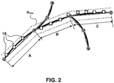
- This invention provides verification measures to verify that map matching processes undertaken in a remote device. As illustrated in Figure 2 , such verification may be completed by checking whether or not the distance between the GNSS fixes 10 and the list of road sections A, B, and C onto which these fixes are mapped is below an acceptable threshold distance dmax.
- Underlying embodiments of the invention is the concept of not carrying out the complete map matching process in a secure controller, but instead using a lightweight extra secure controller to verify, using trusted data, that the map matching process running in a host controller has been correctly executed.
- a lightweight extra secure controller to verify, using trusted data, that the map matching process running in a host controller has been correctly executed.
- the output of the map matching process i.e. the list of roads
- the submitted input data i.e. the list of GNSS coordinates.
- the portion of the system/process which is required to be secured may be made small-enough to be implemented in a secure controller, such as those found in smartcards, thereby offering high level of tamper-resistance at low cost.
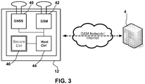
- an embodiment can be applied to a system made of a server and a remote device, and where the remote device comprises an Advanced Technologies and Oceanic Procedures (ATOP) device, as illustrated in Figure 3 .
- ATOP Advanced Technologies and Oceanic Procedures
- the ATOP is a System-in-package component that contains mainly a GPS front-end 40, a 2.5G mobile modem 42, a baseband controller 44 and a very secure tamper-resistant controller 46 similar to those found in smartcards.
- the primary application target for the ATOP in Telematics is the implementation of an OBU 12.
- the ATOP supports all the security mechanisms required to secure such a thin client OBU.
- the ATOP is the main sequencer (or host controller) of the OBU 12.
- the ATOP collects the GPS data at regular intervals (step 410) and finds the best matching road sections (step 420), using information containing in the regular Map database 48.
- the result of this map matching process is a list of road section IDs, or similar.
- the secure controller 46 first checks the integrity of submitted GNSS data (step 430), using techniques generally known in the art.
- the secure controller 46 may verify that the GNSS data has been collected at regular intervals, and that the distance and timestamp delay between two subsequent GNSS fixes of the GNSS data is below a threshold value.
- the secure controller will then undertake the step 440 of verifying, (a) that the submitted list of road sections IDs are indeed connected to each other (and connected to previously submitted road sections IDs), and (b) whether this list of road sections IDs correspond to the GNSS data. For this purpose it has access to a dedicated set of trusted data stored in a Verification Map database 50, which in turn is stored in the secure controller 46. In other words, the secure controller executes a mini process as mirror to the map matching process to check whether or not the results are consistent. If the results are not consistent with those expected, there is evidence of tampering of the remote process.
- step 440 If the verification (of step 440) succeeds, then the secure controller 46 computes, with the help of a database of fare data 52 securely stored in the secure controller, the cost that corresponds to the list of road IDs submitted to the secure controller 46 (step 450).
- the secure controller notifies its internal fraud manager in step 460.
- the system is designed such that any notification to the fraud manager is always forwarded (either instantly or at regular/random intervals) to the server 4, and is this is done so in a secure way.
- the server 4 can then take appropriate action.
- step 450 the total cost (or charging information) is signed by the secure controller 46 to indicate that the cost has been securely computed, and this signed cost is then forwarded to the server in step 460.
- the server then aggregates all costs for a given car after proper verification of their validity (step 470), and proceeds with the billing (step 480).
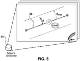
- the main purpose of the Verify Map Matching process is to verify (a) the continuity of submitted road sections, and (b) that the submitted list of GNSS fixes are indeed mapped to the submitted path (identified as a list of road section IDs).
- the process has access to a secure database 58 (illustrated in Figure 5 ) that contains, for each road section 56 (identified by a unique identifier ID):
- the map matching process (step 420") running in the host controller is modified to also provide to the secure controller 46, in addition to the list of road section IDs, the corresponding list of signed verification parameters (geometric parameters, distance, cost).
- the secure controller 46 will then first verify the validity of the signature on each security parameters before using these parameters to verify the map matching process in step 440".
- the secure controller 46 uses for this purpose a signature verification key, which can either be the RP Server Public Key (or similar) if the signature algorithm is based on public-key cryptography, or a symmetric secret key (like AES or 3-DES) that is shared between the secure controller 46 and server 4.
- the impact on the host controller 44 can is minimal.
- the host controller 44 need only manage a single database of road section records, where each record is split into a pair of insecure and secure parts.
- the insecure part contains the usual information required to perform the map matching step
- the secure part contains the information required to verify the map matching step.
- a direct benefit of this solution is that the storage requirement for the secure controller 46 is drastically reduced since it doesn't need to store a database (and such a database may typically be several Megabytes (MB) in size).
- the secure controller 46 is not required to be involved an update procedure, meaning that an update of security parameters can simply be integrated in a standard mechanism that is used to update the (unsecure) map database 48, for example.
- the host controller 44 since the host controller 44 has access to the secure database 58 that will be used for the verification process, the host controller 44 can implement some extra pre-computing steps to simplify further the task of the secure controller 46 (without compromising the security).
- a purpose of the Map Matching Verification process is to verify that a given GNSS point P (Xp,yp) is indeed mapped on a given road section (as shown in Figure 7 for example).
- the actual computation steps undertaken by the secure controller 46 to verify this mapping may depend on how the road sections are geometrically represented in the secure database 58. Several variants of this representation and how the computation steps may be varied accordingly will now be detailed.
- GNSS coordinates are typically represented as a pair of spherical coordinates given by the longitude and the latitude of a point. It means that actual distance between two points (x0,y0) and (x1,y1) cannot be measured directly from these coordinates since the length of 1° longitude arc depends on the latitude. However, since road sections are very small with respect to the scale of the planet Earth, one can assume that this arc length is constant locally around the road section, and hence it suffices to apply a corrective proportional factor on the x coordinates before computing the distance.
- a road section is represented as a straight segment joining two points given by the GNSS coordinates (x 0 ,y 0 ) and (x 1 ,y 1 ).
- a given GNSS point P ( x P , y P ) is considered to be correctly mapped on a road section 60 if the distance d between this point P and the road section 60 is less than a specified threshold distance dmax.
- a 2 + B 2 are constant parameters for the given road section 60 and threshold distance dmax.
- the secure controller 46 may take into account the limited length of the actual road segment. This can be done by verifying that the projected point S (x s , y s ) is between the section vertices (x 0 ,y 0 ) and (x 1 ,y 1 ).
- this variant does not require the provision of an independent corrective proportional factor to deal with spherical coordinates, since this factor can be directly integrated in the segment parameters A, B, C and D.
- curved roads can be approximated using a succession of smaller straight segments following the original curved road.
- an option is to represent a curved road 62 using splines, and in particular cubic splines.
- the computation of the distance d requires first the determination of the point S, which is the nearest point on the spline to the GNSS fix point P. This is not necessarily a straightforward task.
- One method may be iterative, aiming at approximating more and more precisely the coordinates of the point S. Such a method is not adapted to a lightweight secure controller such as what is preferred in embodiments of the invention.
- a solution can be applied where the host controller 44 will actually assist the secure controller 46 without compromising the security. This is done in the following two steps:
- This concept of assistance from the host controller 44 can be applied in other variants in order to simplify the processing undertaken by the secure controller 46. Care must be taken, however, that such assistance does not compromise the security of the system. It is also noted that the secure controller 46 does not need to compute d max 2 since it can be pre-computed beforehand and stored as is in the secure database 58.
- This embodiment does not require an independent corrective proportional factor to deal with spherical coordinates since it can be directly integrated in the spline parameters.
- a given point P ( x P , y P ) is considered to be mapped on a given road section 64 if P is within a polygon surrounding the section.
- a given GNSS fix point P ( x P , y P ) is considered to be correctly mapped to a given road section if the given point P is inside at least one of the circles associated with the road section.
- a given point P ( x P , y P ) will be considered as mapping to the road section if the equation 6 below is satisfied: ⁇ i ⁇ 0 , ... , N ⁇ 1 : x i ⁇ x P 2 + y i ⁇ y P 2 ⁇ d i , max 2
- the secure controller must only verify that: ⁇ i ⁇ 0,... , N ⁇ 1 : ⁇
- the actual index i to use can be given by the host controller, hence reducing further the processing, without compromise of the security.
- An alternative solution may be to consider a series of rectangles (instead of squares) or rhombuses (instead of 45°-rotated square), and specify independently the length of big and small sides (big and small diagonals in the case of rhombuses).
- GNSS receivers are typically quite sensitive to the environment where the GNSS fixes are collected.
- received GNSS fixes are typically influenced by the weather conditions, by the presence of obstacles that reduce the strength of the satellite signals or prevent the reception of these signals, and also by the proximity of buildings that can reflect these signals (multipath problem).
- the net result of this sensitivity is that GNSS fixes can differ from an actual position.
- the map matching process reduces the impact of these divergences, by finding the best matching road section in the vicinity of the collected GNSS fixes.
- the secure controller 46 may consider such situations as fraud attempts and notify the server accordingly, whereas actually they are due to bad reception conditions. It is therefore preferable to address this issue, since a high rate of false positives is unacceptable. Three mechanisms designed to address this issue will now be described below, all of which maintain the privacy-preserving property of the client OBU.
- the secure controller will actually perform statistics on the result of the map matching process.
- the secure controller 46 maintains a trip average percentage of successful verification. This trip average is transmitted along with the cost information for a given trip to the server 4. The server 4 can then take appropriate measures if such percentage is below a specified threshold value. Alternatively, the secure controller 46 may also notify an internal fraud notification manager if such percentage is below the given threshold. In this case, the fraud notification may, besides notifying the server 4, also inform a user (such as a driver of a vehicle housing the OBU) that a problem has been detected and that a predetermined person or organisation should be contacted.
- a user such as a driver of a vehicle housing the OBU
- the secure controller 46 also maintains a moving percentage of successful verification over the last N submitted verification requests. In the case this value falls below a threshold value, the secure controller 46 notifies a fraud manager as described above.
- GNSS reliability information in the secure map database 58. Since part of the mismatch between a GNSS fix and the actual vehicle position is due to the road or urban infrastructure, which is constant for a given road section. The impact of the infrastructure can be estimated or measured, and the secure data for each road section can be completed with this information.
- the distance threshold dmax can be defined for each road section separately, taking into account the influence of the surrounding infrastructure.
- the distance is increased in zones of typical bad reception, and decreased in zones of good reception in order to obtain the best detection sensitivity.
- the secure database may also contain a reliability factor for each road section, which will moderate the effect of a failed verification on the success percentage described in the previous mechanism.
- the third mechanism deals with the issue of lost of signal reception.
- the secure controller 46 will detect that there is an interruption between two GNSS fixes (for instance by observing that the distance between two such fixes are too big, or that the timestamp of each fix is above a given threshold). Instead of notifying a fraud manager immediately, the secure controller 46 can also maintain statistics on such interruptions.
- the secure controller 46 can maintain a history of such signal loss per trip, ie. the number of losses, the interruption distance and delay, and optionally time of occurrence (time of last valid fix before interruption). The complete history can then be transmitted to the server 4 along with the cost information for a given trip, or alternatively the secure controller 46 may only transmit a set of statistic values (average, accumulation, standard-deviation). In the case of abnormally big interruption, the secure controller may trigger the fraud manager, which then contact the server immediately, and/or notify the driver accordingly.
- the secure database 58 may contain extra information that specifies the location and geometric information of zones that are more susceptible to signal losses (tunnels, forests). In case of signal loss, this information is used by the secure controller to verify that the last received GNSS fix and the next first valid GNSS fix is indeed in a region identified as being prone to signal loss, and adapt the statistics accordingly (for example, by maintaining separate statistics of losses in clear areas and those in obstructed areas).
- the secure controller 46 has no means to verify that a submitted GNSS fix is not on a tolled segment or within a tolled region. Indeed, some road sections or zones can be within private areas that are not subject to tolling. An attacker could then modify the process running on the host controller 44 to transmit (albeit correct) GNSS fixes to the secure controller and inform the secure controller that there is no matching tolled road section.
- the secure controller 46 can enforce the collection of GNSS fixes at regular intervals, and detect when GNSS fixes are missing. This can be done, for instance, by checking that the distance between two subsequent GNSS fixes and the delay between two GNSS timestamps are both below a maximum value. In case of abnormal interruption of GNSS transmission, the secure controller notifies the internal fraud manager.
- the secure database can be implemented so that all un-tolled zones are covered by appropriate toll free zones.
- Such toll free zones (represented using polygon shapes for example) are added such that a given point at any location is either included in a tolled zone/section or in a toll free zone, and such that toll free zone do not overlap tolled zones (or at least only by a negligible amount).
- the secure controller 46 can verify that each regularly collected GNSS fix is indeed associated with a zone/section, either tolled or toll-free. Due to complete but disjoint coverage by tolled and toll-free zones, it is not possible for a hacked host controller to pretend that a given GNSS fix is not in a tolled zone when it is actually within a tolled zone, since the host controller will not be able to provide the toll-free zone corresponding to the submitted GNSS fix.
- the invention has been described in connection with single frequency GPS, but other GNSS systems (GLONASS, Galileo etc) would be similar. Indeed the techniques could also be applied to multiple frequency systems, with appropriate means of capturing the IF data from each carrier.
- GLONASS Globalstar Satellite System
- Galileo Galileo
Landscapes
- Engineering & Computer Science (AREA)
- Remote Sensing (AREA)
- Radar, Positioning & Navigation (AREA)
- Business, Economics & Management (AREA)
- Physics & Mathematics (AREA)
- General Physics & Mathematics (AREA)
- Finance (AREA)
- Computer Security & Cryptography (AREA)
- Accounting & Taxation (AREA)
- Computer Networks & Wireless Communication (AREA)
- Automation & Control Theory (AREA)
- Economics (AREA)
- Development Economics (AREA)
- Signal Processing (AREA)
- Strategic Management (AREA)
- General Business, Economics & Management (AREA)
- Theoretical Computer Science (AREA)
- Computing Systems (AREA)
- Computer Hardware Design (AREA)
- General Engineering & Computer Science (AREA)
- Traffic Control Systems (AREA)
- Navigation (AREA)
- Position Fixing By Use Of Radio Waves (AREA)
Claims (14)
- Positionsverfolgungseinheit (12) zur Verwendung mit einem podsiotionsbasierten Servicesystem, umfassend:einen Navigationsempfänger (1), der dazu angepasst ist, eine Positionsverfolgungsfunktion zu implementieren;ein erstes Datenverarbeitungsmittel (44), das dazu angepasst ist, eine besetzte Position gemäß einem ersten Positionsabgleichprozess (420) zu bestimmen, wobei der erste Positionsabgleichprozess Navigationsdaten von dem Navigationsempfänger und einen ersten Satz geografischer Daten (48) verwendet; undgekennzeichnet durch ein zweites Datenverarbeitungsmittel (46), das ein sicheres Datenverarbeitungsmittel ist, das dazu angepasst ist, die Integrität des ersten Positionsabgleichprozesses basierend auf einem zweiten Positionsabgleichprozess unter Verwendung der Navigationsdaten und eines zweiten Satzes geografischer Daten (50) zu verifizieren;wobei das zweite Datenverarbeitungsmittel ferner dazu angepasst ist, die Integrität des ersten Positionsabgleichprozesses basierend auf mindestens einem von Folgendem zu verifizieren:Navigationsdatenzuverlässigkeitsinformationen; historischen Informationen in Bezug auf die Rate einer erfolgreichen Integritätsverifizierung; und Informationen in Bezug auf die Unterbrechung von Daten aus den empfangenen Navigationsdaten.
- Einheit nach Anspruch 1, wobei die Einheit eine entfernte Vorrichtung ist, die eine fahrzeugmontierte Einheit ist und ferner Kommunikationsmittel umfasst, die dazu angepasst sind, mit einem Server (4) zu kommunizieren, der entfernt von der Positionsverfolgungseinheit angeordnet ist.
- Einheit nach einem der vorhergehenden Ansprüche, ferner umfassend sichere Datenspeichermittel, die dazu angepasst sind, den zweiten Satz geografischer Daten gemäß einem Verschlüsselungsalgorithmus zu speichern.
- Einheit nach einem der vorhergehenden Ansprüche,
wobei die geografischen Daten Informationen in Bezug auf die Position von Straßenabschnitten umfassen. - Einheit nach Anspruch 4, wobei ein Straßenabschnitt als mindestens eines der Folgenden dargestellt ist: eine gerade Linie, die zwei verschiedene Positionen verbindet; eine Vielzahl von Splines; ein Polygon; eine Reihe überlappender Kreise; und eine Reihe überlappender Polygone.
- Einheit nach einem der vorhergehenden Ansprüche, wobei die Datenverarbeitungsmittel ferner dazu angepasst sind, mindestens einen Betrugsbekämpfungsprozess durch Folgendes zu implementieren: Überwachen der Ordnungsmäßigkeit der Navigationsdaten; und Verifizieren, dass eine bestimmte besetzte Position mit den geografischen Daten in Zusammenhang steht.
- System zum Implementieren eines positionsbasierten Dienstes, das eine Positionsverfolgungseinheit nach einem der vorhergehenden Ansprüche umfasst.
- System nach Anspruch 7, wobei das System ein Straßenmautsystem ist.
- Verfahren zum Implementieren einer Positionsverfolgungsfunktion in einer Positionsverfolgungseinheit (12), wobei das Verfahren Folgendes umfasst:Bestimmen einer besetzten Position nach einem ersten Positionsabgleichprozess (420) durch das erste Datenverarbeitungsmittel (44), wobei der erste Positionsabgleichprozess Navigationsdaten von einem Navigationsempfänger (1) und einen ersten Satz geografischer Daten (48) verwendet;gekennzeichnet durch Verifizieren der Integrität des ersten Positionsabgleichprozesses basierend auf einem zweiten Positionsabgleich unter Verwendung von Navigationsdaten und eines zweiten Satzes geografischer Daten (50) durch das zweite Datenverarbeitungsmittel (46), das ein sicheres Datenverarbeitungsmittel ist,wobei der Schritt des Verifizierens ferner auf mindestens einem von Folgendem basiert:Navigationsdatenzuverlässigkeitsinformationen; historischen Informationen in Bezug auf die Rate einer erfolgreichen Integritätsverifizierung; und Informationen in Bezug auf die Unterbrechung von Daten aus den empfangenen Navigationsdaten.
- Verfahren nach Anspruch 9, ferner umfassend den Schritt:Implementieren mindestens eines Betrugsbekämpfungsprozesses durch: Überwachen der Ordnungsmäßigkeit der Navigationsdaten; und Verifizieren, dass eine bestimmte besetzte Position mit den geografischen Daten in Zusammenhang steht.
- Verfahren nach Anspruch 9 oder 10, wobei der Schritt des Verifizierens Folgendes umfasst:Bestimmen, ob die bestimmte besetzte Position mit den Navigationsdaten und dem zweiten Satz geografischer Daten konsistent ist oder nicht.
- Verfahren nach einem der Ansprüche 9 bis 11, wobei der Schritt des Bestimmens einer besetzten Position die folgenden Schritte umfasst:Ableiten von Positionsinformationen aus den Navigationsdaten;Bestimmen einer Entfernung von einer Position basierend auf den Positionsinformationen und dem ersten Satz geografischer Daten;Bestimmen, dass die Position die besetzte position ist, wenn der Abstand kleiner als ein Schwellenwert ist.
- Computerprogramm, umfassend Computerprogrammcodemittel, die dazu angepasst sind, alle Schritte nach einem der Ansprüche 9 bis 12 durchzuführen, wenn das Programm auf einem Computer ausgeführt wird.
- Einheit nach Anspruch 1, wobei das zweite Datenverarbeitungsmittel (46) eine sichere Steuerung in einer Chipkarte ist.
Priority Applications (1)
| Application Number | Priority Date | Filing Date | Title |
|---|---|---|---|
| EP09806129.4A EP2316004B1 (de) | 2008-08-22 | 2009-08-21 | Standortbasierte dienste |
Applications Claiming Priority (3)
| Application Number | Priority Date | Filing Date | Title |
|---|---|---|---|
| EP08105105 | 2008-08-22 | ||
| EP09806129.4A EP2316004B1 (de) | 2008-08-22 | 2009-08-21 | Standortbasierte dienste |
| PCT/IB2009/053695 WO2010020966A2 (en) | 2008-08-22 | 2009-08-21 | Location-based services |
Publications (2)
| Publication Number | Publication Date |
|---|---|
| EP2316004A2 EP2316004A2 (de) | 2011-05-04 |
| EP2316004B1 true EP2316004B1 (de) | 2019-02-20 |
Family
ID=41707527
Family Applications (1)
| Application Number | Title | Priority Date | Filing Date |
|---|---|---|---|
| EP09806129.4A Not-in-force EP2316004B1 (de) | 2008-08-22 | 2009-08-21 | Standortbasierte dienste |
Country Status (4)
| Country | Link |
|---|---|
| US (2) | US9534907B2 (de) |
| EP (1) | EP2316004B1 (de) |
| CN (1) | CN102124301B (de) |
| WO (1) | WO2010020966A2 (de) |
Families Citing this family (17)
| Publication number | Priority date | Publication date | Assignee | Title |
|---|---|---|---|---|
| WO2010020968A1 (en) * | 2008-08-22 | 2010-02-25 | Nxp B.V. | Verification of process integrity |
| EP2348444B1 (de) | 2009-12-16 | 2014-03-19 | Nxp B.V. | Datenverarbeitungsvorrichtung |
| US9261375B2 (en) * | 2010-04-01 | 2016-02-16 | International Business Machines Corporation | Anomaly detection for road user charging systems |
| EP2498225B1 (de) | 2011-03-11 | 2014-12-17 | Telit Automotive Solutions NV | Straßenmautsystem und Verfahren |
| CN103136959B (zh) * | 2011-11-25 | 2015-03-11 | 北京中交兴路信息科技有限公司 | 在移动目标监控中聚合展示移动目标信息的方法 |
| US9286266B1 (en) * | 2012-05-04 | 2016-03-15 | Left Lane Network, Inc. | Cloud computed data service for automated reporting of vehicle trip data and analysis |
| ES2670597T3 (es) * | 2012-10-04 | 2018-05-31 | Cintra Infraestructuras, S.A. | Sistema y método para la determinación de la posición de un área de control |
| US20140278838A1 (en) * | 2013-03-14 | 2014-09-18 | Uber Technologies, Inc. | Determining an amount for a toll based on location data points provided by a computing device |
| NO336505B1 (no) * | 2013-12-20 | 2015-09-14 | Q Free Asa | Sonedeteksjon i et GNSS-system |
| DE102014017083A1 (de) * | 2014-11-19 | 2016-05-19 | Elektrobit Automotive Gmbh | Technik zum Abgleichen erfasster Positionen mit digitalem Kartenmaterial |
| CN105513146A (zh) * | 2015-12-14 | 2016-04-20 | 四川长虹电器股份有限公司 | 高速公路自助通行系统中app位置心跳管理系统 |
| CN112857376A (zh) * | 2021-01-12 | 2021-05-28 | 广州小鹏自动驾驶科技有限公司 | 一种车辆道路匹配的方法和装置 |
| DE102022001573A1 (de) | 2022-05-04 | 2023-07-13 | Mercedes-Benz Group AG | Verfahren zum Protokollieren einer Fahrtstrecke eines Kraftwagens mittels eines Fahrtenbuchsystems |
| US12579662B2 (en) | 2023-06-15 | 2026-03-17 | Oracle International Corporation | High-precision localization of a moving object on a trajectory |
| US20250085434A1 (en) * | 2023-09-12 | 2025-03-13 | Oracle International Corporation | Preparing data for high-precision absolute localization of a moving object along a trajectory |
| US12562040B2 (en) | 2023-09-29 | 2026-02-24 | Bank Of America Corporation | System and method to detect device during ambient sensors |
| FR3158004A1 (fr) * | 2023-12-27 | 2025-07-04 | Ampere Sas | Procédé de communication sécurisée entre un système embarqué et un réseau externe |
Family Cites Families (17)
| Publication number | Priority date | Publication date | Assignee | Title |
|---|---|---|---|---|
| US6725202B1 (en) * | 1995-04-10 | 2004-04-20 | Texas Instruments Incorporated | Transaction accounting of toll transactions in transponder systems |
| USRE38626E1 (en) * | 1997-03-14 | 2004-10-19 | Visionary Technology, Inc. | Parking regulation enforcement system |
| EP1050853A4 (de) * | 1998-01-23 | 2006-05-10 | Toyota Motor Co Ltd | Vorrichtung, system, und karte zur buchhaltung |
| CA2335182C (en) * | 1998-06-18 | 2008-01-29 | Mannesmann Ag | Roadside control device for a toll apparatus installed in a motor vehicle |
| US6469664B1 (en) * | 1999-10-05 | 2002-10-22 | Honeywell International Inc. | Method, apparatus, and computer program products for alerting surface vessels to hazardous conditions |
| DE60119062T2 (de) * | 2000-10-31 | 2006-11-30 | Matsushita Electric Industrial Co., Ltd., Kadoma | Navigationsvorrichtung |
| US6600418B2 (en) * | 2000-12-12 | 2003-07-29 | 3M Innovative Properties Company | Object tracking and management system and method using radio-frequency identification tags |
| US20060200379A1 (en) * | 2001-01-31 | 2006-09-07 | Werner Biet | Road toll collection system |
| JP2005503434A (ja) | 2001-09-21 | 2005-02-03 | エフ.ホフマン−ラ ロシュ アーゲー | 3−デスオキシ−ビタミンd3類似体 |
| US7219032B2 (en) * | 2002-04-20 | 2007-05-15 | John Louis Spiesberger | Estimation algorithms and location techniques |
| CA2501153A1 (en) * | 2002-10-25 | 2004-05-06 | Yoshiaki Takida | Toll road charge collection system using artificial satellite, charge collecting machine, and charge collecting method |
| JP2005140521A (ja) * | 2003-11-04 | 2005-06-02 | Pioneer Electronic Corp | 交通状況報知装置、そのシステム、その方法、そのプログラム、および、そのプログラムを記録した記録媒体 |
| GB0423793D0 (en) * | 2004-10-27 | 2004-12-01 | Ibm | A method and system for gathering and processing data for road use charging |
| US20080170074A1 (en) * | 2005-08-19 | 2008-07-17 | Daimler Ag | Method For Generating a Map Depiction For Optimal Perceptibility of Streets to Travel Through |
| GB0523513D0 (en) * | 2005-11-18 | 2005-12-28 | Applied Generics Ltd | Efficient location and tracking of mobile subscribers |
| US7841249B2 (en) * | 2006-07-10 | 2010-11-30 | Southwest Research Institute | Fluidized sensor for mapping a pipeline |
| US8384560B2 (en) * | 2008-03-11 | 2013-02-26 | Kapsch Trafficcom Ivhs Inc. | Real-time vehicle position determination using communications with variable latency |
-
2009
- 2009-08-21 CN CN200980132330.3A patent/CN102124301B/zh not_active Expired - Fee Related
- 2009-08-21 WO PCT/IB2009/053695 patent/WO2010020966A2/en not_active Ceased
- 2009-08-21 US US13/059,402 patent/US9534907B2/en not_active Expired - Fee Related
- 2009-08-21 EP EP09806129.4A patent/EP2316004B1/de not_active Not-in-force
-
2016
- 2016-12-29 US US15/393,835 patent/US10621793B2/en not_active Expired - Fee Related
Non-Patent Citations (1)
| Title |
|---|
| None * |
Also Published As
| Publication number | Publication date |
|---|---|
| CN102124301B (zh) | 2014-04-02 |
| US10621793B2 (en) | 2020-04-14 |
| WO2010020966A2 (en) | 2010-02-25 |
| CN102124301A (zh) | 2011-07-13 |
| WO2010020966A3 (en) | 2010-06-24 |
| EP2316004A2 (de) | 2011-05-04 |
| US9534907B2 (en) | 2017-01-03 |
| US20170178415A1 (en) | 2017-06-22 |
| US20110153267A1 (en) | 2011-06-23 |
Similar Documents
| Publication | Publication Date | Title |
|---|---|---|
| EP2316004B1 (de) | Standortbasierte dienste | |
| US10339725B2 (en) | Road toll system | |
| CN101911130B (zh) | 道路收费系统 | |
| USRE46915E1 (en) | Verification of process integrity | |
| US9691188B2 (en) | Tolling system and method using telecommunications | |
| EP1993076B1 (de) | Strassenbenutzungsauswertung | |
| EP2017790A2 (de) | Positionsbasierte Ladung | |
| US9595139B1 (en) | Universal tolling system and method | |
| CN111192047B (zh) | 基于非对称算法的车载单元收费方法 | |
| US10950062B2 (en) | Method and apparatus for trusted recording in a road toll system | |
| US8818895B2 (en) | Vehicle device, ad hoc network and method for a road toll system | |
| JPH10293866A (ja) | 移動体用料金処理装置 | |
| KR20030094579A (ko) | 버스궤적 추적방법 및 그 장치 | |
| WO2024214201A1 (ja) | 不正検知装置、不正検知システム、不正検知方法、及びプログラム | |
| Lahoti | Privacy-Preserving Vehicle Miles Traveled (PPVMT) tax |
Legal Events
| Date | Code | Title | Description |
|---|---|---|---|
| PUAI | Public reference made under article 153(3) epc to a published international application that has entered the european phase |
Free format text: ORIGINAL CODE: 0009012 |
|
| 17P | Request for examination filed |
Effective date: 20110322 |
|
| AK | Designated contracting states |
Kind code of ref document: A2 Designated state(s): AT BE BG CH CY CZ DE DK EE ES FI FR GB GR HR HU IE IS IT LI LT LU LV MC MK MT NL NO PL PT RO SE SI SK SM TR |
|
| DAX | Request for extension of the european patent (deleted) | ||
| 17Q | First examination report despatched |
Effective date: 20131003 |
|
| RAP1 | Party data changed (applicant data changed or rights of an application transferred) |
Owner name: TELIT AUTOMOTIVE SOLUTIONS NV |
|
| 111Z | Information provided on other rights and legal means of execution |
Free format text: AT BE BG CH CY CZ DE DK EE ES FI FR GB GR HR HU IE IS IT LT LU LV MC MK MT NL NO PL PT RO SE SI SK SM TR Effective date: 20161103 |
|
| STAA | Information on the status of an ep patent application or granted ep patent |
Free format text: STATUS: EXAMINATION IS IN PROGRESS |
|
| GRAP | Despatch of communication of intention to grant a patent |
Free format text: ORIGINAL CODE: EPIDOSNIGR1 |
|
| STAA | Information on the status of an ep patent application or granted ep patent |
Free format text: STATUS: GRANT OF PATENT IS INTENDED |
|
| INTG | Intention to grant announced |
Effective date: 20180828 |
|
| GRAS | Grant fee paid |
Free format text: ORIGINAL CODE: EPIDOSNIGR3 |
|
| GRAA | (expected) grant |
Free format text: ORIGINAL CODE: 0009210 |
|
| STAA | Information on the status of an ep patent application or granted ep patent |
Free format text: STATUS: THE PATENT HAS BEEN GRANTED |
|
| RIN1 | Information on inventor provided before grant (corrected) |
Inventor name: PEETERS, MICHAEL Inventor name: DEBAST, CLAUDE Inventor name: FROIDCOEUR, TIM |
|
| AK | Designated contracting states |
Kind code of ref document: B1 Designated state(s): AT BE BG CH CY CZ DE DK EE ES FI FR GB GR HR HU IE IS IT LI LT LU LV MC MK MT NL NO PL PT RO SE SI SK SM TR |
|
| REG | Reference to a national code |
Ref country code: GB Ref legal event code: FG4D |
|
| REG | Reference to a national code |
Ref country code: CH Ref legal event code: EP |
|
| REG | Reference to a national code |
Ref country code: DE Ref legal event code: R096 Ref document number: 602009057093 Country of ref document: DE |
|
| REG | Reference to a national code |
Ref country code: AT Ref legal event code: REF Ref document number: 1098781 Country of ref document: AT Kind code of ref document: T Effective date: 20190315 |
|
| REG | Reference to a national code |
Ref country code: IE Ref legal event code: FG4D |
|
| REG | Reference to a national code |
Ref country code: LT Ref legal event code: MG4D |
|
| REG | Reference to a national code |
Ref country code: NL Ref legal event code: MP Effective date: 20190220 |
|
| PG25 | Lapsed in a contracting state [announced via postgrant information from national office to epo] |
Ref country code: PT Free format text: LAPSE BECAUSE OF FAILURE TO SUBMIT A TRANSLATION OF THE DESCRIPTION OR TO PAY THE FEE WITHIN THE PRESCRIBED TIME-LIMIT Effective date: 20190620 Ref country code: SE Free format text: LAPSE BECAUSE OF FAILURE TO SUBMIT A TRANSLATION OF THE DESCRIPTION OR TO PAY THE FEE WITHIN THE PRESCRIBED TIME-LIMIT Effective date: 20190220 Ref country code: LT Free format text: LAPSE BECAUSE OF FAILURE TO SUBMIT A TRANSLATION OF THE DESCRIPTION OR TO PAY THE FEE WITHIN THE PRESCRIBED TIME-LIMIT Effective date: 20190220 Ref country code: NO Free format text: LAPSE BECAUSE OF FAILURE TO SUBMIT A TRANSLATION OF THE DESCRIPTION OR TO PAY THE FEE WITHIN THE PRESCRIBED TIME-LIMIT Effective date: 20190520 Ref country code: FI Free format text: LAPSE BECAUSE OF FAILURE TO SUBMIT A TRANSLATION OF THE DESCRIPTION OR TO PAY THE FEE WITHIN THE PRESCRIBED TIME-LIMIT Effective date: 20190220 |
|
| PG25 | Lapsed in a contracting state [announced via postgrant information from national office to epo] |
Ref country code: IS Free format text: LAPSE BECAUSE OF FAILURE TO SUBMIT A TRANSLATION OF THE DESCRIPTION OR TO PAY THE FEE WITHIN THE PRESCRIBED TIME-LIMIT Effective date: 20190620 Ref country code: BG Free format text: LAPSE BECAUSE OF FAILURE TO SUBMIT A TRANSLATION OF THE DESCRIPTION OR TO PAY THE FEE WITHIN THE PRESCRIBED TIME-LIMIT Effective date: 20190520 Ref country code: LV Free format text: LAPSE BECAUSE OF FAILURE TO SUBMIT A TRANSLATION OF THE DESCRIPTION OR TO PAY THE FEE WITHIN THE PRESCRIBED TIME-LIMIT Effective date: 20190220 Ref country code: NL Free format text: LAPSE BECAUSE OF FAILURE TO SUBMIT A TRANSLATION OF THE DESCRIPTION OR TO PAY THE FEE WITHIN THE PRESCRIBED TIME-LIMIT Effective date: 20190220 Ref country code: HR Free format text: LAPSE BECAUSE OF FAILURE TO SUBMIT A TRANSLATION OF THE DESCRIPTION OR TO PAY THE FEE WITHIN THE PRESCRIBED TIME-LIMIT Effective date: 20190220 Ref country code: GR Free format text: LAPSE BECAUSE OF FAILURE TO SUBMIT A TRANSLATION OF THE DESCRIPTION OR TO PAY THE FEE WITHIN THE PRESCRIBED TIME-LIMIT Effective date: 20190521 |
|
| REG | Reference to a national code |
Ref country code: AT Ref legal event code: MK05 Ref document number: 1098781 Country of ref document: AT Kind code of ref document: T Effective date: 20190220 |
|
| PG25 | Lapsed in a contracting state [announced via postgrant information from national office to epo] |
Ref country code: CZ Free format text: LAPSE BECAUSE OF FAILURE TO SUBMIT A TRANSLATION OF THE DESCRIPTION OR TO PAY THE FEE WITHIN THE PRESCRIBED TIME-LIMIT Effective date: 20190220 Ref country code: RO Free format text: LAPSE BECAUSE OF FAILURE TO SUBMIT A TRANSLATION OF THE DESCRIPTION OR TO PAY THE FEE WITHIN THE PRESCRIBED TIME-LIMIT Effective date: 20190220 Ref country code: IT Free format text: LAPSE BECAUSE OF FAILURE TO SUBMIT A TRANSLATION OF THE DESCRIPTION OR TO PAY THE FEE WITHIN THE PRESCRIBED TIME-LIMIT Effective date: 20190220 Ref country code: SK Free format text: LAPSE BECAUSE OF FAILURE TO SUBMIT A TRANSLATION OF THE DESCRIPTION OR TO PAY THE FEE WITHIN THE PRESCRIBED TIME-LIMIT Effective date: 20190220 Ref country code: DK Free format text: LAPSE BECAUSE OF FAILURE TO SUBMIT A TRANSLATION OF THE DESCRIPTION OR TO PAY THE FEE WITHIN THE PRESCRIBED TIME-LIMIT Effective date: 20190220 Ref country code: EE Free format text: LAPSE BECAUSE OF FAILURE TO SUBMIT A TRANSLATION OF THE DESCRIPTION OR TO PAY THE FEE WITHIN THE PRESCRIBED TIME-LIMIT Effective date: 20190220 Ref country code: ES Free format text: LAPSE BECAUSE OF FAILURE TO SUBMIT A TRANSLATION OF THE DESCRIPTION OR TO PAY THE FEE WITHIN THE PRESCRIBED TIME-LIMIT Effective date: 20190220 |
|
| REG | Reference to a national code |
Ref country code: DE Ref legal event code: R097 Ref document number: 602009057093 Country of ref document: DE |
|
| PG25 | Lapsed in a contracting state [announced via postgrant information from national office to epo] |
Ref country code: SM Free format text: LAPSE BECAUSE OF FAILURE TO SUBMIT A TRANSLATION OF THE DESCRIPTION OR TO PAY THE FEE WITHIN THE PRESCRIBED TIME-LIMIT Effective date: 20190220 Ref country code: PL Free format text: LAPSE BECAUSE OF FAILURE TO SUBMIT A TRANSLATION OF THE DESCRIPTION OR TO PAY THE FEE WITHIN THE PRESCRIBED TIME-LIMIT Effective date: 20190220 |
|
| PLBE | No opposition filed within time limit |
Free format text: ORIGINAL CODE: 0009261 |
|
| STAA | Information on the status of an ep patent application or granted ep patent |
Free format text: STATUS: NO OPPOSITION FILED WITHIN TIME LIMIT |
|
| PG25 | Lapsed in a contracting state [announced via postgrant information from national office to epo] |
Ref country code: AT Free format text: LAPSE BECAUSE OF FAILURE TO SUBMIT A TRANSLATION OF THE DESCRIPTION OR TO PAY THE FEE WITHIN THE PRESCRIBED TIME-LIMIT Effective date: 20190220 |
|
| 26N | No opposition filed |
Effective date: 20191121 |
|
| PG25 | Lapsed in a contracting state [announced via postgrant information from national office to epo] |
Ref country code: SI Free format text: LAPSE BECAUSE OF FAILURE TO SUBMIT A TRANSLATION OF THE DESCRIPTION OR TO PAY THE FEE WITHIN THE PRESCRIBED TIME-LIMIT Effective date: 20190220 |
|
| PG25 | Lapsed in a contracting state [announced via postgrant information from national office to epo] |
Ref country code: TR Free format text: LAPSE BECAUSE OF FAILURE TO SUBMIT A TRANSLATION OF THE DESCRIPTION OR TO PAY THE FEE WITHIN THE PRESCRIBED TIME-LIMIT Effective date: 20190220 |
|
| PG25 | Lapsed in a contracting state [announced via postgrant information from national office to epo] |
Ref country code: LU Free format text: LAPSE BECAUSE OF NON-PAYMENT OF DUE FEES Effective date: 20190821 Ref country code: CH Free format text: LAPSE BECAUSE OF NON-PAYMENT OF DUE FEES Effective date: 20190831 Ref country code: LI Free format text: LAPSE BECAUSE OF NON-PAYMENT OF DUE FEES Effective date: 20190831 Ref country code: MC Free format text: LAPSE BECAUSE OF FAILURE TO SUBMIT A TRANSLATION OF THE DESCRIPTION OR TO PAY THE FEE WITHIN THE PRESCRIBED TIME-LIMIT Effective date: 20190220 |
|
| REG | Reference to a national code |
Ref country code: BE Ref legal event code: MM Effective date: 20190831 |
|
| PG25 | Lapsed in a contracting state [announced via postgrant information from national office to epo] |
Ref country code: IE Free format text: LAPSE BECAUSE OF NON-PAYMENT OF DUE FEES Effective date: 20190821 |
|
| PG25 | Lapsed in a contracting state [announced via postgrant information from national office to epo] |
Ref country code: BE Free format text: LAPSE BECAUSE OF NON-PAYMENT OF DUE FEES Effective date: 20190831 |
|
| PG25 | Lapsed in a contracting state [announced via postgrant information from national office to epo] |
Ref country code: CY Free format text: LAPSE BECAUSE OF FAILURE TO SUBMIT A TRANSLATION OF THE DESCRIPTION OR TO PAY THE FEE WITHIN THE PRESCRIBED TIME-LIMIT Effective date: 20190220 |
|
| PG25 | Lapsed in a contracting state [announced via postgrant information from national office to epo] |
Ref country code: MT Free format text: LAPSE BECAUSE OF FAILURE TO SUBMIT A TRANSLATION OF THE DESCRIPTION OR TO PAY THE FEE WITHIN THE PRESCRIBED TIME-LIMIT Effective date: 20190220 Ref country code: HU Free format text: LAPSE BECAUSE OF FAILURE TO SUBMIT A TRANSLATION OF THE DESCRIPTION OR TO PAY THE FEE WITHIN THE PRESCRIBED TIME-LIMIT; INVALID AB INITIO Effective date: 20090821 |
|
| PGFP | Annual fee paid to national office [announced via postgrant information from national office to epo] |
Ref country code: FR Payment date: 20210819 Year of fee payment: 13 |
|
| REG | Reference to a national code |
Ref country code: GB Ref legal event code: 732E Free format text: REGISTERED BETWEEN 20220120 AND 20220126 |
|
| REG | Reference to a national code |
Ref country code: DE Ref legal event code: R081 Ref document number: 602009057093 Country of ref document: DE Owner name: TITAN INTELLIGENCE TECHNOLOGY LIMITED, HK Free format text: FORMER OWNER: TELIT AUTOMOTIVE SOLUTIONS NV, LEUVEN, BE |
|
| REG | Reference to a national code |
Ref country code: DE Ref legal event code: R081 Ref document number: 602009057093 Country of ref document: DE Owner name: TITAN INTELLIGENCE TECHNOLOGY LIMITED, HK Free format text: FORMER OWNER: TITAN AUTOMOTIVE SOLUTIONS, LEUVEN, BE |
|
| PG25 | Lapsed in a contracting state [announced via postgrant information from national office to epo] |
Ref country code: MK Free format text: LAPSE BECAUSE OF FAILURE TO SUBMIT A TRANSLATION OF THE DESCRIPTION OR TO PAY THE FEE WITHIN THE PRESCRIBED TIME-LIMIT Effective date: 20190220 |
|
| PGFP | Annual fee paid to national office [announced via postgrant information from national office to epo] |
Ref country code: GB Payment date: 20221027 Year of fee payment: 14 Ref country code: DE Payment date: 20221027 Year of fee payment: 14 |
|
| PG25 | Lapsed in a contracting state [announced via postgrant information from national office to epo] |
Ref country code: FR Free format text: LAPSE BECAUSE OF NON-PAYMENT OF DUE FEES Effective date: 20220831 |
|
| REG | Reference to a national code |
Ref country code: DE Ref legal event code: R119 Ref document number: 602009057093 Country of ref document: DE |
|
| GBPC | Gb: european patent ceased through non-payment of renewal fee |
Effective date: 20230821 |
|
| PG25 | Lapsed in a contracting state [announced via postgrant information from national office to epo] |
Ref country code: GB Free format text: LAPSE BECAUSE OF NON-PAYMENT OF DUE FEES Effective date: 20230821 |
|
| PG25 | Lapsed in a contracting state [announced via postgrant information from national office to epo] |
Ref country code: GB Free format text: LAPSE BECAUSE OF NON-PAYMENT OF DUE FEES Effective date: 20230821 Ref country code: DE Free format text: LAPSE BECAUSE OF NON-PAYMENT OF DUE FEES Effective date: 20240301 |