EP2259643B1 - Method for transmitting position information by a mobile device - Google Patents
Method for transmitting position information by a mobile device Download PDFInfo
- Publication number
- EP2259643B1 EP2259643B1 EP10157816.9A EP10157816A EP2259643B1 EP 2259643 B1 EP2259643 B1 EP 2259643B1 EP 10157816 A EP10157816 A EP 10157816A EP 2259643 B1 EP2259643 B1 EP 2259643B1
- Authority
- EP
- European Patent Office
- Prior art keywords
- mobile device
- information
- position information
- pseudo
- successive
- Prior art date
- Legal status (The legal status is an assumption and is not a legal conclusion. Google has not performed a legal analysis and makes no representation as to the accuracy of the status listed.)
- Active
Links
Images


Classifications
-
- G—PHYSICS
- G01—MEASURING; TESTING
- G01S—RADIO DIRECTION-FINDING; RADIO NAVIGATION; DETERMINING DISTANCE OR VELOCITY BY USE OF RADIO WAVES; LOCATING OR PRESENCE-DETECTING BY USE OF THE REFLECTION OR RERADIATION OF RADIO WAVES; ANALOGOUS ARRANGEMENTS USING OTHER WAVES
- G01S5/00—Position-fixing by co-ordinating two or more direction or position line determinations; Position-fixing by co-ordinating two or more distance determinations
- G01S5/0009—Transmission of position information to remote stations
- G01S5/0018—Transmission from mobile station to base station
- G01S5/0027—Transmission from mobile station to base station of actual mobile position, i.e. position determined on mobile
Definitions
- the present invention relates to a method of transmitting position information by a mobile device. It applies in particular to the field of road, motorway and urban toll collection systems and to any other location-based payment device, as well as to devices for storing and / or transmitting position information periodically.
- the vehicle In all the tracking systems of a mobile device such as a vehicle or a fleet of vehicles, it is known, particularly from the document US 2006/079244 that the vehicle periodically transmits information concerning its position to a central server.
- the period of transmission depends on the type of application that uses this information. For applications that need to transmit this information very often with a low period of the order of a few seconds, or even a second, the vehicle generally transmits its position by a telecommunication means, for example of the cellular network or satellite type .
- the transmission of the position information is generally performed in the form of sending a triplet of data relating to the latitude, longitude and altitude of the vehicle in a predetermined coordinate system.
- the position information can also be transmitted as a set of pseudo-distances between the mobile device and reference points, the reference points being satellites in the case of using a navigation system by GNSS satellite (in English: Global Navigation Satellite System).
- GNSS satellite in English: Global Navigation Satellite System
- 3GPP in English: Third Generation Partnership Project
- each of the position data is coded in 32-bit binary which implies a bit rate equal to three times 32 bits to be transmitted per second and per vehicle when the position information is relative to latitude, longitude and altitude and the transmission period is one second.
- the object of the invention is to solve these problems and to propose a method for transmitting position information carried by a mobile device that does not have the drawbacks of the known solutions and that makes it possible to limit the volume of the position data to be transmitted.
- the method furthermore consists of measurements of pseudo-distances carried out at successive times t i and from absolute position information at the initial time t 0 , periodically determining, at a period Ta, absolute position information of the mobile device, the period Ta being equal to a multiple, greater than one, of the period Tv .
- the absolute position information and the position change information transmitted to the position server by the mobile device are respectively the pseudo-distance measurements acquired by the mobile device and pseudo-range variations acquired by the mobile device. calculated distances on board the mobile device, the successive positions of the mobile device being calculated by the position server.
- the absolute position information and the position variation information are respectively triplets of values corresponding to the latitude (lat), the longitude (long) and the altitude (alt) of the mobile device and variations of latitude ( ⁇ lat), longitude ( ⁇ long) and altitude ( ⁇ alt) of the mobile device.
- the absolute position information and the position variation information are real numbers comprising a number of successive significant digits of variable importance
- the method furthermore consists, for each piece of information, in selecting the significant digits as a function of an estimate of their importance and to transmit to the position server a significant number of significant digits, the estimated numbers of less importance being deleted.
- the absolute position information and the position change information are real numbers having a number of successive significant digits of variable importance
- the method further comprises, for each piece of information, selecting the significant digits as a function of an estimate of their degree of importance and coding and then transmitting all the significant digits, the estimated numbers of less importance being coded on a number of bits less than the number of bits used for the figures having a higher degree of importance.
- the method consists of transmitting an identifier of a road segment on which the mobile device is located and the absolute position information and the position variation information are respectively curvilinear abscissa and curvilinear abscissa variations of the mobile device on the road segment.
- the road segment identifier is obtained from a vector map database.
- the curvilinear abscissa and the curvilinear abscissa variations are computed and coded on board the mobile device with a binary code provided by a Huffman table stored in a vector cartographic database, or provided by the position server.
- the transmission of position information and positional change information can be performed as and when acquired by a mobile network communication system.
- the position information and position change information or can be stored in a memory on board the mobile device and transmitted globally during the passage of the mobile device near a terrestrial relay provided with a radiocommunication system.
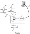
- the figures 1a and 1b represent two examples of location systems of a mobile device 1, for example a vehicle, by satellite, according to the invention.
- the locating system comprises, on board the vehicle 1, a locating and broadcasting device 2 intended to carry out measurements making it possible to determine the position and / or the speed of the vehicle and to transmit this location information to a position server 3 responsible for storing and / or exploiting them.
- the locating and broadcasting device 2 comprises a receiver 4 of GNSS navigation signals (in English: Global Navigation Satellite System) such as a GPS receiver (in English: Global Positioning System) or Galileo, issued by a satellite constellation 5a. , 5b.
- the measurements carried out on board the vehicle can be transmitted directly to the position server 3 which deduces the position information of the vehicle.
- the vehicle position information can be calculated on board the vehicle by the GNSS receiver 4 from the exploitation of signals 13a and 13b emitted by the satellites 5a, 5b.
- the number of satellites must be at least four to determine the four position coordinates of the vehicle in the space x, y, z and in time t.
- the transmission of the position information to the position server 3 can be carried out in real time as and when the acquisition of this information or alternatively, be postponed in time.
- the locating and broadcasting device 2 furthermore comprises a cell-network mobile communication transmitter-receiver 6, for example of the GSM (Global System for Mobile Communications) type, UMTS (Universal Mobile Telecommunications System) , or CDMA (in English: Division Multiple Access Code) connected to the GNSS receiver 4.
- the position information determined by the receiver 4 is then supplied to the mobile communication transceiver 6 which, according to a predetermined period depending on the application, sends said position information to the position server 3 through a communication channel 12 and via a terrestrial relay such as for example a base station 7 covering a coverage area, also called cell, in which is the mobile device 1, or a road gantry.
- a terrestrial relay such as for example a base station 7 covering a coverage area, also called cell, in which is the mobile device 1, or a road gantry.
- the position information acquired successively by the receiver 4 is stored in a memory 8 of this receiver 4 and transmitted simultaneously to the position server 3 via a local radio access point such as, for example, a Gantry-type gantry crane equipped with radiocommunication means.
- a local radio access point such as, for example, a Gantry-type gantry crane equipped with radiocommunication means.
- the delay in the transmission of position information eliminates mobile phone systems which is more economical.
- the method consists for the receiver 4 to determine the pseudo-distances d1, d2, d3 separating it from at least three satellites 5a, 5b, 5c of the constellation and then to deduce the point of intersection 14 of the spheres whose center is materialized by the position of the satellite itself and whose radius is provided by the pseudo-distances d1, d2, d3.
- the position of the GNSS receiver 4 corresponds to this point of intersection 14.
- the measurement of the pseudo-distances d1, d2, d3 is performed in the receiver 4 by timing the arrival time of radio signals constituting a navigation message from the satellites 5a, 5b, 5c.
- the essential information from each satellite via the navigation message and to be processed by the receiver is constituted by the date of transmission of the message and the position of the satellite at the time of transmission of the radio signal.
- the satellite transmits in its navigation message its ephemeris (Keplerian parameters) allowing the receiver 4, or the position server 3, to calculate the position of the satellite in a frame linked to the Earth.
- the ephemeris are constituted in the case of a GPS signal of 16 parameters repeated every 30 seconds in the navigation message.
- the position of the satellite being obtained it remains to the receiver 4, or the position server 3, to detect the time of transmission of the message in order to deduce the propagation time of the signal transmitted by the satellite and the pseudo-distance separating it of the satellite, then the radius of one of the 4 necessary spheres, and the position of the vehicle 1.
- the invention consists for each mobile vehicle 1, in a first step, to determine a first position absolute information of the vehicle at an initial time t 0 and then, in a second step, from the initial moment t 0 , to be determined periodically, information of variations of successive positions of said mobile vehicle over time between instants of consecutive measurements, for example t i and t i + Tv, i being an integer greater than 0.
- the determination of the successive positional variations is carried out at a predetermined period T v chosen according to the application concerned.
- the method preferably consists, periodically, in a period Ta equal to a multiple, greater than one, of the period Tv, absolute position information, and between each determination of absolute position information, to determine at the period Tv information of successive positional changes of said moving vehicle.
- the information of absolute positions or position variations can be calculated on board the mobile vehicle by the receiver 4 and then transmitted to the position server 3 as and when they are acquired, or stored in a memory 8 of the receiver 4 and transmitted globally via a local radio access point.
- the information of absolute positions or positional variations can be calculated by the position server 3 from measurements of pseudo-distances, or respectively variations between consecutive pseudo-distances measurements, made and transmitted directly by the receiver 4 without prior treatment.
- the pseudo-range measurements carried out by the receiver 4 correspond to the pseudo-distances which separate the vehicle from the satellites of the positioning system.
- the absolute position information determined at the period Ta are triplets of values corresponding to the lat latitude, the long longitude and the alt altitude of the vehicle, and the variations of successive positions determined at the period Tv are triplets of values corresponding to the variations of latitude ⁇ lat, longitude ⁇ long and altitude ⁇ alt of the vehicle between consecutive moments of measurement, for example t i and t i + Tv.
- the accuracy of the measurements made by the receiver 4 and the accuracy of the position information which are determined from these measurements depend on the quality of the GNSS signals received by the receiver 4 and in particular the signal-to-noise ratio received or residues to calculate the position. Consequently, the measurements taken, the absolute values corresponding to the latitude lat, the long longitude and the altitude alt of the vehicle as well as the values of variations corresponding to the variations of latitude ⁇ lat, longitude ⁇ long and altitude ⁇ alt of the vehicle between consecutive moments of measurement include a number of significant figures, the importance of which may vary.
- the invention furthermore consists in determining which are the most significant digits and, at the level of the binary coding of the information to be transmitted, assigning less importance to the less significant digits.
- the importance of the significant digits can be estimated from a measurement of the signal-to-noise ratio carried out on each received GNSS signal and taken into account in the calculation of the position.
- the relationship between the signal-to-noise ratio and an estimate of the pseudo-range measurement accuracy is known to those skilled in the art and is obtained by the relationships described hereinafter.
- the estimated non-significant figures are deleted and only the significant digits are coded and transmitted.
- all the digits are coded and transmitted but the less significant digits are coded on fewer bits than the most significant digits. The removal of figures whose reliability is questionable or their coding on a lower number of bits can greatly reduce the amount of information to be stored and transmitted.
- the information of absolute positions determined during the period Ta are two values respectively corresponding to an identifier of the road segment on which the mobile vehicle is located and the curvilinear abscissa corresponding to the position of the vehicle on said road segment .
- the variations of successive positions determined, at the period Tv, between two absolute position measurements are variations of the curvilinear abscissa of the vehicle between consecutive measurement instants, for example t i and t i + Tv.
- the identifier of the road segment on which the vehicle is located is determined by means of a vector map database for example installed in the GNSS receiver 4.
- the vector map database identifies a road segment by a point of origin and a point of arrival, which makes it possible to obtain a geometrical representation of each segment of road.
- This second embodiment of the invention makes it possible to transmit only one position information coded in binary instead of three at each measurement period Tv and to further reduce the volume of information to be transmitted to the position server 3.
- the curvilinear abscissa and the curvilinear abscissa variations are calculated on board the vehicle by the receiver 4 and encoded with a binary code depending on the road segment on which the vehicle is located prior to their transmission to the position server 3.
- This coding makes it possible to further compress the information transmitted to the server of positions.
- the binary code can for example be provided by the position server or by a Huffman table stored in a vector map base installed in the receiver 4. In the case of a coding provided by a Huffman table, to allow the decoding of the coded message transmitted by the receiver 4, the Huffman table is also stored in a memory of the position server 3.
- the transmission of coded information is performed by a radio communication means such as a terrestrial relay.
- the Huffman coding is made from the knowledge of the identifier of the road segment on which the vehicle is located and is different for each road segment.
- the knowledge of the road segment makes it possible to know on which type of road the vehicle is, if it is a departmental road, or a national road, or a highway, if the road segment is in urban areas or not, and the associated speed limit conditions. This information makes it possible to determine the most probable circulation speed of the vehicle and to assign, at this highest probability speed, a coding value over a minimum number of bits, the other speeds being coded with a number of bits of data. as much as their probability decreases.
- the receiver 4 transmits a curvilinear abscissa variation every second, there is a high probability that the vehicle has traveled twenty meters between two instants of successive measurements. This most probable value will therefore be coded in binary, for example by the value 1. Each time the receiver 4 transmits the value 1, corresponding to a single bit, this will mean that the vehicle will have traveled about twenty meters. On the other hand, if the vehicle travels fifty meters, the receiver will send a number of bits greater than one, for example three bits.
- Each of the distances traveled will thus be encoded by different values according to the known Huffman principle, the most probable value being coded on the lowest number of bits.
- Each segment of route corresponds to a specific Huffman coding, for example stored in a vector map database of the receiver 4 and / or stored in a memory of the position server 3.
Description
La présente invention concerne un procédé de transmission d'informations de position par un dispositif mobile. Elle s'applique notamment au domaine des systèmes de télépéage routier, autoroutier et urbain et à tout autre dispositif de paiement géolocalisé, ainsi qu'aux dispositifs visant à mémoriser et/ou à transmettre périodiquement des informations de positions.The present invention relates to a method of transmitting position information by a mobile device. It applies in particular to the field of road, motorway and urban toll collection systems and to any other location-based payment device, as well as to devices for storing and / or transmitting position information periodically.
Dans tous les systèmes de poursuite d'un dispositif mobile tel qu'un véhicule ou une flotte de véhicules, il est connu, notamment du document
Pour des flottes de véhicules importantes, la quantité d'informations à transmettre devient très grande et coûteuse alors que les débits autorisés par les systèmes de télécommunication sont limités. Pour généraliser les systèmes de report de position à un grand nombre de véhicules, il est donc impératif de limiter le volume des données de position à transmettre.For fleets of large vehicles, the amount of information to be transmitted becomes very large and expensive while the authorized flows by telecommunication systems are limited. To generalize the position transfer systems to a large number of vehicles, it is therefore imperative to limit the volume of position data to be transmitted.
L'invention a pour but de résoudre ces problèmes et de proposer un procédé transmission d'informations de position reportées par un dispositif mobile ne présentant pas les inconvénients des solutions connues et permettant de limiter le volume des données de position à transmettre.The object of the invention is to solve these problems and to propose a method for transmitting position information carried by a mobile device that does not have the drawbacks of the known solutions and that makes it possible to limit the volume of the position data to be transmitted.
Pour cela, l'invention concerne un procédé de transmission d'informations de position par un dispositif mobile consistant à acquérir, à bord du dispositif mobile, des informations de positions du dispositif mobile à partir de signaux de navigation GNSS émis par une constellation de satellites et à transmettre les informations de positions vers un serveur de positions, caractérisé en ce qu'il consiste :
- à partir d'un instant t0 initial et à des instants ti successifs supérieurs à t0 et espacés d'une période Tv, à mesurer périodiquement, des pseudo-distances de séparation du dispositif mobile par rapport aux satellites de la constellation,
- à partir de la mesure de pseudo-distance réalisée à l'instant t0 initial, à déterminer une première information de position absolue du dispositif mobile à l'instant t0 initial,
- à partir de l'information de position absolue à l'instant initial et pour chaque mesure réalisée aux instants ti successifs, à déterminer des informations de variations de positions successives dudit dispositif mobile entre deux instants de mesures consécutifs ti et ti +Tv,
- à coder et à transmettre l'information de position absolue et les informations de variations de positions successives au serveur de positions.
- from an initial time t 0 and at successive times t i greater than t 0 and spaced apart from a period T v, to be measured periodically, pseudo-separation distances of the mobile device with respect to the satellites of the constellation,
- from the pseudo-distance measurement made at the initial time t 0 , to determine a first absolute position information of the mobile device at the initial time t 0 ,
- starting from the absolute position information at the initial instant and for each measurement made at successive times t i , determining information of successive positional variations of said mobile device between two consecutive measurement instants t i and t i + Tv ,
- encoding and transmitting the absolute position information and the successive position change information to the position server.
Avantageusement, le procédé consiste en outre, à partir des mesures de pseudo-distances réalisées aux instants ti successifs et à partir de l'information de position absolue à l'instant initial t0, à déterminer périodiquement, à une période Ta, des informations de positions absolues du dispositif mobile, la période Ta étant égale à un multiple, supérieur à un, de la période Tv.Advantageously, the method furthermore consists of measurements of pseudo-distances carried out at successive times t i and from absolute position information at the initial time t 0 , periodically determining, at a period Ta, absolute position information of the mobile device, the period Ta being equal to a multiple, greater than one, of the period Tv .
Selon un mode de réalisation de l'invention, les informations de positions absolues et les informations de variations de positions transmises au serveur de positions par le dispositif mobile sont respectivement les mesures de pseudo-distances acquises par le dispositif mobile et des variations de pseudo-distances calculées à bord du dispositif mobile, les positions successives du dispositif mobile étant calculées par le serveur de positions.According to one embodiment of the invention, the absolute position information and the position change information transmitted to the position server by the mobile device are respectively the pseudo-distance measurements acquired by the mobile device and pseudo-range variations acquired by the mobile device. calculated distances on board the mobile device, the successive positions of the mobile device being calculated by the position server.
Selon un autre mode de réalisation de l'invention, les informations de positions absolues et les informations de variations de positions sont respectivement des triplets de valeurs correspondant à la latitude (lat), la longitude (long) et l'altitude (alt) du dispositif mobile et des variations de latitude (δlat), de longitude (δlong) et d'altitude (δalt) du dispositif mobile.According to another embodiment of the invention, the absolute position information and the position variation information are respectively triplets of values corresponding to the latitude (lat), the longitude (long) and the altitude (alt) of the mobile device and variations of latitude (δlat), longitude (δlong) and altitude (δalt) of the mobile device.
Avantageusement, les informations de positions absolues et les informations de variations de positions sont des nombres réels comportant un nombre de chiffres significatifs successifs d'importance variable, et le procédé consiste en outre, pour chaque information, à sélectionner les chiffres significatifs en fonction d'une estimation de leur degré d'importance et à transmettre au serveur de positions un nombre de chiffres significatifs réduit, les chiffres estimés d'importance moindre étant supprimés.Advantageously, the absolute position information and the position variation information are real numbers comprising a number of successive significant digits of variable importance, and the method furthermore consists, for each piece of information, in selecting the significant digits as a function of an estimate of their importance and to transmit to the position server a significant number of significant digits, the estimated numbers of less importance being deleted.
Alternativement, les informations de positions absolues et les informations de variations de positions sont des nombres réels comportant un nombre de chiffres significatifs successifs d'importance variable, et le procédé consiste en outre, pour chaque information, à sélectionner les chiffres significatifs en fonction d'une estimation de leur degré d'importance et à coder puis à transmettre tous les chiffres significatifs, les chiffres estimés d'importance moindre étant codés sur un nombre de bits inférieur au nombre de bits utilisés pour les chiffres ayant un degré d'importance supérieur.Alternatively, the absolute position information and the position change information are real numbers having a number of successive significant digits of variable importance, and the method further comprises, for each piece of information, selecting the significant digits as a function of an estimate of their degree of importance and coding and then transmitting all the significant digits, the estimated numbers of less importance being coded on a number of bits less than the number of bits used for the figures having a higher degree of importance.
Selon un autre mode de réalisation de l'invention, le procédé consiste à transmettre un identifiant d'un segment de route sur lequel est localisé le dispositif mobile et les informations de positions absolues et les informations de variations de positions sont respectivement des abscisses curvilignes et des variations d'abscisses curvilignes du dispositif mobile sur le segment de route.According to another embodiment of the invention, the method consists of transmitting an identifier of a road segment on which the mobile device is located and the absolute position information and the position variation information are respectively curvilinear abscissa and curvilinear abscissa variations of the mobile device on the road segment.
Avantageusement, l'identifiant de segment de route est obtenu à partir d'une base de données cartographiques vectorielles.Advantageously, the road segment identifier is obtained from a vector map database.
Avantageusement, les abscisses curvilignes et les variations d'abscisses curvilignes sont calculées et codées à bord du dispositif mobile avec un code binaire fourni par une table de Huffman stockée dans une base de données cartographiques vectorielles, ou fourni par le serveur de positions.Advantageously, the curvilinear abscissa and the curvilinear abscissa variations are computed and coded on board the mobile device with a binary code provided by a Huffman table stored in a vector cartographic database, or provided by the position server.
La transmission des informations de positions et des informations de variations de positions peut être réalisée au fur et à mesure de leur acquisition par un système de communication mobile par réseau cellulaire. Alternativement, les informations de positions et les informations de variations de positions ou peuvent être stockées dans une mémoire à bord du dispositif mobile et transmises globalement lors du passage du dispositif mobile à proximité d'un relais terrestre muni d'un système de radiocommunication.The transmission of position information and positional change information can be performed as and when acquired by a mobile network communication system. Alternatively, the position information and position change information or can be stored in a memory on board the mobile device and transmitted globally during the passage of the mobile device near a terrestrial relay provided with a radiocommunication system.
D'autres particularités et avantages de l'invention apparaîtront clairement dans la suite de la description donnée à titre d'exemple purement illustratif et non limitatif, en référence aux dessins schématiques annexés qui représentent :
-
figures 1a et1b : deux exemples schématiques de systèmes de localisation d'un dispositif mobile, par satellite, selon l'invention ; -
figure 2 : Un exemple de méthode de détermination de la position d'un récepteur GNSS dans un dispositif mobile, selon l'invention ; -
figure 3 : un schéma d'un exemple de transmission des informations de position, selon un premier mode de réalisation de l'invention ; -
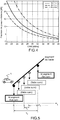
figure 4 : un exemple de courbes donnant la précision d'une mesure de pseudo-distance en fonction du rapport signal à bruit, selon l'invention ; -
figure 5 : un schéma d'un exemple de transmission des informations de position, selon un deuxième mode de réalisation de l'invention ; -
figure 6 : un schéma d'un exemple de transmission des informations de position, selon un troisième mode de réalisation de l'invention ;
-
figures 1a and1b : two schematic examples of positioning systems of a mobile device, satellite, according to the invention; -
figure 2 : An example of a method for determining the position of a GNSS receiver in a mobile device, according to the invention; -
figure 3 : a diagram of an exemplary transmission of position information, according to a first embodiment of the invention; -
figure 4 an example of curves giving the accuracy of a pseudo-distance measurement as a function of the signal-to-noise ratio, according to the invention; -
figure 5 : a diagram of an exemplary transmission of position information, according to a second embodiment of the invention; -
figure 6 : a diagram of an example of transmission of the position information, according to a third embodiment of the invention;
Les
Lorsque la transmission des informations est réalisée en temps réel comme représenté sur la
Lorsque la transmission est reportée dans le temps, comme représenté sur la
Un exemple de méthode de détermination de la position du récepteur GNSS 4 est représenté schématiquement sur la
La position du satellite étant obtenue, il reste au récepteur 4, ou au serveur de positions 3, à détecter l'heure d'émission du message afin de déduire le temps de propagation du signal émis par le satellite et la pseudo-distance le séparant du satellite, puis le rayon d'une des 4 sphères nécessaires, et la position du véhicule 1.The position of the satellite being obtained, it remains to the
Pour réduire le volume d'informations transmises au serveur de position 3, l'invention consiste pour chaque véhicule mobile 1, dans une première étape, à déterminer une première information de position absolue du véhicule à un instant t0 initial puis, dans une deuxième étape, à partir de l'instant initial t0, à déterminer périodiquement, des informations de variations de positions successives dudit véhicule mobile au cours du temps entre des instants de mesures consécutifs, par exemple ti et ti+Tv, i étant un nombre entier supérieur à 0. La détermination des variations de position successives est réalisée à une période Tv prédéterminée choisie en fonction de l'application concernée. De façon à s'assurer que les informations de positions obtenues à partir des valeurs de variations sont correctes et ne dérivent pas dans le temps, le procédé consiste préférentiellement, à déterminer périodiquement, à une période Ta égale à un multiple, supérieur à un, de la période Tv, des informations de position absolue, et entre chaque détermination d'information de position absolue, à déterminer à la période Tv des informations de variations de positions successives dudit véhicule mobile. Les informations de positions absolues ou de variations de positions peuvent être calculées à bord du véhicule mobile par le récepteur 4 puis soit transmises au serveur de positions 3 au fur et à mesure de leur acquisition, soit stockées dans une mémoire 8 du récepteur 4 et transmises globalement par l'intermédiaire d'un point d'accès de radiocommunication local. Alternativement, les informations de positions absolues ou de variations de positions peuvent être calculées par le serveur de positions 3 à partir des mesures de pseudo-distances, ou respectivement des variations entre des mesures de pseudo-distances consécutives, réalisées et transmises directement par le récepteur 4 sans traitement préalable. Les mesures de pseudo-distances réalisées par le récepteur 4 correspondent aux pseudo-distances qui séparent le véhicule des satellites du système de localisation.To reduce the volume of information transmitted to the
Dans un premier mode de réalisation de l'invention représenté sur la
La précision des mesures réalisées par le récepteur 4 et la précision des informations de position qui sont déterminées à partir de ces mesures, dépendent de la qualité des signaux GNSS reçus par le récepteur 4 et en particulier du rapport signal à bruit reçu ou des résidus permettant de calculer la position. Par conséquent, les mesures réalisées, les valeurs absolues correspondant à la latitude lat, la longitude long et l'altitude alt du véhicule ainsi que les valeurs de variations correspondant aux variations de latitude δlat, de longitude δlong et d'altitude δalt du véhicule entre des instants de mesure consécutifs comportent un nombre de chiffres significatifs dont l'importance peut varier. Avantageusement, l'invention consiste en outre, à déterminer quels sont les chiffres les plus significatifs et, au niveau du codage binaire de l'information à transmettre, à attribuer une importance moindre aux chiffres moins significatifs.The accuracy of the measurements made by the
L'importance des chiffres significatifs peut être estimée à partir d'une mesure du rapport signal à bruit réalisée sur chaque signal GNSS reçu et pris en compte dans le calcul de la position. La relation entre le rapport signal à bruit et une estimation de la précision de mesure de pseudo-distance est connue de l'homme de l'art et est obtenue par les relations décrites ci-après.The importance of the significant digits can be estimated from a measurement of the signal-to-noise ratio carried out on each received GNSS signal and taken into account in the calculation of the position. The relationship between the signal-to-noise ratio and an estimate of the pseudo-range measurement accuracy is known to those skilled in the art and is obtained by the relationships described hereinafter.
La précision globale de la mesure de pseudo-distance dépend d'un ensemble de contributions :
- ▪ Précision σo liée à la précision d'orbite des satellites, typiquement de l'ordre de 1 m,
- ▪ Précision σc liée à la précision d'horloge du satellite, typiquement bornée par la valeur de 2m,
- ▪ Précision σio liée à la traversée ionosphérique, typiquement 1m,
- ▪ Précision liée à la présence de Multi-trajets, σMP, de l'ordre de 1m.
- ▪ Précision liée au bruit thermique, La formule suivante permet en effet de relier classiquement l'écart type sur la mesure de pseudo-distance et le rapport signal à bruit :

- ▪ BL représente la bande de fréquences de la boucle de poursuite du signal GNSS,
- ▪ d représente l'espacement du corrélateur dit 'Avance-Retard' entre le signal reçu et la réplique du code d'étalement utilisé par le satellite concerné par la mesure de pseudo-distance, réplique qui est générée localement par le récepteur,
- ▪ C/N0 représente le rapport signal à bruit
- ▪ Tcoherent réprésente le temps d'intégration cohérent du signal
- ▪ Tc représente la durée de bribe du signal GNSS
- ▪ Precision σ o related to the orbit accuracy of the satellites, typically of the order of 1 m,
- ▪ Precision σ c related to the satellite clock accuracy, typically limited by the value of 2m,
- ▪ Accuracy σ io related to the ionospheric crossing, typically 1m,
- ▪ Precision linked to the presence of Multipaths, σ MP , of the order of 1m.
- ▪ Precision related to thermal noise, the following formula makes it possible to classically connect the standard deviation to the pseudo-distance measurement and the signal-to-noise ratio:
- ▪ B L represents the frequency band of the GNSS signal tracking loop,
- D represents the spacing of the correlator called 'Delay-Advance' between the received signal and the replica of the spreading code used by the satellite concerned by the pseudo-distance measurement, which replica is generated locally by the receiver,
- ▪ C / N0 represents the signal-to-noise ratio
- T coherent represents the coherent integration time of the signal
- ▪ Tc represents the chip duration of the GNSS signal
La précision globale sur la mesure de pseudo-distance vers un satellite k, classiquement dénommée UERE (User Equivalent Range Error) est alors donnée par la relation : ![]()
![]()
La précision de la position du dispositif mobile peut se déduire alors aisément de la précision des mesures de pseudo-distance vers le satellite k σk par application d'un facteur géométrique déterminé par le récepteur et connu par l'homme de métier sous le nom de dilution de géométrie, DOP. ![]()
- σ est la moyenne quadratique des σk , et
- GDOP est donnée par :


- σ is the root mean square of σ k , and
- GDOP is given by:
La sélection du nombre de chiffres significatifs sur la position est alors déduite directement de la précision de position ainsi estimée.The selection of the number of significant digits on the position is then deduced directly from the positional accuracy thus estimated.
Selon une première réalisation de l'invention, les chiffres estimés non significatifs sont supprimés et seuls les chiffres significatifs sont codés et transmis. Selon une variante de réalisation de l'invention, tous les chiffres sont codés et transmis mais les chiffres moins significatifs sont codés sur moins de bits que les chiffres les plus significatifs. La suppression des chiffres dont la fiabilité est douteuse ou leur codage sur un nombre de bits plus faible permet de réduire fortement la quantité d'information à stocker et à transmettre.According to a first embodiment of the invention, the estimated non-significant figures are deleted and only the significant digits are coded and transmitted. According to an alternative embodiment of the invention, all the digits are coded and transmitted but the less significant digits are coded on fewer bits than the most significant digits. The removal of figures whose reliability is questionable or their coding on a lower number of bits can greatly reduce the amount of information to be stored and transmitted.
Typiquement, la précision en fonction du rapport signal à bruit est donnée par des courbes représentées par exemple sur la
Ceci signifie que les chiffres significatifs qui vont au delà d'une précision de 10m n'ont aucune plus value sur le contenu informationnel. Ceci permet de réaliser un encodage de la latitude et la longitude en degré avec seulement 5 chiffres significatifs.This means that significant figures that go beyond a 10m accuracy have no added value on the informational content. This allows encoding of latitude and longitude in degrees with only 5 significant digits.
Dans un deuxième mode de réalisation de l'invention représenté sur la
Dans un troisième mode de réalisation de l'invention représenté sur la
Le codage de Huffman est réalisé à partir de la connaissance de l'identifiant du segment de route sur lequel se trouve le véhicule et est différent pour chaque segment de route. La connaissance du segment de route permet de savoir sur quel type de route se trouve le véhicule, s'il s'agit d'une route départementale, ou d'une route nationale, ou d'une autoroute, si le segment de route est en zone urbaine ou non, et les conditions de limitations de vitesse associées. Ces informations permettent de déterminer la vitesse de circulation la plus probable du véhicule et d'affecter, à cette vitesse de probabilité la plus forte, une valeur de codage sur un nombre de bits minimal, les autres vitesses étant codées avec un nombre de bits d'autant plus grand que leur probabilité diminue.The Huffman coding is made from the knowledge of the identifier of the road segment on which the vehicle is located and is different for each road segment. The knowledge of the road segment makes it possible to know on which type of road the vehicle is, if it is a departmental road, or a national road, or a highway, if the road segment is in urban areas or not, and the associated speed limit conditions. This information makes it possible to determine the most probable circulation speed of the vehicle and to assign, at this highest probability speed, a coding value over a minimum number of bits, the other speeds being coded with a number of bits of data. as much as their probability decreases.
Par exemple, sur une route nationale, en dehors d'une ville, il y a une forte probabilité pour que le véhicule roule, par exemple, à quatre-vingt kilomètres par heure. Si le récepteur 4 transmet une variation d'abscisse curviligne toutes les secondes, il y a une forte probabilité pour que le véhicule ait parcouru vingt mètres entre deux instants de mesures successifs. Cette valeur la plus probable sera donc codée en binaire, par exemple par la valeur 1. A chaque fois que le récepteur 4 transmettra la valeur 1, correspondant à un seul bit, cela signifiera que le véhicule aura parcouru environ vingt mètres. En revanche, si le véhicule parcourt cinquante mètres, le récepteur enverra un nombre de bits supérieur à un, par exemple trois bits. Chacune des distances parcourues sera ainsi codée par des valeurs différentes selon le principe connu de Huffman, la valeur la plus probable étant codée sur le nombre de bits le plus faible. A chaque segment de route correspond un codage de Huffman spécifique par exemple stocké dans une base de données cartographique vectorielle du récepteur 4 et/ou stocké dans une mémoire du serveur de position 3.For example, on a national road, outside a city, there is a high probability that the vehicle will roll, for example, at eighty kilometers per hour. If the
Claims (11)
- Method for the transmission of position information by a mobile device consisting in acquiring, on board the mobile device, position information of the mobile device (1) from GNSS navigation signals transmitted by a satellite constellation (5a, 5b, 5c) and in transmitting the position information to a position server (3), characterized in that it consists:- starting from an initial time t0 and at successive times ti greater than t0 and spaced by a period Tv, in periodically measuring pseudo-distances (d1, d2, d3) of separation of the mobile device (1) with respect to the satellites (5a, 5b, 5c) of the constellation,- on the basis of the pseudo-distance measurement carried out at the initial time t0, in determining a first item of absolute position information of the mobile device at the initial time t0,- starting with the absolute position information at the initial time and for each measurement carried out at the successive times ti in determining successive items of information on the position variation of the said mobile device (1) between two consecutive measurement times ti and ti +Tv,- in encoding and transmitting the absolute position information and the successive items of position variation information to the position server (3).
- Method according to Claim 1, characterized in that it furthermore consists, on the basis of the pseudo-distance measurements carried out at the successive times ti and on the basis of the absolute position information at the initial time t0, in periodically determining, with a period Ta, items of absolute position information of the mobile device (1), the period Ta being equal to a multiple, greater than one, of the period Tv.
- Method according to one of Claims 1 or 2, characterized in that the absolute position information and the position variation information transmitted to the position server (3) by the mobile device (1) are the pseudo-distance measurements acquired by the mobile device (1) and variations of pseudo-distance calculated on board the mobile device (1) respectively, the successive positions of the mobile device (1) being calculated by the position server (3).
- Method according to one of Claims 1 or 2, characterized in that the absolute position information and the position variation information are respectively triplets of values corresponding to the latitude (lat), longitude (long) and altitude (alt) of the mobile device (1) and variations of latitude (δlat), of longitude (δlong) and of altitude (δalt) of the mobile device (1).
- Method according to Claim 4, characterized in that the absolute position and the position variation items of information are real numbers comprising a number of successive significant figures of variable importance, and in that it furthermore consists, for each item of information, in selecting the significant figures according to an estimation of their degree of importance and in transmitting a reduced number of significant figures to the position server (3), the figures estimated to be of least importance being eliminated.
- Method according to Claim 4, characterized in that the absolute position information and the position variation information are real numbers comprising a number of successive significant figures of variable importance, and in that it furthermore consists, for each item of information, in selecting the significant figures according to an estimation of their degree of importance and in encoding and then transmitting all of the significant figures, the figures estimated to be of least importance being encoded using a number of bits lower than the number of bits used for the figures having a higher degree of importance.
- Method according to one of Claims 1 or 2, characterized in that it consists in furthermore transmitting an identifier of a road segment on which the mobile device (1) is located and in that the absolute position and position variation items of information are curvilinear abscissas and curvilinear abscissa variations respectively of the mobile device (1) on the road segment.
- Method according to Claim 7, characterized in that the road segment identifier is obtained from a vector cartographic database.
- Method according to Claim 7, characterized in that the curvilinear abscissas and the curvilinear abscissa variations are calculated and encoded on board the mobile device (1) with a binary code provided by a Huffman table stored in a vector cartographic database or provided by the position server (3).
- Method according to any one of the preceding claims, characterized in that the transmission of the position and position variation items of information is carried out progressively, as they are acquired, by a cellular network mobile communication system.
- Method according to any one of Claims 1 to 9, characterized in that the position and position variation items of information are stored in an on-board memory (8) of the mobile device (1) and transmitted globally when the mobile device (1) passes close to a terrestrial relay provided with a radio-communication system.
Applications Claiming Priority (1)
| Application Number | Priority Date | Filing Date | Title |
|---|---|---|---|
| FR0902368A FR2945700B1 (en) | 2009-05-15 | 2009-05-15 | METHOD FOR TRANSMITTING POSITION INFORMATION BY A MOBILE DEVICE |
Publications (3)
| Publication Number | Publication Date |
|---|---|
| EP2259643A2 EP2259643A2 (en) | 2010-12-08 |
| EP2259643A3 EP2259643A3 (en) | 2015-05-20 |
| EP2259643B1 true EP2259643B1 (en) | 2018-10-10 |
Family
ID=41259346
Family Applications (1)
| Application Number | Title | Priority Date | Filing Date |
|---|---|---|---|
| EP10157816.9A Active EP2259643B1 (en) | 2009-05-15 | 2010-03-25 | Method for transmitting position information by a mobile device |
Country Status (4)
| Country | Link |
|---|---|
| EP (1) | EP2259643B1 (en) |
| ES (1) | ES2704023T3 (en) |
| FR (1) | FR2945700B1 (en) |
| SG (1) | SG166734A1 (en) |
Cited By (1)
| Publication number | Priority date | Publication date | Assignee | Title |
|---|---|---|---|---|
| EP3944203A1 (en) | 2020-07-23 | 2022-01-26 | Toll Collect GmbH | Method and system for recording position data in a toll system |
Family Cites Families (4)
| Publication number | Priority date | Publication date | Assignee | Title |
|---|---|---|---|---|
| US7660588B2 (en) * | 2002-10-17 | 2010-02-09 | Qualcomm Incorporated | Method and apparatus for improving radio location accuracy with measurements |
| US20080171557A1 (en) * | 2004-04-14 | 2008-07-17 | Xiang Bernard | Method, System and Module for Locating a Telecommunications Terminal |
| US7395075B2 (en) * | 2004-09-09 | 2008-07-01 | Nextel Communications Inc. | System and method for collecting continuous location updates while minimizing overall network utilization |
| KR100690877B1 (en) * | 2005-08-11 | 2007-03-09 | 엘지전자 주식회사 | Periodic positioning method in mobile communication system |
-
2009
- 2009-05-15 FR FR0902368A patent/FR2945700B1/en not_active Expired - Fee Related
-
2010
- 2010-03-25 ES ES10157816T patent/ES2704023T3/en active Active
- 2010-03-25 EP EP10157816.9A patent/EP2259643B1/en active Active
- 2010-04-23 SG SG201002938-7A patent/SG166734A1/en unknown
Non-Patent Citations (1)
| Title |
|---|
| None * |
Cited By (1)
| Publication number | Priority date | Publication date | Assignee | Title |
|---|---|---|---|---|
| EP3944203A1 (en) | 2020-07-23 | 2022-01-26 | Toll Collect GmbH | Method and system for recording position data in a toll system |
Also Published As
| Publication number | Publication date |
|---|---|
| FR2945700A1 (en) | 2010-11-19 |
| FR2945700B1 (en) | 2011-05-20 |
| EP2259643A2 (en) | 2010-12-08 |
| ES2704023T3 (en) | 2019-03-13 |
| SG166734A1 (en) | 2010-12-29 |
| EP2259643A3 (en) | 2015-05-20 |
Similar Documents
| Publication | Publication Date | Title |
|---|---|---|
| EP1804071B1 (en) | Method for optimising positioning data processing where there are several satellite positioning constellations | |
| EP1712930B1 (en) | System and procedure for determining the instantaneous speed of an object | |
| KR101102283B1 (en) | System and/or method for reducing ambiguities in received sps signals | |
| EP2566069B1 (en) | Detection method of messages of type "Automatic Identification System" for monitoring of vessels and buoys by satellite. | |
| JP5377956B2 (en) | Method and apparatus for measurement processing of satellite positioning system (SPS) signals | |
| EP1836507B1 (en) | Positioning device and method | |
| EP1904869B1 (en) | Method and device for determining the ground position of a mobile object, in particular an aircraft on an airport | |
| US7705775B2 (en) | Method of improving a vehicle emergency call network | |
| EP1876466B1 (en) | Device for the generation of integrity messages signalling nominal, degraded or inactive surveillance stations for satellite navigation systems | |
| MXPA00010883A (en) | Method and apparatus for signal processing in a satellite positioning system. | |
| FR2795525A1 (en) | METHOD AND APPARATUS FOR DETERMINING A GEOGRAPHICAL POSITION OF A MOBILE UNIT | |
| FR3057348A1 (en) | METHOD OF LOCALLY LOCATING A VEHICLE EVOLVING ON A CONSTANT TRACK AND ASSOCIATED SYSTEM | |
| EP1804070B1 (en) | Method for fast acquisition of satellite signals | |
| CN101517429A (en) | System and/or method for acquisition of GNSS signals | |
| EP2333582B1 (en) | Method for detecting fraud in the transmission of position information by a mobile device | |
| EP2331983B1 (en) | Method for optimising an acquisition of a spread-spectrum signal from a satellite by a mobile receiver | |
| EP1544636A1 (en) | Determination device by filtering of integrity data in a differential positioning system, for a mobile terminal | |
| EP2259643B1 (en) | Method for transmitting position information by a mobile device | |
| EP3808142B1 (en) | Method and system for geolocating a terminal of a wireless communication system | |
| Kubrak | Hybridisation of a GPS Receiver with Low-Cost Sensors for Personal Positioning in Urban Environment. | |
| EP2626725B1 (en) | Method for determining a confidence indicator relating to the path taken by a mobile | |
| FR2836997A1 (en) | METHOD AND DEVICE FOR DETERMINING THE RELATIVE POSITION OF TWO POINTS, BASED ON SATELLITE POSITIONING SIGNALS | |
| Vu | Spatial altimetry, GNSS reflectometry and marine surcotes | |
| FR3136065A1 (en) | Method and system for locating a mobile node by radio measurements using a visibility map | |
| WO2022269199A1 (en) | Method for estimating and predicting an index of total electron content vertically to the seas and oceans |
Legal Events
| Date | Code | Title | Description |
|---|---|---|---|
| PUAI | Public reference made under article 153(3) epc to a published international application that has entered the european phase |
Free format text: ORIGINAL CODE: 0009012 |
|
| AK | Designated contracting states |
Kind code of ref document: A2 Designated state(s): AT BE BG CH CY CZ DE DK EE ES FI FR GB GR HR HU IE IS IT LI LT LU LV MC MK MT NL NO PL PT RO SE SI SK SM TR |
|
| AX | Request for extension of the european patent |
Extension state: AL BA ME RS |
|
| PUAL | Search report despatched |
Free format text: ORIGINAL CODE: 0009013 |
|
| AK | Designated contracting states |
Kind code of ref document: A3 Designated state(s): AT BE BG CH CY CZ DE DK EE ES FI FR GB GR HR HU IE IS IT LI LT LU LV MC MK MT NL NO PL PT RO SE SI SK SM TR |
|
| AX | Request for extension of the european patent |
Extension state: AL BA ME RS |
|
| RIC1 | Information provided on ipc code assigned before grant |
Ipc: H04W 64/00 20090101AFI20150414BHEP Ipc: G01S 5/00 20060101ALI20150414BHEP |
|
| 17P | Request for examination filed |
Effective date: 20150925 |
|
| RBV | Designated contracting states (corrected) |
Designated state(s): AT BE BG CH CY CZ DE DK EE ES FI FR GB GR HR HU IE IS IT LI LT LU LV MC MK MT NL NO PL PT RO SE SI SK SM TR |
|
| GRAP | Despatch of communication of intention to grant a patent |
Free format text: ORIGINAL CODE: EPIDOSNIGR1 |
|
| STAA | Information on the status of an ep patent application or granted ep patent |
Free format text: STATUS: GRANT OF PATENT IS INTENDED |
|
| INTG | Intention to grant announced |
Effective date: 20180524 |
|
| GRAS | Grant fee paid |
Free format text: ORIGINAL CODE: EPIDOSNIGR3 |
|
| RAP1 | Party data changed (applicant data changed or rights of an application transferred) |
Owner name: THALES |
|
| GRAA | (expected) grant |
Free format text: ORIGINAL CODE: 0009210 |
|
| STAA | Information on the status of an ep patent application or granted ep patent |
Free format text: STATUS: THE PATENT HAS BEEN GRANTED |
|
| AK | Designated contracting states |
Kind code of ref document: B1 Designated state(s): AT BE BG CH CY CZ DE DK EE ES FI FR GB GR HR HU IE IS IT LI LT LU LV MC MK MT NL NO PL PT RO SE SI SK SM TR |
|
| REG | Reference to a national code |
Ref country code: GB Ref legal event code: FG4D Free format text: NOT ENGLISH |
|
| REG | Reference to a national code |
Ref country code: CH Ref legal event code: EP Ref country code: AT Ref legal event code: REF Ref document number: 1052766 Country of ref document: AT Kind code of ref document: T Effective date: 20181015 |
|
| REG | Reference to a national code |
Ref country code: IE Ref legal event code: FG4D Free format text: LANGUAGE OF EP DOCUMENT: FRENCH |
|
| REG | Reference to a national code |
Ref country code: DE Ref legal event code: R096 Ref document number: 602010054167 Country of ref document: DE |
|
| REG | Reference to a national code |
Ref country code: NL Ref legal event code: MP Effective date: 20181010 |
|
| REG | Reference to a national code |
Ref country code: LT Ref legal event code: MG4D |
|
| REG | Reference to a national code |
Ref country code: ES Ref legal event code: FG2A Ref document number: 2704023 Country of ref document: ES Kind code of ref document: T3 Effective date: 20190313 |
|
| REG | Reference to a national code |
Ref country code: AT Ref legal event code: MK05 Ref document number: 1052766 Country of ref document: AT Kind code of ref document: T Effective date: 20181010 |
|
| PG25 | Lapsed in a contracting state [announced via postgrant information from national office to epo] |
Ref country code: NL Free format text: LAPSE BECAUSE OF FAILURE TO SUBMIT A TRANSLATION OF THE DESCRIPTION OR TO PAY THE FEE WITHIN THE PRESCRIBED TIME-LIMIT Effective date: 20181010 |
|
| PG25 | Lapsed in a contracting state [announced via postgrant information from national office to epo] |
Ref country code: AT Free format text: LAPSE BECAUSE OF FAILURE TO SUBMIT A TRANSLATION OF THE DESCRIPTION OR TO PAY THE FEE WITHIN THE PRESCRIBED TIME-LIMIT Effective date: 20181010 Ref country code: LV Free format text: LAPSE BECAUSE OF FAILURE TO SUBMIT A TRANSLATION OF THE DESCRIPTION OR TO PAY THE FEE WITHIN THE PRESCRIBED TIME-LIMIT Effective date: 20181010 Ref country code: FI Free format text: LAPSE BECAUSE OF FAILURE TO SUBMIT A TRANSLATION OF THE DESCRIPTION OR TO PAY THE FEE WITHIN THE PRESCRIBED TIME-LIMIT Effective date: 20181010 Ref country code: IS Free format text: LAPSE BECAUSE OF FAILURE TO SUBMIT A TRANSLATION OF THE DESCRIPTION OR TO PAY THE FEE WITHIN THE PRESCRIBED TIME-LIMIT Effective date: 20190210 Ref country code: BG Free format text: LAPSE BECAUSE OF FAILURE TO SUBMIT A TRANSLATION OF THE DESCRIPTION OR TO PAY THE FEE WITHIN THE PRESCRIBED TIME-LIMIT Effective date: 20190110 Ref country code: NO Free format text: LAPSE BECAUSE OF FAILURE TO SUBMIT A TRANSLATION OF THE DESCRIPTION OR TO PAY THE FEE WITHIN THE PRESCRIBED TIME-LIMIT Effective date: 20190110 Ref country code: PL Free format text: LAPSE BECAUSE OF FAILURE TO SUBMIT A TRANSLATION OF THE DESCRIPTION OR TO PAY THE FEE WITHIN THE PRESCRIBED TIME-LIMIT Effective date: 20181010 Ref country code: HR Free format text: LAPSE BECAUSE OF FAILURE TO SUBMIT A TRANSLATION OF THE DESCRIPTION OR TO PAY THE FEE WITHIN THE PRESCRIBED TIME-LIMIT Effective date: 20181010 Ref country code: LT Free format text: LAPSE BECAUSE OF FAILURE TO SUBMIT A TRANSLATION OF THE DESCRIPTION OR TO PAY THE FEE WITHIN THE PRESCRIBED TIME-LIMIT Effective date: 20181010 |
|
| PG25 | Lapsed in a contracting state [announced via postgrant information from national office to epo] |
Ref country code: SE Free format text: LAPSE BECAUSE OF FAILURE TO SUBMIT A TRANSLATION OF THE DESCRIPTION OR TO PAY THE FEE WITHIN THE PRESCRIBED TIME-LIMIT Effective date: 20181010 Ref country code: GR Free format text: LAPSE BECAUSE OF FAILURE TO SUBMIT A TRANSLATION OF THE DESCRIPTION OR TO PAY THE FEE WITHIN THE PRESCRIBED TIME-LIMIT Effective date: 20190111 Ref country code: PT Free format text: LAPSE BECAUSE OF FAILURE TO SUBMIT A TRANSLATION OF THE DESCRIPTION OR TO PAY THE FEE WITHIN THE PRESCRIBED TIME-LIMIT Effective date: 20190210 |
|
| REG | Reference to a national code |
Ref country code: DE Ref legal event code: R097 Ref document number: 602010054167 Country of ref document: DE |
|
| PG25 | Lapsed in a contracting state [announced via postgrant information from national office to epo] |
Ref country code: CZ Free format text: LAPSE BECAUSE OF FAILURE TO SUBMIT A TRANSLATION OF THE DESCRIPTION OR TO PAY THE FEE WITHIN THE PRESCRIBED TIME-LIMIT Effective date: 20181010 Ref country code: DK Free format text: LAPSE BECAUSE OF FAILURE TO SUBMIT A TRANSLATION OF THE DESCRIPTION OR TO PAY THE FEE WITHIN THE PRESCRIBED TIME-LIMIT Effective date: 20181010 |
|
| PLBE | No opposition filed within time limit |
Free format text: ORIGINAL CODE: 0009261 |
|
| STAA | Information on the status of an ep patent application or granted ep patent |
Free format text: STATUS: NO OPPOSITION FILED WITHIN TIME LIMIT |
|
| PG25 | Lapsed in a contracting state [announced via postgrant information from national office to epo] |
Ref country code: SK Free format text: LAPSE BECAUSE OF FAILURE TO SUBMIT A TRANSLATION OF THE DESCRIPTION OR TO PAY THE FEE WITHIN THE PRESCRIBED TIME-LIMIT Effective date: 20181010 Ref country code: RO Free format text: LAPSE BECAUSE OF FAILURE TO SUBMIT A TRANSLATION OF THE DESCRIPTION OR TO PAY THE FEE WITHIN THE PRESCRIBED TIME-LIMIT Effective date: 20181010 Ref country code: EE Free format text: LAPSE BECAUSE OF FAILURE TO SUBMIT A TRANSLATION OF THE DESCRIPTION OR TO PAY THE FEE WITHIN THE PRESCRIBED TIME-LIMIT Effective date: 20181010 Ref country code: SM Free format text: LAPSE BECAUSE OF FAILURE TO SUBMIT A TRANSLATION OF THE DESCRIPTION OR TO PAY THE FEE WITHIN THE PRESCRIBED TIME-LIMIT Effective date: 20181010 |
|
| 26N | No opposition filed |
Effective date: 20190711 |
|
| PG25 | Lapsed in a contracting state [announced via postgrant information from national office to epo] |
Ref country code: SI Free format text: LAPSE BECAUSE OF FAILURE TO SUBMIT A TRANSLATION OF THE DESCRIPTION OR TO PAY THE FEE WITHIN THE PRESCRIBED TIME-LIMIT Effective date: 20181010 Ref country code: MC Free format text: LAPSE BECAUSE OF FAILURE TO SUBMIT A TRANSLATION OF THE DESCRIPTION OR TO PAY THE FEE WITHIN THE PRESCRIBED TIME-LIMIT Effective date: 20181010 |
|
| REG | Reference to a national code |
Ref country code: CH Ref legal event code: PL |
|
| GBPC | Gb: european patent ceased through non-payment of renewal fee |
Effective date: 20190325 |
|
| PG25 | Lapsed in a contracting state [announced via postgrant information from national office to epo] |
Ref country code: LU Free format text: LAPSE BECAUSE OF NON-PAYMENT OF DUE FEES Effective date: 20190325 |
|
| PG25 | Lapsed in a contracting state [announced via postgrant information from national office to epo] |
Ref country code: CH Free format text: LAPSE BECAUSE OF NON-PAYMENT OF DUE FEES Effective date: 20190331 Ref country code: LI Free format text: LAPSE BECAUSE OF NON-PAYMENT OF DUE FEES Effective date: 20190331 Ref country code: IE Free format text: LAPSE BECAUSE OF NON-PAYMENT OF DUE FEES Effective date: 20190325 Ref country code: GB Free format text: LAPSE BECAUSE OF NON-PAYMENT OF DUE FEES Effective date: 20190325 |
|
| PG25 | Lapsed in a contracting state [announced via postgrant information from national office to epo] |
Ref country code: TR Free format text: LAPSE BECAUSE OF FAILURE TO SUBMIT A TRANSLATION OF THE DESCRIPTION OR TO PAY THE FEE WITHIN THE PRESCRIBED TIME-LIMIT Effective date: 20181010 |
|
| PG25 | Lapsed in a contracting state [announced via postgrant information from national office to epo] |
Ref country code: MT Free format text: LAPSE BECAUSE OF FAILURE TO SUBMIT A TRANSLATION OF THE DESCRIPTION OR TO PAY THE FEE WITHIN THE PRESCRIBED TIME-LIMIT Effective date: 20181010 |
|
| PG25 | Lapsed in a contracting state [announced via postgrant information from national office to epo] |
Ref country code: CY Free format text: LAPSE BECAUSE OF FAILURE TO SUBMIT A TRANSLATION OF THE DESCRIPTION OR TO PAY THE FEE WITHIN THE PRESCRIBED TIME-LIMIT Effective date: 20181010 |
|
| PG25 | Lapsed in a contracting state [announced via postgrant information from national office to epo] |
Ref country code: HU Free format text: LAPSE BECAUSE OF FAILURE TO SUBMIT A TRANSLATION OF THE DESCRIPTION OR TO PAY THE FEE WITHIN THE PRESCRIBED TIME-LIMIT; INVALID AB INITIO Effective date: 20100325 |
|
| PG25 | Lapsed in a contracting state [announced via postgrant information from national office to epo] |
Ref country code: MK Free format text: LAPSE BECAUSE OF FAILURE TO SUBMIT A TRANSLATION OF THE DESCRIPTION OR TO PAY THE FEE WITHIN THE PRESCRIBED TIME-LIMIT Effective date: 20181010 |
|
| PGFP | Annual fee paid to national office [announced via postgrant information from national office to epo] |
Ref country code: FR Payment date: 20230221 Year of fee payment: 14 |
|
| PGFP | Annual fee paid to national office [announced via postgrant information from national office to epo] |
Ref country code: IT Payment date: 20230228 Year of fee payment: 14 Ref country code: DE Payment date: 20230214 Year of fee payment: 14 Ref country code: BE Payment date: 20230216 Year of fee payment: 14 |
|
| PGFP | Annual fee paid to national office [announced via postgrant information from national office to epo] |
Ref country code: ES Payment date: 20230406 Year of fee payment: 14 |