EP2259643B1 - Verfahren zur Übertragung von Positionsinformationen über eine mobile Vorrichtung - Google Patents
Verfahren zur Übertragung von Positionsinformationen über eine mobile Vorrichtung Download PDFInfo
- Publication number
- EP2259643B1 EP2259643B1 EP10157816.9A EP10157816A EP2259643B1 EP 2259643 B1 EP2259643 B1 EP 2259643B1 EP 10157816 A EP10157816 A EP 10157816A EP 2259643 B1 EP2259643 B1 EP 2259643B1
- Authority
- EP
- European Patent Office
- Prior art keywords
- mobile device
- information
- position information
- pseudo
- successive
- Prior art date
- Legal status (The legal status is an assumption and is not a legal conclusion. Google has not performed a legal analysis and makes no representation as to the accuracy of the status listed.)
- Active
Links
- 238000000034 method Methods 0.000 title claims description 23
- 238000005259 measurement Methods 0.000 claims description 36
- 230000005540 biological transmission Effects 0.000 claims description 21
- 238000004891 communication Methods 0.000 claims description 4
- 238000010295 mobile communication Methods 0.000 claims description 4
- 230000001413 cellular effect Effects 0.000 claims description 2
- 238000000926 separation method Methods 0.000 claims description 2
- 230000001427 coherent effect Effects 0.000 description 4
- 230000006870 function Effects 0.000 description 4
- 238000010586 diagram Methods 0.000 description 3
- 230000007423 decrease Effects 0.000 description 1
- 238000010790 dilution Methods 0.000 description 1
- 239000012895 dilution Substances 0.000 description 1
- 230000010354 integration Effects 0.000 description 1
- 230000004807 localization Effects 0.000 description 1
- 239000000243 solution Substances 0.000 description 1
Images


Classifications
-
- G—PHYSICS
- G01—MEASURING; TESTING
- G01S—RADIO DIRECTION-FINDING; RADIO NAVIGATION; DETERMINING DISTANCE OR VELOCITY BY USE OF RADIO WAVES; LOCATING OR PRESENCE-DETECTING BY USE OF THE REFLECTION OR RERADIATION OF RADIO WAVES; ANALOGOUS ARRANGEMENTS USING OTHER WAVES
- G01S5/00—Position-fixing by co-ordinating two or more direction or position line determinations; Position-fixing by co-ordinating two or more distance determinations
- G01S5/0009—Transmission of position information to remote stations
- G01S5/0018—Transmission from mobile station to base station
- G01S5/0027—Transmission from mobile station to base station of actual mobile position, i.e. position determined on mobile
Definitions
- the present invention relates to a method of transmitting position information by a mobile device. It applies in particular to the field of road, motorway and urban toll collection systems and to any other location-based payment device, as well as to devices for storing and / or transmitting position information periodically.
- the vehicle In all the tracking systems of a mobile device such as a vehicle or a fleet of vehicles, it is known, particularly from the document US 2006/079244 that the vehicle periodically transmits information concerning its position to a central server.
- the period of transmission depends on the type of application that uses this information. For applications that need to transmit this information very often with a low period of the order of a few seconds, or even a second, the vehicle generally transmits its position by a telecommunication means, for example of the cellular network or satellite type .
- the transmission of the position information is generally performed in the form of sending a triplet of data relating to the latitude, longitude and altitude of the vehicle in a predetermined coordinate system.
- the position information can also be transmitted as a set of pseudo-distances between the mobile device and reference points, the reference points being satellites in the case of using a navigation system by GNSS satellite (in English: Global Navigation Satellite System).
- GNSS satellite in English: Global Navigation Satellite System
- 3GPP in English: Third Generation Partnership Project
- each of the position data is coded in 32-bit binary which implies a bit rate equal to three times 32 bits to be transmitted per second and per vehicle when the position information is relative to latitude, longitude and altitude and the transmission period is one second.
- the object of the invention is to solve these problems and to propose a method for transmitting position information carried by a mobile device that does not have the drawbacks of the known solutions and that makes it possible to limit the volume of the position data to be transmitted.
- the method furthermore consists of measurements of pseudo-distances carried out at successive times t i and from absolute position information at the initial time t 0 , periodically determining, at a period Ta, absolute position information of the mobile device, the period Ta being equal to a multiple, greater than one, of the period Tv .
- the absolute position information and the position change information transmitted to the position server by the mobile device are respectively the pseudo-distance measurements acquired by the mobile device and pseudo-range variations acquired by the mobile device. calculated distances on board the mobile device, the successive positions of the mobile device being calculated by the position server.
- the absolute position information and the position variation information are respectively triplets of values corresponding to the latitude (lat), the longitude (long) and the altitude (alt) of the mobile device and variations of latitude ( ⁇ lat), longitude ( ⁇ long) and altitude ( ⁇ alt) of the mobile device.
- the absolute position information and the position variation information are real numbers comprising a number of successive significant digits of variable importance
- the method furthermore consists, for each piece of information, in selecting the significant digits as a function of an estimate of their importance and to transmit to the position server a significant number of significant digits, the estimated numbers of less importance being deleted.
- the absolute position information and the position change information are real numbers having a number of successive significant digits of variable importance
- the method further comprises, for each piece of information, selecting the significant digits as a function of an estimate of their degree of importance and coding and then transmitting all the significant digits, the estimated numbers of less importance being coded on a number of bits less than the number of bits used for the figures having a higher degree of importance.
- the method consists of transmitting an identifier of a road segment on which the mobile device is located and the absolute position information and the position variation information are respectively curvilinear abscissa and curvilinear abscissa variations of the mobile device on the road segment.
- the road segment identifier is obtained from a vector map database.
- the curvilinear abscissa and the curvilinear abscissa variations are computed and coded on board the mobile device with a binary code provided by a Huffman table stored in a vector cartographic database, or provided by the position server.
- the transmission of position information and positional change information can be performed as and when acquired by a mobile network communication system.
- the position information and position change information or can be stored in a memory on board the mobile device and transmitted globally during the passage of the mobile device near a terrestrial relay provided with a radiocommunication system.
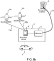
- the figures 1a and 1b represent two examples of location systems of a mobile device 1, for example a vehicle, by satellite, according to the invention.
- the locating system comprises, on board the vehicle 1, a locating and broadcasting device 2 intended to carry out measurements making it possible to determine the position and / or the speed of the vehicle and to transmit this location information to a position server 3 responsible for storing and / or exploiting them.
- the locating and broadcasting device 2 comprises a receiver 4 of GNSS navigation signals (in English: Global Navigation Satellite System) such as a GPS receiver (in English: Global Positioning System) or Galileo, issued by a satellite constellation 5a. , 5b.
- the measurements carried out on board the vehicle can be transmitted directly to the position server 3 which deduces the position information of the vehicle.
- the vehicle position information can be calculated on board the vehicle by the GNSS receiver 4 from the exploitation of signals 13a and 13b emitted by the satellites 5a, 5b.
- the number of satellites must be at least four to determine the four position coordinates of the vehicle in the space x, y, z and in time t.
- the transmission of the position information to the position server 3 can be carried out in real time as and when the acquisition of this information or alternatively, be postponed in time.
- the locating and broadcasting device 2 furthermore comprises a cell-network mobile communication transmitter-receiver 6, for example of the GSM (Global System for Mobile Communications) type, UMTS (Universal Mobile Telecommunications System) , or CDMA (in English: Division Multiple Access Code) connected to the GNSS receiver 4.
- the position information determined by the receiver 4 is then supplied to the mobile communication transceiver 6 which, according to a predetermined period depending on the application, sends said position information to the position server 3 through a communication channel 12 and via a terrestrial relay such as for example a base station 7 covering a coverage area, also called cell, in which is the mobile device 1, or a road gantry.
- a terrestrial relay such as for example a base station 7 covering a coverage area, also called cell, in which is the mobile device 1, or a road gantry.
- the position information acquired successively by the receiver 4 is stored in a memory 8 of this receiver 4 and transmitted simultaneously to the position server 3 via a local radio access point such as, for example, a Gantry-type gantry crane equipped with radiocommunication means.
- a local radio access point such as, for example, a Gantry-type gantry crane equipped with radiocommunication means.
- the delay in the transmission of position information eliminates mobile phone systems which is more economical.
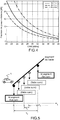
- the method consists for the receiver 4 to determine the pseudo-distances d1, d2, d3 separating it from at least three satellites 5a, 5b, 5c of the constellation and then to deduce the point of intersection 14 of the spheres whose center is materialized by the position of the satellite itself and whose radius is provided by the pseudo-distances d1, d2, d3.
- the position of the GNSS receiver 4 corresponds to this point of intersection 14.
- the measurement of the pseudo-distances d1, d2, d3 is performed in the receiver 4 by timing the arrival time of radio signals constituting a navigation message from the satellites 5a, 5b, 5c.
- the essential information from each satellite via the navigation message and to be processed by the receiver is constituted by the date of transmission of the message and the position of the satellite at the time of transmission of the radio signal.
- the satellite transmits in its navigation message its ephemeris (Keplerian parameters) allowing the receiver 4, or the position server 3, to calculate the position of the satellite in a frame linked to the Earth.
- the ephemeris are constituted in the case of a GPS signal of 16 parameters repeated every 30 seconds in the navigation message.
- the position of the satellite being obtained it remains to the receiver 4, or the position server 3, to detect the time of transmission of the message in order to deduce the propagation time of the signal transmitted by the satellite and the pseudo-distance separating it of the satellite, then the radius of one of the 4 necessary spheres, and the position of the vehicle 1.
- the invention consists for each mobile vehicle 1, in a first step, to determine a first position absolute information of the vehicle at an initial time t 0 and then, in a second step, from the initial moment t 0 , to be determined periodically, information of variations of successive positions of said mobile vehicle over time between instants of consecutive measurements, for example t i and t i + Tv, i being an integer greater than 0.
- the determination of the successive positional variations is carried out at a predetermined period T v chosen according to the application concerned.
- the method preferably consists, periodically, in a period Ta equal to a multiple, greater than one, of the period Tv, absolute position information, and between each determination of absolute position information, to determine at the period Tv information of successive positional changes of said moving vehicle.
- the information of absolute positions or position variations can be calculated on board the mobile vehicle by the receiver 4 and then transmitted to the position server 3 as and when they are acquired, or stored in a memory 8 of the receiver 4 and transmitted globally via a local radio access point.
- the information of absolute positions or positional variations can be calculated by the position server 3 from measurements of pseudo-distances, or respectively variations between consecutive pseudo-distances measurements, made and transmitted directly by the receiver 4 without prior treatment.
- the pseudo-range measurements carried out by the receiver 4 correspond to the pseudo-distances which separate the vehicle from the satellites of the positioning system.
- the absolute position information determined at the period Ta are triplets of values corresponding to the lat latitude, the long longitude and the alt altitude of the vehicle, and the variations of successive positions determined at the period Tv are triplets of values corresponding to the variations of latitude ⁇ lat, longitude ⁇ long and altitude ⁇ alt of the vehicle between consecutive moments of measurement, for example t i and t i + Tv.
- the accuracy of the measurements made by the receiver 4 and the accuracy of the position information which are determined from these measurements depend on the quality of the GNSS signals received by the receiver 4 and in particular the signal-to-noise ratio received or residues to calculate the position. Consequently, the measurements taken, the absolute values corresponding to the latitude lat, the long longitude and the altitude alt of the vehicle as well as the values of variations corresponding to the variations of latitude ⁇ lat, longitude ⁇ long and altitude ⁇ alt of the vehicle between consecutive moments of measurement include a number of significant figures, the importance of which may vary.
- the invention furthermore consists in determining which are the most significant digits and, at the level of the binary coding of the information to be transmitted, assigning less importance to the less significant digits.
- the importance of the significant digits can be estimated from a measurement of the signal-to-noise ratio carried out on each received GNSS signal and taken into account in the calculation of the position.
- the relationship between the signal-to-noise ratio and an estimate of the pseudo-range measurement accuracy is known to those skilled in the art and is obtained by the relationships described hereinafter.
- the estimated non-significant figures are deleted and only the significant digits are coded and transmitted.
- all the digits are coded and transmitted but the less significant digits are coded on fewer bits than the most significant digits. The removal of figures whose reliability is questionable or their coding on a lower number of bits can greatly reduce the amount of information to be stored and transmitted.
- the information of absolute positions determined during the period Ta are two values respectively corresponding to an identifier of the road segment on which the mobile vehicle is located and the curvilinear abscissa corresponding to the position of the vehicle on said road segment .
- the variations of successive positions determined, at the period Tv, between two absolute position measurements are variations of the curvilinear abscissa of the vehicle between consecutive measurement instants, for example t i and t i + Tv.
- the identifier of the road segment on which the vehicle is located is determined by means of a vector map database for example installed in the GNSS receiver 4.
- the vector map database identifies a road segment by a point of origin and a point of arrival, which makes it possible to obtain a geometrical representation of each segment of road.
- This second embodiment of the invention makes it possible to transmit only one position information coded in binary instead of three at each measurement period Tv and to further reduce the volume of information to be transmitted to the position server 3.
- the curvilinear abscissa and the curvilinear abscissa variations are calculated on board the vehicle by the receiver 4 and encoded with a binary code depending on the road segment on which the vehicle is located prior to their transmission to the position server 3.
- This coding makes it possible to further compress the information transmitted to the server of positions.
- the binary code can for example be provided by the position server or by a Huffman table stored in a vector map base installed in the receiver 4. In the case of a coding provided by a Huffman table, to allow the decoding of the coded message transmitted by the receiver 4, the Huffman table is also stored in a memory of the position server 3.
- the transmission of coded information is performed by a radio communication means such as a terrestrial relay.
- the Huffman coding is made from the knowledge of the identifier of the road segment on which the vehicle is located and is different for each road segment.
- the knowledge of the road segment makes it possible to know on which type of road the vehicle is, if it is a departmental road, or a national road, or a highway, if the road segment is in urban areas or not, and the associated speed limit conditions. This information makes it possible to determine the most probable circulation speed of the vehicle and to assign, at this highest probability speed, a coding value over a minimum number of bits, the other speeds being coded with a number of bits of data. as much as their probability decreases.
- the receiver 4 transmits a curvilinear abscissa variation every second, there is a high probability that the vehicle has traveled twenty meters between two instants of successive measurements. This most probable value will therefore be coded in binary, for example by the value 1. Each time the receiver 4 transmits the value 1, corresponding to a single bit, this will mean that the vehicle will have traveled about twenty meters. On the other hand, if the vehicle travels fifty meters, the receiver will send a number of bits greater than one, for example three bits.
- Each of the distances traveled will thus be encoded by different values according to the known Huffman principle, the most probable value being coded on the lowest number of bits.
- Each segment of route corresponds to a specific Huffman coding, for example stored in a vector map database of the receiver 4 and / or stored in a memory of the position server 3.
Landscapes
- Physics & Mathematics (AREA)
- Engineering & Computer Science (AREA)
- General Physics & Mathematics (AREA)
- Radar, Positioning & Navigation (AREA)
- Remote Sensing (AREA)
- Position Fixing By Use Of Radio Waves (AREA)
- Navigation (AREA)
Claims (11)
- Verfahren zum Übertragen von Positionsinformationen über eine mobile Vorrichtung, darin bestehend, an Bord der mobilen Vorrichtung Positionsinformationen der mobilen Vorrichtung (1) anhand von GNSS-Navigationssignalen zu erfassen, welche durch eine Satellitenkonstellation (5a, 5b, 5c) gesendet werden und die Positionsinformationen an einen Positionsserver (3) zu übertragen, dadurch gekennzeichnet, dass es in Folgendem besteht:- im regelmäßigen Messen von Pseudotrennungsdistanzen (d1, d2, d3) zwischen der mobilen Vorrichtung (1) und den Satelliten (5a, 5b, 5c) der Konstellation, ab einem anfänglichen Zeitpunkt to und zu aufeinanderfolgenden Zeitpunkten ti, welche größer als to und durch einen Zeitabstand Tv getrennt sind,- im Bestimmen, anhand der Messung einer Pseudodistanz, welche zum anfänglichen Zeitpunkt to bewerkstelligt wird, einer ersten Absolut-Positionsinformation der mobilen Vorrichtung zum anfänglichen Zeitpunkt to,- im Bestimmen der aufeinanderfolgenden Positions-Variationsinformationen der mobilen Vorrichtung (1) zwischen zwei aufeinanderfolgenden Messzeitpunkten ti und ti +Tv, anhand der Absolut-Positionsinformation zum anfänglichen Zeitpunkt und für jede Messung zu den aufeinander folgenden Zeitpunkten ti,- im Codieren und Übertragen der Absolut-Positionsinformation und der aufeinanderfolgenden Positions-Variationsinformationen an den Positions-Server (3).
- Verfahren nach Anspruch 1, dadurch gekennzeichnet, dass es zudem darin besteht, anhand der Messungen von Pseudodistanzen, welche zu den aufeinander folgenden Zeitpunkten ti bewerkstelligt werden und anhand der Absolut-Positionsinformation zum Zeitpunkt to, regelmäßig im Abstand eines Zeitraums Ta Absolut-Positionsinformation der mobilen Vorrichtung (1) zu bestimmen, wobei der Zeitraum Ta ein Vielfaches des Zeitraums Tv größer als eins ist.
- Verfahren nach einem der Ansprüche 1 oder 2, dadurch gekennzeichnet, dass die Absolut-Positionsinformationen und die Positions-Variationsinformationen, welche an den Positions-Server (3) durch die mobile Vorrichtung (1) übertragen werden, jeweils Messungen von Pseudodistanzen sind, welche von der mobilen Vorrichtung (1) erfasst werden und Variationen von Pseudodistanzen, welche an Bord der mobilen Vorrichtung (1) berechnet werden, wobei die aufeinander folgenden Positionen der mobilen Vorrichtung (1) durch den Positions-Server (3) berechnet werden.
- Verfahren nach einem der Ansprüche 1 oder 2, dadurch gekennzeichnet, dass die Absolut-Positionsinformationen und die Positions-Variationsinformationen jeweils Tripletten von Werten sind, welche dem Breitengrad (lat), dem Längengrad (long) und der Höhe (alt) der mobilen Vorrichtung (1) und Variationen von Breitengrad (δlat), Längengrad (δlong) und Höhe (δalt) der mobilen Vorrichtung (1) entsprechen.
- Verfahren nach Anspruch 4, dadurch gekennzeichnet, dass die Absolut-Positionsinformationen und die Positions-Variationsinformationen reelle Zahlen sind, welche eine Anzahl signifikanter aufeinanderfolgender Stellen variabler Bedeutung beinhalten, und dadurch, dass es zudem darin besteht, für jede Information die signifikanten Stellen gemäß einer Schätzung ihres Bedeutungsgrades auszuwählen und an den Positions-Server (3) eine reduzierte Anzahl signifikanter Stellen zu übertragen, wobei die als von geringerer Bedeutung geschätzten Stellen gelöscht werden.
- Verfahren nach Anspruch 4, dadurch gekennzeichnet, dass die Absolut-Positionsinformationen und die Positions-Variationsinformationen reelle Zahlen sind, welche eine Anzahl signifikanter aufeinanderfolgender Stellen variabler Bedeutung beinhalten, und dadurch, dass es zudem darin besteht, für jede Information die signifikanten Stellen gemäß einer Schätzung ihres Bedeutungsgrades auszuwählen und zu codieren, und anschließend alle signifikanten Stellen zu übertragen, wobei die als von geringerer Bedeutung geschätzten Stellen auf eine Anzahl von Bits codiert werden, welche geringer ist als die Anzahl der Bits, die für Stellen mit höherem Bedeutungsgrad verwendet werden.
- Verfahren nach einem der Ansprüche 1 oder 2, dadurch gekennzeichnet, dass es darin besteht, zudem eine Kennung eines Streckenabschnitts zu übertragen, in welchem die mobile Vorrichtung (1) lokalisiert ist, und dadurch, dass die Absolut-Positionsinformationen und die Positions-Variationsinformationen jeweils kurvige Abszissen und Variationen von kurvigen Abszissen der mobilen Vorrichtung (1) auf dem Streckenabschnitt sind.
- Verfahren nach Anspruch 7, dadurch gekennzeichnet, dass die Kennung des Streckenabschnitts anhand einer Datenbank vektorieller kartografischer Daten erhalten wird.
- Verfahren nach Anspruch 7, dadurch gekennzeichnet, dass die kurvigen Abszissen und Variationen von kurvigen Abszissen an Bord der mobilen Vorrichtung (1) berechnet und mit einem binären Code codiert werden, welcher durch eine Huffman-Tabelle bereitgestellt wird, welche in einer Datenbank vektorieller, kartografischer Daten gespeichert ist, oder durch den Positions-Server (3) bereitgestellt wird.
- Verfahren nach einem der vorhergehenden Ansprüche, dadurch gekennzeichnet, dass die Übertragung der Positionsinformationen und die Positions-Variationsinformationen progressiv im Zuge ihrer Erfassung durch ein Mobilkommunikationssystem über ein zelluläres Netzwerk erfolgt.
- Verfahren nach einem der Ansprüche 1 bis 9, dadurch gekennzeichnet, dass die Positionsinformationen und die Positions-Variationsinformationen in einem Speicher (8) an Bord der mobilen Vorrichtung (1) gespeichert und global beim Passieren der mobilen Vorrichtung (1) in der Nähe einer terrestrischen Zwischenstation übertragen werden, welche mit einem Funkkommunikationssystem ausgerüstet ist.
Applications Claiming Priority (1)
| Application Number | Priority Date | Filing Date | Title |
|---|---|---|---|
| FR0902368A FR2945700B1 (fr) | 2009-05-15 | 2009-05-15 | Procede de transmission d'informations de position par un dispositif mobile |
Publications (3)
| Publication Number | Publication Date |
|---|---|
| EP2259643A2 EP2259643A2 (de) | 2010-12-08 |
| EP2259643A3 EP2259643A3 (de) | 2015-05-20 |
| EP2259643B1 true EP2259643B1 (de) | 2018-10-10 |
Family
ID=41259346
Family Applications (1)
| Application Number | Title | Priority Date | Filing Date |
|---|---|---|---|
| EP10157816.9A Active EP2259643B1 (de) | 2009-05-15 | 2010-03-25 | Verfahren zur Übertragung von Positionsinformationen über eine mobile Vorrichtung |
Country Status (4)
| Country | Link |
|---|---|
| EP (1) | EP2259643B1 (de) |
| ES (1) | ES2704023T3 (de) |
| FR (1) | FR2945700B1 (de) |
| SG (1) | SG166734A1 (de) |
Cited By (1)
| Publication number | Priority date | Publication date | Assignee | Title |
|---|---|---|---|---|
| EP3944203A1 (de) | 2020-07-23 | 2022-01-26 | Toll Collect GmbH | Verfahren und system zum aufzeichnen von positionsdaten in einem mautsystem |
Family Cites Families (4)
| Publication number | Priority date | Publication date | Assignee | Title |
|---|---|---|---|---|
| US7660588B2 (en) * | 2002-10-17 | 2010-02-09 | Qualcomm Incorporated | Method and apparatus for improving radio location accuracy with measurements |
| EP1751576A1 (de) * | 2004-04-14 | 2007-02-14 | France Telecom S.A. | Verfahren, system und modul zum finden eines telekommunikationsendgeräts |
| US7395075B2 (en) * | 2004-09-09 | 2008-07-01 | Nextel Communications Inc. | System and method for collecting continuous location updates while minimizing overall network utilization |
| KR100690877B1 (ko) * | 2005-08-11 | 2007-03-09 | 엘지전자 주식회사 | 이동통신 시스템에서의 주기적인 위치추적 방법 |
-
2009
- 2009-05-15 FR FR0902368A patent/FR2945700B1/fr not_active Expired - Fee Related
-
2010
- 2010-03-25 EP EP10157816.9A patent/EP2259643B1/de active Active
- 2010-03-25 ES ES10157816T patent/ES2704023T3/es active Active
- 2010-04-23 SG SG201002938-7A patent/SG166734A1/en unknown
Non-Patent Citations (1)
| Title |
|---|
| None * |
Cited By (1)
| Publication number | Priority date | Publication date | Assignee | Title |
|---|---|---|---|---|
| EP3944203A1 (de) | 2020-07-23 | 2022-01-26 | Toll Collect GmbH | Verfahren und system zum aufzeichnen von positionsdaten in einem mautsystem |
Also Published As
| Publication number | Publication date |
|---|---|
| EP2259643A2 (de) | 2010-12-08 |
| ES2704023T3 (es) | 2019-03-13 |
| FR2945700B1 (fr) | 2011-05-20 |
| SG166734A1 (en) | 2010-12-29 |
| FR2945700A1 (fr) | 2010-11-19 |
| EP2259643A3 (de) | 2015-05-20 |
Similar Documents
| Publication | Publication Date | Title |
|---|---|---|
| EP1804071B1 (de) | Verfahren zur Optimierung der Verarbeitungen von Lokalisierungsdaten bei Vorliegen mehrerer Satellitenpositionskonstellationen | |
| EP1712930B1 (de) | System und Verfahren zur Ermittlung der Momentangeschwindigkeit eines Objektes | |
| EP2566069B1 (de) | Erkennungsverfahren für Nachrichten des Typs "Automatisches Identifizierungssystem" zur Überwachung von Schiffen und Bojen durch Satellit. | |
| KR101102283B1 (ko) | 수신된 sps 신호에서의 모호성을 감소시키기 위한 시스템 및/또는 방법 | |
| EP1836507B1 (de) | Positionierungsvorrichtung und -verfahren | |
| EP1904869B1 (de) | Verfahren und einrichtung zur bestimmung der bodenposition eines mobilen objekts insbesondere eines flugzeugs an einem flughafen | |
| US7705775B2 (en) | Method of improving a vehicle emergency call network | |
| EP1876466B1 (de) | Vorrichtung zur Erstellung von Integritätsnachrichten, die nominelle, beschädigte oder inaktive Überwachungsstationen von Satellitennavigationssystemen melden | |
| MXPA00010883A (es) | Metodo y aparato para procesamiento de senal en un sistema de posicionamiento de satelite. | |
| FR3057348A1 (fr) | Procede de localisation ponctuelle d'un vehicule evoluant sur une trajectoire contrainte et systeme associe | |
| EP1804070B1 (de) | Verfahren zur beschleunigten Erfassung von Satellitensignalen | |
| EP2331983B1 (de) | Verfahren zur optmiierten erfassung eines spreizspektrumsignals aus einem satelliten über einen mobilen empfänger | |
| EP2333582B1 (de) | Verfahren zur Erkennung von Betrug bei der Übertragung von Positionsinformationen durch eine tragbare Vorrichtung | |
| EP1544636B1 (de) | Vorrichtung zur Bestimmung durch Filtern von Datenintegrität eines differentiellen Positionierungssystems, für ein Mobilgerät | |
| EP2924467B1 (de) | Geopositionierungsverfahren mit konfidenzindex, und entsprechendes endgerät | |
| EP2259643B1 (de) | Verfahren zur Übertragung von Positionsinformationen über eine mobile Vorrichtung | |
| EP3808142B1 (de) | Verfahren und system zur geolokalisierung eines endgeräts eines drahtloskommunikationssystems | |
| Kubrak | Hybridisation of a GPS Receiver with Low-Cost Sensors for Personal Positioning in Urban Environment. | |
| EP2626725B1 (de) | Bestimmungsverfahren einer Verlässlichkeitsanzeige in Bezug auf die eingeschlagene Bewegungsbahn eines mobilen Geräts | |
| CN112213749A (zh) | 一种实现基于卫星定位的终端设备低功耗工作的方法 | |
| FR2836997A1 (fr) | Procede et dispositif de determination de la position relative de deux points, a base de signaux de positionnement par satellites | |
| Vu | Spatial altimetry, GNSS reflectometry and marine surcotes | |
| EP4283324A1 (de) | Verfahren und system zur lokalisierung eines mobilen knotens durch funkmessungen unter verwendung einer sichtkarte | |
| WO2022269199A1 (fr) | Procede d'estimation et de prediction d'un indice de contenu electronique total a la verticale des mers et oceans | |
| FR3115608A1 (fr) | Procede de detection d'un masquage d'un ou plusieurs satellites, dispositif electronique de detection et produit programme d'ordinateur associe |
Legal Events
| Date | Code | Title | Description |
|---|---|---|---|
| PUAI | Public reference made under article 153(3) epc to a published international application that has entered the european phase |
Free format text: ORIGINAL CODE: 0009012 |
|
| AK | Designated contracting states |
Kind code of ref document: A2 Designated state(s): AT BE BG CH CY CZ DE DK EE ES FI FR GB GR HR HU IE IS IT LI LT LU LV MC MK MT NL NO PL PT RO SE SI SK SM TR |
|
| AX | Request for extension of the european patent |
Extension state: AL BA ME RS |
|
| PUAL | Search report despatched |
Free format text: ORIGINAL CODE: 0009013 |
|
| AK | Designated contracting states |
Kind code of ref document: A3 Designated state(s): AT BE BG CH CY CZ DE DK EE ES FI FR GB GR HR HU IE IS IT LI LT LU LV MC MK MT NL NO PL PT RO SE SI SK SM TR |
|
| AX | Request for extension of the european patent |
Extension state: AL BA ME RS |
|
| RIC1 | Information provided on ipc code assigned before grant |
Ipc: H04W 64/00 20090101AFI20150414BHEP Ipc: G01S 5/00 20060101ALI20150414BHEP |
|
| 17P | Request for examination filed |
Effective date: 20150925 |
|
| RBV | Designated contracting states (corrected) |
Designated state(s): AT BE BG CH CY CZ DE DK EE ES FI FR GB GR HR HU IE IS IT LI LT LU LV MC MK MT NL NO PL PT RO SE SI SK SM TR |
|
| GRAP | Despatch of communication of intention to grant a patent |
Free format text: ORIGINAL CODE: EPIDOSNIGR1 |
|
| STAA | Information on the status of an ep patent application or granted ep patent |
Free format text: STATUS: GRANT OF PATENT IS INTENDED |
|
| INTG | Intention to grant announced |
Effective date: 20180524 |
|
| GRAS | Grant fee paid |
Free format text: ORIGINAL CODE: EPIDOSNIGR3 |
|
| RAP1 | Party data changed (applicant data changed or rights of an application transferred) |
Owner name: THALES |
|
| GRAA | (expected) grant |
Free format text: ORIGINAL CODE: 0009210 |
|
| STAA | Information on the status of an ep patent application or granted ep patent |
Free format text: STATUS: THE PATENT HAS BEEN GRANTED |
|
| AK | Designated contracting states |
Kind code of ref document: B1 Designated state(s): AT BE BG CH CY CZ DE DK EE ES FI FR GB GR HR HU IE IS IT LI LT LU LV MC MK MT NL NO PL PT RO SE SI SK SM TR |
|
| REG | Reference to a national code |
Ref country code: GB Ref legal event code: FG4D Free format text: NOT ENGLISH |
|
| REG | Reference to a national code |
Ref country code: CH Ref legal event code: EP Ref country code: AT Ref legal event code: REF Ref document number: 1052766 Country of ref document: AT Kind code of ref document: T Effective date: 20181015 |
|
| REG | Reference to a national code |
Ref country code: IE Ref legal event code: FG4D Free format text: LANGUAGE OF EP DOCUMENT: FRENCH |
|
| REG | Reference to a national code |
Ref country code: DE Ref legal event code: R096 Ref document number: 602010054167 Country of ref document: DE |
|
| REG | Reference to a national code |
Ref country code: NL Ref legal event code: MP Effective date: 20181010 |
|
| REG | Reference to a national code |
Ref country code: LT Ref legal event code: MG4D |
|
| REG | Reference to a national code |
Ref country code: ES Ref legal event code: FG2A Ref document number: 2704023 Country of ref document: ES Kind code of ref document: T3 Effective date: 20190313 |
|
| REG | Reference to a national code |
Ref country code: AT Ref legal event code: MK05 Ref document number: 1052766 Country of ref document: AT Kind code of ref document: T Effective date: 20181010 |
|
| PG25 | Lapsed in a contracting state [announced via postgrant information from national office to epo] |
Ref country code: NL Free format text: LAPSE BECAUSE OF FAILURE TO SUBMIT A TRANSLATION OF THE DESCRIPTION OR TO PAY THE FEE WITHIN THE PRESCRIBED TIME-LIMIT Effective date: 20181010 |
|
| PG25 | Lapsed in a contracting state [announced via postgrant information from national office to epo] |
Ref country code: AT Free format text: LAPSE BECAUSE OF FAILURE TO SUBMIT A TRANSLATION OF THE DESCRIPTION OR TO PAY THE FEE WITHIN THE PRESCRIBED TIME-LIMIT Effective date: 20181010 Ref country code: LV Free format text: LAPSE BECAUSE OF FAILURE TO SUBMIT A TRANSLATION OF THE DESCRIPTION OR TO PAY THE FEE WITHIN THE PRESCRIBED TIME-LIMIT Effective date: 20181010 Ref country code: FI Free format text: LAPSE BECAUSE OF FAILURE TO SUBMIT A TRANSLATION OF THE DESCRIPTION OR TO PAY THE FEE WITHIN THE PRESCRIBED TIME-LIMIT Effective date: 20181010 Ref country code: IS Free format text: LAPSE BECAUSE OF FAILURE TO SUBMIT A TRANSLATION OF THE DESCRIPTION OR TO PAY THE FEE WITHIN THE PRESCRIBED TIME-LIMIT Effective date: 20190210 Ref country code: BG Free format text: LAPSE BECAUSE OF FAILURE TO SUBMIT A TRANSLATION OF THE DESCRIPTION OR TO PAY THE FEE WITHIN THE PRESCRIBED TIME-LIMIT Effective date: 20190110 Ref country code: NO Free format text: LAPSE BECAUSE OF FAILURE TO SUBMIT A TRANSLATION OF THE DESCRIPTION OR TO PAY THE FEE WITHIN THE PRESCRIBED TIME-LIMIT Effective date: 20190110 Ref country code: PL Free format text: LAPSE BECAUSE OF FAILURE TO SUBMIT A TRANSLATION OF THE DESCRIPTION OR TO PAY THE FEE WITHIN THE PRESCRIBED TIME-LIMIT Effective date: 20181010 Ref country code: HR Free format text: LAPSE BECAUSE OF FAILURE TO SUBMIT A TRANSLATION OF THE DESCRIPTION OR TO PAY THE FEE WITHIN THE PRESCRIBED TIME-LIMIT Effective date: 20181010 Ref country code: LT Free format text: LAPSE BECAUSE OF FAILURE TO SUBMIT A TRANSLATION OF THE DESCRIPTION OR TO PAY THE FEE WITHIN THE PRESCRIBED TIME-LIMIT Effective date: 20181010 |
|
| PG25 | Lapsed in a contracting state [announced via postgrant information from national office to epo] |
Ref country code: SE Free format text: LAPSE BECAUSE OF FAILURE TO SUBMIT A TRANSLATION OF THE DESCRIPTION OR TO PAY THE FEE WITHIN THE PRESCRIBED TIME-LIMIT Effective date: 20181010 Ref country code: GR Free format text: LAPSE BECAUSE OF FAILURE TO SUBMIT A TRANSLATION OF THE DESCRIPTION OR TO PAY THE FEE WITHIN THE PRESCRIBED TIME-LIMIT Effective date: 20190111 Ref country code: PT Free format text: LAPSE BECAUSE OF FAILURE TO SUBMIT A TRANSLATION OF THE DESCRIPTION OR TO PAY THE FEE WITHIN THE PRESCRIBED TIME-LIMIT Effective date: 20190210 |
|
| REG | Reference to a national code |
Ref country code: DE Ref legal event code: R097 Ref document number: 602010054167 Country of ref document: DE |
|
| PG25 | Lapsed in a contracting state [announced via postgrant information from national office to epo] |
Ref country code: CZ Free format text: LAPSE BECAUSE OF FAILURE TO SUBMIT A TRANSLATION OF THE DESCRIPTION OR TO PAY THE FEE WITHIN THE PRESCRIBED TIME-LIMIT Effective date: 20181010 Ref country code: DK Free format text: LAPSE BECAUSE OF FAILURE TO SUBMIT A TRANSLATION OF THE DESCRIPTION OR TO PAY THE FEE WITHIN THE PRESCRIBED TIME-LIMIT Effective date: 20181010 |
|
| PLBE | No opposition filed within time limit |
Free format text: ORIGINAL CODE: 0009261 |
|
| STAA | Information on the status of an ep patent application or granted ep patent |
Free format text: STATUS: NO OPPOSITION FILED WITHIN TIME LIMIT |
|
| PG25 | Lapsed in a contracting state [announced via postgrant information from national office to epo] |
Ref country code: SK Free format text: LAPSE BECAUSE OF FAILURE TO SUBMIT A TRANSLATION OF THE DESCRIPTION OR TO PAY THE FEE WITHIN THE PRESCRIBED TIME-LIMIT Effective date: 20181010 Ref country code: RO Free format text: LAPSE BECAUSE OF FAILURE TO SUBMIT A TRANSLATION OF THE DESCRIPTION OR TO PAY THE FEE WITHIN THE PRESCRIBED TIME-LIMIT Effective date: 20181010 Ref country code: EE Free format text: LAPSE BECAUSE OF FAILURE TO SUBMIT A TRANSLATION OF THE DESCRIPTION OR TO PAY THE FEE WITHIN THE PRESCRIBED TIME-LIMIT Effective date: 20181010 Ref country code: SM Free format text: LAPSE BECAUSE OF FAILURE TO SUBMIT A TRANSLATION OF THE DESCRIPTION OR TO PAY THE FEE WITHIN THE PRESCRIBED TIME-LIMIT Effective date: 20181010 |
|
| 26N | No opposition filed |
Effective date: 20190711 |
|
| PG25 | Lapsed in a contracting state [announced via postgrant information from national office to epo] |
Ref country code: SI Free format text: LAPSE BECAUSE OF FAILURE TO SUBMIT A TRANSLATION OF THE DESCRIPTION OR TO PAY THE FEE WITHIN THE PRESCRIBED TIME-LIMIT Effective date: 20181010 Ref country code: MC Free format text: LAPSE BECAUSE OF FAILURE TO SUBMIT A TRANSLATION OF THE DESCRIPTION OR TO PAY THE FEE WITHIN THE PRESCRIBED TIME-LIMIT Effective date: 20181010 |
|
| REG | Reference to a national code |
Ref country code: CH Ref legal event code: PL |
|
| GBPC | Gb: european patent ceased through non-payment of renewal fee |
Effective date: 20190325 |
|
| PG25 | Lapsed in a contracting state [announced via postgrant information from national office to epo] |
Ref country code: LU Free format text: LAPSE BECAUSE OF NON-PAYMENT OF DUE FEES Effective date: 20190325 |
|
| PG25 | Lapsed in a contracting state [announced via postgrant information from national office to epo] |
Ref country code: CH Free format text: LAPSE BECAUSE OF NON-PAYMENT OF DUE FEES Effective date: 20190331 Ref country code: LI Free format text: LAPSE BECAUSE OF NON-PAYMENT OF DUE FEES Effective date: 20190331 Ref country code: IE Free format text: LAPSE BECAUSE OF NON-PAYMENT OF DUE FEES Effective date: 20190325 Ref country code: GB Free format text: LAPSE BECAUSE OF NON-PAYMENT OF DUE FEES Effective date: 20190325 |
|
| PG25 | Lapsed in a contracting state [announced via postgrant information from national office to epo] |
Ref country code: TR Free format text: LAPSE BECAUSE OF FAILURE TO SUBMIT A TRANSLATION OF THE DESCRIPTION OR TO PAY THE FEE WITHIN THE PRESCRIBED TIME-LIMIT Effective date: 20181010 |
|
| PG25 | Lapsed in a contracting state [announced via postgrant information from national office to epo] |
Ref country code: MT Free format text: LAPSE BECAUSE OF FAILURE TO SUBMIT A TRANSLATION OF THE DESCRIPTION OR TO PAY THE FEE WITHIN THE PRESCRIBED TIME-LIMIT Effective date: 20181010 |
|
| PG25 | Lapsed in a contracting state [announced via postgrant information from national office to epo] |
Ref country code: CY Free format text: LAPSE BECAUSE OF FAILURE TO SUBMIT A TRANSLATION OF THE DESCRIPTION OR TO PAY THE FEE WITHIN THE PRESCRIBED TIME-LIMIT Effective date: 20181010 |
|
| PG25 | Lapsed in a contracting state [announced via postgrant information from national office to epo] |
Ref country code: HU Free format text: LAPSE BECAUSE OF FAILURE TO SUBMIT A TRANSLATION OF THE DESCRIPTION OR TO PAY THE FEE WITHIN THE PRESCRIBED TIME-LIMIT; INVALID AB INITIO Effective date: 20100325 |
|
| PG25 | Lapsed in a contracting state [announced via postgrant information from national office to epo] |
Ref country code: MK Free format text: LAPSE BECAUSE OF FAILURE TO SUBMIT A TRANSLATION OF THE DESCRIPTION OR TO PAY THE FEE WITHIN THE PRESCRIBED TIME-LIMIT Effective date: 20181010 |
|
| PGFP | Annual fee paid to national office [announced via postgrant information from national office to epo] |
Ref country code: DE Payment date: 20240213 Year of fee payment: 15 |
|
| PGFP | Annual fee paid to national office [announced via postgrant information from national office to epo] |
Ref country code: IT Payment date: 20240227 Year of fee payment: 15 Ref country code: FR Payment date: 20240223 Year of fee payment: 15 Ref country code: BE Payment date: 20240216 Year of fee payment: 15 |
|
| PGFP | Annual fee paid to national office [announced via postgrant information from national office to epo] |
Ref country code: ES Payment date: 20240404 Year of fee payment: 15 |