EP1999481B1 - Verbesserung der gnss-positionsbestimmung in umgebungen mit schlechter signalausbreitung - Google Patents
Verbesserung der gnss-positionsbestimmung in umgebungen mit schlechter signalausbreitung Download PDFInfo
- Publication number
- EP1999481B1 EP1999481B1 EP07719448.8A EP07719448A EP1999481B1 EP 1999481 B1 EP1999481 B1 EP 1999481B1 EP 07719448 A EP07719448 A EP 07719448A EP 1999481 B1 EP1999481 B1 EP 1999481B1
- Authority
- EP
- European Patent Office
- Prior art keywords
- base station
- rover
- ranging
- signals
- rovers
- Prior art date
- Legal status (The legal status is an assumption and is not a legal conclusion. Google has not performed a legal analysis and makes no representation as to the accuracy of the status listed.)
- Active
Links
Images

Classifications
-
- G—PHYSICS
- G01—MEASURING; TESTING
- G01S—RADIO DIRECTION-FINDING; RADIO NAVIGATION; DETERMINING DISTANCE OR VELOCITY BY USE OF RADIO WAVES; LOCATING OR PRESENCE-DETECTING BY USE OF THE REFLECTION OR RERADIATION OF RADIO WAVES; ANALOGOUS ARRANGEMENTS USING OTHER WAVES
- G01S19/00—Satellite radio beacon positioning systems; Determining position, velocity or attitude using signals transmitted by such systems
- G01S19/01—Satellite radio beacon positioning systems transmitting time-stamped messages, e.g. GPS [Global Positioning System], GLONASS [Global Orbiting Navigation Satellite System] or GALILEO
- G01S19/13—Receivers
- G01S19/24—Acquisition or tracking or demodulation of signals transmitted by the system
- G01S19/25—Acquisition or tracking or demodulation of signals transmitted by the system involving aiding data received from a cooperating element, e.g. assisted GPS
-
- G—PHYSICS
- G01—MEASURING; TESTING
- G01S—RADIO DIRECTION-FINDING; RADIO NAVIGATION; DETERMINING DISTANCE OR VELOCITY BY USE OF RADIO WAVES; LOCATING OR PRESENCE-DETECTING BY USE OF THE REFLECTION OR RERADIATION OF RADIO WAVES; ANALOGOUS ARRANGEMENTS USING OTHER WAVES
- G01S19/00—Satellite radio beacon positioning systems; Determining position, velocity or attitude using signals transmitted by such systems
- G01S19/01—Satellite radio beacon positioning systems transmitting time-stamped messages, e.g. GPS [Global Positioning System], GLONASS [Global Orbiting Navigation Satellite System] or GALILEO
- G01S19/03—Cooperating elements; Interaction or communication between different cooperating elements or between cooperating elements and receivers
- G01S19/05—Cooperating elements; Interaction or communication between different cooperating elements or between cooperating elements and receivers providing aiding data
- G01S19/06—Cooperating elements; Interaction or communication between different cooperating elements or between cooperating elements and receivers providing aiding data employing an initial estimate of the location of the receiver as aiding data or in generating aiding data
-
- G—PHYSICS
- G01—MEASURING; TESTING
- G01S—RADIO DIRECTION-FINDING; RADIO NAVIGATION; DETERMINING DISTANCE OR VELOCITY BY USE OF RADIO WAVES; LOCATING OR PRESENCE-DETECTING BY USE OF THE REFLECTION OR RERADIATION OF RADIO WAVES; ANALOGOUS ARRANGEMENTS USING OTHER WAVES
- G01S19/00—Satellite radio beacon positioning systems; Determining position, velocity or attitude using signals transmitted by such systems
- G01S19/01—Satellite radio beacon positioning systems transmitting time-stamped messages, e.g. GPS [Global Positioning System], GLONASS [Global Orbiting Navigation Satellite System] or GALILEO
- G01S19/03—Cooperating elements; Interaction or communication between different cooperating elements or between cooperating elements and receivers
- G01S19/10—Cooperating elements; Interaction or communication between different cooperating elements or between cooperating elements and receivers providing dedicated supplementary positioning signals
- G01S19/12—Cooperating elements; Interaction or communication between different cooperating elements or between cooperating elements and receivers providing dedicated supplementary positioning signals wherein the cooperating elements are telecommunication base stations
-
- G—PHYSICS
- G01—MEASURING; TESTING
- G01S—RADIO DIRECTION-FINDING; RADIO NAVIGATION; DETERMINING DISTANCE OR VELOCITY BY USE OF RADIO WAVES; LOCATING OR PRESENCE-DETECTING BY USE OF THE REFLECTION OR RERADIATION OF RADIO WAVES; ANALOGOUS ARRANGEMENTS USING OTHER WAVES
- G01S19/00—Satellite radio beacon positioning systems; Determining position, velocity or attitude using signals transmitted by such systems
- G01S19/01—Satellite radio beacon positioning systems transmitting time-stamped messages, e.g. GPS [Global Positioning System], GLONASS [Global Orbiting Navigation Satellite System] or GALILEO
- G01S19/13—Receivers
- G01S19/23—Testing, monitoring, correcting or calibrating of receiver elements
-
- G—PHYSICS
- G01—MEASURING; TESTING
- G01S—RADIO DIRECTION-FINDING; RADIO NAVIGATION; DETERMINING DISTANCE OR VELOCITY BY USE OF RADIO WAVES; LOCATING OR PRESENCE-DETECTING BY USE OF THE REFLECTION OR RERADIATION OF RADIO WAVES; ANALOGOUS ARRANGEMENTS USING OTHER WAVES
- G01S19/00—Satellite radio beacon positioning systems; Determining position, velocity or attitude using signals transmitted by such systems
- G01S19/01—Satellite radio beacon positioning systems transmitting time-stamped messages, e.g. GPS [Global Positioning System], GLONASS [Global Orbiting Navigation Satellite System] or GALILEO
- G01S19/13—Receivers
- G01S19/24—Acquisition or tracking or demodulation of signals transmitted by the system
- G01S19/25—Acquisition or tracking or demodulation of signals transmitted by the system involving aiding data received from a cooperating element, e.g. assisted GPS
- G01S19/256—Acquisition or tracking or demodulation of signals transmitted by the system involving aiding data received from a cooperating element, e.g. assisted GPS relating to timing, e.g. time of week, code phase, timing offset
-
- G—PHYSICS
- G01—MEASURING; TESTING
- G01S—RADIO DIRECTION-FINDING; RADIO NAVIGATION; DETERMINING DISTANCE OR VELOCITY BY USE OF RADIO WAVES; LOCATING OR PRESENCE-DETECTING BY USE OF THE REFLECTION OR RERADIATION OF RADIO WAVES; ANALOGOUS ARRANGEMENTS USING OTHER WAVES
- G01S19/00—Satellite radio beacon positioning systems; Determining position, velocity or attitude using signals transmitted by such systems
- G01S19/38—Determining a navigation solution using signals transmitted by a satellite radio beacon positioning system
- G01S19/39—Determining a navigation solution using signals transmitted by a satellite radio beacon positioning system the satellite radio beacon positioning system transmitting time-stamped messages, e.g. GPS [Global Positioning System], GLONASS [Global Orbiting Navigation Satellite System] or GALILEO
- G01S19/42—Determining position
- G01S19/45—Determining position by combining measurements of signals from the satellite radio beacon positioning system with a supplementary measurement
- G01S19/46—Determining position by combining measurements of signals from the satellite radio beacon positioning system with a supplementary measurement the supplementary measurement being of a radio-wave signal type
Definitions
- WO 99/48233 describes a Pseudolite-augmented GPS for locating wireless telephones.
- Ground-based Pseudolites support determination of mobile receiver locations by broadcasting CDMA signals interleaved by a TDMA system.
- the ambiguity between the two possible intersecting points can be resolved by using the estimate of the rover's direction from the base station (calculated from the phase differences in the antennas used for receipt of transmissions from the rover), or the closer point to the last computed position of the rover.
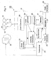
- the base station also broadcasts in its transmissions information about the GPS (or like) satellite signals, including identification of the satellites within its view, Doppler offsets of the signals from those satellites, messages transmitted by the satellites and other information that may be useful in processing satellite signals. This will assist the rovers in acquiring and tracking the satellite signals even in very weak-signal environments. The information will also permit the rovers to improve their positional accuracies as is known in the art. This information may be broadcast by modulation of the broadcast ranging signal.
- Each rover has a unique identification, which may be incorporated in its transmissions to the base station 10.
- the base station may incorporate a rover's identification in its transmissions intended primarily for that rover.
- the unique identification for transmissions to the base station may be a pseudo-random code, such that the base station can readily separate the signals received from the respective rovers. Further, the base station may use the code in the received signals for rover clock error and/or rover range determination.
- Each rover may also use the base station broadcasts to reduce clock frequency errors, by synchronizing the rover's clock to the broadcast signal, at least until sufficient satellites are visible to train the rover's clocks to the satellite transmissions.
- the Doppler error due to the rover's motion will be less than that from a single satellite, and the rover can more easily train its clock to the timing information in the base station's transmission.
- the rover can correct for its motion and create a more accurate clock model using the satellite signals.
- both the base station 10 and the rovers 12 can transmit and receive simultaneously, for example, by using different carrier frequencies. This would increase the complexity of the rovers but would provide a better time transfer capability and provide more signal energy to assist the rovers in acquiring the base station signals in poor signal environments.
- the most significant ranging error from a terrestrial based transmission is multipath.
- a known multipath mitigation technique will be employed, which can reduce this error.
- proper antenna design should be used for the base station and rover antennas, as well as proper siting of the base station antenna to attenuate reflections without attenuating the desired signals.
- the rover's antennas for receiving the satellite signals and the base station signals should have the same lateral position. This can be accomplished, for example, by placing a whip antenna for the base station signals in the center of a patch antenna used for the reception of satellite signals.
- each rover compute its own position it is also possible for it to transmit back to the base station its raw measurement data, and have the base station perform the position calculations. The base station then transmits back to the rover the rover's position. As discussed, the base station may transmit the information on the quadrature phase of the base station ranging signal, or using other transmissions.
Landscapes
- Engineering & Computer Science (AREA)
- Radar, Positioning & Navigation (AREA)
- Remote Sensing (AREA)
- Computer Networks & Wireless Communication (AREA)
- Physics & Mathematics (AREA)
- General Physics & Mathematics (AREA)
- Position Fixing By Use Of Radio Waves (AREA)
Claims (21)
- System zur Verbesserung der Positionsbestimmung durch Rover-Empfänger (12) unter Verwendung eines Satellitenentfernungsmesssystems zur Ermittlung ihrer Standorte, wobei das Satellitenentfernungsmesssystem eine Vielzahl von erdumlaufenden Satelliten (14) umfasst, wobei das System zur Verbesserung der Positionsbestimmung aufweist:A. eine Basisstation (10), umfassend
einen oder mehrere Receiver (18) zum Empfang und zur Verarbeitung von Entfernungsmesssignalen von mehrfachen erdumlaufenden Satelliten (14) und zur Bestimmung von die zeitliche Steuerung des Satellitenentfernungsmesssystems am Standort der Basisstation (10) betreffenden Informationen, und einen Sender zum Senden eines Entfernungsmesssignals, das dem Standort der Basisstation (10) zugrunde liegt, wobei das Entfernungsmesssignal der Basisstation mit der Zeit des Satelliten¬entfernungsmesssystems an der Basisstation (10) synchronisiert ist, wobei die Basisstation (10) eine Vielzahl von Antennen (16) umfasst;B. einen oder mehrere Rover-Empfänger, wobei jeder Rover-Empfänger (12) umfasst
mindestens einen Receiver (34) zum Empfang und zur Verarbeitung der von den erdumlaufenden Satelliten (14) gesendeten Entfernungsmesssignale und des Entfernungsmesssignals von der Basisstation (10);
dadurch gekennzeichnet, dass
jeder Rover-Empfänger (12) einen Sender aufweist, der zu der Basisstation (10) ein Rücksignal sendet als Reaktion auf das von der Basisstation (10) empfangene Entfernungsmesssignal, das Rücksignal mit der Zeit des Satellitenentfernungsmesssystems am Standort des Rover-Empfängers (12) abgeglichen wird, wobei die Basisstation (10) den Bereich des Rover-Empfängers (12) von der Basisstation (10) und die Richtung des Rover-Empfängers (12) auf der Basis des empfangenen Rücksignals bestimmt. - System nach Anspruch 1, bei welchem die Basisstation (10) Codes und Träger der Entfernungsmesssignale mit Codes und Trägern empfangener Satellitensignale synchronisiert.
- System nach Anspruch 2, bei welchem die Basisstation (10) an die Rover-Empfänger (12) Informationen über die sichtbaren, erdumlaufenden Satelliten (14) sendet.
- System nach Anspruch 3, wobei die Basisstation (10) des Weiteren Informationen über die Eigenschaften der Satellitensignale sendet.
- System nach Anspruch 4, wobei die Basisstation (10) die Informationen durch Modulation der Informationen auf das Entfernungsmesssignal sendet.
- System nach Anspruch 5, wobei die Basisstation (10) die Informationen auf einem Quadraturkanal des Entfernungsmesssignals sendet.
- Verfahren zur Verbesserung der Positionsbestimmung durch Rover-Empfänger (12), die ein Satellitenentfernungsmesssystem zur Standortbestimmung verwenden, das Satellitenentfernungsmesssystem eine Vielzahl von erdumlaufenden Satelliten (14) einschließt, wobei das Verfahren die Schritte umfasst:A. Bereitstellen einer ortsfesten Basisstation (10) mit einem Receiver zum Empfang von durch mehrfache erdumlaufende Satelliten (14) gesendeten Entfernungsmesssignalen und durch die Rover-Empfänger (12) gesendeten Übertragungssignalen;B. Bereitstellen an der Basisstation (10) eines Sender-Empfängers zum Senden von Entfernungsmesssignalen an die Rover-Empfänger (12), wobei die Signale mit der Zeit des Satellitenentfernungsmesssystems an der Basisstation (10) synchronisiert sind, wodurch die Basisstation (10) als eine Entfernungsbestimmungsbasis für die Standortberechnung der Rover-Empfänger (12) dient, und zum Empfangen von Signalen von den Rover-Empfängern (12);C. Senden eines Taktsignals von der Basisstation (10) an die Rover-Empfänger (12);D. Senden von reflektierten Taktsignalen durch die jeweiligen Rover-Empfänger (12) als Reaktion auf das von der Basisstation (10) empfangene Taktsignal, wobei die Rover-Empfänger (12) die reflektierten Taktsignale nach vorgegebenen Laufzeiten senden; undE. Verwenden der verstrichenen Zeit der reflektierten Zeitsteuerungsübertragung und der vorgegebenen Laufzeit, um den Bereich von der Basisstation (10) zu dem Rover-Empfänger (12) zu berechnen.
- Verfahren nach Anspruch 7, wobei die Basisstation (10) die Azimutrichtung von der Basisstation (10) zu dem Rover-Empfänger (12) erfasst und diese Informationen zum Verfeinern der Positionsschätzung des Rover-Empfängers (12) nutzt, um den Rover-Empfänger (12) beim Berechnen seiner Position zu unterstützen.
- Verfahren nach Anspruch 7, wobeiA. jedes durch die Basisstation (10) gesendete Taktsignal einen gegebenen Rover-Empfänger (12) erkennt; undB. jeder Rover-Empfänger (12) das reflektierte Taktsignal nur als Reaktion auf den Empfang des Taktsignals, das diesen Rover-Empfänger (12) erkennt, sendet.
- Verfahren nach Anspruch 7, wobei die jeweiligen Rover-Empfänger (12) reflektierte Taktsignale in vorher zugewiesenen zeitlichen Zuordnungen senden.
- Verfahren nach Anspruch 7, wobei die durch die Basisstation gesendeten Entfernungsmesssignale:i. das gleiche Format aufweisen wie die von den erdumlaufenden Satelliten (14) gesendeten Entfernungsmesssignale; undii. mit der Zeit des Satellitenentfernungsmesssystems an dem Standort der Basisstation (10) synchronisiert sind.
- Verfahren nach Anspruch 11, bei dem Codes und Träger in den Entfernungsmesssignalen mit Codes und Trägern in empfangenen Satellitensignalen synchronisiert sind.
- Verfahren nach Anspruch 12, bei dem die Taktsignale die Modulationsform der von der Basisstation (10) übertragenen Entfernungsmesssignale aufweisen.
- Verfahren nach Anspruch 7, umfassend den Schritt einer Berechnung der Zeit des Entfernungsmesssystems an dem Standort des Rover-Empfängers (12) durch Zweiweg-Zeitübertragung.
- System nach Anspruch 1, wobei
die von der Basisstation (10) gesendeten Informationen die Bereiche der jeweiligen Rover-Empfänger (12) sind. - System nach Anspruch 1, wobei
die Receiver der Basisstation (10) Richtungen der jeweiligen Rover-Empfänger (12) basierend auf Phasenunterschieden in den Signalen bestimmen, die von den Rover-Empfängern (12) in zwei oder mehreren der Antennen (16) empfangen werden; und
die von der Basisstation (10) gesendeten Informationen die Richtungen der jeweiligen Rover-Empfänger (12) sind. - System nach Anspruch 16, wobei
die Receiver der Basisstation (10) das Azimut der jeweiligen Rover-Empfänger (12) basierend auf Phasenunterschieden in den Signalen berechnen, die von den Rover-Empfängern (12) in zwei oder mehreren der Antennen (16) empfangen werden; und
die von der Basisstation (10) übertragenen Informationen das Azimut der jeweiligen Rover-Empfänger (12) sind. - System nach Anspruch 17, wobei
die Basisstation (10) Richtungsinformationen der Rover-Empfänger getrennt oder als Teil des Entfernungsmesssignals sendet; und
der eine oder mehrere Rover-Empfänger (12) jeweils Entfernungsmesssignale von den erdumlaufenden Satelliten (14) und das Entfernungsmesssignal sowie Richtungsinformationen von der Basisstation (10) empfangen und verarbeiten und ihre jeweiligen Positionen und zeitliche Steuerung aus zumindest den von der Basisstation (10) empfangenen Entfernungsmesssignalen und Richtungsinformationen bestimmen, und
Signale an die Basisstation übertragen, die mit der Zeit des Satelliten- oder Basisstationsentfernungsmesssystems an dem Standort des Rover-Empfängers (12) abgeglichen sind. - System nach Anspruch 18, wobei die Receiver der Basisstation Bereiche für die jeweiligen Rover-Empfänger basierend auf den von den Rover-Empfängern (12) empfangenen Signalen bestimmen und der Basisstationssender die Bereiche an die jeweiligen Rover-Empfänger sendet.
- System nach Anspruch 19, wobei die Receiver der Rover-Empfänger die Zeit der Rover-Empfänger mit der zeitlichen Steuerung in den Entfernungsmesssignalen der Basisstation abgleichen, um den Empfang der Satellitensignale zu unterstützen.
- System nach Anspruch 18, wobei die Vielzahl von Antennen (16) eine Antenne zum Empfang von Satellitensignalen und mehrfache, gemeinsam installierte Antennen zum Empfang von durch den Rover-Empfänger (12) gesendeten Signalen umfasst.
Applications Claiming Priority (2)
| Application Number | Priority Date | Filing Date | Title |
|---|---|---|---|
| US78742806P | 2006-03-30 | 2006-03-30 | |
| PCT/CA2007/000516 WO2007112559A1 (en) | 2006-03-30 | 2007-03-30 | Enhancement of gnss position determination in poor signal propagation environments |
Publications (3)
| Publication Number | Publication Date |
|---|---|
| EP1999481A1 EP1999481A1 (de) | 2008-12-10 |
| EP1999481A4 EP1999481A4 (de) | 2010-11-24 |
| EP1999481B1 true EP1999481B1 (de) | 2016-01-06 |
Family
ID=38563036
Family Applications (1)
| Application Number | Title | Priority Date | Filing Date |
|---|---|---|---|
| EP07719448.8A Active EP1999481B1 (de) | 2006-03-30 | 2007-03-30 | Verbesserung der gnss-positionsbestimmung in umgebungen mit schlechter signalausbreitung |
Country Status (4)
| Country | Link |
|---|---|
| US (1) | US7656349B2 (de) |
| EP (1) | EP1999481B1 (de) |
| CA (1) | CA2647555C (de) |
| WO (1) | WO2007112559A1 (de) |
Cited By (1)
| Publication number | Priority date | Publication date | Assignee | Title |
|---|---|---|---|---|
| CN110146906A (zh) * | 2019-05-23 | 2019-08-20 | 中国科学院国家授时中心 | 基于单差载波相位观测值的远程时间传递方法 |
Families Citing this family (14)
| Publication number | Priority date | Publication date | Assignee | Title |
|---|---|---|---|---|
| US8169982B2 (en) | 2005-08-10 | 2012-05-01 | Qualcomm Incorporated | Method and apparatus for creating a fingerprint for a wireless network |
| US8159397B2 (en) * | 2006-03-30 | 2012-04-17 | Novatel Inc. | System for determining position using two way time transfer signals |
| US20090098885A1 (en) | 2007-10-12 | 2009-04-16 | Qualcomm Incorporated | System and method for storing information to locate a femto cell |
| CN101843029B (zh) | 2007-11-02 | 2013-01-09 | 诺瓦特公司 | 用于经由网络分发精确时间和频率的系统和方法 |
| US9253653B2 (en) | 2007-11-09 | 2016-02-02 | Qualcomm Incorporated | Access point configuration based on received access point signals |
| JP5383693B2 (ja) * | 2007-11-13 | 2014-01-08 | ノヴァテル インコーポレイテッド | ネットワークにわたって位置を定めるためのシステム |
| CN103777217B (zh) | 2008-05-22 | 2017-03-01 | 诺瓦特公司 | 用于减少首次定位时间的gnss接收器和系统 |
| US20100164789A1 (en) * | 2008-12-30 | 2010-07-01 | Gm Global Technology Operations, Inc. | Measurement Level Integration of GPS and Other Range and Bearing Measurement-Capable Sensors for Ubiquitous Positioning Capability |
| US8838096B2 (en) | 2009-05-29 | 2014-09-16 | Qualcomm Incorporated | Non-macro cell search integrated with macro-cellular RF carrier monitoring |
| US8923892B2 (en) | 2010-05-14 | 2014-12-30 | Qualcomm Incorporated | Method and apparatus for updating femtocell proximity information |
| US8681045B2 (en) * | 2010-07-09 | 2014-03-25 | Intel Mobile Communications GmbH | Hybrid satellite positioning receiver |
| FR2992069B1 (fr) * | 2012-06-15 | 2016-11-18 | Thales Sa | Systeme de radio-navigation par satellite a architecture deportee |
| PL2980607T3 (pl) * | 2014-07-31 | 2020-03-31 | Fraunhofer-Gesellschaft zur Förderung der angewandten Forschung e.V. | System wieloantenowego odbiornika GNSS do zwiększania prawdopodobieństwa niezakłóconej linii widzenia |
| US11432109B2 (en) * | 2019-11-27 | 2022-08-30 | Qualcomm Incorporated | Positioning of vehicles and pedestrians leveraging ranging signal |
Family Cites Families (12)
| Publication number | Priority date | Publication date | Assignee | Title |
|---|---|---|---|---|
| US3742498A (en) * | 1970-05-06 | 1973-06-26 | Itt | Synchronization and position location system |
| FR2735240B1 (fr) * | 1995-06-06 | 1998-01-30 | Soc Et Rech Et Const Electroni | Procede et dispositif pour la determination precise d'un point masque par radiolocalisation satellitaire. |
| AU2246497A (en) | 1996-02-01 | 1997-08-22 | Stanford Telecommunications, Inc. | Radio navigation system using out-of-band pseudolites |
| US5928306A (en) | 1996-08-22 | 1999-07-27 | Trimble Navigation Limited | Method and apparatus for automated differential GPS processing |
| US5786773A (en) * | 1996-10-02 | 1998-07-28 | The Boeing Company | Local-area augmentation system for satellite navigation precision-approach system |
| US6101178A (en) * | 1997-07-10 | 2000-08-08 | Ksi Inc. | Pseudolite-augmented GPS for locating wireless telephones |
| US6268824B1 (en) | 1998-09-18 | 2001-07-31 | Topcon Positioning Systems, Inc. | Methods and apparatuses of positioning a mobile user in a system of satellite differential navigation |
| GB9920286D0 (en) * | 1999-08-27 | 1999-10-27 | Roke Manor Research | Improvements in or relating to satellite navigation |
| EP1247074A1 (de) | 2000-01-05 | 2002-10-09 | The Johns Hopkins University | Genaues integriertes strassenpositonierungssystem mit gps |
| US6882314B2 (en) * | 2000-01-24 | 2005-04-19 | Novariant, Inc. | Carrier-based differential-position determination using multi-frequency pseudolites |
| US6556942B1 (en) * | 2000-09-29 | 2003-04-29 | Ut-Battelle, Llc | Short range spread-spectrum radiolocation system and method |
| EP1550241B1 (de) * | 2002-09-23 | 2016-03-23 | Topcon GPS LLC | Positionsschätzung unter verwendung eines netzwerks von gps-empfängern |
-
2007
- 2007-03-30 CA CA2647555A patent/CA2647555C/en active Active
- 2007-03-30 US US11/694,368 patent/US7656349B2/en active Active
- 2007-03-30 WO PCT/CA2007/000516 patent/WO2007112559A1/en not_active Ceased
- 2007-03-30 EP EP07719448.8A patent/EP1999481B1/de active Active
Cited By (1)
| Publication number | Priority date | Publication date | Assignee | Title |
|---|---|---|---|---|
| CN110146906A (zh) * | 2019-05-23 | 2019-08-20 | 中国科学院国家授时中心 | 基于单差载波相位观测值的远程时间传递方法 |
Also Published As
| Publication number | Publication date |
|---|---|
| EP1999481A4 (de) | 2010-11-24 |
| CA2647555A1 (en) | 2007-10-11 |
| US20070241960A1 (en) | 2007-10-18 |
| CA2647555C (en) | 2014-02-11 |
| EP1999481A1 (de) | 2008-12-10 |
| US7656349B2 (en) | 2010-02-02 |
| WO2007112559A1 (en) | 2007-10-11 |
Similar Documents
| Publication | Publication Date | Title |
|---|---|---|
| EP1999481B1 (de) | Verbesserung der gnss-positionsbestimmung in umgebungen mit schlechter signalausbreitung | |
| CA2784617C (en) | System for determining position using two way time transfer signals | |
| CA2066831C (en) | Vehicle tracking system employing global positioning system (gps) satellites | |
| CA2424978C (en) | System for determining the position of an object | |
| US7869813B2 (en) | Position detection with frequency smoothing | |
| US7616682B2 (en) | Method and device for chronologically synchronizing a location network | |
| US6646603B2 (en) | Method of providing an estimate of a location | |
| US9851429B2 (en) | Terrestrial position and timing system | |
| US5995043A (en) | Aircraft satellite navigation precision-approach system including CDMA datalink | |
| US20130063302A1 (en) | Coding in a wide area positioning system (waps) | |
| US20040008138A1 (en) | Apparatus and method of position determination using shared information | |
| AU2016202845A1 (en) | Coding in a wide area positioning system (WAPS) | |
| EP4118459A1 (de) | Gnss-repeater-architektur und standortlokalisationsverfahren für innenpositionssysteme mit niedrigeren frequenzen als gnss-signale | |
| WO2003005055A1 (en) | Gps receiver and method for determining position of a wireless terminal | |
| US7403155B2 (en) | Method for the accelerated acquisition of satellite signals | |
| HK1126067A (en) | Method and system for locating a mobile subscriber in a cdma communication system |
Legal Events
| Date | Code | Title | Description |
|---|---|---|---|
| PUAI | Public reference made under article 153(3) epc to a published international application that has entered the european phase |
Free format text: ORIGINAL CODE: 0009012 |
|
| 17P | Request for examination filed |
Effective date: 20080922 |
|
| AK | Designated contracting states |
Kind code of ref document: A1 Designated state(s): AT BE BG CH CY CZ DE DK EE ES FI FR GB GR HU IE IS IT LI LT LU LV MC MT NL PL PT RO SE SI SK TR |
|
| AX | Request for extension of the european patent |
Extension state: AL BA HR MK RS |
|
| RIN1 | Information on inventor provided before grant (corrected) |
Inventor name: FELLER, WALTER J. |
|
| A4 | Supplementary search report drawn up and despatched |
Effective date: 20101021 |
|
| 17Q | First examination report despatched |
Effective date: 20110811 |
|
| REG | Reference to a national code |
Ref country code: DE Ref legal event code: R079 Ref document number: 602007044450 Country of ref document: DE Free format text: PREVIOUS MAIN CLASS: G01S0005140000 Ipc: G01S0019050000 |
|
| GRAP | Despatch of communication of intention to grant a patent |
Free format text: ORIGINAL CODE: EPIDOSNIGR1 |
|
| RIC1 | Information provided on ipc code assigned before grant |
Ipc: G01S 19/25 20100101ALI20150625BHEP Ipc: G01S 19/05 20100101AFI20150625BHEP Ipc: G01S 19/06 20100101ALI20150625BHEP Ipc: G01S 19/23 20100101ALI20150625BHEP Ipc: G01S 19/12 20100101ALI20150625BHEP |
|
| INTG | Intention to grant announced |
Effective date: 20150723 |
|
| GRAS | Grant fee paid |
Free format text: ORIGINAL CODE: EPIDOSNIGR3 |
|
| GRAA | (expected) grant |
Free format text: ORIGINAL CODE: 0009210 |
|
| AK | Designated contracting states |
Kind code of ref document: B1 Designated state(s): AT BE BG CH CY CZ DE DK EE ES FI FR GB GR HU IE IS IT LI LT LU LV MC MT NL PL PT RO SE SI SK TR |
|
| AX | Request for extension of the european patent |
Extension state: AL BA HR MK RS |
|
| REG | Reference to a national code |
Ref country code: GB Ref legal event code: FG4D |
|
| REG | Reference to a national code |
Ref country code: CH Ref legal event code: EP |
|
| REG | Reference to a national code |
Ref country code: CH Ref legal event code: NV Representative=s name: FELBER AND PARTNER AG, CH |
|
| REG | Reference to a national code |
Ref country code: IE Ref legal event code: FG4D |
|
| REG | Reference to a national code |
Ref country code: AT Ref legal event code: REF Ref document number: 769302 Country of ref document: AT Kind code of ref document: T Effective date: 20160215 |
|
| REG | Reference to a national code |
Ref country code: DE Ref legal event code: R096 Ref document number: 602007044450 Country of ref document: DE |
|
| REG | Reference to a national code |
Ref country code: FR Ref legal event code: PLFP Year of fee payment: 10 |
|
| REG | Reference to a national code |
Ref country code: LT Ref legal event code: MG4D |
|
| REG | Reference to a national code |
Ref country code: NL Ref legal event code: MP Effective date: 20160106 |
|
| REG | Reference to a national code |
Ref country code: AT Ref legal event code: MK05 Ref document number: 769302 Country of ref document: AT Kind code of ref document: T Effective date: 20160106 |
|
| PG25 | Lapsed in a contracting state [announced via postgrant information from national office to epo] |
Ref country code: NL Free format text: LAPSE BECAUSE OF FAILURE TO SUBMIT A TRANSLATION OF THE DESCRIPTION OR TO PAY THE FEE WITHIN THE PRESCRIBED TIME-LIMIT Effective date: 20160106 |
|
| PG25 | Lapsed in a contracting state [announced via postgrant information from national office to epo] |
Ref country code: IT Free format text: LAPSE BECAUSE OF FAILURE TO SUBMIT A TRANSLATION OF THE DESCRIPTION OR TO PAY THE FEE WITHIN THE PRESCRIBED TIME-LIMIT Effective date: 20160106 Ref country code: ES Free format text: LAPSE BECAUSE OF FAILURE TO SUBMIT A TRANSLATION OF THE DESCRIPTION OR TO PAY THE FEE WITHIN THE PRESCRIBED TIME-LIMIT Effective date: 20160106 Ref country code: GR Free format text: LAPSE BECAUSE OF FAILURE TO SUBMIT A TRANSLATION OF THE DESCRIPTION OR TO PAY THE FEE WITHIN THE PRESCRIBED TIME-LIMIT Effective date: 20160407 Ref country code: FI Free format text: LAPSE BECAUSE OF FAILURE TO SUBMIT A TRANSLATION OF THE DESCRIPTION OR TO PAY THE FEE WITHIN THE PRESCRIBED TIME-LIMIT Effective date: 20160106 |
|
| PG25 | Lapsed in a contracting state [announced via postgrant information from national office to epo] |
Ref country code: PL Free format text: LAPSE BECAUSE OF FAILURE TO SUBMIT A TRANSLATION OF THE DESCRIPTION OR TO PAY THE FEE WITHIN THE PRESCRIBED TIME-LIMIT Effective date: 20160106 Ref country code: IS Free format text: LAPSE BECAUSE OF FAILURE TO SUBMIT A TRANSLATION OF THE DESCRIPTION OR TO PAY THE FEE WITHIN THE PRESCRIBED TIME-LIMIT Effective date: 20160506 Ref country code: SE Free format text: LAPSE BECAUSE OF FAILURE TO SUBMIT A TRANSLATION OF THE DESCRIPTION OR TO PAY THE FEE WITHIN THE PRESCRIBED TIME-LIMIT Effective date: 20160106 Ref country code: LT Free format text: LAPSE BECAUSE OF FAILURE TO SUBMIT A TRANSLATION OF THE DESCRIPTION OR TO PAY THE FEE WITHIN THE PRESCRIBED TIME-LIMIT Effective date: 20160106 Ref country code: LV Free format text: LAPSE BECAUSE OF FAILURE TO SUBMIT A TRANSLATION OF THE DESCRIPTION OR TO PAY THE FEE WITHIN THE PRESCRIBED TIME-LIMIT Effective date: 20160106 Ref country code: PT Free format text: LAPSE BECAUSE OF FAILURE TO SUBMIT A TRANSLATION OF THE DESCRIPTION OR TO PAY THE FEE WITHIN THE PRESCRIBED TIME-LIMIT Effective date: 20160506 Ref country code: AT Free format text: LAPSE BECAUSE OF FAILURE TO SUBMIT A TRANSLATION OF THE DESCRIPTION OR TO PAY THE FEE WITHIN THE PRESCRIBED TIME-LIMIT Effective date: 20160106 |
|
| REG | Reference to a national code |
Ref country code: DE Ref legal event code: R097 Ref document number: 602007044450 Country of ref document: DE |
|
| PG25 | Lapsed in a contracting state [announced via postgrant information from national office to epo] |
Ref country code: DK Free format text: LAPSE BECAUSE OF FAILURE TO SUBMIT A TRANSLATION OF THE DESCRIPTION OR TO PAY THE FEE WITHIN THE PRESCRIBED TIME-LIMIT Effective date: 20160106 Ref country code: MC Free format text: LAPSE BECAUSE OF FAILURE TO SUBMIT A TRANSLATION OF THE DESCRIPTION OR TO PAY THE FEE WITHIN THE PRESCRIBED TIME-LIMIT Effective date: 20160106 Ref country code: EE Free format text: LAPSE BECAUSE OF FAILURE TO SUBMIT A TRANSLATION OF THE DESCRIPTION OR TO PAY THE FEE WITHIN THE PRESCRIBED TIME-LIMIT Effective date: 20160106 Ref country code: LU Free format text: LAPSE BECAUSE OF FAILURE TO SUBMIT A TRANSLATION OF THE DESCRIPTION OR TO PAY THE FEE WITHIN THE PRESCRIBED TIME-LIMIT Effective date: 20160330 |
|
| PLBE | No opposition filed within time limit |
Free format text: ORIGINAL CODE: 0009261 |
|
| STAA | Information on the status of an ep patent application or granted ep patent |
Free format text: STATUS: NO OPPOSITION FILED WITHIN TIME LIMIT |
|
| PG25 | Lapsed in a contracting state [announced via postgrant information from national office to epo] |
Ref country code: RO Free format text: LAPSE BECAUSE OF FAILURE TO SUBMIT A TRANSLATION OF THE DESCRIPTION OR TO PAY THE FEE WITHIN THE PRESCRIBED TIME-LIMIT Effective date: 20160106 Ref country code: CZ Free format text: LAPSE BECAUSE OF FAILURE TO SUBMIT A TRANSLATION OF THE DESCRIPTION OR TO PAY THE FEE WITHIN THE PRESCRIBED TIME-LIMIT Effective date: 20160106 Ref country code: SK Free format text: LAPSE BECAUSE OF FAILURE TO SUBMIT A TRANSLATION OF THE DESCRIPTION OR TO PAY THE FEE WITHIN THE PRESCRIBED TIME-LIMIT Effective date: 20160106 |
|
| 26N | No opposition filed |
Effective date: 20161007 |
|
| REG | Reference to a national code |
Ref country code: IE Ref legal event code: MM4A |
|
| PG25 | Lapsed in a contracting state [announced via postgrant information from national office to epo] |
Ref country code: IE Free format text: LAPSE BECAUSE OF NON-PAYMENT OF DUE FEES Effective date: 20160330 |
|
| PG25 | Lapsed in a contracting state [announced via postgrant information from national office to epo] |
Ref country code: SI Free format text: LAPSE BECAUSE OF FAILURE TO SUBMIT A TRANSLATION OF THE DESCRIPTION OR TO PAY THE FEE WITHIN THE PRESCRIBED TIME-LIMIT Effective date: 20160106 Ref country code: BG Free format text: LAPSE BECAUSE OF FAILURE TO SUBMIT A TRANSLATION OF THE DESCRIPTION OR TO PAY THE FEE WITHIN THE PRESCRIBED TIME-LIMIT Effective date: 20160406 |
|
| REG | Reference to a national code |
Ref country code: FR Ref legal event code: PLFP Year of fee payment: 11 |
|
| PG25 | Lapsed in a contracting state [announced via postgrant information from national office to epo] |
Ref country code: MT Free format text: LAPSE BECAUSE OF FAILURE TO SUBMIT A TRANSLATION OF THE DESCRIPTION OR TO PAY THE FEE WITHIN THE PRESCRIBED TIME-LIMIT Effective date: 20160106 |
|
| REG | Reference to a national code |
Ref country code: FR Ref legal event code: PLFP Year of fee payment: 12 |
|
| PG25 | Lapsed in a contracting state [announced via postgrant information from national office to epo] |
Ref country code: CY Free format text: LAPSE BECAUSE OF FAILURE TO SUBMIT A TRANSLATION OF THE DESCRIPTION OR TO PAY THE FEE WITHIN THE PRESCRIBED TIME-LIMIT Effective date: 20160106 Ref country code: HU Free format text: LAPSE BECAUSE OF FAILURE TO SUBMIT A TRANSLATION OF THE DESCRIPTION OR TO PAY THE FEE WITHIN THE PRESCRIBED TIME-LIMIT; INVALID AB INITIO Effective date: 20070330 |
|
| PG25 | Lapsed in a contracting state [announced via postgrant information from national office to epo] |
Ref country code: TR Free format text: LAPSE BECAUSE OF FAILURE TO SUBMIT A TRANSLATION OF THE DESCRIPTION OR TO PAY THE FEE WITHIN THE PRESCRIBED TIME-LIMIT Effective date: 20160106 Ref country code: MT Free format text: LAPSE BECAUSE OF FAILURE TO SUBMIT A TRANSLATION OF THE DESCRIPTION OR TO PAY THE FEE WITHIN THE PRESCRIBED TIME-LIMIT Effective date: 20160331 |
|
| PGFP | Annual fee paid to national office [announced via postgrant information from national office to epo] |
Ref country code: BE Payment date: 20200327 Year of fee payment: 14 |
|
| REG | Reference to a national code |
Ref country code: BE Ref legal event code: MM Effective date: 20210331 |
|
| PG25 | Lapsed in a contracting state [announced via postgrant information from national office to epo] |
Ref country code: BE Free format text: LAPSE BECAUSE OF NON-PAYMENT OF DUE FEES Effective date: 20210331 |
|
| PGFP | Annual fee paid to national office [announced via postgrant information from national office to epo] |
Ref country code: DE Payment date: 20250327 Year of fee payment: 19 |
|
| PGFP | Annual fee paid to national office [announced via postgrant information from national office to epo] |
Ref country code: FR Payment date: 20250325 Year of fee payment: 19 |
|
| PGFP | Annual fee paid to national office [announced via postgrant information from national office to epo] |
Ref country code: GB Payment date: 20250327 Year of fee payment: 19 |
|
| PGFP | Annual fee paid to national office [announced via postgrant information from national office to epo] |
Ref country code: CH Payment date: 20250401 Year of fee payment: 19 |