EP1909247A1 - Map database creating system - Google Patents
Map database creating system Download PDFInfo
- Publication number
- EP1909247A1 EP1909247A1 EP06798466A EP06798466A EP1909247A1 EP 1909247 A1 EP1909247 A1 EP 1909247A1 EP 06798466 A EP06798466 A EP 06798466A EP 06798466 A EP06798466 A EP 06798466A EP 1909247 A1 EP1909247 A1 EP 1909247A1
- Authority
- EP
- European Patent Office
- Prior art keywords
- information
- feature
- map
- database
- road
- Prior art date
- Legal status (The legal status is an assumption and is not a legal conclusion. Google has not performed a legal analysis and makes no representation as to the accuracy of the status listed.)
- Ceased
Links
Images


Classifications
-
- G—PHYSICS
- G06—COMPUTING; CALCULATING OR COUNTING
- G06T—IMAGE DATA PROCESSING OR GENERATION, IN GENERAL
- G06T11/00—2D [Two Dimensional] image generation
- G06T11/60—Editing figures and text; Combining figures or text
-
- G—PHYSICS
- G09—EDUCATION; CRYPTOGRAPHY; DISPLAY; ADVERTISING; SEALS
- G09B—EDUCATIONAL OR DEMONSTRATION APPLIANCES; APPLIANCES FOR TEACHING, OR COMMUNICATING WITH, THE BLIND, DEAF OR MUTE; MODELS; PLANETARIA; GLOBES; MAPS; DIAGRAMS
- G09B29/00—Maps; Plans; Charts; Diagrams, e.g. route diagram
-
- G—PHYSICS
- G01—MEASURING; TESTING
- G01C—MEASURING DISTANCES, LEVELS OR BEARINGS; SURVEYING; NAVIGATION; GYROSCOPIC INSTRUMENTS; PHOTOGRAMMETRY OR VIDEOGRAMMETRY
- G01C21/00—Navigation; Navigational instruments not provided for in groups G01C1/00 - G01C19/00
- G01C21/38—Electronic maps specially adapted for navigation; Updating thereof
- G01C21/3804—Creation or updating of map data
- G01C21/3807—Creation or updating of map data characterised by the type of data
- G01C21/3815—Road data
- G01C21/3822—Road feature data, e.g. slope data
-
- G—PHYSICS
- G01—MEASURING; TESTING
- G01C—MEASURING DISTANCES, LEVELS OR BEARINGS; SURVEYING; NAVIGATION; GYROSCOPIC INSTRUMENTS; PHOTOGRAMMETRY OR VIDEOGRAMMETRY
- G01C21/00—Navigation; Navigational instruments not provided for in groups G01C1/00 - G01C19/00
- G01C21/38—Electronic maps specially adapted for navigation; Updating thereof
- G01C21/3863—Structures of map data
- G01C21/387—Organisation of map data, e.g. version management or database structures
-
- G—PHYSICS
- G06—COMPUTING; CALCULATING OR COUNTING
- G06F—ELECTRIC DIGITAL DATA PROCESSING
- G06F17/00—Digital computing or data processing equipment or methods, specially adapted for specific functions
- G06F17/40—Data acquisition and logging
-
- G—PHYSICS
- G06—COMPUTING; CALCULATING OR COUNTING
- G06T—IMAGE DATA PROCESSING OR GENERATION, IN GENERAL
- G06T17/00—Three dimensional [3D] modelling, e.g. data description of 3D objects
- G06T17/05—Geographic models
-
- G—PHYSICS
- G09—EDUCATION; CRYPTOGRAPHY; DISPLAY; ADVERTISING; SEALS
- G09B—EDUCATIONAL OR DEMONSTRATION APPLIANCES; APPLIANCES FOR TEACHING, OR COMMUNICATING WITH, THE BLIND, DEAF OR MUTE; MODELS; PLANETARIA; GLOBES; MAPS; DIAGRAMS
- G09B29/00—Maps; Plans; Charts; Diagrams, e.g. route diagram
- G09B29/10—Map spot or coordinate position indicators; Map reading aids
Definitions
- the present invention relates to a system for generating an electronic map database suitable for use in a navigation system or the like, for example.
- Patent Document 1 discloses a system such as the following.
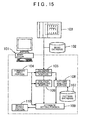
- the structure of this system is shown in FIG. 15 .
- a map data generating device 101 formed by installing a predetermined program on a general-purpose computer constitutes the nucleus of the system.
- attribute information is set in relation to each of the links in the road database 102, and thus a new map database is generated.
- attribute information is information regarding the structure, traffic regulations, and so on of each link.
- Specific examples of the attribute information include sidewalks, central dividers, overpasses, traffic lights, bridges, tunnels, pedestrian crossings, parking lots, one-way traffic, no entry, road closed, no passing, and the number of lanes.
- the map data generating device 101 includes a command input portion 104, a database referencing portion 105, a polygon generating portion 106, a pattern database 107, a pattern analysis portion 108, an attribute setting portion 109, and a result output portion 110.
- the command input portion 104 inputs a command from an operator through an operation of a keyboard, a mouse, or the like.
- the data base referencing portion 105 references the road database 102 and the aerial photograph 103 on the basis of the input command.
- the polygon generating portion 106 generates a closed figure (to be referred to hereafter as a polygon) having a predetermined surface area from each of the links defined in the road database 102.
- the pattern database 107 stores various image patterns included in the aerial photograph 103 in association with corresponding attributes.
- the pattern database 107 stores an association between the "parking lot" attribute and a pattern such as that found in a parking lot, in which short line segments forming a vehicle parking space are disposed at fixed intervals, or an association between the "no passing" attribute and a yellow line such as a center line.
- the pattern analysis portion 108 reads the aerial photograph 103 and analyzes the image patterns included therein on the basis of the pattern database 107.
- the attribute setting portion 109 sets attribute information in relation to the links in the road database 102 on the basis of an analysis result of the pattern analysis portion 108.
- the result output portion 110 receives a setting result from the attribute setting portion 109, associates the attribute information with each link, and outputs a new map database.
- Patent Document 1 Japanese Patent Application Publication No. 2003-195747 (pages 5-6 and 10-11, FIG. 3 and FIG. 17)
- a new map database is generated by associating the attribute information obtained by analyzing the aerial photograph 103 with the links in the road database 102.
- the attribute information includes sidewalks, central dividers, overpasses, traffic lights, bridges, tunnels, pedestrian crossings, parking lots, one-way traffic, no entry, road closed, no passing, and the number of lanes.
- attribute information such as one-way traffic and no entry is obtained by interpreting the content, disposition, and so on of road signs.
- a map database update is performed by determining whether or not the information stored in the map database has varied with time and reflecting the content of the variation in the map database when variation has occurred.
- the determination as to whether or not the information has varied with time is made by comparing the on-site information, such as the aerial photograph 103, with the map database, but in order to achieve this, information indicated by on-site information in a past aerial photograph 103 or the like must be inferred from the interpreted attribute information in the map database and then compared with the latest on-site information.
- a large workload is required to update the map database, leading to a reduction in efficiency, and moreover, the accuracy of the update is greatly affected by the experience and skill of the operator.
- the functions, representation method, and so on of the map database are to be modified and the amount of information required in the map database has increased, the information must be gathered anew, even if only a short period of time has elapsed since information was gathered previously from the aerial photograph 103, a survey by the measurement vehicle, and so on. As a result, information is gathered in duplicate, creating wasteful expenditure and even more inefficiency.
- map database generation, updating, and other operations are inefficient and expensive, and it is difficult to create a highly accurate, highly up-to-date map database.
- the present invention has been designed in consideration of the problems described above, and it is an object thereof to provide a map database generating system capable of generating a highly accurate, highly up-to-date map database by increasing the efficiency of operations to generate and update the map database.
- a map database generating system for achieving the object described above, is a system for generating a map database including a road network comprising a plurality of nodes having position information and a link connecting two of the nodes, and road attribute information associated with the road network.
- the map database generating system is characterized by comprising: a feature database for storing feature information relating to features existing on a road and on the periphery of the road, each feature being associated with a unique identification symbol, the feature information including disposition information expressing a spatial disposition of each feature independently of the road network, form information expressing a form of each feature, accuracy information expressing an accuracy of the information, and acquisition timing information expressing an acquisition timing of the information; output means for outputting the feature information stored in the feature database; and input means for inputting map information constituting the map database, which is generated on the basis of the feature information output by the output means.
- the term "generation" relating to the map information is a concept including both the generation of new map information and updating of the map information.
- the map database generating system includes a feature database storing feature information that indicates each feature independently of the road network, or in other words not in association with the nodes and links constituting the road network, in a near-real condition by means of the spatial disposition, form and so on of the feature.
- the map database generating system generates the map information constituting the map database on the basis of the feature information stored in the feature database.
- the map information constituting the map database is generated on the basis of the feature information stored in the feature database.
- the feature information stored in the feature database includes the accuracy information and the acquisition timing information, and therefore plural feature information relating to an identical feature but having a different level of accuracy or acquisition timing can be stored appropriately in the feature database.
- the appropriate feature information can therefore be selected from the duplicate plural feature information in accordance with a condition required to generate the map information, such as the accuracy or acquisition timing.
- map database generating system information relating to features existing on a road or on the periphery of the road is stored in the feature database as feature information having a fixed data format.
- automation or semi-automation of processing to generate the map information constituting the map database can be performed comparatively easily. Accordingly, the efficiency and accuracy of operations to generate and update the map database can be increased, and a highly accurate, highly up-to-date map database can be generated easily.
- extracting means are also preferably provided for extracting, as the feature information to be output by the output means, feature information that satisfies a condition required to generate the map information from the feature database on the basis of one or more of the identification symbol, the disposition information, the form information, the accuracy information and the acquisition timing information of each piece of feature information.
- the feature information that is required to generate the map information constituting the map database can be extracted from the plural feature information stored in the feature database on the basis of the information included in each piece of feature information, and output by the output means.
- operational efficiency when generating the map information can be improved, and a map database satisfying required conditions can be generated easily.
- updating means are also preferably provided for extracting feature information relating to a feature that has varied from a past feature condition from the feature database on the basis of one or more of the identification symbol, the disposition information and the form information of each piece of feature information, as well as the acquisition timing information, and for generating update information expressing the content of the variation in the extracted feature information in a manner enabling output by the output means.
- update information indicating the content of the variation in the feature information relating to features that have varied from past feature conditions can be generated on the basis of the information included in each piece of feature information and output by the output means.
- operational efficiency when updating the map database can be improved, and a highly up-to-date map database can be generated easily.
- accuracy selecting means are also preferably provided for detecting the presence of plural feature information relating to an identical feature but having different accuracy information from the feature database on the basis of one or more of the identification symbol, disposition information and form information of each piece of feature information, as well as the accuracy information, and for selecting feature information having an accuracy required to generate the map information as the feature information to be output by the output means on the basis of the accuracy information included in each piece of detected feature information.
- map information having an optimum accuracy level for generating the map information can be selected on the basis of the information included in each piece of feature information and output by the output means.
- the efficiency of an operation to update the map database can be improved, and a highly up-to-date map database can be generated easily and with an appropriate level of accuracy.
- Another map database generating system is a system for generating a map database including a road network comprising a plurality of nodes having position information and a link connecting two of the nodes, and road attribute information associated with the road network.
- the map database generating system is characterized by including: a feature database for storing feature information relating to features existing on a road and on the periphery of the road, each feature being associated with a unique identification symbol, the feature information including disposition information expressing a spatial disposition of each feature independently of the road network, form information expressing a form of each feature, accuracy information expressing an accuracy of the information, and acquisition timing information expressing an acquisition timing of the information; and map information generating means for generating map information constituting the map database on the basis of the feature information stored in the feature database.
- the map database generating system includes a feature database storing feature information indicating each feature independently of the road network in a near-real condition by means of the spatial disposition, form and so on of the feature.
- the map database generating system generates the map information constituting the map database on the basis of the feature information stored in the feature database.
- the map information constituting the map database is generated on the basis of the feature information stored in the feature database.
- the feature information stored in the feature database includes the accuracy information and the acquisition timing information, and therefore plural feature information relating to an identical feature but having a different level of accuracy or acquisition timing can be stored appropriately in the feature database.
- the map database generating system then generates the map information by selecting the appropriate feature information from the duplicate plural feature information in accordance with an accuracy or acquisition timing condition required to generate the map information. Hence, processing efficiency when generating the map database can be improved, and a highly up-to-date map database can be generated easily and with an appropriate level of accuracy.
- extracting means are also preferably provided for extracting feature information that satisfies a condition required to generate the map information from the feature database on the basis of one or more of the identification symbol, the disposition information, the form information, the accuracy information and the acquisition timing information of each piece of feature information.
- the map information generating means preferably generate the map information on the basis of the feature information extracted by the extracting means.
- the feature information required to generate the map information constituting the map database can be extracted from the plural feature information stored in the feature database on the basis of the information included in each piece of feature information.
- processing efficiency when generating the map information can be improved, and a map database satisfying required conditions can be generated easily.
- updating means are also preferably provided for extracting feature information relating to a feature that has varied from a past feature condition from the feature database on the basis of one or more of the identification symbol, the disposition information and the form information of each piece of feature information, as well as the acquisition timing information, and for generating update information expressing the content of the variation in the extracted feature information.
- the map information generating means preferably update the map information on the basis of the update information.
- the map database generating system can generate update information indicating the content of variation in the feature information relating to a feature that has varied from a past feature condition on the basis of the information included in each piece of feature information, and update the map information on the basis of the update information.
- accuracy selecting means are also preferably provided for detecting the presence of plural feature information relating to an identical feature but having different accuracy information from the feature database on the basis of one or more of the identification symbol, the disposition information and the form information of each piece of feature information, as well as the accuracy information, and for selecting feature information having an accuracy required to generate the map information on the basis of the accuracy information included in each piece of detected feature information.
- the map information generating means preferably generate the map information on the basis of the feature information selected by the accuracy selecting means.
- the map database generating system can select feature information having an optimum accuracy level for generating the map information on the basis of the information included in each piece of feature information when plural feature information relating to the same feature but having different accuracy information exists, and generate the map information on the basis of the selected feature information.
- processing efficiency when updating or modifying the map database can be improved, and a highly up-to-date map database can be generated easily and with an appropriate level of accuracy.
- identification symbols having at least one part in common are preferably allocated to feature information relating to an identical feature.
- identical features can be extracted easily on the basis of the shared part of the identification symbols of the feature information.
- feature information relating to features that have varied from past feature conditions can be extracted easily on the basis of whether or not identification symbols having at least one part in common have been allocated to two or more pieces of feature information having different acquisition timing information.
- the features stored as the feature information preferably include one or more of a painted feature provided on a road, a traffic regulation feature expressing a traffic regulation, and a road area defining feature defining a road area.
- the feature information required to generate the map information can be stored in advance in the feature database in accordance with the content of the map database.
- the road attribute information preferably includes one or more of point attribute information associated with a point on the road network, section attribute information associated with a fixed section of the road network, and route attribute information associated with a single node on the road network and one or more links connected to the node.
- a map database in which the road attribute information is associated appropriately with the road network in accordance with the properties of the information can be generated.
- the map database is preferably a map database used in a car navigation system.
- a map database generating method is a method for generating a map database including a road network comprising a plurality of nodes having position information and a link connecting two of the nodes, and road attribute information associated with the road network.
- the method employs a feature database for storing feature information relating to features existing on a road and on the periphery of the road, each feature being associated with a unique identification symbol, the feature information including disposition information expressing a spatial disposition of each feature independently of the road network, form information expressing a form of each feature, accuracy information expressing an accuracy of the information, and acquisition timing information expressing an acquisition timing of the information.
- the map database generating method is characterized by comprising the steps of: outputting the feature information stored in the feature database; and receiving input of map information constituting the map database, which is generated on the basis of the feature information output in the outputting step.
- the efficiency of operations for generating and updating the map database or an operation for modifying the functions, representation method, and so on of the map database can be increased, and a highly accurate, highly up-to-date map database can be generated easily.
- Another map database generating method is a method for generating a map database including a road network comprising a plurality of nodes having position information and a link connecting two of the nodes, and road attribute information associated with the road network.
- the method employs a feature database for storing feature information relating to features existing on a road and on the periphery of the road, each feature being associated with a unique identification symbol, the feature information including disposition information expressing a spatial disposition of each feature independently of the road network, form information expressing a form of each feature, accuracy information expressing an accuracy of the information, and acquisition timing information expressing an acquisition timing of the information.
- the map database generating method is characterized in that map information constituting the map database is generated on the basis of the feature information stored in the feature database.
- the efficiency of processing for generating and updating the map database or processing for modifying the functions, representation method, and so on of the map database can be increased, and a highly accurate, highly up-to-date map database can be generated easily.
- FIG. 1 is an illustrative view showing the schematic structure of a map database generating system according to this embodiment.
- This map database generating system is a support system for supporting the generation of a map database 3 by an operator.
- the map database generating system includes a feature database 2, a map database 3, and a system main body 1 formed by installing a program for realizing the functions of various means to be described below on a general-purpose computer 4 that is connected accessibly to the feature database 2 and the map database 3.
- the system main body 1 is constituted by input means 5, feature information extracting means 6, output information generating means 7, output means 8, and a map information generation working area 9.
- the structure of each part of the map database generating system will be described in detail below.
- the feature database 2 is a database storing information regarding features existing on roads and on the periphery of the roads as feature information F, which is associated with an identification symbol IDf unique to each feature.
- FIG. 2 is a conceptual diagram illustrating a part of the content of the feature database 2.
- the feature database 2 is basically a database created by turning information regarding features existing on roads and on the periphery of the roads into data that faithfully represent on-site conditions on the basis of sourcing information.
- each piece of feature information F in the feature database 2 is defined independently of a road network R constituted by nodes N and links L. Further, each piece of feature information F includes disposition information F1, form information F2, and sourcing information F3. As shown in FIG.
- examples of the features stored in the feature database 2 as the feature information F include painted features provided on roads such as painted lane boundaries 11, painted direction arrows 14, painted alphanumerical characters 15, and painted symbols.
- the features also include traffic regulation features expressing traffic regulations, such as road signs 10 (in FIG. 2 , a no entry road sign 10a and a speed restriction road sign 10b are shown), traffic lights, crossing bars, stop lines 12, and the painted direction arrows 14.
- the features also include road area defining features defining road areas, such as the painted lane boundaries 11, central dividers, curbs, safety fences, buildings, and bodies of water.
- Other examples of the features include manholes, emergency telephones, pedestrian crossings 13, tunnels, bridges, rail track, and elevated walkways.
- FIG. 2 shows only a small part of the features, and the features illustrated in FIG. 2 have been allocated reference numerals.
- the unit of a single feature may be set arbitrarily, but is preferably set at a minimum unit, taking into account the function of the feature.
- the identification symbol IDf is a unique symbol allocated to each feature.
- common identification symbols IDf are allocated to feature information F relating to identical features based on different sourcing source information D (see FIG. 4 ).
- the common identification symbol IDf is preferably a symbol in which only the final digits differ, for example.
- the identification symbol ID shown in FIG. 1 is an example, and here, identical features are indicated by an identification symbol IDf in which the first five digits, i.e. "A0001" or the like, are shared and only the final three digits following the "-" symbol, i.e. "003" or the like, differ.
- a common identification symbol IDf is allocated to the feature information F of a feature that has not varied from the condition of the feature represented by the past feature information F.
- a new identification symbol IDf is allocated to feature information F relating to a newly added feature.
- the identification symbol IDf of feature information F relating to a feature that has been removed is invalidated.
- a new identification symbol IDf which is different to the feature information F prior to modification is allocated to the new feature information F following modification, and the identification symbol IDf of the feature information F prior to modification is invalidated.
- features that have been added, removed, or modified (added and removed) will all be referred to as “features that have varied from past feature conditions”, and the addition, removal, or modification (addition and removal) of such a feature will be referred to as "variation in the condition of the feature”.
- variation in the condition of the feature is determined by comparing the absolute coordinate region in which the new sourcing source information D is obtained with the past feature information F stored in the feature database 2 in relation to the same region. Further, past feature information F is determined on the basis of acquisition timing information F3b within the sourcing information F3.
- the sourcing source information D is information indicating on-site conditions, such as an aerial photograph, measurement vehicle information, and various types of drawings.
- the disposition information F1 is information indicating the spatial position of each feature independently of the road network in terms of points, lines, planes and the like on absolute coordinates represented by longitude and latitude.
- the disposition information F 1 indicates the position of a point representing the position of features such as road signs 10, traffic lights, manholes, emergency telephones, and crossing bars.
- the disposition information F1 also indicates the position of a line (polyline) representing the central shape of features such as painted lane boundaries 11, central dividers, curbs, safety fences, stop lines 12, pedestrian crossings 13, tunnels, and rail track.
- the disposition information F1 also indicates the disposition of a plane (polygon) representing the region of features such as painted direction arrows 14, painted alphanumerical characters 15, painted symbols, overpasses, buildings, and bodies of water.
- the form information F2 is information indicating the form of each feature, such as the type, shape, color, and size.
- the form information F2 includes information relating to the type, or in other words the content, of the road sign 10, the orientation of the road sign 10, the height of the road sign 10 from the road surface, the size of the road sign 10, and so on.
- the form information F2 includes information relating to the type of line, the planar (polygon) form, the color, the width, the presence or absence of surface projection, and so on.
- the form information F2 includes information relating to the planar (polygon) form, width, and so on.
- the form information F2 includes information relating to the planar (polygon) form, the line width, and so on.
- the form information F2 includes information relating to the type of arrow, or in other words the instructed advancement direction, the planar (polygon) form of the region in which the direction arrow is disposed, a reference point, the color, the line width, and so on.
- the form information F2 includes information relating to the content of the alphanumerical characters, the planar (polygon) form of the region in which the alphanumerical characters are disposed, a reference point, the color, the line width, and so on.
- the sourcing information F3 is information relating to the source of the information that serves as a basis when the feature information F is generated, and includes accuracy information F3a indicating the informational accuracy of the feature information F, and the acquisition timing information F3b indicating the acquisition timing of the feature information F.
- FIG. 3 shows the content of the sourcing information F3.
- the sourcing information F3 includes a source identification symbol 16, a source type 17, a source scale 18, positional accuracy 19, form accuracy 20, a sourcing date and time 21, and a feature information generation date 22 as information items.
- the source identification symbol 16 is a unique symbol representing the sourcing source information D (see FIG. 4 ).
- the sourcing source information D is an aerial photograph, a drawing or the like, for example, a different symbol is allocated to each photograph or drawing, and when the sourcing source information D is a moving image generated by a measurement vehicle or as a result of an on-site survey, a different symbol is allocated to each file.
- the source type 17 denotes the type of the sourcing source information D from which the feature information F is generated.
- the source type 17 may be 1: an aerial photograph, 2: a measurement vehicle, 3: a technical drawing, 4: an on-site survey, 5: a satellite photograph, 6: a town planning map, 7: a national land map, 8: a residential map, and so on.
- the source scale 18 is the scale of the drawing or the like constituting the sourcing source information D. Note that when a moving image or the like in which the concept of scale does not exist is the sourcing source information D, information relating to the source scale 18 does not exist.
- the positional accuracy 19 is positional accuracy information relating to the disposition of the feature information F on absolute coordinates. Here, the positional accuracy 19 is calculated on the basis of the source type 17, the source scale 18, and so on, and is expressed in units of [cm].
- the form accuracy 20 is accuracy information relating to the shape, size and so on in the information constituting the form information F2 of the feature information F.
- the form accuracy 20 is expressed by an integer value indicating a level set on the basis of the source type 17, the source scale 18, and so on.
- the sourcing date and time 21 is information indicating the date and time at which the sourcing source information D is obtained. In the case of an aerial photograph, a moving image produced by a measurement vehicle, and so on, for example, the date and time at which the photograph or image was captured is used as the sourcing date and time 21, and in the case of a drawing or the like, the date and time at which the drawing was created is used as the sourcing date and time 21.
- the feature information generation date 22 is information indicating the date on which the feature information F was generated on the basis of the sourcing source information D.
- the source type 17, the source scale 18, the positional accuracy 19, and the form accuracy 20 constitute the accuracy information F3a
- the sourcing date and time 21 and the feature information generation date 22 constitute the acquisition timing information F3b.
- FIG. 4 is an illustrative view showing the schematic structure of a feature database generating system 23 for generating the feature database 2 described above.
- the feature database generating system 23 is a support system for supporting the generation and updating of the feature database 2 by an operator.
- the feature database generating system 23 is formed by installing a program for realizing the functions of various means to be described below on a general-purpose computer 24 connected accessibly to the feature database 2.
- the feature database generating system 23 includes sourcing source information obtaining means 25, feature information generation supporting means 26, output means 27, input means 28, and a feature information generation working area 29.
- the sourcing source information obtaining means 25 are means for obtaining the sourcing source information D, such as an aerial photograph, measurement vehicle information, and various types of drawings.
- the sourcing source information obtaining means 25 are constituted by a recording media drive, a communication port or the like for reading data into the computer 24.
- the input means 28 are means used by the operator to input commands, information and so on into the computer 24 of the feature database generating system 23.
- the input means 28 are constituted by a keyboard 24b of the computer 24, a mouse, not shown in the drawing, or similar.
- the operator uses the input means 28 to input commands or information for generating the feature information F, including new generation and updating, on the basis of the content of the sourcing source information D output by the output means 27, the content of operation support information generated by the feature information generation supporting means 26, and so on.
- New or modified feature information F is generated in the feature information generation working area 29 in accordance with the input from the operator through the input means 28.
- the feature information generation supporting means 26 are means for supporting an operation to generate the feature information F, which is performed by the operator on the basis of the obtained sourcing source information D.
- the feature information generation supporting means 26 generate operation support information for supporting an operation to generate the feature information F, output this information to the output means 27, and output the results of various processing for generating the feature information F to the feature information generation working area 29.
- the operation support information generated by the feature information generation supporting means 26 includes a graphical user interface of command items (commands) that are used during a feature information F generation operation based on the sourcing source information D, an editing image, and so on.
- the feature information generation supporting means 26 perform image processing such as binarization processing for extracting a painted feature, analysis processing, etc.
- the editing image generated by the feature information generation supporting means 26 preferably includes an image displayed in such a fashion that a part or all of the content of the obtained sourcing source information D can be compared with past feature information F in the same absolute coordinate region as the coordinate region including the sourcing source information D.
- the operator can determine whether or not variation in the condition of a feature has occurred between the obtained sourcing source information D and the past feature information F.
- an operation to allocate a common identification symbol IDf or a new identification symbol IDf, an operation to invalidate the identification symbol IDf of feature information F relating to a pre-modification or removed feature, and so on can be performed easily in accordance with the presence or absence of condition variation between the newly generated feature information F and the past feature information F.
- the output means 27 are means for outputting the content of the obtained sourcing source information D, the content of the operation support information generated by the feature information generation supporting means 26, and so on.
- the output means 27 are constituted by a monitor 24a of the computer 24, which displays various types of information.
- another output device such as a printer may be used as the output means 27.
- the feature information generation working area 29 is a working memory area for generating the feature information F (including both new generation and updating), which temporarily stores the feature information F during an operation, the content of the operation support information, and so on.
- the feature information F generated in the feature information generation working area 29 is input into the feature database 2 in accordance with a command from the input means 28.
- the map database 3 is a database having a road network R including nodes N and links L and road attribute information A associated with the road network R as map information M. Each piece of map information M (each node N, each link L, and each piece of road attribute information A) is stored in the map database 3 in association with a unique identification symbol IDm.
- the map database 3 is a map database used in a car navigation system for automobile travel route guidance and the like.
- FIGS. 5 and 6 are conceptual diagrams illustrating parts of the content of the map database 3 corresponding to the feature database 2 shown in FIG. 2 .
- the road network R is constituted by a large number of nodes N having absolute coordinate position information expressed in terms of longitude and latitude, and a large number of links L, each connecting two of the nodes N.
- the node N is disposed near the center of an intersection point.
- the link L is disposed near the width direction center of the road in accordance with the road shape.
- the road network R is generated on the basis of feature information F relating to road area defining features defining a road area, such as painted lane boundaries 11, central dividers, curbs, safety fences, buildings, and bodies of water.
- the road attribute information A may be divided into three main types, point attribute information A1, section attribute information A2, and route attribute information A3.
- the point attribute information A1 is road attribute information A associated with a point on the road network R.
- FIG. 5 shows specific examples of the point attribute information A1.
- This drawing shows information relating to the road sign 10, the stop line 12, the pedestrian crossing 13, the painted direction arrow 14, and the painted alphanumerical character 15 as specific examples of the point attribute information A1.
- This point attribute information A1 includes reference point information serving as information regarding the position of a reference point P set on the road network R, and disposition information denoting the actual position in terms of an offset distance, a bearing, a planar disposition, a linear disposition and so on, relative to the reference point P.
- the point attribute information A1 also includes direction information W specifying a direction along a link L in relation to information requiring a single fixed advancement direction.
- the road attribute information A relating to the road sign 10 includes reference point information serving as information regarding the position of a reference point P set in a position on the road network R that is closest to the actual position, disposition information indicating the actual position in terms of the offset distance and bearing from the reference point P, direction information W specifying the advancement direction to the subject road sign, type information indicating the type of road sign, for example "no entry” or "maximum speed limit 30km/h", road sign size information indicating the size of the road sign, height information from the road surface, and so on.
- reference point information serving as information regarding the position of a reference point P set in a position on the road network R that is closest to the actual position
- disposition information indicating the actual position in terms of the offset distance and bearing from the reference point P includes direction information W specifying the advancement direction to the subject road sign
- type information indicating the type of road sign for example "no entry” or "maximum speed limit 30km/h”
- road sign size information indicating the size of the road sign
- the road attribute information A relating to the stop line 12 includes reference point information relating to the reference point P, similarly to the road sign 10, disposition information indicating the position of a center line of the stop line 12 relative to the reference point P, direction information W specifying the advancement direction to the subject stop line, information indicating the line width, information indicating the color of the line, and so on. As shown in FIG.
- the road attribute information A relating to the pedestrian crossing 13 includes reference point information relating to the reference point P, similarly to the road sign 10, disposition information indicating the area of the road surface on which the pedestrian crossing 13 is provided relative to the reference point P, information indicating the number of lines, information indicating the line width, information indicating the color of the line, information indicating the presence of an outer frame, and so on. As shown in FIG.
- the road attribute information A relating to the painted direction arrow 14 includes reference point information relating to the reference point P, similarly to the road sign 10, auxiliary reference point information, which is information indicating the position of an auxiliary reference point Q set at an arrow base point of each painted arrow relative to the reference point P, information indicating the type of the painted arrow having the auxiliary reference point Q as its base point, information indicating the line width, information indicating the color of the line, and so on. As shown in FIG.
- the road attribute information A relating to the painted alphanumerical character 15 includes reference point information relating to the reference point P, similarly to the road sign 10, disposition information indicating the area of the road surface on which the painted alphanumerical character 15 is provided relative to the reference point P, information indicating the content of the alphanumerical characters, information indicating the line width, information indicating the color of the lines, and so on.
- This point attribute information A1 is generated on the basis of the feature information F relating respectively to the road sign 10, stop line 12, pedestrian crossing 13, painted direction arrow 14, and painted alphanumerical character 15.
- the section attribute information A2 is road attribute information A associated with a fixed section of the road network R.
- the route attribute information A3 is road attribute information A associated with a single node N (intersection point) on the road network R and one or more links L connected to the node N.
- FIG. 6 shows specific examples of the section attribute information A2 and the route attribute information A3. This drawing shows information relating to a speed restricted section as a specific example of the section attribute information A2, and information relating to the possible advancement directions between a plurality of links L gathered around a single node N (intersection point) as a specific example of the route attribute information A3.
- the section attribute information A2 includes information regarding a section set within a single link L or straddling a plurality of links L, direction information specifying a direction along a link L relating to the advancement directions within the section, theme information indicating the type and content of the section, and so on. More specifically, section attribute information A2 relating to the speed restricted section shown in FIG. 6B , for example, includes section information in which the entire area of a single link L is set as a section, direction information set in two directions (no direction), and theme information indicating the restriction type, in this case a maximum speed limit of 30km/h.
- the section attribute information A2 for this speed restricted section is generated on the basis of the feature information F of a speed restriction road sign 10b indicating "maximum speed limit of 30km/h", which is provided near the two end portions of the link L.
- the section attribute information A2 also includes information indicating traffic regulations in a specific section, similarly to the speed restriction described above, such as the number of lanes or a section in which parking is prohibited, information relating to a section having a specific road structure such as a tunnel or a bridge, information relating to the gradient, altitude, cant, and so on of the roads in each section, and so on.
- the route attribute information A3 includes directional route information associated with a single node N (intersection point) on the road network R and one or more links L connected to the node N, theme information indicating the type and content of the route, and so on. More specifically, the route attribute information A3 relating to the possible advancement directions shown in FIG. 6C , for example, includes route information indicating a possible route between four links L gathered around a single node N (intersection point), and theme information indicating the cause of a restriction, in this case no entry. The route attribute information A3 relating to possible advancement directions is generated on the basis of the feature information F of the no entry road sign 10a, which is provided near the connection portion of a single link L connected to the node N. The route attribute information A3 also includes information indicating seasonal traffic restrictions, information indicating restrictions having a physical cause, such as a staircase, and so on.
- each piece of map information M also includes information regarding the identification symbol IDf of the one or more pieces of feature information F serving as the generation source thereof.
- the map database 3 includes a table storing information regarding the identification symbols IDf of the feature information F serving as the generation source of each piece of map information M in association with the identification symbol IDm of each piece of map information M.
- the input means 5 are means enabling the operator to input commands, information and so on into the computer 4 constituting the system main body 1.
- the input means 5 are constituted by the keyboard 4b of the computer 4, a mouse, not shown in the drawing, or similar.
- the operator uses the input means 5 to input an execution command to have the feature information extracting means 6 and the output information generating means 7 perform auxiliary processing to generate the map information M on the basis of the feature information F. Further, the operator inputs information for generating the map information M into the map information generation working area 9 on the basis of the feature information F output by the output means 8 as a result of this auxiliary processing.
- the feature information extracting means 6 are means for performing processing to extract feature information F satisfying a condition required to generate the map information M, including new generation and updating, from the feature database 2.
- the feature information extracting means 6 include condition-satisfying feature extracting means 31 for performing processing to extract feature information F mainly in order to generate new map information M, identical feature detecting means 32 and selecting means 33, varied feature extracting means 34 for performing processing to extract feature information F mainly in order to update the map information M, and update information generating means 35.
- the feature information F that is extracted from the feature database 2 by the feature information extracting means 6 and update information including the feature information F, to be described below, are output to the output information generating means 7.
- the feature information extracting means 6 constitute the "extracting means" of the present invention.
- the condition-satisfying feature extracting means 31 are means for extracting feature information F satisfying a condition (to be referred to hereafter as a "map information generating condition") required to generate the map information M on the basis of any one or more of the disposition information F1, form information F2, and sourcing information F3 included in each piece of feature information F.
- a condition to be referred to hereafter as a "map information generating condition”
- the map information generating condition is input by the operator through the input means 5.
- the operator inputs a required map information generating condition through the input means 5 in accordance with map generation support information generated by the output information generating means 7 to be described below.
- Examples of the map information generating condition include a generation area condition defining an absolute coordinate area in which the map information M is to be generated, a content condition defining content such as the road network R and the type of road attribute information A as the content of the map information M to be generated, an accuracy condition defining the required accuracy for generating the map information M, a freshness condition defining the required freshness (the acquisition timing of the feature information F) for generating the map information M, and so on.
- a generation area condition defining an absolute coordinate area in which the map information M is to be generated
- a content condition defining content such as the road network R and the type of road attribute information A as the content of the map information M to be generated
- an accuracy condition defining the required accuracy for generating the map information M
- a freshness condition defining the required freshness (the acquisition timing of the feature information F) for generating the map information M
- feature information F having a lower level of accuracy or a lower level of freshness (an older acquisition timing) than a fixed level can be excluded from the feature
- the condition-satisfying feature extracting means 31 performs processing to extract feature information F satisfying the generation area condition on the basis of the disposition information F1, feature information F satisfying the content condition on the basis of the form information F2, feature information F satisfying the accuracy condition on the basis of the accuracy information F3a included in the sourcing information F3, and feature information F satisfying the freshness condition on the basis of the acquisition timing information F3b included in the sourcing information F3 from the feature database 2.
- the identical feature detecting means 32 are means for detecting the presence of plural feature information F relating to the same feature from the feature information F extracted by the condition-satisfying feature extracting means 31.
- the determination as to whether or not features are identical is made on the basis of the identification symbols IDf of the extracted feature information F. More specifically, in this embodiment, features are determined to be identical when feature information F allotted a common identification symbol IDf is present among the feature information F extracted by the condition-satisfying feature extracting means 31. Examples of cases in which plural feature information F exists in relation to the same feature include a case in which information relating to different source types 17 (see FIG. 3 ) exists in duplicate in an identical absolute coordinate area, and a case in which information having the same source type 17 but different sourcing dates and times 21 (see FIG. 3 ) exists in duplicate.
- the selecting means 33 are means for selecting appropriate feature information F from the plural feature information F relating to the same feature, detected by the identical feature detecting means 32. At this time, the selecting means 33 perform processing to select feature information having an appropriate degree of accuracy on the basis of the accuracy information F3a in the sourcing information F3. More specifically, the selecting means 33 are capable of performing processing to select the feature information F having the highest degree of accuracy from among the plural feature information F relating to the same feature, for example.
- the accuracy information F3a is constituted by the source type 17, the source scale 18, the positional accuracy 19, and the form accuracy 20.
- the degree of accuracy of the feature information F can be determined in accordance with the content of the information constituting the accuracy information F3a using a table defining accuracy levels, for example.
- the identical feature detecting means 32 and the selecting means 33 of this embodiment constitute "accuracy selecting means" of the present invention.
- the selecting means 33 are also capable of performing processing to select the appropriate feature information F on the basis of the acquisition timing information F3b in the sourcing information F3. More specifically, the selecting means 33 are capable of performing processing to select the feature information F having the newest acquisition timing from among the plural feature information F relating to the same feature.
- the acquisition timing information F3b is constituted by the sourcing date and time 21 and the feature information generation date 22.
- the acquisition timing of the feature information F can be determined in accordance with the content of the information constituting the acquisition timing information F3b using a table defining freshness levels, for example.
- the selecting means 33 are also capable of performing processing to select appropriate feature information F having a favorable balance of accuracy and freshness on the basis of both the accuracy information F3a and the acquisition timing information F3b in the sourcing information F3.
- the varied feature extracting means 34 are means for extracting feature information F relating to features that have varied from past feature conditions on the basis of any one or more of the identification symbol IDf, the disposition information F1 and the form information F2 of each piece of feature information F, and the acquisition timing information F3b of the sourcing information F3.
- features that have varied from past feature conditions include all features that have been added, removed, or modified (added and removed) relative to the past feature condition.
- the varied feature extracting means 34 perform processing to detect additions, deletions, modifications and so on of the feature information F stored in the feature database 2 following the acquisition of new sourcing source information D on the basis of the identification symbol IDf and acquisition timing information F3b of each piece of feature information F, and extract the feature information F relating to the features that have varied from past feature conditions.
- a new identification symbol IDf is allocated to feature information F relating to an added feature. Further, the identification symbol IDf of feature information F relating to a removed feature is invalidated.
- a new identification symbol IDf is allocated and the identification symbol IDf of the pre-modification feature information F is invalidated.
- the varied feature extracting means 34 extract feature information F allotted a new identification symbol IDf that is different to the identification symbol IDf of the past feature information F or past feature information F having an invalidated identification symbol IDf from the feature database 2. At this time, a determination is made as to whether or not the feature information F is past feature information F on the basis of the acquisition timing information F3b in the sourcing information F3.
- the update information generating means 35 are means for generating update information indicating the content of the variation in the feature information F detected to have varied by the varied feature extracting means 34.
- the update information is information required to output the pre-variation and post-variation conditions of the feature information F detected to have varied by the varied feature extracting means 34 to the output means 8 in a comparable manner. More specifically, when a feature is newly added, the update information includes the fact that corresponding past feature information F does not exist as well as the feature information F relating to the newly added feature. When a feature is removed, the update information includes the fact that corresponding new feature information F does not exist as well as the past feature information F.
- the update information When a feature is modified, the update information includes the past, pre-modification feature information F and the new, post-modification feature information F.
- the update information generated by the update information generating means 35 is transmitted to the output information generating means 7, formed into information that can be output by the output means 8, and then output by the output means 8.
- the varied feature extracting means 34 and the update information generating means 35 constitute "updating means 37" of the present invention.
- the output information generating means 7 are means for generating map generation support information S for supporting an operation to generate the map information M in a manner enabling output by the output means 8.
- the output information generating means 7 include road network generation supporting means 38 for generating output information used to support an operation to generate the road network R, and road attribute information generation supporting means 39 for generating output information used to support an operation to generate the road attribute information A.
- FIG. 8 is a view showing an example of road network generation support information S1 generated by the road network generation supporting means 38.
- FIG. 9 is a view showing an example of road attribute information generation support information S2 generated by the road attribute information generation supporting means 39.
- the road network generation supporting means 38 extract the feature information F required to generate the road network R and form the extracted feature information F into feature image information S 1 a that can be output by the output means 8.
- feature information F relating to road area defining features defining a road area, such as painted lane boundaries 11, central dividers, curbs, safety fences, buildings, and bodies of water, corresponds to the feature information F required to generate the road network R.
- the road network generation supporting means 38 also generate graphical user interface information S1b relating to command items (commands) used when the operator performs an operation to generate the road network R.
- the road network generation support information S 1 is constituted such that the graphical user interface information S1b is disposed adjacent to a screen frame on which the feature image information S 1 a is displayed.
- the operator generates the road network R by selecting a command item (command) included in the graphical user interface information S1b output by the output means 8 to input and edit nodes N and links L on the screen frame displaying the feature image information S1a.
- the information generated during the operation to generate the road network R is stored temporarily in the map information generation working area 9.
- the road attribute information generation supporting means 39 extract various feature information F required to generate the road attribute information A and synthesize the extracted feature information F with the road network R to form feature image information S2a that can be output by the output means 8. Substantially all of the feature information F stored in the feature database 2 corresponds to the feature information F required to generate the road attribute information A.
- the road attribute information generation supporting means 39 also generate graphical user interface information S2b relating to command items (commands) used when the operator performs an operation to generate the road attribute information A.
- the road attribute information generation support information S2 is constituted such that the graphical user interface information S2b is disposed adjacent to a screen frame on which the feature image information S2a is displayed.
- the operator generates the road attribute information A by selecting a command item (command) included in the graphical user interface information S2b output by the output means 8 to input and edit various types of road attribute information A in association with the road network R on the screen frame displaying the feature image information S2a.
- the information generated during the operation to generate the road attribute information A is stored temporarily in the map information generation working area 9.
- the output information generating means 7 generates the update information generated by the update information generating means 35 in a manner enabling output by the output means 8.
- the update information is output by the output means 8 in combination with the road network generation support information S 1 or the road attribute information generation support information S2 as the feature image information S1a or S2a relating to the feature information F included in the update information.
- the operator updates the road network R or the road attribute information A using the road network generation support information S1 or the road attribute information generation support information S2.
- the output means 8 are means for outputting the road network generation support information S1, the road attribute information generation support information S2, update information, and so on, including the feature information F, generated by the output information generating means 7.
- the output means 8 are constituted by a monitor 4a of the computer 4, and therefore output the information described above through display.
- another output device such as a printer may be used as the output means 8.
- the map information generation working area 9 is a working memory area for generating the map information M (including new generation and updating) including the road network R and the road attribute information A.
- the map information generation working area 9 stores the map information M generated during an operation, the content of the map generation support information S, and so on temporarily.
- the map information M generated in the feature information generation working area 9 is input into the map database 3 in accordance with a command from the input means 5.
- the map database 3 is generated and updated.
- FIG. 10 is a flowchart showing a processing method for generating the map information M, according to this embodiment.
- map information M new generation processing is performed.
- processing to extract feature information F satisfying the map information generating condition is performed by the condition-satisfying feature extracting means 31 of the feature information extracting means 6 (step #02).
- the map information generating condition is included in the command to execute processing for newly generating the map information M.
- the identical feature detecting means 32 and the selecting means 33 then detect identical features and select appropriate feature information F from the detected identical features (step #03).
- the output information generating means 7 then generate the map generation support information S including the road network generation support information S 1 shown in FIG. 8 and the road attribute information generation support information S2 shown in FIG.
- step #04 the generated map generation support information S is output by the output means 8 (step #05).
- Input of the map information M by the operator is then received (step #06).
- the operator inputs the map information M using the graphical user interface information S1b and S2b and so on included in the map generation support information S.
- Input of the map information M continues to be received until generation of the map information M is complete (step #07: NO).
- step #07: YES the generated map information M is stored in the map database 3 (step #08).
- map information M updating processing is performed.
- feature information F relating to features that have varied from past feature conditions is extracted by the varied feature extracting means 34 of the feature information extracting means 6 (step #10).
- the update information generating means 35 then generate update information indicating the content of the variation in relation to the feature information F detected to have varied in the step #10 (step #11).
- the output information generating means 7 generate the map generation support information S in relation to the feature information F included in the update information (step #04).
- the processing of the subsequent steps #05 to #08 is as described above.
- FIG. 11 is an illustrative view showing the schematic structure of a map database generating system according to this embodiment.
- the system main body 1 of this map database generating system includes map information generating means 41 for automatically generating the map information M, and update map information extracting means 44 for extracting map information M that needs to be updated in association with varied features.
- This map database generating system also differs from the first embodiment in that the processing to generate (including new generation and updating) the map information M, which is performed by the operator in the first embodiment, is performed automatically by the system.
- the content of the feature database 2 and the map database 3 is similar to that described above.
- the structure of each portion of the system main body 1 according to this embodiment will be described below.
- the input means 5 are means enabling the operator to input commands, information and so on into the computer 4 constituting the system main body 1.
- the input means 5 are constituted by the keyboard 4b of the computer 4, a mouse, not shown in the drawing, or similar.
- the operator uses the input means 5 to input a command to execute processing for generating the map information M, including new generation and updating, on the basis of the feature information F, and to input information such as the map information generating condition, which serves as a condition when executing this processing.
- the feature information extracting means 6 and the map information generating means 41 execute processing in accordance with the commands, conditions and so on input through the input means 5.
- the feature information extracting means 6 perform processing to extract feature information F from the feature database 2 in accordance with the processing execution command and map information generating condition input through the input means 5.
- the map information generating means 41 perform processing to generate the map information M on the basis of the extracted feature information F.
- the feature information extracting means 6 are means for performing processing to extract feature information F satisfying a condition required to generate the map information M, including new generation and updating, from the feature database 2.
- the feature information extracting means 6 include the condition-satisfying feature extracting means 31 for performing processing to extract feature information F mainly in order to generate new map information M, the identical feature detecting means 32 and the selecting means 33, the varied feature extracting means 34 for performing processing to extract feature information F mainly in order to update the map information M, and the update information generating means 35.
- processing to extract the feature information F is performed by the condition-satisfying feature extracting means 31, the identical feature detecting means 32 and the selecting means 33, and when a command to execute processing for updating the map information M is input through the input means 5, processing to extract the feature information F is performed by the varied feature extracting means 34 and the update information generating means 35.
- the feature information F that is extracted from the feature database 2 by the feature information extracting means 6 and update information including the feature information F, to be described below, are output to the map information generating means 41.
- the feature information extracting means 6 constitute the "extracting means" of the present invention.
- the condition-satisfying feature extracting means 31 are means for extracting feature information F satisfying the map information generating condition, which is required to generate the map information M, on the basis of any one or more of the disposition information F1, the form information F2, and the sourcing information F3 included in each piece of feature information F.
- the map information generating condition is set in accordance with a processing condition relating to new generation, updating and so on of the map information M, which is input through the input means 5, the content of the map information M generated in the map information generating means 41, and so on.
- the content of the map information generating conditions may be set similarly to that of the first embodiment described above.
- the identical feature detecting means 32 and the selecting means 33 may be structured similarly to their counterparts in the first embodiment described above. In this case, the identical feature detecting means 32 and the selecting means 33 constitute the "accuracy selecting means" of the present invention.
- the varied feature extracting means 34 are means for extracting feature information F relating to features that have varied from past feature conditions on the basis of any one or more of the identification symbol IDf, the disposition information F 1 and the form information F2 of each piece of feature information F, and the acquisition timing information F3b of the sourcing information F3.
- the update information generating means 35 are means for generating update information indicating the content of the variation in the feature information F detected to have varied by the varied feature extracting means 34.
- the varied feature extracting means 34 and the update information generating means 35 may be structured similarly to their counterparts in the first embodiment described above. In this case, the varied feature extracting means 34 and the update information generating means 35 constitute the "updating means 37" of the present invention.
- the update map information extracting means 44 are means for extracting map information M that needs to be updated from the map database 3. At this time, the map information M that needs to be updated is extracted on the basis of past feature information F relating to features that have varied from past feature conditions, which is included in the update information generated by the update information generating means 35. More specifically, the update map information extracting means 44 extract the map information M using the table shown in FIG. 7 , which is stored in the map database 3. In other words, the map database 3 includes a table storing information regarding the identification symbol IDf of the map information M serving as the generation source of each piece of map information M in association with the identification symbol IDm of each piece of map information M. The update map information extracting means 44 extract map information M including, as a generation source, the past feature information F included in the update information, on the basis of the table shown in FIG. 7 .
- the map information generating means 41 are means for performing processing to generate the map information M forming the map database 3, on the basis of the feature information F extracted by the feature information extracting means 6 or the update information including the feature information F.
- the map information generating means 41 include road network generating means 42 for generating the road network R, road attribute information generating means 43 for generating the road attribute information A, and the map information generation working area 9, which serves as a working memory area in which the road network generating means 42 and the road attribute information generating means 43 perform processing to generate the map information M (including new generation and updating).
- the road network generating means 42 perform processing to generate the nodes N and links L constituting the road network R using the feature information F required to generate the road network R.
- Feature information F relating to road area defining features that defines a road area such as the painted lane boundaries 11, central dividers, curbs, safety fences, buildings, and bodies of water, corresponds to the feature information F required to generate the road network R. More specifically, in the processing for generating the nodes N and links L, first the positions of the two width direction ends of a road are determined from the feature information F relating to the road area defining features. Then, on the basis of the determined positions of the two width direction sides of the road, the width direction central position of the road is determined.
- This processing is performed for the feature information F relating to all of the road area defining features in the subject area.
- An intersection point between lines connecting the determined width direction central positions of the roads is then set as a node N.
- a line connecting two adjacent nodes N existing in the length direction of the road is then set as a link L.
- the road network R is generated.
- the road attribute information generating means 43 perform processing to generate the various types of road attribute information A associated with the road network R using the various types of feature information F required to generate the road attribute information A. Substantially all of the feature information F stored in the feature database 2 corresponds to the feature information F required to generate the road attribute information A. More specifically, in the processing for generating the various types of road attribute information A, first, on the basis of the disposition information F1 included in the feature information F, the reference point P is set in a position on the road network R which is closest to the position of the feature indicated in the feature information F. Then, disposition information indicating the position of the feature is generated from the offset distance, bearing, planar disposition, linear disposition and so on relative to the reference point P.
- the various types of information constituting the road attribute information A such as the direction information W, type information and theme information described above, are set in accordance with the content of the road attribute information A.
- the road attribute information A is generated.
- the map information generating means 41 use the extraction result produced by the update map information extracting means 44 when performing processing to generate the map information M forming the map database 3 on the basis of the update information including the feature information F.
- the map information generating means 41 extract only the map information M extracted by the update map information extracting means 44 from the map database 3, and update the map information M on the basis of the feature information F included in the update information. In so doing, the processing load of the map information generating means 41 can be lightened.
- the output means 8 are means for outputting information such as commands and conditions that can be input through the input means 5, and also outputting map information M generation results produced by the map information generating means 41, the state of the generation processing, and so on.
- the output means 8 are constituted by the monitor 4a of the computer 4, and therefore output the information described above through display.
- another output device such as a printer may be used as the output means 8.
- FIG. 12 is a flowchart showing an overall outline of a processing method for generating the map information M, according to this embodiment.
- FIG. 13 is a flowchart showing in detail "new map information M generation” processing of a step #23 in the flowchart shown in FIG. 12 .
- FIG. 14 is a flowchart showing in detail "map information M updating" processing of a step #24 in the flowchart shown in FIG. 12 .
- map information M new generation processing is performed (step #23).
- a generation area condition defining an absolute coordinate area for generating the map information M is included in the command to execute processing for newly generating the map information M (step #23) as a map information generating condition.
- map information M updating processing is performed (step #24).
- the map information M generated in the new map information M generation processing or the map information M updating processing is stored in the map database 3 (step #25). The map information M generation processing is then terminated.
- step #23 in the new map information M generation processing (step #23), first the map database 3 is searched to determine whether or not a road network R has already been generated in the absolute coordinate area defined in the generation area condition serving as the map information generating condition (step #31). When a road network R has not yet been generated (step #31: NO), a road network R is generated. First, processing to extract feature information F relating to the road area defining features satisfying the map information generating condition is performed by the condition-satisfying feature extracting means 31 of the feature information extracting means 6 (step #32). The identical feature detecting means 32 and the selecting means 33 then detect identical features and select appropriate feature information F from the detected identical features (step #33).
- the road network generating means 42 of the map information generating means 41 then perform processing to generate a road network R (step #34).
- This road network R generation processing is performed on all of the feature information F relating to the road area defining features included in the absolute coordinate area defined by the generation area condition, which is extracted in the step #32 (step #35).
- step #31 when a road network R has already been generated (step #31: YES), road network R generation processing is not performed, and only road attribute information A generation processing is performed.
- processing to extract feature information F satisfying the map information generating condition is performed by the condition-satisfying feature extracting means 31 of the feature information extracting means 6 (step #36).
- the identical feature detecting means 32 and selecting means 33 detect identical features and select appropriate feature information F from the detected identical features (step #37).
- the road attribute information generating means 43 of the map information generating means 41 then perform processing to generate the road attribute information A (step #38).
- This road attribute information A generation processing (step #38) is performed on all of the feature information F relating to the features included in the absolute coordinate area defined by the generation area condition, which is extracted in the step #36 (step #39).
- the new map information M generation processing (step #23) is then terminated.
- map information M updating processing (step #24), first feature information F relating to features that have varied from past feature conditions is extracted by the varied feature extracting means 34 of the feature information extracting means 6 (step #41).
- the update information generating means 35 then generate update information expressing the content of the variation in relation to the feature information F detected to have varied in the step #41 (step #42).
- the update map information extracting means 44 extract map information M having the past feature information F indicated by the update information generated in the step #42 as a generation source (step #43).
- map information M having the past feature information F indicated by the update information as a generation source is extracted (step #44: YES)
- the extracted map information M is updated in accordance with the condition of the varied feature.
- step #45: YES when map information M constituting a road network R is present in the extracted map information M (step #45: YES), first, update processing of the extracted road network R is performed (step #46). When map information M constituting a road network R is not present in the extracted map information M (step #45: NO), the processing of the step #46 is not performed. Next, when map information M constituting road attribute information A is present within the extracted map information M (step #47: YES), update processing of the extracted road attribute information A is performed (step #48). When map information M constituting road attribute information A is not present in the extracted map information M (step #47: NO), the processing of the step #48 is not performed.
- step #50 a determination is made as to whether or not feature information F relating to the road area defining features is included in the update information (step #50).
- step #50 YES
- the road network generating means 42 of the map information generating means 41 perform road network R generation processing on the basis of the feature information F relating to the road area defining features (step #51).
- step #50 When feature information F relating to the road area defining features is not included in the update information (step #50: NO), the road attribute information generating means 43 of the map information generating means 41 perform road attribute information A generation processing on the basis of the feature information F (step #52). The processing of the steps #43 to #52 described above is performed in relation to all of the feature information F included in the update information (step #49). The map information M updating processing (step #24) is then terminated.
- the present invention may be used as a generating system for generating an electronic map database employed in a navigation system or the like, for example.
Landscapes
- Engineering & Computer Science (AREA)
- Physics & Mathematics (AREA)
- Remote Sensing (AREA)
- Radar, Positioning & Navigation (AREA)
- General Physics & Mathematics (AREA)
- Theoretical Computer Science (AREA)
- Automation & Control Theory (AREA)
- Software Systems (AREA)
- Geometry (AREA)
- Mathematical Physics (AREA)
- Databases & Information Systems (AREA)
- Educational Administration (AREA)
- Educational Technology (AREA)
- Business, Economics & Management (AREA)
- Computer Graphics (AREA)
- General Engineering & Computer Science (AREA)
- Computer Hardware Design (AREA)
- Data Mining & Analysis (AREA)
- Instructional Devices (AREA)
- Processing Or Creating Images (AREA)
- Navigation (AREA)
- Information Retrieval, Db Structures And Fs Structures Therefor (AREA)
Abstract
Description
- The present invention relates to a system for generating an electronic map database suitable for use in a navigation system or the like, for example.
- As a system for generating an electronic map database,
Patent Document 1, for example, discloses a system such as the following. The structure of this system is shown inFIG. 15 . A mapdata generating device 101 formed by installing a predetermined program on a general-purpose computer constitutes the nucleus of the system. On the basis of aroad database 102 defined by links constituted by line segments and nodes serving as intersection points between the links and anaerial photograph 103, attribute information is set in relation to each of the links in theroad database 102, and thus a new map database is generated. Here, attribute information is information regarding the structure, traffic regulations, and so on of each link. Specific examples of the attribute information include sidewalks, central dividers, overpasses, traffic lights, bridges, tunnels, pedestrian crossings, parking lots, one-way traffic, no entry, road closed, no passing, and the number of lanes. - The map
data generating device 101 includes acommand input portion 104, adatabase referencing portion 105, apolygon generating portion 106, a pattern database 107, apattern analysis portion 108, anattribute setting portion 109, and aresult output portion 110. Thecommand input portion 104 inputs a command from an operator through an operation of a keyboard, a mouse, or the like. The database referencing portion 105 references theroad database 102 and theaerial photograph 103 on the basis of the input command. Thepolygon generating portion 106 generates a closed figure (to be referred to hereafter as a polygon) having a predetermined surface area from each of the links defined in theroad database 102. The pattern database 107 stores various image patterns included in theaerial photograph 103 in association with corresponding attributes. For example, the pattern database 107 stores an association between the "parking lot" attribute and a pattern such as that found in a parking lot, in which short line segments forming a vehicle parking space are disposed at fixed intervals, or an association between the "no passing" attribute and a yellow line such as a center line. Thepattern analysis portion 108 reads theaerial photograph 103 and analyzes the image patterns included therein on the basis of the pattern database 107. Theattribute setting portion 109 sets attribute information in relation to the links in theroad database 102 on the basis of an analysis result of thepattern analysis portion 108. Theresult output portion 110 receives a setting result from theattribute setting portion 109, associates the attribute information with each link, and outputs a new map database. - Patent Document 1:
Japanese Patent Application Publication No. 2003-195747 FIG. 3 and FIG. 17) - In the system described in
Patent Document 1, a new map database is generated by associating the attribute information obtained by analyzing theaerial photograph 103 with the links in theroad database 102. As noted above, the attribute information includes sidewalks, central dividers, overpasses, traffic lights, bridges, tunnels, pedestrian crossings, parking lots, one-way traffic, no entry, road closed, no passing, and the number of lanes. Almost all of the attribute information is obtained as the result of a fixed interpretation of the information displayed on theaerial photograph 103. For example, attribute information such as one-way traffic and no entry is obtained by interpreting the content, disposition, and so on of road signs. - Accordingly, an operation to update the map database cannot be performed efficiently. More specifically, when the latest on-site information is obtained from a new
aerial photograph 103, the results of a survey performed by a measurement vehicle, and so on, a map database update is performed by determining whether or not the information stored in the map database has varied with time and reflecting the content of the variation in the map database when variation has occurred. At this time, the determination as to whether or not the information has varied with time is made by comparing the on-site information, such as theaerial photograph 103, with the map database, but in order to achieve this, information indicated by on-site information in a pastaerial photograph 103 or the like must be inferred from the interpreted attribute information in the map database and then compared with the latest on-site information. Hence, a large workload is required to update the map database, leading to a reduction in efficiency, and moreover, the accuracy of the update is greatly affected by the experience and skill of the operator. - Furthermore, when the functions, representation method, and so on of the map database are to be modified and the amount of information required in the map database has increased, the information must be gathered anew, even if only a short period of time has elapsed since information was gathered previously from the
aerial photograph 103, a survey by the measurement vehicle, and so on. As a result, information is gathered in duplicate, creating wasteful expenditure and even more inefficiency. - As is evident from the above, in a conventional map database generating system, map database generation, updating, and other operations are inefficient and expensive, and it is difficult to create a highly accurate, highly up-to-date map database.
- The present invention has been designed in consideration of the problems described above, and it is an object thereof to provide a map database generating system capable of generating a highly accurate, highly up-to-date map database by increasing the efficiency of operations to generate and update the map database.
- A map database generating system according to the present invention, for achieving the object described above, is a system for generating a map database including a road network comprising a plurality of nodes having position information and a link connecting two of the nodes, and road attribute information associated with the road network. The map database generating system is characterized by comprising: a feature database for storing feature information relating to features existing on a road and on the periphery of the road, each feature being associated with a unique identification symbol, the feature information including disposition information expressing a spatial disposition of each feature independently of the road network, form information expressing a form of each feature, accuracy information expressing an accuracy of the information, and acquisition timing information expressing an acquisition timing of the information; output means for outputting the feature information stored in the feature database; and input means for inputting map information constituting the map database, which is generated on the basis of the feature information output by the output means.
Note that, in the specification and claims, the term "generation" relating to the map information is a concept including both the generation of new map information and updating of the map information. - According to this structure, the map database generating system includes a feature database storing feature information that indicates each feature independently of the road network, or in other words not in association with the nodes and links constituting the road network, in a near-real condition by means of the spatial disposition, form and so on of the feature. The map database generating system generates the map information constituting the map database on the basis of the feature information stored in the feature database. Hence, when the latest on-site information is obtained from an aerial photograph, the survey results of a measurement vehicle, a technical drawing or similar, the on-site information can be compared with the feature information with substantially no need for interpretation of the on-site information. Accordingly, variation in the feature information can be extracted comparatively easily and reflected in the map information. As a result, the efficiency and accuracy of an operation to update the map database can be increased, and an up-to-date map database can be generated easily.
- Further, with this map database generating system, the map information constituting the map database is generated on the basis of the feature information stored in the feature database. Hence, when the functions, representation method and so on of the map database are modified, as long as additionally required map information can be generated from the feature information stored in the feature database, there is no need to gather the information anew simply to obtain the additionally required map information. Therefore, an operation to modify the functions, representation method and so on of the map database can also be performed efficiently.
- Furthermore, the feature information stored in the feature database includes the accuracy information and the acquisition timing information, and therefore plural feature information relating to an identical feature but having a different level of accuracy or acquisition timing can be stored appropriately in the feature database.
The appropriate feature information can therefore be selected from the duplicate plural feature information in accordance with a condition required to generate the map information, such as the accuracy or acquisition timing. Hence, operational efficiency when generating the map information can be improved, and a highly up-to-date map database can be generated easily and with an appropriate level of accuracy. - Further, with this map database generating system, information relating to features existing on a road or on the periphery of the road is stored in the feature database as feature information having a fixed data format. Hence, automation or semi-automation of processing to generate the map information constituting the map database can be performed comparatively easily. Accordingly, the efficiency and accuracy of operations to generate and update the map database can be increased, and a highly accurate, highly up-to-date map database can be generated easily.
- Here, extracting means are also preferably provided for extracting, as the feature information to be output by the output means, feature information that satisfies a condition required to generate the map information from the feature database on the basis of one or more of the identification symbol, the disposition information, the form information, the accuracy information and the acquisition timing information of each piece of feature information.
- According to this structure, the feature information that is required to generate the map information constituting the map database can be extracted from the plural feature information stored in the feature database on the basis of the information included in each piece of feature information, and output by the output means. Thus, it is possible to extract only feature information having an accuracy corresponding to the accuracy of the map information to be generated, feature information having an acquisition timing corresponding to the update timing of the map information, and so on, for example. As a result, operational efficiency when generating the map information can be improved, and a map database satisfying required conditions can be generated easily.
- Further, updating means are also preferably provided for extracting feature information relating to a feature that has varied from a past feature condition from the feature database on the basis of one or more of the identification symbol, the disposition information and the form information of each piece of feature information, as well as the acquisition timing information, and for generating update information expressing the content of the variation in the extracted feature information in a manner enabling output by the output means.
- According to this structure, update information indicating the content of the variation in the feature information relating to features that have varied from past feature conditions can be generated on the basis of the information included in each piece of feature information and output by the output means. Thus, operational efficiency when updating the map database can be improved, and a highly up-to-date map database can be generated easily.
- Further, accuracy selecting means are also preferably provided for detecting the presence of plural feature information relating to an identical feature but having different accuracy information from the feature database on the basis of one or more of the identification symbol, disposition information and form information of each piece of feature information, as well as the accuracy information, and for selecting feature information having an accuracy required to generate the map information as the feature information to be output by the output means on the basis of the accuracy information included in each piece of detected feature information.
- According to this structure, when plural feature information relating to the same feature but having different accuracy information exists, feature information having an optimum accuracy level for generating the map information can be selected on the basis of the information included in each piece of feature information and output by the output means. Thus, the efficiency of an operation to update the map database can be improved, and a highly up-to-date map database can be generated easily and with an appropriate level of accuracy.
- Another map database generating system according to the present invention is a system for generating a map database including a road network comprising a plurality of nodes having position information and a link connecting two of the nodes, and road attribute information associated with the road network. The map database generating system is characterized by including: a feature database for storing feature information relating to features existing on a road and on the periphery of the road, each feature being associated with a unique identification symbol, the feature information including disposition information expressing a spatial disposition of each feature independently of the road network, form information expressing a form of each feature, accuracy information expressing an accuracy of the information, and acquisition timing information expressing an acquisition timing of the information; and map information generating means for generating map information constituting the map database on the basis of the feature information stored in the feature database.
- According to this structure, the map database generating system includes a feature database storing feature information indicating each feature independently of the road network in a near-real condition by means of the spatial disposition, form and so on of the feature. The map database generating system generates the map information constituting the map database on the basis of the feature information stored in the feature database. Hence, when the latest on-site information is obtained from an aerial photograph, the survey results of a measurement vehicle, a technical drawing or similar, the feature information can be updated on the basis of the on-site information, and thus the map information can be generated on the basis of the updated feature information. As a result, the efficiency of an operation to update the map database can be increased, and a highly accurate, highly up-to-date map database can be generated easily.
- Further, with this map database generating system, the map information constituting the map database is generated on the basis of the feature information stored in the feature database. Hence, when the functions, representation method and so on of the map database are modified, as long as additionally required map information can be generated from the feature information stored in the feature database, there is no need to gather the information anew simply to obtain the additionally required map information. Therefore, an operation to modify the functions, representation method and so on of the map database can also be performed efficiently.
- Furthermore, the feature information stored in the feature database includes the accuracy information and the acquisition timing information, and therefore plural feature information relating to an identical feature but having a different level of accuracy or acquisition timing can be stored appropriately in the feature database.
The map database generating system then generates the map information by selecting the appropriate feature information from the duplicate plural feature information in accordance with an accuracy or acquisition timing condition required to generate the map information. Hence, processing efficiency when generating the map database can be improved, and a highly up-to-date map database can be generated easily and with an appropriate level of accuracy. - Here, extracting means are also preferably provided for extracting feature information that satisfies a condition required to generate the map information from the feature database on the basis of one or more of the identification symbol, the disposition information, the form information, the accuracy information and the acquisition timing information of each piece of feature information. The map information generating means preferably generate the map information on the basis of the feature information extracted by the extracting means.
- According to this structure, the feature information required to generate the map information constituting the map database can be extracted from the plural feature information stored in the feature database on the basis of the information included in each piece of feature information. Hence, it is possible to extract only feature information having a level of accuracy that corresponds to the accuracy of the map information to be generated or feature information having an acquisition timing that corresponds to the update timing of the map information, for example. As a result, processing efficiency when generating the map information can be improved, and a map database satisfying required conditions can be generated easily.
- Further, updating means are also preferably provided for extracting feature information relating to a feature that has varied from a past feature condition from the feature database on the basis of one or more of the identification symbol, the disposition information and the form information of each piece of feature information, as well as the acquisition timing information, and for generating update information expressing the content of the variation in the extracted feature information. The map information generating means preferably update the map information on the basis of the update information.
- According to this structure, the map database generating system can generate update information indicating the content of variation in the feature information relating to a feature that has varied from a past feature condition on the basis of the information included in each piece of feature information, and update the map information on the basis of the update information. Thus, processing efficiency when updating the map database can be improved, and a highly up-to-date map database can be generated easily.
- Further, accuracy selecting means are also preferably provided for detecting the presence of plural feature information relating to an identical feature but having different accuracy information from the feature database on the basis of one or more of the identification symbol, the disposition information and the form information of each piece of feature information, as well as the accuracy information, and for selecting feature information having an accuracy required to generate the map information on the basis of the accuracy information included in each piece of detected feature information. The map information generating means preferably generate the map information on the basis of the feature information selected by the accuracy selecting means.
- According to this structure, the map database generating system can select feature information having an optimum accuracy level for generating the map information on the basis of the information included in each piece of feature information when plural feature information relating to the same feature but having different accuracy information exists, and generate the map information on the basis of the selected feature information. Thus, processing efficiency when updating or modifying the map database can be improved, and a highly up-to-date map database can be generated easily and with an appropriate level of accuracy.
- Furthermore, in the feature database, identification symbols having at least one part in common are preferably allocated to feature information relating to an identical feature.
- In so doing, identical features can be extracted easily on the basis of the shared part of the identification symbols of the feature information. Further, feature information relating to features that have varied from past feature conditions can be extracted easily on the basis of whether or not identification symbols having at least one part in common have been allocated to two or more pieces of feature information having different acquisition timing information.
- Further, the features stored as the feature information preferably include one or more of a painted feature provided on a road, a traffic regulation feature expressing a traffic regulation, and a road area defining feature defining a road area.
Thus, the feature information required to generate the map information can be stored in advance in the feature database in accordance with the content of the map database. - Further, the road attribute information preferably includes one or more of point attribute information associated with a point on the road network, section attribute information associated with a fixed section of the road network, and route attribute information associated with a single node on the road network and one or more links connected to the node.
Thus, a map database in which the road attribute information is associated appropriately with the road network in accordance with the properties of the information can be generated. - Here, the map database is preferably a map database used in a car navigation system.
- A map database generating method according to the present invention is a method for generating a map database including a road network comprising a plurality of nodes having position information and a link connecting two of the nodes, and road attribute information associated with the road network. The method employs a feature database for storing feature information relating to features existing on a road and on the periphery of the road, each feature being associated with a unique identification symbol, the feature information including disposition information expressing a spatial disposition of each feature independently of the road network, form information expressing a form of each feature, accuracy information expressing an accuracy of the information, and acquisition timing information expressing an acquisition timing of the information. The map database generating method is characterized by comprising the steps of: outputting the feature information stored in the feature database; and receiving input of map information constituting the map database, which is generated on the basis of the feature information output in the outputting step.
- According to this structure, for similar reasons to those described above, the efficiency of operations for generating and updating the map database or an operation for modifying the functions, representation method, and so on of the map database can be increased, and a highly accurate, highly up-to-date map database can be generated easily.
- Another map database generating method according to the present invention is a method for generating a map database including a road network comprising a plurality of nodes having position information and a link connecting two of the nodes, and road attribute information associated with the road network. The method employs a feature database for storing feature information relating to features existing on a road and on the periphery of the road, each feature being associated with a unique identification symbol, the feature information including disposition information expressing a spatial disposition of each feature independently of the road network, form information expressing a form of each feature, accuracy information expressing an accuracy of the information, and acquisition timing information expressing an acquisition timing of the information. The map database generating method is characterized in that map information constituting the map database is generated on the basis of the feature information stored in the feature database.
- According to this structure, for similar reasons to those described above, the efficiency of processing for generating and updating the map database or processing for modifying the functions, representation method, and so on of the map database can be increased, and a highly accurate, highly up-to-date map database can be generated easily.
-
-
FIG. 1 is an illustrative view showing the schematic structure of a map database generating system according to a first embodiment of the present invention. -
FIG. 2 is a conceptual diagram illustrating a part of the content of a feature database. -
FIG. 3 is a view showing the content of sourcing information included in feature information. -
FIG. 4 is an illustrative view showing the schematic structure of a feature database generating system. -
FIG. 5 is a conceptual diagram illustrating the content of a map database (specific examples of point attribute information). -
FIG. 6 is a conceptual diagram illustrating the content of the map database (specific examples of section attribute information and route attribute information). -
FIG. 7 is a view showing a table storing identification symbol information relating to the feature information that serves as the generation source of each piece of map information. -
FIG. 8 is a view showing an example of road network generation support information. -
FIG. 9 is a view showing an example of road attribute information generation support information. -
FIG. 10 is a flowchart showing a map information generation processing method executed by the map database generating system according to the first embodiment of the present invention. -
FIG. 11 is an illustrative view showing the schematic structure of a map database generating system according to a second embodiment of the present invention. -
FIG. 12 is a flowchart showing an overall outline of a map information generation processing method executed by the map database generating system according to the second embodiment of the present invention. -
FIG. 13 is a flowchart showing in detail "new map information generation" processing of astep # 23 in the flowchart shown inFIG. 12 . -
FIG. 14 is a flowchart showing in detail "map information updating" processing of astep # 24 in the flowchart shown inFIG. 12 . -
FIG. 15 is an illustrative view showing the schematic structure of a map database generating system according to the related art. -
- 1: SYSTEM MAIN BODY
- 2: FEATURE DATABASE
- 3: MAP DATABASE
- 5: INPUT MEANS
- 6: FEATURE INFORMATION EXTRACTING MEANS (EXTRACTING MEANS)
- 8: OUTPUT MEANS
- 36: ACCURACY SELECTING MEANS
- 37: UPDATING MEANS
- 41: MAP INFORMATION GENERATING MEANS
- M: MAP INFORMATION
- R: ROAD NETWORK
- N: NODE
- L: LINK
- A: ROAD ATTRIBUTE INFORMATION
- A1: POINT ATTRIBUTE INFORMATION
- A2: SECTION ATTRIBUTE INFORMATION
- A3: ROUTE ATTRIBUTE INFORMATION
- F: FEATURE INFORMATION
- F1: DISPOSITION INFORMATION
- F2: FORM INFORMATION
- F3: SOURCING INFORMATION
- F3a: ACCURACY INFORMATION
- F3b: ACQUISITION TIMING INFORMATION
- IDf: IDENTIFICATION SYMBOL
- First, a first embodiment of the present invention will be described on the basis of the drawings.
FIG. 1 is an illustrative view showing the schematic structure of a map database generating system according to this embodiment. This map database generating system is a support system for supporting the generation of amap database 3 by an operator. As shown inFIG. 1 , the map database generating system includes afeature database 2, amap database 3, and a systemmain body 1 formed by installing a program for realizing the functions of various means to be described below on a general-purpose computer 4 that is connected accessibly to thefeature database 2 and themap database 3. Here, the systemmain body 1 is constituted by input means 5, featureinformation extracting means 6, output information generating means 7, output means 8, and a map informationgeneration working area 9. The structure of each part of the map database generating system will be described in detail below. - The
feature database 2 is a database storing information regarding features existing on roads and on the periphery of the roads as feature information F, which is associated with an identification symbol IDf unique to each feature.FIG. 2 is a conceptual diagram illustrating a part of the content of thefeature database 2. As shown inFIGS. 1 and2 , thefeature database 2 is basically a database created by turning information regarding features existing on roads and on the periphery of the roads into data that faithfully represent on-site conditions on the basis of sourcing information. As will be described below, each piece of feature information F in thefeature database 2 is defined independently of a road network R constituted by nodes N and links L. Further, each piece of feature information F includes disposition information F1, form information F2, and sourcing information F3. As shown inFIG. 2 , examples of the features stored in thefeature database 2 as the feature information F include painted features provided on roads such as paintedlane boundaries 11, painteddirection arrows 14, paintedalphanumerical characters 15, and painted symbols. The features also include traffic regulation features expressing traffic regulations, such as road signs 10 (inFIG. 2 , a noentry road sign 10a and a speedrestriction road sign 10b are shown), traffic lights, crossing bars, stoplines 12, and the painteddirection arrows 14. The features also include road area defining features defining road areas, such as the paintedlane boundaries 11, central dividers, curbs, safety fences, buildings, and bodies of water. Other examples of the features include manholes, emergency telephones,pedestrian crossings 13, tunnels, bridges, rail track, and elevated walkways. Features that do not take the form of physical objects, such as the gradient, altitude, and cant of each point on a road may also be included in the feature information F. Note that the paintedlane boundary 11 corresponds to both a painted feature and a road area defining feature, while the painteddirection arrow 14 corresponds to both a painted feature and a traffic regulation feature.FIG. 2 shows only a small part of the features, and the features illustrated inFIG. 2 have been allocated reference numerals. Here, the unit of a single feature may be set arbitrarily, but is preferably set at a minimum unit, taking into account the function of the feature. - The identification symbol IDf is a unique symbol allocated to each feature. Here, common identification symbols IDf are allocated to feature information F relating to identical features based on different sourcing source information D (see
FIG. 4 ). The common identification symbol IDf is preferably a symbol in which only the final digits differ, for example. The identification symbol ID shown inFIG. 1 is an example, and here, identical features are indicated by an identification symbol IDf in which the first five digits, i.e. "A0001" or the like, are shared and only the final three digits following the "-" symbol, i.e. "003" or the like, differ. Hence, when new sourcing source information D is obtained in relation to an absolute coordinate region in which feature information F has already been developed, a common identification symbol IDf is allocated to the feature information F of a feature that has not varied from the condition of the feature represented by the past feature information F. On the other hand, a new identification symbol IDf is allocated to feature information F relating to a newly added feature. The identification symbol IDf of feature information F relating to a feature that has been removed is invalidated. Features that have been modified in content, for example features that have been modified in position or form, may be dealt with in a similar manner to a case in which a past feature is removed and a new feature is added. Thus, a new identification symbol IDf which is different to the feature information F prior to modification is allocated to the new feature information F following modification, and the identification symbol IDf of the feature information F prior to modification is invalidated. Hereafter, features that have been added, removed, or modified (added and removed) will all be referred to as "features that have varied from past feature conditions", and the addition, removal, or modification (addition and removal) of such a feature will be referred to as "variation in the condition of the feature". Here, variation in the condition of the feature is determined by comparing the absolute coordinate region in which the new sourcing source information D is obtained with the past feature information F stored in thefeature database 2 in relation to the same region. Further, past feature information F is determined on the basis of acquisition timing information F3b within the sourcing information F3. As will be described below, the sourcing source information D is information indicating on-site conditions, such as an aerial photograph, measurement vehicle information, and various types of drawings. - The disposition information F1 is information indicating the spatial position of each feature independently of the road network in terms of points, lines, planes and the like on absolute coordinates represented by longitude and latitude. For example, the
disposition information F 1 indicates the position of a point representing the position of features such asroad signs 10, traffic lights, manholes, emergency telephones, and crossing bars. The disposition information F1 also indicates the position of a line (polyline) representing the central shape of features such as paintedlane boundaries 11, central dividers, curbs, safety fences, stoplines 12,pedestrian crossings 13, tunnels, and rail track. The disposition information F1 also indicates the disposition of a plane (polygon) representing the region of features such as painteddirection arrows 14, paintedalphanumerical characters 15, painted symbols, overpasses, buildings, and bodies of water. - The form information F2 is information indicating the form of each feature, such as the type, shape, color, and size. For example, when the feature is the
road sign 10, the form information F2 includes information relating to the type, or in other words the content, of theroad sign 10, the orientation of theroad sign 10, the height of theroad sign 10 from the road surface, the size of theroad sign 10, and so on. When the feature is the paintedlane boundary 11, the form information F2 includes information relating to the type of line, the planar (polygon) form, the color, the width, the presence or absence of surface projection, and so on. When the feature is thestop line 12, the form information F2 includes information relating to the planar (polygon) form, width, and so on. When the feature is thepedestrian crossing 13, the form information F2 includes information relating to the planar (polygon) form, the line width, and so on. When the feature is the painteddirection arrow 14, the form information F2 includes information relating to the type of arrow, or in other words the instructed advancement direction, the planar (polygon) form of the region in which the direction arrow is disposed, a reference point, the color, the line width, and so on. When the feature is the paintedalphanumerical character 15, the form information F2 includes information relating to the content of the alphanumerical characters, the planar (polygon) form of the region in which the alphanumerical characters are disposed, a reference point, the color, the line width, and so on. - The sourcing information F3 is information relating to the source of the information that serves as a basis when the feature information F is generated, and includes accuracy information F3a indicating the informational accuracy of the feature information F, and the acquisition timing information F3b indicating the acquisition timing of the feature information F.
FIG. 3 shows the content of the sourcing information F3. As shown in this drawing, the sourcing information F3 includes asource identification symbol 16, asource type 17, asource scale 18,positional accuracy 19,form accuracy 20, a sourcing date andtime 21, and a featureinformation generation date 22 as information items. - The
source identification symbol 16 is a unique symbol representing the sourcing source information D (seeFIG. 4 ). When the sourcing source information D is an aerial photograph, a drawing or the like, for example, a different symbol is allocated to each photograph or drawing, and when the sourcing source information D is a moving image generated by a measurement vehicle or as a result of an on-site survey, a different symbol is allocated to each file. Thesource type 17 denotes the type of the sourcing source information D from which the feature information F is generated. Here, thesource type 17 may be 1: an aerial photograph, 2: a measurement vehicle, 3: a technical drawing, 4: an on-site survey, 5: a satellite photograph, 6: a town planning map, 7: a national land map, 8: a residential map, and so on. Thesource scale 18 is the scale of the drawing or the like constituting the sourcing source information D. Note that when a moving image or the like in which the concept of scale does not exist is the sourcing source information D, information relating to thesource scale 18 does not exist. Thepositional accuracy 19 is positional accuracy information relating to the disposition of the feature information F on absolute coordinates. Here, thepositional accuracy 19 is calculated on the basis of thesource type 17, thesource scale 18, and so on, and is expressed in units of [cm]. Theform accuracy 20 is accuracy information relating to the shape, size and so on in the information constituting the form information F2 of the feature information F. Here, theform accuracy 20 is expressed by an integer value indicating a level set on the basis of thesource type 17, thesource scale 18, and so on. The sourcing date andtime 21 is information indicating the date and time at which the sourcing source information D is obtained. In the case of an aerial photograph, a moving image produced by a measurement vehicle, and so on, for example, the date and time at which the photograph or image was captured is used as the sourcing date andtime 21, and in the case of a drawing or the like, the date and time at which the drawing was created is used as the sourcing date andtime 21. The featureinformation generation date 22 is information indicating the date on which the feature information F was generated on the basis of the sourcing source information D.
In this embodiment, thesource type 17, thesource scale 18, thepositional accuracy 19, and theform accuracy 20 constitute the accuracy information F3a, while the sourcing date andtime 21 and the featureinformation generation date 22 constitute the acquisition timing information F3b. -
FIG. 4 is an illustrative view showing the schematic structure of a featuredatabase generating system 23 for generating thefeature database 2 described above. The featuredatabase generating system 23 is a support system for supporting the generation and updating of thefeature database 2 by an operator. As shown inFIG. 4 , the featuredatabase generating system 23 is formed by installing a program for realizing the functions of various means to be described below on a general-purpose computer 24 connected accessibly to thefeature database 2. Here, the featuredatabase generating system 23 includes sourcing sourceinformation obtaining means 25, feature information generation supporting means 26, output means 27, input means 28, and a feature informationgeneration working area 29. - The sourcing source
information obtaining means 25 are means for obtaining the sourcing source information D, such as an aerial photograph, measurement vehicle information, and various types of drawings. The sourcing sourceinformation obtaining means 25 are constituted by a recording media drive, a communication port or the like for reading data into thecomputer 24. - The input means 28 are means used by the operator to input commands, information and so on into the
computer 24 of the featuredatabase generating system 23. Here, the input means 28 are constituted by akeyboard 24b of thecomputer 24, a mouse, not shown in the drawing, or similar. As will be described below, the operator uses the input means 28 to input commands or information for generating the feature information F, including new generation and updating, on the basis of the content of the sourcing source information D output by the output means 27, the content of operation support information generated by the feature information generation supporting means 26, and so on. New or modified feature information F is generated in the feature informationgeneration working area 29 in accordance with the input from the operator through the input means 28. - The feature information generation supporting means 26 are means for supporting an operation to generate the feature information F, which is performed by the operator on the basis of the obtained sourcing source information D. The feature information generation supporting means 26 generate operation support information for supporting an operation to generate the feature information F, output this information to the output means 27, and output the results of various processing for generating the feature information F to the feature information
generation working area 29. The operation support information generated by the feature information generation supporting means 26 includes a graphical user interface of command items (commands) that are used during a feature information F generation operation based on the sourcing source information D, an editing image, and so on. To support the feature information F generation operation performed by the operator, the feature information generation supporting means 26 perform image processing such as binarization processing for extracting a painted feature, analysis processing, etc. on the sourcing source information D, output the processing result to the feature informationgeneration working area 29, and output the processing result to the output means 27, where the processing result is displayed as an editing image. The editing image generated by the feature information generation supporting means 26 preferably includes an image displayed in such a fashion that a part or all of the content of the obtained sourcing source information D can be compared with past feature information F in the same absolute coordinate region as the coordinate region including the sourcing source information D. Thus, the operator can determine whether or not variation in the condition of a feature has occurred between the obtained sourcing source information D and the past feature information F. In this manner, an operation to allocate a common identification symbol IDf or a new identification symbol IDf, an operation to invalidate the identification symbol IDf of feature information F relating to a pre-modification or removed feature, and so on can be performed easily in accordance with the presence or absence of condition variation between the newly generated feature information F and the past feature information F. - The output means 27 are means for outputting the content of the obtained sourcing source information D, the content of the operation support information generated by the feature information generation supporting means 26, and so on. Here, the output means 27 are constituted by a
monitor 24a of thecomputer 24, which displays various types of information. Although not shown in the drawing, another output device such as a printer may be used as the output means 27. - The feature information
generation working area 29 is a working memory area for generating the feature information F (including both new generation and updating), which temporarily stores the feature information F during an operation, the content of the operation support information, and so on. The feature information F generated in the feature informationgeneration working area 29 is input into thefeature database 2 in accordance with a command from the input means 28. - The
map database 3 is a database having a road network R including nodes N and links L and road attribute information A associated with the road network R as map information M. Each piece of map information M (each node N, each link L, and each piece of road attribute information A) is stored in themap database 3 in association with a unique identification symbol IDm. Here, themap database 3 is a map database used in a car navigation system for automobile travel route guidance and the like.FIGS. 5 and6 are conceptual diagrams illustrating parts of the content of themap database 3 corresponding to thefeature database 2 shown inFIG. 2 . As shown in these drawings, the road network R is constituted by a large number of nodes N having absolute coordinate position information expressed in terms of longitude and latitude, and a large number of links L, each connecting two of the nodes N. As shown inFIGS. 5A and6A , the node N is disposed near the center of an intersection point. The link L is disposed near the width direction center of the road in accordance with the road shape. The road network R is generated on the basis of feature information F relating to road area defining features defining a road area, such as paintedlane boundaries 11, central dividers, curbs, safety fences, buildings, and bodies of water. - The road attribute information A may be divided into three main types, point attribute information A1, section attribute information A2, and route attribute information A3. The point attribute information A1 is road attribute information A associated with a point on the road network R.
FIG. 5 shows specific examples of the point attribute information A1. This drawing shows information relating to theroad sign 10, thestop line 12, thepedestrian crossing 13, the painteddirection arrow 14, and the paintedalphanumerical character 15 as specific examples of the point attribute information A1. This point attribute information A1 includes reference point information serving as information regarding the position of a reference point P set on the road network R, and disposition information denoting the actual position in terms of an offset distance, a bearing, a planar disposition, a linear disposition and so on, relative to the reference point P. The point attribute information A1 also includes direction information W specifying a direction along a link L in relation to information requiring a single fixed advancement direction. - More specifically, as shown in
FIG. 5B , the road attribute information A relating to theroad sign 10 includes reference point information serving as information regarding the position of a reference point P set in a position on the road network R that is closest to the actual position, disposition information indicating the actual position in terms of the offset distance and bearing from the reference point P, direction information W specifying the advancement direction to the subject road sign, type information indicating the type of road sign, for example "no entry" or "maximum speed limit 30km/h", road sign size information indicating the size of the road sign, height information from the road surface, and so on. As shown inFIG. 5C , the road attribute information A relating to thestop line 12 includes reference point information relating to the reference point P, similarly to theroad sign 10, disposition information indicating the position of a center line of thestop line 12 relative to the reference point P, direction information W specifying the advancement direction to the subject stop line, information indicating the line width, information indicating the color of the line, and so on. As shown inFIG. 5D , the road attribute information A relating to thepedestrian crossing 13 includes reference point information relating to the reference point P, similarly to theroad sign 10, disposition information indicating the area of the road surface on which thepedestrian crossing 13 is provided relative to the reference point P, information indicating the number of lines, information indicating the line width, information indicating the color of the line, information indicating the presence of an outer frame, and so on. As shown inFIG. 5E , the road attribute information A relating to the painteddirection arrow 14 includes reference point information relating to the reference point P, similarly to theroad sign 10, auxiliary reference point information, which is information indicating the position of an auxiliary reference point Q set at an arrow base point of each painted arrow relative to the reference point P, information indicating the type of the painted arrow having the auxiliary reference point Q as its base point, information indicating the line width, information indicating the color of the line, and so on. As shown inFIG. 5F , the road attribute information A relating to the paintedalphanumerical character 15 includes reference point information relating to the reference point P, similarly to theroad sign 10, disposition information indicating the area of the road surface on which the paintedalphanumerical character 15 is provided relative to the reference point P, information indicating the content of the alphanumerical characters, information indicating the line width, information indicating the color of the lines, and so on. This point attribute information A1 is generated on the basis of the feature information F relating respectively to theroad sign 10,stop line 12,pedestrian crossing 13, painteddirection arrow 14, and paintedalphanumerical character 15. - The section attribute information A2 is road attribute information A associated with a fixed section of the road network R. The route attribute information A3 is road attribute information A associated with a single node N (intersection point) on the road network R and one or more links L connected to the node N.
FIG. 6 shows specific examples of the section attribute information A2 and the route attribute information A3. This drawing shows information relating to a speed restricted section as a specific example of the section attribute information A2, and information relating to the possible advancement directions between a plurality of links L gathered around a single node N (intersection point) as a specific example of the route attribute information A3. - The section attribute information A2 includes information regarding a section set within a single link L or straddling a plurality of links L, direction information specifying a direction along a link L relating to the advancement directions within the section, theme information indicating the type and content of the section, and so on. More specifically, section attribute information A2 relating to the speed restricted section shown in
FIG. 6B , for example, includes section information in which the entire area of a single link L is set as a section, direction information set in two directions (no direction), and theme information indicating the restriction type, in this case a maximum speed limit of 30km/h. The section attribute information A2 for this speed restricted section is generated on the basis of the feature information F of a speedrestriction road sign 10b indicating "maximum speed limit of 30km/h", which is provided near the two end portions of the link L. The section attribute information A2 also includes information indicating traffic regulations in a specific section, similarly to the speed restriction described above, such as the number of lanes or a section in which parking is prohibited, information relating to a section having a specific road structure such as a tunnel or a bridge, information relating to the gradient, altitude, cant, and so on of the roads in each section, and so on. - The route attribute information A3 includes directional route information associated with a single node N (intersection point) on the road network R and one or more links L connected to the node N, theme information indicating the type and content of the route, and so on. More specifically, the route attribute information A3 relating to the possible advancement directions shown in
FIG. 6C , for example, includes route information indicating a possible route between four links L gathered around a single node N (intersection point), and theme information indicating the cause of a restriction, in this case no entry. The route attribute information A3 relating to possible advancement directions is generated on the basis of the feature information F of the noentry road sign 10a, which is provided near the connection portion of a single link L connected to the node N. The route attribute information A3 also includes information indicating seasonal traffic restrictions, information indicating restrictions having a physical cause, such as a staircase, and so on. - In addition to the above, each piece of map information M also includes information regarding the identification symbol IDf of the one or more pieces of feature information F serving as the generation source thereof. As shown in
FIG. 7 , themap database 3 includes a table storing information regarding the identification symbols IDf of the feature information F serving as the generation source of each piece of map information M in association with the identification symbol IDm of each piece of map information M. Hence, as will be described below, an operation to reflect the results of variation in the feature information F in the map information M stored in themap database 3 can be performed easily. - The input means 5 are means enabling the operator to input commands, information and so on into the
computer 4 constituting the systemmain body 1. Here, the input means 5 are constituted by thekeyboard 4b of thecomputer 4, a mouse, not shown in the drawing, or similar. The operator uses the input means 5 to input an execution command to have the featureinformation extracting means 6 and the output information generating means 7 perform auxiliary processing to generate the map information M on the basis of the feature information F. Further, the operator inputs information for generating the map information M into the map informationgeneration working area 9 on the basis of the feature information F output by the output means 8 as a result of this auxiliary processing. - The feature
information extracting means 6 are means for performing processing to extract feature information F satisfying a condition required to generate the map information M, including new generation and updating, from thefeature database 2. Here, the featureinformation extracting means 6 include condition-satisfying feature extracting means 31 for performing processing to extract feature information F mainly in order to generate new map information M, identical feature detecting means 32 and selectingmeans 33, varied feature extracting means 34 for performing processing to extract feature information F mainly in order to update the map information M, and update information generating means 35. The feature information F that is extracted from thefeature database 2 by the featureinformation extracting means 6 and update information including the feature information F, to be described below, are output to the outputinformation generating means 7.
In this embodiment, the featureinformation extracting means 6 constitute the "extracting means" of the present invention. - The condition-satisfying feature extracting means 31 are means for extracting feature information F satisfying a condition (to be referred to hereafter as a "map information generating condition") required to generate the map information M on the basis of any one or more of the disposition information F1, form information F2, and sourcing information F3 included in each piece of feature information F. Here, the map information generating condition is input by the operator through the input means 5. At this time, the operator inputs a required map information generating condition through the input means 5 in accordance with map generation support information generated by the output information generating means 7 to be described below. Examples of the map information generating condition include a generation area condition defining an absolute coordinate area in which the map information M is to be generated, a content condition defining content such as the road network R and the type of road attribute information A as the content of the map information M to be generated, an accuracy condition defining the required accuracy for generating the map information M, a freshness condition defining the required freshness (the acquisition timing of the feature information F) for generating the map information M, and so on. Here, by including the accuracy condition and the freshness condition in the map information generating conditions, feature information F having a lower level of accuracy or a lower level of freshness (an older acquisition timing) than a fixed level can be excluded from the feature information F used to generate the map information M. The condition-satisfying feature extracting means 31 performs processing to extract feature information F satisfying the generation area condition on the basis of the disposition information F1, feature information F satisfying the content condition on the basis of the form information F2, feature information F satisfying the accuracy condition on the basis of the accuracy information F3a included in the sourcing information F3, and feature information F satisfying the freshness condition on the basis of the acquisition timing information F3b included in the sourcing information F3 from the
feature database 2. - The identical feature detecting means 32 are means for detecting the presence of plural feature information F relating to the same feature from the feature information F extracted by the condition-satisfying
feature extracting means 31. In this embodiment, the determination as to whether or not features are identical is made on the basis of the identification symbols IDf of the extracted feature information F. More specifically, in this embodiment, features are determined to be identical when feature information F allotted a common identification symbol IDf is present among the feature information F extracted by the condition-satisfyingfeature extracting means 31. Examples of cases in which plural feature information F exists in relation to the same feature include a case in which information relating to different source types 17 (seeFIG. 3 ) exists in duplicate in an identical absolute coordinate area, and a case in which information having thesame source type 17 but different sourcing dates and times 21 (seeFIG. 3 ) exists in duplicate. - The selecting means 33 are means for selecting appropriate feature information F from the plural feature information F relating to the same feature, detected by the identical
feature detecting means 32. At this time, the selectingmeans 33 perform processing to select feature information having an appropriate degree of accuracy on the basis of the accuracy information F3a in the sourcing information F3. More specifically, the selectingmeans 33 are capable of performing processing to select the feature information F having the highest degree of accuracy from among the plural feature information F relating to the same feature, for example. As described above, in this embodiment, the accuracy information F3a is constituted by thesource type 17, thesource scale 18, thepositional accuracy 19, and theform accuracy 20. Accordingly, the degree of accuracy of the feature information F can be determined in accordance with the content of the information constituting the accuracy information F3a using a table defining accuracy levels, for example. In this case, the identical feature detecting means 32 and the selecting means 33 of this embodiment constitute "accuracy selecting means" of the present invention. The selecting means 33 are also capable of performing processing to select the appropriate feature information F on the basis of the acquisition timing information F3b in the sourcing information F3. More specifically, the selectingmeans 33 are capable of performing processing to select the feature information F having the newest acquisition timing from among the plural feature information F relating to the same feature. As described above, in this embodiment, the acquisition timing information F3b is constituted by the sourcing date andtime 21 and the featureinformation generation date 22. Accordingly, the acquisition timing of the feature information F can be determined in accordance with the content of the information constituting the acquisition timing information F3b using a table defining freshness levels, for example. The selecting means 33 are also capable of performing processing to select appropriate feature information F having a favorable balance of accuracy and freshness on the basis of both the accuracy information F3a and the acquisition timing information F3b in the sourcing information F3. - The varied feature extracting means 34 are means for extracting feature information F relating to features that have varied from past feature conditions on the basis of any one or more of the identification symbol IDf, the disposition information F1 and the form information F2 of each piece of feature information F, and the acquisition timing information F3b of the sourcing information F3. As described above, features that have varied from past feature conditions include all features that have been added, removed, or modified (added and removed) relative to the past feature condition. In this embodiment, the varied feature extracting means 34 perform processing to detect additions, deletions, modifications and so on of the feature information F stored in the
feature database 2 following the acquisition of new sourcing source information D on the basis of the identification symbol IDf and acquisition timing information F3b of each piece of feature information F, and extract the feature information F relating to the features that have varied from past feature conditions. As described above, a new identification symbol IDf is allocated to feature information F relating to an added feature. Further, the identification symbol IDf of feature information F relating to a removed feature is invalidated. As regards feature information F relating to a modified feature, a new identification symbol IDf is allocated and the identification symbol IDf of the pre-modification feature information F is invalidated. Hence, specifically, the varied feature extracting means 34 extract feature information F allotted a new identification symbol IDf that is different to the identification symbol IDf of the past feature information F or past feature information F having an invalidated identification symbol IDf from thefeature database 2. At this time, a determination is made as to whether or not the feature information F is past feature information F on the basis of the acquisition timing information F3b in the sourcing information F3. - The update information generating means 35 are means for generating update information indicating the content of the variation in the feature information F detected to have varied by the varied
feature extracting means 34. Here, the update information is information required to output the pre-variation and post-variation conditions of the feature information F detected to have varied by the varied feature extracting means 34 to the output means 8 in a comparable manner. More specifically, when a feature is newly added, the update information includes the fact that corresponding past feature information F does not exist as well as the feature information F relating to the newly added feature. When a feature is removed, the update information includes the fact that corresponding new feature information F does not exist as well as the past feature information F. When a feature is modified, the update information includes the past, pre-modification feature information F and the new, post-modification feature information F. The update information generated by the update information generating means 35 is transmitted to the output information generating means 7, formed into information that can be output by the output means 8, and then output by the output means 8.
In this embodiment, the varied feature extracting means 34 and the update information generating means 35 constitute "updating means 37" of the present invention. - The output information generating means 7 are means for generating map generation support information S for supporting an operation to generate the map information M in a manner enabling output by the output means 8. Here, the output information generating means 7 include road network
generation supporting means 38 for generating output information used to support an operation to generate the road network R, and road attribute information generation supporting means 39 for generating output information used to support an operation to generate the road attribute information A.FIG. 8 is a view showing an example of road network generation support information S1 generated by the road networkgeneration supporting means 38.FIG. 9 is a view showing an example of road attribute information generation support information S2 generated by the road attribute informationgeneration supporting means 39. - As shown in
FIG. 8 , the road network generation supporting means 38 extract the feature information F required to generate the road network R and form the extracted feature information F into feature image information S 1 a that can be output by the output means 8. Specifically, feature information F relating to road area defining features defining a road area, such as paintedlane boundaries 11, central dividers, curbs, safety fences, buildings, and bodies of water, corresponds to the feature information F required to generate the road network R. On the basis of the feature image information S1a, the road networkgeneration supporting means 38 also generate graphical user interface information S1b relating to command items (commands) used when the operator performs an operation to generate the road network R. The road network generationsupport information S 1 is constituted such that the graphical user interface information S1b is disposed adjacent to a screen frame on which the feature image information S 1 a is displayed. The operator generates the road network R by selecting a command item (command) included in the graphical user interface information S1b output by the output means 8 to input and edit nodes N and links L on the screen frame displaying the feature image information S1a. The information generated during the operation to generate the road network R is stored temporarily in the map informationgeneration working area 9. - As shown in
FIG. 9 , the road attribute information generation supporting means 39 extract various feature information F required to generate the road attribute information A and synthesize the extracted feature information F with the road network R to form feature image information S2a that can be output by the output means 8. Substantially all of the feature information F stored in thefeature database 2 corresponds to the feature information F required to generate the road attribute information A. On the basis of the feature image information S2a, the road attribute information generation supporting means 39 also generate graphical user interface information S2b relating to command items (commands) used when the operator performs an operation to generate the road attribute information A. The road attribute information generation support information S2 is constituted such that the graphical user interface information S2b is disposed adjacent to a screen frame on which the feature image information S2a is displayed. The operator generates the road attribute information A by selecting a command item (command) included in the graphical user interface information S2b output by the output means 8 to input and edit various types of road attribute information A in association with the road network R on the screen frame displaying the feature image information S2a. The information generated during the operation to generate the road attribute information A is stored temporarily in the map informationgeneration working area 9. - As described above, the output information generating means 7 generates the update information generated by the update information generating means 35 in a manner enabling output by the output means 8. The update information is output by the output means 8 in combination with the road network generation
support information S 1 or the road attribute information generation support information S2 as the feature image information S1a or S2a relating to the feature information F included in the update information. On the basis of the feature information F included in the update information, the operator updates the road network R or the road attribute information A using the road network generation support information S1 or the road attribute information generation support information S2. - The output means 8 are means for outputting the road network generation support information S1, the road attribute information generation support information S2, update information, and so on, including the feature information F, generated by the output
information generating means 7. Here, the output means 8 are constituted by amonitor 4a of thecomputer 4, and therefore output the information described above through display. Although not shown in the drawing, another output device such as a printer may be used as the output means 8. - The map information
generation working area 9 is a working memory area for generating the map information M (including new generation and updating) including the road network R and the road attribute information A. The map informationgeneration working area 9 stores the map information M generated during an operation, the content of the map generation support information S, and so on temporarily. The map information M generated in the feature informationgeneration working area 9 is input into themap database 3 in accordance with a command from the input means 5. Thus, themap database 3 is generated and updated. - Next, a processing method for generating the map information M, which is executed by the map database generating system according to this embodiment, will be described in accordance with the flowchart shown in
FIG. 10. FIG. 10 is a flowchart showing a processing method for generating the map information M, according to this embodiment. - As shown in
FIG. 10 , when a command is input through the input means 5 to execute processing for newly generating the map information M (step #01: YES), map information M new generation processing is performed. First, processing to extract feature information F satisfying the map information generating condition is performed by the condition-satisfying feature extracting means 31 of the feature information extracting means 6 (step #02). Note that the map information generating condition is included in the command to execute processing for newly generating the map information M. The identical feature detecting means 32 and the selecting means 33 then detect identical features and select appropriate feature information F from the detected identical features (step #03). The output information generating means 7 then generate the map generation support information S including the road network generationsupport information S 1 shown inFIG. 8 and the road attribute information generation support information S2 shown inFIG. 9 (step #04). Next, the generated map generation support information S is output by the output means 8 (step #05). Input of the map information M by the operator is then received (step #06). The operator inputs the map information M using the graphical user interface information S1b and S2b and so on included in the map generation support information S. Input of the map information M continues to be received until generation of the map information M is complete (step #07: NO). When generation of the map information M is complete (step #07: YES), the generated map information M is stored in the map database 3 (step #08). - On the other hand, when a command to execute processing for updating the map information M is input through the input means 5 (step #09: YES) rather than the command to execute processing for newly generating the map information M (step #01: NO), map information M updating processing is performed. First, feature information F relating to features that have varied from past feature conditions is extracted by the varied feature extracting means 34 of the feature information extracting means 6 (step #10). The update information generating means 35 then generate update information indicating the content of the variation in relation to the feature information F detected to have varied in the step #10 (step #11). Next, the output information generating means 7 generate the map generation support information S in relation to the feature information F included in the update information (step #04). The processing of the
subsequent steps # 05 to #08 is as described above. - Next, a second embodiment of the present invention will be described on the basis of the drawings.
FIG. 11 is an illustrative view showing the schematic structure of a map database generating system according to this embodiment. In place of the output information generating means 7 of the first embodiment, the systemmain body 1 of this map database generating system includes map information generating means 41 for automatically generating the map information M, and update mapinformation extracting means 44 for extracting map information M that needs to be updated in association with varied features. This map database generating system also differs from the first embodiment in that the processing to generate (including new generation and updating) the map information M, which is performed by the operator in the first embodiment, is performed automatically by the system. The content of thefeature database 2 and themap database 3 is similar to that described above. The structure of each portion of the systemmain body 1 according to this embodiment will be described below. - The input means 5 are means enabling the operator to input commands, information and so on into the
computer 4 constituting the systemmain body 1.
Here, the input means 5 are constituted by thekeyboard 4b of thecomputer 4, a mouse, not shown in the drawing, or similar. The operator uses the input means 5 to input a command to execute processing for generating the map information M, including new generation and updating, on the basis of the feature information F, and to input information such as the map information generating condition, which serves as a condition when executing this processing. The featureinformation extracting means 6 and the map information generating means 41 execute processing in accordance with the commands, conditions and so on input through the input means 5. At this time, the featureinformation extracting means 6 perform processing to extract feature information F from thefeature database 2 in accordance with the processing execution command and map information generating condition input through the input means 5. The map information generating means 41 perform processing to generate the map information M on the basis of the extracted feature information F. - The feature
information extracting means 6 are means for performing processing to extract feature information F satisfying a condition required to generate the map information M, including new generation and updating, from thefeature database 2. Here, the featureinformation extracting means 6 include the condition-satisfying feature extracting means 31 for performing processing to extract feature information F mainly in order to generate new map information M, the identical feature detecting means 32 and the selectingmeans 33, the varied feature extracting means 34 for performing processing to extract feature information F mainly in order to update the map information M, and the update information generating means 35. When a command is input through the input means 5 to execute processing for newly generating the map information M, processing to extract the feature information F is performed by the condition-satisfying feature extracting means 31, the identical feature detecting means 32 and the selectingmeans 33, and when a command to execute processing for updating the map information M is input through the input means 5, processing to extract the feature information F is performed by the varied feature extracting means 34 and the update information generating means 35. The feature information F that is extracted from thefeature database 2 by the featureinformation extracting means 6 and update information including the feature information F, to be described below, are output to the map information generating means 41.
In this embodiment, the featureinformation extracting means 6 constitute the "extracting means" of the present invention. - The condition-satisfying feature extracting means 31 are means for extracting feature information F satisfying the map information generating condition, which is required to generate the map information M, on the basis of any one or more of the disposition information F1, the form information F2, and the sourcing information F3 included in each piece of feature information F. Here, the map information generating condition is set in accordance with a processing condition relating to new generation, updating and so on of the map information M, which is input through the input means 5, the content of the map information M generated in the map information generating means 41, and so on. The content of the map information generating conditions may be set similarly to that of the first embodiment described above.
- The identical feature detecting means 32 and the selecting
means 33 may be structured similarly to their counterparts in the first embodiment described above. In this case, the identical feature detecting means 32 and the selectingmeans 33 constitute the "accuracy selecting means" of the present invention. - The varied feature extracting means 34 are means for extracting feature information F relating to features that have varied from past feature conditions on the basis of any one or more of the identification symbol IDf, the
disposition information F 1 and the form information F2 of each piece of feature information F, and the acquisition timing information F3b of the sourcing information F3. The update information generating means 35 are means for generating update information indicating the content of the variation in the feature information F detected to have varied by the variedfeature extracting means 34. The varied feature extracting means 34 and the update information generating means 35 may be structured similarly to their counterparts in the first embodiment described above. In this case, the varied feature extracting means 34 and the update information generating means 35 constitute the "updating means 37" of the present invention. - The update map
information extracting means 44 are means for extracting map information M that needs to be updated from themap database 3. At this time, the map information M that needs to be updated is extracted on the basis of past feature information F relating to features that have varied from past feature conditions, which is included in the update information generated by the update information generating means 35. More specifically, the update mapinformation extracting means 44 extract the map information M using the table shown inFIG. 7 , which is stored in themap database 3. In other words, themap database 3 includes a table storing information regarding the identification symbol IDf of the map information M serving as the generation source of each piece of map information M in association with the identification symbol IDm of each piece of map information M. The update mapinformation extracting means 44 extract map information M including, as a generation source, the past feature information F included in the update information, on the basis of the table shown inFIG. 7 . - The map information generating means 41 are means for performing processing to generate the map information M forming the
map database 3, on the basis of the feature information F extracted by the featureinformation extracting means 6 or the update information including the feature information F. Here, the map information generating means 41 include road network generating means 42 for generating the road network R, road attribute information generating means 43 for generating the road attribute information A, and the map informationgeneration working area 9, which serves as a working memory area in which the road network generating means 42 and the road attribute information generating means 43 perform processing to generate the map information M (including new generation and updating). - The road network generating means 42 perform processing to generate the nodes N and links L constituting the road network R using the feature information F required to generate the road network R. Feature information F relating to road area defining features that defines a road area, such as the painted
lane boundaries 11, central dividers, curbs, safety fences, buildings, and bodies of water, corresponds to the feature information F required to generate the road network R. More specifically, in the processing for generating the nodes N and links L, first the positions of the two width direction ends of a road are determined from the feature information F relating to the road area defining features. Then, on the basis of the determined positions of the two width direction sides of the road, the width direction central position of the road is determined. This processing is performed for the feature information F relating to all of the road area defining features in the subject area. An intersection point between lines connecting the determined width direction central positions of the roads is then set as a node N. A line connecting two adjacent nodes N existing in the length direction of the road is then set as a link L. As a result of this processing, the road network R is generated. - The road attribute information generating means 43 perform processing to generate the various types of road attribute information A associated with the road network R using the various types of feature information F required to generate the road attribute information A. Substantially all of the feature information F stored in the
feature database 2 corresponds to the feature information F required to generate the road attribute information A. More specifically, in the processing for generating the various types of road attribute information A, first, on the basis of the disposition information F1 included in the feature information F, the reference point P is set in a position on the road network R which is closest to the position of the feature indicated in the feature information F. Then, disposition information indicating the position of the feature is generated from the offset distance, bearing, planar disposition, linear disposition and so on relative to the reference point P. Next, on the basis of the form information F2 included in the feature information F, the various types of information constituting the road attribute information A, such as the direction information W, type information and theme information described above, are set in accordance with the content of the road attribute information A. As a result of this processing, the road attribute information A is generated. - Note that the map information generating means 41 use the extraction result produced by the update map
information extracting means 44 when performing processing to generate the map information M forming themap database 3 on the basis of the update information including the feature information F. In other words, the map information generating means 41 extract only the map information M extracted by the update map information extracting means 44 from themap database 3, and update the map information M on the basis of the feature information F included in the update information. In so doing, the processing load of the map information generating means 41 can be lightened. - The output means 8 are means for outputting information such as commands and conditions that can be input through the input means 5, and also outputting map information M generation results produced by the map information generating means 41, the state of the generation processing, and so on. Here, the output means 8 are constituted by the
monitor 4a of thecomputer 4, and therefore output the information described above through display. Although not shown in the drawing, another output device such as a printer may be used as the output means 8. - Next, a processing method for generating the map information M, which is executed by the map database generating system according to this embodiment, will be described in detail in accordance with the flowcharts shown in
FIGS. 12 to 14 .FIG. 12 is a flowchart showing an overall outline of a processing method for generating the map information M, according to this embodiment.FIG. 13 is a flowchart showing in detail "new map information M generation" processing of astep # 23 in the flowchart shown inFIG. 12 .FIG. 14 is a flowchart showing in detail "map information M updating" processing of astep # 24 in the flowchart shown inFIG. 12 . - As shown in
FIG. 12 , when a command is input through the input means 5 to execute processing for newly generating the map information M (step #21: YES), map information M new generation processing is performed (step #23). Note that at least a generation area condition defining an absolute coordinate area for generating the map information M is included in the command to execute processing for newly generating the map information M (step #23) as a map information generating condition. On the other hand, when a command to execute processing for updating the map information M is input through the input means 5 (step #22: YES) rather than the command to execute processing for newly generating the map information M (step #21: NO), map information M updating processing is performed (step #24). The map information M generated in the new map information M generation processing or the map information M updating processing is stored in the map database 3 (step #25). The map information M generation processing is then terminated. - As shown in
FIG. 13 , in the new map information M generation processing (step #23), first themap database 3 is searched to determine whether or not a road network R has already been generated in the absolute coordinate area defined in the generation area condition serving as the map information generating condition (step #31). When a road network R has not yet been generated (step #31: NO), a road network R is generated. First, processing to extract feature information F relating to the road area defining features satisfying the map information generating condition is performed by the condition-satisfying feature extracting means 31 of the feature information extracting means 6 (step #32). The identical feature detecting means 32 and the selecting means 33 then detect identical features and select appropriate feature information F from the detected identical features (step #33). The road network generating means 42 of the map information generating means 41 then perform processing to generate a road network R (step #34). This road network R generation processing (step #34) is performed on all of the feature information F relating to the road area defining features included in the absolute coordinate area defined by the generation area condition, which is extracted in the step #32 (step #35). - On the other hand, when a road network R has already been generated (step #31: YES), road network R generation processing is not performed, and only road attribute information A generation processing is performed. First, processing to extract feature information F satisfying the map information generating condition is performed by the condition-satisfying feature extracting means 31 of the feature information extracting means 6 (step #36). Next, the identical feature detecting means 32 and selecting
means 33 detect identical features and select appropriate feature information F from the detected identical features (step #37). The road attribute information generating means 43 of the map information generating means 41 then perform processing to generate the road attribute information A (step #38). This road attribute information A generation processing (step #38) is performed on all of the feature information F relating to the features included in the absolute coordinate area defined by the generation area condition, which is extracted in the step #36 (step #39). The new map information M generation processing (step #23) is then terminated. - As shown in
FIG. 14 , in map information M updating processing (step #24), first feature information F relating to features that have varied from past feature conditions is extracted by the varied feature extracting means 34 of the feature information extracting means 6 (step #41). The update information generating means 35 then generate update information expressing the content of the variation in relation to the feature information F detected to have varied in the step #41 (step #42). Next, the update mapinformation extracting means 44 extract map information M having the past feature information F indicated by the update information generated in thestep # 42 as a generation source (step #43). When map information M having the past feature information F indicated by the update information as a generation source is extracted (step #44: YES), the extracted map information M is updated in accordance with the condition of the varied feature. More specifically, when map information M constituting a road network R is present in the extracted map information M (step #45: YES), first, update processing of the extracted road network R is performed (step #46). When map information M constituting a road network R is not present in the extracted map information M (step #45: NO), the processing of thestep # 46 is not performed. Next, when map information M constituting road attribute information A is present within the extracted map information M (step #47: YES), update processing of the extracted road attribute information A is performed (step #48). When map information M constituting road attribute information A is not present in the extracted map information M (step #47: NO), the processing of thestep # 48 is not performed. - On the other hand, when map information M having the past feature information F indicated by the update information as a generation source is not extracted (step #44: NO), a determination is made as to whether or not feature information F relating to the road area defining features is included in the update information (step #50). When feature information F relating to the road area defining features is included in the update information (step #50: YES), the road network generating means 42 of the map information generating means 41 perform road network R generation processing on the basis of the feature information F relating to the road area defining features (step #51). When feature information F relating to the road area defining features is not included in the update information (step #50: NO), the road attribute information generating means 43 of the map information generating means 41 perform road attribute information A generation processing on the basis of the feature information F (step #52). The processing of the
steps # 43 to #52 described above is performed in relation to all of the feature information F included in the update information (step #49). The map information M updating processing (step #24) is then terminated. - [Other Embodiments]
- (1) In each of the above embodiments, specific examples have been described in which the varied feature extracting means 34 extract feature information F relating to features that have varied from past feature conditions on the basis of the identification symbol IDf and the acquisition timing information F3b of each piece of feature information F. However, the method by which the varied feature extracting means 34 constituting the updating means 37 extract feature information F relating to features that have varied from past feature conditions is not limited thereto. In another preferred embodiment, the feature information F relating to features that have varied from past feature conditions is extracted on the basis of the disposition information F1, the form information F2, and the acquisition timing information F3b of the sourcing information F3, for example. In this case, variation in the feature information F can be extracted directly on the basis of the
disposition information F 1 and the form information F2, regardless of the method of allocating the identification symbols IDf. Alternatively, the feature information F relating to features that have varied from past feature conditions may be extracted by the varied feature extracting means 34 on the basis of any one of, or an arbitrary combination of, the identification symbol IDf, thedisposition information F 1 and the form information F2, as well as the acquisition timing information F3b of the sourcing information F3. -
- (2) In each of the above embodiments, specific examples have been described in which the identical feature extracting means 32 determine whether or not plural feature information F relating to the same feature exists within the feature information F extracted by the condition-satisfying feature extracting means 31 on the basis of the identification symbol IDf of each piece of extracted feature information F.
However, the method of determining the presence of identical features is not limited thereto. In another preferred embodiment, the determination as to whether or not plural feature information F relating to the same feature exists may be made on the basis of the disposition information F1 and the form information F2. In this case, identical features and the like can be determined to exist when features indicated by the disposition information F1 have a substantially identical spatial disposition and one or more matching items exists in relation to the form of the features indicated by the form information F2. Alternatively, the identical feature detecting means 32 may detect the presence or absence of plural feature information F relating to the same feature on the basis of any one of, or an arbitrary combination of, the identification symbol IDf, the disposition information F1, and the form information F2. -
- (3) In the first embodiment described above, the map database generating system is a support system for supporting generation of the
map database 3 by an operator, whereas in the second embodiment, the map database generating system is an automatic map database generating system for generating themap database 3 automatically. In another preferred embodiment of the present invention, these embodiments may be combined such that the system generates a part of the map information M automatically and supports generation of the remainder of the map information M by the operator. -
- (4) In each of the above embodiments, examples have been described in which the
map database 3 is a map database used in a car navigation system. However, the scope of the present invention is not limited thereto. The present invention may also be applied to a generating system for generating a map database used in various types of navigation systems, for example, a navigation system for a pedestrian, a bicycle, or the like, which is installed in a portable machine, or a map database used in a navigation system for an aircraft or ship. The present invention may also be applied to a generating system for generating various types of electronic map databases not used in a navigation system. - The present invention may be used as a generating system for generating an electronic map database employed in a navigation system or the like, for example.
Claims (18)
- A map database generating system for generating a map database including a road network comprising a plurality of nodes having position information and a link connecting two of the nodes, and road attribute information associated with the road network, comprising:a feature database for storing feature information relating to features existing on a road and on the periphery of the road, each feature being associated with a unique identification symbol, the feature information including disposition information expressing a spatial disposition of each feature independently of the road network, form information expressing a form of each feature, accuracy information expressing an accuracy of the information, and acquisition timing information expressing an acquisition timing of the information;output means for outputting the feature information stored in the feature database; andinput means for inputting map information constituting the map database, which is generated on the basis of the feature information output by the output means.
- The map database generating system according to claim 1, further comprising extracting means for extracting, as the feature information to be output by the output means, feature information that satisfies a condition required to generate the map information from the feature database on the basis of one or more of the identification symbol, the disposition information, the form information, the accuracy information and the acquisition timing information of each piece of feature information.
- The map database generating system according to claim 1, further comprising updating means for extracting feature information relating to a feature that has varied from a past feature condition from the feature database on the basis of one or more of the identification symbol, the disposition information and the form information of each piece of feature information, as well as the acquisition timing information, and for generating update information expressing the content of the variation in the extracted feature information in a manner enabling output by the output means.
- The map database generating system according to claim 1, further comprising accuracy selecting means for detecting the presence of plural feature information relating to an identical feature but having different accuracy information from the feature database on the basis of one or more of the identification symbol, the disposition information and the form information of each piece of feature information, as well as the accuracy information, and for selecting feature information having an accuracy required to generate the map information as the feature information to be output by the output means on the basis of the accuracy information included in each piece of detected feature information.
- The map database generating system according to claim 1, wherein, in the feature database, identification symbols having at least one part in common are allocated to feature information relating to an identical feature.
- The map database generating system according to claim 1, wherein the features stored as the feature information include one or more of a painted feature provided on a road, a traffic regulation feature expressing a traffic regulation, and a road area defining feature defining a road area.
- The map database generating system according to claim 1, wherein the road attribute information includes one or more of point attribute information associated with a point on the road network, section attribute information associated with a fixed section of the road network, and route attribute information associated with a single node on the road network and one or more links connected to the node.
- The map database generating system according to claim 1, wherein the map database is a map database used in a car navigation system.
- A map database generating system for generating a map database including a road network comprising a plurality of nodes having position information and a link connecting two of the nodes, and road attribute information associated with the road network, comprising:a feature database for storing feature information relating to features existing on a road and on the periphery of the road, each feature being associated with a unique identification symbol, the feature information including disposition information expressing a spatial disposition of each feature independently of the road network, form information expressing a form of each feature, accuracy information expressing an accuracy of the information, and acquisition timing information expressing an acquisition timing of the information; andmap information generating means for generating map information constituting the map database on the basis of the feature information stored in the feature database.
- The map database generating system according to claim 9, further comprising extracting means for extracting feature information that satisfies a condition required to generate the map information from the feature database on the basis of one or more of the identification symbol, the disposition information, the form information, the accuracy information and the acquisition timing information of each piece of feature information,
wherein the map information generating means generate the map information on the basis of the feature information extracted by the extracting means. - The map database generating system according to claim 9, further comprising updating means for extracting feature information relating to a feature that has varied from a past feature condition from the feature database on the basis of one or more of the identification symbol, the disposition information and the form information of each piece of feature information, as well as the acquisition timing information, and for generating update information expressing the content of the variation in the extracted feature information,
wherein the map information generating means update the map information on the basis of the update information. - The map database generating system according to claim 9, further comprising accuracy selecting means for detecting the presence of plural feature information relating to an identical feature but having different accuracy information from the feature database on the basis of one or more of the identification symbol, the disposition information and the form information of each piece of feature information, as well as the accuracy information, and for selecting feature information having an accuracy required to generate the map information on the basis of the accuracy information included in each piece of detected feature information,
wherein the map information generating means generate the map information on the basis of the feature information selected by the accuracy selecting means. - The map database generating system according to claim 9, wherein, in the feature database, identification symbols having at least one part in common are allocated to feature information relating to an identical feature.
- The map database generating system according to claim 9, wherein the features stored as the feature information include one or more of a painted feature provided on a road, a traffic regulation feature expressing a traffic regulation, and a road area defining feature defining a road area.
- The map database generating system according to claim 9, wherein the road attribute information includes one or more of point attribute information associated with a point on the road network, section attribute information associated with a fixed section of the road network, and route attribute information associated with a single node on the road network and one or more links connected to the node.
- The map database generating system according to claim 9, wherein the map database is a map database used in a car navigation system.
- A map database generating method for generating a map database including a road network comprising a plurality of nodes having position information and a link connecting two of the nodes, and road attribute information associated with the road network, the method employing a feature database for storing feature information relating to features existing on a road and on the periphery of the road, each feature being associated with a unique identification symbol, the feature information including disposition information expressing a spatial disposition of each feature independently of the road network, form information expressing a form of each feature, accuracy information expressing an accuracy of the information, and acquisition timing information expressing an acquisition timing of the information,
comprising the steps of:outputting the feature information stored in the feature database; andreceiving input of map information constituting the map database, which is generated on the basis of the feature information output in the outputting step. - A map database generating method for generating a map database including a road network comprising a plurality of nodes having position information and a link connecting two of the nodes, and road attribute information associated with the road network, the method employing a feature database for storing feature information relating to features existing on a road and on the periphery of the road, each feature being associated with a unique identification symbol, the feature information including disposition information expressing a spatial disposition of each feature independently of the road network, form information expressing a form of each feature, accuracy information expressing an accuracy of the information, and acquisition timing information expressing an acquisition timing of the information, wherein
map information constituting the map database is generated on the basis of the feature information stored in the feature database.
Applications Claiming Priority (2)
| Application Number | Priority Date | Filing Date | Title |
|---|---|---|---|
| JP2005287337A JP5075331B2 (en) | 2005-09-30 | 2005-09-30 | Map database generation system |
| PCT/JP2006/319498 WO2007037389A1 (en) | 2005-09-30 | 2006-09-29 | Map database creating system |
Publications (2)
| Publication Number | Publication Date |
|---|---|
| EP1909247A1 true EP1909247A1 (en) | 2008-04-09 |
| EP1909247A4 EP1909247A4 (en) | 2014-11-12 |
Family
ID=37899809
Family Applications (1)
| Application Number | Title | Priority Date | Filing Date |
|---|---|---|---|
| EP06798466.6A Ceased EP1909247A4 (en) | 2005-09-30 | 2006-09-29 | Map database creating system |
Country Status (6)
| Country | Link |
|---|---|
| US (1) | US9142147B2 (en) |
| EP (1) | EP1909247A4 (en) |
| JP (1) | JP5075331B2 (en) |
| KR (1) | KR101294956B1 (en) |
| CN (1) | CN101253542B (en) |
| WO (1) | WO2007037389A1 (en) |
Cited By (4)
| Publication number | Priority date | Publication date | Assignee | Title |
|---|---|---|---|---|
| EP2940427A1 (en) * | 2014-04-30 | 2015-11-04 | Toyota Motor Engineering & Manufacturing North America, Inc. | Detailed map format for autonomous driving |
| WO2015167931A1 (en) * | 2014-04-30 | 2015-11-05 | Toyota Motor Engineering & Manufacturing North America, Inc. | Detailed map format for autonomous driving |
| EP3418686A4 (en) * | 2016-02-19 | 2019-10-23 | Pioneer Corporation | Feature data structure, control device, storage device, control method, program, and storage medium |
| JP2020052062A (en) * | 2019-12-20 | 2020-04-02 | パイオニア株式会社 | Feature data structure, control device, storage device, control method, program, and storage medium |
Families Citing this family (53)
| Publication number | Priority date | Publication date | Assignee | Title |
|---|---|---|---|---|
| JP4561769B2 (en) * | 2007-04-27 | 2010-10-13 | アイシン・エィ・ダブリュ株式会社 | Route guidance system and route guidance method |
| JP5194828B2 (en) * | 2008-01-22 | 2013-05-08 | 富士通株式会社 | Road network matching program, method and system |
| JP2009222392A (en) * | 2008-03-13 | 2009-10-01 | Denso Corp | Map display apparatus for vehicle |
| US8738291B2 (en) * | 2008-05-21 | 2014-05-27 | Navteq B.V. | Method and system for representing pedestrian crosswalks in a geographic database used by a navigation system |
| US8775073B2 (en) | 2008-05-30 | 2014-07-08 | Navteq B.V. | Data mining in a digital map database to identify insufficient merge lanes along roads and enabling precautionary actions in a vehicle |
| US9134133B2 (en) | 2008-05-30 | 2015-09-15 | Here Global B.V. | Data mining to identify locations of potentially hazardous conditions for vehicle operation and use thereof |
| US9182241B2 (en) | 2008-05-30 | 2015-11-10 | Here Global B.V. | Data mining in a digital map database to identify unusually narrow lanes or roads and enabling precautionary actions in a vehicle |
| US8698649B2 (en) | 2008-05-30 | 2014-04-15 | Navteq B.V. | Data mining in a digital map database to identify decreasing radius of curvature along roads and enabling precautionary actions in a vehicle |
| US8688369B2 (en) | 2008-05-30 | 2014-04-01 | Navteq B.V. | Data mining in a digital map database to identify blind intersections along roads and enabling precautionary actions in a vehicle |
| US8466810B2 (en) | 2008-05-30 | 2013-06-18 | Navteq B.V. | Data mining in a digital map database to identify intersections located at hill bottoms and enabling precautionary actions in a vehicle |
| US10648817B2 (en) | 2008-05-30 | 2020-05-12 | Here Global B.V. | Data mining in a digital map database to identify speed changes on upcoming curves along roads and enabling precautionary actions in a vehicle |
| US9121716B2 (en) | 2008-05-30 | 2015-09-01 | Here Global B.V. | Data mining in a digital map database to identify insufficient superelevation along roads and enabling precautionary actions in a vehicle |
| JP4743256B2 (en) * | 2008-10-30 | 2011-08-10 | 株式会社デンソー | Data processing device |
| KR100924824B1 (en) * | 2008-11-13 | 2009-11-04 | (주)미도지리정보 | Mapping system making image by appling reference point to digital picture |
| US8896686B2 (en) * | 2009-06-23 | 2014-11-25 | Here Global B.V. | Determining a geometric parameter from a single image |
| US8854453B2 (en) * | 2009-06-23 | 2014-10-07 | Here Global B.V. | Determining geographic position information from a single image |
| TWI431246B (en) * | 2010-06-30 | 2014-03-21 | Mitac Int Corp | Electronic map of the road rendering methods, computer programs and navigation devices |
| JP2012133132A (en) * | 2010-12-22 | 2012-07-12 | Geo Technical Laboratory Co Ltd | Map data generation system |
| KR20120071160A (en) * | 2010-12-22 | 2012-07-02 | 한국전자통신연구원 | Method for manufacturing the outside map of moving objects and apparatus thereof |
| JP5725908B2 (en) * | 2011-02-25 | 2015-05-27 | 株式会社ジオ技術研究所 | Map data generation system |
| US9518830B1 (en) | 2011-12-28 | 2016-12-13 | Intelligent Technologies International, Inc. | Vehicular navigation system updating based on object presence |
| DE102012200192A1 (en) * | 2012-01-09 | 2013-07-11 | Robert Bosch Gmbh | Method and device for operating a vehicle |
| CN103245351A (en) * | 2012-02-07 | 2013-08-14 | 英华达(上海)科技有限公司 | Navigation method capable of elastically adjusting path program and device thereof |
| US10684753B2 (en) | 2012-03-28 | 2020-06-16 | The Travelers Indemnity Company | Systems and methods for geospatial value subject analysis and management |
| US20130262153A1 (en) | 2012-03-28 | 2013-10-03 | The Travelers Indemnity Company | Systems and methods for certified location data collection, management, and utilization |
| AU2013204828A1 (en) * | 2012-04-18 | 2013-11-07 | Iconstruct (Aus) Pty Ltd | A Computing Device, System, Method and Data Signal Arranged to Facilitate Information Sharing |
| KR101942288B1 (en) * | 2012-04-23 | 2019-01-25 | 한국전자통신연구원 | Apparatus and method for correcting information of position |
| JP5950844B2 (en) * | 2013-02-06 | 2016-07-13 | 三菱電機株式会社 | Map image generator |
| DE112013007116T5 (en) | 2013-05-27 | 2016-03-03 | Mitsubishi Electric Corp. | Information terminal apparatus and method for generating map data |
| CN104008167B (en) * | 2014-05-30 | 2017-11-28 | 中国地质调查局发展研究中心 | A kind of geologic map banking process that geologic body is described using single key element |
| JP5847891B2 (en) * | 2014-06-24 | 2016-01-27 | 株式会社ジオ技術研究所 | Map data generation system |
| US11333515B2 (en) * | 2015-08-26 | 2022-05-17 | Aisin Corporation | Region guidance system and region guidance program |
| US20170074667A1 (en) * | 2015-09-14 | 2017-03-16 | Michael H. Laur | Seasonal navigation system for automated vehicles |
| US9721369B2 (en) * | 2015-09-15 | 2017-08-01 | Facebook, Inc. | Systems and methods for utilizing multiple map portions from multiple map data sources |
| CA3012094A1 (en) * | 2016-01-22 | 2017-07-27 | Nissan Motor Co., Ltd. | Driving assistance method and device |
| JPWO2017212639A1 (en) * | 2016-06-10 | 2019-05-16 | パイオニア株式会社 | INFORMATION PROCESSING APPARATUS, MEASUREMENT APPARATUS, AND CONTROL METHOD |
| CN107515006A (en) * | 2016-06-15 | 2017-12-26 | 华为终端(东莞)有限公司 | A kind of map updating method and car-mounted terminal |
| CN106289303A (en) * | 2016-09-22 | 2017-01-04 | 百度在线网络技术(北京)有限公司 | Information description method based on navigation map and device |
| CN107941235A (en) * | 2016-10-13 | 2018-04-20 | 阿里巴巴集团控股有限公司 | A kind of methods of exhibiting of navigation map, device, the device and operating system |
| JP2018072069A (en) * | 2016-10-26 | 2018-05-10 | パイオニア株式会社 | Map data structure, transmitter, and map display device |
| DE102016222049A1 (en) * | 2016-11-10 | 2018-05-17 | Bayerische Motoren Werke Aktiengesellschaft | Determining an extension object of a digital map |
| JP6671607B2 (en) * | 2017-05-11 | 2020-03-25 | 株式会社Aiz | Structure impact prediction system |
| CN107958303B (en) * | 2017-11-17 | 2021-02-02 | 北京世纪高通科技有限公司 | Congestion propagation data generation method and device and congestion propagation prediction method and system |
| CN110516013A (en) * | 2018-05-21 | 2019-11-29 | 北京四维图新科技股份有限公司 | Electronic map road attribute information update method, system and storage medium |
| CN113614804B (en) * | 2019-03-19 | 2023-08-25 | 日本电信电话株式会社 | Information processing device, method, and program |
| JP2020201649A (en) * | 2019-06-07 | 2020-12-17 | トヨタ自動車株式会社 | Map generation device, map generation method and computer program for map generation |
| US11188853B2 (en) | 2019-09-30 | 2021-11-30 | The Travelers Indemnity Company | Systems and methods for artificial intelligence (AI) damage triage and dynamic resource allocation, routing, and scheduling |
| US20230014504A1 (en) * | 2019-12-02 | 2023-01-19 | Wsp Global Inc. | Railway management system with data repository |
| CN111104543B (en) * | 2019-12-17 | 2021-06-25 | 江苏东交智控科技集团股份有限公司 | Road image acquisition method and equipment |
| JP2021073547A (en) * | 2020-12-17 | 2021-05-13 | パイオニア株式会社 | Information processing device, measurement device, and control method |
| CN112833891B (en) * | 2020-12-31 | 2023-06-27 | 武汉光庭信息技术股份有限公司 | Road data and lane-level map data fusion method based on toilet sheet recognition |
| JP7123203B2 (en) * | 2021-02-02 | 2022-08-22 | ジオテクノロジーズ株式会社 | Autonomous driving propriety determination method, automatic driving propriety determination device, and automatic driving propriety determination system |
| US20230221136A1 (en) * | 2022-01-12 | 2023-07-13 | Woven Alpha, Inc. | Roadmap generation system and method of using |
Citations (5)
| Publication number | Priority date | Publication date | Assignee | Title |
|---|---|---|---|---|
| EP0782118A1 (en) * | 1995-12-26 | 1997-07-02 | Aisin Aw Co., Ltd. | Navigation system for vehicles |
| EP0921509A2 (en) * | 1997-10-16 | 1999-06-09 | Navigation Technologies Corporation | System and method for updating, enhancing or refining a geographic database using feedback |
| AU755096B2 (en) * | 1999-04-15 | 2002-12-05 | Daimlerchrysler Ag | Method of updating a traffic route network map and map- supported method for generating vehicle guidance information |
| JP2003195747A (en) * | 2001-12-25 | 2003-07-09 | Zenrin Co Ltd | Method for generating electronic map database |
| US20040122590A1 (en) * | 2002-12-20 | 2004-06-24 | Toshiyuki Ito | Map evaluation system, collation device, and map evaluation device |
Family Cites Families (13)
| Publication number | Priority date | Publication date | Assignee | Title |
|---|---|---|---|---|
| JP3378395B2 (en) * | 1995-01-06 | 2003-02-17 | 株式会社日立製作所 | Terrain information display method and terrain information management device |
| CN1168046C (en) * | 1999-01-25 | 2004-09-22 | 善邻股份有限公司 | Device and method for creating and using data on road map expressed by polygons |
| US6873998B1 (en) * | 2000-10-18 | 2005-03-29 | Navteq North America, Llc | System and method for updating a geographic database using satellite imagery |
| JP4076357B2 (en) * | 2001-03-16 | 2008-04-16 | 富士通テン株式会社 | Navigation device |
| DE10146744A1 (en) * | 2001-09-22 | 2003-04-17 | Bosch Gmbh Robert | Method and system for providing lane recommendations |
| JP2003195746A (en) * | 2001-12-25 | 2003-07-09 | Sagamihara City | Road ledger creating system and road ledger creating program |
| US7076505B2 (en) * | 2002-07-11 | 2006-07-11 | Metrobot Llc | Method, apparatus, and computer program product for providing a graphical user interface with a linear map component |
| US6836781B2 (en) * | 2002-09-16 | 2004-12-28 | Navteq North America, Llc | Method for streamlined representation of roads in a geographic database |
| JP4206449B2 (en) * | 2002-10-09 | 2009-01-14 | 株式会社ジオ技術研究所 | Method for generating 3D electronic map data |
| US9341485B1 (en) * | 2003-06-19 | 2016-05-17 | Here Global B.V. | Method and apparatus for representing road intersections |
| US7096117B1 (en) * | 2004-01-20 | 2006-08-22 | Navteq North America, Llc | Method and system of polyline generation for rendering a richly attributed representation of a geographic region |
| GB2437987B (en) * | 2004-03-15 | 2008-07-16 | Tomtom Bv | GPS navigation device |
| JP2006105640A (en) * | 2004-10-01 | 2006-04-20 | Hitachi Ltd | Navigation system |
-
2005
- 2005-09-30 JP JP2005287337A patent/JP5075331B2/en active Active
-
2006
- 2006-09-29 EP EP06798466.6A patent/EP1909247A4/en not_active Ceased
- 2006-09-29 CN CN2006800320198A patent/CN101253542B/en not_active Expired - Fee Related
- 2006-09-29 KR KR1020087004776A patent/KR101294956B1/en active IP Right Grant
- 2006-09-29 WO PCT/JP2006/319498 patent/WO2007037389A1/en active Application Filing
- 2006-09-29 US US11/992,748 patent/US9142147B2/en active Active
Patent Citations (5)
| Publication number | Priority date | Publication date | Assignee | Title |
|---|---|---|---|---|
| EP0782118A1 (en) * | 1995-12-26 | 1997-07-02 | Aisin Aw Co., Ltd. | Navigation system for vehicles |
| EP0921509A2 (en) * | 1997-10-16 | 1999-06-09 | Navigation Technologies Corporation | System and method for updating, enhancing or refining a geographic database using feedback |
| AU755096B2 (en) * | 1999-04-15 | 2002-12-05 | Daimlerchrysler Ag | Method of updating a traffic route network map and map- supported method for generating vehicle guidance information |
| JP2003195747A (en) * | 2001-12-25 | 2003-07-09 | Zenrin Co Ltd | Method for generating electronic map database |
| US20040122590A1 (en) * | 2002-12-20 | 2004-06-24 | Toshiyuki Ito | Map evaluation system, collation device, and map evaluation device |
Non-Patent Citations (2)
| Title |
|---|
| ACTMAP: "Information Society Technologies. Actual and dynamic MAP for transport telematic applications (Project No IST-2001-34141; Deliverable No. D 3.3) - ActMAP ISO Input", INTERNET CITATION, 12 November 2004 (2004-11-12), XP007901290, Retrieved from the Internet: URL:http://www.ertico.com/download/actmap_public_documents/119v10-D33-ActMAP-ISO%20Input.pdf [retrieved on 2006-11-01] * |
| See also references of WO2007037389A1 * |
Cited By (8)
| Publication number | Priority date | Publication date | Assignee | Title |
|---|---|---|---|---|
| EP2940427A1 (en) * | 2014-04-30 | 2015-11-04 | Toyota Motor Engineering & Manufacturing North America, Inc. | Detailed map format for autonomous driving |
| WO2015167931A1 (en) * | 2014-04-30 | 2015-11-05 | Toyota Motor Engineering & Manufacturing North America, Inc. | Detailed map format for autonomous driving |
| US9921585B2 (en) | 2014-04-30 | 2018-03-20 | Toyota Motor Engineering & Manufacturing North America, Inc. | Detailed map format for autonomous driving |
| US10118614B2 (en) | 2014-04-30 | 2018-11-06 | Toyota Motor Engineering & Manufacturing North America, Inc. | Detailed map format for autonomous driving |
| EP3418686A4 (en) * | 2016-02-19 | 2019-10-23 | Pioneer Corporation | Feature data structure, control device, storage device, control method, program, and storage medium |
| US11971487B2 (en) | 2016-02-19 | 2024-04-30 | Pioneer Corporation | Feature data structure, control device, storage device, control method, program and storage medium |
| JP2020052062A (en) * | 2019-12-20 | 2020-04-02 | パイオニア株式会社 | Feature data structure, control device, storage device, control method, program, and storage medium |
| JP2022082571A (en) * | 2019-12-20 | 2022-06-02 | パイオニア株式会社 | Control device, server device, control method, and program |
Also Published As
| Publication number | Publication date |
|---|---|
| JP5075331B2 (en) | 2012-11-21 |
| CN101253542B (en) | 2011-05-25 |
| WO2007037389A1 (en) | 2007-04-05 |
| CN101253542A (en) | 2008-08-27 |
| KR101294956B1 (en) | 2013-08-09 |
| EP1909247A4 (en) | 2014-11-12 |
| JP2007101580A (en) | 2007-04-19 |
| US20100121886A1 (en) | 2010-05-13 |
| US9142147B2 (en) | 2015-09-22 |
| KR20080070620A (en) | 2008-07-30 |
Similar Documents
| Publication | Publication Date | Title |
|---|---|---|
| EP1909247A1 (en) | Map database creating system | |
| US7698060B2 (en) | Map data product and map data processing device | |
| US7542846B2 (en) | Navigation system utilizing XML/SVG map data converted from geographic map data and layered structure of XML/SVG map data based on administrative regions | |
| US20060284738A1 (en) | Information updating device, its method, its program and storing medium storing the program | |
| US20070073471A1 (en) | Data structure of proceeding control information, data structure of map information, storage medium storing the map information, information generating device, information generating method and navigating device | |
| CN102016503B (en) | System and method for displaying three-dimensional map based on road information | |
| US20080015770A1 (en) | Map Data Providing Method | |
| JP2008191718A (en) | Information processing apparatus, image display apparatus, information processing system, method for controlling them, and program for causing computer to execute the method | |
| JP2016176698A (en) | Navigation apparatus, navigation program and navigation method | |
| CN111238502A (en) | Road map generation method, device and related system | |
| CN111238498B (en) | Road map generation method, device and related system for lane-level display | |
| JP2006330112A (en) | Information generating device, its method, its program, and recording medium with program recorded thereon | |
| JP2007057351A (en) | Navigation system and navigation processing method | |
| KR100815714B1 (en) | Ship Block Transportation System | |
| CN111238500A (en) | Map generation method, device and system for road segments of road map area | |
| CN111238503A (en) | Road segment map generation method, device and related system | |
| JP2005265491A (en) | Data structure of road network data | |
| US20210270629A1 (en) | Method and apparatus for selecting a path to a destination | |
| KR20210060068A (en) | Map Data Processing and Format Change Method for Land Vehicle Simulation | |
| JP2011053695A (en) | Information display device, method and program for the same, and recording medium with the program stored | |
| CN102252686A (en) | Navigation system | |
| JP2004271953A (en) | Map data structure and map data processing device | |
| CN111238499B (en) | Road map generation method and device and related system | |
| JP3728417B2 (en) | Traffic safety facility management system | |
| JP7582764B2 (en) | Evaluation test support method and evaluation test support device |
Legal Events
| Date | Code | Title | Description |
|---|---|---|---|
| PUAI | Public reference made under article 153(3) epc to a published international application that has entered the european phase |
Free format text: ORIGINAL CODE: 0009012 |
|
| 17P | Request for examination filed |
Effective date: 20080207 |
|
| AK | Designated contracting states |
Kind code of ref document: A1 Designated state(s): AT BE BG CH CY CZ DE DK EE ES FI FR GB GR HU IE IS IT LI LT LU LV MC NL PL PT RO SE SI SK TR |
|
| DAX | Request for extension of the european patent (deleted) | ||
| RAP1 | Party data changed (applicant data changed or rights of an application transferred) |
Owner name: ZENRIN CO., LTD. Owner name: TOYOTA JIDOSHA KABUSHIKI KAISHA Owner name: TOYOTA MAPMASTER INCORPORATED Owner name: AISIN AW CO., LTD. |
|
| A4 | Supplementary search report drawn up and despatched |
Effective date: 20141014 |
|
| RIC1 | Information provided on ipc code assigned before grant |
Ipc: G09B 29/00 20060101AFI20141008BHEP Ipc: G06T 11/60 20060101ALI20141008BHEP Ipc: G09B 29/10 20060101ALI20141008BHEP |
|
| 17Q | First examination report despatched |
Effective date: 20170320 |
|
| REG | Reference to a national code |
Ref country code: DE Ref legal event code: R003 |
|
| STAA | Information on the status of an ep patent application or granted ep patent |
Free format text: STATUS: THE APPLICATION HAS BEEN REFUSED |
|
| 18R | Application refused |
Effective date: 20181130 |