EP1840522B1 - Navigation device and method for operating a navigation device - Google Patents
Navigation device and method for operating a navigation device Download PDFInfo
- Publication number
- EP1840522B1 EP1840522B1 EP20070005904 EP07005904A EP1840522B1 EP 1840522 B1 EP1840522 B1 EP 1840522B1 EP 20070005904 EP20070005904 EP 20070005904 EP 07005904 A EP07005904 A EP 07005904A EP 1840522 B1 EP1840522 B1 EP 1840522B1
- Authority
- EP
- European Patent Office
- Prior art keywords
- body part
- navigation information
- presentation
- determined
- basis
- Prior art date
- Legal status (The legal status is an assumption and is not a legal conclusion. Google has not performed a legal analysis and makes no representation as to the accuracy of the status listed.)
- Active
Links
Images


Classifications
-
- G—PHYSICS
- G01—MEASURING; TESTING
- G01C—MEASURING DISTANCES, LEVELS OR BEARINGS; SURVEYING; NAVIGATION; GYROSCOPIC INSTRUMENTS; PHOTOGRAMMETRY OR VIDEOGRAMMETRY
- G01C21/00—Navigation; Navigational instruments not provided for in groups G01C1/00 - G01C19/00
- G01C21/26—Navigation; Navigational instruments not provided for in groups G01C1/00 - G01C19/00 specially adapted for navigation in a road network
- G01C21/34—Route searching; Route guidance
- G01C21/36—Input/output arrangements for on-board computers
- G01C21/3664—Details of the user input interface, e.g. buttons, knobs or sliders, including those provided on a touch screen; remote controllers; input using gestures
-
- G—PHYSICS
- G01—MEASURING; TESTING
- G01C—MEASURING DISTANCES, LEVELS OR BEARINGS; SURVEYING; NAVIGATION; GYROSCOPIC INSTRUMENTS; PHOTOGRAMMETRY OR VIDEOGRAMMETRY
- G01C21/00—Navigation; Navigational instruments not provided for in groups G01C1/00 - G01C19/00
- G01C21/26—Navigation; Navigational instruments not provided for in groups G01C1/00 - G01C19/00 specially adapted for navigation in a road network
- G01C21/34—Route searching; Route guidance
- G01C21/36—Input/output arrangements for on-board computers
- G01C21/3626—Details of the output of route guidance instructions
- G01C21/3635—Guidance using 3D or perspective road maps
-
- G—PHYSICS
- G01—MEASURING; TESTING
- G01C—MEASURING DISTANCES, LEVELS OR BEARINGS; SURVEYING; NAVIGATION; GYROSCOPIC INSTRUMENTS; PHOTOGRAMMETRY OR VIDEOGRAMMETRY
- G01C21/00—Navigation; Navigational instruments not provided for in groups G01C1/00 - G01C19/00
- G01C21/26—Navigation; Navigational instruments not provided for in groups G01C1/00 - G01C19/00 specially adapted for navigation in a road network
- G01C21/34—Route searching; Route guidance
- G01C21/36—Input/output arrangements for on-board computers
- G01C21/3667—Display of a road map
-
- G—PHYSICS
- G01—MEASURING; TESTING
- G01C—MEASURING DISTANCES, LEVELS OR BEARINGS; SURVEYING; NAVIGATION; GYROSCOPIC INSTRUMENTS; PHOTOGRAMMETRY OR VIDEOGRAMMETRY
- G01C21/00—Navigation; Navigational instruments not provided for in groups G01C1/00 - G01C19/00
- G01C21/26—Navigation; Navigational instruments not provided for in groups G01C1/00 - G01C19/00 specially adapted for navigation in a road network
- G01C21/34—Route searching; Route guidance
- G01C21/36—Input/output arrangements for on-board computers
- G01C21/3679—Retrieval, searching and output of POI information, e.g. hotels, restaurants, shops, filling stations, parking facilities
- G01C21/3682—Retrieval, searching and output of POI information, e.g. hotels, restaurants, shops, filling stations, parking facilities output of POI information on a road map
-
- G—PHYSICS
- G01—MEASURING; TESTING
- G01C—MEASURING DISTANCES, LEVELS OR BEARINGS; SURVEYING; NAVIGATION; GYROSCOPIC INSTRUMENTS; PHOTOGRAMMETRY OR VIDEOGRAMMETRY
- G01C21/00—Navigation; Navigational instruments not provided for in groups G01C1/00 - G01C19/00
- G01C21/26—Navigation; Navigational instruments not provided for in groups G01C1/00 - G01C19/00 specially adapted for navigation in a road network
- G01C21/34—Route searching; Route guidance
- G01C21/36—Input/output arrangements for on-board computers
- G01C21/3691—Retrieval, searching and output of information related to real-time traffic, weather, or environmental conditions
- G01C21/3694—Output thereof on a road map
-
- G—PHYSICS
- G06—COMPUTING; CALCULATING OR COUNTING
- G06F—ELECTRIC DIGITAL DATA PROCESSING
- G06F3/00—Input arrangements for transferring data to be processed into a form capable of being handled by the computer; Output arrangements for transferring data from processing unit to output unit, e.g. interface arrangements
- G06F3/01—Input arrangements or combined input and output arrangements for interaction between user and computer
- G06F3/017—Gesture based interaction, e.g. based on a set of recognized hand gestures
-
- G—PHYSICS
- G06—COMPUTING; CALCULATING OR COUNTING
- G06F—ELECTRIC DIGITAL DATA PROCESSING
- G06F3/00—Input arrangements for transferring data to be processed into a form capable of being handled by the computer; Output arrangements for transferring data from processing unit to output unit, e.g. interface arrangements
- G06F3/01—Input arrangements or combined input and output arrangements for interaction between user and computer
- G06F3/048—Interaction techniques based on graphical user interfaces [GUI]
- G06F3/0481—Interaction techniques based on graphical user interfaces [GUI] based on specific properties of the displayed interaction object or a metaphor-based environment, e.g. interaction with desktop elements like windows or icons, or assisted by a cursor's changing behaviour or appearance
-
- G—PHYSICS
- G06—COMPUTING; CALCULATING OR COUNTING
- G06F—ELECTRIC DIGITAL DATA PROCESSING
- G06F2203/00—Indexing scheme relating to G06F3/00 - G06F3/048
- G06F2203/048—Indexing scheme relating to G06F3/048
- G06F2203/04806—Zoom, i.e. interaction techniques or interactors for controlling the zooming operation
Description
Die Erfindung betrifft ein Navigationsgerät und ein Verfahren zum Betreiben eines Navigationsgeräts.The invention relates to a navigation device and a method for operating a navigation device.
Navigationsgeräte werden heute bereits in vielen Fahrzeugen eingesetzt. Sie bieten einem Fahrzeugführer Hilfe bei der Orientierung und dem Auffinden einer gewünschten Fahrroute, um von einem Ausgangsort zu einem oder mehreren Zielorten zu gelangen. Hierbei geben Navigationsgeräte Hinweisinformationen aus. Diese werden in der Regel auf einer Anzeigevorrichtung dargestellt und/oder in Form von akustischen Signalen, beispielsweise gesprochenen Mitteilungen, ausgegeben. Auf der Anzeigevorrichtung wird hierzu meist eine Umgebungskarte des Fahrzeugs, des Startortes oder eines gewünschten Zielortes dargestellt.Navigation devices are already used in many vehicles today. They provide guidance to a vehicle operator in locating and locating a desired route to travel from one exit point to one or more destination locations. In this case, navigation devices output hint information. These are usually displayed on a display device and / or in the form of acoustic signals, such as spoken messages issued. For this purpose, an environment map of the vehicle, the starting location or a desired destination is usually displayed on the display device.
Ein Zielort wird bei den modernen Navigationsgeräten zumeist über Multifunktionsbedienvorrichtungen eingegeben bzw. erfasst. Hierzu werden in der Regel mehrere Bedienoptionen oder Eingebemöglichkeiten auf der Anzeigevorrichtung dargestellt. Mittels eines oder mehrerer Bedienelemente wird eine der Eingabemöglichkeiten ausgewählt. Ist die Anzeigevorrichtung in eine Multifunktionsbedienvorrichtung integriert, die als Touchscreen-Einheit ausgebildet ist, so kann eine Auswahl über ein Berühren der Anzeigevorrichtung an der Stelle erfolgen, an der die Eingabemöglichkeit grafisch dargestellt ist. Andere Ausführungsformen sehen vor, dass eine der Eingabemöglichkeiten mit einem Fokus versehen ist, der beispielsweise über ein als Drehknopf ausgebildetes Bedienelement den unterschiedlichen Eingabemöglichkeiten zugeordnet werden kann. Über das Betätigen eines weiteren Bedienelements oder über eine Axialbewegung des Drehknopfes, wenn dieser als Dreh-Drückknopf ausgestaltet ist, kann dann die Eingebemöglichkeit ausgewählt werden, der der Fokus gerade zugewiesen ist. Diese Eingabe erfolgt zumeist Stufenweise in der Art, dass zunächst nur der Anfangsbuchstabe des Ortes ausgewählt wird, der eingegeben bzw. erfasst werden soll. Anschließend wird der zweite Buchstabe bzw. die Kombination aus dem ersten bereits ausgewählten Buchstaben und einem zweiten Buchstaben erfasst bzw. ausgewählt. Dieses Verfahren wird stufenweise fortgesetzt. Lassen sich die möglichen Eingabemöglichkeiten auf eine überschaubare Anzahl reduzieren, so wird eine abschließende Liste dargestellt, aus der eine Eingabemöglichkeit ausgewählt bzw. erfasst wird. Dieses Verfahren in seinen unterschiedlichen Ausgestaltungen hat sich als zuverlässig erwiesen, ist jedoch aufgrund seiner Mehrstufigkeit zeitaufwendig und nicht intuitiv. Zusätzlich werden zum Teil spezielle Kenntnisse vom Fahrzeugführer verlangt. Um beispielsweise den Flughafen einer Großstadt als Navigationsziel eingeben zu können, ist es bei manchen Ausführungsformen notwendig, die Ortsbezeichnung zu kennen, in dessen Grenzen sich der Flughafen befindet. Dieses sind bei Großstadtflughäfen häufig kleine unbekannte Ortschaften.A destination is usually entered or recorded in the modern navigation devices via multifunction control devices. For this purpose, several operating options or Einebemöglichkeiten are usually displayed on the display device. By means of one or more controls one of the input options is selected. If the display device is integrated in a multi-function operating device, which is designed as a touchscreen unit, a selection can be made by touching the display device at the point at which the input option is shown graphically. Other embodiments provide that one of the input options is provided with a focus, which can be assigned to the different input options, for example via an operating element designed as a rotary knob. By pressing a further control element or by an axial movement of the rotary knob, if this is designed as a rotary push button, then the Einebemöglichkeit be selected, to which the focus is just assigned. This input is usually done in stages in the way that initially only the first letter of the place is selected, which should be entered or recorded. Subsequently, the second letter or the combination of the first already selected letter and a second letter is detected or selected. This process will be continued gradually. If the possible input options can be reduced to a manageable number, a final list is displayed from which an input option is selected or recorded. This method, in its various embodiments, has proved reliable but is time consuming and unintuitive due to its multistage nature. In addition, some special knowledge of the driver is required. For example, to enter the airport of a city as a navigation destination, it is in some embodiments, it is necessary to know the place name within the boundaries of which the airport is located. These are often small unknown locations at big city airports.
Alternativ bietet es sich an, die Eingabe über eine dargestellte Karte zu gestalten, in der ein Fadenkreuz oder ein so genannter Cursor bewegt werden. Auch dieser Prozess muss in der Regel mehrstufig ausgeführt werden, um eine notwendige Auflösung bei einer Zielpunkteingabe zu erreichen. Zunächst wird eine Übersichtskarte angezeigt. Der Cursor wird in ein Zielgebiet oder zu einer vorläufigen Zielposition bewegt. Dieses kann beispielsweise mittels als Pfeiltasten ausgebildeten Bedienelementen erfolgen. Im Anschluss an eine Eingabe, über die die vorläufige Zielposition ausgewählt wird, wird eine Umgebung um die Zielposition vergrößert dargestellt. Hierdurch wird der dargestellte Kartenausschnitt kleiner und zugleich dessen Positionsauflösung erhöht. Ist die Positionsauflösung ausreichend, kann der Zielort abschließend erfasst werden. Die Ausschnittsvergrößerung erfolgt hierbei stufenweise in vorfestgelegten Vergrößerungsstufen. Diese Art der Zielpunkteingabe/-erfassung ist besonders geeignet für dem Navigationsgerät bereits bekannte Zielpunkte, Sehenswürdigkeiten und Funktionseinrichtungen wie Flughäfen usw., die in einer Kartendarstellung mittels eines grafischen Symbols oder einer charakteristischen Abbildung angezeigt werden können.Alternatively, it makes sense to make the input via a displayed map in which a crosshair or a so-called cursor are moved. This process also usually has to be executed in several stages in order to achieve the necessary resolution for a target point input. First, an overview map is displayed. The cursor is moved to a destination area or to a tentative destination location. This can be done for example by means of arrow keys designed controls. Following an input that selects the provisional target position, an environment around the target position is enlarged. As a result, the map section shown is smaller and at the same time its position resolution is increased. If the position resolution is sufficient, the destination can be finalized. The enlargement of the detail takes place stepwise in preset magnification levels. This type of target point input / detection is particularly suitable for the navigation device already known destination points, sights and functional facilities such as airports, etc., which can be displayed in a map display by means of a graphical symbol or a characteristic image.
Moderne Navigationsgeräte bieten jedoch vielfältige zusätzliche Dienste an. So kann man über das Navigationsgerät beispielsweise Hotels, Restaurants, Kinos, Sehenswürdigkeiten, Tankstellen, Ortschaften usw. (die auch als Punkte von Interesse - engl. Point of Interest, POI - bezeichnet werden) in einer Umgebung von einer vorgegebenen Position suchen und anzeigen lassen. Über die einzelnen angezeigten POI kann man sich beispielsweise zusätzliche Informationen (Öffnungszeiten, ein Menu, ein Programm usw.) anzeigen oder ausgeben lassen. Für diese Zwecke ist es häufig wünschenswert, sich eine Umgebung des Fahrzeugs als Karte grafisch darstellen zu lassen und sich anschließend die einzelnen POl anzeigen und gegebenenfalls die zusätzlichen Informationen ausgeben zulassen. Hierbei werden die POI in einem vorfestgelegten Umkreis angezeigt. Das Fahrzeug ist mittig in der Kartendarstellung angeordnet. Eine Orientierung ist auf diesen Kartenausschnitten häufig schwierig, da sich der Ausschnitt an vorfestgelegten Vergrößerungsstufen der Navigationskarte orientiert. Um sich jedoch die Umgebung, beispielsweise in einer Stadt, einprägen zu können, so dass ein Zielort, beispielsweise ein Restaurant in einer Fußgängerzone, ohne das Navigationsgerät aufgefunden werden kann, ist es wünschenswert, einen Ausschnitt so wählen zu können, dass markante Punkte auf dem dargestellten Katenausschnitt sichtbar sind. Hierzu kann es erforderlich sein, die Darstellung der Karte so zu verändern, dass ein größerer Bereich dargestellt wird (herauszoomen), oder auch den Kartenausschnitt so zu verschieben, dass sich der Fahrzeugstandort nicht mehr mittig in dem Kartenausschnitt befindet.Modern navigation devices, however, offer a variety of additional services. For example, hotels, restaurants, cinemas, attractions, petrol stations, towns, etc. (also referred to as points of interest, POI) can be searched and displayed via the navigation device in an environment from a predetermined location , For example, the individual POIs displayed can be used to display or output additional information (opening times, a menu, a program, etc.). For these purposes, it is often desirable to have an environment of the vehicle graphically displayed as a map and then display the individual POIs and optionally output the additional information. In this case the POI are displayed in a predefined radius. The vehicle is arranged centrally in the map display. Orientation is often difficult on these map sections, since the section is based on preset magnification levels of the navigation map. However, in order to be able to memorize the environment, for example in a city, so that a destination, for example a restaurant in a pedestrian area, can be found without the navigation device, it is desirable to be able to select a section in such a way that prominent points on the Cuttings are visible. This may require the presentation to change the map so that a larger area is displayed (zoom out), or to move the map so that the vehicle location is no longer located in the center of the map.
Aus der
In der
Die
Wie oben aufgezeigt ist, lässt sich die Bedienung von Navigationsgeräten weiter verbessern.As indicated above, the operation of navigation devices can be further improved.
Der Erfindung liegt somit das Problem zugrunde, ein Navigationsgerät und ein Verfahren zum Betreiben von Navigationsgeräten zu schaffen, die eine einfachere und intuitivere Bedienung des Navigationsgerätes, insbesondere ein Auswählen von Kartenausschnitten und Zielpositionen bzw. Punkten von Interesse, ermöglichen.The invention is therefore based on the problem to provide a navigation device and a method for operating navigation devices, which allow a simpler and more intuitive operation of the navigation device, in particular a selection of map sections and target positions or points of interest.
Die Erfindung wird durch ein Navigationsgerät mit den Merkmalen des Patentanspruchs 1 sowie ein Verfahren zum Betreiben eines Navigationsgeräts mit den Merkmalen des Patentanspruchs 12 gelöst. Vorteilhafte Ausgestaltungen der Erfindung ergeben sich aus den abhängigen Ansprüchen.The invention is achieved by a navigation device having the features of patent claim 1 and a method for operating a navigation device having the features of
Zur Lösung der technischen Aufgabe wird ein Navigationsgerät mit einer Anzeigevorrichtung und mindestens einer Sensoreinheit zum Ermitteln einer Position eines Körperteils, insbesondere eines Fingers, eines Nutzers zumindest relativ zu einer Anzeigefläche der Anzeigevorrichtung vorgeschlagen, wobei eine Darstellung von Navigationsinformationen, insbesondere von Kartenausschnitten, in Abhängigkeit von der ermittelten Position des Körperteils angepasst auf der Anzeigefläche erfolgt. Hierdurch wird eine intuitive und einfache Bedienung des Navigationsgeräts ermöglicht.To solve the technical problem, a navigation device with a display device and at least one sensor unit for determining a position of a body part, in particular a finger, a user at least relative to a display surface of the display device is proposed, wherein a display of navigation information, in particular of map sections, depending on the determined position of the body part adapted to the display area. This allows an intuitive and easy operation of the navigation device.
Eine große Vielfalt an Anpassungsmöglichkeiten kann auf einfache Weise mit dem Körperteil gesteuert und bedient werden, indem ein Volumen vor der Anzeigefläche in Teilvolumina unterteilt ist, und die Sensoreinheit ausgestaltet ist, dass ein Bestimmen der Position ein Ermitteln eines der Teilvolumina, in dem sich das Körperteil befindet, umfasst und eine Anpassung der Darstellung der Navigationsinformationen in Abhängigkeit von dem ermittelten Teilvolumen erfolgt, in dem sich das Körperteil befindet. Dies bedeutet, dass den Teilvolumina unterschiedliche Anpassungsfunktionen zugeordnet sein können. Beispielsweise kann das Volumen vor der Anzeigefläche in Schichten unterteilt sein, die parallel zu der Anzeigefläche verlaufen. Einer Schicht kann beispielsweise das Hineinzoomen, einer anderen Schicht das Herauszoomen usw. zugeordnet sein. Eine weitere Schicht kann in vier Sektoren unterteilt sein, wobei jedem Sektor eine Ausschnittsverschiebung in einer Richtung zugeordnet ist. Die Aufteilung kann auch in mehr oder weniger Sektoren als vier Sektoren erfolgen. Ferner kann die Anpassung zusätzlich von der genauen Position des Körperteils innerhalb des Teilvolumens abhängig sein. In der beschriebenen beispielhaften Ausführungsform kann jedem der vier Sektoren die Ausschnittsverschiebung in einer vorfestgelegten Richtung zugeordnet sein. Mit welcher "Geschwindigkeit" die Ausschnittsverschiebung oder mit wie großen Verschiebungsschritten die Ausschnittsverschiebung stattfindet, kann von der genauen Position des Körperteils, beispielsweise Fingers, innerhalb des Sektors abhängig sein. Als Volumen vor der Anzeigefläche wird der Teilraum vor der Ebene angesehen, in der sich die Anzeigefläche befindet. Dies bedeutet, dass das Volumen in einer Ausdehnungsrichtung parallel zu der Anzeigefläche eine wesentlich größere Ausdehnung als die Anzeigefläche selbst aufweisen kann. Die Größe des Volumens ist in praktischer Hinsicht durch eine Sensorreichweite festgelegt, innerhalb derer die mindestens eine Sensoreinheit die Position des Körperteils zumindest teilweise, d.h. mindestens eine Position im Raum bestimmende Angabe, ermitteln kann.A wide variety of customization options can be easily controlled and operated on the body part by dividing a volume in front of the display area into sub-volumes, and the sensor unit is configured such that determining the position includes determining one of the sub-volumes in which the body part is located, comprises and an adaptation of the representation of the navigation information in dependence on the determined partial volume is carried out, in which the body part is located. This means that the subvolumes can be assigned different adaptation functions. For example, the volume in front of the display area may be subdivided into layers that run parallel to the display area. For example, zooming in on one layer, zooming out on another layer, and so on. Another layer may be subdivided into four sectors, with each sector being associated with a slice shift in one direction. The division can also be done in more or less sectors than four sectors. Furthermore, the adjustment may additionally depend on the exact position of the body part within the sub-volume. In the described exemplary embodiment, each of the four sectors may be associated with the slice shift in a predetermined direction. With what "speed" the clipping shift or with how large shift steps the clipping shift takes place may depend on the exact position of the body part, eg finger, within the sector. The volume in front of the display area is considered to be the subspace in front of the level in which the display area is located. This means that the volume in a direction of extension parallel to the display surface can have a substantially greater extent than the display surface itself. The size of the volume is practically determined by a sensor range within which the at least one sensor unit at least partially, that is, the position of the body part. determine at least one position in the space specifying.
Zur Schaffung einer Möglichkeit insbesondere eine Anpassung bei einer Änderung der Position des Körperteils zu unterbinden, um das Körperteil entfernen zu können und um die aktuelle Darstellung der Navigationsinformationen beizubehalten und/oder ein ortsabhängiges Betätigungselement betätigen zu können, ohne die Darstellung während der Betätigungshandlung zu verändern, ist gemäß der Erfindung vorgesehen, dass die Sensoreinheit ausgestaltet ist, mindestens eine Geste, beispielsweise anhand einer flächigen Ausdehnung (statische Geste) oder einer ausgeführten Bewegung (dynamische Geste), zu erkennen und eine Anpassung der Darstellung zeitlich nach dem Erkennen der mindestens einen Geste in Abhängigkeit von der Position und/oder der ermittelten mindestens einen weiteren Position und/oder der ermittelten Geschwindigkeit und/oder des ermittelten Teilvolumens in veränderter Weise erfolgt, insbesondere in der Weise, dass keine Anpassung erfolgt.To provide a possibility, in particular, to prevent adaptation when the position of the body part is changed in order to be able to remove the body part and to maintain the current presentation of the navigation information and / or to actuate a location-dependent actuating element without altering the representation during the actuating action, is provided according to the invention that the sensor unit is configured, at least one gesture, for example based on a surface extension (static gesture) or an executed movement (dynamic gesture), and an adaptation of the representation in time after the recognition of the at least one gesture as a function of the position and / or the determined at least one further position and / or the determined speed and / or the determined sub-volume takes place in a modified manner, in particular in such a way that no adjustment takes place.
Ein Navigationsgerät umfasst vorteilhafterweise eine Anpassungseinheit, mittels der die Anpassung der Darstellung erfolgt. Die Anpassungseinheit kann in eine Zentralrechnereinheit des Navigationsgeräts integriert sein. In der Regel umfasst sie einen in Software ausgeführten Bestandteil, mit dessen Hilfe die von der Sensoreinheit ermittelte Position verarbeitet wird, um die Darstellung der Navigationsinformationen, insbesondere von Karteninformationen, entsprechend anzupassen.A navigation device advantageously comprises an adaptation unit, by means of which the adaptation of the representation takes place. The adaptation unit can be integrated in a central computer unit of the navigation device. As a rule, it comprises a component embodied in software, by means of which the position determined by the sensor unit is processed in order to adapt the presentation of the navigation information, in particular of map information, accordingly.
Bei einer bevorzugten Ausführungsform eines Navigationsgeräts ist vorgesehen, dass die Sensoreinheit so ausgestaltet ist, dass das Ermitteln der Position zumindest das Ermitteln eines Abstand des Körperteils von der Anzeigefläche umfasst und die Darstellung der Navigationsinformationen hinsichtlich einer Ausschnittsvergrößerung der Navigationsinformationen, insbesondere einer Ausschnittsgröße des Kartenausschnitts, abhängig von dem ermittelten Abstand angepasst wird. Hierdurch wird es möglich, beispielsweise gekoppelt mit einer Bewegung des Körperteils auf die Anzeigefläche zu, in eine Karte hinein (oder hinaus) zu zoom und bei einer Bewegung weg von der Anzeigefläche entsprechend aus der Karte heraus (oder hinein) zu zoomen.In a preferred embodiment of a navigation device is provided that the sensor unit is configured so that the determination of the position comprises at least determining a distance of the body part of the display surface and the representation of the navigation information with respect to an enlarged detail of the navigation information, in particular a detail size of the map section dependent adjusted by the determined distance. This makes it possible, for example, coupled with a movement of the body part on the display surface to zoom in on a map (or out) and zoom in on a movement away from the display surface out of the map (or into).
Um auch auf eine einfache Weise eine Verschiebung eines Ausschnitts der dargestellten Navigationsinformationen zu ermöglichen, beispielsweise das "Verschieben" des dargestellten Ausschnitts in einer zugrunde liegenden Gesamtkarte, sieht eine Ausführungsform der Erfindung vor, dass die Sensoreinheit ausgestaltet ist, dass das Ermitteln der Position zumindest das Ermitteln eines seitlichen Abstands des Körperteils von einer auf der Anzeigefläche stehenden Zentralachse umfasst und die Darstellung der Navigationsinformationen hinsichtlich einer Ausschnittsauswahl der Navigationsinformationen, insbesondere einer Ausschnittsbereichsauswahl des Kartenausschnitts, abhängig von dem ermittelten seitlichen Abstand angepasst wird. Als Zentralachse im Sinne der Anmeldung wird eine virtuelle Achse angesehen, die sich von der Anzeigefläche in ein Volumen vor der Anzeigefläche erstreckt. Bevorzugt wird der Aufpunkt der Zentralachse in der Abbildungsfläche in einer Mitte der Anzeigefläche liegen. Dieses ist jedoch nicht zwingend erforderlich. Ein minimaler Neigungswinkel der Zentralachse, gemessen gegen eine Tangentialfläche der Anzeigefläche im Aufpunkt, wird je nach Anordnung der Anzeigefläche relativ zu der Position eines Nutzers festgelegt. In einer Ausführungsform beträgt dieser Winkel 90°. In einem Kraftfahrzeug, bei dem die Anzeigefläche des Navigationsgeräts in einer Mittelkonsole angebracht ist, kann jedoch auch ein Winkel kleiner 90° von Vorteil sein. Die Zentralachse wird dann vorzugsweise so angeordnet, dass sie vom Aufpunkt in Richtung eines Nutzers, in der Regel des Fahrers, weist, der das Navigationsgerät bedienen will. Bei besonders bevorzugten Ausführungsformen ist die Zentralachse entlang einer bevorzugten Bewegungsrichtung ausgerichtet, in der der Nutzer seinen Finger zu einem Mittelpunkt auf der Anzeigefläche bewegt, wenn er diesen berühren will. Indem der Abstand von dieser Zentralachse ausgewertet wird, ist es auf einfache Weise möglich, eine Verschiebung des Kartenausschnitts zu erhalten. Vorzugsweise gibt es einen Schwellenabstand, der überschritten sein muss, damit eine Änderung der Ausschnittsauswahl bewirkt wird.In order to allow a shift of a section of the navigation information shown in a simple manner, for example the "shifting" of the section shown in an underlying overall map, an embodiment of the invention provides that the sensor unit is configured such that the determination of the position is at least the Determining a lateral distance of the body part of a standing on the display surface central axis comprises and the representation of the navigation information is adjusted with respect to a selection of the selection of the navigation information, in particular a clipping region selection of the map section, depending on the determined lateral distance. As a central axis in the sense of the application, a virtual axis is considered which extends from the display surface into a volume in front of the display surface. Preferably, the point of view of the central axis in the imaging surface will lie in a center of the display area. However, this is not mandatory. A minimum angle of inclination of the central axis, Measured against a tangential surface of the display area in the Aufpunkt, depending on the arrangement of the display area is set relative to the position of a user. In one embodiment, this angle is 90 °. In a motor vehicle, however, in which the display surface of the navigation device is mounted in a center console, an angle smaller than 90 ° can also be advantageous. The central axis is then preferably arranged so that it points from the point of view in the direction of a user, usually the driver, who wants to operate the navigation device. In particularly preferred embodiments, the central axis is aligned along a preferred direction of movement in which the user moves his finger to a center on the display surface when he wants to touch it. By evaluating the distance from this central axis, it is easily possible to obtain a shift of the map section. Preferably, there is a threshold distance that must be exceeded in order to effect a change in the clipping selection.
Die Anpassung der Darstellung in Abhängigkeit von dem Abstand und/oder dem seitlichen Abstand kann kontinuierlich und/oder stufenweise erfolgen.The adaptation of the representation as a function of the distance and / or the lateral distance can be carried out continuously and / or stepwise.
Um eine Betätigung eines ortsabhängigen, vorzugsweise berührungsempfindlichen Betätigungselements, beispielsweise bei einer als Touchscreen ausgebildeten Anzeigevorrichtung, an jeder Stelle auf der Anzeigefläche ausführen zu können, ohne unmittelbar vor der Betätigung eine Anpassung der Darstellung der Navigationsinformationen auszulösen, ist bei einer bevorzugten Ausführungsform der Erfindung vorgesehen, dass zumindest ein Teilvolumen ausgezeichnet ist, innerhalb dessen eine Bewegung des Körperteils möglich ist, ohne eine Anpassung der Darstellung der Navigationsinformationen zu bewirken. Dieses Teilvolumen ist vorzugsweise direkt benachbart zu dem Betätigungselement angeordnet.In order to be able to execute an actuation of a location-dependent, preferably touch-sensitive actuating element, for example in a display device designed as a touchscreen, at any point on the display surface without triggering an adaptation of the representation of the navigation information immediately prior to actuation, it is provided in a preferred embodiment of the invention, that at least a partial volume is excellent, within which a movement of the body part is possible, without causing an adaptation of the representation of the navigation information. This partial volume is preferably arranged directly adjacent to the actuating element.
Um einen unbeabsichtigten Wechsel zwischen den Anpassungsfunktionen, die benachbarten Teilvolumina zugewiesen sind, zu vermeiden, ist vorteilhafterweise vorgesehen, dass die Teilvolumina einander teilweise überlappen. Hierdurch ist es möglich, einen Wechsel der Anpassungsfunktion hystereseartig auszugestalten. Das heißt, dass das Körperteil erst als in einem benachbarten Teilvolumen befindlich betrachtet wird, wenn es sich nicht zugleich noch in dem Teilvolumen befindet, in dem es sich zuvor befand. Dies bedeutet, erst wenn das Körperteil den Überlappungsbereich verlassen hat, wird es als in dem anderen Teilvolumen befindlich angesehen.In order to avoid an unintended change between the matching functions assigned to adjacent sub-volumes, it is advantageously provided that the sub-volumes partially overlap one another. This makes it possible to design a change of the adaptation function hysteresis. This means that the body part is considered to be located in an adjacent subvolume only if it is not at the same time still in the subvolume in which it was previously located. This means that only when the body part has left the overlapping area is it considered to be in the other partial volume.
Bei einer Ausführungsform der Erfindung ist vorgesehen, dass die Sensoreinheit ausgestaltet ist, mindestens eine weitere Position zeitlich vorausgehend zu ermitteln, und die Anpassung in der Darstellung in Abhängigkeit von der mindestens einen weiteren Position und der Position erfolgt. Hierdurch wird es möglich, dass bestimmten Teilvolumina eine Anpassungsfunktion nur zugewiesen ist, wenn zuvor eine andere Anpassungsfunktion ausgelöst wurde, d. h. sich das Körperteil an der weiteren Position befand.In one embodiment of the invention, it is provided that the sensor unit is designed to determine at least one further position in advance in time, and the adjustment in the representation takes place as a function of the at least one further position and the position. This makes it possible for certain sub-volumes to be assigned an adaptation function only if another adaptation function has previously been triggered, ie. H. the body part was in the further position.
Ein Auslösen der Anpassung kann zeitabhängig erfolgen. Dieses bedeutet, dass eine Anpassung in Abhängigkeit von der Position und einer Verweildauer an der Position bzw. in einer Umgebung hiervon erfolgt. Ebenso kann eine Betätigung einer Funktion, die mit dargestellten Navigationsinformationen verknüpft ist, in Abhängigkeit von der Verweildauer und somit berührungslos erfolgen. Ein von der Navigationsinformation umfasstes Bedienelement kann somit berührungslos betätigt werden. Beispielsweise kann ein Zielort auch eingegeben werden, indem das Körperteil eine vorgegebene Zeitdauer in einer Position oder einem Bereich um die Position gehalten wird, die räumlich benachbart zu der Darstellung des Zielortes auf der Anzeigefläche ist. Als Zielort wird dann der Ort erfasst, der unter dem Körperteil als Navigationsinformation dargestellt ist. "Unter" bedeutet in diesem Zusammenhang, das eine Projektion der Position auf die Anzeigefläche erfolgt. Diese erfolgt entlang einer festgelegten Richtung, die nicht senkrecht zur Anzeigefläche ausgerichtet sein muss und von der Position selbst abhängig sein kann. Vorzugsweise ist die Projektionsrichtung durch eine Blickrichtung des Nutzers auf die Anzeigefläche festgelegt, die durch die Position verläuft, an der sich das Körperteil befindet. Um den Ort der Projektion in den Navigationsinformationen zu kennzeichnen, kann diesen Navigationsinformationen bei der Darstellung eine Markierung, beispielsweise ein Punkt oder ein Fadenkreuz, überlagert werden.A triggering of the adaptation can be time-dependent. This means that adaptation takes place depending on the position and a dwell time at the position or in an environment thereof. Likewise, an actuation of a function that is associated with displayed navigation information, depending on the residence time and thus done without contact. An operating element encompassed by the navigation information can thus be actuated without contact. For example, a destination may also be entered by holding the body part for a predetermined amount of time in a position or area about the position that is spatially adjacent to the representation of the destination on the display area. The destination is then the location detected, which is shown under the body part as navigation information. "Under" in this context means that the position is projected onto the display surface. This takes place along a fixed direction, which does not have to be aligned perpendicular to the display surface and may depend on the position itself. Preferably, the projection direction is determined by a viewing direction of the user on the display surface, which runs through the position at which the body part is located. In order to identify the location of the projection in the navigation information, this navigation information can be superimposed on the display with a marking, for example a point or a crosshair.
Eine bevorzugte Ausführungsform der Erfindung umfasst eine Geschwindigkeitsermittlungseinheit zum Ermitteln einer Geschwindigkeit des Körperteils, wobei eine Anpassung der Darstellung der Navigationsinformationen zusätzlich in Abhängigkeit der ermittelten Geschwindigkeit erfolgt. So kann die Geschwindigkeit, mit der das Körperteil in die Position bewegt wird, zusätzlich zu der Position die Anpassung beeinflussen. Wird das Körperteil beispielsweise mit einer Geschwindigkeit oberhalb einer ersten Schwellengeschwindigkeit auf die Anzeigefläche zu bewegt oder von dieser wegbewegt, so kann beispielsweise eine Anpassung der Darstellung unterbleiben. Wohingegen bei einer Bewegung des Körperteils mit einer Geschwindigkeit unterhalb der ersten Schwellengeschwindigkeit in die Position eine Anpassung an der Darstellung erfolgt, die beispielsweise einer Ausschnittsvergrößerung entspricht, die dem entsprechenden Abstand, der mit der Position korrespondiert, zugeordnet ist.A preferred embodiment of the invention comprises a speed determination unit for determining a speed of the body part, whereby an adaptation of the representation of the navigation information additionally takes place as a function of the ascertained speed. Thus, the speed at which the body part is moved into position, in addition to the position affect the adjustment. If, for example, the body part is moved toward or away from the display surface at a speed above a first threshold speed, an adjustment of the display may be omitted, for example. Whereas, when the body part moves at a speed below the first threshold speed, the position is adapted to the representation, which corresponds for example to a detail enlargement, which is associated with the corresponding distance corresponding to the position.
Da Nutzer in einem Kraftfahrzeug unterschiedliche Körpergrößen aufweisen und unterschiedliche Sitzpositionen bevorzugen, ist eine Anpassung einzelner oder mehrerer Parameter, wie eine Festlegung der Zentralachse, eine Festlegung der ersten Schwellengeschwindigkeit, von Größen und Anordnungen der Teilvolumina, einer Festlegung der Projektionsrichtung des Körperteils auf die Anzeigefläche usw., wünschenswert. Daher umfasst eine bevorzugte Ausführungsform ein Kalibrierungsmodul, dass eine Kalibrierungsroutine ausführt, bei der der Nutzer vorgegebene Bewegungen auf Anweisung des Navigationssystems ausführt, um eine benutzerspezifische Anpassung vorzunehmen. Die hierbei gewonnen Daten und/oder hieraus abgeleiteten Konfigurationsdaten können in einer Speichereinrichtung abgelegt werden. Diese können mit einer Benutzerkennung verknüpft sein oder werden, die beispielsweise mit einem Fahrzeugschlüssel korreliert ist oder über eine Bedienhandlung mittels des Navigationsgeräts mit einer Standardkonfiguration von diesem selbst erfasst wird. Beispielsweise ist vorgesehen, dass bei einer Inbetriebnahme als Navigationsinformationen eine Liste der bekannten Nutzer angezeigt wird und in Abhängigkeit von der ermittelten Position des Körperteils des Nutzers, in die er das Körperteil bewegt hat, seine entsprechende Benutzerkennung ausgewählt wird.Since users in a motor vehicle have different body sizes and prefer different sitting positions, an adaptation of one or more parameters, such as a definition of the central axis, a definition of the first threshold speed, sizes and arrangements of the subvolumes, a determination of the direction of projection of the body part on the display surface, etc ., desirable. Therefore, a preferred embodiment includes a calibration module that executes a calibration routine in which the user performs predetermined motions upon instruction of the navigation system to make a custom fit. The data obtained here and / or configuration data derived therefrom can be stored in a memory device. These can be or are linked to a user identifier which is correlated, for example, with a vehicle key or is detected by the navigation device using a standard configuration by the navigation device itself. For example, it is provided that when commissioning as navigation information, a list of known users is displayed and depending on the determined position of the body part of the user, in which he has moved the body part, its corresponding user ID is selected.
Die Merkmale des erfindungsgemäßen Verfahrens weisen dieselben Vorteile wie die entsprechenden Merkmale der erfindungsgemäßen Vorrichtung auf.The features of the method according to the invention have the same advantages as the corresponding features of the device according to the invention.
Die Erfindung wird nachfolgend anhand von Figuren näher erläutert. Diese zeigen:
- Fig. 1
- eine schematische Ansicht einer Anzeigevorrichtung, auf der ein Kartenausschnitt in einer Übersichtsdarstellung angezeigt ist;
- Fig. 2
- eine schematische Ansicht der Anzeigevorrichtung nach
Fig.1 , auf der ein Kartenausschnitt in einer vergrößerten Darstellung angezeigt ist; - Fig. 3
- eine schematische Ansicht der Anzeigevorrichtung nach
Fig.1 , auf der ein anderer Kartenausschnitt in einer vergrößerten Darstellung angezeigt ist; - Fig. 4
- eine schematische Darstellung einer Anzeigevorrichtung und von in einem Bereich vor der Anzeigevorrichtung festgelegten Zonen;
- Fig. 5
- eine schematische Ansicht einer Anzeigevorrichtung, auf der ein Kartenausschnitt dargestellt ist, in dem ein Bedienelement aktiviert ist;
- Fig. 6
- eine schematische Ansicht der Anzeigevorrichtung, auf der die mit einem Punkt von Interesse verknüpften Informationen vergrößert dargestellt sind;
- Fig. 7
- eine schematische Ansicht der Anzeigevorrichtung, auf der ein Punkt von Interesse vergrößerten dargestellt ist; und
- Fig. 8
- eine schematische Darstellung eines Navigationsgeräts, das in eine Multifunktionsbedienvorrichtung integriert ist.
- Fig. 1
- a schematic view of a display device on which a map detail is displayed in an overview view;
- Fig. 2
- a schematic view of the display device according to
Fig.1 on which a map is displayed in an enlarged view; - Fig. 3
- a schematic view of the display device according to
Fig.1 on which another map section is displayed in an enlarged view; - Fig. 4
- a schematic representation of a display device and specified in an area in front of the display device zones;
- Fig. 5
- a schematic view of a display device, on which a map section is shown, in which a control is activated;
- Fig. 6
- a schematic view of the display device on which the information associated with a point of interest are shown enlarged;
- Fig. 7
- a schematic view of the display device, on which a point of interest is shown enlarged; and
- Fig. 8
- a schematic representation of a navigation device, which is integrated in a multi-function operating device.
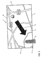
In
Das Navigationsgerät ist in einer Ausführungsform vorzugsweise so ausgestaltet, dass die Ausschnittsvergrößerung proportional zu dem Abstand des Fingers von der Oberfläche der Anzeigevorrichtung ist. Dies bedeutet, dass ein großer Bereich in einem kleinen Maßstab auf der Anzeigevorrichtung angezeigt wird, wenn der Finger sich in einem großen Abstand befindet und ein kleiner Bereich vergrößert (hineingezoomt) dargestellt wird, wenn sich der Finger in einem kleinen Abstand vor der Anzeigevorrichtung befindet.In one embodiment, the navigation device is preferably designed so that the enlargement of the detail is proportional to the distance of the finger from the surface of the display device. This means that a large area is displayed on a small scale on the display device when the finger is at a large distance and a small area is enlarged (zoomed in) is displayed when the finger is in a small distance in front of the display device.
Um den dargestellten Bereich bei gleich bleibender Vergrößerung, d. h. in der Kartenebene verändern zu können, ist vorteilhafterweise vorgesehen, dass der Bereich verschoben wird, wenn der Finger von einer Zentralachse entfernt wird. Die Zentralachse fällt vorzugsweise mit einer Blickachse von dem Nutzer auf eine Mitte der Anzeigevorrichtung zusammen. Dieses bedeutet, dass der Finger aus Sicht des Nutzers an den Rand oder sogar über diesen hinaus bewegt wird, um den Kartenausschnitt "zu verschieben". Dieses ist in
Die Verschiebung in der Kartenebene und das Wählen der Vergrößerung kann zeitgleich erfolgen, so dass das Zoomen und Verschieben in Abhängigkeit von der räumlichen Position des Fingers erfolgt.The shift in the map plane and the selection of the magnification can occur at the same time, so that the zooming and shifting takes place depending on the spatial position of the finger.
Befindet sich der Finger auf einer Zentralachse oder in einem Volumenbereich um die Zentralachse, so findet keine Verschiebung des Kartenausschnitts statt. Dieses Volumen kann zylinderförmig gewählt werden oder ein Volumen sein, das sich aus einer Projektion einer Anzeigefläche der Anzeigevorrichtung entlang der Zentralachse ergibt. Andere Formen können für das Volumen gewählt werden. Die Zentralachse steht in einer Ausführungsform senkrecht auf einem Mittelpunkt einer Anzeigefläche der Anzeigevorrichtung. Die Wahl einer Zentralachse, die von dieser Orientierung abweicht, bietet die Möglichkeit, die Bedienung angepasst an eine Blickrichtung des Fahrzeugführers auszuführen. Die Zentralachse wird beispielsweise deckungsgleich zu einer Blickrichtung des Fahrzeuglenkers auf die Mitte des Anzeigefelds der Anzeigevorrichtung gewählt. Alternativ kann eine Festlegung der Zentralachse mittels eines Kalibrierungsverfahrens erfolgen, in dem der Nutzer aufgefordert wird, das zur Betätigung verwendete Körperteil zur Mitte der Anzeigefläche zu führen. Die Kurve, der das Körperteil folgt, kann erfasst und als Zentralachse verwendet werden. Dieses bedeutet, dass die Zentralachse nicht zwangsläufig durch eine Gerade approximierbar sein muss, sondern auch eine gekrümmte stetige Kurve sein kann.If the finger is located on a central axis or in a volume area around the central axis, no displacement of the map section takes place. This volume can be chosen to be cylindrical or a volume resulting from a projection of a display area of the display device along the central axis. Other shapes can be chosen for the volume. The central axis in one embodiment is perpendicular to a center of a display area of the display device. The choice of a central axis, which deviates from this orientation, offers the possibility to perform the operation adapted to a line of sight of the driver. The central axis is chosen, for example, congruent to a viewing direction of the vehicle driver on the center of the display panel of the display device. Alternatively, a determination of the central axis can be made by means of a calibration method in which the user is requested to guide the body part used for actuation to the center of the display area. The curve following the body part can be detected and used as the central axis. This means that the central axis does not necessarily have to be approximated by a straight line, but can also be a curved continuous curve.
Der oder die Sensoren sind vorzugsweise so ausgestaltet, dass eine räumliche Ausdehnung des Körperteils erfasst werden kann. Hierdurch wird die Möglichkeit geschaffen, Gesten interpretieren zu können. Um den Finger bzw. die Hand, an der der Finger angewachsen ist, nach einer Bedienaktion entfernen zu können, ohne hierdurch eine Verschiebung des Kartenausschnitts oder eine Veränderung der Größendarstellung (des Zooms) zu bewirken, ist vorgesehen, dass eine Geste mit der Hand ausgeführt wird, die als Bedienstoppsignal erkannt wird. Werden beispielsweise die übrigen Finger der Hand ausgeklappt, so dass sich eine flache Hand ergibt, deren Fläche im Wesentlichen senkrecht zur Zentralachse ausgerichtet ist, wird dieses als Bedienstoppsignal erkannt. Die Hand kann jetzt vor der Anzeigevorrichtung des Navigationsgeräts entfernt werden, ohne dass dieses einen Einfluss auf die Darstellung hat.The sensor or sensors are preferably designed such that a spatial extent of the body part can be detected. This creates the opportunity to interpret gestures. In order to be able to remove the finger or the hand, on which the finger has grown, after an operating action, without thereby causing a shift of the map section or a change in the size representation (of the zoom), it is provided that a gesture is carried out by hand which is recognized as an operating stop signal. If, for example, the remaining fingers of the hand are unfolded, resulting in a flat hand, the surface of which is oriented essentially perpendicular to the central axis, this is recognized as an operating stop signal. The hand can now be removed in front of the display device of the navigation device, without this having an influence on the presentation.
Das Zoomen und Verschieben des Kartenausschnitts kann auch auf andere Weise vorteilhaft erreicht werden. Hierzu wird der Raum oder das Volumen vor und gegebenenfalls auch neben der Anzeigevorrichtung in Teilvolumina, die auch als dreidimensionale Abschnitte, Schichten oder Gebiete oder Sektoren, vorzugsweise quaderförmige oder Zylinder-/ oder Kegelsektorabschnitte, unterteilt. Den Teilvolumina werden Aktionen zugewiesen. Befindet sich eine Fingerspitze in einem Teilvolumen oder Abschnitt, so wird die entsprechende Aktion ausgeführt. Die Teilvolumina oder Abschnitte können sich im Raum überlappen, um eine hystereseartige Bedienung zu erreichen. Dieses bewirkt, dass eine Fingerspitze, die aus einem Abschnitt in einen anderen Abschnitt bewegt ist, erst deutlich wieder aus diesem anderen Abschnitt heraus in den einen Abschnitt bewegt werden muss, um wieder als in dem einen Abschnitt befindlich betrachtet zu werden. Ein kontinuierlicher ungewollter Wechsel zwischen zwei Aktionen wird hierdurch vermieden.The zooming and shifting of the map section can also be advantageously achieved in other ways. For this purpose, the space or the volume before and optionally also in addition to the display device in sub-volumes, which are also as three-dimensional sections, layers or areas or sectors, preferably cuboid or cylindrical / or cone sector sections divided. The partial volumes are assigned actions. If a fingertip is in a subvolume or section, the corresponding action will be performed. The sub-volumes or sections may overlap in space to achieve hysteresis-like operation. This causes a fingertip, which has moved from one section to another section, to be clearly moved back out of that other section into the one section only to be considered to be in the one section again. A continuous unwanted change between two actions is thereby avoided.
Eine einfache Ausführungsform nach
Befindet sich der Finger in einer der Zonen 12-16, so wird die zughörige Aktion ausgeführt. Das Zoomen findet beispielsweise so lange statt, wie sich der Finger in den entsprechenden Zonen 14 oder 16 befindet. Es ist vorgesehen, dass die den Zonen 12-16 zugeordnete Aktion erst bei einer gewissen vorgegebenen Verweildauer des Fingers in der Zone 12-16 ausgeführt wird. Zusätzlich kann vorgesehen sein, dass die zugeordnete Funktion/Aktion einer Zone 12-16 davon abhängig ist, aus welcher Zone 12-16 der Finger in die jeweilige Zone 12-16 bewegt wird oder mit welcher Geschwindigkeit er sich in die Zone bewegt. So kann vorgesehen sein, dass, wenn der Finger von außerhalb der Zonen 12-16 (aus großer Entfernung) in die äußerste Zone 16 bewegt wird, ein Verkleinern (zoom out) der Darstellung nicht erfolgt. Dieses erfolgt nur, wenn zuvor ein Vergrößern der Darstellung in demselben Bedienzusammenhang stattgefunden hat.If the finger is in one of the zones 12-16, the associated action is executed. For example, the zooming takes place as long as the finger is in the corresponding
Am bevorzugtesten ist eine Kombination, die sowohl die Eintrittsrichtung als auch eine Verweildauer und/oder eine Eintrittsgeschwindigkeit berücksichtigt. So kann erreicht werden, dass nach dem Vergrößern der Darstellung diese erhalten bleibt, wenn der Finger schnell durch die äußerste Zone 16 bewegt wird, ohne ein Herauszoomen zu bewirken. Alternativ oder zusätzlich kann auch bei dieser Ausführungsform eine Interpretation von Gesten durchgeführt werden.Most preferred is a combination that takes into account both the direction of entry and a dwell time and / or an entry speed. Thus, it can be achieved that, after enlarging the representation, it is maintained when the finger is moved rapidly through the
Der innersten Zone 12 ist keine Aktion (oder die Aktion "lasse die Darstellung unverändert") zugewiesen, um zu ermöglichen, dass bei einer als Touchscreen ausgebildeten Anzeigevorrichtung 11 eine Bedienhandlung durchgeführt werden kann, ohne dass sich die Darstellung des Kartenausschnitts verändert. Hierdurch ist es möglich, jeden Punkt auf dem dargestellten Kartenausschnitt anzuwählen.The
Eine Zentralachse 17 steht bei dieser Ausführungsform senkrecht auf einer Oberfläche der Anzeigevorrichtung.A
Die Aufteilung des Volumens in Teilvolumina, in Bereiche und Zonen und Sektoren, kann den jeweiligen Erfordernissen angepasst werden. Es können mehr oder weniger als fünf Zonen verwendet werden. Die Zonen können in beliebig viele Unterzonen oder Sektoren unterteilt sein. Innerhalb einer Zone kann die Position auch zur variablen Veränderung herangezogen werden. D. h. in einer Zone bzw. einem Abschnitt kann die Position des Fingers innerhalb der Zone die Zoomgeschwindigkeit (Vergrößerung pro Zeiteinheit) beeinflussen oder festlegen. Die Position innerhalb der Zone kann aber auch die Vergrößerungsstufe angeben.The division of the volume into sub-volumes, into areas and zones and sectors, can be adapted to the respective requirements. More or less than five zones can be used. The zones can be divided into any number of subzones or sectors. Within a zone, the position can also be used for the variable change. Ie. in a zone or section, the position of the finger within the zone may affect or set the zoom speed (magnification per unit of time). The position within the zone can also indicate the magnification level.
Eine Ausführungsform sieht vor, dass ein Auswählen von Bedienelementen, die in die Kartendarstellung integriert sind, erfolgt, wenn der Finger eine vorgegebene Betätigungszeitspanne über dem Bedienelement verweilt. In
Wird der Finger über einen Punkt von Interesse bewegt, so werden vorzugsweise Informationen 21, die mit diesem verknüpft sind, vergrößert dargestellt. Dieses ist in
In
Es können Ausführungsformen gebildet werden, die einzelne der beschriebenen Merkmale oder unterschiedliche Kombinationen der Merkmale umfassen.Embodiments may be formed that include individual ones of the described features or different combinations of the features.
Im Folgenden wird eine Ausführungsform eines Navigationsgeräts beschrieben, das schematisch in
Ein Navigationsgerät 30 umfasst einen Kartenspeicher 31, eine Vorrichtung 32 zum Ermitteln der Position des Fahrzeugs, vorzugsweise einen Sattelitennavigationsempfänger, eine Steuereinheit 33, eine Anzeigevorrichtung 34 sowie eine Vorrichtung 35 zum Erfassen von Nutzereingaben. Das Navigationsgerät 30 ist in eine Multifunktionsbedienvorrichtung 36 integriert. Die Vorrichtung 35 zum Erfassen von Nutzereingaben umfasst eine oder mehrere Sensoreinheiten 37, die eine Position eines Körperteils, beispielsweise eines Fingers, eines Nutzers vor der Anzeigevorrichtung 34 ermitteln kann oder können. Vorzugsweise umfasst die Vorrichtung 35 mindestens vier an den Ecken der Anzeigevorrichtung angeordnete Sensoreinheiten 37, die über den Körper des Nutzers übertragene Hochfrequenzsignale erfassen können. Solche Sensoreinheiten 37 können so ausgestaltet werden, dass sie bereits eine Annäherung des Körperteils detektieren. Diese Sensoreinheiten 37 basieren auf Detektionssystemen, wie sie beispielhaft in der Druckschrift
Alternativ können auf Kameras basierende, ultraschallbasierte oder auf optischen Sensoren basierende Sensoreinheiten verwendet werden.Alternatively, camera-based, ultrasound-based, or optical sensor-based sensor units may be used.
Eine solche Sensoreinheit, die ein optisches Verfahren verwendet, kann beispielsweise gemäß folgendem Prinzip ausgestaltet sein. Eine Sende-LED strahlt ein rechteckförmig amplitudenmoduliertes Lichtsignal im optischen oder infraroten Wellenlängenbereich ab. Das an einem Objekt, beispielsweise dem Körperteil, reflektierte Lichtsignal wird von einer Photodiode erfasst. Von einer Kompensations-LED wird ein um 180° phasenversetztes ebenfalls rechteckförmig amplitudenmoduliertes Referenzlichtsignal zu der Photodiode über einen unveränderlichen Lichtweg gesandt. Die Kompensations-LED wird über einen Regelkreis mittels eines Regelsignals so ausgeregelt, dass sich das empfangene reflektierte Lichtsignal der Sende-LED und das empfangene Referenzlichtsignal der Kompensations-LED an der Photodiode aufheben und ein Gleichsignal detektiert wird. Eine Änderung des Regelsignals ist ein Maß für den Abstand des Objekts. Eine nach diesem Prinzip ausgestaltete Sensoreinheit ist weitgehend unabhängig von Temperatur- und Helligkeitsschwankungen.Such a sensor unit using an optical method may be configured, for example, according to the following principle. A transmission LED emits a rectangular amplitude modulated light signal in the optical or infrared wavelength range. The light signal reflected on an object, for example the body part, is detected by a photodiode. From a compensation LED, a 180 ° out of phase, also rectangular amplitude modulated reference light signal is sent to the photodiode via a fixed light path. The compensation LED is adjusted via a control loop by means of a control signal so that cancel the received reflected light signal of the transmit LED and the received reference light signal of the compensation LED on the photodiode and a DC signal is detected. A change of the Control signal is a measure of the distance of the object. A configured according to this principle sensor unit is largely independent of temperature and brightness variations.
Zusätzlich zu den Sensoreinheiten 37, die die Position eines Körperteils erfassen, kann das Navigationsgerät beliebige weitere Bedienelemente 38 umfassen.In addition to the
Auf der Anzeigevorrichtung 34 wird im Betrieb in der Regel ein Kartenausschnitt dargestellt, dessen Mittelpunkt mit einer aktuellen Position des Fahrzeugs zusammentrifft. Um beispielsweise eine Zielposition zu erfassen, wird von der oder den Sensoreinheiten 37 eine Position eines Fingers des Nutzers erfasst. In Abhängigkeit von der Position wird, wie oben beschrieben, die Darstellung des Kartenausschnitts mittels der Steuereinheit 33, die eine häufig in Software ausgeführte Anpassungseinheit 39 umfasst, auf Basis der in dem Kartenspeicher 31 abgelegten Navigationsinformationen angepasst. Ist die Auflösung der Darstellung ausreichend um die Zielposition genau eingeben zu können, berührt der Nutzer die Anzeigevorrichtung 34, die als Touchscreen-Vorrichtung ausgebildet ist. Um eine Anpassung der Kartendarstellung hierbei unverändert zu lassen, spreizt der Nutzer zuvor beispielsweise seine Finger auseinander. Die Sensoreinheiten 37 erfassen eine größere flächige Ausdehnung des Körperteils, da ein minimaler Abstand zu den unterschiedlichen Sensoreinheiten 37 jeweils verringert ist. Hieraus erkennt die Steuereinheit 33 eine Bedienstoppgeste und lässt die Kartendarstellung beispielsweise für eine vorgegebene Zeitspanne unverändert. Ein Zeichnen eines Kreises mit einem Finger kann ebenfalls eine mögliche Bedienstoppgeste darstellen. Während die erste Geste statisch ist, ist die zweite vorgeschlagene Bedienstoppgeste dynamisch und hängt von der Ermittlung der Position des Körperteils zu aufeinander folgenden Zeitpunkten und gegebenenfalls zusätzlich von einer Geschwindigkeit ab, mit der die einzelnen Positionen auf dem Kreis von dem Körperteil durchlaufen werden. Die Steuereinheit 33 erfasst die Position auf der Anzeigevorrichtung 34 und errechnet die zugehörige Kartenposition. Diese wird als Zielposition für eine zielgeführte kartenbasierte Navigation verwendet, wie es im Stand der Technik bekannt ist.In operation, a map section is usually displayed on the
Die Anzeigevorrichtung kann als Projektionsanzeige ausgebildet sein, bei der die dargestellten Informationen auf eine Fläche projiziert werden. In einem solchen Fall ist der Abstand bzw. die Bewegung des Körperteils usw. relativ zu dieser Fläche relevant.The display device can be designed as a projection display, in which the displayed information is projected onto a surface. In such a case, the distance or movement of the body part, etc. relative to this surface is relevant.
Claims (23)
- Navigation device (30) in a vehicle for providing assistance with orientation and finding a desired route, having a display apparatus (34) in the form of a touchscreen and at least one sensor unit (37) for determining a position of a body part, in particular a finger of a user, at least relative to a display area of the display apparatus (34) as early as when approaching the display apparatus (34),
navigation information, in particular map sections, being presented on the display area in an adapted manner on the basis of the determined position of the body part,
a volume in front of the display area being divided into partial volumes, and the at least one sensor unit (37) being configured in such a manner that the determination of the position involves determining one of the partial volumes in which the body part is situated, and the presentation of the navigation information being adapted on the basis of the determined partial volume in which the body part is situated,
characterized in that
adaptation according to the actions assigned to the respectively determined partial volumes does not take place for a predefined period of time after an operation stop gesture carried out by the body part has been detected using the at least one sensor unit (37). - Navigation device (30) according to Claim 1, characterized in that the at least one sensor unit is designed to detect an increase in a two-dimensional extent of the body part as the operation stop gesture.
- Navigation device (30) according to Claim 1 or 2, characterized in that the at least one sensor unit is designed to detect a movement carried out by the body part as the operation stop gesture.
- Navigation device (30) according to one of the preceding claims, characterized in that the at least one sensor unit (37) is configured in such a manner that the determination of the position involves determining a distance between the body part and the display area, and the presentation of the navigation information with respect to a section enlargement of the navigation information, in particular a section size of the map section, is adapted on the basis of the determined distance.
- Navigation device (30) according to Claim 4, characterized in that the presentation of the navigation information with respect to the section enlargement of the navigation information is proportionally dependent on the determined distance between the body part and the display area.
- Navigation device (30) according to one of the preceding claims, characterized in that the at least one sensor unit (37) is configured in such a manner that the determination of the position involves determining a lateral distance between the body part and a central axis on the display area, and the presentation of the navigation information with respect to a section selection of the navigation information, in particular a section area selection of the map section, is adapted on the basis of the determined lateral distance.
- Navigation device (30) according to one of the preceding claims, characterized in that the presentation is adapted continuously and/or in stages on the basis of the distance and/or the lateral distance.
- Navigation device (30) according to one of the preceding claims, characterized in that at least one partial volume is distinguished, inside which a movement of the body part is possible without causing adaptation of the presentation of the navigation information.
- Navigation device (30) according to one of the preceding claims, characterized in that the partial volumes partially overlap one another.
- Navigation device (30) according to one of the preceding claims, characterized in that the sensor unit (37) is configured to determine at least one further position in advance in terms of time, and the presentation is adapted on the basis of the at least one further position and the position.
- Navigation device (30) according to one of the preceding claims, characterized by a speed determination unit for determining a speed of the body part, the presentation of the navigation information additionally being adapted on the basis of the determined speed.
- Method for operating a navigation device (30) in a vehicle in order to provide a driver with assistance with orientation and finding a desired route, involving determination of a position of a body part, in particular a finger of a user, at least relative to a display area of a display apparatus (34) in the form of a touchscreen using at least one sensor unit (37) as early as when approaching the display area (34) and adaptation of a presentation of navigation information on the basis of the determined position of the body part, a volume in front of the display area being divided into partial volumes and the determination of the position involving determining one of the partial volumes in which the body part is situated, and the presentation of the navigation information being adapted on the basis of the determined partial volume in which the body part is situated,
characterized in that
an operation stop gesture carried out by the body part is detected using the at least one sensor unit, and adaptation according to the actions assigned to the respectively determined partial volumes does not take place for a predefined period of time after the operation stop gesture has been detected. - Method according to Claim 12, characterized in that an increase in a two-dimensional extent of the body part is detected as the operation stop gesture.
- Method according to Claim 12 or 13, characterized in that a movement carried out by the body part is detected as the operation stop gesture.
- Method according to one of Claims 12 to 14, characterized in that the determination of the position involves determining a distance between the body part and the display area, and the presentation of the navigation information with respect to a section enlargement of the navigation information, in particular a section size of the map section, is adapted on the basis of the determined distance.
- Method according to Claim 15, characterized in that navigation information with respect to the section enlargement of the navigation information is presented in an adapted manner in proportion to the determined distance between the body part and the display area.
- Method according to one of Claims 12 to 16, characterized in that the determination of the position involves determining a lateral distance between the body part and a central axis on the display area, and the presentation of the navigation information with respect to a section selection of the navigation information, in particular a section area selection of the map section, is adapted on the basis of the determined lateral distance.
- Method according to one of Claims 12 to 17, characterized in that the presentation is adapted continuously and/or in stages on the basis of the distance and/or the lateral distance.
- Method according to one of Claims 12 to 18, characterized in that at least one partial volume is distinguished, inside which a movement of the body part is possible without causing adaptation of the presentation of the navigation information.
- Method according to one of Claims 12 to 19, characterized in that at least one further position is determined prior to the position in terms of time, and the presentation is adapted on the basis of the at least one further position and the position.
- Method according to one of Claims 12 to 20, characterized in that the partial volumes partially overlap one another, and the adaptation functions assigned to the partial volumes are changed in a hysteresis-like manner, with the result that the determined position of the body part is considered to be in one of the partial volumes if the determined position is not simultaneously still in the adjacent partial volume in which the body part was previously situated.
- Method according to one of Claims 12 to 21, characterized in that a speed of the body part is determined, and the presentation of the navigation information is additionally adapted on the basis of the determined speed.
- Method according to Claim 22, characterized in that the presentation is not adapted if the body part is moved at a speed above a predefined threshold speed.
Applications Claiming Priority (2)
| Application Number | Priority Date | Filing Date | Title |
|---|---|---|---|
| DE102006014473 | 2006-03-27 | ||
| DE102006037154A DE102006037154A1 (en) | 2006-03-27 | 2006-08-02 | Navigation device and method for operating a navigation device |
Publications (2)
| Publication Number | Publication Date |
|---|---|
| EP1840522A1 EP1840522A1 (en) | 2007-10-03 |
| EP1840522B1 true EP1840522B1 (en) | 2013-10-23 |
Family
ID=38191186
Family Applications (1)
| Application Number | Title | Priority Date | Filing Date |
|---|---|---|---|
| EP20070005904 Active EP1840522B1 (en) | 2006-03-27 | 2007-03-22 | Navigation device and method for operating a navigation device |
Country Status (2)
| Country | Link |
|---|---|
| EP (1) | EP1840522B1 (en) |
| DE (1) | DE102006037154A1 (en) |
Families Citing this family (23)
| Publication number | Priority date | Publication date | Assignee | Title |
|---|---|---|---|---|
| DE102008013742A1 (en) * | 2008-03-12 | 2009-09-24 | Daimler Ag | Device and method for route planning and route guidance |
| US8443302B2 (en) * | 2008-07-01 | 2013-05-14 | Honeywell International Inc. | Systems and methods of touchless interaction |
| DE102008032377A1 (en) | 2008-07-09 | 2010-01-14 | Volkswagen Ag | Method for operating a control system for a vehicle and operating system for a vehicle |
| DE102008042734A1 (en) * | 2008-10-10 | 2010-04-15 | Robert Bosch Gmbh | Driver information system for a motor vehicle |
| DE102008053547B4 (en) | 2008-10-28 | 2018-03-01 | Volkswagen Ag | Method and device for displaying information on a display surface in a vehicle |
| JP5182202B2 (en) | 2009-04-14 | 2013-04-17 | ソニー株式会社 | Information processing apparatus, information processing method, and information processing program |
| DE102009030791A1 (en) | 2009-06-27 | 2010-12-30 | Volkswagen Ag | Navigation system, in particular for a motor vehicle |
| DE102009036369A1 (en) | 2009-08-06 | 2011-02-10 | Volkswagen Ag | Method for operating an operating device and operating device in a vehicle |
| EP2614417B1 (en) * | 2010-09-06 | 2017-08-02 | Valeo Schalter und Sensoren GmbH | Method for operating a driver assistance device, driver assistance device and vehicle with a driver assistance device |
| DE102010053788A1 (en) | 2010-12-08 | 2012-06-14 | Volkswagen Ag | Method for operation of operating device in vehicle, involves detecting approximation of actuating element at operating element or touch of operating element by actuating element |
| DE102012000274A1 (en) * | 2012-01-10 | 2013-07-11 | Daimler Ag | A method and apparatus for operating functions in a vehicle using gestures executed in three-dimensional space and related computer program product |
| DE102012011177A1 (en) * | 2012-06-06 | 2013-12-24 | GM Global Technology Operations LLC (n. d. Ges. d. Staates Delaware) | Method for operating functions of a vehicle and corresponding device |
| DE102013007329A1 (en) | 2013-01-04 | 2014-07-10 | Volkswagen Aktiengesellschaft | Method for operating an operating device in a vehicle |
| DE102013204242B4 (en) | 2013-03-12 | 2023-11-23 | Bayerische Motoren Werke Aktiengesellschaft | Display and operating device for a motor vehicle, motor vehicle and corresponding method |
| DE102013011531B4 (en) * | 2013-07-10 | 2018-04-26 | Audi Ag | Method for operating an assistance system of a motor vehicle and assistance system for a motor vehicle |
| DE102014206036A1 (en) * | 2014-03-31 | 2015-10-01 | Volkswagen Aktiengesellschaft | Operating method and operating system in a vehicle |
| DE102014207637A1 (en) * | 2014-04-23 | 2015-10-29 | Bayerische Motoren Werke Aktiengesellschaft | Gesture interaction with a driver information system of a vehicle |
| DE102014017179B4 (en) * | 2014-11-20 | 2022-10-06 | Audi Ag | Method for operating a navigation system of a motor vehicle using an operating gesture |
| DE102016212682A1 (en) * | 2016-07-12 | 2018-01-18 | Audi Ag | Gesture control by means of a transit time measurement camera system |
| DE102017216527A1 (en) | 2017-09-19 | 2019-03-21 | Bayerische Motoren Werke Aktiengesellschaft | Method for displaying information points on a digital map |
| DE102018007988A1 (en) | 2018-10-09 | 2019-04-11 | Daimler Ag | Method for operating a navigation system |
| DE102019207682A1 (en) * | 2019-05-24 | 2020-11-26 | Volkswagen Aktiengesellschaft | Method for the graphic configuration of a display instrument in a motor vehicle and motor vehicle for carrying out the method |
| CN110308835B (en) * | 2019-06-05 | 2022-10-14 | 创新先进技术有限公司 | Method and device for controlling view control and electronic equipment |
Family Cites Families (4)
| Publication number | Priority date | Publication date | Assignee | Title |
|---|---|---|---|---|
| JP3753753B2 (en) | 1995-01-20 | 2006-03-08 | 三菱電機株式会社 | Mobile information map information display device |
| US8479122B2 (en) | 2004-07-30 | 2013-07-02 | Apple Inc. | Gestures for touch sensitive input devices |
| DE50014953D1 (en) | 2000-08-24 | 2008-03-20 | Siemens Vdo Automotive Ag | Method and navigation device for querying destination information and navigating in a map view |
| US7665041B2 (en) * | 2003-03-25 | 2010-02-16 | Microsoft Corporation | Architecture for controlling a computer using hand gestures |
-
2006
- 2006-08-02 DE DE102006037154A patent/DE102006037154A1/en not_active Withdrawn
-
2007
- 2007-03-22 EP EP20070005904 patent/EP1840522B1/en active Active
Also Published As
| Publication number | Publication date |
|---|---|
| EP1840522A1 (en) | 2007-10-03 |
| DE102006037154A1 (en) | 2007-10-18 |
Similar Documents
| Publication | Publication Date | Title |
|---|---|---|
| EP1840522B1 (en) | Navigation device and method for operating a navigation device | |
| EP1998996B1 (en) | Interactive operating device and method for operating the interactive operating device | |
| EP2424743B1 (en) | Method for displaying and inputting information in a motor vehicle, and display device | |
| EP2338106B1 (en) | Multi-function display and operating system and method for controlling such a system having optimized graphical operating display | |
| EP2179346B1 (en) | Display device and operator panel for a motor vehicle, comprising a multi-view display device | |
| EP3009799A1 (en) | Method for operating a motor vehicle employing a touch screen | |
| EP2883738B1 (en) | Method and assembly for controlling functions of a motor vehicle | |
| EP1930696A2 (en) | Method and device for controlling the display of information in two areas on a display screen in a means of transport | |
| EP2943367A1 (en) | Method for synchronizing display devices in a motor vehicle | |
| EP2283320B1 (en) | Display method for a display system, display system and operating method for a navigation system in a vehicle | |
| WO2013034294A1 (en) | Control device for a motor vehicle and method for operating the control device for a motor vehicle | |
| DE102015203774A1 (en) | manipulation device | |
| WO2014108147A1 (en) | Zooming and shifting of image content of a display device | |
| EP2050610B1 (en) | Motor vehicle | |
| WO2014108152A2 (en) | Motor vehicle user interface comprising a control element for detecting a control action | |
| EP2718672B1 (en) | Method and apparatus for providing a user interface | |
| DE102014207637A1 (en) | Gesture interaction with a driver information system of a vehicle | |
| EP3394570B1 (en) | Display system and method of operating a display system in a vehicle with at least a first and a second display surface | |
| DE102020207040B3 (en) | Method and device for the manual use of an operating element and a corresponding motor vehicle | |
| WO2015010829A1 (en) | Method for operating an input device, and input device | |
| DE102013211046A1 (en) | Method and device for obtaining a control signal from an operating gesture | |
| DE102017216527A1 (en) | Method for displaying information points on a digital map | |
| DE102012021252A1 (en) | Operating device for actuating e.g. DVD player mounted in motor car, has sensors that detect coordinates of operating unit in spatial directions, and evaluation device that determines position of operating unit based on coordinates | |
| WO2016096321A1 (en) | Method for controlling a vehicle system | |
| EP2224213A2 (en) | Navigation device and method with context-sensitive direct selection of information objects |
Legal Events
| Date | Code | Title | Description |
|---|---|---|---|
| PUAI | Public reference made under article 153(3) epc to a published international application that has entered the european phase |
Free format text: ORIGINAL CODE: 0009012 |
|
| AK | Designated contracting states |
Kind code of ref document: A1 Designated state(s): AT BE BG CH CY CZ DE DK EE ES FI FR GB GR HU IE IS IT LI LT LU LV MC MT NL PL PT RO SE SI SK TR |
|
| AX | Request for extension of the european patent |
Extension state: AL BA HR MK YU |
|
| RIN1 | Information on inventor provided before grant (corrected) |
Inventor name: DEHMANN, RAINER Inventor name: WAGNER, VOLKMAR Inventor name: BACHFISCHER, KATHARINA Inventor name: WAELLER, CHRISTOPH |
|
| 17P | Request for examination filed |
Effective date: 20080403 |
|
| AKX | Designation fees paid |
Designated state(s): AT BE BG CH CY CZ DE DK EE ES FI FR GB GR HU IE IS IT LI LT LU LV MC MT NL PL PT RO SE SI SK TR |
|
| 17Q | First examination report despatched |
Effective date: 20080520 |
|
| RAP1 | Party data changed (applicant data changed or rights of an application transferred) |
Owner name: VOLKSWAGEN AKTIENGESELLSCHAFT |
|
| GRAJ | Information related to disapproval of communication of intention to grant by the applicant or resumption of examination proceedings by the epo deleted |
Free format text: ORIGINAL CODE: EPIDOSDIGR1 |
|
| GRAP | Despatch of communication of intention to grant a patent |
Free format text: ORIGINAL CODE: EPIDOSNIGR1 |
|
| GRAP | Despatch of communication of intention to grant a patent |
Free format text: ORIGINAL CODE: EPIDOSNIGR1 |
|
| RIC1 | Information provided on ipc code assigned before grant |
Ipc: G06F 3/0481 20130101ALI20130522BHEP Ipc: G06F 3/01 20060101ALI20130522BHEP Ipc: G01C 21/36 20060101AFI20130522BHEP |
|
| INTG | Intention to grant announced |
Effective date: 20130618 |
|
| GRAS | Grant fee paid |
Free format text: ORIGINAL CODE: EPIDOSNIGR3 |
|
| GRAA | (expected) grant |
Free format text: ORIGINAL CODE: 0009210 |
|
| AK | Designated contracting states |
Kind code of ref document: B1 Designated state(s): AT BE BG CH CY CZ DE DK EE ES FI FR GB GR HU IE IS IT LI LT LU LV MC MT NL PL PT RO SE SI SK TR |
|
| REG | Reference to a national code |
Ref country code: GB Ref legal event code: FG4D Free format text: NOT ENGLISH |
|
| REG | Reference to a national code |
Ref country code: CH Ref legal event code: EP |
|
| REG | Reference to a national code |
Ref country code: AT Ref legal event code: REF Ref document number: 637839 Country of ref document: AT Kind code of ref document: T Effective date: 20131115 |
|
| REG | Reference to a national code |
Ref country code: IE Ref legal event code: FG4D Free format text: LANGUAGE OF EP DOCUMENT: GERMAN |
|
| REG | Reference to a national code |
Ref country code: DE Ref legal event code: R096 Ref document number: 502007012404 Country of ref document: DE Effective date: 20131219 |
|
| REG | Reference to a national code |
Ref country code: NL Ref legal event code: VDEP Effective date: 20131023 |
|
| REG | Reference to a national code |
Ref country code: LT Ref legal event code: MG4D |
|
| PG25 | Lapsed in a contracting state [announced via postgrant information from national office to epo] |
Ref country code: IS Free format text: LAPSE BECAUSE OF FAILURE TO SUBMIT A TRANSLATION OF THE DESCRIPTION OR TO PAY THE FEE WITHIN THE PRESCRIBED TIME-LIMIT Effective date: 20140223 Ref country code: FI Free format text: LAPSE BECAUSE OF FAILURE TO SUBMIT A TRANSLATION OF THE DESCRIPTION OR TO PAY THE FEE WITHIN THE PRESCRIBED TIME-LIMIT Effective date: 20131023 Ref country code: LT Free format text: LAPSE BECAUSE OF FAILURE TO SUBMIT A TRANSLATION OF THE DESCRIPTION OR TO PAY THE FEE WITHIN THE PRESCRIBED TIME-LIMIT Effective date: 20131023 Ref country code: NL Free format text: LAPSE BECAUSE OF FAILURE TO SUBMIT A TRANSLATION OF THE DESCRIPTION OR TO PAY THE FEE WITHIN THE PRESCRIBED TIME-LIMIT Effective date: 20131023 Ref country code: SE Free format text: LAPSE BECAUSE OF FAILURE TO SUBMIT A TRANSLATION OF THE DESCRIPTION OR TO PAY THE FEE WITHIN THE PRESCRIBED TIME-LIMIT Effective date: 20131023 |
|
| PG25 | Lapsed in a contracting state [announced via postgrant information from national office to epo] |
Ref country code: CY Free format text: LAPSE BECAUSE OF FAILURE TO SUBMIT A TRANSLATION OF THE DESCRIPTION OR TO PAY THE FEE WITHIN THE PRESCRIBED TIME-LIMIT Effective date: 20131023 Ref country code: LV Free format text: LAPSE BECAUSE OF FAILURE TO SUBMIT A TRANSLATION OF THE DESCRIPTION OR TO PAY THE FEE WITHIN THE PRESCRIBED TIME-LIMIT Effective date: 20131023 Ref country code: ES Free format text: LAPSE BECAUSE OF FAILURE TO SUBMIT A TRANSLATION OF THE DESCRIPTION OR TO PAY THE FEE WITHIN THE PRESCRIBED TIME-LIMIT Effective date: 20131023 |
|
| PG25 | Lapsed in a contracting state [announced via postgrant information from national office to epo] |
Ref country code: PT Free format text: LAPSE BECAUSE OF FAILURE TO SUBMIT A TRANSLATION OF THE DESCRIPTION OR TO PAY THE FEE WITHIN THE PRESCRIBED TIME-LIMIT Effective date: 20140224 |
|
| REG | Reference to a national code |
Ref country code: DE Ref legal event code: R082 Ref document number: 502007012404 Country of ref document: DE |
|
| REG | Reference to a national code |
Ref country code: DE Ref legal event code: R097 Ref document number: 502007012404 Country of ref document: DE |
|
| PG25 | Lapsed in a contracting state [announced via postgrant information from national office to epo] |
Ref country code: EE Free format text: LAPSE BECAUSE OF FAILURE TO SUBMIT A TRANSLATION OF THE DESCRIPTION OR TO PAY THE FEE WITHIN THE PRESCRIBED TIME-LIMIT Effective date: 20131023 |
|
| PG25 | Lapsed in a contracting state [announced via postgrant information from national office to epo] |
Ref country code: CZ Free format text: LAPSE BECAUSE OF FAILURE TO SUBMIT A TRANSLATION OF THE DESCRIPTION OR TO PAY THE FEE WITHIN THE PRESCRIBED TIME-LIMIT Effective date: 20131023 Ref country code: SK Free format text: LAPSE BECAUSE OF FAILURE TO SUBMIT A TRANSLATION OF THE DESCRIPTION OR TO PAY THE FEE WITHIN THE PRESCRIBED TIME-LIMIT Effective date: 20131023 Ref country code: IT Free format text: LAPSE BECAUSE OF FAILURE TO SUBMIT A TRANSLATION OF THE DESCRIPTION OR TO PAY THE FEE WITHIN THE PRESCRIBED TIME-LIMIT Effective date: 20131023 Ref country code: RO Free format text: LAPSE BECAUSE OF FAILURE TO SUBMIT A TRANSLATION OF THE DESCRIPTION OR TO PAY THE FEE WITHIN THE PRESCRIBED TIME-LIMIT Effective date: 20131023 Ref country code: PL Free format text: LAPSE BECAUSE OF FAILURE TO SUBMIT A TRANSLATION OF THE DESCRIPTION OR TO PAY THE FEE WITHIN THE PRESCRIBED TIME-LIMIT Effective date: 20131023 |
|
| PLBE | No opposition filed within time limit |
Free format text: ORIGINAL CODE: 0009261 |
|
| STAA | Information on the status of an ep patent application or granted ep patent |
Free format text: STATUS: NO OPPOSITION FILED WITHIN TIME LIMIT |
|
| PG25 | Lapsed in a contracting state [announced via postgrant information from national office to epo] |
Ref country code: DK Free format text: LAPSE BECAUSE OF FAILURE TO SUBMIT A TRANSLATION OF THE DESCRIPTION OR TO PAY THE FEE WITHIN THE PRESCRIBED TIME-LIMIT Effective date: 20131023 |
|
| 26N | No opposition filed |
Effective date: 20140724 |
|
| PG25 | Lapsed in a contracting state [announced via postgrant information from national office to epo] |
Ref country code: LU Free format text: LAPSE BECAUSE OF FAILURE TO SUBMIT A TRANSLATION OF THE DESCRIPTION OR TO PAY THE FEE WITHIN THE PRESCRIBED TIME-LIMIT Effective date: 20140322 |
|
| REG | Reference to a national code |
Ref country code: CH Ref legal event code: PL |
|
| REG | Reference to a national code |
Ref country code: DE Ref legal event code: R097 Ref document number: 502007012404 Country of ref document: DE Effective date: 20140724 |
|
| GBPC | Gb: european patent ceased through non-payment of renewal fee |
Effective date: 20140322 |
|
| REG | Reference to a national code |
Ref country code: IE Ref legal event code: MM4A |
|
| PG25 | Lapsed in a contracting state [announced via postgrant information from national office to epo] |
Ref country code: LI Free format text: LAPSE BECAUSE OF NON-PAYMENT OF DUE FEES Effective date: 20140331 Ref country code: GB Free format text: LAPSE BECAUSE OF NON-PAYMENT OF DUE FEES Effective date: 20140322 Ref country code: IE Free format text: LAPSE BECAUSE OF NON-PAYMENT OF DUE FEES Effective date: 20140322 Ref country code: CH Free format text: LAPSE BECAUSE OF NON-PAYMENT OF DUE FEES Effective date: 20140331 |
|
| PG25 | Lapsed in a contracting state [announced via postgrant information from national office to epo] |
Ref country code: SI Free format text: LAPSE BECAUSE OF FAILURE TO SUBMIT A TRANSLATION OF THE DESCRIPTION OR TO PAY THE FEE WITHIN THE PRESCRIBED TIME-LIMIT Effective date: 20131023 |
|
| REG | Reference to a national code |
Ref country code: AT Ref legal event code: MM01 Ref document number: 637839 Country of ref document: AT Kind code of ref document: T Effective date: 20140322 |
|
| PG25 | Lapsed in a contracting state [announced via postgrant information from national office to epo] |
Ref country code: AT Free format text: LAPSE BECAUSE OF NON-PAYMENT OF DUE FEES Effective date: 20140322 |
|
| PG25 | Lapsed in a contracting state [announced via postgrant information from national office to epo] |
Ref country code: MT Free format text: LAPSE BECAUSE OF FAILURE TO SUBMIT A TRANSLATION OF THE DESCRIPTION OR TO PAY THE FEE WITHIN THE PRESCRIBED TIME-LIMIT Effective date: 20131023 |
|
| REG | Reference to a national code |
Ref country code: FR Ref legal event code: PLFP Year of fee payment: 10 |
|
| PG25 | Lapsed in a contracting state [announced via postgrant information from national office to epo] |
Ref country code: BG Free format text: LAPSE BECAUSE OF FAILURE TO SUBMIT A TRANSLATION OF THE DESCRIPTION OR TO PAY THE FEE WITHIN THE PRESCRIBED TIME-LIMIT Effective date: 20131023 Ref country code: MC Free format text: LAPSE BECAUSE OF FAILURE TO SUBMIT A TRANSLATION OF THE DESCRIPTION OR TO PAY THE FEE WITHIN THE PRESCRIBED TIME-LIMIT Effective date: 20131023 |
|
| PG25 | Lapsed in a contracting state [announced via postgrant information from national office to epo] |
Ref country code: GR Free format text: LAPSE BECAUSE OF FAILURE TO SUBMIT A TRANSLATION OF THE DESCRIPTION OR TO PAY THE FEE WITHIN THE PRESCRIBED TIME-LIMIT Effective date: 20140124 |
|
| PG25 | Lapsed in a contracting state [announced via postgrant information from national office to epo] |
Ref country code: HU Free format text: LAPSE BECAUSE OF FAILURE TO SUBMIT A TRANSLATION OF THE DESCRIPTION OR TO PAY THE FEE WITHIN THE PRESCRIBED TIME-LIMIT; INVALID AB INITIO Effective date: 20070322 Ref country code: BE Free format text: LAPSE BECAUSE OF FAILURE TO SUBMIT A TRANSLATION OF THE DESCRIPTION OR TO PAY THE FEE WITHIN THE PRESCRIBED TIME-LIMIT Effective date: 20140331 Ref country code: TR Free format text: LAPSE BECAUSE OF FAILURE TO SUBMIT A TRANSLATION OF THE DESCRIPTION OR TO PAY THE FEE WITHIN THE PRESCRIBED TIME-LIMIT Effective date: 20131023 |
|
| REG | Reference to a national code |
Ref country code: FR Ref legal event code: PLFP Year of fee payment: 11 |
|
| REG | Reference to a national code |
Ref country code: FR Ref legal event code: PLFP Year of fee payment: 12 |
|
| PGFP | Annual fee paid to national office [announced via postgrant information from national office to epo] |
Ref country code: FR Payment date: 20230323 Year of fee payment: 17 |
|
| PGFP | Annual fee paid to national office [announced via postgrant information from national office to epo] |
Ref country code: DE Payment date: 20230331 Year of fee payment: 17 |
|
| P01 | Opt-out of the competence of the unified patent court (upc) registered |
Effective date: 20230523 |