EP1804025A2 - Route guidance system and route guidance method - Google Patents
Route guidance system and route guidance method Download PDFInfo
- Publication number
- EP1804025A2 EP1804025A2 EP06127242A EP06127242A EP1804025A2 EP 1804025 A2 EP1804025 A2 EP 1804025A2 EP 06127242 A EP06127242 A EP 06127242A EP 06127242 A EP06127242 A EP 06127242A EP 1804025 A2 EP1804025 A2 EP 1804025A2
- Authority
- EP
- European Patent Office
- Prior art keywords
- lane
- host vehicle
- driving
- processing portion
- recommended
- Prior art date
- Legal status (The legal status is an assumption and is not a legal conclusion. Google has not performed a legal analysis and makes no representation as to the accuracy of the status listed.)
- Granted
Links
- 238000000034 method Methods 0.000 title claims description 8
- 238000012545 processing Methods 0.000 claims abstract description 191
- 238000001514 detection method Methods 0.000 claims abstract description 11
- 238000010586 diagram Methods 0.000 description 29
- 238000013500 data storage Methods 0.000 description 19
- 230000005540 biological transmission Effects 0.000 description 11
- 238000004891 communication Methods 0.000 description 11
- 238000012544 monitoring process Methods 0.000 description 9
- 230000003287 optical effect Effects 0.000 description 8
- 230000015654 memory Effects 0.000 description 7
- 230000006870 function Effects 0.000 description 3
- 238000013459 approach Methods 0.000 description 2
- 238000012986 modification Methods 0.000 description 2
- 230000004048 modification Effects 0.000 description 2
- 230000002441 reversible effect Effects 0.000 description 2
- 230000002194 synthesizing effect Effects 0.000 description 2
- 206010039203 Road traffic accident Diseases 0.000 description 1
- 229910000831 Steel Inorganic materials 0.000 description 1
- 230000000994 depressogenic effect Effects 0.000 description 1
- 230000004069 differentiation Effects 0.000 description 1
- 230000000694 effects Effects 0.000 description 1
- 238000007670 refining Methods 0.000 description 1
- 230000001105 regulatory effect Effects 0.000 description 1
- 239000000523 sample Substances 0.000 description 1
- 239000010959 steel Substances 0.000 description 1
- 239000000126 substance Substances 0.000 description 1
- 230000003936 working memory Effects 0.000 description 1
Images


Classifications
-
- G—PHYSICS
- G01—MEASURING; TESTING
- G01C—MEASURING DISTANCES, LEVELS OR BEARINGS; SURVEYING; NAVIGATION; GYROSCOPIC INSTRUMENTS; PHOTOGRAMMETRY OR VIDEOGRAMMETRY
- G01C21/00—Navigation; Navigational instruments not provided for in groups G01C1/00 - G01C19/00
- G01C21/26—Navigation; Navigational instruments not provided for in groups G01C1/00 - G01C19/00 specially adapted for navigation in a road network
- G01C21/34—Route searching; Route guidance
- G01C21/36—Input/output arrangements for on-board computers
- G01C21/3602—Input other than that of destination using image analysis, e.g. detection of road signs, lanes, buildings, real preceding vehicles using a camera
-
- G—PHYSICS
- G01—MEASURING; TESTING
- G01C—MEASURING DISTANCES, LEVELS OR BEARINGS; SURVEYING; NAVIGATION; GYROSCOPIC INSTRUMENTS; PHOTOGRAMMETRY OR VIDEOGRAMMETRY
- G01C21/00—Navigation; Navigational instruments not provided for in groups G01C1/00 - G01C19/00
- G01C21/26—Navigation; Navigational instruments not provided for in groups G01C1/00 - G01C19/00 specially adapted for navigation in a road network
- G01C21/34—Route searching; Route guidance
- G01C21/36—Input/output arrangements for on-board computers
- G01C21/3626—Details of the output of route guidance instructions
- G01C21/3655—Timing of guidance instructions
-
- G—PHYSICS
- G01—MEASURING; TESTING
- G01C—MEASURING DISTANCES, LEVELS OR BEARINGS; SURVEYING; NAVIGATION; GYROSCOPIC INSTRUMENTS; PHOTOGRAMMETRY OR VIDEOGRAMMETRY
- G01C21/00—Navigation; Navigational instruments not provided for in groups G01C1/00 - G01C19/00
- G01C21/26—Navigation; Navigational instruments not provided for in groups G01C1/00 - G01C19/00 specially adapted for navigation in a road network
- G01C21/34—Route searching; Route guidance
- G01C21/36—Input/output arrangements for on-board computers
- G01C21/3626—Details of the output of route guidance instructions
- G01C21/3658—Lane guidance
-
- G—PHYSICS
- G08—SIGNALLING
- G08G—TRAFFIC CONTROL SYSTEMS
- G08G1/00—Traffic control systems for road vehicles
- G08G1/09—Arrangements for giving variable traffic instructions
- G08G1/0962—Arrangements for giving variable traffic instructions having an indicator mounted inside the vehicle, e.g. giving voice messages
- G08G1/0968—Systems involving transmission of navigation instructions to the vehicle
- G08G1/096805—Systems involving transmission of navigation instructions to the vehicle where the transmitted instructions are used to compute a route
- G08G1/096827—Systems involving transmission of navigation instructions to the vehicle where the transmitted instructions are used to compute a route where the route is computed onboard
-
- G—PHYSICS
- G08—SIGNALLING
- G08G—TRAFFIC CONTROL SYSTEMS
- G08G1/00—Traffic control systems for road vehicles
- G08G1/16—Anti-collision systems
- G08G1/167—Driving aids for lane monitoring, lane changing, e.g. blind spot detection
Definitions
- the present invention relates to a route guidance system and a route guidance method.
- the current position of a vehicle that is a host vehicle is detected by a Global Positioning System (GPS) device, for example.
- Map data is read out from a data storage portion, and a map screen is formed on a display unit.
- the host vehicle position which indicates one's current position, a map of the area surrounding the host vehicle position, and the like are displayed on the map screen. Therefore, a driver can drive the vehicle according to the host vehicle position that is displayed on the map screen.
- route search processing is executed based on the search conditions, and a route to the destination from a departure position, which is expressed as the current position, is sought according to the map data.
- a route that is specified that is, a specified route, is displayed on the map screen together with the host vehicle position.
- Guidance along the specified route, that is, route guidance, is executed. Therefore, the driver can drive the vehicle along the specified route that is displayed.
- the lane in which the vehicle is driving in a case where a plurality of lanes is formed in a road, the lane in which the vehicle is driving, that is, a driving lane, can be specified based on a driving history of lanes driven, local features on the road, and the like.
- the specified route is sought by lane, and route guidance by lane, that is, lane guidance, is executed. For example, a lane that is recommended as the one in which the vehicle should travel is set as a recommended lane, and the vehicle is guided to the recommended lane.
- a route guidance system includes a current position detection portion that detects a current position of a host vehicle as a host vehicle position; a route search processing portion that searches for a specified route to a destination, based on the host vehicle position; a recommended lane setting processing portion that sets a recommended lane in which driving is recommended, based on the specified route; a host vehicle position inference processing portion that infers whether or not the host vehicle is in the recommended lane, based on image data of lane demarcation lines that are photographed by a photography unit; a driving lane assumption processing portion that assumes that the lane in which the host vehicle is driving is the driving lane, based on the inference results of whether or not the host vehicle is in the recommended lane; and a lane guidance processing portion that executes lane guidance based on the assumed driving lane.
- appropriate lane guidance can be executed, even in a case where the driving lane cannot be specified, because the route guidance system infers whether or not the host vehicle is in the recommended lane, based on image data of lane demarcation lines; assumes that the lane in which the host vehicle is driving is the driving lane, based on the inference results; and executes lane guidance based on the assumed driving lane.
- FIG. 1 is a diagram showing a navigation system according to the embodiment of the present invention.
- the reference numeral 10 denotes an automatic transmission control portion that serves as a power train control portion.
- the automatic transmission control portion 10 controls a power train that shifts gears at a prescribed gear ratio, such as a continuously variable transmission (CVT) that serves as an automatic transmission, a stepped transmission (automatic transmission), an electric drive unit, or the like.
- CVT continuously variable transmission
- stepped transmission automatic transmission
- electric drive unit or the like.
- the reference numeral 14 denotes a navigation unit that serves as an information terminal, such as an on-board unit that is mounted in a vehicle.
- the reference numeral 63 denotes a network
- the reference numeral 51 denotes an inform center that serves as an information provider.
- a navigation system is made up of the automatic transmission control portion 10, the navigation unit 14, the network 63, the information center 51, and the like.
- the navigation unit 14 includes a Global Positioning System (GPS) sensor 15, a data storage portion 16, a navigation processing portion 17, a direction sensor 18, an operation portion 34, a display portion 35, a voice input portion 36, a voice output portion 37, and a communications portion 38.
- GPS Global Positioning System
- the data storage portion 16 serves as an information storage portion where map data and various other types of data are stored.
- the navigation processing portion 17 carries out various types of computational processing, such as navigation processing and the like, based on information that is input.
- the direction sensor 18 serves as a direction detection portion that detects the vehicle's direction.
- the operation portion 34 serves as a first input portion, by operating which the driver, who is the operator, makes a prescribed input.
- the display portion 35 serves as a first output portion that uses images displayed on a screen not shown in FIG. 1 to express various types of information and notify the driver.
- the voice input portion 36 serves as a second input portion for making a prescribed input by voice.
- the voice output portion 37 serves as a second output portion that uses voice to express various types of information and notify the driver.
- the communications portion 38 serves as a transmitting and receiving portion that functions as a communications terminal.
- the GPS sensor 15, the data storage portion 16, the direction sensor 18, the operation portion 34, the display portion 35, the voice input portion 36, the voice output portion 37, and the communications portion 38 are connected to the navigation processing portion 17.
- the automatic transmission control portion 10 a forward monitoring unit 48, a rear view camera (rear monitoring camera) 49, a front view camera (forward monitoring camera) 50, an accelerator sensor 42, a brake sensor 43, a vehicle speed sensor 44, and the like.
- the forward monitoring unit 48 is installed at a prescribed location on the front end of the vehicle and monitors the area in front of the vehicle.
- the rear view camera 49 is installed at a prescribed location on the rear end of the vehicle and serves as a photography unit that captures images of the area behind the vehicle and as a rear monitoring unit.
- the front view camera 50 is installed at a prescribed location on the front end of the vehicle and serves as a photography unit that captures images of the area in front of the vehicle and as a forward monitoring unit.
- the accelerator sensor 42 serves as an engine load detection portion that detects the driver's operation of an accelerator pedal not shown in FIG. 1, based on the accelerator angle.
- the brake sensor 43 serves as a braking detection portion that detects the driver's operation of a brake pedal not shown in FIG. 1, based on the amount by which the pedal is depressed.
- the vehicle speed sensor 44 serves as a vehicle speed detection portion that detects the vehicle speed. Note that the accelerator sensor 42, the brake sensor 43, and the like make up an operation information detection portion that detects information on the operation of the vehicle by the driver. It is also possible to use various types of cameras, such as side cameras or the like, as photography units to monitor the areas to the sides of the vehicle.
- the GPS sensor 15 detects the vehicle's current position on the Earth, as well as the time, by receiving radio waves generated by a satellite.
- the GPS sensor 15 is used as the current position detection portion, but a distance sensor, a steering sensor, an altimeter, or the like not shown in FIG. 1 can also be used individually or in combination instead of the GPS sensor 15.
- a gyroscopic sensor, a geomagnetic sensor, or the like can be used as the direction sensor 18. Note that in this embodiment, the direction sensor 18, the vehicle speed sensor 44, and the like are installed, but where a GPS sensor having functions to detect the host vehicle direction, the vehicle speed, and the like is used, the direction sensor 18, the vehicle speed sensor 44, and the like are not necessary.
- the data storage portion 16 is provided with a map data base made up of map data files, and map data is stored in the map data base.
- the map data includes intersection data pertaining to intersections, node data pertaining to nodes, road data pertaining to road links, search data that is processed for searching, facilities data pertaining to facilities, and the like, as well as local feature data pertaining to local features.
- the local features are made up of displays installed or formed on the road to provide various kinds of driving-related information and guidance to drivers. These displays include marking lines, indicators, pedestrian crosswalks, manhole covers, traffic signals, and the like. Marking lines include stop lines on the road to stop vehicles, lane demarcation lines that are formed to delineate the boundaries of lanes on the road, demarcation lines that delineate parking spaces, and the like.
- Indicators include lane differentiation indicators in the form of arrows that are formed in each lane to indicate the direction of travel in the lane, and guidance indicators, such as the word "Stop” and the like, which warn of an approaching location where the vehicle must stop momentarily (including a point of entry into a priority road from a non-priority road, a railroad crossing, an intersection where a red signal flashes, and the like).
- Guidance indicators may also include phrases such as "To (place name)" and the like that are formed in a lane and provide directional guidance in the lane.
- Lane demarcation lines include road boundary lines that are formed as solid lines on a shoulder side of the road and on a side toward an oncoming traffic lane, as well as lane boundary lines that are formed as broken lines between individual lanes in an area bounded by road boundary lines.
- the local feature data include position information, which describes the position of each feature in terms of coordinates and the like, image information, which shows an image of each feature, and other information. Note that where a radio wave beacon unit, an optical beacon unit, or the like, which will be explained later, is treated as a local feature, current traffic information is sent to the vehicle using a different signal for each lane. Therefore, the signals that are sent from the radio wave beacon unit, the optical beacon unit, or the like are included in the local feature data.
- the road data pertaining to the lanes include lane data (lane information), including a number of lanes, which expresses the number of lanes on the road, a lane number that is assigned to each lane on the road, lane position information, and the like.
- lane data also includes information concerning a bus lane, that is, bus lane information, and information concerning a reversible lane, that is, reversible lane information.
- a statistical data base made up of statistical data files and a driving history data base made up of driving history data files are also stored in the data storage portion 16.
- the statistical data in the statistical data files and the driving history data in the driving history data files are stored as actual results data.
- the statistical data is actual traffic information provided in the past, that is, historical information that describes a history.
- Traffic information provided in the past by traffic information centers and the like (not shown in FIG. 1) as information providers, such as the Vehicle Information and Communication System (VICS) center and the like, traffic census information, which is data on traffic volumes from traffic censuses for example provided by authorities like the Ministry of Land Infrastructure and Transport, and road timetable information and the like, also provided for example, by authorities like the Ministry of Land Infrastructure and Transport, are used individually or in combination.
- the statistical data is created by refining the information as necessary, then carrying out statistical processing. Note that congestion forecasting information and the like for forecasting congestion and other purposes can also be added.
- the data items in the statistical data are made up of link numbers for various road links, direction flags to indicate the direction of travel, information classifiers that show the type of information, degrees of congestion at specific times, link required times that describe the times required to travel on various road links at specific times, data on link required times averaged for each day of the week (for example, average time for Wednesday), and the like.
- the driving history data is made up of information collected by the information center 51 from a plurality of vehicles, i.e., the host vehicle and other vehicles, and represents actual driving records of vehicles traveling on roads where each vehicle has traveled. That is, it is actual history information that describes driving records, and based on the driving data, probe data is computed and accumulated.
- the data items in the driving history data are made up of link required times at specific times when vehicles traveled on each road link, degrees of congestion at specific times when vehicles traveled on each road link, and the like. Note that the driving history data can be added to the statistical data.
- the degree of congestion is used as a congestion indicator that expresses the scale of congestion. Congestion, crowding, and non-congestion are expressed separately.
- the data storage portion 16 includes a disk not shown in FIG. 1, such as a hard disk, a CD, a DVD, an optical disk, or the like.
- the data storage portion 16 also includes a read/write head or the like for reading and writing the various type of data. It is also possible to use a memory card or the like for the data storage portion 16. Note that an external storage device is formed by the various disks, the memory card, or the like.
- the map data base, the statistical data base, the driving history data base, and the like are built in the data storage portion 16, but the map data base, the statistical data base, the driving history data base, and the like can also be built in the information center 51.
- the navigation processing portion 17 includes a CPU 31, a RAM 32, a ROM 33, and a flash memory that is not shown in FIG. 1.
- the CPU 31 serves as a control device that controls the entire navigation unit 14 and as a computation device.
- the RAM 32 is used as working memory when the CPU 31 performs various types of computational processing.
- the ROM 33 contains a control program, as well as various types of programs that search for routes to destinations, execute route guidance, and so on.
- the flash memory is used to store various types of data, programs, and the like. Note that an internal storage device is formed by the RAM 32, the ROM 33, the flash memory, or the like.
- various types of programs can be stored in the ROM 33, and various types of data can be stored in the data storage portion 16, but programs, data, and the like can also be stored on a disk or the like.
- programs, data, and the like that are read from the disk or the like can be written to the flash memory.
- the programs, data, and the like can therefore be updated by replacing the disk or the like.
- the control programs, data, and the like of the automatic transmission control portion 10 can also be stored on the disk or the like.
- the programs, data, and the like can be received through the communications portion 38 and written to the flash memory in the navigation processing portion 17.
- the operation portion 34 executes such tasks as correcting the current position when the vehicle starts to move, inputting a departure point and a destination, inputting points to be passed, and operating the communications portion 38, all according to the driver's operations.
- the operation portion 34 can use a keyboard, mouse, or the like that is installed independently of the display portion 35.
- the operation portion 34 can also use a touch panel that is capable of executing prescribed input operations that are done by touching or clicking on an image operation portion, such as various types of keys, switches, buttons, and the like that are displayed as images on a screen that is formed by the display portion 35.
- the display portion 35 is used as a display. Also, the various screens that are formed on the display portion 35 can display the vehicle's current position as the host vehicle's position; the vehicle's direction as the host vehicle's direction; maps, the specified route, guidance information along the specified route, traffic information, and the like; the distance to the next intersection on the specified route and the direction of travel at the next intersection.
- the screens can also display operation guidance, operation menus, and key guidance for the image operation portion, the operation portion 34, the voice input portion 36, and the like.
- the screens can also display programs and the like that are broadcast by FM multiplex.
- the voice input portion 36 includes a microphone that is not shown in FIG. 1 and can input required information by voice.
- the voice output portion 37 includes a voice synthesizing unit and a speaker, which are not shown in FIG. 1.
- the voice output portion 37 outputs the specified route, the guidance information, the traffic information, and the like by means of a voice that is synthesized by the voice synthesizing unit, for example.
- the communications portion 38 includes a beacon receiver and an FM receiver for receiving various types of the information, such as current traffic information that is transmitted from the traffic information center, general information, and the like.
- the beacon receiver receives the information as radio wave signals or optical signals via radio wave beacons or optical beacons installed along the road.
- the FM receiver receives the information as FM multiplex broadcasts via an FM broadcast station.
- the traffic information includes congestion information, regulatory information, parking space information, traffic accident information, service area congestion status information, and the like.
- the general information includes news, weather forecasts, and the like.
- the beacon receiver and the FM receiver are combined in a single VICS receiver, but they can also be installed separately.
- the traffic information contains an information classification that defines the type of information, a mesh number that specifies a mesh, a link number that specifies a road link connecting two points (e.g., two intersections) and also distinguishes between inbound and outbound halves of the road, link information that constitutes the content of the information that is provided for the corresponding link number.
- the link information is made up of congestion leading edge data, which tells the distance from the start of the road link to the leading edge of the congestion; the degree of congestion; a congestion length, which tells the distance from the leading edge of the congestion to its trailing edge; the link required time, which tells the time required to travel the road link; and so on.
- the communications portion 38 can also receive map data, statistical data, driving history data, and the like, as well as various types of the information such as traffic information, general information, and the like, via the network 63.
- the information center 51 includes a server 53, a communications portion 57 connected to the server 53, a data base 58 that serves as an information storage portion, and so on.
- the server 53 includes a CPU 54, a RAM 55, and a ROM 56.
- the CPU 54 serves as a control device and as a computation device.
- the data base 58 stores the same sort of data that is stored in the data storage portion 16, such as map data statistical data, and driving history data, for example.
- the information center 51 can also provide in real time various types of the information, such as current traffic information that is transmitted from the traffic information center, general information, and the like, as well as driving history data that is collected from a plurality of vehicles (the host vehicle and other vehicles).
- the forward monitoring unit 48 is made up of a radar, such as a laser radar, a millimeter-wave radar, or the like, or an ultrasonic sensor or the like, or a combination of a radar or the like and an ultrasonic sensor or the like.
- the forward monitoring unit 48 monitors a vehicle that is traveling ahead of the host vehicle, that is, a vehicle ahead, and also monitors momentary stopping points, obstacles, and the like.
- the forward monitoring unit 48 also detects the relative speed, which is the vehicle speed relative to the vehicle ahead, the approach speed in relation to momentary stopping points, the approach speed in relation to obstacles, the distance to the vehicle ahead, the time to the vehicle ahead, and the like, all as information about the area around the host vehicle.
- the rear view camera 49 is made up of a CCD device and is mounted so that its optical axis tilts downward in order to monitor the area behind the vehicle.
- the subjects for image capture include a vehicle behind, which is a vehicle traveling behind the host vehicle, buildings and other structures on the roadside, and the like.
- the rear view camera 49 generates image data of the photographed subjects and sends the data to the CPU 31.
- the front view camera 50 is made up of a CCD device and is mounted so that its optical axis tilts downward in order to monitor the area in front of the vehicle.
- the subjects for image capture include a vehicle ahead, which is a vehicle traveling in front of the host vehicle, buildings and other structures on the roadside, guidance indicators installed above the road that use arrows to indicate the direction of travel in each lane, and the like.
- the front view camera 50 generates image data of the photographed subjects and sends the data to the CPU 31.
- the CPU 31 reads the image data and executes image processing on the image data to recognize individual photographed subjects as recognized objects.
- a CCD device is used as the rear view camera 49 and as the front view camera 50, but a C-MOS device or the like can be used.
- the navigation system, the control portion 10, the navigation processing portion 17, the CPUs 31, 54, the server 53, and the like function as computers, independently or in combinations of two or more, and execute computational processing based on various types of programs, data, and the like.
- storage media are made up of the data storage portion 16, the RAMs 32, 55, the ROMs 33, 56, the data base 58, the flash memories, and the like.
- microprocessors or the like can be used as computation devices in place of the CPUs 31, 54.
- a navigation initialization processing portion (not shown in FIG 1) of the CPU 31 executes navigation initialization processing, reads the current position of the host vehicle detected by the GPS sensor 15, reads the host vehicle direction detected by the direction sensor 18, and initializes various types of data.
- a matching processing portion (not shown in FIG. 1) of the CPU 31 executes matching processing, reads the current position, and specifies the current position by judging on which road link the current position lies, based on the track of the current position that was read, the shapes and arrangement of the various road links that make up the roads in the vicinity of the current position, and so on.
- the matching processing portion further specifies the current position based on the positions of various local features that are photographed subjects photographed by the rear view camera 49.
- an image recognition processing portion of the CPU 31, not shown in FIG. 1 executes image recognition processing, reading in image data from the rear view camera 49 and recognizing a local feature in an image formed from the image data.
- a distance computation processing portion of the CPU 31, not shown in FIG. 1 executes distance computation processing, computing a distance from the rear view camera 49 to the actual local feature, based on the position of the local feature in the image.
- a current position specification processing portion of the matching processing portion executes current position specification processing, reading in the distance to the local feature and reading local feature data from the data storage portion 16 to obtain the coordinates of the local feature, then specifying the current position based on the coordinates and the distance to the local feature. Note that it is also possible to specify the current position based on a position of a local feature that is photographed by the front view camera 50, instead of by the rear view camera 49.
- the driving lane can also be specified based on results of detecting the current position by using the highly precise GPS sensor 15.
- the lane specification processing portion can read a sensor output from the geomagnetic sensor, determine whether or not a manhole cover or the like is present based on the sensor output, and specify the driving lane based on the results of the determination. Also, as necessary, the driving lane can be specified by combining the sensor output from the geomagnetic sensor, the current position, and the like at the same time that image processing is executed on the image data of the marking lines.
- a map display processing portion of the display processing portion executes map display processing, forming a map display screen on the display portion 35 that displays the current position as the host vehicle position and the vehicle direction as the host vehicle direction, while also displaying maps of the areas surrounding the map screen.
- the driver is able to drive the vehicle according to the map, the host vehicle position, and the host vehicle direction.
- a destination setting processing portion of the CPU 31, not shown in FIG. 1 executes destination setting processing and sets the destination. Note that the departure point can also be input and set as necessary. It is also possible to register a given location in advance, then set the registered location as the destination.
- a search condition setting processing portion of the CPU 31, not shown in FIG. 1 executes search condition setting processing and sets the search condition.
- a route search processing portion of the CPU 31, not shown in FIG 1, executes route search processing.
- the route search processing portion reads the current position, the destination, the search condition, and the like, and also reads search data and the like from the data storage portion 16. Based on the current position, the destination, and the search data, the route search processing portion searches for a route from the departure point, expressed as the current position, to the destination, according to the search condition.
- the route search processing portion outputs route data that describe the specified route.
- the specified route is the route for which the total of the link costs assigned to each road link is the lowest.
- the route search processing portion specifies individual lanes in the specified route. In that case, the lane numbers of the driving lanes and the like are included in the route data.
- route search processing can be executed at the information center 51.
- the CPU 31 transmits the current position, the destination, the search condition, and the like to the information center 51.
- a route search processing portion of the CPU 54 executes route search processing in the same manner as CPU 31.
- the route search processing portion reads search data from the data base 58 and based on the current position, the destination, and the search data, searches for a route from the departure point to the destination, according to the search condition.
- the route search processing portion outputs route data that describe the specified route.
- a transmission processing portion of the CPU 54 not shown in FIG 1, executes transmission processing, transmitting the route data to the navigation unit 14.
- a guidance processing portion of the CPU 31, not shown in FIG 1, executes guidance processing and provides route guidance.
- a route display processing portion of the guidance processing portion executes route display processing, reading the route data and displaying the specified route on the map screen according to the route data.
- intersection is set as a guidance point and as a guidance intersection for route guidance.
- a guidance intersection setting processing portion of the guidance processing portion executes guidance intersection setting processing.
- the guidance intersection setting processing portion determines, according to the route data, that is, based on the specified route, whether or not there is an intersection where the vehicle must turn right or left. If there is an intersection where the vehicle must turn right or left, the intersection is set as a guidance intersection.
- a recommended lane setting processing portion of the guidance processing portion executes recommended lane setting processing, selecting lanes that are recommended as the ones in which the vehicle should travel and setting them as the recommended lanes. For example, when the vehicle passes through a guidance intersection, the recommended lane setting processing portion selects and sets a suitable lane for entering the guidance intersection, a suitable lane for exiting the guidance intersection, and so on. Also, the route display processing portion, in addition to displaying the specified route on the map screen, displays an enlarged map of the road where the vehicle is traveling, that is, an enlarged road map, in a specified area of the map screen and uses the enlarged road map to provide lane guidance. In this case, each lane, as well as each specifically recommended lane, is displayed on the enlarged road map.
- a voice output processing portion of the guidance processing portion executes voice output processing, outputting route guidance by voice from the voice output portion 37.
- a route guidance point setting processing portion of the voice output processing portion executes route guidance point setting processing, setting one or more route guidance points at locations at pre-set distances before the guidance intersection on the specified route (i.e., on the side of the guidance intersection where the host vehicle is located).
- a point guidance processing portion of the guidance processing portion executes point guidance processing.
- route guidance is provided for the guidance intersection in the form of voice phrases with a content that is set in advance for each of the route guidance points, such as the distance from the host vehicle position to the guidance intersection, whether the vehicle turns left or right at the guidance intersection, and the like.
- a lane guidance processing portion of the guidance processing portion executes lane guidance processing, providing lane guidance in the form of voice phrases with a content that is set in advance for each of the route guidance points, such as each recommended lane from the host vehicle position to the guidance intersection, the recommended lane beyond the guidance intersection, and the like. Also, in a case where the driving lane is different from the recommended lane, the lane guidance processing portion guides the vehicle from the driving lane to the recommended lane. Therefore, it is possible for the driver to drive the vehicle in the recommended lane.
- an enlarged guidance point map display processing portion of the guidance processing portion executes enlarged guidance point map display processing.
- the enlarged guidance point map display processing portion reads the intersection data and, before the vehicle arrives at the guidance intersection, displays an enlarged map of the guidance intersection, that is, an enlarged intersection map, in a specified area of the map screen, using the enlarged intersection map to provide route guidance.
- a map of the area surrounding the guidance intersection, the specified route, and landmarks such as facilities and the like at the guidance intersection are displayed on the enlarged intersection map.
- the enlarged guidance point map display processing portion displays the recommended lanes on the enlarged intersection map.
- the intersection data includes an intersection name, the entry road, the exit road, the presence or absence of a traffic signal, the type of traffic signal, and the like.
- the lane specification processing portion specifies the driving lane based on a driving history of lanes driven or based on a local feature or the like that is recognized based on the image data or, as necessary, specifies the driving lane based on the result of checking the local feature against the local feature data that are read from the data storage portion 16.
- the driving lane is specified based on the driving history
- the number of driving lanes on a road increases, it might become impossible to specify the driving lane, because the lane demarcation lines change.
- the driving lane is specified based on a local feature or the like
- FIG. 2 is a first diagram showing a driving lane specification method according to the embodiment of the present invention.
- FIG. 3 is a second diagram showing the driving lane specification method according to the embodiment of the present invention.
- the reference symbols r1, r2 denote roads
- the reference symbols k1 to k4 denote lanes
- the reference symbol ma denotes road boundary lines that are formed as solid lines on the shoulder sides of the roads
- the reference symbol mb denotes road boundary lines that are formed as solid lines on the sides toward the oncoming traffic lanes
- the reference symbols m1 to m3 denote lane boundary lines that are formed as broken lines between lanes k1, k2, between lanes k2, k3, and between lanes k3, k4.
- Lane demarcation lines are made up of the road boundary lines ma, mb and lane boundary lines m1 to m3.
- the road boundary lines ma, mb are formed as solid lines on the shoulder side of the road and the side toward the oncoming traffic lane.
- the two lane boundary lines m1, m2 are formed as broken lines between the road boundary lines ma, mb. Therefore, if the road boundary line ma and the lane boundary line m1 are recognized based on the image data of the lane demarcation lines, the lane k1 can be specified as the driving lane. If the lane boundary lines m1, m2 are recognized, the lane k2 can be specified as the driving lane. If the lane boundary line m2 and the road boundary line mb are recognized, the lane k3 can be specified as the driving lane.
- the road boundary lines ma, mb are formed as solid lines on the shoulder side of the road and the side toward the oncoming traffic lane.
- the three lane boundary lines m1 to m3 are formed as broken lines between the road boundary lines ma, mb. Therefore, if the road boundary line ma and the lane boundary line m1 are recognized based on the image data of the lane demarcation lines, the lane k1 can be specified as the driving lane, because the road boundary line ma is a solid line and the lane boundary line m1 is a broken line.
- the lane k4 can be specified as the driving lane, because the lane boundary line m3 is a broken line and the road boundary line mb is a solid line.
- the lane boundary lines m1, m2 are recognized, or if the lane boundary lines m2, m3 are recognized, it is not clear whether the lane k2 or the lane k3 is the driving lane, because the lane boundary lines m1, m2 and the lane boundary lines m2, m3 are all broken lines. Therefore, it is not possible to specify the lane k2 or the lane k3 as the driving lane.
- the lane specification processing portion is able to specify the lanes k1 to k3 as the driving lane on the three-lane road r1 and to specify the lanes k1, k4 as the driving lane on the four-lane road r2.
- the guidance processing portion assumes that the lane in which the host vehicle is driving is the driving lane and executes lane guidance based on the assumed driving lane.
- FIG. 4 is a flowchart showing the operation of a guidance processing portion according to the embodiment of the present invention.
- FIG. 5 is a first diagram showing a driving state of a vehicle according to the embodiment of the present invention.
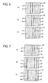
- FIG. 6 is a first diagram showing a lane-straddling state according to the embodiment of the present invention.
- FIG. 7 is a second diagram showing a lane-straddling state according to the embodiment of the present invention.
- FIG 8 is a third diagram showing a lane-straddling state according to the embodiment of the present invention.
- FIG. 9 is a second diagram showing a driving state of a vehicle according to the embodiment of the present invention.
- FIG. 10 is a diagram showing a display state for a host vehicle position according to the embodiment of the present invention.
- the reference symbol r1 denotes a road
- the reference symbols k1 to k3 denote lanes
- the reference symbols pr1, pr2 denote host vehicle positions
- the reference symbols ma denote road boundary lines
- the reference symbols m1, m2 denote lane boundary lines.
- the lane k1 is the recommended lane
- the lane k2 is the recommended lane.
- the image recognition processing portion of the guidance processing portion executes image recognition processing, reading in image data from the rear view camera 49 (FIG. 1) and, in this embodiment, recognizing in the image data, in an image field f1, the lane demarcation lines, which, in the examples in FIGS. 6 to 8, are the road boundary line ma and the lane boundary lines m1, m2.
- the angle of view of the rear view camera 49 in the horizontal direction that is, the horizontal angle of view, is set only to a value that allows two or more lane demarcation lines to be recognized, which value, in this embodiment, allows two lane demarcation lines to be recognized.
- a host vehicle position inference processing portion of the guidance processing portion executes host vehicle position inference processing, inferring whether or not the host vehicle is in the recommended lane.
- a straddling determination processing portion of the host vehicle position inference processing portion executes straddling determination processing, determining whether or not the host vehicle is straddling two specific lanes.
- the straddling determination processing portion determines from the position of the lane boundary line m1 whether or not the host vehicle is straddling the lanes k1, k2.
- the straddling determination processing portion determines that the host vehicle is straddling the lanes k1, k2. In a case where the position determination index ⁇ is less than 10% or greater than 90%, the straddling determination processing portion determines that the host vehicle is not straddling the lanes k1, k2.
- condition fulfillment determination processing portion of the host vehicle position inference processing portion executes condition fulfillment determination processing, starting a built-in timer in the CPU 31 and reading the current position.
- the condition fulfillment determination processing portion determines whether or not the conditions for determining a state of straddling the lanes k1, k2, that is, the determination conditions, have been fulfilled by determining whether or not the host vehicle has traveled while straddling the lanes k1, k2 while a pre-set specified time elapses and a pre-set specified distance is traveled.
- a straddling state determination processing portion of the host vehicle position inference processing portion executes straddling state determination processing, determining in what sort of state the host vehicle is straddling the lanes k1, k2 at the point in time when determination conditions are fulfilled.
- the straddling state determination processing portion determines that the host vehicle is straddling the lanes k1, k2 equally. If, as shown in shown in FIGS. 7A to 7C, the position determination index ⁇ is greater than 60% and not greater than 90%, the straddling state determination processing portion determines that the host vehicle is straddling the lanes k1, k2 more to the left. If, as shown in shown in FIGS. 8A to 8C, the position determination index ⁇ is not less than 10% and less than 40%, the straddling state determination processing portion determines that the host vehicle is straddling the lanes k1, k2 more to the right.
- the matter of whether or not the host vehicle is straddling the lanes k1, k2 and in what manner the host vehicle is straddling is determined according to the position of the lane boundary line m1, but the matter of whether or not the host vehicle is straddling the lanes k2, k3 and in what manner the host vehicle is straddling can be determined in the same manner according to the position of the lane boundary line m2.
- a host vehicle position determination processing portion of the host vehicle position inference processing portion executes host vehicle position determination processing, determining whether or not the host vehicle is in the recommended lane based on the fact that the lane was not specified by the lane specification processing, on the results of straddling determination processing, and on the results of straddling state determination processing.
- a candidate lane computation processing portion of the host vehicle position inference processing portion executes candidate lane computation processing, computing the lanes that are candidates for where the host vehicle is inferred to be, that is, candidate lanes.
- candidate lanes on the three-lane road r1, if the vehicle is in one of the lanes k1 to k3, it is possible to specify the driving lane, so the candidate lane computation processing portion does not compute the candidate lanes.
- the candidate lane computation processing portion computes the lanes k1 to k3 as the candidate lanes.
- the candidate lane computation processing portion does not compute the candidate lanes.
- the candidate lane computation processing portion computes the lanes k2, k3 as the candidate lanes.
- the candidate lane computation processing portion computes the lanes k1 to k4 as the candidate lanes.
- a driving lane assumption processing portion of the guidance processing portion executes driving lane assumption processing, in which the system assumes that the candidate lane that is farthest from the recommended lane is the driving lane.
- the host vehicle position determination processing portion determines that the host vehicle is not in the recommended lane, and the candidate lane computation processing portion computes the lanes k1 to k3 as the candidate lanes.
- the driving lane assumption processing portion assumes that the lane k3 is the driving lane, because the lane k3 is the lane farthest from the lane k1, the recommended lane.
- the lane guidance processing portion starts lane guidance in the form of voice phrases, timing the start of the lane guidance based on the distance required for the vehicle to move from the lane k3 to the recommended lane, that is, the required movement distance Lx.
- the guiding of the host vehicle into the recommended lane by means of lane guidance is executed in terms of an absolute position. Specifically, for example, a message such as "Turn left about 900 meters ahead. The farthest lane to the left is the recommended lane," or the like is output by voice. Also, thereafter, a message such as "The farthest lane to the left is the recommended lane,” or the like is output by voice to guide the host vehicle to the recommended lane by voice once again. Moreover, it becomes possible to specify the driving lane as the host vehicle changes lanes, so when the host vehicle has entered the recommended lane, a message such as "You have entered the recommended lane,” or the like is output by voice.
- the host vehicle position determination processing portion determines that the host vehicle is not in the recommended lane, and the candidate lane computation processing portion computes the lanes k1 to k3 as the candidate lanes.
- the driving lane assumption processing portion assumes that the lanes k1, k3 are the driving lanes, because the lanes k1, k3 are the lanes farthest from the lane k2, the recommended lane.
- the map display processing portion does not display the host vehicle position, as shown in FIG. 10.
- step S1 image recognition processing is executed.
- step S2 host vehicle position estimation processing is executed.
- step S3 driving lane assumption processing is executed.
- step S4 lane guidance processing is executed, and control is returned.
- FIG. 11 is a third diagram showing a driving state of a vehicle according to the embodiment of the present invention.
- FIG. 12 is a fourth diagram showing a driving state of a vehicle according to the embodiment of the present invention.
- FIG. 13 is a fifth diagram showing a driving state of a vehicle according to the embodiment of the present invention.
- FIG. 14 is a sixth diagram showing a driving state of a vehicle according to the embodiment of the present invention.
- the reference symbol r2 denotes a road
- the reference symbols k1 to k4 denote lanes
- the reference symbols pr1, pr2 denote host vehicle positions
- the reference symbols ma mb denote road boundary lines
- the reference symbols m1 to m3 denote lane boundary lines.
- the lane k1 is the recommended lane
- the lane k4 is the recommended lane
- the lane k2 is the recommended lane
- the lane k3 is the recommended lane.
- the host vehicle position determination processing portion executes host vehicle position determination processing, determining whether or not the host vehicle is in the recommended lane based on the fact that the lane was not specified by the lane specification processing, on the results of straddling determination processing, and on the results of straddling state determination processing.
- the driving lane assumption processing portion assumes the driving lane, based on the determination of whether or not the host vehicle is in the recommended lane.
- the host vehicle position determination processing portion determines that the host vehicle is not in the recommended lane, and the candidate lane computation processing portion computes the lanes k2, k3 as the candidate lanes.
- the driving lane assumption processing portion assumes that the lane k3 is the driving lane, because, of the lanes k2, k3, the lane k3 is the lane farthest from the lane k1, the recommended lane.
- the lane guidance processing portion starts lane guidance in the form of voice phrases, timing the start of the lane guidance based on the required movement distance Lx, the distance required for the vehicle to move from the lane k3 to the recommended lane.
- the guiding of the host vehicle into the recommended lane by means of lane guidance is executed in terms of an absolute position. Specifically, for example, a message such as "Turn left about 900 meters ahead. The farthest lane to the left is the recommended lane," or the like is output by voice. Also, thereafter, a message such as "The farthest lane to the left is the recommended lane,” or the like is output by voice to guide the host vehicle to the recommended lane by voice once again. Moreover, it becomes possible to specify the driving lane as the host vehicle changes lanes, so when the host vehicle has entered the recommended lane, a message such as "You have entered the recommended lane,” or the like is output by voice.
- the host vehicle position determination processing portion determines that the host vehicle is not in the recommended lane, and the candidate lane computation processing portion computes the lanes k2, k3 as the candidate lanes.
- the driving lane assumption processing portion assumes that the lane k2 is the driving lane, because, of the lanes k2, k3, the lane k2 is the lane farthest from the lane k4, the recommended lane.
- the lane guidance processing portion starts lane guidance in the form of voice phrases, timing the start of the lane guidance based on the required movement distance Lx, the distance required for the vehicle to move from the lane k2 to the recommended lane.
- the guiding of the host vehicle into the recommended lane by means of lane guidance is executed in terms of an absolute position. Specifically, for example, a message such as "Turn right about 900 meters ahead. The farthest lane to the right is the recommended lane," or the like is output by voice. Also, thereafter, a message such as "The farthest lane to the right is the recommended lane,” or the like is output by voice to guide the host vehicle to the recommended lane by voice once again. Moreover, it becomes possible to specify the driving lane as the host vehicle changes lanes, so when the host vehicle has entered the recommended lane, a message such as "You have entered the recommended lane,” or the like is output by voice.
- the host vehicle position determination processing portion determines that it is unclear whether or not the host vehicle is in the recommended lane, and the candidate lane computation processing portion computes the lanes k2, k3 as the candidate lanes.
- the driving lane assumption processing portion assumes that the lane k3 is the driving lane, because, of the lanes k2, k3, the lane k3 is the lane farthest from the lane k2, the recommended lane.
- the lane guidance processing portion starts lane guidance in the form of voice phrases, timing the start of the lane guidance based on the required movement distance Lx, the distance required for the vehicle to move from the lane k3 to the recommended lane.
- the guiding of the host vehicle into the recommended lane by means of lane guidance is executed in terms of an absolute position. Specifically, for example, a message such as "Turn left in 700 meters. The second lane from the left is the recommended lane," or the like is output by voice. Also, thereafter, a message such as "The second lane from the left is the recommended lane,” or the like is output by voice to guide the host vehicle to the recommended lane by voice once again. Moreover, it becomes possible to specify the driving lane as the host vehicle changes lanes, so when the host vehicle has entered the recommended lane, a message such as "You have entered the recommended lane,” or the like is output by voice.
- the host vehicle position determination processing portion determines that it is unclear whether or not the host vehicle is in the recommended lane, and the candidate lane computation processing portion computes the lanes k2, k3 as the candidate lanes.
- the driving lane assumption processing portion assumes that the lane k2 is the driving lane, because, of the lanes k2, k3, the lane k2 is the lane farthest from the lane k3, the recommended lane.
- the lane guidance processing portion starts lane guidance in the form of voice phrases, timing the start of the lane guidance based on the required movement distance Lx, the distance required for the vehicle to move from the lane k2 to the recommended lane.
- the guiding of the host vehicle into the recommended lane by means of lane guidance is executed in terms of an absolute position. Specifically, for example, a message such as "Turn right in 700 meters ahead. The third lane from the left is the recommended lane," or the like is output by voice. Also, thereafter, a message such as "The third lane from the left is the recommended lane,” or the like is output by voice to guide the host vehicle to the recommended lane by voice once again. Moreover, it becomes possible to specify the driving lane as the host vehicle changes lanes, so when the host vehicle has entered the recommended lane, a message such as "You have entered the recommended lane,” or the like is output by voice.
- the map display processing portion does not display the host vehicle position.
- the system can infer whether or not the host vehicle is in the recommended lane and, based on the inference results, assume the driving lane. Therefore, appropriate lane guidance can be executed, even in a case where the driving lane cannot be specified based on the driving history, a local feature, or the like.
- the host vehicle position in a case where the driving lane cannot be specified, is not displayed, but it is possible to display a host vehicle position in each of the candidate lanes or to display a host vehicle position with enlarged dimensions, so that it extends over a plurality of candidate lanes.
- a route guidance system includes a current position detection portion that detects a current position of a host vehicle as a host vehicle position; a route search processing portion that searches for a specified route to a destination, based on the host vehicle position; a recommended lane setting processing portion that sets a recommended lane based on the specified route; a host vehicle position inference processing portion that infers whether or not the host vehicle is in the recommended lane, based on image data of lane demarcation lines; a driving lane assumption processing portion that assumes that the lane in which the host vehicle is driving is the driving lane, based on the inference results of whether or not the host vehicle is in the recommended lane; and a lane guidance processing portion that executes lane guidance based on the assumed driving lane. Appropriate lane guidance can be executed, because the driving lane is assumed based on the inference results of whether or not the host vehicle is in the recommended lane.
Abstract
Description
- The disclosure of
Japanese Patent Application No. 2005-379920 filed on December 28, 2005 - The present invention relates to a route guidance system and a route guidance method.
- In a conventional navigation system, the current position of a vehicle that is a host vehicle, that is, one's current position, is detected by a Global Positioning System (GPS) device, for example. Map data is read out from a data storage portion, and a map screen is formed on a display unit. The host vehicle position, which indicates one's current position, a map of the area surrounding the host vehicle position, and the like are displayed on the map screen. Therefore, a driver can drive the vehicle according to the host vehicle position that is displayed on the map screen.
- When the driver inputs a destination and sets search conditions, route search processing is executed based on the search conditions, and a route to the destination from a departure position, which is expressed as the current position, is sought according to the map data. A route that is specified, that is, a specified route, is displayed on the map screen together with the host vehicle position. Guidance along the specified route, that is, route guidance, is executed. Therefore, the driver can drive the vehicle along the specified route that is displayed.
- In the navigation system configured as described above, in a case where a plurality of lanes is formed in a road, the lane in which the vehicle is driving, that is, a driving lane, can be specified based on a driving history of lanes driven, local features on the road, and the like.
- If the driving lane is specified, the specified route is sought by lane, and route guidance by lane, that is, lane guidance, is executed. For example, a lane that is recommended as the one in which the vehicle should travel is set as a recommended lane, and the vehicle is guided to the recommended lane.
- However, in the conventional navigation system, it is sometimes not possible to specify the driving lane based on the driving history, the local features on the road, and the like. In those cases, it becomes impossible to execute appropriate route guidance.
- It is an object of the present invention to provide a route guidance system and a route guidance method that solve a problem of the conventional navigation system by making it possible to execute appropriate route guidance even in a case where the driving lane cnnot be specified.
- For this purpose, a route guidance system according to one aspect of the present invention includes a current position detection portion that detects a current position of a host vehicle as a host vehicle position; a route search processing portion that searches for a specified route to a destination, based on the host vehicle position; a recommended lane setting processing portion that sets a recommended lane in which driving is recommended, based on the specified route; a host vehicle position inference processing portion that infers whether or not the host vehicle is in the recommended lane, based on image data of lane demarcation lines that are photographed by a photography unit; a driving lane assumption processing portion that assumes that the lane in which the host vehicle is driving is the driving lane, based on the inference results of whether or not the host vehicle is in the recommended lane; and a lane guidance processing portion that executes lane guidance based on the assumed driving lane.
- According to the present invention, appropriate lane guidance can be executed, even in a case where the driving lane cannot be specified, because the route guidance system infers whether or not the host vehicle is in the recommended lane, based on image data of lane demarcation lines; assumes that the lane in which the host vehicle is driving is the driving lane, based on the inference results; and executes lane guidance based on the assumed driving lane.
- FIG. 1 is a diagram showing a navigation system according to an embodiment of the present invention;
- FIG. 2 is a first diagram showing a driving lane specification method according to the embodiment of the present invention;
- FIG. 3 is a second diagram showing the driving lane specification method according to the embodiment of the present invention;
- FIG. 4 is a flowchart showing the operation of a guidance processing portion according to the embodiment of the present invention;
- FIG. 5 is a first diagram showing a driving state of a vehicle according to the embodiment of the present invention;
- FIG. 6 is a first diagram showing a lane-straddling state according to the embodiment of the present invention;
- FIG. 7 is a second diagram showing a lane-straddling state according to the embodiment of the present invention;
- FIG. 8 is a third diagram showing a lane-straddling state according to the embodiment of the present invention;
- FIG. 9 is a second diagram showing a driving state of a vehicle according to the embodiment of the present invention;
- FIG. 10 is a diagram showing a display state for a host vehicle position according to the embodiment of the present invention;
- FIG. 11 is a third diagram showing a driving state of a vehicle according to the embodiment of the present invention;
- FIG. 12 is a fourth diagram showing a driving state of a vehicle according to the embodiment of the present invention;
- FIG. 13 is a fifth diagram showing a driving state of a vehicle according to the embodiment of the present invention; and
- FIG 14 is a sixth diagram showing a driving state of a vehicle according to the embodiment of the present invention.
- An embodiment of the present invention will be explained below with reference to the drawings. Note that in this case, the navigation system is explained as a route guidance system.
- FIG. 1 is a diagram showing a navigation system according to the embodiment of the present invention.
- In FIG. 1, the
reference numeral 10 denotes an automatic transmission control portion that serves as a power train control portion. The automatictransmission control portion 10 controls a power train that shifts gears at a prescribed gear ratio, such as a continuously variable transmission (CVT) that serves as an automatic transmission, a stepped transmission (automatic transmission), an electric drive unit, or the like. - The
reference numeral 14 denotes a navigation unit that serves as an information terminal, such as an on-board unit that is mounted in a vehicle. The reference numeral 63 denotes a network, and thereference numeral 51 denotes an inform center that serves as an information provider. A navigation system is made up of the automatictransmission control portion 10, thenavigation unit 14, the network 63, theinformation center 51, and the like. - The
navigation unit 14 includes a Global Positioning System (GPS)sensor 15, adata storage portion 16, anavigation processing portion 17, adirection sensor 18, an operation portion 34, a display portion 35, avoice input portion 36, avoice output portion 37, and acommunications portion 38. TheGPS sensor 15 serves as a current position detection portion that detects the current position of the host vehicle. Thedata storage portion 16 serves as an information storage portion where map data and various other types of data are stored. Thenavigation processing portion 17 carries out various types of computational processing, such as navigation processing and the like, based on information that is input. Thedirection sensor 18 serves as a direction detection portion that detects the vehicle's direction. The operation portion 34 serves as a first input portion, by operating which the driver, who is the operator, makes a prescribed input. The display portion 35 serves as a first output portion that uses images displayed on a screen not shown in FIG. 1 to express various types of information and notify the driver. Thevoice input portion 36 serves as a second input portion for making a prescribed input by voice. Thevoice output portion 37 serves as a second output portion that uses voice to express various types of information and notify the driver. Thecommunications portion 38 serves as a transmitting and receiving portion that functions as a communications terminal. TheGPS sensor 15, thedata storage portion 16, thedirection sensor 18, the operation portion 34, the display portion 35, thevoice input portion 36, thevoice output portion 37, and thecommunications portion 38 are connected to thenavigation processing portion 17. - Also connected to the
navigation processing portion 17 are the automatictransmission control portion 10, a forward monitoring unit 48, a rear view camera (rear monitoring camera) 49, a front view camera (forward monitoring camera) 50, an accelerator sensor 42, a brake sensor 43, a vehicle speed sensor 44, and the like. The forward monitoring unit 48 is installed at a prescribed location on the front end of the vehicle and monitors the area in front of the vehicle. The rear view camera 49 is installed at a prescribed location on the rear end of the vehicle and serves as a photography unit that captures images of the area behind the vehicle and as a rear monitoring unit. The front view camera 50 is installed at a prescribed location on the front end of the vehicle and serves as a photography unit that captures images of the area in front of the vehicle and as a forward monitoring unit. The accelerator sensor 42 serves as an engine load detection portion that detects the driver's operation of an accelerator pedal not shown in FIG. 1, based on the accelerator angle. The brake sensor 43 serves as a braking detection portion that detects the driver's operation of a brake pedal not shown in FIG. 1, based on the amount by which the pedal is depressed. The vehicle speed sensor 44 serves as a vehicle speed detection portion that detects the vehicle speed. Note that the accelerator sensor 42, the brake sensor 43, and the like make up an operation information detection portion that detects information on the operation of the vehicle by the driver. It is also possible to use various types of cameras, such as side cameras or the like, as photography units to monitor the areas to the sides of the vehicle. - The
GPS sensor 15 detects the vehicle's current position on the Earth, as well as the time, by receiving radio waves generated by a satellite. In this embodiment, theGPS sensor 15 is used as the current position detection portion, but a distance sensor, a steering sensor, an altimeter, or the like not shown in FIG. 1 can also be used individually or in combination instead of theGPS sensor 15. A gyroscopic sensor, a geomagnetic sensor, or the like can be used as thedirection sensor 18. Note that in this embodiment, thedirection sensor 18, the vehicle speed sensor 44, and the like are installed, but where a GPS sensor having functions to detect the host vehicle direction, the vehicle speed, and the like is used, thedirection sensor 18, the vehicle speed sensor 44, and the like are not necessary. - The
data storage portion 16 is provided with a map data base made up of map data files, and map data is stored in the map data base. The map data includes intersection data pertaining to intersections, node data pertaining to nodes, road data pertaining to road links, search data that is processed for searching, facilities data pertaining to facilities, and the like, as well as local feature data pertaining to local features. - The local features are made up of displays installed or formed on the road to provide various kinds of driving-related information and guidance to drivers. These displays include marking lines, indicators, pedestrian crosswalks, manhole covers, traffic signals, and the like. Marking lines include stop lines on the road to stop vehicles, lane demarcation lines that are formed to delineate the boundaries of lanes on the road, demarcation lines that delineate parking spaces, and the like. Indicators include lane differentiation indicators in the form of arrows that are formed in each lane to indicate the direction of travel in the lane, and guidance indicators, such as the word "Stop" and the like, which warn of an approaching location where the vehicle must stop momentarily (including a point of entry into a priority road from a non-priority road, a railroad crossing, an intersection where a red signal flashes, and the like). Guidance indicators may also include phrases such as "To (place name)" and the like that are formed in a lane and provide directional guidance in the lane. Lane demarcation lines include road boundary lines that are formed as solid lines on a shoulder side of the road and on a side toward an oncoming traffic lane, as well as lane boundary lines that are formed as broken lines between individual lanes in an area bounded by road boundary lines.
- The local feature data include position information, which describes the position of each feature in terms of coordinates and the like, image information, which shows an image of each feature, and other information. Note that where a radio wave beacon unit, an optical beacon unit, or the like, which will be explained later, is treated as a local feature, current traffic information is sent to the vehicle using a different signal for each lane. Therefore, the signals that are sent from the radio wave beacon unit, the optical beacon unit, or the like are included in the local feature data.
- The road data pertaining to the lanes include lane data (lane information), including a number of lanes, which expresses the number of lanes on the road, a lane number that is assigned to each lane on the road, lane position information, and the like. Note that the lane data also includes information concerning a bus lane, that is, bus lane information, and information concerning a reversible lane, that is, reversible lane information.
- Note that data are also stored in the
data storage portion 16 in order for thevoice output portion 37 to output prescribed information. - A statistical data base made up of statistical data files and a driving history data base made up of driving history data files are also stored in the
data storage portion 16. The statistical data in the statistical data files and the driving history data in the driving history data files are stored as actual results data. - The statistical data is actual traffic information provided in the past, that is, historical information that describes a history. Traffic information provided in the past by traffic information centers and the like (not shown in FIG. 1) as information providers, such as the Vehicle Information and Communication System (VICS) center and the like, traffic census information, which is data on traffic volumes from traffic censuses for example provided by authorities like the Ministry of Land Infrastructure and Transport, and road timetable information and the like, also provided for example, by authorities like the Ministry of Land Infrastructure and Transport, are used individually or in combination. The statistical data is created by refining the information as necessary, then carrying out statistical processing. Note that congestion forecasting information and the like for forecasting congestion and other purposes can also be added. In that case, when the statistical data is created, detailed conditions are added to the historical information, such as information on dates and times, days of the week, weather, various types of events, seasons of the year, facilities (the presence or absence of department stores, supermarkets, and the like), and the like.
- Also, the data items in the statistical data are made up of link numbers for various road links, direction flags to indicate the direction of travel, information classifiers that show the type of information, degrees of congestion at specific times, link required times that describe the times required to travel on various road links at specific times, data on link required times averaged for each day of the week (for example, average time for Wednesday), and the like.
- The driving history data is made up of information collected by the
information center 51 from a plurality of vehicles, i.e., the host vehicle and other vehicles, and represents actual driving records of vehicles traveling on roads where each vehicle has traveled. That is, it is actual history information that describes driving records, and based on the driving data, probe data is computed and accumulated. - The data items in the driving history data are made up of link required times at specific times when vehicles traveled on each road link, degrees of congestion at specific times when vehicles traveled on each road link, and the like. Note that the driving history data can be added to the statistical data. In this embodiment, the degree of congestion is used as a congestion indicator that expresses the scale of congestion. Congestion, crowding, and non-congestion are expressed separately.
- In order to store the various types of data, the
data storage portion 16 includes a disk not shown in FIG. 1, such as a hard disk, a CD, a DVD, an optical disk, or the like. Thedata storage portion 16 also includes a read/write head or the like for reading and writing the various type of data. It is also possible to use a memory card or the like for thedata storage portion 16. Note that an external storage device is formed by the various disks, the memory card, or the like. - In this embodiment, the map data base, the statistical data base, the driving history data base, and the like are built in the
data storage portion 16, but the map data base, the statistical data base, the driving history data base, and the like can also be built in theinformation center 51. - The
navigation processing portion 17 includes aCPU 31, aRAM 32, a ROM 33, and a flash memory that is not shown in FIG. 1. TheCPU 31 serves as a control device that controls theentire navigation unit 14 and as a computation device. TheRAM 32 is used as working memory when theCPU 31 performs various types of computational processing. The ROM 33 contains a control program, as well as various types of programs that search for routes to destinations, execute route guidance, and so on. The flash memory is used to store various types of data, programs, and the like. Note that an internal storage device is formed by theRAM 32, the ROM 33, the flash memory, or the like. - In this embodiment, various types of programs can be stored in the ROM 33, and various types of data can be stored in the
data storage portion 16, but programs, data, and the like can also be stored on a disk or the like. In that case, programs, data, and the like that are read from the disk or the like can be written to the flash memory. The programs, data, and the like can therefore be updated by replacing the disk or the like. The control programs, data, and the like of the automatictransmission control portion 10 can also be stored on the disk or the like. The programs, data, and the like can be received through thecommunications portion 38 and written to the flash memory in thenavigation processing portion 17. - The operation portion 34 executes such tasks as correcting the current position when the vehicle starts to move, inputting a departure point and a destination, inputting points to be passed, and operating the
communications portion 38, all according to the driver's operations. The operation portion 34 can use a keyboard, mouse, or the like that is installed independently of the display portion 35. The operation portion 34 can also use a touch panel that is capable of executing prescribed input operations that are done by touching or clicking on an image operation portion, such as various types of keys, switches, buttons, and the like that are displayed as images on a screen that is formed by the display portion 35. - The display portion 35 is used as a display. Also, the various screens that are formed on the display portion 35 can display the vehicle's current position as the host vehicle's position; the vehicle's direction as the host vehicle's direction; maps, the specified route, guidance information along the specified route, traffic information, and the like; the distance to the next intersection on the specified route and the direction of travel at the next intersection. The screens can also display operation guidance, operation menus, and key guidance for the image operation portion, the operation portion 34, the
voice input portion 36, and the like. The screens can also display programs and the like that are broadcast by FM multiplex. - The
voice input portion 36 includes a microphone that is not shown in FIG. 1 and can input required information by voice. Thevoice output portion 37 includes a voice synthesizing unit and a speaker, which are not shown in FIG. 1. Thevoice output portion 37 outputs the specified route, the guidance information, the traffic information, and the like by means of a voice that is synthesized by the voice synthesizing unit, for example. - The
communications portion 38 includes a beacon receiver and an FM receiver for receiving various types of the information, such as current traffic information that is transmitted from the traffic information center, general information, and the like. The beacon receiver receives the information as radio wave signals or optical signals via radio wave beacons or optical beacons installed along the road. The FM receiver receives the information as FM multiplex broadcasts via an FM broadcast station. Note that the traffic information includes congestion information, regulatory information, parking space information, traffic accident information, service area congestion status information, and the like. The general information includes news, weather forecasts, and the like. The beacon receiver and the FM receiver are combined in a single VICS receiver, but they can also be installed separately. - The traffic information contains an information classification that defines the type of information, a mesh number that specifies a mesh, a link number that specifies a road link connecting two points (e.g., two intersections) and also distinguishes between inbound and outbound halves of the road, link information that constitutes the content of the information that is provided for the corresponding link number. For example, if the traffic information is congestion information, the link information is made up of congestion leading edge data, which tells the distance from the start of the road link to the leading edge of the congestion; the degree of congestion; a congestion length, which tells the distance from the leading edge of the congestion to its trailing edge; the link required time, which tells the time required to travel the road link; and so on.
- The
communications portion 38 can also receive map data, statistical data, driving history data, and the like, as well as various types of the information such as traffic information, general information, and the like, via the network 63. - For that reason, the
information center 51 includes a server 53, a communications portion 57 connected to the server 53, a data base 58 that serves as an information storage portion, and so on. The server 53 includes a CPU 54, a RAM 55, and a ROM 56. The CPU 54 serves as a control device and as a computation device. The data base 58 stores the same sort of data that is stored in thedata storage portion 16, such as map data statistical data, and driving history data, for example. Theinformation center 51 can also provide in real time various types of the information, such as current traffic information that is transmitted from the traffic information center, general information, and the like, as well as driving history data that is collected from a plurality of vehicles (the host vehicle and other vehicles). - The forward monitoring unit 48 is made up of a radar, such as a laser radar, a millimeter-wave radar, or the like, or an ultrasonic sensor or the like, or a combination of a radar or the like and an ultrasonic sensor or the like. The forward monitoring unit 48 monitors a vehicle that is traveling ahead of the host vehicle, that is, a vehicle ahead, and also monitors momentary stopping points, obstacles, and the like. The forward monitoring unit 48 also detects the relative speed, which is the vehicle speed relative to the vehicle ahead, the approach speed in relation to momentary stopping points, the approach speed in relation to obstacles, the distance to the vehicle ahead, the time to the vehicle ahead, and the like, all as information about the area around the host vehicle.
- The rear view camera 49 is made up of a CCD device and is mounted so that its optical axis tilts downward in order to monitor the area behind the vehicle. In addition to the local features, the subjects for image capture include a vehicle behind, which is a vehicle traveling behind the host vehicle, buildings and other structures on the roadside, and the like. The rear view camera 49 generates image data of the photographed subjects and sends the data to the
CPU 31. In the same manner the front view camera 50 is made up of a CCD device and is mounted so that its optical axis tilts downward in order to monitor the area in front of the vehicle. In addition to the local features, the subjects for image capture include a vehicle ahead, which is a vehicle traveling in front of the host vehicle, buildings and other structures on the roadside, guidance indicators installed above the road that use arrows to indicate the direction of travel in each lane, and the like. The front view camera 50 generates image data of the photographed subjects and sends the data to theCPU 31. TheCPU 31 reads the image data and executes image processing on the image data to recognize individual photographed subjects as recognized objects. In this embodiment, a CCD device is used as the rear view camera 49 and as the front view camera 50, but a C-MOS device or the like can be used. - Note that the navigation system, the
control portion 10, thenavigation processing portion 17, theCPUs 31, 54, the server 53, and the like function as computers, independently or in combinations of two or more, and execute computational processing based on various types of programs, data, and the like. Also, storage media are made up of thedata storage portion 16, theRAMs 32, 55, the ROMs 33, 56, the data base 58, the flash memories, and the like. Also, microprocessors or the like can be used as computation devices in place of theCPUs 31, 54. - Next, the basic operation of the navigation system described above will be explained.
- First, when the driver operates the operation portion 34 and the
navigation unit 14 starts up, a navigation initialization processing portion (not shown in FIG 1) of theCPU 31 executes navigation initialization processing, reads the current position of the host vehicle detected by theGPS sensor 15, reads the host vehicle direction detected by thedirection sensor 18, and initializes various types of data. Next, a matching processing portion (not shown in FIG. 1) of theCPU 31 executes matching processing, reads the current position, and specifies the current position by judging on which road link the current position lies, based on the track of the current position that was read, the shapes and arrangement of the various road links that make up the roads in the vicinity of the current position, and so on. - Also, in this embodiment, the matching processing portion further specifies the current position based on the positions of various local features that are photographed subjects photographed by the rear view camera 49.
- For that purpose, an image recognition processing portion of the
CPU 31, not shown in FIG. 1, executes image recognition processing, reading in image data from the rear view camera 49 and recognizing a local feature in an image formed from the image data. Also, a distance computation processing portion of theCPU 31, not shown in FIG. 1, executes distance computation processing, computing a distance from the rear view camera 49 to the actual local feature, based on the position of the local feature in the image. A current position specification processing portion of the matching processing portion executes current position specification processing, reading in the distance to the local feature and reading local feature data from thedata storage portion 16 to obtain the coordinates of the local feature, then specifying the current position based on the coordinates and the distance to the local feature. Note that it is also possible to specify the current position based on a position of a local feature that is photographed by the front view camera 50, instead of by the rear view camera 49. - A lane specification processing portion of the
CPU 31, not shown in FIG. 1, executes lane specification processing, specifying the driving lane based on a driving history of lanes driven or based on a local feature or the like that is recognized based on the image data or, as necessary, specifying the driving lane based on a result of checking the local feature against the local feature data that are read from thedata storage portion 16. The driving lane can also be specified based on results of detecting the current position by using the highlyprecise GPS sensor 15. - Note that that where the local feature is made of a strongly magnetic substance such as steel or the like, as in the case of a manhole cover or the like, the lane specification processing portion can read a sensor output from the geomagnetic sensor, determine whether or not a manhole cover or the like is present based on the sensor output, and specify the driving lane based on the results of the determination. Also, as necessary, the driving lane can be specified by combining the sensor output from the geomagnetic sensor, the current position, and the like at the same time that image processing is executed on the image data of the marking lines.
- A basic information acquisition processing portion of the
CPU 31, not shown in FIG. 1, executes basic information acquisition processing, obtaining map data from thedata storage portion 16 or receiving map data from theinformation center 51 or the like via thecommunications portion 38. Note that when map data is obtained from theinformation center 51 or the like, the basic information acquisition processing portion writes the received data to the flash memory. - A display processing portion of the
CPU 31, not shown in FIG. 1, executes display processing, forming various types of screens on the display portion 35. For example, a map display processing portion of the display processing portion executes map display processing, forming a map display screen on the display portion 35 that displays the current position as the host vehicle position and the vehicle direction as the host vehicle direction, while also displaying maps of the areas surrounding the map screen. - Therefore, the driver is able to drive the vehicle according to the map, the host vehicle position, and the host vehicle direction.
- When the driver operates the operation portion 34 to input a destination, a destination setting processing portion of the
CPU 31, not shown in FIG. 1, executes destination setting processing and sets the destination. Note that the departure point can also be input and set as necessary. It is also possible to register a given location in advance, then set the registered location as the destination. When the driver operates the operation portion 34 to input a search condition, a search condition setting processing portion of theCPU 31, not shown in FIG. 1, executes search condition setting processing and sets the search condition. - When the destination and search condition are set in this manner, a route search processing portion of the
CPU 31, not shown in FIG 1, executes route search processing. The route search processing portion reads the current position, the destination, the search condition, and the like, and also reads search data and the like from thedata storage portion 16. Based on the current position, the destination, and the search data, the route search processing portion searches for a route from the departure point, expressed as the current position, to the destination, according to the search condition. The route search processing portion outputs route data that describe the specified route. The specified route is the route for which the total of the link costs assigned to each road link is the lowest. - Also, if a plurality of lanes are formed in the road, and if the driving lane has been specified, the route search processing portion specifies individual lanes in the specified route. In that case, the lane numbers of the driving lanes and the like are included in the route data.
- Note that route search processing can be executed at the
information center 51. In that case, theCPU 31 transmits the current position, the destination, the search condition, and the like to theinformation center 51. When theinformation center 51 receives the current position, the destination, the search condition, and the like, a route search processing portion of the CPU 54, not shown in FIG. 1, executes route search processing in the same manner asCPU 31. The route search processing portion reads search data from the data base 58 and based on the current position, the destination, and the search data, searches for a route from the departure point to the destination, according to the search condition. The route search processing portion outputs route data that describe the specified route. Next, a transmission processing portion of the CPU 54, not shown in FIG 1, executes transmission processing, transmitting the route data to thenavigation unit 14. - Next, a guidance processing portion of the
CPU 31, not shown in FIG 1, executes guidance processing and provides route guidance. For this purpose, a route display processing portion of the guidance processing portion executes route display processing, reading the route data and displaying the specified route on the map screen according to the route data. - Incidentally, when the vehicle must turn right or left at a prescribed intersection, the intersection is set as a guidance point and as a guidance intersection for route guidance.
- For that purpose, a guidance intersection setting processing portion of the guidance processing portion executes guidance intersection setting processing. The guidance intersection setting processing portion determines, according to the route data, that is, based on the specified route, whether or not there is an intersection where the vehicle must turn right or left. If there is an intersection where the vehicle must turn right or left, the intersection is set as a guidance intersection.
- When individual lanes have been specified in the specified route, a recommended lane setting processing portion of the guidance processing portion executes recommended lane setting processing, selecting lanes that are recommended as the ones in which the vehicle should travel and setting them as the recommended lanes. For example, when the vehicle passes through a guidance intersection, the recommended lane setting processing portion selects and sets a suitable lane for entering the guidance intersection, a suitable lane for exiting the guidance intersection, and so on. Also, the route display processing portion, in addition to displaying the specified route on the map screen, displays an enlarged map of the road where the vehicle is traveling, that is, an enlarged road map, in a specified area of the map screen and uses the enlarged road map to provide lane guidance. In this case, each lane, as well as each specifically recommended lane, is displayed on the enlarged road map.
- Next, a voice output processing portion of the guidance processing portion executes voice output processing, outputting route guidance by voice from the
voice output portion 37. For this purpose, a route guidance point setting processing portion of the voice output processing portion executes route guidance point setting processing, setting one or more route guidance points at locations at pre-set distances before the guidance intersection on the specified route (i.e., on the side of the guidance intersection where the host vehicle is located). Also, a point guidance processing portion of the guidance processing portion executes point guidance processing. When the vehicle arrives at a route guidance point, route guidance is provided for the guidance intersection in the form of voice phrases with a content that is set in advance for each of the route guidance points, such as the distance from the host vehicle position to the guidance intersection, whether the vehicle turns left or right at the guidance intersection, and the like. Also, if the recommended lane has been set, a lane guidance processing portion of the guidance processing portion executes lane guidance processing, providing lane guidance in the form of voice phrases with a content that is set in advance for each of the route guidance points, such as each recommended lane from the host vehicle position to the guidance intersection, the recommended lane beyond the guidance intersection, and the like. Also, in a case where the driving lane is different from the recommended lane, the lane guidance processing portion guides the vehicle from the driving lane to the recommended lane. Therefore, it is possible for the driver to drive the vehicle in the recommended lane. - Also, an enlarged guidance point map display processing portion of the guidance processing portion executes enlarged guidance point map display processing. The enlarged guidance point map display processing portion reads the intersection data and, before the vehicle arrives at the guidance intersection, displays an enlarged map of the guidance intersection, that is, an enlarged intersection map, in a specified area of the map screen, using the enlarged intersection map to provide route guidance. In this case, a map of the area surrounding the guidance intersection, the specified route, and landmarks such as facilities and the like at the guidance intersection are displayed on the enlarged intersection map. Also, in a case where a plurality of lanes is formed in the road by which the vehicle enters the guidance intersection (hereinafter called the entry road) or in the road by which the vehicle exits the guidance intersection (hereinafter called the exit road) and lane guidance is executed, the enlarged guidance point map display processing portion displays the recommended lanes on the enlarged intersection map. For that purpose, the intersection data includes an intersection name, the entry road, the exit road, the presence or absence of a traffic signal, the type of traffic signal, and the like.
- Incidentally, as explained earlier, the lane specification processing portion specifies the driving lane based on a driving history of lanes driven or based on a local feature or the like that is recognized based on the image data or, as necessary, specifies the driving lane based on the result of checking the local feature against the local feature data that are read from the
data storage portion 16. - However, it is sometimes not possible to specify the driving lane based on the driving history, a local features, and the like.
- For example, in a case where the driving lane is specified based on the driving history, it might become impossible to specify the driving lane as the vehicle passes through an intersection, turns right or left, or goes straight ahead, because no lane demarcation lines are formed in the intersection. Also, in a case where the number of driving lanes on a road increases, it might become impossible to specify the driving lane, because the lane demarcation lines change. Moreover, it might become impossible to specify the driving lane even in a case where the vehicle is driving without moving between lanes.
- Also, in a case where the driving lane is specified based on a local feature or the like, it might become impossible to specify the driving lane if the image data cannot be used because there are no local features particular to a lane. It might also become impossible to specify the driving lane in a case where there is no radio wave beacon, optical beacon, or the like, because it is not possible to use local feature data.
- Therefore, it is conceivable to specify the driving lane based on the relationship between the road boundary lines and the lane boundary lines among the lane demarcation lines.
- FIG. 2 is a first diagram showing a driving lane specification method according to the embodiment of the present invention. FIG. 3 is a second diagram showing the driving lane specification method according to the embodiment of the present invention.
- In the diagrams, the reference symbols r1, r2 denote roads, the reference symbols k1 to k4 denote lanes, the reference symbol ma denotes road boundary lines that are formed as solid lines on the shoulder sides of the roads, the reference symbol mb denotes road boundary lines that are formed as solid lines on the sides toward the oncoming traffic lanes, the reference symbols m1 to m3 denote lane boundary lines that are formed as broken lines between lanes k1, k2, between lanes k2, k3, and between lanes k3, k4. Lane demarcation lines are made up of the road boundary lines ma, mb and lane boundary lines m1 to m3.
- For example, on the three-lane road r1, which has three lanes, the road boundary lines ma, mb are formed as solid lines on the shoulder side of the road and the side toward the oncoming traffic lane. The two lane boundary lines m1, m2 are formed as broken lines between the road boundary lines ma, mb. Therefore, if the road boundary line ma and the lane boundary line m1 are recognized based on the image data of the lane demarcation lines, the lane k1 can be specified as the driving lane. If the lane boundary lines m1, m2 are recognized, the lane k2 can be specified as the driving lane. If the lane boundary line m2 and the road boundary line mb are recognized, the lane k3 can be specified as the driving lane.
- Also, on the four-lane road r2, which has four lanes, the road boundary lines ma, mb are formed as solid lines on the shoulder side of the road and the side toward the oncoming traffic lane. The three lane boundary lines m1 to m3 are formed as broken lines between the road boundary lines ma, mb. Therefore, if the road boundary line ma and the lane boundary line m1 are recognized based on the image data of the lane demarcation lines, the lane k1 can be specified as the driving lane, because the road boundary line ma is a solid line and the lane boundary line m1 is a broken line. If the lane boundary line m3 and the road boundary line mb are recognized, the lane k4 can be specified as the driving lane, because the lane boundary line m3 is a broken line and the road boundary line mb is a solid line. In contrast to these situations, if the lane boundary lines m1, m2 are recognized, or if the lane boundary lines m2, m3 are recognized, it is not clear whether the lane k2 or the lane k3 is the driving lane, because the lane boundary lines m1, m2 and the lane boundary lines m2, m3 are all broken lines. Therefore, it is not possible to specify the lane k2 or the lane k3 as the driving lane.
- Thus, based on the relationship between the road boundary lines ma, mb and the lane boundary lines m1 to m3, the lane specification processing portion is able to specify the lanes k1 to k3 as the driving lane on the three-lane road r1 and to specify the lanes k1, k4 as the driving lane on the four-lane road r2.
- However, on the three-lane road r1, it is not possible to specify the driving lane if the vehicle is straddling the lanes k1, k2 or is straddling the lanes k2, k3. On the four-lane road r2, it is not possible to specify the driving lane if the vehicle is in the lanes k2, k3 outside the driving lanes k1, k4, is straddling the lanes k1, k2, is straddling the lanes k2, k3, or is straddling the lanes k3, k4.
- Therefore, in this embodiment, in a case where the lane specification processing portion cannot specify the driving lane, the guidance processing portion assumes that the lane in which the host vehicle is driving is the driving lane and executes lane guidance based on the assumed driving lane.
- A case where the driving lane is assumed on the three-lane road r1 will be explained first.
- FIG. 4 is a flowchart showing the operation of a guidance processing portion according to the embodiment of the present invention. FIG. 5 is a first diagram showing a driving state of a vehicle according to the embodiment of the present invention. FIG. 6 is a first diagram showing a lane-straddling state according to the embodiment of the present invention. FIG. 7 is a second diagram showing a lane-straddling state according to the embodiment of the present invention. FIG 8 is a third diagram showing a lane-straddling state according to the embodiment of the present invention. FIG. 9 is a second diagram showing a driving state of a vehicle according to the embodiment of the present invention. FIG. 10 is a diagram showing a display state for a host vehicle position according to the embodiment of the present invention.
- In the diagrams, the reference symbol r1 denotes a road, the reference symbols k1 to k3 denote lanes, the reference symbols pr1, pr2 denote host vehicle positions, the reference symbols ma, mb denote road boundary lines, and the reference symbols m1, m2 denote lane boundary lines. Note that in FIG. 5, the lane k1 is the recommended lane, and in FIG. 9, the lane k2 is the recommended lane.
- In these cases, the image recognition processing portion of the guidance processing portion executes image recognition processing, reading in image data from the rear view camera 49 (FIG. 1) and, in this embodiment, recognizing in the image data, in an image field f1, the lane demarcation lines, which, in the examples in FIGS. 6 to 8, are the road boundary line ma and the lane boundary lines m1, m2. For that purpose, the angle of view of the rear view camera 49 in the horizontal direction, that is, the horizontal angle of view, is set only to a value that allows two or more lane demarcation lines to be recognized, which value, in this embodiment, allows two lane demarcation lines to be recognized.
- Next, a host vehicle position inference processing portion of the guidance processing portion executes host vehicle position inference processing, inferring whether or not the host vehicle is in the recommended lane.
- For that purpose, a straddling determination processing portion of the host vehicle position inference processing portion executes straddling determination processing, determining whether or not the host vehicle is straddling two specific lanes.
- For example, as shown in FIGS. 6 to 8, in a case where the lane
boundary line m 1 is present in the image field f1, the straddling determination processing portion determines from the position of the lane boundary line m1 whether or not the host vehicle is straddling the lanes k1, k2. Specifically, in the image field f1, the straddling determination processing portion computes a number of pixels NL from a left edge e1 to the lane demarcation line m1 and a number of pixels NR from a right edge e2 to the lane demarcation line m1, then computes a percentage, a position determination index γ, that expresses the ratio of the number of pixels NL to the total number of pixels NL, NR:
- In a case where the position determination index γ is not less than 10% and not greater than 90%, the straddling determination processing portion determines that the host vehicle is straddling the lanes k1, k2. In a case where the position determination index γ is less than 10% or greater than 90%, the straddling determination processing portion determines that the host vehicle is not straddling the lanes k1, k2.
- If it is determined that the host vehicle is straddling the lanes k1, k2, a condition fulfillment determination processing portion of the host vehicle position inference processing portion executes condition fulfillment determination processing, starting a built-in timer in the
CPU 31 and reading the current position. The condition fulfillment determination processing portion then determines whether or not the conditions for determining a state of straddling the lanes k1, k2, that is, the determination conditions, have been fulfilled by determining whether or not the host vehicle has traveled while straddling the lanes k1, k2 while a pre-set specified time elapses and a pre-set specified distance is traveled. - Next, if the conditions are fulfilled and the host vehicle has traveled for the specified time and the specified distance while straddling the lanes k1, k2, a straddling state determination processing portion of the host vehicle position inference processing portion executes straddling state determination processing, determining in what sort of state the host vehicle is straddling the lanes k1, k2 at the point in time when determination conditions are fulfilled.
- Specifically, if, as shown in shown in FIGS. 6A to 6C, the position determination index γ is not less than 40% and not greater than 60%, the straddling state determination processing portion determines that the host vehicle is straddling the lanes k1, k2 equally. If, as shown in shown in FIGS. 7A to 7C, the position determination index γ is greater than 60% and not greater than 90%, the straddling state determination processing portion determines that the host vehicle is straddling the lanes k1, k2 more to the left. If, as shown in shown in FIGS. 8A to 8C, the position determination index γ is not less than 10% and less than 40%, the straddling state determination processing portion determines that the host vehicle is straddling the lanes k1, k2 more to the right.
- Note that in the examples shown in FIGS. 6 to 8, the matter of whether or not the host vehicle is straddling the lanes k1, k2 and in what manner the host vehicle is straddling is determined according to the position of the lane boundary line m1, but the matter of whether or not the host vehicle is straddling the lanes k2, k3 and in what manner the host vehicle is straddling can be determined in the same manner according to the position of the lane boundary line m2.
- Next, a host vehicle position determination processing portion of the host vehicle position inference processing portion executes host vehicle position determination processing, determining whether or not the host vehicle is in the recommended lane based on the fact that the lane was not specified by the lane specification processing, on the results of straddling determination processing, and on the results of straddling state determination processing.
- If it is not clear whether or not the host vehicle is in the recommended lane (it might be or it might not be), or if the host vehicle is not in the recommended lane, a candidate lane computation processing portion of the host vehicle position inference processing portion executes candidate lane computation processing, computing the lanes that are candidates for where the host vehicle is inferred to be, that is, candidate lanes. In this case, on the three-lane road r1, if the vehicle is in one of the lanes k1 to k3, it is possible to specify the driving lane, so the candidate lane computation processing portion does not compute the candidate lanes. In contrast, if the vehicle is straddling the lanes k1, k2, or is straddling the lanes k2, k3, it is not possible to specify the driving lane. Therefore, the candidate lane computation processing portion computes the lanes k1 to k3 as the candidate lanes.
- Also, on the four-lane road r2, if the vehicle is in the lane k1 or the lane k4, it is possible to specify the driving lane, so the candidate lane computation processing portion does not compute the candidate lanes. In contrast, if the vehicle is in the lane k2 or the lane k3, is straddling the lanes k1, k2, is straddling the lanes k2, k3, or is straddling the lanes k3, k4, it is not possible to specify the driving lane. Therefore, if the vehicle is in the lane k2 or the lane k3, the candidate lane computation processing portion computes the lanes k2, k3 as the candidate lanes. If the vehicle is straddling the lanes k1, k2, is straddling the lanes k2, k3, or is straddling the lanes k3, k4, the candidate lane computation processing portion computes the lanes k1 to k4 as the candidate lanes.
- Next, a driving lane assumption processing portion of the guidance processing portion executes driving lane assumption processing, in which the system assumes that the candidate lane that is farthest from the recommended lane is the driving lane.
- For example, in a case where the vehicle is straddling the lanes k1, k2 equally, as shown in FIG. 5 by the host vehicle position pr1, or is straddling the lanes k2, k3 equally, as shown in FIG. 5 by the host vehicle position pr2, the host vehicle position determination processing portion determines that the host vehicle is not in the recommended lane, and the candidate lane computation processing portion computes the lanes k1 to k3 as the candidate lanes. The driving lane assumption processing portion assumes that the lane k3 is the driving lane, because the lane k3 is the lane farthest from the lane k1, the recommended lane.
- Next, the lane guidance processing portion starts lane guidance in the form of voice phrases, timing the start of the lane guidance based on the distance required for the vehicle to move from the lane k3 to the recommended lane, that is, the required movement distance Lx.
- For example, in a case where the system will guide the host vehicle into the recommended lane, it is possible to set a point h1 at which the lane guidance will start, to set a point h2 where interim lane guidance will be executed 300 meters before the guidance intersection, and to compute a distance Lh1 from the point h1 to the guidance intersection as described below.
- Specifically, when a unit movement distance required to move one lane is set to 250 meters, if the vehicle speed is 60 km/h, the per-second speed can be expressed as almost 17 meters per second. The required movement distance Lx is the distance required to move two lanes, from the lane k3 to the lane k1, so it is expressed as follows:

- If the time required to output voice phrases to guide the host vehicle into the recommended lane, that is, a guidance time τ1, is 3 seconds, and, when the vehicle has entered the recommended lane, the time required to output voice phrases to the effect that the vehicle has entered the recommended lane, that is, a reporting time τ2, is 2 seconds, then the distance Lh1 is expressed as follows:

That is, the lane guidance must start at the point h1 885 meters before the guidance intersection. - In this case, it has been determined that the host vehicle is not in the recommended lane, so the guiding of the host vehicle into the recommended lane by means of lane guidance is executed in terms of an absolute position. Specifically, for example, a message such as "Turn left about 900 meters ahead. The farthest lane to the left is the recommended lane," or the like is output by voice. Also, thereafter, a message such as "The farthest lane to the left is the recommended lane," or the like is output by voice to guide the host vehicle to the recommended lane by voice once again. Moreover, it becomes possible to specify the driving lane as the host vehicle changes lanes, so when the host vehicle has entered the recommended lane, a message such as "You have entered the recommended lane," or the like is output by voice.
- Also, in a case where the host vehicle is straddling the lanes k1, k2 equally, as shown in FIG 9 by the host vehicle position pr1, or is straddling the lanes k2, k3 equally, as shown in FIG. 9 by the host vehicle position pr2, the host vehicle position determination processing portion determines that the host vehicle is not in the recommended lane, and the candidate lane computation processing portion computes the lanes k1 to k3 as the candidate lanes. The driving lane assumption processing portion assumes that the lanes k1, k3 are the driving lanes, because the lanes k1, k3 are the lanes farthest from the lane k2, the recommended lane.
- Therefore, the required movement distance Lx is the distance required to move one lanes, from the lanes k1, k3 to the lane k2, so it is expressed as follows:

The distance Lh1 is expressed as follows:
That is, the lane guidance must start at the point h1 635 meters before the guidance intersection. - Note that, as described above, the driving lane cannot be specified, so the map display processing portion does not display the host vehicle position, as shown in FIG. 10.
- Next, the flowchart will be explained.
At step S1, image recognition processing is executed.
At step S2, host vehicle position estimation processing is executed.
At step S3, driving lane assumption processing is executed.
At step S4, lane guidance processing is executed, and control is returned. - Next, a case will be explained in which the driving lane on the four-lane road r2 is assumed.
- FIG. 11 is a third diagram showing a driving state of a vehicle according to the embodiment of the present invention. FIG. 12 is a fourth diagram showing a driving state of a vehicle according to the embodiment of the present invention. FIG. 13 is a fifth diagram showing a driving state of a vehicle according to the embodiment of the present invention. FIG. 14 is a sixth diagram showing a driving state of a vehicle according to the embodiment of the present invention.
- In the diagrams, the reference symbol r2 denotes a road, the reference symbols k1 to k4 denote lanes, the reference symbols pr1, pr2 denote host vehicle positions, the reference symbols ma, mb denote road boundary lines, and the reference symbols m1 to m3 denote lane boundary lines. Note that in FIG. 11, the lane k1 is the recommended lane; in FIG. 12, the lane k4 is the recommended lane; in FIG. 13, the lane k2 is the recommended lane; in FIG. 14, the lane k3 is the recommended lane.
- In these cases, the host vehicle position determination processing portion executes host vehicle position determination processing, determining whether or not the host vehicle is in the recommended lane based on the fact that the lane was not specified by the lane specification processing, on the results of straddling determination processing, and on the results of straddling state determination processing. The driving lane assumption processing portion assumes the driving lane, based on the determination of whether or not the host vehicle is in the recommended lane.
- For example, in a case where the host vehicle is in the lane k2, as shown in FIG. 11 by the host vehicle position pr1, or where the host vehicle is in the lane k3, the host vehicle position determination processing portion determines that the host vehicle is not in the recommended lane, and the candidate lane computation processing portion computes the lanes k2, k3 as the candidate lanes. The driving lane assumption processing portion assumes that the lane k3 is the driving lane, because, of the lanes k2, k3, the lane k3 is the lane farthest from the lane k1, the recommended lane.
- Next, the lane guidance processing portion starts lane guidance in the form of voice phrases, timing the start of the lane guidance based on the required movement distance Lx, the distance required for the vehicle to move from the lane k3 to the recommended lane.
- For example, in a case where the system will guide the host vehicle into the recommended lane, the required movement distance Lx is the distance required to move two lanes, from the lane k3 to the lane k1, so it is expressed as follows:

Also, the distance Lh1 is expressed as follows:
That is, the lane guidance must start at the point h1 885 meters before the guidance intersection. - In this case, it has been determined that the host vehicle is not in the recommended lane, so the guiding of the host vehicle into the recommended lane by means of lane guidance is executed in terms of an absolute position. Specifically, for example, a message such as "Turn left about 900 meters ahead. The farthest lane to the left is the recommended lane," or the like is output by voice. Also, thereafter, a message such as "The farthest lane to the left is the recommended lane," or the like is output by voice to guide the host vehicle to the recommended lane by voice once again. Moreover, it becomes possible to specify the driving lane as the host vehicle changes lanes, so when the host vehicle has entered the recommended lane, a message such as "You have entered the recommended lane," or the like is output by voice.
- Also, in a case where the host vehicle is in the lane k2, as shown in FIG 12 by the host vehicle position pr1, or where the host vehicle is in the lane k3, the host vehicle position determination processing portion determines that the host vehicle is not in the recommended lane, and the candidate lane computation processing portion computes the lanes k2, k3 as the candidate lanes. The driving lane assumption processing portion assumes that the lane k2 is the driving lane, because, of the lanes k2, k3, the lane k2 is the lane farthest from the lane k4, the recommended lane.
- Next, the lane guidance processing portion starts lane guidance in the form of voice phrases, timing the start of the lane guidance based on the required movement distance Lx, the distance required for the vehicle to move from the lane k2 to the recommended lane.
- For example, in a case where the system will guide the host vehicle into the recommended lane, the required movement distance Lx is the distance required to move two lanes, from the lane k2 to the lane k4, so it is expressed as follows:

Also, the distance Lh1 is expressed as follows:
That is, the lane guidance must start at the point h1 885 meters before the guidance intersection. - In this case, it has been determined that the host vehicle is not in the recommended lane, so the guiding of the host vehicle into the recommended lane by means of lane guidance is executed in terms of an absolute position. Specifically, for example, a message such as "Turn right about 900 meters ahead. The farthest lane to the right is the recommended lane," or the like is output by voice. Also, thereafter, a message such as "The farthest lane to the right is the recommended lane," or the like is output by voice to guide the host vehicle to the recommended lane by voice once again. Moreover, it becomes possible to specify the driving lane as the host vehicle changes lanes, so when the host vehicle has entered the recommended lane, a message such as "You have entered the recommended lane," or the like is output by voice.
- Also, in a case where the host vehicle is in the lane k2, as shown in FIG. 13 by the host vehicle position pr1, or where the host vehicle is in the lane k3, the host vehicle position determination processing portion determines that it is unclear whether or not the host vehicle is in the recommended lane, and the candidate lane computation processing portion computes the lanes k2, k3 as the candidate lanes. The driving lane assumption processing portion assumes that the lane k3 is the driving lane, because, of the lanes k2, k3, the lane k3 is the lane farthest from the lane k2, the recommended lane.
- Next, the lane guidance processing portion starts lane guidance in the form of voice phrases, timing the start of the lane guidance based on the required movement distance Lx, the distance required for the vehicle to move from the lane k3 to the recommended lane.
- For example, in a case where the system will guide the host vehicle into the recommended lane, the required movement distance Lx is the distance required to move one lane, from the lane k3 to the lane k2, so it is expressed as follows:

Also, the distance Lh1 is expressed as follows:
That is, the lane guidance must start at the point h1 635 meters before the guidance intersection. - In this case, it has been determined that the host vehicle is not in the recommended lane, so the guiding of the host vehicle into the recommended lane by means of lane guidance is executed in terms of an absolute position. Specifically, for example, a message such as "Turn left in 700 meters. The second lane from the left is the recommended lane," or the like is output by voice. Also, thereafter, a message such as "The second lane from the left is the recommended lane," or the like is output by voice to guide the host vehicle to the recommended lane by voice once again. Moreover, it becomes possible to specify the driving lane as the host vehicle changes lanes, so when the host vehicle has entered the recommended lane, a message such as "You have entered the recommended lane," or the like is output by voice.
- Also, in a case where the host vehicle is in the lane k2, as shown in FIG. 14 by the host vehicle position pr1, or where the host vehicle is in the lane k3, the host vehicle position determination processing portion determines that it is unclear whether or not the host vehicle is in the recommended lane, and the candidate lane computation processing portion computes the lanes k2, k3 as the candidate lanes. The driving lane assumption processing portion assumes that the lane k2 is the driving lane, because, of the lanes k2, k3, the lane k2 is the lane farthest from the lane k3, the recommended lane.
- Next, the lane guidance processing portion starts lane guidance in the form of voice phrases, timing the start of the lane guidance based on the required movement distance Lx, the distance required for the vehicle to move from the lane k2 to the recommended lane.
- For example, in a case where the system will guide the host vehicle into the recommended lane, the required movement distance Lx is the distance required to move one lane, from the lane k2 to the lane k3, so it is expressed as follows:

- Also, the distance Lh1 is expressed as follows:

That is, the lane guidance must start at the point h1 635 meters before the guidance intersection. - In this case, it has been determined that the host vehicle is not in the recommended lane, so the guiding of the host vehicle into the recommended lane by means of lane guidance is executed in terms of an absolute position. Specifically, for example, a message such as "Turn right in 700 meters ahead. The third lane from the left is the recommended lane," or the like is output by voice. Also, thereafter, a message such as "The third lane from the left is the recommended lane," or the like is output by voice to guide the host vehicle to the recommended lane by voice once again. Moreover, it becomes possible to specify the driving lane as the host vehicle changes lanes, so when the host vehicle has entered the recommended lane, a message such as "You have entered the recommended lane," or the like is output by voice.
- Note that in this case, the driving lane cannot be specified, so the map display processing portion does not display the host vehicle position.
- Incidentally, on roads where the number of lanes is five or more, it is sometimes not possible to specify the driving lane as the host vehicle changes lanes, so in those cases, recommended lane entering guidance is not executed when the host vehicle has entered the recommended lane. It is also possible to cancel guidance to the recommended lane or to restrict the number of times that guidance is executed, so as not to repeat guidance to the recommended lane even though the host vehicle has entered the recommended lane. In a case where the number of times that guidance is executed is restricted, the time or the distance for determining whether or not the determination conditions have been fulfilled is lengthened.
- Thus, in the embodiment of the present invention, the system can infer whether or not the host vehicle is in the recommended lane and, based on the inference results, assume the driving lane. Therefore, appropriate lane guidance can be executed, even in a case where the driving lane cannot be specified based on the driving history, a local feature, or the like.
- In the embodiment of the present invention, in a case where the driving lane cannot be specified, the host vehicle position is not displayed, but it is possible to display a host vehicle position in each of the candidate lanes or to display a host vehicle position with enlarged dimensions, so that it extends over a plurality of candidate lanes.
- Note that the present invention is not limited by the embodiment described above. Various modifications can be made based on the purpose of the present invention, and it is intended that all modifications within the scope of the appended claims be included.
- A route guidance system includes a current position detection portion that detects a current position of a host vehicle as a host vehicle position; a route search processing portion that searches for a specified route to a destination, based on the host vehicle position; a recommended lane setting processing portion that sets a recommended lane based on the specified route; a host vehicle position inference processing portion that infers whether or not the host vehicle is in the recommended lane, based on image data of lane demarcation lines; a driving lane assumption processing portion that assumes that the lane in which the host vehicle is driving is the driving lane, based on the inference results of whether or not the host vehicle is in the recommended lane; and a lane guidance processing portion that executes lane guidance based on the assumed driving lane. Appropriate lane guidance can be executed, because the driving lane is assumed based on the inference results of whether or not the host vehicle is in the recommended lane.
Claims (5)
- A route guidance system, comprising:a current position detection portion (15, 18, 44) that detects a current position (pr1, pr2) of a host vehicle as a host vehicle position;a route search processing portion (31) that searches for a specified route to a destination, based on the host vehicle position;a recommended lane setting processing portion (31) that sets a recommended lane in which the host vehicle is recommended to drive, based on the specified route;a host vehicle position inference processing portion (31) that infers whether or not the host vehicle is in the recommended lane, based on image data of lane demarcation lines that are photographed by a photography unit (49, 50);a driving lane assumption processing portion (31) that assumes that the lane in which the host vehicle is driving is the driving lane, based on the inference results of whether or not the host vehicle is in the recommended lane; anda lane guidance processing portion (31) that executes lane guidance based on the assumed driving lane.
- The route guidance system according to claim 1, wherein the host vehicle position inference processing portion determines a state in which the host vehicle is straddling the driving lanes and infers the host vehicle position according to the straddling state.
- The route guidance system according to claim 1, wherein the host vehicle position inference processing portion infers the host vehicle position based on a relationship between road boundary lines, which are formed on a shoulder side of a road and on a side toward an oncoming traffic lane, and lane boundary lines, which are formed between individual lanes in an area bounded by the road boundary lines, the road boundary lines and the lane boundary lines constituting lane demarcation lines.
- The route guidance system according to claim 1, wherein, in a case where it is unclear whether or not the host vehicle is in the recommended lane, or in a case where it is inferred that the host vehicle is not in the recommended lane, the driving lane assumption processing portion assumes that, among candidate lanes in which the host vehicle is inferred to be, the lane that is farthest from the recommended lane is the driving lane.
- A route guidance method, comprising the steps of:detecting a current position (pr1, pr2) of a host vehicle as a host vehicle position;searching for a specified route to a destination, based on the host vehicle position;setting a recommended lane in which the host vehicle is recommended to drive, based on the specified route;inferring whether or not the host vehicle is in the recommended lane, based on image data of lane demarcation lines that are photographed by a photography unit (49, 50);assuming that the lane in which the host vehicle is driving is the driving lane, based on the inference results of whether or not the host vehicle is in the recommended lane; andexecuting lane guidance based on the assumed driving lane.
Applications Claiming Priority (1)
| Application Number | Priority Date | Filing Date | Title |
|---|---|---|---|
| JP2005379920A JP4513740B2 (en) | 2005-12-28 | 2005-12-28 | Route guidance system and route guidance method |
Publications (3)
| Publication Number | Publication Date |
|---|---|
| EP1804025A2 true EP1804025A2 (en) | 2007-07-04 |
| EP1804025A3 EP1804025A3 (en) | 2011-06-29 |
| EP1804025B1 EP1804025B1 (en) | 2015-09-30 |
Family
ID=37966483
Family Applications (1)
| Application Number | Title | Priority Date | Filing Date |
|---|---|---|---|
| EP06127242.3A Not-in-force EP1804025B1 (en) | 2005-12-28 | 2006-12-27 | Route guidance system and route guidance method |
Country Status (4)
| Country | Link |
|---|---|
| US (1) | US7783420B2 (en) |
| EP (1) | EP1804025B1 (en) |
| JP (1) | JP4513740B2 (en) |
| CN (1) | CN1991312B (en) |
Cited By (5)
| Publication number | Priority date | Publication date | Assignee | Title |
|---|---|---|---|---|
| EP2065679A1 (en) * | 2007-11-30 | 2009-06-03 | Aisin AW Co., Ltd. | Navigation device, navigation method and navigation program |
| GB2543647A (en) * | 2015-09-22 | 2017-04-26 | Ford Global Tech Llc | Formulating lane level routing plans |
| US10417906B2 (en) | 2016-12-23 | 2019-09-17 | Here Global B.V. | Lane level traffic information and navigation |
| US10446022B2 (en) | 2017-06-09 | 2019-10-15 | Here Global B.V. | Reversible lane active direction detection based on GNSS probe data |
| CN110599853A (en) * | 2019-08-05 | 2019-12-20 | 深圳华桥智能设备科技有限公司 | Intelligent teaching system and method for driving school |
Families Citing this family (41)
| Publication number | Priority date | Publication date | Assignee | Title |
|---|---|---|---|---|
| US8209113B2 (en) * | 2006-10-12 | 2012-06-26 | Visteon Global Technologies, Inc. | Programmable route specific dynamic traffic warning system with segmentation identifiers |
| JP5536976B2 (en) * | 2007-03-19 | 2014-07-02 | トヨタ自動車株式会社 | Navigation device |
| US8751154B2 (en) * | 2008-04-24 | 2014-06-10 | GM Global Technology Operations LLC | Enhanced clear path detection in the presence of traffic infrastructure indicator |
| JP2009298360A (en) * | 2008-06-17 | 2009-12-24 | Mazda Motor Corp | Driving assistance system of vehicle |
| US20100152967A1 (en) * | 2008-12-15 | 2010-06-17 | Delphi Technologies, Inc. | Object detection system with learned position information and method |
| JP5234691B2 (en) * | 2009-01-28 | 2013-07-10 | アイシン・エィ・ダブリュ株式会社 | Navigation device, probe information transmission method, program, and traffic information creation device |
| JP5233816B2 (en) * | 2009-04-22 | 2013-07-10 | アイシン・エィ・ダブリュ株式会社 | Driving support device, driving support method, and driving support program |
| US9109909B2 (en) | 2009-07-09 | 2015-08-18 | Tomtom International B.V. | Navigation devices |
| CN102483333B (en) | 2009-07-09 | 2016-03-09 | 通腾科技股份有限公司 | Use the guider with the map datum of route search acceleration data |
| US9026353B2 (en) * | 2010-02-26 | 2015-05-05 | Alpine Electronics, Inc. | Method and apparatus for displaying guidance for navigation system |
| JP6118246B2 (en) | 2010-04-21 | 2017-04-19 | トムトム インターナショナル ベスローテン フエンノートシャップ | System and method for generating a route over an electronic map |
| JP6030544B2 (en) | 2010-04-23 | 2016-11-24 | トムトム インターナショナル ベスローテン フエンノートシャップ | Computer device, method thereof, storage medium, and navigation apparatus |
| SI2431712T1 (en) * | 2010-09-17 | 2013-07-31 | Kapsch Trafficcom Ag | Method for calculating the distance travelled by a vehicle |
| JP5522475B2 (en) * | 2010-12-01 | 2014-06-18 | アイシン・エィ・ダブリュ株式会社 | Navigation device |
| WO2012089282A1 (en) | 2010-12-31 | 2012-07-05 | Tomtom Belgium Nv | Navigation methods and systems |
| US20130282264A1 (en) * | 2010-12-31 | 2013-10-24 | Edwin Bastiaensen | Systems and methods for obtaining and using traffic flow information |
| DE102011010377A1 (en) * | 2011-02-04 | 2012-08-09 | GM Global Technology Operations LLC (n. d. Gesetzen des Staates Delaware) | Method for operating a motor vehicle and motor vehicle |
| JP5522102B2 (en) * | 2011-03-28 | 2014-06-18 | アイシン・エィ・ダブリュ株式会社 | Lane guidance control apparatus, method and program |
| US8493198B1 (en) | 2012-07-11 | 2013-07-23 | Google Inc. | Vehicle and mobile device traffic hazard warning techniques |
| KR101217594B1 (en) * | 2012-08-16 | 2013-01-03 | 주식회사 피엘케이 테크놀로지 | Route change judgement system using image recognition information and its method |
| KR101252015B1 (en) * | 2012-08-16 | 2013-04-09 | 주식회사 피엘케이 테크놀로지 | Navigation system for judging route change of vehicle |
| US9026356B2 (en) | 2013-02-22 | 2015-05-05 | Nissan North America, Inc. | Vehicle navigation system and method |
| JP5942947B2 (en) * | 2013-09-13 | 2016-06-29 | トヨタ自動車株式会社 | Movement guidance device and movement guidance method |
| KR20150043780A (en) * | 2013-10-15 | 2015-04-23 | 한국전자통신연구원 | Navigation apparatus having lane guidance function and method for performing the same |
| IL235477B (en) * | 2014-11-03 | 2019-06-30 | Israel Aerospace Ind Ltd | Computerized system and method for providing a delivery service of objects |
| CN104296767A (en) * | 2014-11-12 | 2015-01-21 | 沈阳美行科技有限公司 | Method for guiding vehicle navigation recommended traveling routes |
| EP3845426A1 (en) * | 2015-02-10 | 2021-07-07 | Mobileye Vision Technologies Ltd. | Sparse map for autonomous vehicle navigation |
| EP3330669B1 (en) * | 2015-07-31 | 2019-11-27 | Nissan Motor Co., Ltd. | Control method for travel control device, and travel control device |
| JP6500805B2 (en) * | 2016-02-25 | 2019-04-17 | アイシン・エィ・ダブリュ株式会社 | Recommended lane guidance system and recommended lane guidance program |
| WO2018025531A1 (en) * | 2016-08-05 | 2018-02-08 | ソニー株式会社 | Information processing device, information processing method, and program |
| US10762776B2 (en) | 2016-12-21 | 2020-09-01 | Here Global B.V. | Method, apparatus, and computer program product for determining vehicle lane speed patterns based on received probe data |
| US20180180432A1 (en) * | 2016-12-22 | 2018-06-28 | Ford Global Technologies, Llc | Vehicular traffic pattern application |
| WO2018123014A1 (en) * | 2016-12-28 | 2018-07-05 | 本田技研工業株式会社 | Vehicle control system, vehicle control method, and vehicle control program |
| US20200031227A1 (en) * | 2017-03-29 | 2020-01-30 | Mitsubishi Electric Corporation | Display control apparatus and method for controlling display |
| JP6630976B2 (en) * | 2017-11-10 | 2020-01-15 | 本田技研工業株式会社 | Display system, display method, and program |
| US11920935B2 (en) * | 2019-05-28 | 2024-03-05 | Nissan Motor Co., Ltd. | Navigation device, automatic driving control device, and navigation method |
| CN112213689A (en) * | 2019-07-09 | 2021-01-12 | 阿里巴巴集团控股有限公司 | Navigation method, positioning method, device and equipment |
| CN113758490A (en) * | 2020-06-01 | 2021-12-07 | 南宁富桂精密工业有限公司 | Incoming ramp judging method and navigation system |
| US11579250B2 (en) * | 2020-12-23 | 2023-02-14 | Robert Bosch Gmbh | Lane boundary detection using radar signature trace data |
| JP2023032731A (en) * | 2021-08-27 | 2023-03-09 | トヨタ自動車株式会社 | Automobile |
| CN113903182B (en) * | 2021-10-26 | 2023-04-28 | 武汉中交交通工程有限责任公司 | Method for guiding marks in diversion area of expressway with ten lanes and more |
Citations (1)
| Publication number | Priority date | Publication date | Assignee | Title |
|---|---|---|---|---|
| EP1548404A1 (en) | 2003-12-24 | 2005-06-29 | Aisin Aw Co., Ltd. | Navigation apparatus, navigation system and navigation method providing guidance for lane changes |
Family Cites Families (11)
| Publication number | Priority date | Publication date | Assignee | Title |
|---|---|---|---|---|
| JPH07105487A (en) * | 1993-09-30 | 1995-04-21 | Toshiba Corp | Drive lane recognition device |
| JP3475123B2 (en) * | 1999-05-24 | 2003-12-08 | アイシン・エィ・ダブリュ株式会社 | Navigation device and storage medium |
| JP2001101581A (en) * | 1999-09-30 | 2001-04-13 | Toyota Motor Corp | On-vehicle device for assisting traveling and method for supporting traveling by the device |
| JP3967061B2 (en) * | 2000-03-28 | 2007-08-29 | アルパイン株式会社 | Navigation device |
| JP2001289654A (en) * | 2000-04-11 | 2001-10-19 | Equos Research Co Ltd | Navigator, method of controlling navigator and memory medium having recorded programs |
| JP2005004442A (en) * | 2003-06-11 | 2005-01-06 | Matsushita Electric Ind Co Ltd | Traveling lane discriminating device |
| TWI239384B (en) * | 2003-07-16 | 2005-09-11 | Denso Corp | Route setting device, roadway data, roadway data memory medium, guiding apparatus |
| JP2005189009A (en) * | 2003-12-24 | 2005-07-14 | Aisin Aw Co Ltd | Navigation device and navigation system |
| JP4211620B2 (en) * | 2004-01-30 | 2009-01-21 | 株式会社デンソー | Car navigation system |
| US7482916B2 (en) * | 2004-03-15 | 2009-01-27 | Anita Au | Automatic signaling systems for vehicles |
| JP2006023278A (en) * | 2004-06-07 | 2006-01-26 | Nissan Motor Co Ltd | On-vehicle navigation system, and lane position prediction device used for the same |
-
2005
- 2005-12-28 JP JP2005379920A patent/JP4513740B2/en not_active Expired - Fee Related
-
2006
- 2006-12-25 CN CN200610168282.1A patent/CN1991312B/en not_active Expired - Fee Related
- 2006-12-27 US US11/645,662 patent/US7783420B2/en not_active Expired - Fee Related
- 2006-12-27 EP EP06127242.3A patent/EP1804025B1/en not_active Not-in-force
Patent Citations (1)
| Publication number | Priority date | Publication date | Assignee | Title |
|---|---|---|---|---|
| EP1548404A1 (en) | 2003-12-24 | 2005-06-29 | Aisin Aw Co., Ltd. | Navigation apparatus, navigation system and navigation method providing guidance for lane changes |
Cited By (8)
| Publication number | Priority date | Publication date | Assignee | Title |
|---|---|---|---|---|
| EP2065679A1 (en) * | 2007-11-30 | 2009-06-03 | Aisin AW Co., Ltd. | Navigation device, navigation method and navigation program |
| US8275542B2 (en) | 2007-11-30 | 2012-09-25 | Aisin Aw Co., Ltd. | Navigation device, navigation method, and navigation program |
| GB2543647A (en) * | 2015-09-22 | 2017-04-26 | Ford Global Tech Llc | Formulating lane level routing plans |
| CN106960600A (en) * | 2015-09-22 | 2017-07-18 | 福特全球技术公司 | Formulate track level route planning |
| US10417906B2 (en) | 2016-12-23 | 2019-09-17 | Here Global B.V. | Lane level traffic information and navigation |
| US10446022B2 (en) | 2017-06-09 | 2019-10-15 | Here Global B.V. | Reversible lane active direction detection based on GNSS probe data |
| CN110599853A (en) * | 2019-08-05 | 2019-12-20 | 深圳华桥智能设备科技有限公司 | Intelligent teaching system and method for driving school |
| CN110599853B (en) * | 2019-08-05 | 2022-07-05 | 深圳华桥智能设备科技有限公司 | Intelligent teaching system and method for driving school |
Also Published As
| Publication number | Publication date |
|---|---|
| JP4513740B2 (en) | 2010-07-28 |
| EP1804025B1 (en) | 2015-09-30 |
| US20070225907A1 (en) | 2007-09-27 |
| EP1804025A3 (en) | 2011-06-29 |
| CN1991312A (en) | 2007-07-04 |
| CN1991312B (en) | 2011-09-21 |
| US7783420B2 (en) | 2010-08-24 |
| JP2007178383A (en) | 2007-07-12 |
Similar Documents
| Publication | Publication Date | Title |
|---|---|---|
| EP1804025B1 (en) | Route guidance system and route guidance method | |
| EP1793204B1 (en) | System for and method of providing lane guidance | |
| EP1790948A2 (en) | Route guidance system and route guidance method | |
| EP1912043B1 (en) | Route guidance system and route guidance method | |
| JP4470873B2 (en) | Route guidance system and route guidance method | |
| EP1780508A1 (en) | Route guidance system and route guidance method | |
| JP2007155352A (en) | Route guide system and method | |
| JP2007178358A (en) | System and method for route guidance | |
| JP4591311B2 (en) | Route guidance system and route guidance method | |
| JP2006277546A (en) | Information providing system and information providing method | |
| JP4586606B2 (en) | Route guidance system and route guidance method | |
| JP4581674B2 (en) | Route guidance system and route guidance method | |
| JP4710604B2 (en) | Route guidance system and route guidance method | |
| JP4572822B2 (en) | Route guidance system and route guidance method | |
| JP5056902B2 (en) | Route guidance system and route guidance method | |
| JP4572823B2 (en) | Route guidance system and route guidance method | |
| JP4591073B2 (en) | Route guidance system | |
| JP2007271518A (en) | Route guide system and route guide method | |
| JP2007178359A (en) | System and method for route guidance | |
| JP2007271345A (en) | Vehicle guide system and vehicle guide method | |
| JP2007178357A (en) | System and method for route guidance | |
| JP5056901B2 (en) | Route guidance system and route guidance method | |
| JP2007127421A (en) | System and method for route guidance |
Legal Events
| Date | Code | Title | Description |
|---|---|---|---|
| PUAI | Public reference made under article 153(3) epc to a published international application that has entered the european phase |
Free format text: ORIGINAL CODE: 0009012 |
|
| AK | Designated contracting states |
Kind code of ref document: A2 Designated state(s): AT BE BG CH CY CZ DE DK EE ES FI FR GB GR HU IE IS IT LI LT LU LV MC NL PL PT RO SE SI SK TR |
|
| AX | Request for extension of the european patent |
Extension state: AL BA HR MK YU |
|
| PUAL | Search report despatched |
Free format text: ORIGINAL CODE: 0009013 |
|
| AK | Designated contracting states |
Kind code of ref document: A3 Designated state(s): AT BE BG CH CY CZ DE DK EE ES FI FR GB GR HU IE IS IT LI LT LU LV MC NL PL PT RO SE SI SK TR |
|
| AX | Request for extension of the european patent |
Extension state: AL BA HR MK RS |
|
| 17P | Request for examination filed |
Effective date: 20111229 |
|
| AKX | Designation fees paid |
Designated state(s): AT BE BG CH CY CZ DE DK EE ES FI FR GB GR HU IE IS IT LI LT LU LV MC NL PL PT RO SE SI SK TR |
|
| 17Q | First examination report despatched |
Effective date: 20140521 |
|
| REG | Reference to a national code |
Ref country code: DE Ref legal event code: R079 Ref document number: 602006046789 Country of ref document: DE Free format text: PREVIOUS MAIN CLASS: G01C0021340000 Ipc: G01C0021360000 |
|
| GRAP | Despatch of communication of intention to grant a patent |
Free format text: ORIGINAL CODE: EPIDOSNIGR1 |
|
| RIC1 | Information provided on ipc code assigned before grant |
Ipc: G01C 21/36 20060101AFI20150325BHEP Ipc: G08G 1/16 20060101ALI20150325BHEP Ipc: G08G 1/0968 20060101ALI20150325BHEP |
|
| INTG | Intention to grant announced |
Effective date: 20150429 |
|
| GRAS | Grant fee paid |
Free format text: ORIGINAL CODE: EPIDOSNIGR3 |
|
| GRAA | (expected) grant |
Free format text: ORIGINAL CODE: 0009210 |
|
| AK | Designated contracting states |
Kind code of ref document: B1 Designated state(s): AT BE BG CH CY CZ DE DK EE ES FI FR GB GR HU IE IS IT LI LT LU LV MC NL PL PT RO SE SI SK TR |
|
| REG | Reference to a national code |
Ref country code: CH Ref legal event code: EP Ref country code: GB Ref legal event code: FG4D |
|
| REG | Reference to a national code |
Ref country code: AT Ref legal event code: REF Ref document number: 752679 Country of ref document: AT Kind code of ref document: T Effective date: 20151015 |
|
| REG | Reference to a national code |
Ref country code: IE Ref legal event code: FG4D |
|
| REG | Reference to a national code |
Ref country code: FR Ref legal event code: PLFP Year of fee payment: 10 |
|
| REG | Reference to a national code |
Ref country code: DE Ref legal event code: R096 Ref document number: 602006046789 Country of ref document: DE |
|
| PG25 | Lapsed in a contracting state [announced via postgrant information from national office to epo] |
Ref country code: LT Free format text: LAPSE BECAUSE OF FAILURE TO SUBMIT A TRANSLATION OF THE DESCRIPTION OR TO PAY THE FEE WITHIN THE PRESCRIBED TIME-LIMIT Effective date: 20150930 Ref country code: FI Free format text: LAPSE BECAUSE OF FAILURE TO SUBMIT A TRANSLATION OF THE DESCRIPTION OR TO PAY THE FEE WITHIN THE PRESCRIBED TIME-LIMIT Effective date: 20150930 Ref country code: GR Free format text: LAPSE BECAUSE OF FAILURE TO SUBMIT A TRANSLATION OF THE DESCRIPTION OR TO PAY THE FEE WITHIN THE PRESCRIBED TIME-LIMIT Effective date: 20151231 Ref country code: LV Free format text: LAPSE BECAUSE OF FAILURE TO SUBMIT A TRANSLATION OF THE DESCRIPTION OR TO PAY THE FEE WITHIN THE PRESCRIBED TIME-LIMIT Effective date: 20150930 |
|
| REG | Reference to a national code |
Ref country code: NL Ref legal event code: MP Effective date: 20150930 |
|
| REG | Reference to a national code |
Ref country code: LT Ref legal event code: MG4D |
|
| REG | Reference to a national code |
Ref country code: AT Ref legal event code: MK05 Ref document number: 752679 Country of ref document: AT Kind code of ref document: T Effective date: 20150930 |
|
| PG25 | Lapsed in a contracting state [announced via postgrant information from national office to epo] |
Ref country code: SE Free format text: LAPSE BECAUSE OF FAILURE TO SUBMIT A TRANSLATION OF THE DESCRIPTION OR TO PAY THE FEE WITHIN THE PRESCRIBED TIME-LIMIT Effective date: 20150930 |
|
| PG25 | Lapsed in a contracting state [announced via postgrant information from national office to epo] |
Ref country code: EE Free format text: LAPSE BECAUSE OF FAILURE TO SUBMIT A TRANSLATION OF THE DESCRIPTION OR TO PAY THE FEE WITHIN THE PRESCRIBED TIME-LIMIT Effective date: 20150930 Ref country code: CZ Free format text: LAPSE BECAUSE OF FAILURE TO SUBMIT A TRANSLATION OF THE DESCRIPTION OR TO PAY THE FEE WITHIN THE PRESCRIBED TIME-LIMIT Effective date: 20150930 Ref country code: ES Free format text: LAPSE BECAUSE OF FAILURE TO SUBMIT A TRANSLATION OF THE DESCRIPTION OR TO PAY THE FEE WITHIN THE PRESCRIBED TIME-LIMIT Effective date: 20150930 Ref country code: IS Free format text: LAPSE BECAUSE OF FAILURE TO SUBMIT A TRANSLATION OF THE DESCRIPTION OR TO PAY THE FEE WITHIN THE PRESCRIBED TIME-LIMIT Effective date: 20160130 Ref country code: SK Free format text: LAPSE BECAUSE OF FAILURE TO SUBMIT A TRANSLATION OF THE DESCRIPTION OR TO PAY THE FEE WITHIN THE PRESCRIBED TIME-LIMIT Effective date: 20150930 Ref country code: NL Free format text: LAPSE BECAUSE OF FAILURE TO SUBMIT A TRANSLATION OF THE DESCRIPTION OR TO PAY THE FEE WITHIN THE PRESCRIBED TIME-LIMIT Effective date: 20150930 Ref country code: IT Free format text: LAPSE BECAUSE OF FAILURE TO SUBMIT A TRANSLATION OF THE DESCRIPTION OR TO PAY THE FEE WITHIN THE PRESCRIBED TIME-LIMIT Effective date: 20150930 |
|
| PG25 | Lapsed in a contracting state [announced via postgrant information from national office to epo] |
Ref country code: AT Free format text: LAPSE BECAUSE OF FAILURE TO SUBMIT A TRANSLATION OF THE DESCRIPTION OR TO PAY THE FEE WITHIN THE PRESCRIBED TIME-LIMIT Effective date: 20150930 Ref country code: PL Free format text: LAPSE BECAUSE OF FAILURE TO SUBMIT A TRANSLATION OF THE DESCRIPTION OR TO PAY THE FEE WITHIN THE PRESCRIBED TIME-LIMIT Effective date: 20150930 Ref country code: PT Free format text: LAPSE BECAUSE OF FAILURE TO SUBMIT A TRANSLATION OF THE DESCRIPTION OR TO PAY THE FEE WITHIN THE PRESCRIBED TIME-LIMIT Effective date: 20160201 Ref country code: BE Free format text: LAPSE BECAUSE OF NON-PAYMENT OF DUE FEES Effective date: 20151231 Ref country code: RO Free format text: LAPSE BECAUSE OF FAILURE TO SUBMIT A TRANSLATION OF THE DESCRIPTION OR TO PAY THE FEE WITHIN THE PRESCRIBED TIME-LIMIT Effective date: 20150930 |
|
| REG | Reference to a national code |
Ref country code: DE Ref legal event code: R097 Ref document number: 602006046789 Country of ref document: DE |
|
| PG25 | Lapsed in a contracting state [announced via postgrant information from national office to epo] |
Ref country code: LU Free format text: LAPSE BECAUSE OF FAILURE TO SUBMIT A TRANSLATION OF THE DESCRIPTION OR TO PAY THE FEE WITHIN THE PRESCRIBED TIME-LIMIT Effective date: 20151227 Ref country code: MC Free format text: LAPSE BECAUSE OF FAILURE TO SUBMIT A TRANSLATION OF THE DESCRIPTION OR TO PAY THE FEE WITHIN THE PRESCRIBED TIME-LIMIT Effective date: 20150930 |
|
| REG | Reference to a national code |
Ref country code: CH Ref legal event code: PL |
|
| PLBE | No opposition filed within time limit |
Free format text: ORIGINAL CODE: 0009261 |
|
| STAA | Information on the status of an ep patent application or granted ep patent |
Free format text: STATUS: NO OPPOSITION FILED WITHIN TIME LIMIT |
|
| PG25 | Lapsed in a contracting state [announced via postgrant information from national office to epo] |
Ref country code: DK Free format text: LAPSE BECAUSE OF FAILURE TO SUBMIT A TRANSLATION OF THE DESCRIPTION OR TO PAY THE FEE WITHIN THE PRESCRIBED TIME-LIMIT Effective date: 20150930 |
|
| 26N | No opposition filed |
Effective date: 20160701 |
|
| REG | Reference to a national code |
Ref country code: IE Ref legal event code: MM4A |
|
| PG25 | Lapsed in a contracting state [announced via postgrant information from national office to epo] |
Ref country code: IE Free format text: LAPSE BECAUSE OF NON-PAYMENT OF DUE FEES Effective date: 20151227 Ref country code: LI Free format text: LAPSE BECAUSE OF NON-PAYMENT OF DUE FEES Effective date: 20151231 Ref country code: CH Free format text: LAPSE BECAUSE OF NON-PAYMENT OF DUE FEES Effective date: 20151231 |
|
| REG | Reference to a national code |
Ref country code: FR Ref legal event code: PLFP Year of fee payment: 11 |
|
| PG25 | Lapsed in a contracting state [announced via postgrant information from national office to epo] |
Ref country code: SI Free format text: LAPSE BECAUSE OF FAILURE TO SUBMIT A TRANSLATION OF THE DESCRIPTION OR TO PAY THE FEE WITHIN THE PRESCRIBED TIME-LIMIT Effective date: 20150930 |
|
| PG25 | Lapsed in a contracting state [announced via postgrant information from national office to epo] |
Ref country code: BE Free format text: LAPSE BECAUSE OF FAILURE TO SUBMIT A TRANSLATION OF THE DESCRIPTION OR TO PAY THE FEE WITHIN THE PRESCRIBED TIME-LIMIT Effective date: 20150930 |
|
| PG25 | Lapsed in a contracting state [announced via postgrant information from national office to epo] |
Ref country code: HU Free format text: LAPSE BECAUSE OF FAILURE TO SUBMIT A TRANSLATION OF THE DESCRIPTION OR TO PAY THE FEE WITHIN THE PRESCRIBED TIME-LIMIT; INVALID AB INITIO Effective date: 20061227 Ref country code: BG Free format text: LAPSE BECAUSE OF FAILURE TO SUBMIT A TRANSLATION OF THE DESCRIPTION OR TO PAY THE FEE WITHIN THE PRESCRIBED TIME-LIMIT Effective date: 20150930 |
|
| PG25 | Lapsed in a contracting state [announced via postgrant information from national office to epo] |
Ref country code: CY Free format text: LAPSE BECAUSE OF FAILURE TO SUBMIT A TRANSLATION OF THE DESCRIPTION OR TO PAY THE FEE WITHIN THE PRESCRIBED TIME-LIMIT Effective date: 20150930 |
|
| PG25 | Lapsed in a contracting state [announced via postgrant information from national office to epo] |
Ref country code: TR Free format text: LAPSE BECAUSE OF FAILURE TO SUBMIT A TRANSLATION OF THE DESCRIPTION OR TO PAY THE FEE WITHIN THE PRESCRIBED TIME-LIMIT Effective date: 20150930 |
|
| REG | Reference to a national code |
Ref country code: FR Ref legal event code: PLFP Year of fee payment: 12 |
|
| PGFP | Annual fee paid to national office [announced via postgrant information from national office to epo] |
Ref country code: DE Payment date: 20181211 Year of fee payment: 13 |
|
| PGFP | Annual fee paid to national office [announced via postgrant information from national office to epo] |
Ref country code: FR Payment date: 20181120 Year of fee payment: 13 Ref country code: GB Payment date: 20181227 Year of fee payment: 13 |
|
| REG | Reference to a national code |
Ref country code: DE Ref legal event code: R119 Ref document number: 602006046789 Country of ref document: DE |
|
| GBPC | Gb: european patent ceased through non-payment of renewal fee |
Effective date: 20191227 |
|
| PG25 | Lapsed in a contracting state [announced via postgrant information from national office to epo] |
Ref country code: FR Free format text: LAPSE BECAUSE OF NON-PAYMENT OF DUE FEES Effective date: 20191231 Ref country code: DE Free format text: LAPSE BECAUSE OF NON-PAYMENT OF DUE FEES Effective date: 20200701 Ref country code: GB Free format text: LAPSE BECAUSE OF NON-PAYMENT OF DUE FEES Effective date: 20191227 |