EP1710537A1 - Navigation device - Google Patents
Navigation device Download PDFInfo
- Publication number
- EP1710537A1 EP1710537A1 EP04799949A EP04799949A EP1710537A1 EP 1710537 A1 EP1710537 A1 EP 1710537A1 EP 04799949 A EP04799949 A EP 04799949A EP 04799949 A EP04799949 A EP 04799949A EP 1710537 A1 EP1710537 A1 EP 1710537A1
- Authority
- EP
- European Patent Office
- Prior art keywords
- location
- image
- data
- present location
- navigation device
- Prior art date
- Legal status (The legal status is an assumption and is not a legal conclusion. Google has not performed a legal analysis and makes no representation as to the accuracy of the status listed.)
- Withdrawn
Links
Images


Classifications
-
- G—PHYSICS
- G08—SIGNALLING
- G08G—TRAFFIC CONTROL SYSTEMS
- G08G1/00—Traffic control systems for road vehicles
- G08G1/09—Arrangements for giving variable traffic instructions
- G08G1/0962—Arrangements for giving variable traffic instructions having an indicator mounted inside the vehicle, e.g. giving voice messages
- G08G1/0968—Systems involving transmission of navigation instructions to the vehicle
- G08G1/096855—Systems involving transmission of navigation instructions to the vehicle where the output is provided in a suitable form to the driver
- G08G1/096872—Systems involving transmission of navigation instructions to the vehicle where the output is provided in a suitable form to the driver where instructions are given per voice
-
- G—PHYSICS
- G01—MEASURING; TESTING
- G01C—MEASURING DISTANCES, LEVELS OR BEARINGS; SURVEYING; NAVIGATION; GYROSCOPIC INSTRUMENTS; PHOTOGRAMMETRY OR VIDEOGRAMMETRY
- G01C21/00—Navigation; Navigational instruments not provided for in groups G01C1/00 - G01C19/00
- G01C21/26—Navigation; Navigational instruments not provided for in groups G01C1/00 - G01C19/00 specially adapted for navigation in a road network
- G01C21/34—Route searching; Route guidance
- G01C21/36—Input/output arrangements for on-board computers
- G01C21/3626—Details of the output of route guidance instructions
- G01C21/3647—Guidance involving output of stored or live camera images or video streams
-
- G—PHYSICS
- G08—SIGNALLING
- G08G—TRAFFIC CONTROL SYSTEMS
- G08G1/00—Traffic control systems for road vehicles
- G08G1/09—Arrangements for giving variable traffic instructions
- G08G1/0962—Arrangements for giving variable traffic instructions having an indicator mounted inside the vehicle, e.g. giving voice messages
- G08G1/0968—Systems involving transmission of navigation instructions to the vehicle
- G08G1/0969—Systems involving transmission of navigation instructions to the vehicle having a display in the form of a map
Definitions
- the present system relates to a navigation device that has functions capable of receiving and displaying image data.
- a known conventional navigation device for receiving surrounding images taken by a camera can automatically provide the situations of a portion hidden behind oncoming cars, based on the images taken by the camera installed in another vehicle.
- a vehicle attempts to turn to the right at an intersection where oncoming cars run, there is a strong possibility that the vehicle collides with a motorcycle hidden behind the oncoming cars invisible from the vehicle.
- a navigation device in which a plurality of users can communicate with each other via a center device, and when a vehicle requests an image taken from another vehicle and designates the position of the other vehicle, the center device searches the image and transmits the image to the requesting vehicle and the requesting vehicle can receive the transmitted image.
- the images can be exchanged only between the member vehicles.
- the present invention aims to provide a navigation device capable of receiving an image in any vehicle that is taken by another preceding vehicle in the route to the destination.
- a navigation device including: a present location positioning means for positioning a present location; a route setting means for inputting a destination and setting a route from the present location positioned by the present location positioning means to the destination; a location designating means for designating a predetermined location in the route from the present location to the destination set by the route setting means; an image receiving means for receiving image data having the location data designated by the location designating means, from preceding another vehicle; and a display means for displaying the image received by the image receiving means.
- the present location positioning means can position a present location
- the route setting means can set a route
- the location designating means designates a location. Therefore, the image receiving means can receive an image taken at a designated location in the route, from preceding another vehicle, and the display means can display the image. Thereby, a driver of the vehicle can recognize the precise visual scene of the designated location in the route along which the driver is going to drive.
- a navigation device in which the location designated by the location designating means includes: a distance location indicated by a distance from the present location; and a distance range ahead of the distance location.
- a navigation device in which both distance location and distance range can arbitrarily be set.
- This structure can arbitrarily set both distance location and distance range, and provide images in an arbitrary location and an arbitrary distance range
- an image receiving means receives an image having the largest electric field strength among those having location data matching the distance location and distance range from the present location.
- a navigation device in which preceding another vehicle is replaced with a center device, and the image data transmitted from the center device includes an image that is taken by an imaging means for taking the background of the present location of another navigation device and transmitted together with the data on the present location thereof.
- This structure can provide a vivid image at a further distance via the center device, i.e. preceding another vehicle.
- a navigation device further including: a character recognizing means for detecting and recognizing character data when the image data received by the image receiving means includes character data; and a voice output means for synthesizing and outputting character data recognized by the character data recognizing means, by voice.
- a navigation device further including: a character data recognizing means for detecting and recognizing character data when the image data received by the image receiving means includes the character data; a storage means having stored data including at least predetermined one of music, image, and information according to the specific character data; an data readout means for searching the storage means based on the character recognized by the character recognizing means and reading out data corresponding to the specific character data stored in the storage means that matches the character data recognized by the character data recognizing means; and a display means for displaying, by voice or image, the data read out by the data readout means.
- the navigation device when the received image includes character data, the navigation device recognizes the data, searches specific character data in the storage means based on the recognized character data, and outputs data, such as music, image, and information, corresponding to the specific data stored in the storage means. For example, the navigation device recognizes characters “Tokyo Tower” and specific character data "Tokyo Tower", information on the Tokyo Tower corresponding to the character data can be supplied.
- a navigation device further including: an imaging means for imaging the visual scene of the present location; and an image transmitting means for transmitting the image taken by the imaging means together with the present location data positioned by the present location positioning means.
- This structure can provide image data having present location data effective to another navigation device.
- the present invention includes: a present location positioning means for positioning a present location; a route setting means for inputting a destination and setting a route from the present location to the destination; a location designating means for designating a predetermined location from the present location in the route from the present location to the destination set by the route setting means; an image receiving means for receiving image data having the location data designated by the location designating means, from preceding another vehicle; and a display means for displaying the image received by the image receiving means.
- the present location positioning means can position a present location
- the route setting means can set a route
- the location designating means designates a location.
- the image receiving means can receive an image taken in a designated location in the route, from preceding another vehicle, and the display means can display the image.
- This structure can provide a navigation device that has an advantage of allowing a driver of the vehicle to recognize the visual scene of the designated location in the route along which the driver is going to drive.
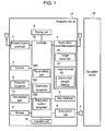
- Fig. 1 shows a navigation device in accordance with the exemplary embodiment of the present invention.
- Figs. 2 and 3 show first and second flowcharts representing the operation of the navigation device, respectively.
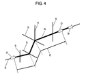
- Fig. 4 shows a schematic diagram illustrating the operation of the navigation device.
- navigation device 13 of the exemplary embodiment of the present invention includes: present location positioner 1 that has a global positioning system (GPS) receiver for positioning a present location, and self-contained navigation unit; and camera 2, i.e. an imaging means for imaging visual scenes ahead or around the present location; and map database 5 having stored map data.
- GPS global positioning system
- navigation device 13 of the exemplary embodiment includes: radio wave transmitter/receiver 4 for transmitting and receiving various kinds of data including image data; character recognizer 3 for recognizing characters, when the received image includes character data; voice output part 6 for outputting a various kinds of data as voice signals; and speaker 7 connected to voice output part 6.
- radio wave transmitter/receiver 4 has image transmitter 41 for transmitting images, and image receiver 42 for receiving images.
- navigation device 13 of the exemplary embodiment includes: display part 8 for displaying various kinds of data, such as a present location, map data, order, and command in a corresponding manner thereto; operation part 9 for inputting various kinds of orders, commands, and data items; and controller 10 for setting a route to a destination, designating a location of which image data is desired, and controlling each of these parts.
- display part 8 for displaying various kinds of data, such as a present location, map data, order, and command in a corresponding manner thereto
- operation part 9 for inputting various kinds of orders, commands, and data items
- controller 10 for setting a route to a destination, designating a location of which image data is desired, and controlling each of these parts.
- controller 10 includes: destination recognizer 101 having a function of recognizing the destination supplied from operation part 9; route setting part 102 having a function of setting a route to the destination according to a route searching order from operation part 9; and designated location recognizer 103 having a function of recognizing a location of which image data is desired and designated by operation part 9.
- navigation device 13 of the exemplary embodiment is described in detail.
- Present location positioner 1 including a GPS receiver and self-contained navigation unit, positions the present location.
- the positioned present location is displayed on display part 8, under control of controller 10, together with map data accumulated in map database 5.
- destination recognizer 101 of controller 10 recognizes the supplied destination. Then, a route from the present location to the destination is searched under control of route setting part 102 of controller 10, using map database 5. The searched route from the present location to the destination is shown on the map displayed on display part 8 with thicker lines or lines of different colors, for example, according to the setting.
- camera 2 is installed, facing to the front of the vehicle, for example, to image the place ahead of the vehicle. Therefore, camera 2 images the front of the vehicle.
- the image taken by camera 2 is transmitted to the outside of the vehicle together with data on the present location and running direction positioned by present location positioner 1 via image transmitter 41.
- image transmitter 41 it is possible to provide a storage for storing the images and data to be transmitted the outside.
- data on the present location and running direction of the vehicle is transmitted to the outside from navigation device 13 of the running vehicle together with the image data ahead thereof.
- the destination supplied is recognized by destination recognizer 101 of controller 10, and the route from the present location to the destination is searched under control of route setting part 102 of controller 10, using map database 5.
- the route from the present location to the destination is displayed on display part 8.
- the navigation device can receive, from preceding another vehicle, an image taken at the specific distance, and display the image taken thereby on display part 8.
- destination recognizer 101 of controller 10 recognizes the supplied destination, route setting part 102 searches the route from the present location to the destination using map database 5 (S303). Then, the result is shown on the map displayed on display part 8, using thicker lines, or lines of different colors (S304), for example.
- control returns to step S304, and the display part continues to display the route from the present location to the destination.
- the place at the specific distance from the present location is calculated under control of designated location recognizer 103 of controller 10 (S307) in the searched route.
- image receiver 42 of radio wave transmitter/receiver 4 receives an image of another vehicle that is running in the same direction in the searched route and has location data calculated by designated location recognizer 103, among the image data that is transmitted to the outside from navigation devices of running vehicles and has data on locations and running directions of the vehicles (S308), and the image is displayed on display part 8 (S309).
- route R searched is shown by a line thicker than other routes S.
- the navigator device When the user operates the navigator device to receive and display the image of the place at a specific distance, and inputs specific distance C, position D at specific distance C from present location A is calculated under control of designated location recognizer 103 of controller 10. Then, image receiver 42 of radio wave transmitter/receiver 4 receives an image having data on position D. At this time, the image receiver receives data not only on the location but also on the direction and an image of a scene in direction B toward the destination.
- entry of a specific distance allows reception of an image ahead of the place at the specific distance from the present location and display of the image together with data on the location and direction, on display part 8.
- the character data is cut out from the image and recognized as characters by character recognizer 3 (S311).
- the character data recognized by character recognizer 3 is supplied to voice output part 6 for output from speaker 7 by voice. Therefore, for example, the place name shown under a traffic light is read out by voice, so that the driver can accurately know the name of the place at the specific distance from the present location beforehand.
- the navigation device includes storage 11 having stored data on the place names and information, and data readout part 12 for reading data from storage 11.
- This structure allows the navigation device to read out the data corresponding to specific character data stored in storage 11 that matches the character data recognized by character recognizer 3, display the readout data on display 8 by image, and output the data through speaker 7 via voice output part 6.
- storage 11 has stored music data and image data in addition to such information data, not only voice information but also music and image corresponding to the recognized characters can be provided through speaker 7 or on display part 8.
- the navigation device receives image data including location data near the calculated location data in the same direction, from another vehicle, displays the data, and completes operation.
- the specific distance is preset to a certain distance, such as a certain value of meters and kilometers.
- this distance can have a specific distance range. In other words, it is possible not to simply specify a certain value of meters or kilometers ahead, but to specify a distance range from a certain value of meters to another value of meters, for example.
- This setting makes the navigation device more convenient because the device can receive images from any one of navigation devices existing in the distance range.
- the navigation device is more convenient because the device can receive an arbitrary image in an arbitrarily set range.
- the device can receive different images from a plurality of navigation devices at a time and cannot display the images on display part 8 properly in some cases.
- electric field strength detector 43 capable of receiving the image having the largest electric field is provided in image receiver 42, so that the navigation device can receive an image having the largest electric field strength only.
- the location is calculated according to the location data received at that time to provide the distance from the present location, under control of controller 10. The distance is given to the driver on display part 8 or through speaker 7, as a certain value of meters or kilometers ahead of the vehicle.
- This structure allows precise reception of an image of the place at a certain distance from the present location and proper display of the image on display part 8.
- the images to be taken by camera 2 can be moving images and sill images. Still images can be taken at regular periods or distances, and transmitted upon being taken.
- radio transmitter/receiver 4 need not be brought into the transmission state necessarily while the images are not taken. For this reason, radio transmitter/receiver 4 can be structured so as to transmit and receive data alternately. Of course, even in this case, radio transmitter/receiver 4 capable of transmission and reception at a time can be used in a similar manner to those always transmitting moving images.
- each navigation device 13 transmits an image taken by the camera thereof and directly receives an image from navigation device 14 at a specific distance ahead of the present location of navigation device 13.
- a center device i.e. preceding another vehicle, between both navigation devices.
- a center device When a center device is disposed among the navigation devices, communication between the center device and each navigation device can provide the image of a place at a further distance from the present location in real time.
- the center device can store the past data for a certain period of time.
- the present invention can easily provide an image of the place at a predetermined distance ahead of the present location.
- the present invention gives feeling of security to the driver thereof.
- a present location positioning means can position a present location
- a route setting means can set a route
- a location designating means designates a location.
- an image receiving means can receive an image taken by another device in a designated location in the route
- a display means can display the image.
- the navigation device has an advantage of providing the precise visual scene of the designated location in the route along which the driver is going to drive beforehand.
- the present invention is useful as a navigation device having functions of receiving and displaying image data.
Abstract
Present location data positioned by present location positioner (1) and an image of the scene of the present location taken by camera (2) are transmitted to the outside via radio wave receiver/transmitter (4). On the other hand, a route from the present location to a destination is set by entry of the destination, and the location a certain value of kilometers ahead of the present location is designated by operation part (9) in the set route. Then, image data including the data on the designated location is received via radio wave receiver/transmitter (4), and the received image is displayed on display part (8). Thus, the visual scene of the location designated in the route to the destination can be received and displayed beforehand.
Description
- The present system relates to a navigation device that has functions capable of receiving and displaying image data.
- A known conventional navigation device for receiving surrounding images taken by a camera can automatically provide the situations of a portion hidden behind oncoming cars, based on the images taken by the camera installed in another vehicle. When a vehicle attempts to turn to the right at an intersection where oncoming cars run, there is a strong possibility that the vehicle collides with a motorcycle hidden behind the oncoming cars invisible from the vehicle.
- In another case, when a vehicle runs after a large truck and encounters an intersection or a traffic light, the traffic light is often invisible because it is blocked out by the large truck. Also known is a navigation device for receiving the image of the situations ahead of the traffic light taken from the truck in a similar manner.
- Further, also known in
Japanese Patent Unexamined Publication No. 2003-6797 - However, for the conventional navigation device, which informs a vehicle of situations in real time to enable the user of the vehicle to see a hidden motorcycle or traffic light easily, the images can be exchanged only between the member vehicles.
- Therefore, an arbitrary running vehicle cannot view the images taken by any other vehicle running in the route to the destination.
- To address the above conventional problem, the present invention aims to provide a navigation device capable of receiving an image in any vehicle that is taken by another preceding vehicle in the route to the destination.
- In accordance with one aspect of the present invention, there is provided a navigation device including: a present location positioning means for positioning a present location; a route setting means for inputting a destination and setting a route from the present location positioned by the present location positioning means to the destination; a location designating means for designating a predetermined location in the route from the present location to the destination set by the route setting means; an image receiving means for receiving image data having the location data designated by the location designating means, from preceding another vehicle; and a display means for displaying the image received by the image receiving means.
- With this structure, the present location positioning means can position a present location, the route setting means can set a route, and the location designating means designates a location. Therefore, the image receiving means can receive an image taken at a designated location in the route, from preceding another vehicle, and the display means can display the image. Thereby, a driver of the vehicle can recognize the precise visual scene of the designated location in the route along which the driver is going to drive.
- In accordance with another aspect of the present invention, there is provided a navigation device in which the location designated by the location designating means includes: a distance location indicated by a distance from the present location; and a distance range ahead of the distance location.
- With this structure, even when no vehicles exist at a precise distance indicated by a certain value of meters ahead but a vehicle exists within the distance range, an image from the vehicle can be received. This structure can provide less possibility of receiving no images.
- In accordance with another aspect of the present invention, there is provided a navigation device in which both distance location and distance range can arbitrarily be set.
- This structure can arbitrarily set both distance location and distance range, and provide images in an arbitrary location and an arbitrary distance range
- In accordance with another aspect of the present invention, there is provided a navigation device in which an image receiving means receives an image having the largest electric field strength among those having location data matching the distance location and distance range from the present location.
- With this structure, even when the distance location and distance range are set arbitrarily, an image having the largest electric field strength can be received among those, and thus a clear image can be obtained.
- In accordance with another aspect of the present invention, there is provided a navigation device in which preceding another vehicle is replaced with a center device, and the image data transmitted from the center device includes an image that is taken by an imaging means for taking the background of the present location of another navigation device and transmitted together with the data on the present location thereof.
- This structure can provide a vivid image at a further distance via the center device, i.e. preceding another vehicle.
- In accordance with another aspect of the present invention, there is provided a navigation device further including: a character recognizing means for detecting and recognizing character data when the image data received by the image receiving means includes character data; and a voice output means for synthesizing and outputting character data recognized by the character data recognizing means, by voice.
- With this structure, when the received image includes characters, such as a guideboard and place name, such data is supplied by voice. Thus, the driver can recognize that such a signboard and guide sign of a place name or direction beforehand, and drive the vehicle in a more emotionally and mentally relaxed manner.
- In accordance with another aspect of the present invention, there is provided a navigation device further including: a character data recognizing means for detecting and recognizing character data when the image data received by the image receiving means includes the character data; a storage means having stored data including at least predetermined one of music, image, and information according to the specific character data; an data readout means for searching the storage means based on the character recognized by the character recognizing means and reading out data corresponding to the specific character data stored in the storage means that matches the character data recognized by the character data recognizing means; and a display means for displaying, by voice or image, the data read out by the data readout means.
- With this structure, when the received image includes character data, the navigation device recognizes the data, searches specific character data in the storage means based on the recognized character data, and outputs data, such as music, image, and information, corresponding to the specific data stored in the storage means. For example, the navigation device recognizes characters "Tokyo Tower" and specific character data "Tokyo Tower", information on the Tokyo Tower corresponding to the character data can be supplied.
- In accordance with another aspect of the present invention, there is provided a navigation device further including: an imaging means for imaging the visual scene of the present location; and an image transmitting means for transmitting the image taken by the imaging means together with the present location data positioned by the present location positioning means.
- This structure can provide image data having present location data effective to another navigation device.
- As described above, the present invention includes: a present location positioning means for positioning a present location; a route setting means for inputting a destination and setting a route from the present location to the destination; a location designating means for designating a predetermined location from the present location in the route from the present location to the destination set by the route setting means; an image receiving means for receiving image data having the location data designated by the location designating means, from preceding another vehicle; and a display means for displaying the image received by the image receiving means. With this structure, the present location positioning means can position a present location, the route setting means can set a route, and the location designating means designates a location. Thus, the image receiving means can receive an image taken in a designated location in the route, from preceding another vehicle, and the display means can display the image. This structure can provide a navigation device that has an advantage of allowing a driver of the vehicle to recognize the visual scene of the designated location in the route along which the driver is going to drive.
-
- Fig. 1 is a schematic block diagram of a navigation device in accordance with an exemplary embodiment of the present invention.
- Fig. 2 is a first flowchart showing the operation of the navigation device in accordance with the exemplary embodiment of the present invention.
- Fig. 3 is a second flowchart showing the operation of the navigation device in accordance with the exemplary embodiment of the present invention.
- Fig. 4 is a schematic diagram illustrating the operation of the navigation device in accordance with the exemplary embodiment of the present invention.
- The exemplary embodiment of the present invention is hereinafter described with reference to the accompanying drawings.
- Fig. 1 shows a navigation device in accordance with the exemplary embodiment of the present invention. Figs. 2 and 3 show first and second flowcharts representing the operation of the navigation device, respectively. Fig. 4 shows a schematic diagram illustrating the operation of the navigation device.
- As shown in Fig. 1,
navigation device 13 of the exemplary embodiment of the present invention includes:present location positioner 1 that has a global positioning system (GPS) receiver for positioning a present location, and self-contained navigation unit; andcamera 2, i.e. an imaging means for imaging visual scenes ahead or around the present location; andmap database 5 having stored map data. - Further,
navigation device 13 of the exemplary embodiment includes: radio wave transmitter/receiver 4 for transmitting and receiving various kinds of data including image data;character recognizer 3 for recognizing characters, when the received image includes character data;voice output part 6 for outputting a various kinds of data as voice signals; andspeaker 7 connected tovoice output part 6. - In other words, radio wave transmitter/
receiver 4 hasimage transmitter 41 for transmitting images, andimage receiver 42 for receiving images. - Further,
navigation device 13 of the exemplary embodiment includes: displaypart 8 for displaying various kinds of data, such as a present location, map data, order, and command in a corresponding manner thereto;operation part 9 for inputting various kinds of orders, commands, and data items; andcontroller 10 for setting a route to a destination, designating a location of which image data is desired, and controlling each of these parts. - In other words,
controller 10 includes:destination recognizer 101 having a function of recognizing the destination supplied fromoperation part 9;route setting part 102 having a function of setting a route to the destination according to a route searching order fromoperation part 9; and designatedlocation recognizer 103 having a function of recognizing a location of which image data is desired and designated byoperation part 9. - Next, the operation of
navigation device 13 of the exemplary embodiment is described in detail. -
Present location positioner 1, including a GPS receiver and self-contained navigation unit, positions the present location. The positioned present location is displayed ondisplay part 8, under control ofcontroller 10, together with map data accumulated inmap database 5. - When a destination is supplied using
operation part 9 to search a route to the destination,destination recognizer 101 ofcontroller 10 recognizes the supplied destination. Then, a route from the present location to the destination is searched under control ofroute setting part 102 ofcontroller 10, usingmap database 5. The searched route from the present location to the destination is shown on the map displayed ondisplay part 8 with thicker lines or lines of different colors, for example, according to the setting. - On the other hand,
camera 2 is installed, facing to the front of the vehicle, for example, to image the place ahead of the vehicle. Therefore,camera 2 images the front of the vehicle. The image taken bycamera 2 is transmitted to the outside of the vehicle together with data on the present location and running direction positioned bypresent location positioner 1 viaimage transmitter 41. Of course, it is possible to provide a storage for storing the images and data to be transmitted the outside. - First, the above operation is described, using the flowchart of Fig. 2. When a present location is positioned by present location positioner 1 (S201), the positioned present location is displayed on
display part 8 together with map data (S202). Then, when the front of the vehicle is imaged by camera 2 (S203), the image taken is transmitted to the outside together with data on the present location positioned bypresent location 1 and the running direction, viaimage transmitter 41 of radio wave transmitter/receiver 41 (S204). - As described above, data on the present location and running direction of the vehicle is transmitted to the outside from
navigation device 13 of the running vehicle together with the image data ahead thereof. - Next, for the exemplary embodiment, as described above, when a destination is supplied using
operation part 8 to search a route, the destination supplied is recognized bydestination recognizer 101 ofcontroller 10, and the route from the present location to the destination is searched under control ofroute setting part 102 ofcontroller 10, usingmap database 5. The route from the present location to the destination is displayed ondisplay part 8. - When the user attempts to display the image at a specific distance from the present location, the navigation device can receive, from preceding another vehicle, an image taken at the specific distance, and display the image taken thereby on
display part 8. - A detailed description is provided of this point with reference to Figs. 3 and 4.
- When a destination is supplied using operation part 9 (S301) to search a route (S302),
destination recognizer 101 ofcontroller 10 recognizes the supplied destination,route setting part 102 searches the route from the present location to the destination using map database 5 (S303). Then, the result is shown on the map displayed ondisplay part 8, using thicker lines, or lines of different colors (S304), for example. - When the user operates
operation part 9 to receive and display an image from the place at a specific distance from the present location (Y in S305), a screen for inputting the specific distance appears ondisplay part 8. - If the image of the place at a specific distance from the present location is not received (N in S305), control returns to step S304, and the display part continues to display the route from the present location to the destination.
- When the user operates the operation part to receive and display the image of the place at a specific distance from the present location in Y in step S305, and arbitrarily inputs the specific distance in the screen for inputting the specific distance (S306), the place at the specific distance from the present location is calculated under control of designated
location recognizer 103 of controller 10 (S307) in the searched route. - Thereafter, as described with reference to the flowchart of Fig. 2,
image receiver 42 of radio wave transmitter/receiver 4 receives an image of another vehicle that is running in the same direction in the searched route and has location data calculated by designatedlocation recognizer 103, among the image data that is transmitted to the outside from navigation devices of running vehicles and has data on locations and running directions of the vehicles (S308), and the image is displayed on display part 8 (S309). - For example, when the present location of a vehicle is A and the destination thereof is in B direction, as shown in Fig. 4, the route from present location A to the destination is searched, and route R searched is shown by a line thicker than other routes S. When the user operates the navigator device to receive and display the image of the place at a specific distance, and inputs specific distance C, position D at specific distance C from present location A is calculated under control of designated
location recognizer 103 ofcontroller 10. Then,image receiver 42 of radio wave transmitter/receiver 4 receives an image having data on position D. At this time, the image receiver receives data not only on the location but also on the direction and an image of a scene in direction B toward the destination. - Therefore, in accordance with the exemplary embodiment, entry of a specific distance allows reception of an image ahead of the place at the specific distance from the present location and display of the image together with data on the location and direction, on
display part 8. - When the received image includes specific character data, such as a place name and information (Y in S310), the character data is cut out from the image and recognized as characters by character recognizer 3 (S311). The character data recognized by
character recognizer 3 is supplied to voiceoutput part 6 for output fromspeaker 7 by voice. Therefore, for example, the place name shown under a traffic light is read out by voice, so that the driver can accurately know the name of the place at the specific distance from the present location beforehand. - Further, the navigation device includes
storage 11 having stored data on the place names and information, and data readoutpart 12 for reading data fromstorage 11. This structure allows the navigation device to read out the data corresponding to specific character data stored instorage 11 that matches the character data recognized bycharacter recognizer 3, display the readout data ondisplay 8 by image, and output the data throughspeaker 7 viavoice output part 6. - For example, when characters "Tokyo Tower" are recognized from image signals received by
image receiver 42 andstorage 11 includes specific character data "Tokyo Tower", the information on Tokyo Tower corresponding to the character data is supplied. - If
storage 11 has stored music data and image data in addition to such information data, not only voice information but also music and image corresponding to the recognized characters can be provided throughspeaker 7 or ondisplay part 8. - When the image received by
image receiver 41 does not include specific character data, such as a place name and guide sign (N in S310), the navigation device receives image data including location data near the calculated location data in the same direction, from another vehicle, displays the data, and completes operation. - In the exemplary embodiment, the specific distance is preset to a certain distance, such as a certain value of meters and kilometers. However, this distance can have a specific distance range. In other words, it is possible not to simply specify a certain value of meters or kilometers ahead, but to specify a distance range from a certain value of meters to another value of meters, for example. This setting makes the navigation device more convenient because the device can receive images from any one of navigation devices existing in the distance range.
- Additionally, when any distance range can be set in this case, the navigation device is more convenient because the device can receive an arbitrary image in an arbitrarily set range.
- When the navigation device has such a distance range, the device can receive different images from a plurality of navigation devices at a time and cannot display the images on
display part 8 properly in some cases. However, in this case, electricfield strength detector 43 capable of receiving the image having the largest electric field is provided inimage receiver 42, so that the navigation device can receive an image having the largest electric field strength only. Then, the location is calculated according to the location data received at that time to provide the distance from the present location, under control ofcontroller 10. The distance is given to the driver ondisplay part 8 or throughspeaker 7, as a certain value of meters or kilometers ahead of the vehicle. - This structure allows precise reception of an image of the place at a certain distance from the present location and proper display of the image on
display part 8. - Though not having specifically referred to in the description, the images to be taken by
camera 2 can be moving images and sill images. Still images can be taken at regular periods or distances, and transmitted upon being taken. - In this case, radio transmitter/
receiver 4 need not be brought into the transmission state necessarily while the images are not taken. For this reason, radio transmitter/receiver 4 can be structured so as to transmit and receive data alternately. Of course, even in this case, radio transmitter/receiver 4 capable of transmission and reception at a time can be used in a similar manner to those always transmitting moving images. - This exemplary embodiment is structured so that each
navigation device 13 transmits an image taken by the camera thereof and directly receives an image fromnavigation device 14 at a specific distance ahead of the present location ofnavigation device 13. Of course, it is possible to dispose a center device, i.e. preceding another vehicle, between both navigation devices. - When a center device is disposed among the navigation devices, communication between the center device and each navigation device can provide the image of a place at a further distance from the present location in real time. The center device can store the past data for a certain period of time.
- As described above, the present invention can easily provide an image of the place at a predetermined distance ahead of the present location. Thus, when incorporated into a vehicle, the present invention gives feeling of security to the driver thereof.
- In a navigation device of the present invention, a present location positioning means can position a present location, a route setting means can set a route, and a location designating means designates a location. Thus, an image receiving means can receive an image taken by another device in a designated location in the route, and a display means can display the image. Thereby, the navigation device has an advantage of providing the precise visual scene of the designated location in the route along which the driver is going to drive beforehand. The present invention is useful as a navigation device having functions of receiving and displaying image data.
Claims (8)
- A navigation device including:a present location positioning means for positioning a present location;a route setting means for inputting a designation and setting a route from the present location positioned by the present location positioning means to the destination;a location designating means for designating a predetermined location from the present location in the route from the present location to the destination set by the route setting means;an image receiving means for receiving image data having the location data designated by the location designating means, from preceding another vehicle; anda display means for displaying an image received by the image receiving means.
- The navigation device of claim 1, wherein the distance designated by the location designating means includes:a distance location indicated by a distance from the present location; anda distance range ahead of the distance location.
- The navigation device of claim 2, wherein both distance location and distance range can arbitrarily be set.
- The navigation device of claim 2, wherein the image receiving means receives an image having a largest electric field strength among images having location data matching the distance location and distance range from the present location.
- The navigation device of claim 1, wherein preceding another vehicle is a center device, and image data transmitted from the center device includes an image that is taken by an imaging means for taking a background of a present location of another navigation device and transmitted together with data on the present location thereof.
- The navigation device of claim 1 including:a character data recognizing means for detecting and recognizing character data, when the image data received by the image receiving means includes the character data; anda voice output means for synthesizing and outputting character data recognized by the character data recognizing means, by voice.
- The navigation device of claim 1 including:a character data recognizing means for detecting and recognizing character data, when the image data received by the image receiving means includes the character data;a storage means having stored data including at least predetermined one of music, image, and information corresponding to specific character data;a data readout means for searching the storage means based on the character data recognized by the character recognizing means, and reading out data corresponding to the specific character data stored in the storage means that matches the character data recognized by the character data recognizing means; anda display means for displaying the data read out by the data readout means, by voice and image.
- A navigation device of claim 1 including:an imaging means for imaging a visual scene of the present location; andan image transmitter for transmitting the image taken by the imaging means together with the present location data position by the present location positioning means.
Applications Claiming Priority (2)
| Application Number | Priority Date | Filing Date | Title |
|---|---|---|---|
| JP2003407250 | 2003-12-05 | ||
| PCT/JP2004/018099 WO2005054783A1 (en) | 2003-12-05 | 2004-11-30 | Navigation device |
Publications (1)
| Publication Number | Publication Date |
|---|---|
| EP1710537A1 true EP1710537A1 (en) | 2006-10-11 |
Family
ID=34650303
Family Applications (1)
| Application Number | Title | Priority Date | Filing Date |
|---|---|---|---|
| EP04799949A Withdrawn EP1710537A1 (en) | 2003-12-05 | 2004-11-30 | Navigation device |
Country Status (5)
| Country | Link |
|---|---|
| US (1) | US20070143009A1 (en) |
| EP (1) | EP1710537A1 (en) |
| JP (1) | JPWO2005054783A1 (en) |
| CN (1) | CN1890533A (en) |
| WO (1) | WO2005054783A1 (en) |
Families Citing this family (14)
| Publication number | Priority date | Publication date | Assignee | Title |
|---|---|---|---|---|
| US7474959B2 (en) * | 2004-10-08 | 2009-01-06 | Scenera Technologies, Llc | Method for providing recommendations using image, location data, and annotations |
| DE102004049870A1 (en) * | 2004-10-13 | 2006-04-20 | Robert Bosch Gmbh | Method and device for improving the visibility of drivers of motor vehicles |
| JP2007089017A (en) * | 2005-09-26 | 2007-04-05 | Pioneer Electronic Corp | Communication terminal, data transmission method, data reception method, data transmission program, data reception program and recording medium |
| JP4935145B2 (en) * | 2006-03-29 | 2012-05-23 | 株式会社デンソー | Car navigation system |
| US7945576B2 (en) * | 2007-05-29 | 2011-05-17 | Microsoft Corporation | Location recognition using informative feature vocabulary trees |
| CN102012230A (en) * | 2010-08-27 | 2011-04-13 | 杭州妙影微电子有限公司 | Road live view navigation method |
| ITTO20110686A1 (en) * | 2011-07-28 | 2013-01-29 | Sisvel Technology Srl | METHOD TO GUARANTEE THE CONTINUITY OF SERVICE OF A PERSONAL NAVIGATION AND RELATIVE DEVICE |
| CN104422439B (en) * | 2013-08-21 | 2017-12-19 | 希姆通信息技术(上海)有限公司 | Air navigation aid, device, server, navigation system and its application method |
| JP2016138816A (en) * | 2015-01-28 | 2016-08-04 | アルパイン株式会社 | Navigation device and computer program |
| JP6540485B2 (en) * | 2015-12-07 | 2019-07-10 | 株式会社デンソー | Route change apparatus and route change system |
| DE102016203725A1 (en) * | 2016-03-08 | 2017-09-14 | Robert Bosch Gmbh | Information system for a motor vehicle |
| CN106845470B (en) * | 2017-02-20 | 2020-12-11 | 百度在线网络技术(北京)有限公司 | Map data acquisition method and device |
| CN107677289B (en) * | 2017-09-30 | 2020-04-28 | 百度在线网络技术(北京)有限公司 | Information processing method and device and motor vehicle |
| JP7236677B2 (en) * | 2019-12-25 | 2023-03-10 | パナソニックIpマネジメント株式会社 | Communication device and communication method |
Family Cites Families (5)
| Publication number | Priority date | Publication date | Assignee | Title |
|---|---|---|---|---|
| JPH05174294A (en) * | 1991-12-24 | 1993-07-13 | Sharp Corp | Road-sigh reader |
| JPH11298813A (en) * | 1998-04-15 | 1999-10-29 | Sony Corp | Television receiver |
| JP3969852B2 (en) * | 1998-06-29 | 2007-09-05 | キヤノン株式会社 | Mobile communication system and communication device |
| JP4505958B2 (en) * | 2000-07-12 | 2010-07-21 | 株式会社エクォス・リサーチ | Information transmission method and system |
| JP2003067407A (en) * | 2001-08-24 | 2003-03-07 | Clarion Co Ltd | Vehicle-mounted information retrieving device and information retrieving method |
-
2004
- 2004-11-30 CN CNA2004800358444A patent/CN1890533A/en active Pending
- 2004-11-30 WO PCT/JP2004/018099 patent/WO2005054783A1/en not_active Application Discontinuation
- 2004-11-30 JP JP2005516009A patent/JPWO2005054783A1/en not_active Withdrawn
- 2004-11-30 US US10/581,896 patent/US20070143009A1/en not_active Abandoned
- 2004-11-30 EP EP04799949A patent/EP1710537A1/en not_active Withdrawn
Non-Patent Citations (1)
| Title |
|---|
| See references of WO2005054783A1 * |
Also Published As
| Publication number | Publication date |
|---|---|
| CN1890533A (en) | 2007-01-03 |
| WO2005054783A1 (en) | 2005-06-16 |
| JPWO2005054783A1 (en) | 2007-06-28 |
| US20070143009A1 (en) | 2007-06-21 |
Similar Documents
| Publication | Publication Date | Title |
|---|---|---|
| EP1439373B1 (en) | Device and method for providing traffic information in navigation system | |
| JP4293917B2 (en) | Navigation device and intersection guide method | |
| US7630830B2 (en) | Navigation apparatus, driving direction guidance method, and navigation system | |
| US7386437B2 (en) | System for providing translated information to a driver of a vehicle | |
| US7650235B2 (en) | Telematics system using image data and method for directing a route by using the same | |
| US6963799B2 (en) | Road traffic information processing apparatus, road traffic information processing method, computer program, and information record medium | |
| EP1710537A1 (en) | Navigation device | |
| EP1484580B1 (en) | Apparatus and method for providing travel route in navigation system | |
| CN101578501A (en) | Navigation device and method | |
| US20060142939A1 (en) | System and method for navigation | |
| US8548737B2 (en) | Navigation apparatus | |
| KR20070031641A (en) | Navigation system using radio frequency identification system and method for displaying construction site road | |
| CN101903927A (en) | Navigation device and method for reporting traffic incidents by the driver | |
| JP4489619B2 (en) | Navigation device and method for guiding relative position of own vehicle | |
| KR19990030808A (en) | Method and device for providing traffic information using the Internet | |
| JP2004294427A (en) | On-vehicle device | |
| JP3259553B2 (en) | Search route receiving device and search route transmitting device | |
| KR20090051340A (en) | Method for finding path and navigation using the same | |
| EP4184118A1 (en) | Method of determining and communicating a travel route of a user of a road vehicle | |
| JP2000055677A (en) | Communication system between vehicles | |
| KR20040025150A (en) | Route guide method in car navigation system | |
| JPH06174481A (en) | Bar code display body, and information output device, navigation device, map information retrieval system utilizing it | |
| JP2005128603A (en) | Object recognition device and method | |
| US20030046001A1 (en) | Route guidance system, method, and program for automotive vehicle | |
| JP2003232642A (en) | Specified distance notifying device and navigation device |
Legal Events
| Date | Code | Title | Description |
|---|---|---|---|
| PUAI | Public reference made under article 153(3) epc to a published international application that has entered the european phase |
Free format text: ORIGINAL CODE: 0009012 |
|
| 17P | Request for examination filed |
Effective date: 20060531 |
|
| AK | Designated contracting states |
Kind code of ref document: A1 Designated state(s): DE FR GB |
|
| DAX | Request for extension of the european patent (deleted) | ||
| RBV | Designated contracting states (corrected) |
Designated state(s): DE FR GB |
|
| STAA | Information on the status of an ep patent application or granted ep patent |
Free format text: STATUS: THE APPLICATION HAS BEEN WITHDRAWN |
|
| 18W | Application withdrawn |
Effective date: 20080714 |