EP1593938A1 - Method for indicating a route to a destination and navigation system therefor - Google Patents
Method for indicating a route to a destination and navigation system therefor Download PDFInfo
- Publication number
- EP1593938A1 EP1593938A1 EP04010565A EP04010565A EP1593938A1 EP 1593938 A1 EP1593938 A1 EP 1593938A1 EP 04010565 A EP04010565 A EP 04010565A EP 04010565 A EP04010565 A EP 04010565A EP 1593938 A1 EP1593938 A1 EP 1593938A1
- Authority
- EP
- European Patent Office
- Prior art keywords
- destination
- route
- parking position
- vehicle
- final parking
- Prior art date
- Legal status (The legal status is an assumption and is not a legal conclusion. Google has not performed a legal analysis and makes no representation as to the accuracy of the status listed.)
- Ceased
Links
- 238000000034 method Methods 0.000 title claims description 12
- 238000001514 detection method Methods 0.000 description 5
- 230000001413 cellular effect Effects 0.000 description 2
- 230000037361 pathway Effects 0.000 description 2
- 238000004364 calculation method Methods 0.000 description 1
- 230000001419 dependent effect Effects 0.000 description 1
- 239000000446 fuel Substances 0.000 description 1
- 230000029305 taxis Effects 0.000 description 1
Images


Classifications
-
- G—PHYSICS
- G01—MEASURING; TESTING
- G01C—MEASURING DISTANCES, LEVELS OR BEARINGS; SURVEYING; NAVIGATION; GYROSCOPIC INSTRUMENTS; PHOTOGRAMMETRY OR VIDEOGRAMMETRY
- G01C21/00—Navigation; Navigational instruments not provided for in groups G01C1/00 - G01C19/00
- G01C21/26—Navigation; Navigational instruments not provided for in groups G01C1/00 - G01C19/00 specially adapted for navigation in a road network
- G01C21/34—Route searching; Route guidance
- G01C21/3407—Route searching; Route guidance specially adapted for specific applications
- G01C21/3423—Multimodal routing
-
- G—PHYSICS
- G01—MEASURING; TESTING
- G01C—MEASURING DISTANCES, LEVELS OR BEARINGS; SURVEYING; NAVIGATION; GYROSCOPIC INSTRUMENTS; PHOTOGRAMMETRY OR VIDEOGRAMMETRY
- G01C21/00—Navigation; Navigational instruments not provided for in groups G01C1/00 - G01C19/00
- G01C21/26—Navigation; Navigational instruments not provided for in groups G01C1/00 - G01C19/00 specially adapted for navigation in a road network
- G01C21/34—Route searching; Route guidance
- G01C21/36—Input/output arrangements for on-board computers
- G01C21/3679—Retrieval, searching and output of POI information, e.g. hotels, restaurants, shops, filling stations, parking facilities
- G01C21/3685—Retrieval, searching and output of POI information, e.g. hotels, restaurants, shops, filling stations, parking facilities the POI's being parking facilities
-
- G—PHYSICS
- G01—MEASURING; TESTING
- G01C—MEASURING DISTANCES, LEVELS OR BEARINGS; SURVEYING; NAVIGATION; GYROSCOPIC INSTRUMENTS; PHOTOGRAMMETRY OR VIDEOGRAMMETRY
- G01C21/00—Navigation; Navigational instruments not provided for in groups G01C1/00 - G01C19/00
- G01C21/26—Navigation; Navigational instruments not provided for in groups G01C1/00 - G01C19/00 specially adapted for navigation in a road network
- G01C21/34—Route searching; Route guidance
- G01C21/36—Input/output arrangements for on-board computers
- G01C21/3688—Systems comprising multiple parts or multiple output devices (not client-server), e.g. detachable faceplates, key fobs or multiple output screens
-
- G—PHYSICS
- G08—SIGNALLING
- G08G—TRAFFIC CONTROL SYSTEMS
- G08G1/00—Traffic control systems for road vehicles
- G08G1/09—Arrangements for giving variable traffic instructions
- G08G1/0962—Arrangements for giving variable traffic instructions having an indicator mounted inside the vehicle, e.g. giving voice messages
- G08G1/0968—Systems involving transmission of navigation instructions to the vehicle
- G08G1/0969—Systems involving transmission of navigation instructions to the vehicle having a display in the form of a map
Definitions
- the invention relates to a navigation system in a vehicle indicating a route to a predetermined destination and to a method for indicating the route to a predetermined destination.
- the invention relates especially to a navigation system which can be used when the vehicle cannot be parked in the close neighborhood of the destination.
- a current position of the vehicle is detected together with other data of the operating state of the vehicle, and these data are used for guiding the driver of the vehicle to a predetermined destination.
- the parking possibilities may be restricted so that it is nearly impossible to park the vehicle near the destination the user of the vehicle wants to reach.
- large parking grounds exist which are situated distances away from the destination itself.
- the user of a vehicle has finally arrived at the predetermined destination, but after having looked for a parking possibility the final parking position is situated quite a distance away from the actual destination itself.
- the navigation system in a vehicle comprises means for detecting the current position of the vehicle.
- the detection of the position may be based on data received from a satellite system such as GPS.
- the position of the vehicle can be detected using data of the operating state of the vehicle, i . e ., direction changes, speed, etc.
- any other system for detecting the actual position of the vehicle can be used.
- means for calculating a route to a predetermined destination are provided based on the actual position of the vehicle and based on the destination which is normally input by the driver of the vehicle.
- the route may be calculated using digital map data.
- These digital map data can be stored in the navigation system or can be provided from outside the navigation system using wireless communication systems.
- means are provided for detecting whether the vehicle has reached the final parking position at the destination.
- means are provided for determining a route from the final parking position to the predetermined destination.
- For informing the driver means for outputting indications concerning the route from the final parking position to the predetermined destination are provided.
- the navigation system of the invention determines a route from the final parking position to the destination the user of the vehicle can use when he or she leaves the car and walks to the destination on foot or will reach the destination by any other transportation facilities, as will be described in detail later on.
- the navigation system helps the user of the vehicle to find the destination by outputting indications when the driver needs to walk to the destination, the destination being a restaurant, a theater, a sport arena or any other destination input by the driver of the vehicle or received from other sources outside the vehicle.
- the user of the vehicle navigation system can now find his or her way more easily as he or she is provided with information how to reach the destination from the final parking position.
- the user of the vehicle can decide whether he or she wants to start the vehicle again and try to find another parking position which is closer to the final destination. In this case the navigation system restarts to guide the user of the vehicle to the destination. According to another embodiment, the navigation system could also ask the driver whether the guiding mode should be (re)started again.
- said means for outputting indications indicates the pedestrian route to the destination, the direction to the destination relative to the parked vehicle and/or the time it takes to get there. Furthermore, the distance of path, information describing the route to the destination and/or the straight line to the final destination could be output.
- the navigation system could output that the destination is located 200 meters north of the current parking position and can be reached within three minutes, or: The destination or the main entrance is located on the left side and it takes two minutes to get there. The navigation system may also output the whole route from the parking position to the destination.
- the navigation system may further comprise means for enabling or disabling said means for outputting indications concerning the route from the final parking position to the predetermined destination.
- the final parking position is situated directly next to the predetermined destination there may be no need to give further information indicating the route to the destination itself.
- the user of the navigation system knows the neighborhood of the final parking position very well, so that he or she does not need help to get from the parking position to the destination.
- means are provided which enable or disable the outputting of indications concerning the route from the parking position to the predetermined destination.
- the navigation system further comprises a data base comprising roadmap data.
- the roadmap data consists of vehicle roadmap data and pedestrian roadmap data.
- the roadmap data used in navigation systems nowadays' comprise all the roadmap data necessary to calculate a route to the predetermined destination when a vehicle is used.
- the roadmap data also comprise pedestrian roadmap data which are used for calculating the route from the parking position to the destination. This does not mean that for the pedestrian route to the destination only pedestrian roadmap data are used, but on foot a person can use roads a vehicle can use, but can also use other roads which are closed for vehicles or the used vehicle type, such as pedestrian areas, one way streets, steps, pathways etc.
- the data base may further comprise data such as time tables for public transportations etc., which can be used when used transportation facilities are used on the way from the parking position to the destination.
- the navigation system calculates a route from the final parking position to the predetermined destination which considers the fastest and shortest route for a pedestrian.
- the word "pedestrian” means not necessarily that the person will walk the whole distance.
- the pedestrian route can also comprise sections of a route for which busses, taxis, ferry boats etc. are used.
- said means for enabling or disabling said means for outputting indications concerning the route from the final parking position to the predetermined destination enables or disables the outputting of information in dependence of the route from the parking position to the destination.
- the outputting of indications may be disabled. There are many other criteria for enabling or disabling the output of indications which are described below in more detail.
- the navigation system may output indications concerning the route to the final destination by indicating the indications on a display unit of the navigation system and/or by a voice output using loudspeakers of the navigation system.
- the navigation system further comprises a transmitting/receiving interface which transmits the indications to the mobile information unit, e. g ., a cellular phone or a PDA or any other device which is able to display information or to output information by voice.
- the mobile information unit e. g ., a cellular phone or a PDA or any other device which is able to display information or to output information by voice.
- the navigation system can help to determine whether the route to the destination is "difficult" or not.
- a value describing the complexity of each section of the route can be defined depending on the section of the route.
- the complexity of each route section can depend on different parameters, e.g. the functional road class.
- the functional road class is a parameter describing the importance of a road, large roads with multiple lanes being another class than small pathways. The smaller the road the more difficult it will be to find it. Therefore, the complexity of a route section depends on the respective road class of this section of the route.
- the complexity may further depend on the length of a route section, the number of locations at which a maneuver is necessary to follow the route to the predetermined destination and/or other features like tunnels, serpentines, stairs.
- the value describing the complexity is determined for each section of the pedestrian route and the total complexity over the entire pedestrian route can be determined. If the complexity exceeds a certain threshold value, the output of the pedestrian route is enabled that the user leaving the vehicle is provided with additional information.
- a method for indicating a route to a predetermined destination in a vehicle comprises the following steps: The current position of the vehicle is detected, a route to a predetermined destination is calculated and it is detected whether the vehicle has reached the final parking position at the destination. In a further step, a route is determined from the final parking position to the destination and indications are output concerning the route from the final parking position to the destination.
- the user of the vehicle wants to have the information concerning the route from the parking position to the destination he or she will enable the output of indications. If the user does not want to have any indications he or she will disable the output of indications.
- a pedestrian route from the final parking position to the predetermined destination is determined also considering roads which are closed for vehicles when the route from the parking position to the destination is calculated.
- roads which are closed for vehicles when the route from the parking position to the destination is calculated.
- other means of transportation than the own vehicle can be taken into consideration (shuttle busses, public or private transportation services etc.).
- the output of the route from the final parking position to the predetermined destination is enabled or disabled in dependence of the fact that the destination is located in the same road as the final parking position. If the parking position is located in the same road as the final parking position the output of indications may be disabled as there is no need to get further information.
- the output of information regarding the route may also be enabled when the destination comprises a car park or a parking garage. Sometimes, places such as leisure parks, sport arenas or airports comprise huge car parks or parking garages. When the user of the vehicle has found a parking place in the car park or parking garage he or she might not know anymore where the destination itself is located. In this case, the navigation system of the invention may help by indicating that a certain exit should be used to get to the destination on foot.
- the output of indications could also be enabled or disabled depending on the fact that the destination can be reached within a certain amount of time. If the calculated route from the parking position to the predetermined destination is within walking distance the output may be enabled, in other cases the output may be disabled.
- the output may also be enabled and disabled depending on the fact whether the distance from the parking position to the destination is larger or smaller than a threshold value. If the distance is smaller than a threshold value the output may be disabled as there is no need for further information, or when the distance is larger than a threshold value the output may be disabled as the destination is not within walking distance or could only be reached by using roads which are closed for vehicles such as highways. In this case, however, the navigation system could inform the driver that the destination cannot be reached on foot or the driver can be informed that it takes more than a certain amount of time so that the user of the vehicle should not walk.
- the output of indications could also be enabled or disabled depending on the fact that the destination is located in a pedestrian area. If the destination is situated in a pedestrian area indications may be helpful where to find the destination in the pedestrian area.
- the output may also be enabled or disabled depending on the complexity of the calculated pedestrian route. If the complexity of the pedestrian route exceeds a predetermined threshold value, the output of indications is enabled, otherwise disabled.
- the navigation system may comprise an enable or disable button for enabling or disabling the output of indications. If the user of the vehicle always wants to be informed of the route to the final destination the enabling/ disabling button may be employed in such a way that the indications concerning the route are always output. Furthermore, the button can be configured in such a way that the output is always disabled, so that there are no indications at all.
- the direction of the destination relative to the final parking position is output, e. g ., the destination is situated on the right-hand side.
- the time it takes to get there may be output, e. g ., the destination can be reached within two minutes walking distance.
- the exact pedestrian route to the destination may be output describing the complete route to the destination.
- additional information concerning the pedestrian route to the destination can be output and/or additional information relating to the destination itself could be output.
- the additional information concerning the pedestrian route could comprise the information that for reaching the destination additional transportation possibilities can be used. This information could be: For terminal 4 (destination) please use shuttle bus no. 6. The bus will stop in front of the main exit of the parking garage.
- the system of the invention can output any additional information useful for a pedestrian to get to a certain destination. This information could comprise time tables from public transportation services, etc.
- the vehicle has to be determined, whether the vehicle has reached the predetermined destination.
- the user is informed when he or she has reached the final destination.
- the user could be informed orally by a voice indicating that the destination has been reached or any other similar indications.
- For detecting whether the final parking position has been reached it may be detected whether the engine of the vehicle has been turned off.
- the actual position of the vehicle may be compared to the geographical position of the predetermined destination. If it is determined that the final parking position only differs from the destination by a certain distance and the engine is turned off, it may be detected that the final parking position has been reached.
- the indications concerning the route from the parking position to the destination may be transmitted to a mobile information unit of the user of the vehicle.
- Indications may be output orally or visually in the vehicle itself and may, at the same time, be transmitted to the mobile information unit of the user, so that the user can be informed of the pedestrian route to the destination on his way while he or she is walking.
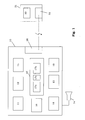
- a navigation system 10 for outputting indications concerning the route from the final parking position to the destination is shown schematically.
- the navigation system 10 comprises a position detection unit 11 for detecting the actual position of the vehicle. Furthermore, a route calculating unit 12 is provided for calculating the route from the actual position to a predetermined destination. The driver of the vehicle can be informed, what route to take by using a display 13 or by using loudspeakers 14 of the navigation system 10.
- the above described units are present in every navigation system and their functioning is well known to the person skilled in the art so that a detailed description of their functioning is omitted.
- the navigation system 10 further comprises a unit 15 for detecting whether the final parking position has been reached.
- a pedestrian route calculation unit 16 is provided for calculating the route from the final parking position to the predetermined destination.
- the navigation system 10 comprises a data base 17 comprising road map data which comprises data 17a which are used for calculating the route to the destination of the vehicle, and comprises roadmap data 17b for calculating a pedestrian route to the predetermined destination.
- road map data which comprises data 17a which are used for calculating the route to the destination of the vehicle
- roadmap data 17b for calculating a pedestrian route to the predetermined destination.
- the data used for calculating a route for a vehicle differ from the data used for calculating a route for a pedestrian.
- the data base 17 comprises data 17c containing line tables for shuttle busses, public transportations, and/or information about locations of entrances in large buildings or sport arenas, or any other information which can be helpful for a pedestrian who wants to reach a certain destination not using the own vehicle, the latter being parked.
- the roadmap data 17a and 17b and 17c need not be two physically separated data. In the embodiment shown they are shown as two independent roadmap data in order to emphasize that for calculating a pedestrian route other roadmap data can be used compared to roadmap data used for calculating a vehicle route.
- a disabling/ enabling unit 18 is provided for disabling or enabling the output of indications concerning the route from the final parking position to the destination.
- a control unit 19 controls the functioning of the navigation system.
- a transmitting/receiving unit 20 is provided for transmitting the indications concerning the route from the final parking position to the destination to a mobile information unit 30.
- This mobile information unit 30 may be a cellular phone or a PDA or any other mobile unit which is able to receive the data from the navigation system 10 via a transmitting/receiving unit 32 and which is able to inform the user of the mobile information unit of the received data, e. g ., via a display 33.
- the control unit may further calculate a value of complexity for the pedestrian route by summing up the complexity values of the different sections of the route. If a certain threshold value is exceeded, the output of indications is enabled or disabled.
- a first step 120 the predetermined destination is entered into the navigation system 10 by using an input unit (not shown) of the navigation system. The destination could also be received via the transmitting/receiving unit 20 receiving data from a web server or from another communication unit.
- step 121 the actual position of the vehicle is calculated using the position detection unit 11 shown in Fig. 1.
- step 122 a route for the vehicle from the actual position to the predetermined destination is calculated and in step 123 the navigation system starts to guide the user of the vehicle by outputting indications what road to take.
- step 124 it is asked whether the navigation is completed or not, i.
- step 125 whether the vehicle has reached the final parking position. This can be done by detecting whether the engine of the vehicle has been turned off. However, any other possibility for detecting whether the vehicle has reached the final parking position can be used, one possibility being the detection whether the position of the vehicle changes or not for a predetermined amount of time in the neighborhood of the final parking position. Another possibility for detecting the final parking position is the detection of the vehicle door position, i.e. whether the door has been opened. Furthermore, it can be detected whether the driver's seat is occupied or not.
- step 124 to ask whether the guidance can be terminated is incorporated as to avoid that the pedestrian route is calculated from a location which is far away from the predetermined destination. With this step it can be avoided that a pedestrian route is calculated when the driver of the vehicle stops at a gas station to take up fuel.
- the system can ask whether the actual position of the vehicle is within the surroundings of the predetermined destination. If the vehicle stops at a position near the predetermined destination and engines are turned off the system can determine that the final parking position has been reached in step 125.
- a pedestrian route is calculated in step 126.
- the pedestrian roadmap data 17b are used and a pedestrian route is calculated also considering one way streets, pedestrian areas, etc.
- indications concerning the route to the predetermined destination are output. In this step 127 the direction of the destination relative to the final parking position, the time it takes to get there, the exact pedestrian route to the destination and any additional information relating to the route or to the destination itself could be output.
- Fig. 3 some steps of Fig. 2 are shown in more detail.
- the pedestrian route is calculated in step 126, it is asked in step 130 whether the outputting of indications is enabled or not.
- the outputting of indications concerning the pedestrian route to the predetermined destination could depend on the following criteria.
- the route is output, if the destination is situated in another road as the detected final parking position, the destination is output when the vehicle parks in a large parking garage comprising different exits, so that the pedestrian route from the parking garage to the destination may be helpful.
- the output may be enabled when the destination can be reached within a certain amount of time, i. e ., is in walking distance.
- the indications concerning the route may be transmitted to the transmitting/receiving unit 20 which transmits the data to the mobile information unit 31 of Fig. 1 (step 131). This mobile information unit can then be used during walking. Additionally, the indications concerning the route are displayed in step 132 on the navigation system 10 in the vehicle itself. It can be decided that the indications of the route are only displayed in the vehicle itself as in step 132, or are only transmitted to the information unit as shown in step 131, or both steps can be used, before the system ends in step 133.
- the navigation system of the present invention helps the user of a navigation system installed in a vehicle to get further information regarding the route from the final parking position to the predetermined destination. Using this additional information the user can more easily find the predetermined destination. Especially in crowded areas, such as large cities or in other places where free parking space is rare the present invention can help to find the way from the parking position to the destination.
Landscapes
- Engineering & Computer Science (AREA)
- Radar, Positioning & Navigation (AREA)
- Remote Sensing (AREA)
- Physics & Mathematics (AREA)
- General Physics & Mathematics (AREA)
- Automation & Control Theory (AREA)
- Navigation (AREA)
Abstract
Description
The complexity of each route section can depend on different parameters, e.g. the functional road class.
The functional road class is a parameter describing the importance of a road, large roads with multiple lanes being another class than small pathways. The smaller the road the more difficult it will be to find it. Therefore, the complexity of a route section depends on the respective road class of this section of the route.
The complexity may further depend on the length of a route section, the number of locations at which a maneuver is necessary to follow the route to the predetermined destination and/or other features like tunnels, serpentines, stairs.
If the complexity exceeds a certain threshold value, the output of the pedestrian route is enabled that the user leaving the vehicle is provided with additional information.
The output may also be enabled or disabled depending on the complexity of the calculated pedestrian route. If the complexity of the pedestrian route exceeds a predetermined threshold value, the output of indications is enabled, otherwise disabled.
- Fig. 1
- shows a system for indicating a pedestrian route to the destination,
- Fig. 2
- shows a flowchart with the different steps for informing the user of the route to the destination,
- Fig. 3
- shows a flowchart of a further detail of Fig. 2.
Furthermore, it can be detected whether the driver's seat is occupied or not. If the final parking position has not been reached the system returns to ask whether the final parking position has been reached. Furthermore, it can be detected whether the vehicle stops for a predetermined amount of time. This can be helpful if the invention is used in a taxi by way of example, which may not turn off the engine when a client gets off the vehicle.
The implementation of
Claims (15)
- Navigation system in a vehicle comprising:means (11) for detecting the current position of the vehicle,means (12) for calculating a route to a predetermined destination,means (15) for detecting whether the vehicle has reached the final parking position at the destination,means (16) for determining a route from the final parking position to the predetermined destination,means (12, 14) for outputting indications concerning the route from the final parking position to the predetermined destination.
- Navigation system according to claim 1, further comprising means (18) for enabling or disabling said means for outputting indications concerning the route from the final parking position to the predetermined destination.
- Navigation system according to claim 1 or 2, further comprising a data base (17) comprising roadmap data, the roadmap data comprising vehicle roadmap data (17a) and pedestrian roadmap data (17b) .
- Navigation system according to any of the preceding claims, characterized in that said means (16) for determining the route from the final parking position to the predetermined destination determines a pedestrian route also considering roads which are closed or restricted for the used vehicle type.
- Navigation system according to any of claims 2 to 4, characterized in that said means (18) for enabling or disabling said means for outputting indications concerning the route from the final parking position to the predetermined destination enables or disables the outputting of indications in dependence of the route from the final parking position to the predetermined destination.
- Navigation system according to any of the preceding claims, wherein said means (13, 14) for outputting indications indicates the pedestrian route to the destination, the direction to the destination, the time it takes to get there, the distance of path, information describing the route to the final destination and/or the straight line to the final destination.
- Navigation system according to any of the preceding claims, further comprising a transmitting/receiving interface (20) which transmits the indications to a mobile information unit of the user of the vehicle.
- Method for indicating a route to a predetermined destination in a vehicle, comprising the following steps:detecting the current position of the vehicle,calculating a route to a predetermined destination,detecting, whether the vehicle has reached the final parking position at the destination,determining a route from the final parking position to the destination, andoutputting indications concerning the route from the final parking position to the destination.
- Method according to claim 8, further comprising the step of enabling or disabling the output of indications concerning the route from the final parking position to the predetermined destination.
- Method according to claim 8 or 9, wherein a pedestrian route from the final parking position to the predetermined destination is determined also considering roads which are closed or restricted for the used type of vehicle.
- Method according to claim 9 or 10, wherein the output of the route from the final parking position to the predetermined destination is enabled or disabled in dependence of the fact that the destination is situated in the same road as the final parking position, the destination comprises a car park or a parking garage, the destination can be reached within a certain amount of time, the destination is situated in a pedestrian area, the distance from the final parking position to the destination is larger or smaller than a threshold value, the complexity of the route is higher/smaller than a predetermined threshold value, and/or the output is always enabled, that the indication concerning the route to the destination should always be output.
- Method according to any of claims 8 to 11, wherein outputting indications concerning the route from the final parking position to the destination comprises the step of outputting the direction of the destination relative to the final parking position, outputting the time it takes to get there, outputting the pedestrian route to the destination, outputting additional information concerning the pedestrian route to the destination, and/or outputting additional information relating to the destination.
- Method according to any of claims 8 to 12, wherein the step of outputting indications concerning the route from the final parking position to the destination comprises the step of informing the user of the vehicle that for reaching the destination additional transportation possibilities can be used.
- Method according to any of claims 8 to 13, wherein the step of detecting whether the vehicle has reached the final parking position comprises the step of detecting whether the engine of the vehicle has been turned off.
- Method according to any of claims 8 to 14, further comprising the step of transmitting the indications concerning the route from the final parking position to the destination to a mobile information unit of the user of the vehicle.
Priority Applications (4)
| Application Number | Priority Date | Filing Date | Title |
|---|---|---|---|
| EP04010565A EP1593938A1 (en) | 2004-05-04 | 2004-05-04 | Method for indicating a route to a destination and navigation system therefor |
| US11/122,773 US7925435B2 (en) | 2004-05-04 | 2005-05-04 | Navigation system for determining a route to a destination |
| US13/083,801 US8515668B2 (en) | 2004-05-04 | 2011-04-11 | Navigation system for determining a route to a destination |
| US13/083,797 US8532923B2 (en) | 2004-05-04 | 2011-04-11 | Navigation system for determining a route to a destination |
Applications Claiming Priority (1)
| Application Number | Priority Date | Filing Date | Title |
|---|---|---|---|
| EP04010565A EP1593938A1 (en) | 2004-05-04 | 2004-05-04 | Method for indicating a route to a destination and navigation system therefor |
Publications (1)
| Publication Number | Publication Date |
|---|---|
| EP1593938A1 true EP1593938A1 (en) | 2005-11-09 |
Family
ID=34924847
Family Applications (1)
| Application Number | Title | Priority Date | Filing Date |
|---|---|---|---|
| EP04010565A Ceased EP1593938A1 (en) | 2004-05-04 | 2004-05-04 | Method for indicating a route to a destination and navigation system therefor |
Country Status (2)
| Country | Link |
|---|---|
| US (3) | US7925435B2 (en) |
| EP (1) | EP1593938A1 (en) |
Cited By (11)
| Publication number | Priority date | Publication date | Assignee | Title |
|---|---|---|---|---|
| FR2909476A1 (en) * | 2006-11-30 | 2008-06-06 | Aram Hekimian | Navigation assisting equipment for road network, has radio communication interface including transmission unit that transmits commands controlling man-machine interface towards third party equipment, and reception unit receiving commands |
| DE102009045024A1 (en) * | 2009-09-25 | 2011-03-31 | Robert Bosch Gmbh | Method for navigating road user with motor vehicle to desired destination, involves providing information for navigation after leaving vehicle to road user after and/or during reaching position for stopping vehicle |
| EP2282169B1 (en) * | 2009-07-27 | 2013-03-13 | HTC Corporation | Method, mobile device and computer program product for recording parking information |
| EP2259025A3 (en) * | 2009-06-01 | 2014-04-02 | Alpine Electronics, Inc. | Navigation System, Method for Guidance along Guide Route, and Route Guidance Program |
| WO2015061633A3 (en) * | 2013-10-25 | 2015-08-13 | Qualcomm Incorporated | Automatic handover of positioning parameters from a navigation device to a mobile device |
| DE102015219539A1 (en) | 2015-10-08 | 2017-04-13 | Volkswagen Aktiengesellschaft | Method for operating a navigation system, navigation system and vehicle with such a navigation system |
| CN107067799A (en) * | 2017-01-22 | 2017-08-18 | 斑马信息科技有限公司 | Parking service system and its method of servicing |
| EP3390966A1 (en) * | 2015-12-18 | 2018-10-24 | Bayerische Motoren Werke Aktiengesellschaft | Method and system for optimizing the parking space search of a vehicle, and computer program product |
| DE102008036687B4 (en) * | 2008-08-06 | 2018-10-25 | Continental Automotive Gmbh | Method for transmitting a partial route and navigation device for carrying out the method |
| CN112902976A (en) * | 2021-02-02 | 2021-06-04 | 上海博泰悦臻网络技术服务有限公司 | Vehicle navigation method, terminal device, electronic device, and computer-readable medium |
| DE102022110756A1 (en) | 2022-05-02 | 2023-11-02 | Bayerische Motoren Werke Aktiengesellschaft | Controlling a motor vehicle |
Families Citing this family (24)
| Publication number | Priority date | Publication date | Assignee | Title |
|---|---|---|---|---|
| DE102007050156A1 (en) * | 2007-10-19 | 2009-04-23 | Siemens Ag | Portable telecommunications device, vehicle-based navigation device, navigation system and method |
| TW200931284A (en) * | 2008-01-07 | 2009-07-16 | Mitac Int Corp | Method of planning pedestrian navigation route |
| US9791285B2 (en) | 2008-10-01 | 2017-10-17 | Lg Electronics Inc. | Navigation apparatus and method |
| KR101562581B1 (en) * | 2008-10-01 | 2015-10-22 | 엘지전자 주식회사 | Navigation device and method thereof |
| US20100268051A1 (en) * | 2009-04-16 | 2010-10-21 | Ford Global Technologies, Llc | System and method for wellness monitoring in a vehicle |
| US8818727B2 (en) * | 2009-11-04 | 2014-08-26 | Mitac International Corp. | Method of assisting a user of a personal navigation device with parking nearby a destination location and related personal navigation device |
| US9222798B2 (en) * | 2009-12-22 | 2015-12-29 | Modena Enterprises, Llc | Systems and methods for identifying an activity of a user based on a chronological order of detected movements of a computing device |
| JP2012251960A (en) * | 2011-06-07 | 2012-12-20 | Casio Comput Co Ltd | Arm-mounted terminal, navigation system, and program |
| US8589065B2 (en) | 2012-04-10 | 2013-11-19 | Inrix, Inc. | Parking based route navigation |
| JP2014062842A (en) * | 2012-09-21 | 2014-04-10 | Aisin Aw Co Ltd | Route guiding device, route guiding method and route guiding program |
| DE102013208763A1 (en) * | 2013-05-13 | 2014-11-13 | Robert Bosch Gmbh | Method and device for recognizing a starting intention of a holding vehicle |
| WO2014207914A1 (en) * | 2013-06-28 | 2014-12-31 | 株式会社 東芝 | Electronic device and program |
| CN103528581A (en) * | 2013-10-16 | 2014-01-22 | 上海大众汽车有限公司 | Navigation system and application method |
| JP6245969B2 (en) * | 2013-12-09 | 2017-12-13 | 三菱電機株式会社 | Navigation system |
| JP2015004687A (en) * | 2014-09-09 | 2015-01-08 | 株式会社ゼンリンデータコム | Route guide device and program |
| DE102014014601A1 (en) * | 2014-10-07 | 2016-04-07 | Audi Ag | Method for operating a motor vehicle and motor vehicle |
| KR101698515B1 (en) | 2015-01-16 | 2017-01-20 | 현대자동차주식회사 | Method for providing navigation using wearable device and vehicle for carrying out the same |
| US9558664B1 (en) * | 2015-08-13 | 2017-01-31 | Here Global B.V. | Method and apparatus for providing parking availability detection based on vehicle trajectory information |
| WO2017141376A1 (en) * | 2016-02-17 | 2017-08-24 | 三菱電機株式会社 | Information provision device, information provision server, and information provision method |
| US10648831B2 (en) * | 2017-08-31 | 2020-05-12 | Here Global B.V. | Method, apparatus, and computer program product for providing an indication of favorability of parking locations |
| CN109990781B (en) * | 2017-12-29 | 2021-11-02 | 北京搜狗科技发展有限公司 | Navigation processing method and device for navigation processing |
| US11029164B2 (en) * | 2019-05-08 | 2021-06-08 | General Motors Llc | Dynamic determination of route conclusion before reaching destination |
| JP7259708B2 (en) * | 2019-11-11 | 2023-04-18 | トヨタ自動車株式会社 | Vehicle navigation system |
| US12553722B2 (en) * | 2024-02-19 | 2026-02-17 | Toyota Motor Engineering & Manufacturing North America, Inc. | System and method for providing a safe path for an occupant of a vehicle to utilize after exiting the vehicle |
Citations (4)
| Publication number | Priority date | Publication date | Assignee | Title |
|---|---|---|---|---|
| EP0772174A1 (en) * | 1995-10-30 | 1997-05-07 | Aisin Aw Co., Ltd. | Navigation system |
| EP1077362A1 (en) * | 1999-08-17 | 2001-02-21 | Toyota Jidosha Kabushiki Kaisha | Route guiding apparatus |
| US20010025222A1 (en) * | 1999-01-19 | 2001-09-27 | Bechtolsheim Stephan V. | Method and system for providing walking instructions with route guidance in a navigation program |
| EP1304548A2 (en) * | 2001-10-17 | 2003-04-23 | Pioneer Corporation | Navigation system equipped with portable sub-navigation unit |
Family Cites Families (3)
| Publication number | Priority date | Publication date | Assignee | Title |
|---|---|---|---|---|
| US5844505A (en) * | 1997-04-01 | 1998-12-01 | Sony Corporation | Automobile navigation system |
| US6192314B1 (en) * | 1998-03-25 | 2001-02-20 | Navigation Technologies Corp. | Method and system for route calculation in a navigation application |
| JP3727854B2 (en) * | 2001-01-30 | 2005-12-21 | 株式会社東芝 | Road guide generation method, road guide device, server device, map information editing support device, and program |
-
2004
- 2004-05-04 EP EP04010565A patent/EP1593938A1/en not_active Ceased
-
2005
- 2005-05-04 US US11/122,773 patent/US7925435B2/en not_active Expired - Lifetime
-
2011
- 2011-04-11 US US13/083,797 patent/US8532923B2/en not_active Expired - Fee Related
- 2011-04-11 US US13/083,801 patent/US8515668B2/en not_active Expired - Fee Related
Patent Citations (4)
| Publication number | Priority date | Publication date | Assignee | Title |
|---|---|---|---|---|
| EP0772174A1 (en) * | 1995-10-30 | 1997-05-07 | Aisin Aw Co., Ltd. | Navigation system |
| US20010025222A1 (en) * | 1999-01-19 | 2001-09-27 | Bechtolsheim Stephan V. | Method and system for providing walking instructions with route guidance in a navigation program |
| EP1077362A1 (en) * | 1999-08-17 | 2001-02-21 | Toyota Jidosha Kabushiki Kaisha | Route guiding apparatus |
| EP1304548A2 (en) * | 2001-10-17 | 2003-04-23 | Pioneer Corporation | Navigation system equipped with portable sub-navigation unit |
Cited By (12)
| Publication number | Priority date | Publication date | Assignee | Title |
|---|---|---|---|---|
| FR2909476A1 (en) * | 2006-11-30 | 2008-06-06 | Aram Hekimian | Navigation assisting equipment for road network, has radio communication interface including transmission unit that transmits commands controlling man-machine interface towards third party equipment, and reception unit receiving commands |
| DE102008036687B4 (en) * | 2008-08-06 | 2018-10-25 | Continental Automotive Gmbh | Method for transmitting a partial route and navigation device for carrying out the method |
| EP2259025A3 (en) * | 2009-06-01 | 2014-04-02 | Alpine Electronics, Inc. | Navigation System, Method for Guidance along Guide Route, and Route Guidance Program |
| EP2282169B1 (en) * | 2009-07-27 | 2013-03-13 | HTC Corporation | Method, mobile device and computer program product for recording parking information |
| DE102009045024A1 (en) * | 2009-09-25 | 2011-03-31 | Robert Bosch Gmbh | Method for navigating road user with motor vehicle to desired destination, involves providing information for navigation after leaving vehicle to road user after and/or during reaching position for stopping vehicle |
| WO2015061633A3 (en) * | 2013-10-25 | 2015-08-13 | Qualcomm Incorporated | Automatic handover of positioning parameters from a navigation device to a mobile device |
| US9279696B2 (en) | 2013-10-25 | 2016-03-08 | Qualcomm Incorporated | Automatic handover of positioning parameters from a navigation device to a mobile device |
| DE102015219539A1 (en) | 2015-10-08 | 2017-04-13 | Volkswagen Aktiengesellschaft | Method for operating a navigation system, navigation system and vehicle with such a navigation system |
| EP3390966A1 (en) * | 2015-12-18 | 2018-10-24 | Bayerische Motoren Werke Aktiengesellschaft | Method and system for optimizing the parking space search of a vehicle, and computer program product |
| CN107067799A (en) * | 2017-01-22 | 2017-08-18 | 斑马信息科技有限公司 | Parking service system and its method of servicing |
| CN112902976A (en) * | 2021-02-02 | 2021-06-04 | 上海博泰悦臻网络技术服务有限公司 | Vehicle navigation method, terminal device, electronic device, and computer-readable medium |
| DE102022110756A1 (en) | 2022-05-02 | 2023-11-02 | Bayerische Motoren Werke Aktiengesellschaft | Controlling a motor vehicle |
Also Published As
| Publication number | Publication date |
|---|---|
| US8532923B2 (en) | 2013-09-10 |
| US20110191022A1 (en) | 2011-08-04 |
| US20110196606A1 (en) | 2011-08-11 |
| US8515668B2 (en) | 2013-08-20 |
| US20060178821A1 (en) | 2006-08-10 |
| US7925435B2 (en) | 2011-04-12 |
Similar Documents
| Publication | Publication Date | Title |
|---|---|---|
| US8515668B2 (en) | Navigation system for determining a route to a destination | |
| US6208934B1 (en) | Method and system for providing walking instructions with route guidance in a navigation program | |
| US6424910B1 (en) | Method and system for providing related navigation features for two or more end users | |
| EP2372305B1 (en) | Method of operating a navigation system to provide a pedestrian route, associated navigation system, and associated computer program | |
| US11015937B2 (en) | Method and system for guiding users in a parking facility | |
| JP3367514B2 (en) | Route guidance device and medium | |
| KR100703468B1 (en) | Route guidance device and method in personal navigation terminal | |
| US10445601B2 (en) | Automotive vehicle navigation using low power radios | |
| JP3849421B2 (en) | Information display device | |
| WO2013117410A2 (en) | Method and system for routing using uncertainty data | |
| WO2008072734A1 (en) | Mobile body position information transmitting device for navigation system, and mobile body position information transmission method and program for navigation system | |
| JP2003166848A (en) | Navigation device | |
| JP6923333B2 (en) | Information processing equipment, information processing methods, and information processing programs | |
| US20210350702A1 (en) | System and method for guiding a vehicle occupant to an available vehicle parking | |
| JP2005003526A (en) | Navigation system | |
| US20080319642A1 (en) | Route Calculation | |
| JP2011075392A (en) | Navigation device | |
| JP4375234B2 (en) | Route calculator | |
| JP2003214874A (en) | Route setting method, navigation device, and computer program thereof | |
| CN114492908A (en) | Method for extracting vehicle getting-on/off location and operation server | |
| JP2007271381A (en) | Navigation device and method, and computer program | |
| JP2003254770A (en) | Vehicle navigation device | |
| US8670924B2 (en) | Creation of GIS tools and spatial database for limited access highway entrance points in the US and Canada | |
| JP7770621B2 (en) | Navigation device and navigation method | |
| CN111554117A (en) | A map-based target finding method |
Legal Events
| Date | Code | Title | Description |
|---|---|---|---|
| PUAI | Public reference made under article 153(3) epc to a published international application that has entered the european phase |
Free format text: ORIGINAL CODE: 0009012 |
|
| AK | Designated contracting states |
Kind code of ref document: A1 Designated state(s): AT BE BG CH CY CZ DE DK EE ES FI FR GB GR HU IE IT LI LU MC NL PL PT RO SE SI SK TR |
|
| AX | Request for extension of the european patent |
Extension state: AL HR LT LV MK |
|
| 17P | Request for examination filed |
Effective date: 20060412 |
|
| AKX | Designation fees paid |
Designated state(s): AT BE BG CH CY CZ DE DK EE ES FI FR GB GR HU IE IT LI LU MC NL PL PT RO SE SI SK TR |
|
| 17Q | First examination report despatched |
Effective date: 20110727 |
|
| APBK | Appeal reference recorded |
Free format text: ORIGINAL CODE: EPIDOSNREFNE |
|
| APBN | Date of receipt of notice of appeal recorded |
Free format text: ORIGINAL CODE: EPIDOSNNOA2E |
|
| APBR | Date of receipt of statement of grounds of appeal recorded |
Free format text: ORIGINAL CODE: EPIDOSNNOA3E |
|
| APAF | Appeal reference modified |
Free format text: ORIGINAL CODE: EPIDOSCREFNE |
|
| APBT | Appeal procedure closed |
Free format text: ORIGINAL CODE: EPIDOSNNOA9E |
|
| STAA | Information on the status of an ep patent application or granted ep patent |
Free format text: STATUS: THE APPLICATION HAS BEEN REFUSED |
|
| 18R | Application refused |
Effective date: 20190821 |