EP1480052A1 - Method of increasing the accuracy of geographical information of a mobile station of a radio communication system - Google Patents
Method of increasing the accuracy of geographical information of a mobile station of a radio communication system Download PDFInfo
- Publication number
- EP1480052A1 EP1480052A1 EP03291242A EP03291242A EP1480052A1 EP 1480052 A1 EP1480052 A1 EP 1480052A1 EP 03291242 A EP03291242 A EP 03291242A EP 03291242 A EP03291242 A EP 03291242A EP 1480052 A1 EP1480052 A1 EP 1480052A1
- Authority
- EP
- European Patent Office
- Prior art keywords
- geographical information
- mobile station
- positions
- evaluated
- mobile stations
- Prior art date
- Legal status (The legal status is an assumption and is not a legal conclusion. Google has not performed a legal analysis and makes no representation as to the accuracy of the status listed.)
- Granted
Links
Images
Classifications
-
- H—ELECTRICITY
- H04—ELECTRIC COMMUNICATION TECHNIQUE
- H04W—WIRELESS COMMUNICATION NETWORKS
- H04W64/00—Locating users or terminals or network equipment for network management purposes, e.g. mobility management
Definitions
- the invention relates to a method of increasing the accuracy of geographical information of a mobile station of a radio communication system.
- the invention also relates to a corresponding mobile station, a corresponding radio communication system and to a location estimator of a radio communication system.
- GSM Global System for Mobile Communication
- the mobile stations are used by users and may change their geographical location due to movements of the users.
- the base station is operated by a provider who offers location-based services to the users. Such services may comprise e.g. location dependent weather forecasts and the like.
- a first method the fact is used that the geographical area covered by the provider is partitioned into cells and that each cell carries a particular identification.
- This identification is used as a geographical information.
- the identification is available for the respective mobile station as well as for the base station and may therefore be used by the location-based service.
- This first method is inexpensive but not very accurate.
- a second method is based on the first method and comprises the following additions.
- E.g. the signal strength of the radio signal being transmitted from the mobile station to the base station is measured. With this information, it is possible to estimate the distance of the mobile station from the base station. Similar measurements and evaluations may be carried out depending on the propagation time of a signal e.g. from the base station to the mobile station and back. The estimated distance is then used in addition to the cell identification as a geographical information.
- This second method requires additional steps to be carried out and therefore additional costs compared to the first method. However, it is more accurate than the first method.
- GPS Global Positioning System
- a GPS receiver for receiving GPS signals has to be present in the mobile station.
- the geographical information of the received GPS signals may then be used by the location-based service.
- this third method is most accurate but also most expensive.
- this object is solved by the method of claim 1.
- the object is also solved by the mobile station of claim 9, the location estimator of claim 10 and the radio communication system of claim 11.
- the geographical information of the mobile station is evaluated without using a GPS receiver.
- stored positions of other mobile stations using GPS receivers are then used to adapt this geographical information.
- the high accuracy of the GPS based positions are used to increase the accuracy of the geographical information which was evaluated without the use of a GPS receiver. Therefore, it is possible to increase the accuracy of the geographical information if there are at least some mobile stations which comprise a GPS receiver.
- areas with a higher concentration of positions and areas with a lower concentration of positions are defined.
- the geographical information of the mobile station without a GPS receiver is adapted such that it is more in an area with a higher concentration of positions.
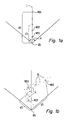
- FIGS 1a and 1b show schematic views of an embodiment according to the invention.
- GSM Global System for Mobile Communication
- communications may be built up between a base station BS and a number of mobile stations MS.
- the mobile stations MS are used by users and may change their geographical location due to movements of the users.
- the base station is operated by a provider who offers location-based services to the user.
- GPS Global Positioning System
- this service requests the geographical information of the mobile station MS of the user.
- the base station BS evaluates geographical information according to the second method as described above. This means that the base station BS evaluates the identification of the cell in which the mobile station MS is located at present as well as e.g. the distance of the mobile station MS from the base station BS. This geographical information is forwarded to a location estimator which is located within the radio communication system.
- Figure 1a shows the base station BS and a number of estimated locations of mobile stations MS1 to MS5.
- the mobile stations MS1 to MS5 do not have a GPS receiver.
- the base station BS transmits its signals in those directions as defined by the transmission angle A in figure 1a.
- the distances d1 to d5 between the base station BS and the different mobile stations MS1 to MS5 are measured and evaluated according to the described second method.
- all estimated locations of the mobile stations MS1 to MS5 are depicted in figure 1a in one line L one after the other with their evaluated respective evaluated distances d1 to d5.
- the estimated positions of the mobile stations MS1 to MS5 within figure 1a are only correct with regard to their distances d1 to d5 but not with regard to the angle given by the line L.
- the mobile station MS of the user comprises a GPS receiver and is therefore able to receive GPS signals.
- this mobile station MS forwards these GPS signals or the resulting geographical information to the location estimator.
- the geographical information according to the second method is evaluated as described above. This means that the identification of the cell in which the mobile station MS is located at present as well as e.g. the distance of the mobile station MS from the base station BS is evaluated. This geographical information is also forwarded to the location estimator. All information is stored in the location estimator.
- Figure 1b corresponds to figure 1a. It also shows the base station BS and the mobile stations MS1 to MS5. Again, the mobile stations MS1 to MS5 do not have a GPS receiver. However, in addition to figure 1a, figure 1b shows a number of positions G which result from geographical information measured by those mobile stations MS which comprise a GPS receiver.
- these positions G are not equally distributed within the angle A of the base station BS. Instead, there are areas with a higher concentration of the positions G and areas with a lower concentration of the positions G.
- the areas with a higher concentration could be streets or the like and the areas with a lower concentration could be woods or the like.
- the positions G are concentrated along a slope which could be e.g. a curved street.
- the location estimator now adapts the positions of the mobile stations MS1 to MS5 as shown in figure 1a depending on the positions G of figure 1b. As described, the positions of the mobile stations MS1 to MS5 of figure 1a are evaluated without having GPS receivers whereas the positions G of figure 1b are evaluated based on GPS receivers.
- the positions of the mobile stations MS1 to MS5 are adapted such that they are located in areas with a high concentration of positions G. This adaptation is based on the assumption that it is more probable that the mobile stations MS1 to MS5 are somewhere along e.g. the street and not in the wood.
- the distances d1 to d5 are also adapted using the GPS geographical information of other mobile stations.
- the adaptation may not only relate to the respective angles of the positions of the mobile stations MS1 to MS5 within the angle A of the base station BS but also to the distances d1 to d5 of these mobile stations MS1 to MS5.
- the adaptation may be carried out in various ways. As already described, it is possible to evaluate areas with a higher and lower concentration of positions G measured by GPS receivers and to adapt the positions of the mobile stations MS in the direction of the areas with a higher concentration. In addition it is also possible to evaluate statistical probabilities based on the positions G which may then be used to carry out the adaptation of the positions of the mobile stations MS. As well, it is possible to evaluate average positions between the GPS based geographical information measured by a GPS receiver of a mobile station MS and the cell based geographical information evaluated by the location estimator for the same mobile station at the same time. Based on such average positions, the positions of other mobile stations MS having no GPS receiver may be adapted.
- the described adaptation of the position of a mobile station MS having no GPS receiver may only lead to minor increases of the accuracy of the evaluated position of the respective mobile station MS. However, if the number of positions G increases, the accuracy of the evaluated positions of mobile stations MS having no GPS receiver also increases. Insofar, the described adaptation comprises a self-learning component which results in increasing accuracy.
Abstract
Description
Claims (12)
- A method of increasing the accuracy of geographical information of a mobile station of a radio communication system, wherein the geographical information of the mobile station is evaluated without using a GPS receiver, and wherein stored positions of other mobile stations using GPS receivers, are used to adapt the geographical information.
- The method of claim 1, wherein the geographical information is evaluated based on an identification of a cell in which the mobile station is located at present.
- The method of claim 2, wherein the geographical information is evaluated based on an estimated distance of the mobile station from a base station.
- The method of claim 3, wherein the distance is evaluated by measuring the strength of the signal being transmitted from the mobile station to the base station.
- The method of claim 3 or 4 wherein the distance is evaluated by measuring the propagation time of the signal being transmitted from the mobile station to the base station.
- The method of one of claims 1 to 5, wherein the other mobile stations receive a GPS signal and provide their positions to a location estimator, and wherein the positions are stored in the location estimator.
- The method of claim 6, wherein the location estimator evaluates the positions and defines areas with a higher concentration of positions and areas with a lower concentration of positions.
- The method of claim 7, wherein the geographical information of the mobile station without a GPS receiver is adapted such that it is more in an area with a higher concentration of positions.
- The method of one of claims 7 or 8, wherein the geographical information of the mobile station without a GPS receiver is evaluated depending on statistical probabilities of the positions of those mobile stations having a GPS receiver.
- A mobile station of a radio communication system, wherein geographical information of the mobile station is evaluated without using a GPS receiver, and wherein stored positions of other mobile stations using GPS receivers, are used to adapt the geographical information.
- A location estimator located within a radio communication system, the radio communication system comprising a mobile station, wherein geographical information of the mobile station is evaluated without using a GPS receiver, and wherein stored positions of other mobile stations using GPS receivers, are used to adapt the geographical information.
- A radio communication system comprising a mobile station, wherein geographical information of the mobile station is evaluated without using a GPS receiver, and wherein stored positions of other mobile stations using GPS receivers, are used to adapt the geographical information.
Priority Applications (5)
| Application Number | Priority Date | Filing Date | Title |
|---|---|---|---|
| AT03291242T ATE343143T1 (en) | 2003-05-23 | 2003-05-23 | METHOD FOR IMPROVING THE ACCURACY OF GEOGRAPHICAL INFORMATION OF A MOVING STATION IN A RADIO COMMUNICATIONS SYSTEM |
| EP03291242A EP1480052B1 (en) | 2003-05-23 | 2003-05-23 | Method of increasing the accuracy of geographical information of a mobile station of a radio communication system |
| DE60309135T DE60309135T2 (en) | 2003-05-23 | 2003-05-23 | A method for improving the accuracy of geographic information of a mobile station in a radio communication system |
| US10/844,566 US7242349B2 (en) | 2003-05-23 | 2004-05-13 | Method of increasing the accuracy of geographical information of a mobile station of a radio communication system |
| CNB2004100424541A CN100470253C (en) | 2003-05-23 | 2004-05-21 | Method of increasing the accuracy of geographical information of a mobile station of a radio communication system |
Applications Claiming Priority (1)
| Application Number | Priority Date | Filing Date | Title |
|---|---|---|---|
| EP03291242A EP1480052B1 (en) | 2003-05-23 | 2003-05-23 | Method of increasing the accuracy of geographical information of a mobile station of a radio communication system |
Publications (2)
| Publication Number | Publication Date |
|---|---|
| EP1480052A1 true EP1480052A1 (en) | 2004-11-24 |
| EP1480052B1 EP1480052B1 (en) | 2006-10-18 |
Family
ID=33041124
Family Applications (1)
| Application Number | Title | Priority Date | Filing Date |
|---|---|---|---|
| EP03291242A Expired - Lifetime EP1480052B1 (en) | 2003-05-23 | 2003-05-23 | Method of increasing the accuracy of geographical information of a mobile station of a radio communication system |
Country Status (5)
| Country | Link |
|---|---|
| US (1) | US7242349B2 (en) |
| EP (1) | EP1480052B1 (en) |
| CN (1) | CN100470253C (en) |
| AT (1) | ATE343143T1 (en) |
| DE (1) | DE60309135T2 (en) |
Cited By (1)
| Publication number | Priority date | Publication date | Assignee | Title |
|---|---|---|---|---|
| WO2010003898A1 (en) * | 2008-07-08 | 2010-01-14 | Gilles Rooss | Environment-driven adaptive geolocation system |
Families Citing this family (2)
| Publication number | Priority date | Publication date | Assignee | Title |
|---|---|---|---|---|
| KR20100065964A (en) * | 2008-12-09 | 2010-06-17 | 삼성전자주식회사 | Method for locating mobile terminal and system |
| JP4750841B2 (en) * | 2008-12-15 | 2011-08-17 | 株式会社エヌ・ティ・ティ・ドコモ | Mobile terminal and location information acquisition method |
Citations (3)
| Publication number | Priority date | Publication date | Assignee | Title |
|---|---|---|---|---|
| WO1998010307A1 (en) * | 1996-09-09 | 1998-03-12 | Dennis Jay Dupray | Location of a mobile station |
| WO1998057506A1 (en) * | 1997-06-12 | 1998-12-17 | Northern Telecom Limited | Directory service based on geographic location of a mobile telecommunications unit |
| WO2003038466A2 (en) * | 2001-10-29 | 2003-05-08 | Qualcomm Incorporated | Base station time calibration using position measurement data sent by mobile stations during regular position location sessions |
Family Cites Families (10)
| Publication number | Priority date | Publication date | Assignee | Title |
|---|---|---|---|---|
| JPH0820504B2 (en) * | 1987-09-22 | 1996-03-04 | 株式会社豊田中央研究所 | GPS navigation device |
| WO1995018432A1 (en) * | 1993-12-30 | 1995-07-06 | Concord, Inc. | Field navigation system |
| US5559520A (en) * | 1994-09-26 | 1996-09-24 | Lucent Technologies Inc. | Wireless information system for acquiring location related information |
| US5553407A (en) * | 1995-06-19 | 1996-09-10 | Vermeer Manufacturing Company | Excavator data acquisition and control system and method of use |
| IS2365B (en) * | 1998-02-23 | 2008-06-15 | Stj÷rnu Oddi ehf | Systems, equipment and method for geographical location of aquatic and marine organisms |
| US5982324A (en) * | 1998-05-14 | 1999-11-09 | Nortel Networks Corporation | Combining GPS with TOA/TDOA of cellular signals to locate terminal |
| US6658349B2 (en) * | 2001-05-14 | 2003-12-02 | James Douglas Cline | Method and system for marine vessel tracking system |
| GB2384354A (en) * | 2002-01-18 | 2003-07-23 | Yeoman Group Plc | Navigation System |
| US20030182026A1 (en) * | 2002-03-21 | 2003-09-25 | International Business Machines Corporation | Method and system for adaptively controlling a plurality of automotive control system nodes based upon geographic location |
| US6937872B2 (en) * | 2002-04-15 | 2005-08-30 | Qualcomm Incorporated | Methods and apparatuses for measuring frequencies of basestations in cellular networks using mobile GPS receivers |
-
2003
- 2003-05-23 DE DE60309135T patent/DE60309135T2/en not_active Expired - Lifetime
- 2003-05-23 EP EP03291242A patent/EP1480052B1/en not_active Expired - Lifetime
- 2003-05-23 AT AT03291242T patent/ATE343143T1/en not_active IP Right Cessation
-
2004
- 2004-05-13 US US10/844,566 patent/US7242349B2/en active Active
- 2004-05-21 CN CNB2004100424541A patent/CN100470253C/en not_active Expired - Fee Related
Patent Citations (3)
| Publication number | Priority date | Publication date | Assignee | Title |
|---|---|---|---|---|
| WO1998010307A1 (en) * | 1996-09-09 | 1998-03-12 | Dennis Jay Dupray | Location of a mobile station |
| WO1998057506A1 (en) * | 1997-06-12 | 1998-12-17 | Northern Telecom Limited | Directory service based on geographic location of a mobile telecommunications unit |
| WO2003038466A2 (en) * | 2001-10-29 | 2003-05-08 | Qualcomm Incorporated | Base station time calibration using position measurement data sent by mobile stations during regular position location sessions |
Cited By (1)
| Publication number | Priority date | Publication date | Assignee | Title |
|---|---|---|---|---|
| WO2010003898A1 (en) * | 2008-07-08 | 2010-01-14 | Gilles Rooss | Environment-driven adaptive geolocation system |
Also Published As
| Publication number | Publication date |
|---|---|
| CN1573353A (en) | 2005-02-02 |
| DE60309135D1 (en) | 2006-11-30 |
| EP1480052B1 (en) | 2006-10-18 |
| CN100470253C (en) | 2009-03-18 |
| ATE343143T1 (en) | 2006-11-15 |
| US7242349B2 (en) | 2007-07-10 |
| US20040233104A1 (en) | 2004-11-25 |
| DE60309135T2 (en) | 2007-02-08 |
Similar Documents
| Publication | Publication Date | Title |
|---|---|---|
| CN100534235C (en) | Method and system for validating mobile station location fix | |
| US8406785B2 (en) | Method and system for estimating range of mobile device to wireless installation | |
| KR100303290B1 (en) | A method for computing error distance and distance between base station and mobile telephone | |
| CN101536596B (en) | Method and device for determination of the position of a terminal in a mobile communication network | |
| US20070010259A1 (en) | Method and apparatus for providing a wireless transmit/receive unit user with signal quality guidance | |
| US20080119208A1 (en) | Locating a mobile station inside a building | |
| CN102778685A (en) | Cooperative positioning | |
| HK1038840A1 (en) | System and method for narrowing the range of frequency uncertainty of a doppler shifted signal. | |
| US7925205B2 (en) | System and method of operation for network overlay geolocation system with repeaters | |
| CN101965051A (en) | Positioning method and positioning server | |
| CN103858495A (en) | Methods and arrangements for positioning in wireless communication systems | |
| KR100768573B1 (en) | Method and apparatus for providing automatic location information calibration of mobile terminal | |
| US20110034122A1 (en) | System and Method of Operation For Network Overlay Geolocation System With Repeaters | |
| CN1112832C (en) | Mobile terminal self-positioning method | |
| KR100524180B1 (en) | Position tracking method of a mobile phone using cell position and receiving/pre-measured radio wave characteristic information | |
| JP2010527025A (en) | Location estimation on end-user devices using public radio signals | |
| US7242349B2 (en) | Method of increasing the accuracy of geographical information of a mobile station of a radio communication system | |
| WO2005103753A1 (en) | Repeater with positioning capabilities | |
| KR101301246B1 (en) | System and method for measuring position of mobile communication terminal | |
| CN1816168A (en) | Method for forecasting weather information using place information of mobile telecommunication terminal machine | |
| KR100400556B1 (en) | Position monitoring method for mobile communication device | |
| KR100443334B1 (en) | Method for Notifying Destination-related Information by using Mobile Station with GPS | |
| KR20100037532A (en) | Apparatus and method for determining the position | |
| EP1141742A1 (en) | Locating system for mobile stations | |
| KR20050064608A (en) | Method for reporting reservation of weather data using of location of mobile communication termianl |
Legal Events
| Date | Code | Title | Description |
|---|---|---|---|
| PUAI | Public reference made under article 153(3) epc to a published international application that has entered the european phase |
Free format text: ORIGINAL CODE: 0009012 |
|
| AK | Designated contracting states |
Kind code of ref document: A1 Designated state(s): AT BE BG CH CY CZ DE DK EE ES FI FR GB GR HU IE IT LI LU MC NL PT RO SE SI SK TR |
|
| AX | Request for extension of the european patent |
Extension state: AL LT LV MK |
|
| 17P | Request for examination filed |
Effective date: 20041006 |
|
| AKX | Designation fees paid |
Designated state(s): AT BE BG CH CY CZ DE DK EE ES FI FR GB GR HU IE IT LI LU MC NL PT RO SE SI SK TR |
|
| GRAP | Despatch of communication of intention to grant a patent |
Free format text: ORIGINAL CODE: EPIDOSNIGR1 |
|
| GRAS | Grant fee paid |
Free format text: ORIGINAL CODE: EPIDOSNIGR3 |
|
| GRAA | (expected) grant |
Free format text: ORIGINAL CODE: 0009210 |
|
| RIN1 | Information on inventor provided before grant (corrected) |
Inventor name: TANGEMANN, MICHAEL, DR. ING. |
|
| AK | Designated contracting states |
Kind code of ref document: B1 Designated state(s): AT BE BG CH CY CZ DE DK EE ES FI FR GB GR HU IE IT LI LU MC NL PT RO SE SI SK TR |
|
| PG25 | Lapsed in a contracting state [announced via postgrant information from national office to epo] |
Ref country code: SK Free format text: LAPSE BECAUSE OF FAILURE TO SUBMIT A TRANSLATION OF THE DESCRIPTION OR TO PAY THE FEE WITHIN THE PRESCRIBED TIME-LIMIT Effective date: 20061018 Ref country code: LI Free format text: LAPSE BECAUSE OF FAILURE TO SUBMIT A TRANSLATION OF THE DESCRIPTION OR TO PAY THE FEE WITHIN THE PRESCRIBED TIME-LIMIT Effective date: 20061018 Ref country code: SI Free format text: LAPSE BECAUSE OF FAILURE TO SUBMIT A TRANSLATION OF THE DESCRIPTION OR TO PAY THE FEE WITHIN THE PRESCRIBED TIME-LIMIT Effective date: 20061018 Ref country code: FI Free format text: LAPSE BECAUSE OF FAILURE TO SUBMIT A TRANSLATION OF THE DESCRIPTION OR TO PAY THE FEE WITHIN THE PRESCRIBED TIME-LIMIT Effective date: 20061018 Ref country code: CH Free format text: LAPSE BECAUSE OF FAILURE TO SUBMIT A TRANSLATION OF THE DESCRIPTION OR TO PAY THE FEE WITHIN THE PRESCRIBED TIME-LIMIT Effective date: 20061018 Ref country code: RO Free format text: LAPSE BECAUSE OF FAILURE TO SUBMIT A TRANSLATION OF THE DESCRIPTION OR TO PAY THE FEE WITHIN THE PRESCRIBED TIME-LIMIT Effective date: 20061018 Ref country code: CZ Free format text: LAPSE BECAUSE OF FAILURE TO SUBMIT A TRANSLATION OF THE DESCRIPTION OR TO PAY THE FEE WITHIN THE PRESCRIBED TIME-LIMIT Effective date: 20061018 Ref country code: NL Free format text: LAPSE BECAUSE OF FAILURE TO SUBMIT A TRANSLATION OF THE DESCRIPTION OR TO PAY THE FEE WITHIN THE PRESCRIBED TIME-LIMIT Effective date: 20061018 Ref country code: BE Free format text: LAPSE BECAUSE OF FAILURE TO SUBMIT A TRANSLATION OF THE DESCRIPTION OR TO PAY THE FEE WITHIN THE PRESCRIBED TIME-LIMIT Effective date: 20061018 Ref country code: AT Free format text: LAPSE BECAUSE OF FAILURE TO SUBMIT A TRANSLATION OF THE DESCRIPTION OR TO PAY THE FEE WITHIN THE PRESCRIBED TIME-LIMIT Effective date: 20061018 |
|
| REG | Reference to a national code |
Ref country code: GB Ref legal event code: FG4D |
|
| REG | Reference to a national code |
Ref country code: IE Ref legal event code: FG4D Ref country code: CH Ref legal event code: EP |
|
| REF | Corresponds to: |
Ref document number: 60309135 Country of ref document: DE Date of ref document: 20061130 Kind code of ref document: P |
|
| PG25 | Lapsed in a contracting state [announced via postgrant information from national office to epo] |
Ref country code: BG Free format text: LAPSE BECAUSE OF FAILURE TO SUBMIT A TRANSLATION OF THE DESCRIPTION OR TO PAY THE FEE WITHIN THE PRESCRIBED TIME-LIMIT Effective date: 20070118 Ref country code: SE Free format text: LAPSE BECAUSE OF FAILURE TO SUBMIT A TRANSLATION OF THE DESCRIPTION OR TO PAY THE FEE WITHIN THE PRESCRIBED TIME-LIMIT Effective date: 20070118 Ref country code: DK Free format text: LAPSE BECAUSE OF FAILURE TO SUBMIT A TRANSLATION OF THE DESCRIPTION OR TO PAY THE FEE WITHIN THE PRESCRIBED TIME-LIMIT Effective date: 20070118 |
|
| PG25 | Lapsed in a contracting state [announced via postgrant information from national office to epo] |
Ref country code: ES Free format text: LAPSE BECAUSE OF FAILURE TO SUBMIT A TRANSLATION OF THE DESCRIPTION OR TO PAY THE FEE WITHIN THE PRESCRIBED TIME-LIMIT Effective date: 20070129 |
|
| PG25 | Lapsed in a contracting state [announced via postgrant information from national office to epo] |
Ref country code: PT Free format text: LAPSE BECAUSE OF FAILURE TO SUBMIT A TRANSLATION OF THE DESCRIPTION OR TO PAY THE FEE WITHIN THE PRESCRIBED TIME-LIMIT Effective date: 20070319 |
|
| NLV1 | Nl: lapsed or annulled due to failure to fulfill the requirements of art. 29p and 29m of the patents act | ||
| ET | Fr: translation filed | ||
| REG | Reference to a national code |
Ref country code: CH Ref legal event code: PL |
|
| RAP2 | Party data changed (patent owner data changed or rights of a patent transferred) |
Owner name: ALCATEL LUCENT |
|
| PLBE | No opposition filed within time limit |
Free format text: ORIGINAL CODE: 0009261 |
|
| STAA | Information on the status of an ep patent application or granted ep patent |
Free format text: STATUS: NO OPPOSITION FILED WITHIN TIME LIMIT |
|
| 26N | No opposition filed |
Effective date: 20070719 |
|
| PG25 | Lapsed in a contracting state [announced via postgrant information from national office to epo] |
Ref country code: MC Free format text: LAPSE BECAUSE OF NON-PAYMENT OF DUE FEES Effective date: 20070531 |
|
| PG25 | Lapsed in a contracting state [announced via postgrant information from national office to epo] |
Ref country code: GR Free format text: LAPSE BECAUSE OF FAILURE TO SUBMIT A TRANSLATION OF THE DESCRIPTION OR TO PAY THE FEE WITHIN THE PRESCRIBED TIME-LIMIT Effective date: 20070119 |
|
| PG25 | Lapsed in a contracting state [announced via postgrant information from national office to epo] |
Ref country code: IE Free format text: LAPSE BECAUSE OF NON-PAYMENT OF DUE FEES Effective date: 20070523 |
|
| PG25 | Lapsed in a contracting state [announced via postgrant information from national office to epo] |
Ref country code: EE Free format text: LAPSE BECAUSE OF FAILURE TO SUBMIT A TRANSLATION OF THE DESCRIPTION OR TO PAY THE FEE WITHIN THE PRESCRIBED TIME-LIMIT Effective date: 20061018 |
|
| PG25 | Lapsed in a contracting state [announced via postgrant information from national office to epo] |
Ref country code: CY Free format text: LAPSE BECAUSE OF FAILURE TO SUBMIT A TRANSLATION OF THE DESCRIPTION OR TO PAY THE FEE WITHIN THE PRESCRIBED TIME-LIMIT Effective date: 20061018 Ref country code: LU Free format text: LAPSE BECAUSE OF NON-PAYMENT OF DUE FEES Effective date: 20070523 |
|
| PG25 | Lapsed in a contracting state [announced via postgrant information from national office to epo] |
Ref country code: TR Free format text: LAPSE BECAUSE OF FAILURE TO SUBMIT A TRANSLATION OF THE DESCRIPTION OR TO PAY THE FEE WITHIN THE PRESCRIBED TIME-LIMIT Effective date: 20061018 Ref country code: HU Free format text: LAPSE BECAUSE OF FAILURE TO SUBMIT A TRANSLATION OF THE DESCRIPTION OR TO PAY THE FEE WITHIN THE PRESCRIBED TIME-LIMIT Effective date: 20070419 |
|
| REG | Reference to a national code |
Ref country code: FR Ref legal event code: TP Owner name: ALCATEL LUCENT, FR Effective date: 20130612 Ref country code: FR Ref legal event code: CA Effective date: 20130612 |
|
| REG | Reference to a national code |
Ref country code: FR Ref legal event code: GC Effective date: 20130920 |
|
| REG | Reference to a national code |
Ref country code: FR Ref legal event code: RG Effective date: 20141016 |
|
| REG | Reference to a national code |
Ref country code: FR Ref legal event code: PLFP Year of fee payment: 13 |
|
| REG | Reference to a national code |
Ref country code: FR Ref legal event code: PLFP Year of fee payment: 14 |
|
| REG | Reference to a national code |
Ref country code: FR Ref legal event code: PLFP Year of fee payment: 15 |
|
| REG | Reference to a national code |
Ref country code: FR Ref legal event code: PLFP Year of fee payment: 16 |
|
| PGFP | Annual fee paid to national office [announced via postgrant information from national office to epo] |
Ref country code: DE Payment date: 20190508 Year of fee payment: 17 Ref country code: IT Payment date: 20190527 Year of fee payment: 17 |
|
| PGFP | Annual fee paid to national office [announced via postgrant information from national office to epo] |
Ref country code: FR Payment date: 20190410 Year of fee payment: 17 |
|
| PGFP | Annual fee paid to national office [announced via postgrant information from national office to epo] |
Ref country code: GB Payment date: 20190522 Year of fee payment: 17 |
|
| REG | Reference to a national code |
Ref country code: DE Ref legal event code: R119 Ref document number: 60309135 Country of ref document: DE |
|
| GBPC | Gb: european patent ceased through non-payment of renewal fee |
Effective date: 20200523 |
|
| PG25 | Lapsed in a contracting state [announced via postgrant information from national office to epo] |
Ref country code: GB Free format text: LAPSE BECAUSE OF NON-PAYMENT OF DUE FEES Effective date: 20200523 Ref country code: FR Free format text: LAPSE BECAUSE OF NON-PAYMENT OF DUE FEES Effective date: 20200531 |
|
| PG25 | Lapsed in a contracting state [announced via postgrant information from national office to epo] |
Ref country code: DE Free format text: LAPSE BECAUSE OF NON-PAYMENT OF DUE FEES Effective date: 20201201 |
|
| PG25 | Lapsed in a contracting state [announced via postgrant information from national office to epo] |
Ref country code: IT Free format text: LAPSE BECAUSE OF NON-PAYMENT OF DUE FEES Effective date: 20200523 |