EP1407295B1 - Verfahren zur durchführung einer konnektivitätsanalyse auf objektbasis in seismischen 3d-datenvolumen - Google Patents
Verfahren zur durchführung einer konnektivitätsanalyse auf objektbasis in seismischen 3d-datenvolumen Download PDFInfo
- Publication number
- EP1407295B1 EP1407295B1 EP02739930.2A EP02739930A EP1407295B1 EP 1407295 B1 EP1407295 B1 EP 1407295B1 EP 02739930 A EP02739930 A EP 02739930A EP 1407295 B1 EP1407295 B1 EP 1407295B1
- Authority
- EP
- European Patent Office
- Prior art keywords
- seismic
- attribute
- threshold
- objects
- value
- Prior art date
- Legal status (The legal status is an assumption and is not a legal conclusion. Google has not performed a legal analysis and makes no representation as to the accuracy of the status listed.)
- Expired - Lifetime
Links
- 238000000034 method Methods 0.000 title claims description 32
- 230000000007 visual effect Effects 0.000 claims description 4
- FGUUSXIOTUKUDN-IBGZPJMESA-N C1(=CC=CC=C1)N1C2=C(NC([C@H](C1)NC=1OC(=NN=1)C1=CC=CC=C1)=O)C=CC=C2 Chemical compound C1(=CC=CC=C1)N1C2=C(NC([C@H](C1)NC=1OC(=NN=1)C1=CC=CC=C1)=O)C=CC=C2 FGUUSXIOTUKUDN-IBGZPJMESA-N 0.000 claims 3
- 238000009877 rendering Methods 0.000 description 7
- 230000008569 process Effects 0.000 description 5
- 238000001514 detection method Methods 0.000 description 4
- 238000012986 modification Methods 0.000 description 3
- 230000004048 modification Effects 0.000 description 3
- 230000003993 interaction Effects 0.000 description 2
- 230000037361 pathway Effects 0.000 description 2
- 230000002250 progressing effect Effects 0.000 description 2
- 238000012800 visualization Methods 0.000 description 2
- 239000004215 Carbon black (E152) Substances 0.000 description 1
- 230000008901 benefit Effects 0.000 description 1
- 230000015572 biosynthetic process Effects 0.000 description 1
- 210000000988 bone and bone Anatomy 0.000 description 1
- 230000002950 deficient Effects 0.000 description 1
- 238000010586 diagram Methods 0.000 description 1
- 230000008034 disappearance Effects 0.000 description 1
- 238000011156 evaluation Methods 0.000 description 1
- 238000000605 extraction Methods 0.000 description 1
- 238000005755 formation reaction Methods 0.000 description 1
- 229930195733 hydrocarbon Natural products 0.000 description 1
- 125000001183 hydrocarbyl group Chemical group 0.000 description 1
- 230000002452 interceptive effect Effects 0.000 description 1
- 238000002372 labelling Methods 0.000 description 1
- 230000005012 migration Effects 0.000 description 1
- 238000013508 migration Methods 0.000 description 1
- 239000003208 petroleum Substances 0.000 description 1
- 238000012545 processing Methods 0.000 description 1
- 210000004872 soft tissue Anatomy 0.000 description 1
- 230000009897 systematic effect Effects 0.000 description 1
Images


Classifications
-
- G—PHYSICS
- G01—MEASURING; TESTING
- G01V—GEOPHYSICS; GRAVITATIONAL MEASUREMENTS; DETECTING MASSES OR OBJECTS; TAGS
- G01V1/00—Seismology; Seismic or acoustic prospecting or detecting
- G01V1/28—Processing seismic data, e.g. for interpretation or for event detection
- G01V1/282—Application of seismic models, synthetic seismograms
Definitions
- This invention relates generally to the field of seismic interpretation. Specifically, the invention is a method for performing a deterministic analysis of the likelihood of connectivity of seismic objects that satisfy certain attribute criteria.
- a common problem in 3D seismic interpretation is the extraction of geologic features from an attribute volume and evaluation of their geometric relationships to each other and implications for connectivity.
- Bulk processing of a seismic volume results in the detection of one or more seismic "objects" at a certain attribute threshold.
- An "object” is defined as a region in which the value of a certain selected seismic attribute (acoustic impedance, for example) satisfies some arbitrary threshold requirement, i.e. is either greater than some minimum value or is less than some maximum value.
- some arbitrary threshold requirement i.e. is either greater than some minimum value or is less than some maximum value.
- two such regions may not be connected (i.e., they are two objects); at a different threshold, they may be connected (i.e., a single object).
- the interpreter must decide which threshold depicts a scenario that is more consistent with other known information about the area. Selection of an appropriate threshold is not always straightforward and it may take multiple iterations to achieve the desired result. [The desired result of course, is that the seismic objects should correspond to actual underground reservoirs, and where two objects are interpreted as either connected or not, that would mean that the corresponding reservoirs if they contain oil or gas, would also be connected (or not), meaning that a well producing one reservoir can also drain the other (or cannot).] Interpretation time could be reduced significantly if one could bulk process a seismic volume, and generate a collection of seismic objects detected at various attribute thresholds as well as information about connectivity of these objects.
- the technique has been implemented in several commercial products such as VoxelGeo, GeoViz, Gocad, Jason and others. It is an interactive method, where the user specifies the initial "seed" point and attribute criteria.
- the algorithm marks the initial point as belonging to the current object, and tries to find this point's neighbors that satisfy the specified attribute criteria. The new points are added to the current object, and the procedure continues until it is not possible to find any new neighbors fulfilling the specified criteria.
- Seed picking requires a criterion for connectedness. There are two criteria commonly used, although others may be defined and used. One definition is that two cells are connected (i.e., are neighbors) if they share a common face. By this definition of connectivity, a cell (or voxel) can have up to six neighbors. The other common criterion for being a neighbor is sharing either an edge, a face, or a corner. By this criterion, a cell can have up to twenty-six neighbors.
- Seed picking may have originated in medical applications.
- U.S. Patent No. 4,751,643 to William Lorensen and Harvey Cline discloses a specific seed picking algorithm that enables radiologists and surgeons to display only bone tissue or only soft tissue and provides them with extensive preoperative information.
- the algorithm is claimed to be very fast because it accesses the original data values only once.
- the first step is labeling, which means checking the attribute criteria for each voxel. It marks cells fulfilling the criteria as 1, and the others as 0.
- the connectivity (region growing) algorithm is employed which works on this single-bit data set.
- What is needed to improve upon existing seed detection methods is a fast method of determining from a single seismic data set the connectivity between objects that may be connected at certain attribute thresholds but not at others, and a systematic way of keeping track of such connectivity as a function of attribute threshold.
- the present inventive method satisfies these needs.
- the present invention is a method for predicting connectivity of seismic objects determined from seismic data collected from a subterranean region, where the method comprises the steps of (a) dividing the subterranean region into cells and determining from the seismic data the value of a preselected seismic attribute in each cell; (b) choosing a threshold criterion for the value of the seismic attribute; (c) determining for each cell whether the value of the selected attribute for that cell satisfies the chosen criterion; (d) identifying seismic objects containing only connected cells that satisfy the attribute criterion, using a pre-selected definition of connectivity; (e) repeating steps (b) - (d) for at least one different value of the attribute threshold; and (f) displaying the changes of each seismic object identified in its size, spatial position, and connection to other objects, all as a function of attribute threshold value.
- objects are discarded if they are smaller in size than a pre-selected minimum size. In other embodiments, objects are discarded if they are larger than a preselected maximum size. In some preferred embodiments, the attribute and/or object size thresholds are varied beginning with the least restrictive values and progressing to the most restrictive values.
- a 3-D visual display is used to present the results in step (d) above, thereby aiding the tracking of step (f).
- a 2-D hierarchical tree is used to graphically display the findings of step (f).
- step (f) may be used to predict connectivity of actual hydrocarbon-bearing formations.
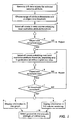
- Figure 1 is a flow chart of some embodiments of the present invention.
- Figures 2A-B to 6A-B depict examples of 3-D visualization (A) and tree graph (B) displays obtainable with the present invention.
- Figure 7 illustrates the interplay between the present invention's criteria and thresholds.
- Figure 1 may be referred to for some preferred embodiments of the invention.
- the user At step 1, the user generates a 3-D data volume for some selected seismic attribute.
- the attribute could be acoustic impedance, and the impedance values might be obtained by inverting seismic data.
- the data volume might be values of the seismic amplitudes themselves, and the terms "seismic attribute” or “attribute” as used herein will be understood to be broad enough to encompass this.
- the selected attribute may be discontinuity or any other attribute besides amplitude or impedance.
- the term "data volume” merely means that the value of the attribute is known at all spatial locations within the chosen subterranean volume at discrete points on a 3-D grid.
- the user selects one or more object size thresholds and several attribute threshold values spanning the range of interest.
- the initial attribute threshold might be some minimum value of seismic amplitude, or some maximum value of acoustic impedance. Additional attribute threshold values are selected by progressively increasing the minimum value, where the threshold is a minimum value, perhaps by regular intervals.
- the object size threshold will usually be a minimum size, with objects smaller than that ignored and not displayed. In some instances, specifying a maximum object size in addition to or instead of the minimum value may be useful.
- Connectivity criteria must also be defined. Voxels may be considered neighbors, i.e., connected, in various ways, as discussed previously.
- a specific connectivity, criterion must be used.
- the software program will allow the user to choose among different connectivity criterion options. (This selection can be considered part of Step 2.)
- Step 3 every point (or voxel) in the data volume is checked, and those satisfying the initial attribute and object size thresholds are identified, preferably in an automated manner using a software algorithm.
- the initial thresholds will be the least restrictive of the choices from step 2.
- the voxels thus identified comprise seismic objects or geobodies.
- step 3 is accomplished by an object-detection algorithm which starts by examining voxels until it finds one that meets the specified attribute criterion. This voxel is marked as belonging to an object or geobody. Then a region-growing algorithm is applied to this voxel. Such algorithm looks at neighboring voxels and identifies those that meet the attribute criterion. The neighbors are either face neighbors or edge/corner/face neighbors, depending upon which criterion the user specifies. Such neighbors that satisfy the attribute threshold are included in the geobody, and region growing is applied to them, and so on in this manner until region growing has been applied to all voxels in the present geobody and there are no more neighbors that meet the attribute threshold. At this point, the object size threshold is checked. If the object does not meet this size threshold, it is rejected.
- the algorithm looks for an unconnected voxel that satisfies the attribute threshold. If it finds one, the cycle of finding neighbors and applying region growing is repeated, looking only at voxels not in the first object or examined during the growing of the first object. When a second object is identified, the size criterion is checked again. The algorithm stops only when all voxels in the 3-D volume have been examined and either included in an object or rejected. (Step 3 is now completed.)
- Any object identification method that checks every voxel in the 3-D volume may be used.
- Preferred methods are those that check each voxel only once for given values of the input thresholds.
- the attribute size threshold is varied to the next least restrictive value.
- the preceding object identification process is repeated, but in preferred embodiments of the present invention, the only voxels that will be examined are those voxels that are part of an object at the previous attribute threshold.
- the size of the objects will decrease, and there is no need to examine voxels that were not part of an object at the previous threshold.
- Step 5 the location of each voxel belonging to an object at each attribute threshold is stored externally.
- This information is a database from which the "history" of each object from one threshold to the next can be captured and visually displayed (Steps 6 and 7), which is a key feature of the present inventive method in its preferred embodiments. The operator is able to observe from such displays whether an object disappears at a more restrictive threshold, or whether it splits into one or more smaller objects, or whether it remains a single object of the same or smaller size. This information enables the operator to make informed judgements on whether seismic objects are connected with each other, with some sense of how strong that connectivity may be.
- the "tree graph" of step 6 is a preferred way to capture the connectivity history in a useful visual display.
- the tree graph is explained and illustrated further in the examples provided below.
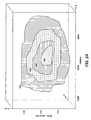
- Figure 2A shows a highly connected seismic object, which changes minimally for tighter thresholds. It gets progressively smaller. At the least restrictive threshold t 1, the object is at its largest (101). When the threshold is tightened to t 2, the object 12 is reduced in size, but still a single object (102), and similarly for successively tighter thresholds t 3 and t 4 and smaller objects (103) and (104).
- Figure 2B is the tree graph that corresponds to Fig. 2A .
- a 3-D visualization application would display both the 3-D volume rendering and the corresponding 2-D tree graph.
- the boxes of a tree graph may contain information about the geobody at the corresponding threshold.
- a box may include a number assigned to the geobody for identification purposes; the size of the geobody in voxels or other units; the threshold at which the geobody was detected (in Fig. 2B , that threshold would be t 1); the (x, y, z) location of the geobody relative to some reference coordinate system; and any other useful information such as the length and width of the geobody.
- the thresholds t 1, t 2 represent, for generality, both the attribute and object size thresholds.
- Figures 2A and 2B might want to hold the object size threshold constant, while tightening only the attribute threshold from t 1 to t 4. Alternatively, the operator might elect to tighten one or both thresholds at each step. Whatever the object size thresholds in Figures 2A and 2B , they are inoperative because the object never disappears in this example. In the simple case illustrated in Figures 2A and 2B , the tree graph adds little to what the operator can readily glean from the 3-D volume rendering, but this will not be true for more complex examples such as the example depicted in Fig. 3B .
- Figure 3B depicts a geobody 201 that at threshold t 1 looks exactly the same as the geobody 101 of Figure 2A ; however, it is not the same geobody as can be seen at threshold t 2 where it splits into two objects 202 and 203, showing weaker connectivity than the geobody of Fig. 2A .
- object 202 undergoes a further split into objects 204 and 205, while object 203 stays connected, reducing to a smaller size 206.
- t 4 all objects disappear except for 204, now reduced to a smaller size 207.
- the connectivity tree of Fig. 3B is clearly different and more complex than that of Fig. 2B .
- the object of Figure 4A also looks the same as the object of Fig. 2A at threshold t 1, i.e., 301 and 101 look the same.
- the tree graph (not shown) also looks the same as Fig. 2B , but the object size shrinks much more severely (from 302 to 303 and finally to 304) with tighter thresholds than in Fig. 2B , which size information may be displayed (not shown in the figure) in the boxes of the tree diagram.
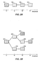
- Figures 5A and 5B illustrate more complicated connectivity. Because of the complexity, the volume rendering ( Fig. 5A ) shows the objects only at a single threshold t 2. (Note threshold t 2 "highlighted" in Fig. 5B .) However, the corresponding tree graph ( Figure 5B ) is easily able to show what happens at six different thresholds. At the least restrictive threshold t 1, there is but a single object, 400, i.e., all voxels satisfying the threshold criteria are connected except possibly for objects not satisfying the object size criterion. At the next more restrictive threshold, t 2, which is the threshold for Fig. 5A , the single object has split into four objects, 401, 402, 403 and 404. The tree graph ( Fig.
- Figure 6A uses the same data set as Figs. 5A-B , examined at the same thresholds as Figure 5B , but focusing on what happens to object 401 at tighter thresholds.
- the splitting of connected object 401 into unconnected objects 405 and 406 at tighter threshold t 2 is shown, as is the further splitting of object 405 at threshold t 3 into objects 407 and 408.
- Object 406 remains one body, but is smaller in size (409) due to a tighter attribute threshold.
- the corresponding tree graph, Figure 6B is identical to Fig. 5B except for the highlighting choices.
- the vertical (z) dimension in the volume rendering figures is given in terms of seconds of travel time, which is the directly measured quantity.
- Figure 7 provides a simplified example of the interplay between the various criteria of the present invention. Assume that the only voxels in the data volume that satisfy the attribute threshold are the five voxels 71-75, all in the same plane for conceptual simplicity. If the connectivity criterion is the 26-way (edge/corner/face) criterion, then the visual displays of the present invention will show a single object comprised of the five voxels 71-75 if the size threshold is a minimum size of 5 or fewer. If the size threshold is a minimum of 6 or greater, no objects will be displayed.
- the connectivity criterion is the 26-way (edge/corner/face) criterion
- the object size threshold is 2-4, one object will be displayed comprising the four voxels 72-75.
- size threshold ⁇ 5 no objects will be displayed.
- size threshold 1, two objects are displayed: the single voxel 71 and the four voxels 72-75.
Landscapes
- Engineering & Computer Science (AREA)
- Remote Sensing (AREA)
- Physics & Mathematics (AREA)
- Life Sciences & Earth Sciences (AREA)
- Geology (AREA)
- Environmental & Geological Engineering (AREA)
- Acoustics & Sound (AREA)
- General Life Sciences & Earth Sciences (AREA)
- General Physics & Mathematics (AREA)
- Geophysics (AREA)
- Geophysics And Detection Of Objects (AREA)
- Image Analysis (AREA)
- Image Processing (AREA)
- Management, Administration, Business Operations System, And Electronic Commerce (AREA)
- Processing Or Creating Images (AREA)
Claims (6)
- Verfahren zur Vorhersage der Konnektivität von seismischen Objekten, die aus seismischen Daten bestimmt werden, welche in einer unterirdischen Region gesammelt werden, bei dema) die unterirdische Region in Zellen unterteilt wird und in jeder Zelle aus den seismischen Daten der Wert eines vorausgewählten seismischen Attributs bestimmt wird;b) ein Schwellenwertkriterium (t1) für den Wert des seismischen Attributs gewählt wird;c) für jede Zelle in der unterirdischen Region bestimmt wird, ob der Wert des seismischen Attributs das Schwellenwertkriterium erfüllt;d) seismische (101) Objekte, die nur verbundene Zellen enthalten, welche das Attributkriterium erfüllen, dadurch identifiziert werden, dass eine vorausgewählte Definition der Konnektivität verwendet wird;e) Schritte b)-d) für mindestens einen anderen Wert (t2, t3, t4) des Attributschwellenwerts wiederholt werden undf) die Änderung von jedem identifizierten seismischen Objekt (101, 102, 103, 104) in seiner Größe, räumlicher Position und Konnektivität zu anderen seismischen Objekten als Funktion des Attributschwellenwerts (t1, t2, t3, t4) angezeigt wird.
- Verfahren nach Anspruch 1, bei dem die Ergebnisse von Schritt f) zur Vorhersage der Konnektivität von geologischen Merkmalen in der unterirdischen Region verwendet werden.
- Verfahren nach Anspruch 1, bei dem alle in Schritt d) definierten seismischen Objekte, die kleiner als eine vorausgewählte Minimalgröße sind, nicht berücksichtigt werden.
- Verfahren nach Anspruch 1, bei dem alle in Schritt d) definierten seismischen Objekte, die größer als eine vorausgewählte Maximalgröße sind, nicht berücksichtigt werden.
- Verfahren nach Anspruch 1, bei dem ein 3D-visuelles Display zum Anzeigen der Ergebnisse in Schritt d) verwendet wird, um auf diese Weise das Verfolgen des Anzeigers des seismischen Objekts in Schritt f) zu erleichtern.
- Verfahren nach Anspruch 1, bei dem ein 2D-hierarschiches Baumstrukturdisplay (tree display) verwendet wird, um die Ergebnisse aus Schritt f) graphisch darzustellen.
Applications Claiming Priority (3)
| Application Number | Priority Date | Filing Date | Title |
|---|---|---|---|
| US29952701P | 2001-06-20 | 2001-06-20 | |
| US299527P | 2001-06-20 | ||
| PCT/US2002/019411 WO2003003053A1 (en) | 2001-06-20 | 2002-06-19 | Method for performing object-based connectivity analysis in 3-d seismic data volumes |
Publications (3)
| Publication Number | Publication Date |
|---|---|
| EP1407295A1 EP1407295A1 (de) | 2004-04-14 |
| EP1407295A4 EP1407295A4 (de) | 2006-02-08 |
| EP1407295B1 true EP1407295B1 (de) | 2015-08-26 |
Family
ID=23155193
Family Applications (1)
| Application Number | Title | Priority Date | Filing Date |
|---|---|---|---|
| EP02739930.2A Expired - Lifetime EP1407295B1 (de) | 2001-06-20 | 2002-06-19 | Verfahren zur durchführung einer konnektivitätsanalyse auf objektbasis in seismischen 3d-datenvolumen |
Country Status (9)
| Country | Link |
|---|---|
| EP (1) | EP1407295B1 (de) |
| AU (1) | AU2002312550B2 (de) |
| BR (1) | BR0209313A (de) |
| CA (1) | CA2445965C (de) |
| GC (1) | GC0000395A (de) |
| MX (1) | MXPA03012062A (de) |
| MY (1) | MY130776A (de) |
| NO (1) | NO335612B1 (de) |
| WO (1) | WO2003003053A1 (de) |
Families Citing this family (7)
| Publication number | Priority date | Publication date | Assignee | Title |
|---|---|---|---|---|
| US6823266B2 (en) * | 2001-06-20 | 2004-11-23 | Exxonmobil Upstream Research Company | Method for performing object-based connectivity analysis in 3-D seismic data volumes |
| WO2005104003A1 (en) | 2004-03-31 | 2005-11-03 | Exxonmobil Upstream Research Company | Method for constructing a geologic model of a subsurface reservoir |
| WO2009075946A1 (en) | 2007-12-13 | 2009-06-18 | Exxonmobil Upstream Research Company | Iterative reservior surveillance |
| WO2009131762A2 (en) | 2008-04-22 | 2009-10-29 | Exxonmobil Upstream Research Company | Functional-based knowledge analysis in a 2d and 3d visual environment |
| AU2010345083B2 (en) | 2010-02-03 | 2016-03-10 | Exxonmobil Upstream Research Company | Method for using dynamic target region for well path/drill center optimization |
| US9223594B2 (en) | 2011-07-01 | 2015-12-29 | Exxonmobil Upstream Research Company | Plug-in installer framework |
| US9595129B2 (en) | 2012-05-08 | 2017-03-14 | Exxonmobil Upstream Research Company | Canvas control for 3D data volume processing |
Family Cites Families (8)
| Publication number | Priority date | Publication date | Assignee | Title |
|---|---|---|---|---|
| US5930730A (en) * | 1994-12-12 | 1999-07-27 | Amoco Corporation | Method and apparatus for seismic signal processing and exploration |
| US5586082A (en) * | 1995-03-02 | 1996-12-17 | The Trustees Of Columbia University In The City Of New York | Method for identifying subsurface fluid migration and drainage pathways in and among oil and gas reservoirs using 3-D and 4-D seismic imaging |
| US5671136A (en) * | 1995-12-11 | 1997-09-23 | Willhoit, Jr.; Louis E. | Process for seismic imaging measurement and evaluation of three-dimensional subterranean common-impedance objects |
| JPH116879A (ja) * | 1997-06-16 | 1999-01-12 | Osaka Gas Co Ltd | 3次元探査方法及び装置 |
| US5966672A (en) * | 1997-07-28 | 1999-10-12 | Knupp; Daniel F. | Visualization technology method |
| WO2000013037A1 (fr) * | 1998-08-31 | 2000-03-09 | Osaka Gas Co., Ltd. | Procede de recherche tridimensionnel, procede d'affichage de donnees de voxels tridimensionnelles, et dispositif de realisation de ces procedes |
| US6226596B1 (en) * | 1999-10-27 | 2001-05-01 | Marathon Oil Company | Method for analyzing and classifying three dimensional seismic information |
| US6490528B2 (en) * | 2000-04-17 | 2002-12-03 | Exxonmobil Upstream Research Company | Method for imaging discontinuites in seismic data |
-
2002
- 2002-06-10 MY MYPI20022148A patent/MY130776A/en unknown
- 2002-06-18 GC GCP20022076 patent/GC0000395A/en active
- 2002-06-19 EP EP02739930.2A patent/EP1407295B1/de not_active Expired - Lifetime
- 2002-06-19 WO PCT/US2002/019411 patent/WO2003003053A1/en active IP Right Grant
- 2002-06-19 AU AU2002312550A patent/AU2002312550B2/en not_active Ceased
- 2002-06-19 CA CA2445965A patent/CA2445965C/en not_active Expired - Fee Related
- 2002-06-19 MX MXPA03012062A patent/MXPA03012062A/es active IP Right Grant
- 2002-06-19 BR BR0209313-8A patent/BR0209313A/pt not_active Application Discontinuation
-
2003
- 2003-12-19 NO NO20035695A patent/NO335612B1/no not_active IP Right Cessation
Also Published As
| Publication number | Publication date |
|---|---|
| MY130776A (en) | 2007-07-31 |
| WO2003003053A1 (en) | 2003-01-09 |
| CA2445965C (en) | 2010-04-13 |
| NO335612B1 (no) | 2015-01-12 |
| AU2002312550B2 (en) | 2006-08-24 |
| NO20035695D0 (no) | 2003-12-19 |
| EP1407295A1 (de) | 2004-04-14 |
| GC0000395A (en) | 2007-03-31 |
| EP1407295A4 (de) | 2006-02-08 |
| CA2445965A1 (en) | 2003-01-09 |
| MXPA03012062A (es) | 2004-03-26 |
| NO20035695L (no) | 2004-02-18 |
| BR0209313A (pt) | 2004-07-27 |
Similar Documents
| Publication | Publication Date | Title |
|---|---|---|
| US6823266B2 (en) | Method for performing object-based connectivity analysis in 3-D seismic data volumes | |
| CA2499948C (en) | Method for performing stratigraphically-based seed detection in a 3-d seismic data volume | |
| US8213261B2 (en) | Method for geophysical and geological interpretation of seismic volumes in the domains of depth, time, and age | |
| JP5452587B2 (ja) | 震探ホライゾンスケルトン化 | |
| AU2011258764B2 (en) | Method for seismic hydrocarbon system analysis | |
| US6278949B1 (en) | Method for multi-attribute identification of structure and stratigraphy in a volume of seismic data | |
| CA2481907C (en) | Method for morphologic analysis of seismic objects | |
| US20130151161A1 (en) | Seismic Horizon Skeletonization | |
| EP1407295B1 (de) | Verfahren zur durchführung einer konnektivitätsanalyse auf objektbasis in seismischen 3d-datenvolumen | |
| AU2002312550A1 (en) | Method for performing object-based connectivity analysis in 3-D seismic data volumes | |
| CN117671172A (zh) | 一种避免监测盲区的地球物理数据处理方法 |
Legal Events
| Date | Code | Title | Description |
|---|---|---|---|
| PUAI | Public reference made under article 153(3) epc to a published international application that has entered the european phase |
Free format text: ORIGINAL CODE: 0009012 |
|
| 17P | Request for examination filed |
Effective date: 20040116 |
|
| AK | Designated contracting states |
Kind code of ref document: A1 Designated state(s): AT BE CH CY DE DK ES FI FR GB GR IE IT LI LU MC NL PT SE TR |
|
| AX | Request for extension of the european patent |
Extension state: AL LT LV MK RO SI |
|
| A4 | Supplementary search report drawn up and despatched |
Effective date: 20051228 |
|
| 17Q | First examination report despatched |
Effective date: 20130712 |
|
| GRAP | Despatch of communication of intention to grant a patent |
Free format text: ORIGINAL CODE: EPIDOSNIGR1 |
|
| INTG | Intention to grant announced |
Effective date: 20150407 |
|
| GRAS | Grant fee paid |
Free format text: ORIGINAL CODE: EPIDOSNIGR3 |
|
| GRAA | (expected) grant |
Free format text: ORIGINAL CODE: 0009210 |
|
| AK | Designated contracting states |
Kind code of ref document: B1 Designated state(s): AT BE CH CY DE DK ES FI FR GB GR IE IT LI LU MC NL PT SE TR |
|
| REG | Reference to a national code |
Ref country code: GB Ref legal event code: FG4D |
|
| REG | Reference to a national code |
Ref country code: CH Ref legal event code: EP |
|
| REG | Reference to a national code |
Ref country code: AT Ref legal event code: REF Ref document number: 745512 Country of ref document: AT Kind code of ref document: T Effective date: 20150915 |
|
| REG | Reference to a national code |
Ref country code: IE Ref legal event code: FG4D |
|
| REG | Reference to a national code |
Ref country code: DE Ref legal event code: R096 Ref document number: 60247418 Country of ref document: DE |
|
| RAP2 | Party data changed (patent owner data changed or rights of a patent transferred) |
Owner name: EXXONMOBIL UPSTREAM RESEARCH COMPANY |
|
| REG | Reference to a national code |
Ref country code: AT Ref legal event code: MK05 Ref document number: 745512 Country of ref document: AT Kind code of ref document: T Effective date: 20150826 |
|
| PG25 | Lapsed in a contracting state [announced via postgrant information from national office to epo] |
Ref country code: FI Free format text: LAPSE BECAUSE OF FAILURE TO SUBMIT A TRANSLATION OF THE DESCRIPTION OR TO PAY THE FEE WITHIN THE PRESCRIBED TIME-LIMIT Effective date: 20150826 Ref country code: GR Free format text: LAPSE BECAUSE OF FAILURE TO SUBMIT A TRANSLATION OF THE DESCRIPTION OR TO PAY THE FEE WITHIN THE PRESCRIBED TIME-LIMIT Effective date: 20151127 |
|
| REG | Reference to a national code |
Ref country code: NL Ref legal event code: MP Effective date: 20150826 |
|
| PG25 | Lapsed in a contracting state [announced via postgrant information from national office to epo] |
Ref country code: SE Free format text: LAPSE BECAUSE OF FAILURE TO SUBMIT A TRANSLATION OF THE DESCRIPTION OR TO PAY THE FEE WITHIN THE PRESCRIBED TIME-LIMIT Effective date: 20150826 Ref country code: AT Free format text: LAPSE BECAUSE OF FAILURE TO SUBMIT A TRANSLATION OF THE DESCRIPTION OR TO PAY THE FEE WITHIN THE PRESCRIBED TIME-LIMIT Effective date: 20150826 Ref country code: ES Free format text: LAPSE BECAUSE OF FAILURE TO SUBMIT A TRANSLATION OF THE DESCRIPTION OR TO PAY THE FEE WITHIN THE PRESCRIBED TIME-LIMIT Effective date: 20150826 Ref country code: PT Free format text: LAPSE BECAUSE OF FAILURE TO SUBMIT A TRANSLATION OF THE DESCRIPTION OR TO PAY THE FEE WITHIN THE PRESCRIBED TIME-LIMIT Effective date: 20151228 |
|
| PG25 | Lapsed in a contracting state [announced via postgrant information from national office to epo] |
Ref country code: NL Free format text: LAPSE BECAUSE OF FAILURE TO SUBMIT A TRANSLATION OF THE DESCRIPTION OR TO PAY THE FEE WITHIN THE PRESCRIBED TIME-LIMIT Effective date: 20150826 |
|
| PG25 | Lapsed in a contracting state [announced via postgrant information from national office to epo] |
Ref country code: DK Free format text: LAPSE BECAUSE OF FAILURE TO SUBMIT A TRANSLATION OF THE DESCRIPTION OR TO PAY THE FEE WITHIN THE PRESCRIBED TIME-LIMIT Effective date: 20150826 Ref country code: IT Free format text: LAPSE BECAUSE OF FAILURE TO SUBMIT A TRANSLATION OF THE DESCRIPTION OR TO PAY THE FEE WITHIN THE PRESCRIBED TIME-LIMIT Effective date: 20150826 |
|
| REG | Reference to a national code |
Ref country code: DE Ref legal event code: R097 Ref document number: 60247418 Country of ref document: DE |
|
| PLBE | No opposition filed within time limit |
Free format text: ORIGINAL CODE: 0009261 |
|
| STAA | Information on the status of an ep patent application or granted ep patent |
Free format text: STATUS: NO OPPOSITION FILED WITHIN TIME LIMIT |
|
| 26N | No opposition filed |
Effective date: 20160530 |
|
| PG25 | Lapsed in a contracting state [announced via postgrant information from national office to epo] |
Ref country code: BE Free format text: LAPSE BECAUSE OF FAILURE TO SUBMIT A TRANSLATION OF THE DESCRIPTION OR TO PAY THE FEE WITHIN THE PRESCRIBED TIME-LIMIT Effective date: 20150826 |
|
| REG | Reference to a national code |
Ref country code: DE Ref legal event code: R119 Ref document number: 60247418 Country of ref document: DE |
|
| PG25 | Lapsed in a contracting state [announced via postgrant information from national office to epo] |
Ref country code: MC Free format text: LAPSE BECAUSE OF FAILURE TO SUBMIT A TRANSLATION OF THE DESCRIPTION OR TO PAY THE FEE WITHIN THE PRESCRIBED TIME-LIMIT Effective date: 20150826 |
|
| REG | Reference to a national code |
Ref country code: CH Ref legal event code: PL |
|
| GBPC | Gb: european patent ceased through non-payment of renewal fee |
Effective date: 20160619 |
|
| REG | Reference to a national code |
Ref country code: IE Ref legal event code: MM4A |
|
| REG | Reference to a national code |
Ref country code: FR Ref legal event code: ST Effective date: 20170228 |
|
| PG25 | Lapsed in a contracting state [announced via postgrant information from national office to epo] |
Ref country code: FR Free format text: LAPSE BECAUSE OF NON-PAYMENT OF DUE FEES Effective date: 20160630 Ref country code: DE Free format text: LAPSE BECAUSE OF NON-PAYMENT OF DUE FEES Effective date: 20170103 Ref country code: CH Free format text: LAPSE BECAUSE OF NON-PAYMENT OF DUE FEES Effective date: 20160630 Ref country code: LI Free format text: LAPSE BECAUSE OF NON-PAYMENT OF DUE FEES Effective date: 20160630 |
|
| PG25 | Lapsed in a contracting state [announced via postgrant information from national office to epo] |
Ref country code: GB Free format text: LAPSE BECAUSE OF NON-PAYMENT OF DUE FEES Effective date: 20160619 Ref country code: IE Free format text: LAPSE BECAUSE OF NON-PAYMENT OF DUE FEES Effective date: 20160619 |
|
| PG25 | Lapsed in a contracting state [announced via postgrant information from national office to epo] |
Ref country code: CY Free format text: LAPSE BECAUSE OF FAILURE TO SUBMIT A TRANSLATION OF THE DESCRIPTION OR TO PAY THE FEE WITHIN THE PRESCRIBED TIME-LIMIT Effective date: 20150826 |
|
| PG25 | Lapsed in a contracting state [announced via postgrant information from national office to epo] |
Ref country code: LU Free format text: LAPSE BECAUSE OF NON-PAYMENT OF DUE FEES Effective date: 20160619 Ref country code: TR Free format text: LAPSE BECAUSE OF FAILURE TO SUBMIT A TRANSLATION OF THE DESCRIPTION OR TO PAY THE FEE WITHIN THE PRESCRIBED TIME-LIMIT Effective date: 20150826 |