EP1288616A1 - Navigation apparatus - Google Patents
Navigation apparatus Download PDFInfo
- Publication number
- EP1288616A1 EP1288616A1 EP00935574A EP00935574A EP1288616A1 EP 1288616 A1 EP1288616 A1 EP 1288616A1 EP 00935574 A EP00935574 A EP 00935574A EP 00935574 A EP00935574 A EP 00935574A EP 1288616 A1 EP1288616 A1 EP 1288616A1
- Authority
- EP
- European Patent Office
- Prior art keywords
- map data
- route
- read
- data
- navigation device
- Prior art date
- Legal status (The legal status is an assumption and is not a legal conclusion. Google has not performed a legal analysis and makes no representation as to the accuracy of the status listed.)
- Granted
Links
Images


Classifications
-
- G—PHYSICS
- G09—EDUCATION; CRYPTOGRAPHY; DISPLAY; ADVERTISING; SEALS
- G09B—EDUCATIONAL OR DEMONSTRATION APPLIANCES; APPLIANCES FOR TEACHING, OR COMMUNICATING WITH, THE BLIND, DEAF OR MUTE; MODELS; PLANETARIA; GLOBES; MAPS; DIAGRAMS
- G09B29/00—Maps; Plans; Charts; Diagrams, e.g. route diagram
- G09B29/10—Map spot or coordinate position indicators; Map reading aids
-
- G—PHYSICS
- G01—MEASURING; TESTING
- G01C—MEASURING DISTANCES, LEVELS OR BEARINGS; SURVEYING; NAVIGATION; GYROSCOPIC INSTRUMENTS; PHOTOGRAMMETRY OR VIDEOGRAMMETRY
- G01C21/00—Navigation; Navigational instruments not provided for in groups G01C1/00 - G01C19/00
- G01C21/26—Navigation; Navigational instruments not provided for in groups G01C1/00 - G01C19/00 specially adapted for navigation in a road network
Definitions
- the present invention relates to a navigation device for reading map data from a recording medium, searching a route to a destination based on the map data, and providing guiding along the route.
- the navigation device reads data on a road map from a predetermined recording medium, and data of accompanying road information, detects the current position by using a global positioning system (GPS), searching a route to a destination set by a user by a predetermined method such as Dijkstra method or the like, and then providing image or voice guiding along the searched route.
- GPS global positioning system
- a conventional navigation device disclosed in Japanese Patent Application Laid-open No. 9-96532 comprises: an external storage driving means for reproducing and storing a plurality of recording media including a map recording medium for recording map data, a music recording medium for recording music data, a video recording medium for recording video data, and so on; and a temporary storing means for temporarily storing data read by the external storage driving means.
- present processing is continued based on the data stored in the temporary storing means. If another function is requested, while the current processing is being executed, based on the read data, a recording medium is switched to another one, and the data recorded in the thus switched recording medium is read out by the external storage driving means, and a requested processing is executed based on the read data. Accordingly, the present processing and the requested processing can be executed simultaneously.
- the foregoing configuration of the conventional navigation device enables processing such as route searching or the like, and pre-reading of map data necessary for route guiding, to be executed simultaneously.
- problems including the user's finding difficulty in knowing a progress in the pre-reading operation of map data and so on have been inherent.
- the pre-reading of map data up to a point, for which the user required route guiding enabled a map recording medium to be switched to another recording medium.
- the present invention was made to solve the foregoing problems, and it is an object of the invention to provide a navigation device for enabling the user to know a progress in the pre-reading operation of map data by notifying the quantity or rate of the pre-read map data.
- a navigation device comprising: a route search processing unit for searching a route to a destination based on map data; a pre-reading processing unit for pre-reading the map data necessary for route guiding from a recording medium; a route guiding processing unit for providing a guiding of the route to the destination based on the map data; a calculation unit for calculating a quantity or rate of the map data pre-read by the pre-reading processing unit; and a notification unit for notifying the quantity or rate of the map data pre-read by said pre-reading processing unit.
- This arrangement enables a user to know a progress in the pre-reading operation of the map data, and to instruct an interruption or a termination of the pre-reading when necessary. Thus, it is possible to enhance convenience.
- the pre-reading unit pre-reads map data on an area en route to the destination and a surrounding area thereof.
- the pre-reading unit pre-reads map data on an area en route to the destination and a surrounding area thereof.
- the calculation unit calculates a distance of a route to a pre-read area as a quantity of the pre-read map data. This arrangement enables the user to know how far the route guiding can be performed without any map recording media.
- the calculation unit calculates a sum of distances between joints on the route as a distance on the route.
- the calculation unit calculates a ratio of a distance of a route up to the pre-read area and a distance of a total route as a rate of the pre-read map data. This arrangement enables the user to know how far the route guiding can be performed without any map recording media.
- the pre-reading processing unit pre-reads the map data necessary for route guiding during the period of non-reading of map data necessary at present.
- pre-reading processing without interrupting the reading of map data necessary for currently executed processing.
- the calculation unit calculates a quantity or rate of map data from a starting point of the route to a pre-read point.
- the calculation unit calculates a quantity or rate of map data from a present position to a pre-read point.
- the notification unit displays the quantity or rate of the pre-read map data by numerical values. This arrangement enables the user to intuitively know how far the route guiding can be performed without any map recording media.
- the notification unit displays the quantity or rate of the pre-read map data by meters. This arrangement enables the user to intuitively know how far the route guiding can be performed without any map recording media.
- the notification unit displays the quantity or rate of the pre-read map data along the displayed route. This arrangement enables the user to intuitively know how far the route guiding can be performed without any map recording media.
- the notification unit notifies the quantity or rate of the pre-read map data by displaying map images different in color between a non pre-read area and a pre-read area. This arrangement enables the user to intuitively know how far the route guiding can be performed without any map recording media.
- the notification unit uses an area of displaying the quantity or rate of the pre-read map data for displaying other data during route searching by the route search processing unit.
- the display screen of the display it is possible to effectively use the display screen of the display.
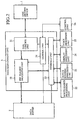
- Fig. 1 is a block diagram showing the configuration of a navigation device according to the first embodiment of the invention
- Fig. 2 a block diagram showing the constitution of a data management unit 3 shown in Fig. 1.
- a reference numeral 1 denotes a disk driving device, which can be loaded with a compact disc-read only memory (CD-ROM) such as a map recording medium 101 for recording map data containing road map information, guiding information of each point, and so on, a music recording medium 102 for recording music data, a video recording medium 103 for recording video data or the like, or a digital versatile disc-read only memory (DVD-ROM), and reads data therefrom; and 2 a data buffer for storing the pre-read map data.
- CD-ROM compact disc-read only memory
- a reference numeral 3 denotes a data management unit for managing various data in the manner of reading various data including map data, and so on, from the map recording medium 101 by controlling the disk driving device 1, and storing the pre-read map data in the data buffer 2.
- the data management unit 3 shown in Fig.2 includes the following components: a disk control unit 31 for reading data from a loaded recording medium by directly controlling the disk driving device 1; a pre-reading processing unit 32 for storing, among the data read by the disk control unit 31, map data to be pre-read into the data buffer 2, and supplying the other data to an interface unit 33; the interface unit 33 for supplying the data from the pre-reading processing unit 32 and the map data from the data buffer 2 to any one of a route search processing unit 22, a route guiding processing unit 23, a display processing unit 24 and a voice processing unit 25; and a control (calculation) unit 34 for controlling each unit in such a manner as to transfer and/or receive a control signal to and/or from a control signal with the control unit 26 of a navigation function unit 4, supplying a control signal for pre-reading to the pre-reading processing unit 32, supplying a control signal to the data buffer 2 for outputting, at a proper time, the map data pre-read and stored in the data buffer 2 in this case, and
- the navigation function unit denoted by 4 is provided to search, among various data managed by the data management unit 3, a route to a destination set by a user based on the map data, generate a guiding image or voice for guiding the route, and reproduce voice or video data.
- the navigation function unit 4 includes the following components: a present position detection unit 21 for detecting a present position based on bits of information obtained by a GPS receiver 5, a vehicle information sensor 6 and a gyro 7; a route search processing unit 22 for searching the route to the destination set by the user based on the detected present position; a route guiding processing unit 23 for generating data of a guiding image or voice for rough guiding of the searched entire route or guiding in the vicinity of the present position in the searched route based on the map data; a display processing unit 24 for receiving the guiding image data or video data, and image data indicating the quantity or rate of the pre-read map data, and outputting an image signal corresponding to the supplied data to a display 10; a voice processing unit 25 for receiving guiding voice data or music data, and voice data indicating the quantity or rate of the pre-read map data, and outputting a voice signal corresponding to the supplied data to a speaker 9; and a control unit 26 for executing each of various operations in accordance with a program pre
- a reference numeral 5 denotes a GPS receiver for receiving a radio wave from a GPS satellite; 6 a vehicle information sensor for obtaining vehicle information such as a car speed; and 7 a gyro.
- a reference numeral 8 denotes a remote controller for performing various operations by the user; 9 a speaker (notification unit) for outputting a voice corresponding to a voice signal from the voice processing unit 25, and 10 a display (notification unit) for displaying an image corresponding to an image signal from the display processing unit 24.
- the control unit 26 of the navigation function unit 4 starts a navigation service to the destination.
- control unit 26 of the navigation function unit 4 instructs the control unit 34 of the data management unit 3 to read, from the map recording medium 101, map data necessary for searching a rough route from a present position to the destination.
- the control unit 34 of the data management unit 3 instructs the disk control unit 31 to read the map data, instructs the pre-reading processing unit 32 to supply the read map data to the interface unit 33, and then instructs the interface unit 33 to supply the received map data to the route search processing unit 22.
- map data necessary for searing the rough route from the present position to the destination is supplied from the map recording medium 101 to the route search processing unit 22 of the navigation function unit 4.
- the route search processing unit 22 of the navigation function unit 4 searches the rough route from the present position to the destination based on the map data. After the completion of the searching of the rough route from the present position to the destination, the route search processing unit 22 supplies the data of the rough route to the route guiding processing unit 23. Then, the route guiding processing unit 23 generates a guiding image data for guiding the rough route, supplies the data to the display processing unit 24, and displays the guiding image on the display 10.
- the control unit 26 of the navigation function unit 4 instructs the control unit 34 of the data management unit 3 to pre-read detailed reduced-scale map data necessary for guiding at each point and accompanying data (e.g., data containing information about buildings around the road) from the map recording medium 101 when the vehicle travels ahead along the rough route.
- This instruction may be issued when the searching of the rough route is completed, or as one for pre-reading a route up to an already established point.
- the pre-reading processing unit 31 pre-reads the map data necessary for route guiding from the map recording medium 101 in the period of non-reading of map data necessary at present.
- the control unit 34 of the data management unit 3 instructs the reading of map data to the disk control unit 3, and then instructs the pre-reading processing unit 32 to pre-read and store the read map data in the data buffer 2.
- the detailed reduced-scale map data necessary for guiding when the vehicle travels ahead along the rough route, and the accompanying data thereof are sequentially pre-read along the rough route and stored in the data buffer 2.
- the control unit 34 of the data management unit 3 notifies the quantity of the map data, whose pre-reading has been completed, or the rate of the map data, whose pre-reading has been completed, to all the map data to be pre-read, to the control unit 26 of the navigation function unit 4 at proper time.
- the quantity of map data, the pre-reading thereof having been completed the quantity of map data from the starting point of the route to a point already pre-read, or the quantity of map data from the present position to the point already pre-read may be used. These can be selective.
- the control unit 26 of the navigation function unit 4 Upon having received the quantity or rate of the map data, whose pre-reading has been completed, the control unit 26 of the navigation function unit 4 generates an image data for notifying the quantity or rate of the map data, whose pre-reading has been completed, and supplies the thus made image data to the display processing unit 24, and then displays the image on the display 10.
- the control unit 26 of the navigation function unit 4 receives the quantity or rate of the pre-read map data, then generates voice data for notifying the quantity or rate of the pre-read map data, and supplies the thus made voice data to the voice processing unit 25, and then outputs the voice to the speaker 9.
- the user knows a progress in the pre-reading operation by the image or the voice, and instructs the pre-reading operation to be interrupted or terminated by a manual operation of the remote controller 8.
- the recording medium can be switched to another one.
- the map recording medium 101 for route guiding is no longer necessary.
- the map recording medium 101 loaded in the disk driving device 1 can be switched to another recording medium.
- control unit 26 of the navigation function unit 4 instructs the control unit 34 of the data management unit 3 to supply the map data stored in the data buffer 2 to the route guiding processing unit 23.
- the control unit 34 instructs the data buffer 2 to supply the pre-read map data to the interface unit 33, and then instructs the interface unit 33 to supply the map data to the route guiding processing unit 23. Accordingly, the map data pre-read and stored in the data buffer 2 is supplied to the route guiding processing unit 23 as occasion demands.
- the route guiding processing unit 23 generates image or voice data for guiding around the present position based on the map data, supplies the image data to the display processing unit 24, and displays the image on the display 10.
- the voice data is supplied to the voice processing unit 25, and the voice is outputted to the speaker 9.
- the route guiding is performed by repeating the foregoing processing until the vehicle reaches the destination.
- the route guiding is executed based on the pre-read map data, after the completion of pre-reading, the user can enjoy music or a video by switching a recording medium to, for example the music recording medium 102 or the video recording medium 103 while receiving route guiding.
- the control unit 26 of the navigation function unit 4 instructs the control unit 34 of the data management unit 3 to read the music data or the video data.
- the control unit 34 of the data management unit 3 instructs the disk control unit 31 to read the music data or the video data.
- the pre-reading processing unit 32 is instructed to directly supply the music data or the video data to the interface unit 33.
- the interface unit 33 is instructed to supply, among such data, the image data to the display processing unit 24, and the voice data to the voice processing unit 25.
- the display processing unit 24 of the navigation function unit 4 displays an image corresponding to the image data on the display 10, and the voice processing unit 25 outputs a voice corresponding to the voice data to the speaker 9.
- the image of the route guiding and the image of the video data are simultaneously displayed on the display 10 by, for example dividing the screen.
- the image of the route guiding may be displayed by being superposed on the image of the video data only when the image of the route guiding is displayed.
- the quantity or rate of the pre-read map data for route guiding is notified.
- the user can know a progress in the pre-reading operation of the map data, and instruct the pre-reading operation to be interrupted or terminated as occasion demands. It is therefore possible to enhance convenience.
- the map data necessary for route guiding is pre-read from the map recording medium 101 in the period of non-reading of map data necessary at present.
- pre-reading processing without interrupting the reading of map data for currently executed processing.
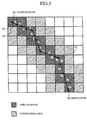
- Fig. 3 is a view illustrating the calculation regarding the progress in the pre-reading operation of map data in a navigation device according to the second embodiment of the invention.
- the control unit 34 of the data management unit 3 instructs the disk control unit 31 and the pre-reading processing unit 32 to pre-read map data of an area en route to the destination , and its surrounding area as map data necessary for route guiding.
- the map recording medium 101 a wide area has been divided into areas of predetermined sizes, and map data has been recorded for each area.
- the control unit 34 of the data management unit 3 calculates the distance of a route up to the pre-read area as a quantity of pre-read map data.
- the control unit 34 calculates a sum of distances between joints 64 on the route as a distance on the route. For example, in Fig. 3, assuming that pre-reading up to an area 71 en route to the destination has been completed, a total sum of lengths L1 to L13 of a road link 63 from a starting point 61 to a joint near the destination 62 of the area 71 is calculated as a value to represent the quantity of the pre-read map data.
- the - map data of the area en route to the destination and its surrounding area are pre-read.
- the vehicle moves away from the searched route and enters a surrounding area, it is possible to continue route guiding only based on the pre-read map data without needing the map recording medium 101.
- the distance of a route up to the pre-read area is calculated as the quantity of pre-read map data. This arrangement enables the user to know how far the route guiding can be performed without the map recording medium 101.
- a ratio between the distance of the route up to the pre-read area and the distance of the entire route is calculated as a rate of pre-read map data.
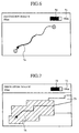
- Fig. 4 shows an example of displaying regarding the progress in the pre-reading operation of map data in a navigation device according to the third embodiment of the invention.
- the control unit 26 of the navigation function unit 4 upon having received the quantity or rate of map data, whose pre-reading operation has been completed, for example as shown in Fig. 4, the control unit 26 of the navigation function unit 4 generates image data of a numerical value 71 (35 km in the described case) for notifying the quantity of the pre-read map data, and image data of a meter 72 indicative of the rate of the pre-read map data, and supplies these data to the display processing unit 24. Then, the images thereof are displayed on predetermined display areas of the display 10.
- the quantity or rate of the pre-read map data is displayed by the numerical value 71 or the meter 72. This arrangement enables the user to intuitively know how far route guiding can be performed without the map recording medium 101.
- Fig. 5 shows an example of displaying regarding the progress in the pre-reading operation of map data in the navigation device according to the fourth embodiment of the invention.
- the control unit 26 of the navigation function unit 4 upon having received the quantity or rate of map data, whose pre-reading operation has been completed, for example as shown in Fig. 5, in order to notify the quantity of the pre-read map data, along the image of a searched route, the control unit 26 of the navigation function unit 4 generates image data of a line 74 different from the route image in color and thickness, indicative of the quantity of the pre-read map data, and supplies the image data to the display processing unit 24, and then the image is displayed in a -predetermined display area of the display screen of the display 10.
- the quantity or rate of the pre-read map data is displayed along the displaying of the route. This arrangement enables the user to intuitively know how far route guiding can be performed without the map recording medium 101.
- Fig. 6 shows an example of displaying regarding the progress in the pre-reading of map data in a navigation device according to the fifth embodiment of the invention.
- the route guiding processing unit 23 of the navigation function unit 4 generates data of a route outline image indicative of a distance between main points, and supplies the data to the display processing unit 24, and then the image is displayed on the display 10.
- the control unit 26 Upon having received the quantity or rate of map data, whose pre-reading operation has been completed, for example as shown in Fig. 6, in order to notify the quantity of the pre-read map data, the control unit 26 generates data of an image of a bar 73 indicative of the quantity or rate of the pre-read map data, and supplies the image to the display processing unit 24. Then, the image is displayed by being superposed on the route outline image displayed on the display 10.
- the quantity or rate of the pre-read map data is displayed along the displaying of the route (route outline image in the described case). This arrangement enables the user to intuitively know how far the route guiding can be performed without the map recording medium 101.
- Fig. 7 shows an example of displaying regarding the progress in the pre-reading operation of map data in a navigation device according to the sixth embodiment of the invention.
- the control unit 26 of the navigation function unit 4 instructs the route guiding processing unit 23 to generate data of map images different in color between a non pre-read area 75 and a pre-read area 76, and supply the data to the display processing unit 24. Then, the map images are displayed on the display 10.
- the quantity or rate of the pre-read map data is notified by displaying the map images different in color between the non pre-read area 75 and the pre-read area 76. This arrangement enables the user to intuitively know how far the route guiding can be performed without the map recording medium 10.
- the display area for displaying the quantity or rate of the pre-read map data may be used for displaying other data. Therefore, it is possible to effectively use the display screen of the display 10.
- the navigation device loaded on a vehicle is suitably used for providing route guiding to a driver.
Landscapes
- Engineering & Computer Science (AREA)
- Radar, Positioning & Navigation (AREA)
- Remote Sensing (AREA)
- Physics & Mathematics (AREA)
- Theoretical Computer Science (AREA)
- General Physics & Mathematics (AREA)
- Mathematical Physics (AREA)
- Automation & Control Theory (AREA)
- Business, Economics & Management (AREA)
- Educational Administration (AREA)
- Educational Technology (AREA)
- Navigation (AREA)
- Instructional Devices (AREA)
Abstract
Description
Claims (13)
- A navigation device for reading map data from a recording medium, searching a route to a destination based on the map data, and then providing guiding along the route, comprising:a route search processing unit (22) for searching the route to the destination based on the map data;a pre-reading processing unit (32) for pre-reading the map data necessary for route guiding from the recording medium;a route guiding processing unit (23) for providing a guiding of the route to the destination based on the map data;a calculation unit (34) for calculating a quantity or rate of the map data pre-read by said pre-reading processing unit; anda notification unit (10) for notifying the quantity or rate of the map data pre-read by said pre-reading processing unit.
- The navigation device according to claim 1,
wherein as the map data necessary for route guiding, said pre-reading processing unit pre-reads map data on an area en route to the destination and a surrounding area thereof. - The navigation device according to claim 1,
wherein said calculation unit (34) calculates a distance of a route to a pre-read area as a quantity of the pre-read map data. - The navigation device according to claim 3,
wherein said calculation unit (34) calculates a sum of distances between joints on the route as a distance on the route. - The navigation device according to claim 1,
wherein said calculation unit (34) calculates a ratio of a distance of a route up to the pre-read area and a distance of a total route as a rate of the pre-read map data. - The navigation device according to claim 1,
wherein said pre-reading processing unit (32) pre-reads the map data necessary for route guiding during the period of non-reading of map data necessary at present. - The navigation device according to claim 1,
wherein said calculation unit (34) calculates a quantity or rate of map data from a starting point of the route to a pre-read point. - The navigation device according to claim 1,
wherein said calculation unit (34) calculates a quantity or rate of map data from a present position to a pre-read point. - The navigation device according to claim 1,
wherein said notification unit (10) displays the quantity or rate of the pre-read map data by numerical values. - The navigation device according to claim 1,
wherein said notification unit (10) displays the quantity or rate of the pre-read map data by meters. - The navigation device according to claim 1,
wherein said notification unit (10) displays the quantity or rate of the pre-read map data along the displayed route. - The navigation device according to claim 1,
wherein said notification unit (10) notifies the quantity or rate of the pre-read map data by displaying map images between a non pre-read area and a pre-read area, different in color from each other . - The navigation device according to claim 1,
wherein said notification unit (10) uses an area of displaying the quantity or rate of the pre-read map data for displaying other data during route searching by said route search processing unit.
Applications Claiming Priority (1)
| Application Number | Priority Date | Filing Date | Title |
|---|---|---|---|
| PCT/JP2000/003699 WO2001094889A1 (en) | 2000-06-07 | 2000-06-07 | Navigation apparatus |
Publications (3)
| Publication Number | Publication Date |
|---|---|
| EP1288616A1 true EP1288616A1 (en) | 2003-03-05 |
| EP1288616A4 EP1288616A4 (en) | 2003-08-13 |
| EP1288616B1 EP1288616B1 (en) | 2008-10-29 |
Family
ID=11736127
Family Applications (1)
| Application Number | Title | Priority Date | Filing Date |
|---|---|---|---|
| EP00935574A Expired - Lifetime EP1288616B1 (en) | 2000-06-07 | 2000-06-07 | Navigation apparatus |
Country Status (5)
| Country | Link |
|---|---|
| US (1) | US6681178B1 (en) |
| EP (1) | EP1288616B1 (en) |
| JP (1) | JP3844735B2 (en) |
| DE (1) | DE60040690D1 (en) |
| WO (1) | WO2001094889A1 (en) |
Families Citing this family (6)
| Publication number | Priority date | Publication date | Assignee | Title |
|---|---|---|---|---|
| IES20010399A2 (en) * | 2000-05-16 | 2002-02-06 | Richmount Computers Ltd | A protocol for a power supply unit controller |
| JPWO2005033953A1 (en) * | 2003-09-30 | 2006-12-14 | ソニー株式会社 | Data display controller |
| JP2005140676A (en) * | 2003-11-07 | 2005-06-02 | Mitsubishi Electric Corp | Navigation system |
| JP5070421B2 (en) * | 2007-05-21 | 2012-11-14 | 株式会社ジオ技術研究所 | Map display device |
| US20090254265A1 (en) * | 2008-04-08 | 2009-10-08 | Thimmannagari Chandra Reddy | Video map technology for navigation |
| KR102222250B1 (en) * | 2014-08-12 | 2021-03-04 | 삼성전자주식회사 | Method and Apparatus for Providing Route Guidance using Reference Points |
Family Cites Families (12)
| Publication number | Priority date | Publication date | Assignee | Title |
|---|---|---|---|---|
| US4393443A (en) * | 1980-05-20 | 1983-07-12 | Tektronix, Inc. | Memory mapping system |
| JPH0470998A (en) | 1990-07-04 | 1992-03-05 | Nissan Motor Co Ltd | On-vehicle navigator |
| JP3038868B2 (en) * | 1990-10-08 | 2000-05-08 | ソニー株式会社 | Image data block transfer device |
| JPH06117866A (en) | 1992-10-01 | 1994-04-28 | Fujitsu Ten Ltd | Displaying device for running information of vehicle |
| DE69625142T2 (en) * | 1995-09-08 | 2003-04-24 | Aisin Aw Co., Ltd. | Car navigation system |
| JP3594374B2 (en) | 1995-09-29 | 2004-11-24 | 松下電器産業株式会社 | Navigation device |
| US5918246A (en) * | 1997-01-23 | 1999-06-29 | International Business Machines Corporation | Apparatus and method for prefetching data based on information contained in a compiler generated program map |
| JPH1165430A (en) | 1997-08-19 | 1999-03-05 | Matsushita Electric Ind Co Ltd | Map zooming display method, map zooming display device, and computer for map zooming display device |
| JP3621572B2 (en) | 1997-12-11 | 2005-02-16 | 文雄 溝口 | Map data prefetching method and map scrolling method |
| CA2316239A1 (en) | 1997-12-24 | 1999-07-08 | Avid Technology, Inc. | Computer system and process for transferring multiple high bandwidth streams of data between multiple storage units and multiple applications in a scalable and reliable manner |
| JP2000083068A (en) * | 1998-06-09 | 2000-03-21 | Matsushita Electric Ind Co Ltd | Data output device |
| JP3324572B2 (en) * | 1999-03-30 | 2002-09-17 | 三菱電機株式会社 | Information processing apparatus and recording medium recording program to be executed by computer |
-
2000
- 2000-06-07 DE DE60040690T patent/DE60040690D1/en not_active Expired - Lifetime
- 2000-06-07 US US10/030,816 patent/US6681178B1/en not_active Expired - Fee Related
- 2000-06-07 JP JP2002502393A patent/JP3844735B2/en not_active Expired - Fee Related
- 2000-06-07 WO PCT/JP2000/003699 patent/WO2001094889A1/en not_active Ceased
- 2000-06-07 EP EP00935574A patent/EP1288616B1/en not_active Expired - Lifetime
Also Published As
| Publication number | Publication date |
|---|---|
| EP1288616B1 (en) | 2008-10-29 |
| DE60040690D1 (en) | 2008-12-11 |
| US6681178B1 (en) | 2004-01-20 |
| EP1288616A4 (en) | 2003-08-13 |
| WO2001094889A1 (en) | 2001-12-13 |
| JP3844735B2 (en) | 2006-11-15 |
Similar Documents
| Publication | Publication Date | Title |
|---|---|---|
| JP5299995B2 (en) | Map display device | |
| US8983769B2 (en) | Map information processing apparatus | |
| JP5035842B2 (en) | Navigation device | |
| US6658352B2 (en) | Navigation system | |
| US7463978B2 (en) | Navigation apparatus and map-indication control program | |
| EP1288616B1 (en) | Navigation apparatus | |
| JP3008839B2 (en) | Navigation device | |
| JP4391758B2 (en) | Car navigation system | |
| US6704647B1 (en) | Navigation system | |
| JPWO2001094889A1 (en) | navigation device | |
| JP2005009991A (en) | On-vehicle navigation apparatus, and display method for on vehicle navigation apparatus | |
| JP2001165674A (en) | Navigation device | |
| JP2010286944A (en) | Drive recorder system, constant-recording type drive recorder, and navigation device | |
| JP4499586B2 (en) | Image correction system and image correction method | |
| JP4180471B2 (en) | Navigation system | |
| JP4439318B2 (en) | Navigation device and road display method | |
| JP4482960B2 (en) | Navigation method and apparatus | |
| JPH1114382A (en) | Electronic map drawing method and navigation device | |
| JP5005454B2 (en) | On-vehicle navigation device and minute angle branch determination method | |
| JP4900599B2 (en) | Navigation device | |
| JP4628796B2 (en) | Navigation device | |
| JP3881233B2 (en) | Navigation device | |
| JP2009098011A (en) | Navigation system | |
| JP4658733B2 (en) | Frame acquisition device and vehicle-mounted navigation device | |
| JP4532217B2 (en) | Navigation device, method and program |
Legal Events
| Date | Code | Title | Description |
|---|---|---|---|
| PUAI | Public reference made under article 153(3) epc to a published international application that has entered the european phase |
Free format text: ORIGINAL CODE: 0009012 |
|
| 17P | Request for examination filed |
Effective date: 20020123 |
|
| AK | Designated contracting states |
Designated state(s): AT BE CH CY DE DK ES FI FR GB GR IE IT LI LU MC NL PT SE Kind code of ref document: A1 Designated state(s): AT BE CH CY DE DK ES FI FR GB GR IE IT LI LU MC NL PT SE |
|
| A4 | Supplementary search report drawn up and despatched |
Effective date: 20030626 |
|
| RIC1 | Information provided on ipc code assigned before grant |
Ipc: 7G 01C 21/26 A Ipc: 7G 01C 21/36 B Ipc: 7G 08G 1/0969 B |
|
| RBV | Designated contracting states (corrected) |
Designated state(s): DE |
|
| RAP1 | Party data changed (applicant data changed or rights of an application transferred) |
Owner name: MITSUBISHI DENKI KABUSHIKI KAISHA |
|
| GRAP | Despatch of communication of intention to grant a patent |
Free format text: ORIGINAL CODE: EPIDOSNIGR1 |
|
| GRAS | Grant fee paid |
Free format text: ORIGINAL CODE: EPIDOSNIGR3 |
|
| GRAA | (expected) grant |
Free format text: ORIGINAL CODE: 0009210 |
|
| AK | Designated contracting states |
Kind code of ref document: B1 Designated state(s): DE |
|
| REF | Corresponds to: |
Ref document number: 60040690 Country of ref document: DE Date of ref document: 20081211 Kind code of ref document: P |
|
| PLBE | No opposition filed within time limit |
Free format text: ORIGINAL CODE: 0009261 |
|
| STAA | Information on the status of an ep patent application or granted ep patent |
Free format text: STATUS: NO OPPOSITION FILED WITHIN TIME LIMIT |
|
| 26N | No opposition filed |
Effective date: 20090730 |
|
| REG | Reference to a national code |
Ref country code: DE Ref legal event code: R084 Ref document number: 60040690 Country of ref document: DE |
|
| PGFP | Annual fee paid to national office [announced via postgrant information from national office to epo] |
Ref country code: DE Payment date: 20120530 Year of fee payment: 13 |
|
| REG | Reference to a national code |
Ref country code: DE Ref legal event code: R119 Ref document number: 60040690 Country of ref document: DE Effective date: 20140101 |
|
| PG25 | Lapsed in a contracting state [announced via postgrant information from national office to epo] |
Ref country code: DE Free format text: LAPSE BECAUSE OF NON-PAYMENT OF DUE FEES Effective date: 20140101 |