<Technical Field>
The present invention relates to a system for providing
updating information of a position information identifier, which
defines a road position, to an on-board device or the like, a method
for transmitting the position information identifier in that case,
and a device for executing the method. More particularly, the
invention aids a system for providing traffic information by using
the position information identifier.
<Background of the Invention>
Recently, the vehicle carrying thereon an on-board
navigation device rapidly increases its number. The on-board
navigation device contains digital map database, and receives
information by a VICS (vehicle information communication system) ,
which provides traffic congestion information or traffic accident
information, through media such as FM multiplex broadcasting, or
radio or optical beacon, displays a congested or accident position
on a map, and adds those pieces of information to the condition
and executes a route search process based on the condition.
The digital map database is currently prepared by several
companies in Japan. The map data contains errors as the fatality
of the scale map. Those errors contained in the map data are
different for each company.
In the transmission of traffic information, e.g., the
position of a traffic accident on the on-board navigation device,
if the longitude and latitude data representative of that position
is solely presented, the on-board navigation device mistakenly
recognizes a position on a different road as the accident position,
depending on some types of the digital map database contained
therein.
To avoid such an unexactness of the information
transmission, in the VICS information, road positions are
designated by using position information identifiers, such as node
numbers assigned to nodes, e.g., intersections, link numbers
assigned to the links each between adjacent nodes or the like.
In the digital map database of every company, the intersections
and roads are stored in association with node numbers and link
numbers. Accordingly, each road position described in terms of
the VICS information may uniquely be specified.
The position information identifier is defined according
to predetermined rules. As shown in Fig. 14(a), each node has
a node number, which is uniquely assigned to and indicates the
node. A link number of a road "c" located between a node "a" (node
number = 1111) and another node "b" (node number = 3333) is assigned
"11113333" in which the large node number "3333" follows the small
node number "1111". A curve of the road is approximated by a
polygonal line, apexes of the polygonal line are set as
interpolating points, the node "a" of the small node number is
designated as an interpolating point (1), and the node "b" is
designated as the final interpolating point, and the interpolating
points located between the nodes "a" and "b" are sequentially
numbered.
As shown in Fig. 14(b), in a case where a new road is
constructed and another node "d" (node number = 4444) is provided
anew, the old link number "11113333" is substituted by a new line
number 11114444 assigned to a link "f" between the nodes "a" and
"d", and another new link number "33334444" assigned to a link
"e" between the nodes "d" and "b".
Updating information of the position information
identifier is recorded into a recording medium, and distributed
to the related map data manufacturing companies, from a
distribution source. Each company modifies the company's map data
on the basis of the updated position information identifier. Some
companies accept a customer's request of modifying the map data
as the after-sales service to the map data sold.
In the VICS information, even after the position
information identifier is updated, traffic information containing
both the position information identifier after updated and the
position information identifier before updated is provided for
a predetermined period of time, while taking the on-board
navigation devices containing the digital map data before updated
into consideration.
Road construction and alteration will be carried out
continuously in the future, and the position information identifier
will be updated repeatedly. Accordingly, the money as invested
into the maintenance and after-sales service by the map data
manufacturers, is extremely large.
In the VICS information, it is necessary to send the new
and old position information identifiers redundantly. Therefore,
to maintain the information providing system, which utilizes the
position information identifiers, much cost is taken in various
forms, such as economic burden to prepare its data, and data
transmission inefficiency.
Accordingly, an object of the present invention is to
provide a system for aiding the information providing service
utilizing the position information identifiers, and a method and
apparatus for transmitting position information identifiers in
that system.
<DISCLOSURE OF THE INVENTION>
According to one aspect of the invention, there is provided
a position information identifier providing system, which
includes:
According to another aspect of the invention, there is
provided a method for transmitting to a receiving device containing
a database of position information identifiers and a database of
a digital map, information on said position information identifier
as updated,
wherein
According to still another aspect, there is provided a
position information identifier transmitter for generating and
transmitting position information identifier transmitting
information containing information on a position information
identifier and coordinate row information of nodes and
interpolating points, both constituting said position information
identifier.
According to still another aspect of the invention, there
is provided a receiving device which contains a database on a
position information identifier and a database on a digital map,
and receives information using said position information
identifier and displays a position on a digital map, which
corresponds to said position information identifier, the
improvement being characterized in that
The system of the invention is capable of supplementarily
supporting a scheme of providing information by using the position
information identifier. The burden imposed on the map data
manufacturer, such as the maintenance and after-sales service,
which result from the updating of the position information
identifier, is lightened. Further, there is no need of
transmitting the new and old position information identifiers
redundantly to the VICS information.
Where the position information identifier transmitting
method of the invention is employed, if different digital map data
is used, the receiving side device reliably makes the
correspondence between the position information identifier and
the position on the digital map.
<BRIEF DESCRIPTION OF THE DRAWINGS>
Fig. 1 is a block diagram showing an arrangement of a
position information identifier providing system, which is an
embodiment of the present invention,
Fig. 2 is a diagram showing a data configuration of position
information identifier information provided in the embodiment
system,
Fig. 3 is a diagram showing a data configuration of
supplementary information provided in the embodiment system,
Fig. 4 is a diagram showing a data configuration of accident
information, which is provided as traffic information in the
embodiment system,
Fig. 5 is a diagram showing a data configuration of traffic
congestion information, which is provided as traffic information
in the embodiment system,
Fig. 6 is a flow chart showing operations at respective
portions in the embodiment system,
Fig. 7 is a diagram showing a first application of the
embodiment system,
Fig. 8 is a diagram showing a second application of the
embodiment system,
Fig. 9 is a diagram showing a third application of the
embodiment system,
Fig. 10 is a diagram showing a position information
identifier in the embodiment system,
Fig. 11 is a diagram showing another position information
identifier in the embodiment system,
Fig. 12 is a diagram showing yet another position
information identifier in the embodiment system,
Fig. 13 is a diagram showing an application other than
the transmission of the updated position information identifier
in the embodiment system, and
Figs. 14(a) and 14(b) are diagrams for explaining the
updating of the position information identifier.
<BEST MODES FOR CARRYING OUT THE INVENTION>
A system of an embodiment according to the invention, as
shown in Fig. 1, is made up of media 20 for providing various pieces
of traffic information by using position information identifiers,
a position information identifier transmitting device 10 for
providing information of the position information identifiers per
se, and a receiving side device 30 which receives traffic
information from the media 20 and receives position information
identifier information from the position information identifier
transmitting device 10.
The position information identifier transmitting device
10 includes a new position information identifier database A 11,
a digital map database A 12, a position information identifier
transmitting information generating part 13 for generating
transmitting information of position information identifiers, and
a position information identifier information transmitting part
14 for transmitting generated information of position information
identifiers.
The receiving side device 30 includes a position
information identifier database B 37, a digital map database B
38, a position information identifier information receiving part
31 which receives position information identifier information from
the position information identifier transmitting device 10, an
information reflection judging part 32 which judges the position
information identifiers and selects those position information
identifiers needed by the receiver unit, a map matching part 33
which executes a map matching process to determine a position of
the position information identifier on the digital map, traffic
information receiving parts 34, 35 and 36 for receiving traffic
information from media, a traffic-information generating position
computing part 39 which computes a position where an event, such
as traffic accident or traffic congestion, occurs, from the
information received, and a digital map display part 40 which
displays the position where the event occurs.
The receiving side device 30 is mounted on a vehicle.
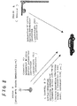
Traffic information are provided by media, such as a traffic
information providing channel (channel A) of ground wave digital
broadcasting as shown in Fig. 7 and a beacon as shown in Fig. 8.
Information on the position information identifier is provided
by a position information identifier information providing channel
(channel B) of the ground wave digital broadcasting, for example.
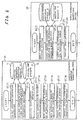
Fig. 6 shows operating procedures of the position
information identifier transmitting device 10, the traffic
information transmitting device 20 and the receiving side device
30.
The following operation is performed in the position
information identifier transmitting device 10.
Step 11: The position information identifier
transmitting information generating part 13 selects a new position
information identifier (e.g., link data) from the position
information identifier database A 11, or selects information of
an position information identifier containing a position of or
designated by the receiver unit.
Step 12: The position information identifier
transmitting information generating part acquires coordinate
values (longitude/latitude) of nodes and interpolating points,
which constitute the position information identifier, from the
digital map database A 12, and generates a coordinate row.
Step 13: The position information identifier
transmitting information generating part further acquires
supplementary information indicating the attributes of the nodes
and the links each between adjacent nodes, from the digital map
database A 12. The supplementary information includes
information on road type code, road number, the number of connection
links at the intersection node, and connection link angles of the
connection links and others.
Step 14: When a configuration of an array of
interpolating points may be approximated by a function, the array
configuration is expressed by the function, whereby the coordinate
row data is compressed.
Step 15: When the interpolating points are
linearly arrayed, the interpolating points are thinned to compress
the coordinate row data.
Step 16: The coordinate value of the first node
in the coordinate row is expressed by the absolute coordinate.
The coordinate values of the second and subsequent nodes (or
interpolating points) are expressed, to compress the data amount,
by the relative coordinate in a manner that a difference between
the coordinate value of the first node and the coordinate value
of the preceding node (or the interpolating point) .
Step 17: Information (link number) of the
position information identifier and information of the coordinate
row or the supplementary information are formatted into a
transmission format.
Step 18: The position information identifier
information transmitting part 14 transmits this data.
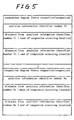
Fig. 2 exemplarily shows a data configuration of the
position information identifier information, and the added road
information is exemplarily shown.
The receiving side device 30 which has received the position
information identifier information and the supplementary
information performs following operation.
Step 31: The position information identifier
information receiving part 31 receives the data.
Step 32: The information reflection judging part
32 compares the received data with the position information
identifiers stored in the position information identifier database
B 37, and selects the position information identifier to be updated
from the received data, and stores the selected position
information identifier into the position information identifier
database B 37.
In this case, when the received information is not contained
in the position information identifier database, or when the
received information is newer than the data stored in the self
device, the received position information identifier may be stored
in the position information identifier database B 37.
Step 33: The map matching part 33 carries out a
map matching process of the data of the coordinate row contained
in the position information identifier information to the data
of the digital map database B 38 to thereby determine a position
of the position information identifier on the digital map. At
this time, the map matching part makes a short list of candidate
points of the position information identifier positions by
referring to the supplementary information , azimuth information
of the nodes contained in the position information identifier
information, height information and the like.
Step 34: The information reflection judging part
32 associates the previously stored position information
identifier with the position on the digital map, which is determined
by the map matching part.
In this way, data of the new position information identifier
is stored into the position information identifier database B 37.
The traffic information transmitting device 20 provides
traffic information in the following procedure.
Step 21: Position where an event, such as traffic
congestion or traffic accident, occurs, is entered.
Step 22: A relative distance (relative position)
to the event occurring position is computed using a position
information identifier (link number) of the road where the event
occurs, and the nodes.
Step 23: A format of those pieces of position
information is converted to a transmission format.
Step 24: The information transmission formatted
is then transmitted in the form of event information.
Fig. 4 shows event information presented when a traffic
accident occurs, and Fig. 4 shows event information presented at
the time of traffic congestion.
The receiving side device 30 that receives the event
information operates in the following way.
Step 41: The traffic information receiving parts
34 to 36 receive the event information.
Step 42: The traffic-information generating
position computing part 39 specifies a road on the digital map,
which contains an event occurring position, by using the position
information identifier contained in the event information and the
data of the position information identifier database B 37 and the
digital map database B 38, and specifies the event occurring
position on the road based on a relative position contained in
the event information.
Step 43: The event occurring position is visually
presented on the map displayed in the digital map display part
40.
Thus, in this system, the position information identifiers
stored in the receiving side device are automatically updated
according to the information from the position information
identifier transmitter 10, and the newest position information
identifier is stored in the receiving side device. For this reason,
the traffic information transmitting device is able to provide
traffic information by using only the newest position information
identifier.
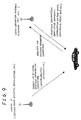
Also in the system, as shown in Fig. 9, the information
of the position information identifier may be received from other
media than the media providing traffic information, by way of a
portable telephone set. In this case, when the position
information identifier, which is not found in the self position
information identifier database B 37, is contained in the traffic
information, the receiving side device requests the position
information identifier providing media to send the position
information identifier, by way of the portable telephone set. Upon
receipt of this, the position information identifier providing
media sends the requested position information identifier to the
receiving side device.
Some examples of the position information identifiers are
presented:
The intersections per se are numbered, and the road interval
is expressed by using two numbers.
How to display the traffic congestion information in Figs.
10 to 12 will be described. When the "position information
identifier 1" (Fig. 10) is used, the congestion information is
displayed as "position information identifier is 214,and the
conjested block is 250m to 450m". When the "position information
identifier 2" (Fig. 11) is used for displaying the same information,
its display is "the position information identifier is 54, the
direction is the reverse direction, and the conjested block is
250m to 450m".
When the same information is displayed by using the
"position information identifier " (Fig. 12), the display is "the
position information identifier is 312 to 355, and the conjested
block is 250m to 450m".
An application other than the transmission of the updated
position information identifier in the embodiment system, is shown
in Fig. 13.
In this example, at the start, the on-board navigation
device contains only the digital map, and it sends, as needed,
necessary information to a currently traveling area (further it
may be what is obtained by extracting only the links from the
information provided). Subsequently, the vehicle carrying the
on-board navigation device further travels, and the vehicle's
position changes with its traveling. The position information
identifier is updated with the changing vehicle's position.
In a specific example, a vehicle which holds only the
digital map information at the time of its starting, starts from
a location in the Tokyo Metropolitan area, in a state that it is
not loaded with the position information identifier. During its
traveling in the Tokyo Metropolitan area, the vehicle receives
the position information identifiers in the Metropolitan area,
and traffic information in the same area. When the vehicle further
travels and enters the Kanagawa prefecture area, the vehicle
receives the position information identifiers in the Kanagawa
prefecture area and traffic information in the same area.
While the present invention has been described in detail
and using a specific embodiment, it should be understood that the
invention may variously be modified, altered and changed within
the true spirits and scope of the invention.
This application is based on Japanese Patent Application
(Application No. 2000-375321), filed Dec. 8, 2000, the content
of which is incorporated herein by reference.
<Industrial Applicability>
As seen from the foregoing description, the system of the
invention is capable of supplementarily supporting a scheme of
providing information by using the position information
identifiers, and lightening the burden imposed on the map data
manufacturer in order to maintain the scheme of providing
information.
Further, there is no need of transmitting the new and old
position information identifiers redundantly to the VICS
information. Accordingly, the efficiency of the data
transmission is improved, and the resultant energy may be used
for enriching the information service.
Where the position information identifier transmitting
method of the invention is employed, the receiving side device
reliably makes the correspondence between the position information
identifier and the position on the digital map even if different
digital map data is used.