EP1249810A2 - Navigation system that takes into account dynamic road conditions - Google Patents
Navigation system that takes into account dynamic road conditions Download PDFInfo
- Publication number
- EP1249810A2 EP1249810A2 EP02252481A EP02252481A EP1249810A2 EP 1249810 A2 EP1249810 A2 EP 1249810A2 EP 02252481 A EP02252481 A EP 02252481A EP 02252481 A EP02252481 A EP 02252481A EP 1249810 A2 EP1249810 A2 EP 1249810A2
- Authority
- EP
- European Patent Office
- Prior art keywords
- information
- road conditions
- dynamic road
- dynamic
- detector
- Prior art date
- Legal status (The legal status is an assumption and is not a legal conclusion. Google has not performed a legal analysis and makes no representation as to the accuracy of the status listed.)
- Granted
Links
Images


Classifications
-
- G—PHYSICS
- G08—SIGNALLING
- G08G—TRAFFIC CONTROL SYSTEMS
- G08G1/00—Traffic control systems for road vehicles
- G08G1/09—Arrangements for giving variable traffic instructions
- G08G1/0962—Arrangements for giving variable traffic instructions having an indicator mounted inside the vehicle, e.g. giving voice messages
- G08G1/0967—Systems involving transmission of highway information, e.g. weather, speed limits
- G08G1/096708—Systems involving transmission of highway information, e.g. weather, speed limits where the received information might be used to generate an automatic action on the vehicle control
- G08G1/096716—Systems involving transmission of highway information, e.g. weather, speed limits where the received information might be used to generate an automatic action on the vehicle control where the received information does not generate an automatic action on the vehicle control
-
- G—PHYSICS
- G01—MEASURING; TESTING
- G01C—MEASURING DISTANCES, LEVELS OR BEARINGS; SURVEYING; NAVIGATION; GYROSCOPIC INSTRUMENTS; PHOTOGRAMMETRY OR VIDEOGRAMMETRY
- G01C21/00—Navigation; Navigational instruments not provided for in groups G01C1/00 - G01C19/00
- G01C21/26—Navigation; Navigational instruments not provided for in groups G01C1/00 - G01C19/00 specially adapted for navigation in a road network
-
- G—PHYSICS
- G08—SIGNALLING
- G08G—TRAFFIC CONTROL SYSTEMS
- G08G1/00—Traffic control systems for road vehicles
- G08G1/09—Arrangements for giving variable traffic instructions
- G08G1/0962—Arrangements for giving variable traffic instructions having an indicator mounted inside the vehicle, e.g. giving voice messages
- G08G1/0967—Systems involving transmission of highway information, e.g. weather, speed limits
- G08G1/096733—Systems involving transmission of highway information, e.g. weather, speed limits where a selection of the information might take place
- G08G1/09675—Systems involving transmission of highway information, e.g. weather, speed limits where a selection of the information might take place where a selection from the received information takes place in the vehicle
-
- G—PHYSICS
- G08—SIGNALLING
- G08G—TRAFFIC CONTROL SYSTEMS
- G08G1/00—Traffic control systems for road vehicles
- G08G1/09—Arrangements for giving variable traffic instructions
- G08G1/0962—Arrangements for giving variable traffic instructions having an indicator mounted inside the vehicle, e.g. giving voice messages
- G08G1/0967—Systems involving transmission of highway information, e.g. weather, speed limits
- G08G1/096766—Systems involving transmission of highway information, e.g. weather, speed limits where the system is characterised by the origin of the information transmission
- G08G1/096775—Systems involving transmission of highway information, e.g. weather, speed limits where the system is characterised by the origin of the information transmission where the origin of the information is a central station
Abstract
Description
- The present invention pertains to mapping and routing systems and pertains particularly to road mapping that takes into account dynamic road conditions.
- Global positioning system (GPS) user equipment consists of an antenna, a signal processing unit, and associated electronics and displays. The GPS user equipment receives signals from he global positioning system satellites to obtain position, velocity, and time solution.
- GPS systems have been combined with detailed electronic maps to aid in the navigation of automobiles. For example, Garmin International, Inc., distributes a StreetPilot™ GPS navigation tool that contains a reference base map showing Interstate, U.S., and State highways, plus rivers and lakes in the U.S., Canada, and Mexico, with main arterial streets shown in netropolitan areas. Plug-ins can be used for street-level map detail and access to business listings and points of interest in a particular area. Upon entry of a street address or points of interest (such as restaurants, hotels, gas stations, banks, and shopping areas), the navigation tool will display the location on a map along with current vehicle location. See, StreetPilot™ GPS owner's manual and reference guide available from Garmin International, Inc., 1200 E. 151st Street, Olathe, Kansas 66062, 1999-2000,pp. viii, 14-18.
- While GPS systems can be of significant help to travelers, current systems when performing routing do not take into account dynamic road conditions, such construction, accidents or daily traffic patterns. This can result in selection of a route that is less than optimal.
- In accordance with the preferred embodiment of the present invention mapping information is presented to a user. Information about dynamic road conditions is integrated into static mapping data to generate dynamic mapping data. The dynamic mapping data is displayed to a user via a display.
- For example, the dynamic road conditions are obtained from a detector that detects dynamic road conditions. The detector is, for example, a safety warning system detector. Alternatively, the detector may be some other type of detecting device such as a radar detector. The information about dynamic road conditions can also be obtained from a wireless service that accumulates information about dynamic road conditions. Any information about dynamic road conditions obtained from a detector that detects dynamic road conditions can be forwarded to the wireless service to make the information available to other users with access to the wireless service.
- Also, in the preferred embodiments of the present invention positioning information is used to display to the user a current position relative to the dynamic mapping data. For example the positioning information is obtained from a global positioning system (GPS) or from some other positioning methodology.
- In order to generate an optimal route for travel between two locations, information about dynamic road conditions can be integrated into mapping data. For example, integration of dynamic road conditions can include adjusting estimated traveling speeds when traversing roadways or highways affected by dynamic road conditions. Thus, the mapping data used for routing information is modified to take into account the known dynamic road conditions in order to generate dynamic routing data. Based on the dynamic routing data, routing information (e.g., an optimum route) is generated.
- The present invention solves the problem of dynamically routing vehicles around road construction, accidents and speed traps.
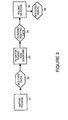
- Figure 1 is a simplified block diagram that shows a navigation system that takes into account dynamic road conditions in accordance with a preferred embodiment of the present invention.
- Figure 2 is a simplified block diagram showing information flow in a navigation system so as to take into account dynamic road conditions when presenting mapping information to a user in accordance with a preferred embodiment of the present invention.
- Figure 3 is a simplified block diagram showing information flow in a navigation system so as to take into account dynamic road conditions when routing information for a user in accordance with a preferred embodiment of the present invention.
- Figure 1 is a simplified block diagram that shows a navigation system that takes into account dynamic road conditions. Global positioning system (GPS) satellites, represented by a
GPS satellite 15 provide positioning information to aGPS receiver 12. Alternatively, another positioning system may be used to provide positioning information. A transceiver andcomputing system 11 receives positioning information fromGPS receiver 12 and uses the positioning information for mapping and routing. The mapping and routing information is displayed to a user via adisplay 14.GPS receiver 12, transceiver andcomputing system 11 anddisplay 14 can be integrated into a single hardware package. Alternatively,GPS receiver 12 can be a separate hardware system connectable to transceiver andcomputing system 11. Likewise,display 14 can be integrated with transceiver and computing system 11 (e.g., as in a laptop or handheld computing system) or may be housed separately (for example in the dashboard of a car). - A
detector 13 is used to detect dynamic road conditions in the immediate surrounding area of a vehicle in which transceiver andcomputing system 11 resides.Detector 13 is, for example, a safety warning system (SWS) compatible "smart" detector. In current SWS technology, when a "smart" detector encounters a signal known as a continuous wave on the frequency used by SWS transmitters, it stops scanning and waits for a message display code. Depending on the signal from the transmitter, the detector can display the message category or one of 60 messages. The smart detector can warn, for example, of an upcoming hazard, such as a utility crew at work, severe weather conditions or a deer-crossing area. An SWS receiver can also describe traffic delays, detours and even roadside services - SWS transmitters are often resident in emergency vehicles (represented in Figure 1 by emergency vehicle 17) such as police cars, fire trucks and ambulances. Different signals are transmitted depending upon whether the emergency vehicle is on the move with sirens and emergency lights activated or when stopped at the scene of an accident or other hazardous situation. SWS transmitters are also used to warn of a train approaching a crossing, ice-prone bridges, blind intersections, sharp curves, rock slides, poor driving conditions, school buses, school zones and transportation of oversize loads.
- A SWS transmitter can follow an initial message with a second message. For instance, the first message might indicate that a vehicle is approaching a work area or school zone, the follow-up message can include the speed limit for the location. For some categories of messages such as, Highway Construction/Maintenance, Highway Hazard Zone Advisory, Weather Related Hazards, and Travel Information/Convenience, the SWS transmitter is typically stationary. For other categories of messages, for example, Fast/Slow Moving Vehicles, the transmitter is within a moving vehicle. For more information on SWS technology, see, for example, the internet at the following web addresses: http://www.swslc.com/brochure.htm; or http://www.safetyradar.com.
- Alternatively,
detector 13 could be another type of detector, for example a radar detector that warns a user of speed traps. - Transceiver and
computing system 11 integrates the information provided bydetector 13 into the maps and routing information used by transceiver andcomputing system 11. Additionally, this information is uploaded towireless service 16 for broadcast to other vehicles in the vicinity or to any other vehicles to which the information about dynamic road conditions is pertinent. - Transceiver and computing system is in communication with
wireless service 16.Wireless service 16 accumulates information related to dynamic road conditions from vehicles equipped with navigation systems similar to transceiving andcomputing system 11 shown in Figure 1. The information related to dynamic road conditions includes, for example, information about road construction, accidents and slow traffic, etc. obtained from an SWS detector or other detector. The information can also include the traveling speed of the vehicle. In addition,wireless service 16 can obtain additional information from other sources such as state or county transportation services, weather stations, traffic reports and so on. This information is accumulated bywireless service 16 and then forwarded to vehicles to which the information applies. The information is used to dynamically update mapping information and routing information. - Figure 2 shows information flow within transceiver and
computing system 11 when presenting mapping information to a user. Amapping program 21 resides within transceiver andcomputing system 11.Mapping program 21 generatesstatic mapping data 22. For example,mapping program 21 is a standard mapping program such as Street Atlas USA or AAA Map'n'Go available from DeLorme. Alternatively,mapping program 21 is a mapping program designed specifically for use when taking into account dynamic road conditions. - A filter for
dynamic road conditions 23 receivesstatic mapping data 22 and generatesdynamic mapping data 24. For example,dynamic mapping data 24 includesstatic mapping data 22 plus the addition of information about road construction, accidents and slow traffic, etc. obtained fromdetector 13 orwireless service 16.Dynamic mapping data 24 is presented to the user viadisplay 14.Dynamic mapping data 24, for example, is displayed in the form of a recommended route, or as a map display that includes information about dynamic road conditions. - Figure 3 shows information flow within transceiver and
computing system 11 when preparing routing information for a user.Mapping program 21 generates routingdata 32 using static mapping data. In essence, routingdata 32 is a subset of all available static mapping data. Filter fordynamic road conditions 23 receives routingdata 32 and generatesdynamic routing data 34. For example,dynamic routing data 34 includesrouting data 32 adjusted for available information about dynamic road conditions such as road construction, accidents and slow traffic, etc. obtained fromdetector 13 orwireless service 16. The information about dynamic road conditions is used, for example, to adjust estimated travel speeds across roads and highways used when routingselection module 36 selects anoptimum route 36 between two locations. In addition, the information about dynamic road conditions is used by routingselection module 36 to present warnings to a user about possible obstacles, hazards and so on that are present at locations along a selected route. - Alternatively, routing data 3.2 can be directions to a location or a subset of directions to a location (e.g., a warning about an upcoming turn). In this case, dynamic routing data can be used to determine whether alternative directions are preferable or to generate warnings to be issued while the user is traveling a particular route. These warnings can be displayed to a
user using display 14 or spoken to a user using computer generated speech technology. - While Figure 2 and Figure 3 show embodiments of the present invention where filter for
dynamic road conditions 23 is used to modify information obtained frommapping program 21, as will be understood by persons of ordinary skill in the art, in alternative embodiments of the present invention, the functionality of filter fordynamic road conditions 23 can be integrated intomapping program 21. - The foregoing discussion discloses and describes merely exemplary methods and embodiments of the present invention. As will be understood by those familiar with the art, the invention may be embodied in other specific forms without departing from the spirit or essential characteristics thereof. Accordingly, the disclosure of the present invention is intended to be illustrative, but not limiting,- of the scope of the invention, which is set forth in the following claims.
Claims (10)
- A method for presenting mapping information to a user comprising the following step:(a) integrating information about dynamic road conditions into static mapping data (22) to generate dynamic mapping data (24); and,(b) displaying the dynamic mapping data (24) to a user via a display (14).
- A method as in claim 1 additionally comprising:(c) using positioning information to also display to the user a current position relative to the dynamic mapping data (24).
- A method as in claim 1 additionally comprising the following step performed before step (a):(c) obtaining the dynamic road conditions from a detector (13) that detects dynamic road conditions.
- A method as in claim 1 additionally comprising the following step performed before step (a):(c) obtaining the dynamic road conditions from a detector (13), the detector (13) being a safety warning system detector or a radar detector.
- A method as in claim 1 additionally comprising the following step performed before step (a):(c) obtaining the information about dynamic road conditions from a wireless service (16) that accumulates information about dynamic road conditions.
- A navigation system comprising:mapping data source (21) for providing static mapping data (22);dynamic road condition information procurement means (13) for procuring information about dynamic road conditions; and,integration means (23) for integrating the information about dynamic road conditions into the static mapping data (22).
- A navigation system as in claim 6 additionally comprising:a transmitter (11) for forwarding the information about dynamic road conditions to a wireless service (16) that accumulates information about dynamic road conditions.
- A navigation system as in claim 6 wherein the dynamic road condition information procurement means (13) comprises a detector (13) that detects dynamic road conditions.
- A navigation system as in claim 6 wherein the dynamic road condition information procurement means (13) comprises a detector (13) that detects dynamic road conditions, the detector (13) being a safety warning system detector or a radar detector.
- A navigation system as in claim 6 wherein the dynamic road condition information procurement means (13) is a receiver (11) that receives the information about dynamic road conditions from a wireless service (16) that accumulates information about dynamic road conditions.
Applications Claiming Priority (2)
| Application Number | Priority Date | Filing Date | Title |
|---|---|---|---|
| US834341 | 2001-04-13 | ||
| US09/834,341 US6662106B2 (en) | 2001-04-13 | 2001-04-13 | Navigation system that takes into account dynamic road conditions |
Related Child Applications (1)
| Application Number | Title | Priority Date | Filing Date |
|---|---|---|---|
| EP10012864.4 Division-Into | 2010-10-01 |
Publications (3)
| Publication Number | Publication Date |
|---|---|
| EP1249810A2 true EP1249810A2 (en) | 2002-10-16 |
| EP1249810A3 EP1249810A3 (en) | 2004-05-26 |
| EP1249810B1 EP1249810B1 (en) | 2013-11-06 |
Family
ID=25266703
Family Applications (1)
| Application Number | Title | Priority Date | Filing Date |
|---|---|---|---|
| EP02252481.3A Expired - Fee Related EP1249810B1 (en) | 2001-04-13 | 2002-04-05 | Navigation system that takes into account dynamic road conditions |
Country Status (3)
| Country | Link |
|---|---|
| US (1) | US6662106B2 (en) |
| EP (1) | EP1249810B1 (en) |
| JP (1) | JP2002365072A (en) |
Cited By (5)
| Publication number | Priority date | Publication date | Assignee | Title |
|---|---|---|---|---|
| GB2447731A (en) * | 2007-03-20 | 2008-09-24 | Ford Global Tech Llc | Wireless Vehicle Communication |
| EP2101150A2 (en) * | 2008-03-10 | 2009-09-16 | Deutsche Telekom AG | Method for speaking dynamic navigation with static traffic data and dynamic selection |
| EP2420964A4 (en) * | 2009-05-18 | 2015-05-13 | Thinkware Systems Corp | Method and apparatus for providing dynamic advertisements |
| CN105243835A (en) * | 2015-09-25 | 2016-01-13 | 成都曜诚通科技有限公司 | High-efficiency integrated traffic informatization system |
| CN108369101A (en) * | 2015-12-17 | 2018-08-03 | 米其林集团总公司 | The method for indicating the data about condition of road surface for map |
Families Citing this family (36)
| Publication number | Priority date | Publication date | Assignee | Title |
|---|---|---|---|---|
| US8352400B2 (en) | 1991-12-23 | 2013-01-08 | Hoffberg Steven M | Adaptive pattern recognition based controller apparatus and method and human-factored interface therefore |
| US10361802B1 (en) | 1999-02-01 | 2019-07-23 | Blanding Hovenweep, Llc | Adaptive pattern recognition based control system and method |
| US7966078B2 (en) | 1999-02-01 | 2011-06-21 | Steven Hoffberg | Network media appliance system and method |
| JP3866532B2 (en) * | 2001-06-13 | 2007-01-10 | 富士通株式会社 | Mobile object safe operation support apparatus and computer program |
| US7027915B2 (en) * | 2002-10-09 | 2006-04-11 | Craine Dean A | Personal traffic congestion avoidance system |
| US6845317B2 (en) * | 2002-11-04 | 2005-01-18 | Dean A. Craine | Navigational-based speed limit recording and warning system |
| US20050096840A1 (en) * | 2003-11-03 | 2005-05-05 | Simske Steven J. | Navigation routing system and method |
| US7949726B2 (en) * | 2004-03-12 | 2011-05-24 | Ocean And Coastal Environmental Sensing, Inc. | System and method for delivering information on demand |
| US7298248B2 (en) * | 2004-07-19 | 2007-11-20 | K40 Electronics | Communication system for vehicles |
| US20060242108A1 (en) * | 2005-04-25 | 2006-10-26 | The Boeing Company | Advanced ground transportation management |
| US7761226B1 (en) | 2005-07-27 | 2010-07-20 | The United States Of America As Represented By The Secretary Of The Navy | Interactive pedestrian routing system |
| US11214144B2 (en) | 2005-11-17 | 2022-01-04 | Invently Automotive Inc. | Electric vehicle power management system |
| US11207980B2 (en) | 2005-11-17 | 2021-12-28 | Invently Automotive Inc. | Vehicle power management system responsive to traffic conditions |
| US11351863B2 (en) | 2005-11-17 | 2022-06-07 | Invently Automotive Inc. | Vehicle power management system |
| US11180025B2 (en) | 2005-11-17 | 2021-11-23 | Invently Automotive Inc. | Electric vehicle power management system |
| US11345236B2 (en) | 2005-11-17 | 2022-05-31 | Invently Automotive Inc. | Electric vehicle power management system |
| US11186175B2 (en) | 2005-11-17 | 2021-11-30 | Invently Automotive Inc. | Vehicle power management system |
| US20070208506A1 (en) * | 2006-03-03 | 2007-09-06 | Ford Motor Company | Travel system for a vehicle |
| US8063792B2 (en) * | 2006-09-18 | 2011-11-22 | Neptune Technology Group, Inc. | Field service and meter reading devices with GPS functionality |
| US7928891B2 (en) * | 2007-09-18 | 2011-04-19 | Edward Zheng | GPS with radar detector |
| TWI397675B (en) * | 2008-11-01 | 2013-06-01 | Ming Han Chang | Scheduling system and itinerary method |
| US8373588B2 (en) * | 2009-02-20 | 2013-02-12 | Escort Inc. | Wireless connectivity in a radar detector |
| US20100250111A1 (en) * | 2009-03-26 | 2010-09-30 | B&C Electronic Engineering, Inc. | Emergency and traffic alert system |
| US8612131B2 (en) * | 2009-03-26 | 2013-12-17 | B&C Electronic Engineering, Inc. | Emergency and traffic alert system |
| CN101763729B (en) * | 2009-12-29 | 2012-12-12 | 北京世纪高通科技有限公司 | Method and apparatus for extracting characteristic value of road condition data |
| US9026360B2 (en) * | 2013-06-05 | 2015-05-05 | General Electric Company | Systems and methods for providing constant warning time at crossings |
| EP2940672B1 (en) * | 2014-04-29 | 2018-03-07 | Fujitsu Limited | Vehicular safety system |
| US9869564B2 (en) | 2014-09-30 | 2018-01-16 | Apple Inc. | Method and apparatus for providing dynamic warnings for navigations |
| US11100797B2 (en) | 2015-06-05 | 2021-08-24 | Apple Inc. | Traffic notifications during navigation |
| US10460534B1 (en) * | 2015-10-26 | 2019-10-29 | Allstate Insurance Company | Vehicle-to-vehicle accident detection |
| CN105976631A (en) * | 2015-11-06 | 2016-09-28 | 乐卡汽车智能科技(北京)有限公司 | Vehicle data processing method and vehicle terminal |
| CN105976609A (en) * | 2015-11-06 | 2016-09-28 | 乐卡汽车智能科技(北京)有限公司 | Vehicle data processing system and method |
| CN105989712A (en) * | 2015-11-06 | 2016-10-05 | 乐卡汽车智能科技(北京)有限公司 | Vehicle data processing method and vehicle terminal |
| US10408937B2 (en) | 2016-09-20 | 2019-09-10 | Ford Global Technologies, Llc | Metal bridge detection systems and methods |
| US11186295B2 (en) | 2017-12-22 | 2021-11-30 | Veripat, LLC | Vehicle with escape feature using synthesized vehicle view |
| CN112595331A (en) * | 2020-12-14 | 2021-04-02 | 上海市政工程设计研究总院(集团)有限公司 | Motor vehicle dynamic positioning and navigation system with computer video and map method integrated |
Citations (6)
| Publication number | Priority date | Publication date | Assignee | Title |
|---|---|---|---|---|
| GB2250619A (en) * | 1990-10-31 | 1992-06-10 | Norm Pacific Automat Corp | Traffic information inter-vehicle transference and a navigation system |
| US5850190A (en) * | 1997-03-06 | 1998-12-15 | Sony Corporation | Traffic information pager |
| DE19746784A1 (en) * | 1997-10-23 | 1999-04-29 | Christian Schaeffer | Signaling means for warning road users of emergency vehicles |
| EP0935227A2 (en) * | 1998-02-06 | 1999-08-11 | Matsushita Electric Industrial Co., Ltd. | Map information providing method and terminal device used therein |
| EP0947850A2 (en) * | 1998-03-31 | 1999-10-06 | Sony Corporation | Method and apparatus for acquiring map and providing area information for navigating a car |
| US6204798B1 (en) * | 1999-04-14 | 2001-03-20 | Fleming, Iii Hoyt A. | Method and apparatus for alerting an operator of a motor vehicle to an incoming radar signal |
Family Cites Families (5)
| Publication number | Priority date | Publication date | Assignee | Title |
|---|---|---|---|---|
| DE19650844C2 (en) * | 1996-11-27 | 2003-09-25 | Mannesmann Ag | Procedure for determining route data |
| US6252544B1 (en) * | 1998-01-27 | 2001-06-26 | Steven M. Hoffberg | Mobile communication device |
| DE60010993T2 (en) * | 1999-08-17 | 2005-06-09 | Toyota Jidosha K.K., Toyota | Route guidance device |
| US6377210B1 (en) * | 2000-02-25 | 2002-04-23 | Grey Island Systems, Inc. | Automatic mobile object locator apparatus and method |
| US6484092B2 (en) * | 2001-03-28 | 2002-11-19 | Intel Corporation | Method and system for dynamic and interactive route finding |
-
2001
- 2001-04-13 US US09/834,341 patent/US6662106B2/en not_active Expired - Lifetime
-
2002
- 2002-03-20 JP JP2002077523A patent/JP2002365072A/en active Pending
- 2002-04-05 EP EP02252481.3A patent/EP1249810B1/en not_active Expired - Fee Related
Patent Citations (6)
| Publication number | Priority date | Publication date | Assignee | Title |
|---|---|---|---|---|
| GB2250619A (en) * | 1990-10-31 | 1992-06-10 | Norm Pacific Automat Corp | Traffic information inter-vehicle transference and a navigation system |
| US5850190A (en) * | 1997-03-06 | 1998-12-15 | Sony Corporation | Traffic information pager |
| DE19746784A1 (en) * | 1997-10-23 | 1999-04-29 | Christian Schaeffer | Signaling means for warning road users of emergency vehicles |
| EP0935227A2 (en) * | 1998-02-06 | 1999-08-11 | Matsushita Electric Industrial Co., Ltd. | Map information providing method and terminal device used therein |
| EP0947850A2 (en) * | 1998-03-31 | 1999-10-06 | Sony Corporation | Method and apparatus for acquiring map and providing area information for navigating a car |
| US6204798B1 (en) * | 1999-04-14 | 2001-03-20 | Fleming, Iii Hoyt A. | Method and apparatus for alerting an operator of a motor vehicle to an incoming radar signal |
Cited By (6)
| Publication number | Priority date | Publication date | Assignee | Title |
|---|---|---|---|---|
| GB2447731A (en) * | 2007-03-20 | 2008-09-24 | Ford Global Tech Llc | Wireless Vehicle Communication |
| EP2101150A2 (en) * | 2008-03-10 | 2009-09-16 | Deutsche Telekom AG | Method for speaking dynamic navigation with static traffic data and dynamic selection |
| EP2101150A3 (en) * | 2008-03-10 | 2012-01-04 | Deutsche Telekom AG | Method for speaking dynamic navigation with static traffic data and dynamic selection |
| EP2420964A4 (en) * | 2009-05-18 | 2015-05-13 | Thinkware Systems Corp | Method and apparatus for providing dynamic advertisements |
| CN105243835A (en) * | 2015-09-25 | 2016-01-13 | 成都曜诚通科技有限公司 | High-efficiency integrated traffic informatization system |
| CN108369101A (en) * | 2015-12-17 | 2018-08-03 | 米其林集团总公司 | The method for indicating the data about condition of road surface for map |
Also Published As
| Publication number | Publication date |
|---|---|
| JP2002365072A (en) | 2002-12-18 |
| EP1249810B1 (en) | 2013-11-06 |
| US20020152026A1 (en) | 2002-10-17 |
| US6662106B2 (en) | 2003-12-09 |
| EP1249810A3 (en) | 2004-05-26 |
Similar Documents
| Publication | Publication Date | Title |
|---|---|---|
| US6662106B2 (en) | Navigation system that takes into account dynamic road conditions | |
| US6411896B1 (en) | Method and system for providing warnings to drivers of vehicles about slow-moving, fast-moving, or stationary objects located around the vehicles | |
| US7925423B2 (en) | System and method for traffic condition detection | |
| US6583734B2 (en) | Enhanced vehicle hazard warning and safety features integrated with an onboard navigation system | |
| US7432829B2 (en) | Apparatus and method for providing travel information | |
| US7893849B2 (en) | Apparatus and method for providing travel information | |
| US5844505A (en) | Automobile navigation system | |
| US6895332B2 (en) | GPS-based vehicle warning and location system and method | |
| US6442473B1 (en) | Method and apparatus for presenting traffic information in a vehicle | |
| US8108135B2 (en) | Traffic congestion degree determination device, traffic congestion degree notification device, and program | |
| US20030128135A1 (en) | Apparatus and method for providing for the remote control of traffic control devices along a travel route | |
| US6636799B2 (en) | Method and apparatus for modification of vehicular navigation information | |
| US20080303660A1 (en) | Emergency event detection and alert system and method | |
| US7010397B1 (en) | Utilization by a vehicle of wireless data from intelligent street signs | |
| JP2008184129A (en) | Vehicle compartment noise control system | |
| US20150134240A1 (en) | Imitation sound generation system and map database | |
| JP2002195840A (en) | Navigation system for vehicle | |
| JPH1096643A (en) | Navigator | |
| Regan | A Sign of the Future I: Intelligent Transport Systems | |
| JP2002269681A (en) | Radio regulation previous notice informing system and method therefor | |
| JPH11144193A (en) | On-vehicle navigation device | |
| JP2009140190A (en) | Driving-supporting device, driving-supporting method, driving-supporting program, and storage medium | |
| KR101042034B1 (en) | Vehicle-mounted type information guide apparatus for providing a driver or passengers of any other vehicle with vehicle driving-related information, and system for providing vehicle driving-related information | |
| Sweeney | An overview of intelligent vehicle highway systems (IVHS) | |
| Bell | The future for in‐vehicle information systems: The technology and its impacts |
Legal Events
| Date | Code | Title | Description |
|---|---|---|---|
| PUAI | Public reference made under article 153(3) epc to a published international application that has entered the european phase |
Free format text: ORIGINAL CODE: 0009012 |
|
| AK | Designated contracting states |
Kind code of ref document: A2 Designated state(s): AT BE CH CY DE DK ES FI FR GB GR IE IT LI LU MC NL PT SE TR |
|
| AX | Request for extension of the european patent |
Free format text: AL;LT;LV;MK;RO;SI |
|
| PUAL | Search report despatched |
Free format text: ORIGINAL CODE: 0009013 |
|
| AK | Designated contracting states |
Kind code of ref document: A3 Designated state(s): AT BE CH CY DE DK ES FI FR GB GR IE IT LI LU MC NL PT SE TR |
|
| AX | Request for extension of the european patent |
Extension state: AL LT LV MK RO SI |
|
| 17P | Request for examination filed |
Effective date: 20041105 |
|
| AKX | Designation fees paid |
Designated state(s): DE FR GB |
|
| 17Q | First examination report despatched |
Effective date: 20070626 |
|
| RAP1 | Party data changed (applicant data changed or rights of an application transferred) |
Owner name: HEWLETT-PACKARD DEVELOPMENT COMPANY, L.P. |
|
| REG | Reference to a national code |
Ref country code: DE Ref legal event code: R079 Ref document number: 60245716 Country of ref document: DE Free format text: PREVIOUS MAIN CLASS: G08G0001096900 Ipc: G01C0021260000 |
|
| RIC1 | Information provided on ipc code assigned before grant |
Ipc: G08G 1/0967 20060101ALI20130314BHEP Ipc: G01C 21/26 20060101AFI20130314BHEP |
|
| GRAP | Despatch of communication of intention to grant a patent |
Free format text: ORIGINAL CODE: EPIDOSNIGR1 |
|
| INTG | Intention to grant announced |
Effective date: 20130523 |
|
| GRAS | Grant fee paid |
Free format text: ORIGINAL CODE: EPIDOSNIGR3 |
|
| GRAA | (expected) grant |
Free format text: ORIGINAL CODE: 0009210 |
|
| AK | Designated contracting states |
Kind code of ref document: B1 Designated state(s): DE FR GB |
|
| REG | Reference to a national code |
Ref country code: GB Ref legal event code: FG4D |
|
| REG | Reference to a national code |
Ref country code: DE Ref legal event code: R096 Ref document number: 60245716 Country of ref document: DE Effective date: 20140102 |
|
| REG | Reference to a national code |
Ref country code: DE Ref legal event code: R097 Ref document number: 60245716 Country of ref document: DE |
|
| PLBE | No opposition filed within time limit |
Free format text: ORIGINAL CODE: 0009261 |
|
| STAA | Information on the status of an ep patent application or granted ep patent |
Free format text: STATUS: NO OPPOSITION FILED WITHIN TIME LIMIT |
|
| 26N | No opposition filed |
Effective date: 20140807 |
|
| REG | Reference to a national code |
Ref country code: DE Ref legal event code: R097 Ref document number: 60245716 Country of ref document: DE Effective date: 20140807 |
|
| REG | Reference to a national code |
Ref country code: FR Ref legal event code: PLFP Year of fee payment: 15 |
|
| REG | Reference to a national code |
Ref country code: FR Ref legal event code: PLFP Year of fee payment: 16 |
|
| REG | Reference to a national code |
Ref country code: FR Ref legal event code: PLFP Year of fee payment: 17 |
|
| PGFP | Annual fee paid to national office [announced via postgrant information from national office to epo] |
Ref country code: GB Payment date: 20180321 Year of fee payment: 17 |
|
| PGFP | Annual fee paid to national office [announced via postgrant information from national office to epo] |
Ref country code: FR Payment date: 20180322 Year of fee payment: 17 |
|
| PGFP | Annual fee paid to national office [announced via postgrant information from national office to epo] |
Ref country code: DE Payment date: 20180320 Year of fee payment: 17 |
|
| REG | Reference to a national code |
Ref country code: DE Ref legal event code: R119 Ref document number: 60245716 Country of ref document: DE |
|
| GBPC | Gb: european patent ceased through non-payment of renewal fee |
Effective date: 20190405 |
|
| PG25 | Lapsed in a contracting state [announced via postgrant information from national office to epo] |
Ref country code: GB Free format text: LAPSE BECAUSE OF NON-PAYMENT OF DUE FEES Effective date: 20190405 Ref country code: DE Free format text: LAPSE BECAUSE OF NON-PAYMENT OF DUE FEES Effective date: 20191101 |
|
| PG25 | Lapsed in a contracting state [announced via postgrant information from national office to epo] |
Ref country code: FR Free format text: LAPSE BECAUSE OF NON-PAYMENT OF DUE FEES Effective date: 20190430 |