EP0933616A1 - System and method for dynamic guidance of vehicles - Google Patents
System and method for dynamic guidance of vehicles Download PDFInfo
- Publication number
- EP0933616A1 EP0933616A1 EP99400244A EP99400244A EP0933616A1 EP 0933616 A1 EP0933616 A1 EP 0933616A1 EP 99400244 A EP99400244 A EP 99400244A EP 99400244 A EP99400244 A EP 99400244A EP 0933616 A1 EP0933616 A1 EP 0933616A1
- Authority
- EP
- European Patent Office
- Prior art keywords
- route
- module
- vehicle
- database
- server
- Prior art date
- Legal status (The legal status is an assumption and is not a legal conclusion. Google has not performed a legal analysis and makes no representation as to the accuracy of the status listed.)
- Withdrawn
Links
- 238000000034 method Methods 0.000 title claims description 27
- 238000012545 processing Methods 0.000 claims abstract description 34
- 238000004891 communication Methods 0.000 claims description 56
- 230000006854 communication Effects 0.000 claims description 56
- 238000004364 calculation method Methods 0.000 claims description 27
- 230000005540 biological transmission Effects 0.000 claims description 20
- 238000006073 displacement reaction Methods 0.000 claims description 11
- 239000000284 extract Substances 0.000 claims description 10
- 230000002457 bidirectional effect Effects 0.000 claims description 9
- 230000006870 function Effects 0.000 claims description 7
- 230000007423 decrease Effects 0.000 claims description 3
- 238000009877 rendering Methods 0.000 claims description 3
- 238000013459 approach Methods 0.000 claims description 2
- 238000009792 diffusion process Methods 0.000 claims description 2
- 239000000203 mixture Substances 0.000 claims 3
- 238000012544 monitoring process Methods 0.000 claims 3
- 230000000737 periodic effect Effects 0.000 claims 2
- 238000013507 mapping Methods 0.000 description 14
- 238000010586 diagram Methods 0.000 description 7
- 230000008901 benefit Effects 0.000 description 5
- 230000004807 localization Effects 0.000 description 4
- 238000010295 mobile communication Methods 0.000 description 4
- 230000001413 cellular effect Effects 0.000 description 3
- 238000011017 operating method Methods 0.000 description 3
- 230000008569 process Effects 0.000 description 3
- 239000013598 vector Substances 0.000 description 2
- 238000012795 verification Methods 0.000 description 2
- 230000007175 bidirectional communication Effects 0.000 description 1
- 238000012790 confirmation Methods 0.000 description 1
- 230000002950 deficient Effects 0.000 description 1
- 230000000593 degrading effect Effects 0.000 description 1
- 238000001514 detection method Methods 0.000 description 1
- 229940082150 encore Drugs 0.000 description 1
- 238000005516 engineering process Methods 0.000 description 1
- VKYKSIONXSXAKP-UHFFFAOYSA-N hexamethylenetetramine Chemical compound C1N(C2)CN3CN1CN2C3 VKYKSIONXSXAKP-UHFFFAOYSA-N 0.000 description 1
- 238000012986 modification Methods 0.000 description 1
- 230000004048 modification Effects 0.000 description 1
- 230000009467 reduction Effects 0.000 description 1
- 230000004044 response Effects 0.000 description 1
- 230000000007 visual effect Effects 0.000 description 1
Images

Classifications
-
- G—PHYSICS
- G01—MEASURING; TESTING
- G01C—MEASURING DISTANCES, LEVELS OR BEARINGS; SURVEYING; NAVIGATION; GYROSCOPIC INSTRUMENTS; PHOTOGRAMMETRY OR VIDEOGRAMMETRY
- G01C21/00—Navigation; Navigational instruments not provided for in groups G01C1/00 - G01C19/00
- G01C21/26—Navigation; Navigational instruments not provided for in groups G01C1/00 - G01C19/00 specially adapted for navigation in a road network
- G01C21/34—Route searching; Route guidance
- G01C21/36—Input/output arrangements for on-board computers
-
- G—PHYSICS
- G08—SIGNALLING
- G08G—TRAFFIC CONTROL SYSTEMS
- G08G1/00—Traffic control systems for road vehicles
- G08G1/09—Arrangements for giving variable traffic instructions
- G08G1/0962—Arrangements for giving variable traffic instructions having an indicator mounted inside the vehicle, e.g. giving voice messages
- G08G1/0968—Systems involving transmission of navigation instructions to the vehicle
- G08G1/096805—Systems involving transmission of navigation instructions to the vehicle where the transmitted instructions are used to compute a route
- G08G1/096811—Systems involving transmission of navigation instructions to the vehicle where the transmitted instructions are used to compute a route where the route is computed offboard
-
- G—PHYSICS
- G08—SIGNALLING
- G08G—TRAFFIC CONTROL SYSTEMS
- G08G1/00—Traffic control systems for road vehicles
- G08G1/09—Arrangements for giving variable traffic instructions
- G08G1/0962—Arrangements for giving variable traffic instructions having an indicator mounted inside the vehicle, e.g. giving voice messages
- G08G1/0968—Systems involving transmission of navigation instructions to the vehicle
- G08G1/096833—Systems involving transmission of navigation instructions to the vehicle where different aspects are considered when computing the route
- G08G1/096844—Systems involving transmission of navigation instructions to the vehicle where different aspects are considered when computing the route where the complete route is dynamically recomputed based on new data
-
- G—PHYSICS
- G08—SIGNALLING
- G08G—TRAFFIC CONTROL SYSTEMS
- G08G1/00—Traffic control systems for road vehicles
- G08G1/09—Arrangements for giving variable traffic instructions
- G08G1/0962—Arrangements for giving variable traffic instructions having an indicator mounted inside the vehicle, e.g. giving voice messages
- G08G1/0968—Systems involving transmission of navigation instructions to the vehicle
- G08G1/096855—Systems involving transmission of navigation instructions to the vehicle where the output is provided in a suitable form to the driver
- G08G1/096861—Systems involving transmission of navigation instructions to the vehicle where the output is provided in a suitable form to the driver where the immediate route instructions are output to the driver, e.g. arrow signs for next turn
-
- G—PHYSICS
- G08—SIGNALLING
- G08G—TRAFFIC CONTROL SYSTEMS
- G08G1/00—Traffic control systems for road vehicles
- G08G1/09—Arrangements for giving variable traffic instructions
- G08G1/0962—Arrangements for giving variable traffic instructions having an indicator mounted inside the vehicle, e.g. giving voice messages
- G08G1/0968—Systems involving transmission of navigation instructions to the vehicle
- G08G1/096855—Systems involving transmission of navigation instructions to the vehicle where the output is provided in a suitable form to the driver
- G08G1/096872—Systems involving transmission of navigation instructions to the vehicle where the output is provided in a suitable form to the driver where instructions are given per voice
Definitions
- the present invention relates to a guidance system vehicle dynamics, as well as the guidance achievable thanks to this system, exploiting the cartographic data and information on the road traffic, received from a remote server.
- the map data sent by the server to the vehicle are encoded using parametric road models.
- navigation systems offering the possibility of dynamic guidance must consider users occasional of this guidance service, which does not not want to invest in a system dedicated to guidance.
- Such users are looking for a low cost navigation and traffic information, possibly re-using an embedded system existing in the vehicle, such as a telephony, an Internet terminal, a module emergency call or fleet management for example.
- GSM radiotelephone for example, like the SOCRATES system
- R.D.S.-T.M.C. Radio Data System - Traffic Message Channel
- a solution is provided by the system described in the German patent application DE-19531824 by V.D.O., which transmits through the G.S.M. network the route calculated by a server, as well as guidance instructions under the form of crossing modes of crossroads.
- a disadvantage of this system is the poor quality insufficiently clear guidance instructions. Of plus, determining the vehicle's position on the road network, as well as the detection of an exit of the calculated route are impossible, since none information on the description of the roads connecting crossroads is not transmitted to the vehicle.
- the aim of the invention is to overcome these drawbacks, by downloading the maps, or extracts of maps, based on models parametric route.
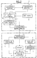
- the dynamic guidance system of a vehicle is composed of a device 1 on board the vehicle and a remote server 2, outside the vehicle.
- the detailed cartographic databases 10 of a hand and regarding road traffic 12 on the other hand can be outside remote server 2 and accessible by a telecommunications network, by example through the Internet.
- cartographic database 11 simplified and 12 information database road can be confused.
- the simplified cartography of the road network is obtained by modeling roads, so that it does not occupy a large memory.
- the on-board device there is no need to have maps covering a large area area; indeed, depending on the position of the vehicle and its destination given by the user, only the useful mapping can be downloaded from the server distant towards the vehicle, this mapping being able even be reduced to a route.
- the on-board device 1 can be used to several other services than those of guidance, like fleet management, emergency call or others telematics applications, which reduces its cost.
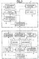
- Figure 2 is a block diagram of a first example of the dynamic guidance system according to the invention, in which the route calculation is performed by the remote server.
- the first mobile communication module 3 is bidirectional, allowing the reciprocal exchange of words and data between the embedded system and the server distant.
- Memory 5 stores the data received from remote server 2, i.e. the route optimal calculated with useful road models for rebuild routes from the database simplified cartographic. For this, she can understand a specific message storage area voice sent by the server.
- the first electronic processing unit 8 provides vehicle position tracking on the route, thanks to a module 16.
- the second module 9 of communication is bidirectional.
- the second electronic processing unit 13 comprises on the one hand, a module 14 for query interpretation of the user, whether in voice form or no, sent by the first communication module 3 on-board device 1. It can consist of means of speech recognition, possibly completed by an operator in case the speech recognition algorithms would fail.
- the operating method of this embodiment particular includes the following phases.
- a first phase of guidance request by the vehicle user, performed by the device on-board 1, includes a step of establishing a communication between its communication module and that of the remote server.
- the user then composes a request, comprising mainly the destination to which the user wants to be guided, as well as several waypoints specified if necessary.
- This request established using the command module 6, is present in the form of electrical signals corresponding to the keys on a keyboard or preferably words converted into signals electric by a microphone.
- the corresponding electrical signals are emitted from a communication module to each other, using a speech or data exchange channel. Simultaneously, the location module 4 sends also the current position of the vehicle.
- a second phase of calculating the route requested by the user enters the current vehicle position and its given destination is performed by the server distant and consists first of all of an interpretation of the user's request by module 14, which translated into commands understandable by module 15 route calculation. In the most case ergonomic where the request is composed of words, it is interpreted by means of recognition of the speech included in module 14. An operator can manually translate the voice command if these the latter are defective.
- the module 15 for calculating an optimal route receives this request mainly composed of the destination to which the user wishes to be guided, possibly with waypoints, and the current location of the vehicle.
- This module 15 queries the cartographic databases 11 and traffic information 12 to deduce a route optimal in time and distance.
- This route consists of coordinates geographic points of the road network, such as crossroads, and sections described using models parametric route. At each point and at each section are associated with text information or corresponding to the directions to follow, the distance from the points of the network to which must be voice information, and the length of these voice messages.
- the communication module 9 transmits these information in module 3 of the on-board device, voice channel and data channel digital.
- a third phase then consists in memorizing, by on-board device 1, all this information transmitted by the remote server 2, in the memory 5.
- a position tracking module 16 belonging to the first processing unit 8 reconstructs the routes the route from parametric models transmitted by the remote server and stored in said memory. This can also be done by the transmission by the server of a simple identifier to point to a list of previously known models of the on-board system, stored in the memory provided for this purpose. The road is determined by applying the model to others data defining the route, such as the equation of the route, its parameters, the conditions ends, etc ....
- position tracking is then capable identify the axis on which the vehicle is traveling and its position on this axis with a view to guiding it towards the designated destination.
- the position tracking module 16 performs the comparison between vehicle journey and route calculated stored in memory 5. As soon as the distance between location and a current decision point is less than message presentation distances also stored in memory 5, the module order position tracking in module 7 of presentation information display of text indications corresponding and the transmission of the voice message.
- the user can also detect an exit from this route and warn the user by visual and audible indications. Indeed, it checks that the vehicle follows the recommended route using parametric models of the road sections. Otherwise, the user can join the recommended route thanks in particular to an indication of direction towards a point of this route, in the form of display of a graphic arrow for example. In another version, the user can send a new guidance request to the remote server 2 which will then recalculate a new route.
- Figure 3 is a block diagram of a second exemplary embodiment of the system according to the invention, in which the route calculation is carried out by the remote server, with possibility for the device embedded to calculate a route itself in a strip located around the main route.
- an extract from the simplified cartography, stored in remote server 2 is transmitted to device on board the vehicle, this extract corresponding to a displacement band around the calculated route, which covers possible user trips outside this route.
- this mapped strip memorized in the on-board device 1, the latter can calculate a route bringing the vehicle back to the route initial and guide it through the guidance indications contained in this map extract.
- the first module 3 of on-board device communication ensures two-way mobile communication with the remote server 2
- module 4 provides localization of the vehicle in real time
- module 6 allows entry user requests that are interpreted by a module 17 of the electronic processing unit 8, on the on-board device 1.
- This same processing unit further includes a vehicle position tracking module 16 on the route, as well as an on-board calculation module 18 a route from the map extract simplified sent by the server and covering a band of displacement around the route calculated by the server.
- a module 7 provides the presentation of guidance information to the user, by summary voice and display for text data or graphics.
- the memory 5 includes a first zone 19 for memorizing data concerning the route, received from server 2, and a second area 20 to store useful route models for reconstruct the routes of the route from the simplified cartography 11, and an extract from this same simplified cartography 11 corresponding to the band of movement of the vehicle around the calculated route.
- the remote server 2 of the vehicle includes the same elements as in the first embodiment described in connection with figure 2, with a module 9 providing two-way fixed communication.
- the operating method of this second mode of particular realization includes a first phase of guidance request, by the vehicle user, to a destination it indicates with possibly crossing points, from its current location.
- This first phase is identical to the first phase of the embodiment guidance system.
- the method comprises a second phase of calculating a optimal route from the database simplified cartographic map 11 and database 12 traffic information, carried out in the same way by the route calculation module 15 only during the first embodiment of the system.
- this calculation module 15 also determines a travel strip around the route previously calculated, which is an extract from the simplified cartography 11.
- This displacement band can be defined according to geometric criteria, like the bandwidth, which can decrease when you is approaching the destination point, for example. She can also be set according to the length of the route, its width being all the more narrow the route is long, to limit the amount of data to be transmitted and thus achieve a compromise between quality of service and cost of service offered to the user.
- a fourth dynamic guidance phase carried out by the on-board device 1, firstly includes the setting in memory of the route calculated in the first area 19 and the displacement tape in the second zone 20.
- the guidance consists then in a reconstruction of the roads of the route by the position tracking module 16, identification of the vehicle traffic route and the issuance of guidance indications to the destination if the processing unit 8 verifies that the vehicle is on the calculated route.
- This verification is the result of a comparison between the route actually followed by the vehicle and the route calculated using parametric models of roads.
- module 18 recalculates a route for guide him to the initial route then his destination.
- module 7 for presenting information can help him get back there by displaying an arrow indicating the direction of a point on the strip or the destination.
- the user himself can send a new guidance request to the server remote 2, to calculate a new route with a new displacement band.
- the on-board device helps the driver to return to the network of included routes, by display of an arrow indicating a point of the strip travel or destination.
- the dynamic guidance system according to the invention can also be realized according to a third mode particular, in which most of the guidance is performed by the on-board device, while the role from the remote server is to transmit the basics of updated map data.
- the duration of transmission is relatively short thanks to the models parametric routes.
- FIG. 4 is a block diagram of this third embodiment of the invention.
- the device on-board includes a communication module 3, which is unidirectional authorizing communication from the server towards the vehicle in a first case, represented by a simple dotted arrow. It can be based on data dissemination methods, such as the protocol SWIFT for modulation radio broadcasts frequency, or the D.A.B. for example.
- module 3 is no longer just a receiver but is based on a mode of exchange of data expected in some cellular networks of telephony, like the G.S.M. network, authorizing a two-way point-to-point communication between the embedded device and server, shown symbolically by a double arrow in solid line.
- the on-board device includes a module 6 for entering user requests, a presentation module 7 guidance information in the vehicle, a module 4 real-time vehicle location, one unit electronic processing unit 8 comprising a module 17 for interpreting requests received from the input, a module 18 for calculating an optimal route from the commands sent by module 17 and from information stored in memory 5, and a module 16 for tracking the position of the vehicle from its location, route models and the simplified cartography memorized.
- the memory 5 is composed of a first area 19 where various information such as traffic is stored road, a second zone 20 where the simplified mapping from the database 11 of server 2, and a third zone 21 where are stored the road models which can be downloaded at the same time as the cartography simplified.
- the remote server 2 is composed in a first case a transmitter, SWIFT, DAB, etc., broadcasting data, and in a second case of a transceiver compatible with exchange protocols cellular radio network data.
- the operating method of this third mode of particular embodiment of a guidance system according to the invention is based on the transmission of the base of simplified map data 11 to the device on-board 1 in the vehicle, which will perform the calculation optimal route itself as well as guidance vehicle dynamics.
- the first part of the method is to periodically transmit the simplified mapping from remote server 2 to on-board device 1, which stores it in the second area 20 of memory 5.
- This mapping is reset updated periodically by the server including module 9 of communication achieves rapid transmission, thanks to the fact that this simplified mapping 11 uses parametric road models.
- So memory 5 can store a large geographic area, such as the territory of a country, which can be defined as a disc of determined radius having for center the module 9 from the server 2.
- the first unidirectional communication module 3 of the vehicle regularly scans the data sent by the remote server and compare the version of the modeled mapping issued, defined by its number or its modification date, with the saved version in the second memory 20. If the memorized version is earlier than the version issued, it is replaced by the latter in memory.
- mapping simplified road network in geographic areas, like the departments of a country for example.
- the version numbers are managed for each zone cutting module updated and receiving module 3 of the vehicle performs the comparison between the version memorized and the version sent for each one.
- One advantage of this possibility is the emission more frequent from neighboring geographic areas of the transmitter.
- module 9 can contact the vehicle to warn him that a new version of the database is available and module 3 of embedded device 1 can reach the server to request a download of the database cartographic.
- the second part of the operating process of this third embodiment is the realization of the dynamic vehicle guidance according to a procedure classic.
- the communication module 3 of the on-board device 1 scans traffic information sent by server 2 and stores them in a zone temporary memory 21.
- the route calculation module 18 receives the information stored in the memory 5, concerning road traffic and cartography, and determines the optimal route from the position of the vehicle located thanks to module 4 of localization, possibly refined by module 16 position tracking.
- the route calculation being made the guidance takes place and the vehicle position tracking module 16 restores roads around its position. For that, it searches, in a list stored in the third memory area 21, the model corresponding to the model identifier transmitted for each route by the server 2.
- the guidance consists, after this route reconstruction of the route and the identification of the traffic route of the vehicle, to issue guidance indications if the processing unit 8 has verified that the vehicle runs well on the calculated route. This verification is identical to that already described.
- the third embodiment can be based, depending on another variant, on the transmission of the base of simplified cartographic data, broken down into au minus two levels, a first level called “base of global data "which basically includes major traffic axes in a geographical area scope, and a second level called “database locale "which includes a limited area in the vicinity of server 9 transmitter module 2.
- the transmission phase of this database to two levels takes place as follows: everything first, the module 9 periodically transmits the base of global data containing mainly large axes and allowing for example to connect cities between them, thus constituting a database long distance. This overall base can extend to a very large area, like a continent like Europe, using parametric route models. As in the previous variant, the on-board device 1 compare the version of the stored map with the version issued and replaces it if necessary.
- the communication module 9 also broadcasts more detailed mapping of a limited area around the transmitter of each server, corresponding for example to a city encountered on the course of the vehicle. It transmits a corresponding identifier on behalf of the city and a version number for allow the on-board device to update the database saved in the second zone memory 20.
- the unity of on-board device processing compares the map saved in memory 5 to the one that is received and replaces it with this one, automatically or after confirmation by the user, if these mappings are different.
- the dynamic guidance phase takes place differently in a local area and in a larger area.
- the procedure is identical to that described in the first variant of third embodiment.
- the procedure is all first establish a guidance request with input of the destination using module 6, specifying the city and address.
- Module 17 interprets this request and commands module 18 which calculates a optimal route from the database global stored in the second memory area 20, the local database corresponding to the city source stored in area 19 and information on road traffic stored in the third zone memory 21, route intended to reach the city of destination by major highways.
- the address of destination is stored in local memory 19 without to be interpreted. Dynamic guidance between the current location of the vehicle and the city of destination is identical to the guidance described previously.
- module 3 of communication from the on-board device 1 receives, server 2, the local database corresponding to the road network of the region surrounding the server, and the stores in the second memory area 20 of the memory 5.
- the route calculation module 18 compares the destination address stored at the start of the journey with the addresses of the local database. Yes the specified address is unknown in this database, the module 18 signals this to the user who must enter again the desired destination. Then module 18 calculates the optimal route to the destination and performs the guidance described above.
- the user can enter a waypoint among those known to the embedded device in a list saved, displayed on demand. These are for example the border towns located at the limit of the base of embedded data.
- the user instead of designating departure the destination address which is analyzed from that the on-board device receives the database local to the destination, the user does not specifies that the city of destination during the request initial and when the on-board device receives the local database near the destination, it asks the user to enter the address of the destination.
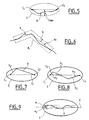
- the dynamic guidance system operates by modeling the roads of the road network. This modeling can be carried out in a compacted form, for example, by a function whose geometric representation approaches the reality of the road to be modeled, by end intersections and a maximum uncertainty which is a function of the distance between the two crossroads, the length of the road, and other parameters.
- the modeling process in a compact form of the road sections of the database is carried out when the cartographic database is constituted definitively.
- a road is a succession of elementary sections or vectors, connected end to end. The more complex the shape of the road, due to bends, the more it is necessary to finely cut the representation of the road, which generates a large number of vectors.
- the road is defined by the geographical coordinates of its ends, that is to say the initial intersection Ci and the final intersection C f , and by its actual length, which defines an ellipse E, d ' maximum uncertainty I max , in which the road R is necessarily situated as shown in FIG. 5.
- the modeling according to the invention makes it possible to significantly reduce the uncertainty on the position of the road without increasing the number of representative segments. For this, it takes into account the fact that a majority of roads have similar shapes, such as straight lines, one or two bends, arc of a circle ..., which can be classified into a small number of road models .
- the principle of this modeling consists in search, among the predefined models, the model closer to the route, by measuring the distance between the road and the model, according to a threshold adjustable in function of the precision sought, called quality of the model Q.
- the route R is composed of two segments S 0 and S 1 inside the ellipse E (FIG. 7).
- the road is made up of three segments, two extreme segments S 2 and S 3 starting from the crossroads ends, whose angles ⁇ 2 and ⁇ 3 of inclination are known relative to the axis of the ellipse d 'uncertainty, and an intermediate segment S 4 connecting them (Figure 8).
- All models can be known in advance from the central server and the on-board device. In this case, a simple model number is sufficient to identify it and only this identifier and the boundary conditions at the ends of each section of road are to be transmitted and stored. Otherwise, the route models must be transmitted to the on-board device with the other data, in a formalism understandable by the latter.
- Parametric modeling of network sections road is definitely done at the level of central server and the same level of service is offered to all users, be adapted dynamically and in real time on the one hand to constraints imposed by communication capacities and processing of the on-board device, and other share the needs of various users, such as precision of the application for example.
- the on-board device To enable this dynamic management of the modeling, the on-board device must communicate, in the request it sends to the remote server, specifications such as desired precision, possibly defined by category of axes, the on-board memory capacity available for save route models, or the ability to processing of models, in order to receive only models that can be treated.
- the server does then transmits the necessary elements, such as main crossroads for example or all crossroads, simple parametric models or complexes, etc ....
Landscapes
- Engineering & Computer Science (AREA)
- Radar, Positioning & Navigation (AREA)
- Remote Sensing (AREA)
- Physics & Mathematics (AREA)
- General Physics & Mathematics (AREA)
- Mathematical Physics (AREA)
- Automation & Control Theory (AREA)
- Navigation (AREA)
Abstract
Description
La présente invention concerne un système de guidage dynamique d'un véhicule, ainsi que les procédés de guidage réalisables grâce à ce système, exploitant les données cartographiques et les informations sur le trafic routier, reçues d'un serveur distant. Dans le but de limiter le temps de communication entre un dispositif embarqué sur le véhicule et le serveur distant, les données cartographiques envoyées par le serveur vers le véhicule sont codées à l'aide de modèles paramétriques de route.The present invention relates to a guidance system vehicle dynamics, as well as the guidance achievable thanks to this system, exploiting the cartographic data and information on the road traffic, received from a remote server. In the purpose of limiting the communication time between a on-board device on the vehicle and the server remote, the map data sent by the server to the vehicle are encoded using parametric road models.
Avec l'émergence des services télématiques liés aux nouvelles technologies de communication mobile, les systèmes de navigation offrant la possibilité d'un guidage dynamique doivent tenir compte des utilisateurs occasionnels de cette prestation de guidage, qui ne souhaitent pas investir dans un système dédié au guidage. De tels utilisateurs recherchent un système de navigation et d'informations routières de faible coût, pouvant éventuellement réutiliser un système embarqué existant dans le véhicule, tel qu'un module de téléphonie, un terminal du réseau Internet, un module d'appel d'urgence ou de gestion de flotte par exemple.With the emergence of telematic services linked to new mobile communication technologies, navigation systems offering the possibility of dynamic guidance must consider users occasional of this guidance service, which does not not want to invest in a system dedicated to guidance. Such users are looking for a low cost navigation and traffic information, possibly re-using an embedded system existing in the vehicle, such as a telephony, an Internet terminal, a module emergency call or fleet management for example.
Il existe actuellement des systèmes de guidage complètement autonome, de type CARIN de Philips, sans échange d'informations avec l'extérieur, ne permettant pas le calcul d'itinéraires tenant compte des situations de trafic routier en temps réel et dont la mise à jour de la cartographie embarquée impose le remplacement du support de données. There are currently guidance systems completely autonomous, Philips CARIN type, without exchange of information with the outside, not allowing not calculating routes taking into account road traffic situations in real time and the updating the on-board cartography requires the replacement of the data carrier.
D'autres systèmes de guidage autonomes reçoivent cependant de l'information de trafic routier d'un centre serveur par connexion à un radiotéléphone GSM par exemple, comme le système SOCRATES, mais le problème posé par la gestion du rapprochement des bases de données du réseau routier au format G.D.F. (Geographic Data File) et des informations trafic R.D.S.-T.M.C. (Radio Data System - Traffic Message Channel), qui s'appuie sur sa propre base de données, n'est pas résolu.Other autonomous guidance systems receive however traffic information from a server center by connection to a GSM radiotelephone for example, like the SOCRATES system, but the problem raised by the management of the reconciliation of the bases road network data in G.D.F. (Geographic Data File) and traffic information R.D.S.-T.M.C. (Radio Data System - Traffic Message Channel), which relies on its own database, is not resolved.
Il existe également des systèmes de guidage autonomes recevant des itinéraires dynamiques calculés par un centre serveur et transmis au véhicule, la base de données embarquée dans le véhicule servant surtout au guidage. Un exemple est décrit dans le brevet GB-3 206 738 de Mercedez-Benz, concernant un système de guidage dynamique dans lequel seule une liste de points de passage particuliers est envoyée au véhicule, pour éviter les difficultés de circulation dans le calcul des itinéraires, réalisé par le système embarqué. Cependant, les problèmes de mise à jour des bases de données et du coût du système demeurent.There are also autonomous guidance systems receiving dynamic routes calculated by a host and transmitted to the vehicle, the basis of data on board the vehicle used mainly for guidance. An example is described in the patent GB-3 206 738 from Mercedez-Benz, relating to a dynamic guidance in which only a list of points of particular passage is sent to the vehicle, for avoid traffic difficulties in the calculation routes, created by the on-board system. However, problems updating databases data and system cost remain.
Une solution est apportée par le système décrit dans la demande de brevet allemand DE-19531824 de V.D.O., qui transmet par le réseau G.S.M. l'itinéraire calculé par un serveur, ainsi que des consignes de guidage sous la forme de modes de franchissement de carrefours. Un inconvénient de ce système tient à la mauvaise qualité des consignes de guidage insuffisamment claires. De plus, la détermination de la position du véhicule sur le réseau routier, ainsi que la détection d'une sortie de l'itinéraire calculé sont impossibles, puisqu'aucune information sur la description des routes reliant les carrefours n'est transmise au véhicule.A solution is provided by the system described in the German patent application DE-19531824 by V.D.O., which transmits through the G.S.M. network the route calculated by a server, as well as guidance instructions under the form of crossing modes of crossroads. A disadvantage of this system is the poor quality insufficiently clear guidance instructions. Of plus, determining the vehicle's position on the road network, as well as the detection of an exit of the calculated route are impossible, since none information on the description of the roads connecting crossroads is not transmitted to the vehicle.
Le but de l'invention est de pallier ces inconvénients, en réalisant le téléchargement des cartographies, ou d'extraits de cartographies, basés sur des modèles paramétriques de route.The aim of the invention is to overcome these drawbacks, by downloading the maps, or extracts of maps, based on models parametric route.
Pour cela, un premier objet de l'invention est un système de guidage routier dynamique d'un véhicule, comprenant un dispositif embarqué dans le véhicule recevant des informations d'un serveur distant du véhicule, caractérisé en ce que ledit dispositif embarqué comprend :
- un premier module mobile de communication avec le serveur ;
- un module de localisation délivrant la position géographique du véhicule ;
- une mémoire destinée à stocker les données reçues du serveur distant ;
- un module de commande permettant la saisie des requêtes de l'utilisateur, à l'aide de boutons, d'une surface tactile, d'une boule de désignation, d'une télécommande ou d'un microphone ;
- un module de restitution de l'information trafic et/ou de présentation des informations de guidage ;
- une première unité de traitement électronique ;
- un second module fixe de communication avec le dispositif embarqué ;
- une base de données cartographiques détaillée ;
- une base de données cartographiques simplifiée ;
- une base de données d'informations sur le trafic routier ;
- une seconde unité de traitement électronique ;
- a first mobile communication module with the server;
- a location module delivering the geographic position of the vehicle;
- a memory intended to store the data received from the remote server;
- a control module for entering user requests, using buttons, a touchscreen, a designation ball, a remote control or a microphone;
- a module for rendering traffic information and / or presenting guidance information;
- a first electronic processing unit;
- a second fixed communication module with the on-board device;
- a detailed cartographic database;
- a simplified cartographic database;
- a road traffic information database;
- a second electronic processing unit;
La cartographie simplifiée, basée sur des modèles paramétriques de routes, est générée à partir de la cartographie détaillée.Simplified mapping, based on models parametric of routes, is generated from the detailed mapping.
Ce système de guidage selon l'invention peut être obtenu à partir de plusieurs modes de réalisation.This guidance system according to the invention can be obtained from several embodiments.
D'autres objets de l'invention concernent des procédés de guidage d'un véhicule équipé par un des modes de réalisation du système de guidage.Other objects of the invention relate to methods for guiding a vehicle equipped with one of the realization of the guidance system.
D'autres caractéristiques et avantages de l'invention apparaítront à la lecture de la description de plusieurs exemples de réalisation, non limitatifs, illustrée par les figures suivantes qui sont :
- la figure 1 : un schéma de l'architecture fonctionnelle du système de guidage dynamique selon l'invention ;
- la figure 2 : un schéma fonctionnel d'un exemple de réalisation du système selon l'invention, dans lequel le calcul d'itinéraire est effectué par un serveur distant uniquement ;
- la figure 3 : un schéma fonctionnel d'un exemple de réalisation du système selon l'invention, dans lequel le calcul d'itinéraire est effectué par un serveur distant et partiellement par le dispositif embarqué ;
- la figure 4 : un schéma fonctionnel d'un exemple de réalisation du système selon l'invention, dans lequel le calcul d'itinéraire est effectué par un dispositif embarqué uniquement ;
- figure 5 : un exemple de réalisation d'une route dans une base de données simplifiée ;
- les figures 6 à 9 : des exemples non limitatifs de modélisation du réseau routier dans une base de données simplifiée.
- Figure 1: a diagram of the functional architecture of the dynamic guidance system according to the invention;
- Figure 2: a block diagram of an exemplary embodiment of the system according to the invention, in which the route calculation is performed by a remote server only;
- FIG. 3: a functional diagram of an exemplary embodiment of the system according to the invention, in which the route calculation is carried out by a remote server and partially by the on-board device;
- FIG. 4: a functional diagram of an exemplary embodiment of the system according to the invention, in which the route calculation is carried out by an on-board device only;
- FIG. 5: an exemplary embodiment of a route in a simplified database;
- Figures 6 to 9: non-limiting examples of modeling the road network in a simplified database.
Les éléments portant les mêmes références dans les différentes figures remplissent les mêmes fonctions en vue des mêmes résultats.Items with the same references in the different figures perform the same functions by view of the same results.
Selon l'architecture fonctionnelle représentée sur la
figure 1, le système de guidage dynamique d'un véhicule
selon l'invention est composé d'un dispositif 1
embarqué sur le véhicule et d'un serveur 2 distant,
extérieur au véhicule.According to the functional architecture represented on the
Figure 1, the dynamic guidance system of a vehicle
according to the invention is composed of a
Le dispositif embarqué 1 comprend :
- un
premier module 3 mobile de communication avec leserveur 2, selon une communication unidirectionnelle ou bidirectionnelle selon les cas décrits par la suite, qui peut être basé par exemple sur un réseau de téléphonie cellulaire comme le réseau G.S.M. permettant l'échange de paroles et de données entre le serveur distant et le dispositif embarqué ; - un
module 4 de localisation mobile, délivrant la position géographique du véhicule ; - une
mémoire 5 destinée à stocker les données envoyées par le serveur distant ; - un
module 6 de commande, permettant à l'utilisateur de saisir des requêtes, comme le guidage vers une destination, composé par exemple d'un ensemble de boutons, d'une surface tactile, d'une boule de désignation, - "track ball" en vocable anglo-saxon -, d'une télécommande, ou bien encore d'un microphone qui capte les paroles de l'utilisateur ; - un
module 7 de restitution de l'information sur le trafic routier et/ou de présentation des informations de guidage à l'utilisateur, constitué d'un haut-parleur pour la diffusion des informations sonores, éventuellement complété d'un afficheur pour la présentation des données textuelles ou graphiques ; - une première unité de traitement électronique 8, qui réalise la prestation de guidage notamment.
- a first
mobile module 3 for communication with theserver 2, according to a unidirectional or bidirectional communication according to the cases described below, which can be based for example on a cellular telephone network such as the GSM network allowing the exchange of words and data between the remote server and the on-board device; - a
mobile location module 4, delivering the geographic position of the vehicle; - a
memory 5 intended to store the data sent by the remote server; - a
control module 6, allowing the user to enter requests, such as guidance to a destination, composed for example of a set of buttons, a tactile surface, a designation ball, - "track ball "in Anglo-Saxon terms -, a remote control, or even a microphone which picks up the user's words; - a
module 7 for rendering information on road traffic and / or for presenting guidance information to the user, consisting of a loudspeaker for broadcasting sound information, possibly supplemented by a display for presenting textual or graphic data; - a first
electronic processing unit 8, which performs the guidance service in particular.
Quant au serveur distant 2, il est composé de :
- un second module 9 fixe de communication avec le dispositif embarqué 1 ;
- une base de donnée cartographiques 10 détaillée du réseau routier ;
- une base de données cartographiques 11 simplifiée du réseau routier ;
- une base de données 12 d'informations sur le trafic routier ;
- une seconde unité de traitement électronique 13
destinée à interpréter les requêtes émises par
l'utilisateur, transmises par le
premier module 3 de communication du dispositif embarqué 1 et reçues par le second module 9 de communication du serveur 2, et à les satisfaire.
- a second fixed module 9 for communication with the on-
board device 1; - a detailed
cartographic database 10 of the road network; - a simplified
cartographic database 11 of the road network; - a
database 12 of road traffic information; - a second
electronic processing unit 13 intended to interpret the requests sent by the user, transmitted by thefirst communication module 3 of the on-board device 1 and received by the second communication module 9 of theserver 2, and to satisfy them.
Les bases de données cartographiques détaillée 10 d'une
part et concernant le trafic routier 12 d'autre part
peuvent être extérieures au serveur distant 2 et
accessibles par un réseau de télécommunication, par
exemple au travers d'Internet. The detailed
De plus, la base de données cartographiques 11
simplifiée et la base de données 12 d'informations
routières peuvent être confondues.In addition, the
La cartographie simplifiée du réseau routier est obtenue par modélisation des routes, de sorte qu'elle n'occupe pas une mémoire de grande taille. Dans le dispositif embarqué, il n'est pas nécessaire de disposer de cartographies couvrant une région de grande superficie ; en effet, selon la position du véhicule et sa destination donnée par l'utilisateur, seule la cartographie utile peut être téléchargée du serveur distant vers le véhicule, cette cartographie pouvant même se réduire à un itinéraire.The simplified cartography of the road network is obtained by modeling roads, so that it does not occupy a large memory. In the on-board device, there is no need to have maps covering a large area area; indeed, depending on the position of the vehicle and its destination given by the user, only the useful mapping can be downloaded from the server distant towards the vehicle, this mapping being able even be reduced to a route.
Grâce à cette cartographie modélisée ou simplifiée, les modèles paramétriques de route limitent fortement le nombre de données cartographiques à transmettre, ce qui a pour avantage de réduire les temps et les coûts de communication entre le serveur et le véhicule. A titre d'exemple, dans une base de données détaillée classique, la couverture de la région Ile-de-France nécessite une capacité de stockage d'environ 20 méga-octets. Par contre, si on utilise une base de données simplifiée basée sur les modèles paramétriques de routes, elle occupe seulement 200 kilo-octets pour la même région, sans dégrader la qualité de la prestation de guidage du système.Thanks to this modeled or simplified cartography, parametric road models severely limit the number of map data to be transmitted, which has the advantage of reducing the time and costs of communication between the server and the vehicle. As example, in a detailed database classic, the coverage of the Ile-de-France region requires a storage capacity of approximately 20 megabytes. On the other hand, if we use a database simplified based on parametric models of routes, it occupies only 200 kilobytes for the same region, without degrading the quality of the service system guidance.
Le dispositif embarqué 1 peut être utilisé pour
plusieurs autres prestations que celles de guidage,
comme la gestion de flotte, l'appel d'urgence ou autres
applications télématiques, ce qui réduit d'autant son
coût. The on-
La figure 2 est un schéma fonctionnel d'un premier exemple de réalisation du système de guidage dynamique selon l'invention, dans lequel le calcul d'itinéraire est effectué par le serveur distant.Figure 2 is a block diagram of a first example of the dynamic guidance system according to the invention, in which the route calculation is performed by the remote server.
Selon ce mode de réalisation particulier, dans le
dispositif embarqué 1 dans le véhicule, le premier
module 3 de communication mobile est bidirectionnel,
permettant l'échange réciproque de paroles et de
données entre le système embarqué et le serveur
distant.According to this particular embodiment, in the
on-
La mémoire 5, de taille limitée, stocke les données
reçues du serveur distant 2, c'est-à-dire l'itinéraire
optimal calculé avec les modèles de routes utiles pour
reconstituer les routes à partir de la base de données
cartographiques simplifiée. Pour cela, elle peut
comprendre une zone spécifique de stockage des messages
vocaux envoyés par le serveur.
La première unité de traitement électronique 8 assure
le suivi de position du véhicule sur l'itinéraire,
grâce à un module 16.The first
Dans le serveur distant 2, le second module 9 de
communication est bidirectionnel.In
La seconde unité de traitement électronique 13 comprend
d'une part un module 14 d'interprétation des requêtes
de l'utilisateur, qu'elles soient sous forme vocale ou
non, envoyées par le premier module 3 de communication
du dispositif embarqué 1. Il peut être constitué de
moyens de reconnaissance de parole, éventuellement
complétés par un opérateur pour le cas où les
algorithmes de reconnaissance de la parole
échoueraient.The second
Elle comprend d'autre part un module 15 de calcul d'un
itinéraire optimal, à partir des données issues de la
base de données cartographiques 11 simplifiée et de la
base de données 12 d'information trafic.It also includes a
Le procédé de fonctionnement de ce mode de réalisation particulier comprend les phases suivantes.The operating method of this embodiment particular includes the following phases.
Une première phase de demande de guidage par
l'utilisateur du véhicule, réalisée par le dispositif
embarqué 1, comprend une étape d'établissement d'une
communication entre son module de communication et
celui du serveur distant.A first phase of guidance request by
the vehicle user, performed by the device
on-
L'utilisateur compose ensuite une requête, comprenant
principalement la destination vers laquelle
l'utilisateur veut être guidé, ainsi que plusieurs
points de passage spécifiés éventuellement. Cette
requête, établie à l'aide du module 6 de commande, se
présente sous la forme de signaux électriques
correspondant aux touches d'un clavier ou
préférablement de paroles converties en signaux
électriques par un microphone.The user then composes a request, comprising
mainly the destination to which
the user wants to be guided, as well as several
waypoints specified if necessary. This
request, established using the
Les signaux électriques correspondants sont émis d'un
module de communication à l'autre, en utilisant un
canal d'échange de paroles ou de données.
Simultanément, le module 4 de localisation envoie
également la position actuelle du véhicule. The corresponding electrical signals are emitted from a
communication module to each other, using a
speech or data exchange channel.
Simultaneously, the
Une seconde phase de calcul de l'itinéraire demandé par
l'utilisateur entre la position actuelle du véhicule et
sa destination donnée est réalisée par le serveur
distant et consiste tout d'abord en une interprétation
de la requête de l'utilisateur par le module 14, qui la
traduit en commandes compréhensibles par le module 15
de calcul de l'itinéraire. Dans le cas le plus
ergonomique où la requête est composée de paroles, elle
est interprétée par des moyens de reconnaissance de la
parole inclus dans le module 14. Un opérateur peut
traduire manuellement la commande vocale si ces
derniers sont défectueux.A second phase of calculating the route requested by
the user enters the current vehicle position and
its given destination is performed by the server
distant and consists first of all of an interpretation
of the user's request by
Ainsi, le module 15 de calcul d'un itinéraire optimal
reçoit cette requête principalement composée de la
destination vers laquelle l'utilisateur souhaite être
guidé, avec éventuellement des points de passage, et la
localisation actuelle du véhicule. Ce module 15
interroge les bases de données cartographiques 11 et
d'information trafic 12 pour en déduire un itinéraire
optimal en temps et en distance.Thus, the
Cet itinéraire est constitué de coordonnées géographiques de points du réseau routier, comme les carrefours, et de tronçons décrits à l'aide de modèles paramétriques de route. A chaque point et à chaque tronçon sont associées des informations textuelles ou vocales correspondant aux directions à suivre, la distance des points du réseau à laquelle devront être émises les informations vocales, et la longueur de ces messages vocaux.This route consists of coordinates geographic points of the road network, such as crossroads, and sections described using models parametric route. At each point and at each section are associated with text information or corresponding to the directions to follow, the distance from the points of the network to which must be voice information, and the length of these voice messages.
Puis, le module 9 de communication transmet ces
informations au module 3 du dispositif embarqué, au
moyen du canal vocal et du canal des données
numériques.Then, the communication module 9 transmits these
information in
Une troisième phase consiste alors à mémoriser, par le
dispositif embarqué 1, toutes ces informations
transmises par le serveur distant 2, dans la mémoire 5.
Un module 16 de suivi de position, appartenant à la
première unité de traitement 8, reconstitue les routes
de l'itinéraire à partir des modèles paramétriques
transmis par le serveur distant et stockés dans ladite
mémoire. Cette opération peut aussi être réalisée par
la transmission, par le serveur, d'un simple
identificateur permettant de pointer sur une liste de
modèles préalablement connus du système embarqué,
stockée dans la mémoire prévue à cet effet. La route
est déterminée par application du modèle aux autres
données définissant la route, telles que l'équation de
la route, ses paramètres, les conditions aux
extrémités, etc ... .A third phase then consists in memorizing, by
on-
Disposant de la forme des routes de l'itinéraire
calculé et de la localisation du véhicule fournie par
le module 4, le suivi de position est alors capable
d'identifier l'axe sur lequel circule le véhicule et sa
position sur cet axe en vue de son guidage vers la
destination désignée.Layout of route routes
calculated and the location of the vehicle provided by
Le module 16 de suivi de position effectue la
comparaison entre le trajet du véhicule et l'itinéraire
calculé stocké dans la mémoire 5. Dès que la distance
entre la localisation et un point de décision courant
est inférieure aux distances de présentation de message
également stockées dans la mémoire 5, le module de
suivi de position commande au module 7 de présentation
des informations l'affichage des indications textuelles
correspondantes et l'émission du message vocal.The
L'utilisateur peut demander à tout moment la réémission
ou un nouvel affichage des messages précédents à l'aide
du module 6 de saisie de requêtes.User can request reissue at any time
or a new display of previous messages using
of
Il peut de plus détecter une sortie de cet itinéraire
et en avertir l'utilisateur par des indications
visuelles et sonores.
En effet, il vérifie que le véhicule suit le trajet
conseillé à l'aide des modèles paramétriques des
tronçons routiers. Dans le cas contraire, l'utilisateur
peut rejoindre l'itinéraire conseillé grâce notamment à
une indication de direction vers un point de cet
itinéraire, sous forme d'affichage d'une flèche
graphique par exemple. Dans une autre version,
l'utilisateur peut envoyer une nouvelle requête de
guidage vers le serveur distant 2 qui recalculera alors
un nouvel itinéraire.It can also detect an exit from this route and warn the user by visual and audible indications.
Indeed, it checks that the vehicle follows the recommended route using parametric models of the road sections. Otherwise, the user can join the recommended route thanks in particular to an indication of direction towards a point of this route, in the form of display of a graphic arrow for example. In another version, the user can send a new guidance request to the
La figure 3 est un schéma fonctionnel d'un deuxième exemple de réalisation du système selon l'invention, dans lequel le calcul d'itinéraire est effectué par le serveur distant, avec possibilité pour le dispositif embarqué de calculer lui-même un itinéraire dans une bande localisée autour de l'itinéraire principal.Figure 3 is a block diagram of a second exemplary embodiment of the system according to the invention, in which the route calculation is carried out by the remote server, with possibility for the device embedded to calculate a route itself in a strip located around the main route.
Pour cela, un extrait de la cartographie simplifiée,
stockée dans le serveur distant 2, est transmis au
dispositif embarqué dans le véhicule, cet extrait
correspondant à une bande de déplacement autour de
l'itinéraire calculé, qui couvre d'éventuels
déplacements de l'utilisateur hors de cet itinéraire. For this, an extract from the simplified cartography,
stored in
Grâce à cette bande cartographiée, mémorisée dans le
dispositif embarqué 1, ce dernier peut calculer un
itinéraire ramenant le véhicule vers l'itinéraire
initial et le guider grâce aux indications de guidage
contenues dans cet extrait de cartographie.Thanks to this mapped strip, memorized in the
on-
L'utilisation du modèle paramétrique de routes réduit considérablement la taille de l'extrait de cartographie correspondant à cette bande de déplacement, tout en maintenant une bonne qualité de suivi de position et de guidage, avec un coût de communication réduit.The use of the reduced parametric model of roads considerably the size of the map extract corresponding to this displacement band, while now a good quality of position tracking and guidance, with a reduced communication cost.
Selon ce deuxième mode particulier de réalisation du
système de guidage, le premier module 3 de
communication du dispositif embarqué assure la
communication mobile et bidirectionnelle avec le
serveur distant 2, le module 4 fournit la localisation
du véhicule en temps réel, le module 6 permet la saisie
des requêtes de l'utilisateur qui sont interprétées par
un module 17 de l'unité de traitement électronique 8,
au niveau du dispositif embarqué 1.According to this second particular embodiment of the
guidance system, the
Cette même unité de traitement comprend de plus un
module 16 de suivi de position du véhicule sur
l'itinéraire, ainsi qu'un module 18 de calcul embarqué
d'un itinéraire à partir de l'extrait de cartographie
simplifiée envoyée par le serveur et couvrant une bande
de déplacement autour de l'itinéraire calculé par le
serveur. Un module 7 assure la présentation des
informations de guidage à l'utilisateur, par synthèse
vocale et afficheur pour les données textuelles ou
graphiques. La mémoire 5 comprend une première zone 19
pour la mémorisation des données concernant
l'itinéraire, reçues du serveur 2, et une deuxième zone
20 pour mémoriser les modèles de routes utiles pour
reconstituer les routes de l'itinéraire à partir de la
cartographie simplifiée 11, et un extrait de cette même
cartographie simplifiée 11 correspondant à la bande de
déplacement du véhicule autour de l'itinéraire calculé.This same processing unit further includes a
vehicle
Quant au serveur 2 distant du véhicule, il comprend les
mêmes éléments que dans le premier mode de réalisation
décrit à propos de la figure 2, avec un module 9
assurant une communication fixe bidirectionnelle.As for the
Le procédé de fonctionnement de ce deuxième mode de réalisation particulier comprend une première phase de demande de guidage, par l'utilisateur du véhicule, jusqu'à une destination qu'il indique avec éventuellement des points de passage, à partir de sa localisation actuelle. Cette première phase est identique à la première phase du mode de réalisation précédent du système de guidage.The operating method of this second mode of particular realization includes a first phase of guidance request, by the vehicle user, to a destination it indicates with possibly crossing points, from its current location. This first phase is identical to the first phase of the embodiment guidance system.
Le procédé comprend une deuxième phase de calcul d'un
itinéraire optimal à partir de la base de données
cartographiques simplifiée 11 et de la base de données
12 d'information trafic, réalisée de la même façon par
le module 15 de calcul d'itinéraire que lors du premier
mode de réalisation du système.The method comprises a second phase of calculating a
optimal route from the database
simplified
Par contre, ce module 15 de calcul détermine également
une bande de déplacement autour de l'itinéraire
préalablement calculé, qui est un extrait de la
cartographie simplifiée 11. Cette bande de déplacement
peut être définie selon des critères géométriques,
comme la largeur de bande, qui peut diminuer quand on
se rapproche du point de destination, par exemple. Elle
peut aussi être établie en fonction de la longueur de
l'itinéraire, sa largeur étant d'autant plus étroite
que l'itinéraire est long, pour limiter la quantité de
données à transmettre et réaliser ainsi un compromis
entre qualité de prestation et coût du service offert à
l'utilisateur.However, this
Une quatrième phase de guidage dynamique, réalisée par
le dispositif embarqué 1, comprend tout d'abord la mise
en mémoire de l'itinéraire calculé dans la première
zone 19 et de la bande de déplacement dans la deuxième
zone 20. Comme précédemment, le guidage consiste
ensuite en une reconstitution des routes de
l'itinéraire par le module 16 de suivi de position,
l'identification de la route de circulation du véhicule
et la délivrance des indications de guidage vers la
destination si l'unité de traitement 8 vérifie que le
véhicule se trouve bien sur l'itinéraire calculé.A fourth dynamic guidance phase, carried out by
the on-
Cette vérification est le résultat d'une comparaison entre le trajet réellement suivi par le véhicule et l'itinéraire calculé à l'aide des modèles paramétriques de routes.This verification is the result of a comparison between the route actually followed by the vehicle and the route calculated using parametric models of roads.
Si l'utilisateur circule hors de l'itinéraire, mais sur
un axe de la bande de déplacement définie autour de
l'itinéraire, le module 18 recalcule un itinéraire pour
le guider vers l'itinéraire initial puis sa
destination.If the user is traveling off the route, but on
an axis of the displacement band defined around
the route,
Si l'utilisateur circule hors de la bande de
déplacement, le module 7 de présentation d'informations
peut l'aider à y revenir par affichage d'une flèche
indiquant la direction d'un point de la bande ou la
destination.If the user is traveling outside the
displacement,
Selon une autre version, l'utilisateur lui-même peut
envoyer une nouvelle requête de guidage vers le serveur
distant 2, pour un calcul d'un nouvel itinéraire avec
une nouvelle bande de déplacement.According to another version, the user himself can
send a new guidance request to the
Dans le cas où le module 16 de suivi de position ne
parvient pas à localiser le véhicule sur un des axes
modélisés, bien que celui-ci circule dans la bande de
déplacement, car toutes les voies de circulation ne
sont pas obligatoirement incluses dans la cartographie
simplifiée, le dispositif embarqué aide le conducteur à
revenir sur le réseau des routes incluses, par
affichage d'une flèche indiquant un point de la bande
de déplacement ou la destination.In the case where the
Le système de guidage dynamique selon l'invention peut également être réalisé selon un troisième mode particulier, dans lequel l'essentiel du guidage est effectué par le dispositif embarqué, alors que le rôle du serveur distant est de transmettre les bases de données cartographiques mises à jour. La durée de transmission est relativement courte grâce aux modèles paramétriques de routes.The dynamic guidance system according to the invention can also be realized according to a third mode particular, in which most of the guidance is performed by the on-board device, while the role from the remote server is to transmit the basics of updated map data. The duration of transmission is relatively short thanks to the models parametric routes.
La figure 4 est un schéma fonctionnel de ce troisième
mode de réalisation de l'invention. Le dispositif
embarqué comprend un module 3 de communication, qui est
unidirectionnel autorisant une communication du serveur
vers le véhicule dans un premier cas, représentée par
une simple flèche en pointillés. Il peut être basé sur
les modes de diffusion de données, comme le protocole
SWIFT pour les émissions radiophoniques en modulation
de fréquence, ou le D.A.B. par exemple.Figure 4 is a block diagram of this third
embodiment of the invention. The device
on-board includes a
Dans un deuxième cas, le module 3 n'est plus seulement
un récepteur mais est basé sur un mode d'échanges de
données prévus dans certains réseaux cellulaires de
téléphonie, comme le réseau G.S.M., autorisant une
communication bidirectionnelle point à point entre le
dispositif embarqué et le serveur, représentée
symboliquement par une double flèche en trait plein.In a second case,
Comme pour les précédents modes de réalisation, le
dispositif embarqué comprend un module 6 de saisie des
requêtes de l'utilisateur, un module 7 de présentation
des informations de guidage dans le véhicule, un module
4 de localisation du véhicule en temps réel, une unité
de traitement électronique 8 comprenant un module 17
d'interprétation des requêtes reçues du module de
saisie, un module 18 de calcul d'un itinéraire optimal
à partir des commandes envoyées par le module 17 et des
informations stockées dans la mémoire 5, et un module
16 de suivi de position du véhicule à partir de sa
localisation, des modèles de routes et de la
cartographie simplifiée mémorisés.As for the previous embodiments, the
on-board device includes a
La mémoire 5 est composée d'une première zone 19 où
sont stockées diverses informations comme le trafic
routier, une deuxième zone 20 où est stockée la
cartographie simplifiée provenant de la base de données
11 du serveur 2, et une troisième zone 21 où sont
stockés les modèles de routes qui peuvent être
téléchargés en même temps que la cartographie
simplifiée. The
Le serveur distant 2 est composé dans un premier cas
d'un émetteur, de type SWIFT, DAB, etc ..., diffusant
des données, et dans un deuxième cas d'un émetteur-récepteur
compatible avec les protocoles d'échange de
données des réseaux de radiotéléphonie cellulaire.The
Il comporte également les mêmes bases de données que les exemples de réalisation précédents et une deuxième unité de traitement électronique.It also has the same databases as the previous examples and a second electronic processing unit.
Le procédé de fonctionnement de ce troisième mode de
réalisation particulier d'un système de guidage selon
l'invention est basé sur la transmission de la base de
données cartographiques simplifiée 11 au dispositif
embarqué 1 dans le véhicule, qui va effectuer le calcul
d'itinéraire optimal lui-même ainsi que le guidage
dynamique du véhicule.The operating method of this third mode of
particular embodiment of a guidance system according to
the invention is based on the transmission of the base of
Dans le premier cas où le module 3 est unidirectionnel
du serveur vers le véhicule, la première partie du
procédé consiste à transmettre périodiquement la
cartographie simplifiée du serveur distant 2 au
dispositif embarqué 1, qui la stocke dans la deuxième
zone 20 de la mémoire 5. Cette cartographie est remise
à jour périodiquement par le serveur dont le module 9
de communication réalise l'émission rapide, grâce au
fait que cette cartographie simplifiée 11 utilise des
modèles paramétriques de route. Ainsi, la mémoire 5
peut stocker une zone géographique étendue, telle que
le territoire d'un pays, pouvant être définie comme un
disque de rayon déterminé ayant pour centre le module 9
d'émission du serveur 2. In the first case where
Le premier module 3 de communication unidirectionnelle
du véhicule scrute régulièrement les données envoyées
par le serveur distant et compare la version de la
cartographie modélisée émise, définie par son numéro ou
sa date de modification, avec la version sauvegardée
dans la deuxième mémoire 20. Si la version mémorisée
est antérieure à la version émise, elle est remplacée
par cette dernière dans la mémoire.The first
Il est possible de structurer la cartographie
simplifiée du réseau routier en zones géographiques,
comme les départements d'un pays par exemple. Dans ce
cas, les numéros de version sont gérés pour chaque zone
de découpage remise à jour et le module 3 de réception
du véhicule effectue la comparaison entre la version
mémorisée et la version envoyée pour chacune d'elles.
Un intérêt de cette possibilité est l'émission plus
fréquente des zones géographiques voisines de
l'émetteur.It is possible to structure the mapping
simplified road network in geographic areas,
like the departments of a country for example. In this
case, the version numbers are managed for each zone
cutting module updated and receiving
Selon le second cas de ce troisième mode de réalisation
pour lequel les modules 3 et 9 de communication entre
le véhicule et le serveur sont des émetteurs-récepteurs
compatibles avec un réseau radiotéléphonique
cellulaire, le module 9 du serveur peut contacter le
véhicule pour l'avertir qu'une nouvelle version de la
base de données est disponible et le module 3 du
dispositif embarqué 1 peut joindre le serveur pour
demander un téléchargement de la base de données
cartographiques.According to the second case of this third embodiment
for which
La seconde partie du procédé de fonctionnement de ce troisième mode de réalisation est la réalisation du guidage dynamique du véhicule selon une procédure classique.The second part of the operating process of this third embodiment is the realization of the dynamic vehicle guidance according to a procedure classic.
En permanence, le module 3 de communication du
dispositif embarqué 1 scrute les informations routières
envoyées par le serveur 2 et les stocke dans une zone
mémoire temporaire 21.The
Quand l'utilisateur compose une requête de guidage
comprenant la destination et éventuellement quelques
points de passage, cette requête est interprétée par le
module 17 qui délivre des commandes à l'unité de
traitement 8. Le module 18 de calcul d'itinéraire
reçoit les informations stockées dans la mémoire 5,
concernant le trafic routier et la cartographie, et
détermine l'itinéraire optimal à partir de la position
du véhicule localisée grâce au module 4 de
localisation, éventuellement affinée par le module 16
de suivi de position.When the user composes a guidance request
including the destination and possibly some
waypoints, this request is interpreted by the
Le calcul d'itinéraire étant fait, le guidage a lieu et
le module 16 de suivi de position du véhicule
reconstitue les routes autour de sa position. Pour
cela, il cherche, dans une liste stockée dans la
troisième zone mémoire 21, le modèle correspondant à
l'identificateur du modèle transmis pour chaque route
par le serveur 2.The route calculation being made, the guidance takes place and
the vehicle
Comme cela a été décrit pour le deuxième mode de
réalisation, le guidage consiste, après cette
reconstitution des routes de l'itinéraire et
l'identification de la route de circulation du
véhicule, à délivrer des indications de guidage si
l'unité de traitement 8 a vérifié que le véhicule
circule bien sur l'itinéraire calculé. Cette
vérification est identique à celle déjà décrite.As described for the second mode of
realization, the guidance consists, after this
route reconstruction of the route and
the identification of the traffic route of the
vehicle, to issue guidance indications if
the
Le troisième mode de réalisation peut être basé, selon
une autre variante, sur la transmission de la base de
données cartographiques simplifiée, décomposée en au
moins deux niveaux, un premier niveau dénommé "base de
données globale" qui comprend essentiellement les
grands axes de circulation sur une zone géographique
étendue, et un deuxième niveau appelé "base de données
locale" qui comprend une zone limitée au voisinage du
module émetteur 9 du serveur 2.The third embodiment can be based, depending on
another variant, on the transmission of the base of
simplified cartographic data, broken down into au
minus two levels, a first level called "base of
global data "which basically includes
major traffic axes in a geographical area
scope, and a second level called "database
locale "which includes a limited area in the vicinity of
server 9
La phase de transmission de cette base de données à
deux niveaux se déroule de la manière suivante : tout
d'abord, le module 9 transmet périodiquement la base de
données globale contenant principalement les grands
axes et permettant par exemple de relier les villes
entre elles, constituant ainsi une base de données
interurbaine. Cette base globale peut s'étendre à une
zone très étendue, telle un continent comme l'Europe,
grâce aux modèles paramétriques de routes. Comme dans
la variante précédente, le dispositif embarqué 1
compare la version de la cartographie mémorisée avec la
version émise et la remplace au besoin.The transmission phase of this database to
two levels takes place as follows: everything
first, the module 9 periodically transmits the base of
global data containing mainly large
axes and allowing for example to connect cities
between them, thus constituting a database
long distance. This overall base can extend to a
very large area, like a continent like Europe,
using parametric route models. As in
the previous variant, the on-
Puis, le module 9 de communication diffuse également
une cartographie plus détaillée d'une zone limitée
autour de l'émetteur de chaque serveur, correspondant
par exemple à une ville rencontrée sur le parcours du
véhicule. Il transmet un identificateur correspondant
au nom de la ville et un numéro de version pour
permettre au dispositif embarqué de mettre à jour la
base de données sauvegardée dans la deuxième zone
mémoire 20. Ainsi, à l'approche d'une ville, l'unité de
traitement du dispositif embarqué compare la
cartographie sauvegardée dans la mémoire 5 à celle qui
est reçue et la remplace par celle-ci, automatiquement
ou après confirmation de l'utilisateur, si ces
cartographies sont différentes.Then, the communication module 9 also broadcasts
more detailed mapping of a limited area
around the transmitter of each server, corresponding
for example to a city encountered on the course of the
vehicle. It transmits a corresponding identifier
on behalf of the city and a version number for
allow the on-board device to update the
database saved in the
La phase de guidage dynamique se déroule différemment dans une zone locale et dans une zone plus étendue.The dynamic guidance phase takes place differently in a local area and in a larger area.
Si la destination désignée par l'utilisateur se situe dans la base de donnée locale, la procédure est identique à celle décrite dans la première variante du troisième mode de réalisation.If the destination designated by the user is located in the local database, the procedure is identical to that described in the first variant of third embodiment.
Par contre, si la destination choisie se situe au-delà
de la zone locale autour du serveur 2, par exemple dans
une ville différente de la ville où est localisé le
véhicule actuellement, la procédure consiste tout
d'abord à établir une requête de guidage avec saisie de
la destination à l'aide du module 6, en précisant la
ville et l'adresse en question. Le module 17 interprète
cette requête et commande le module 18 qui calcule un
itinéraire optimal à partir de la base de données
globale mémorisée dans la deuxième zone mémoire 20, de
la base de données locale correspondant à la ville
d'origine mémorisée dans la zone 19 et des informations
sur le trafic routier stockées dans la troisième zone
mémoire 21, itinéraire destiné à rejoindre la ville de
destination par les grands axes routiers. L'adresse de
destination est stockée dans la mémoire locale 19 sans
être interprétée. Le guidage dynamique entre la
localisation actuelle du véhicule et la ville de
destination est identique au guidage décrit
précédemment.On the other hand, if the chosen destination is beyond
of the local area around
A proximité de la ville de destination, le module 3 de
communication du dispositif embarqué 1 reçoit, du
serveur 2, la base de données locale correspondant au
réseau routier de la région entourant le serveur, et la
stocke dans la deuxième zone mémoire 20 de la mémoire
5. Le module 18 de calcul d'itinéraire compare
l'adresse de destination mémorisée au début du trajet
avec les adresses de la base de données locale. Si
l'adresse spécifiée est inconnue dans cette base, le
module 18 le signale à l'utilisateur qui doit entrer à
nouveau la destination souhaitée. Ensuite, le module 18
calcule l'itinéraire optimal jusqu'à la destination et
effectue le guidage décrit auparavant.Close to the destination city,
Dans le cas où la destination, que ce soit une adresse ou un nom de ville, ne se situe ni dans la base de données globale ni dans la base de données locale, l'utilisateur peut saisir un point de passage parmi ceux connus du dispositif embarqué dans une liste sauvegardée, affichée à la demande. Ce sont par exemple les villes frontières situées à la limite de la base de données embarquée.In case the destination, be it an address or a city name, is neither in the base of global data or in the local database, the user can enter a waypoint among those known to the embedded device in a list saved, displayed on demand. These are for example the border towns located at the limit of the base of embedded data.
Selon une variante du procédé, au lieu de désigner au départ l'adresse de destination qui est analysée dès que le dispositif embarqué reçoit la base de données locale au voisinage de la destination, l'utilisateur ne précise que la ville de destination lors de la requête initiale et, lorsque le dispositif embarqué reçoit la base de données locale à proximité de la destination, il demande à l'utilisateur de saisir l'adresse de la destination.According to a variant of the process, instead of designating departure the destination address which is analyzed from that the on-board device receives the database local to the destination, the user does not specifies that the city of destination during the request initial and when the on-board device receives the local database near the destination, it asks the user to enter the address of the destination.
Le système de guidage dynamique selon l'invention
fonctionne grâce à la modélisation des routes du réseau
routier.
Cette modélisation peut s'opérer sous une forme
compactée, par exemple, par une fonction dont la
représentation géométrique s'approche de la réalité de
la route à modéliser, par des carrefours d'extrémité et
une incertitude maximale qui est fonction de la
distance entre les deux carrefours, de la longueur de
la route, et d'autres paramètres.The dynamic guidance system according to the invention operates by modeling the roads of the road network.
This modeling can be carried out in a compacted form, for example, by a function whose geometric representation approaches the reality of the road to be modeled, by end intersections and a maximum uncertainty which is a function of the distance between the two crossroads, the length of the road, and other parameters.
Le processus de modélisation sous une forme compacte des tronçons routiers de la base de données, est réalisé lors de la constitution de la base de données cartographiques de façon définitive. Dans une base de données de type GDF, une route est une succession de tronçons élémentaires ou vecteurs, reliés bout à bout. Plus la forme de la route est complexe, en raison de virages, plus il faut découper finement la représentation de la route, ce qui génère un nombre important de vecteurs. Dans un système simplifié, la route est définie par les coordonnées géographiques de ses extrémités, c'est-à-dire le carrefour initial Ci et le carrefour final Cf, et par sa longueur réelle, ce qui définit une ellipse E, d'incertitude maximale Imax, dans laquelle se situe obligatoirement la route R comme le montre la figure 5. La modélisation selon l'invention permet de réduire sensiblement l'incertitude sur la position de la route sans augmenter le nombre de segments représentatifs. Pour cela, elle tient compte du fait qu'une majorité de routes ont des formes similaires, telles que lignes droites, un ou deux coudes, arc de cercle ..., que l'on peut classer en un petit nombre de modèles de route.The modeling process in a compact form of the road sections of the database, is carried out when the cartographic database is constituted definitively. In a GDF type database, a road is a succession of elementary sections or vectors, connected end to end. The more complex the shape of the road, due to bends, the more it is necessary to finely cut the representation of the road, which generates a large number of vectors. In a simplified system, the road is defined by the geographical coordinates of its ends, that is to say the initial intersection Ci and the final intersection C f , and by its actual length, which defines an ellipse E, d ' maximum uncertainty I max , in which the road R is necessarily situated as shown in FIG. 5. The modeling according to the invention makes it possible to significantly reduce the uncertainty on the position of the road without increasing the number of representative segments. For this, it takes into account the fact that a majority of roads have similar shapes, such as straight lines, one or two bends, arc of a circle ..., which can be classified into a small number of road models .
Le principe de cette modélisation consiste à rechercher, parmi les modèles pré-définis, le modèle le plus proche de la route considérée, en mesurant l'écart entre la route et le modèle, selon un seuil réglable en fonction de la précision recherchée, appelée qualité du modèle Q.The principle of this modeling consists in search, among the predefined models, the model closer to the route, by measuring the distance between the road and the model, according to a threshold adjustable in function of the precision sought, called quality of the model Q.
Si cet écart est trop important, la route doit être découpée en plusieurs tronçons que l'on modélisera à leur tour. Le résultat est l'obtention, pour chaque route, de son modèle Mr et de la qualité Q associée, comme le montre la figure 6 représentant la modélisation d'une route R. A ce modèle est associé une bande d'incertitude Bi, c'est-à-dire une surface optimisée incluant de façon certaine la vraie route, dont la largeur est égale à deux fois la qualité et qui est centrée sur le modèle.If this difference is too large, the road must be cut into several sections which we will model in turn. The result is the obtaining, for each route, of its model M r and of the associated quality Q, as shown in FIG. 6 representing the modeling of a route R. To this model is associated a band of uncertainty B i , that is to say an optimized surface certainly including the real road, whose width is equal to twice the quality and which is centered on the model.
Selon un premier modèle, la route R est composée de deux segments S0 et S1 à l'intérieur de l'ellipse E (figure 7).According to a first model, the route R is composed of two segments S 0 and S 1 inside the ellipse E (FIG. 7).
Selon un deuxième modèle, la route est composée de trois segments, deux segments extrêmes S2 et S3 partant des carrefours extrémités, dont on connaít les angles α2 et α3 d'inclinaison par rapport à l'axe de l'ellipse d'incertitude, et un segment intermédiaire S4 les reliant (figure 8). According to a second model, the road is made up of three segments, two extreme segments S 2 and S 3 starting from the crossroads ends, whose angles α 2 and α 3 of inclination are known relative to the axis of the ellipse d 'uncertainty, and an intermediate segment S 4 connecting them (Figure 8).
Certaines routes au tracé tortueux ne peuvent être modélisées simplement, mais oscillent au voisinage de l'axe de l'ellipse E d'incertitude les incluant, comme le montre la figure 9. Leur modèle indique explicitement la valeur maximale de l'écart latéral de chaque côté e1 et e2 de l'axe principal δ de l'ellipse E.Some tortuous routes cannot be modeled simply, but oscillate in the vicinity of the axis of the uncertainty ellipse E including them, as shown in Figure 9. Their model explicitly indicates the maximum value of the lateral deviation of each side e 1 and e 2 of the main axis δ of the ellipse E.
L'ensemble des modèles peut être connu à l'avance du
serveur central et du dispositif embarqué.
Dans ce cas, un simple numéro de modèle suffit à
l'identifier et seuls cet identificateur et les
conditions limites aux extrémités de chaque tronçon de
route sont à transmettre et à mémoriser.
Dans le cas contraire, les modèles de routes doivent
être transmis au dispositif embarqué avec les autres
données, sous un formalisme compréhensible par ce
dernier.All models can be known in advance from the central server and the on-board device.
In this case, a simple model number is sufficient to identify it and only this identifier and the boundary conditions at the ends of each section of road are to be transmitted and stored.
Otherwise, the route models must be transmitted to the on-board device with the other data, in a formalism understandable by the latter.
Dans un mode de réalisation particulier, on peut appliquer aux données transmises, dont les modèles paramétriques de routes, les codages de données connus actuellement pour réduire encore la taille des informations à transmettre ou mémoriser.In a particular embodiment, one can apply to transmitted data, including models parametric routes, known data encodings currently to further reduce the size of information to be transmitted or stored.
La modélisation paramétrique des tronçons du réseau routier est soit faite définitivement au niveau du serveur central et le même niveau de service est proposé à l'ensemble des utilisateurs, soit adaptée dynamiquement et en temps réel d'une part aux contraintes qu'imposent les capacités de communication et de traitement du dispositif embarqué, et d'autre part aux besoins des divers utilisateurs, comme la précision de l'application par exemple. Parametric modeling of network sections road is definitely done at the level of central server and the same level of service is offered to all users, be adapted dynamically and in real time on the one hand to constraints imposed by communication capacities and processing of the on-board device, and other share the needs of various users, such as precision of the application for example.
Pour permettre cette gestion dynamique du service de modélisation, le dispositif embarqué doit communiquer, dans la requête qu'il envoie au serveur distant, des spécifications telles que la précision souhaitée, éventuellement définie par catégorie d'axes, la capacité de la mémoire embarquée disponible pour sauvegarder les modèles de routes, ou la capacité de traitement des modèles, dans le but de ne recevoir que des modèles susceptibles d'être traités. Le serveur ne transmet alors que les éléments nécessaires, comme les carrefours principaux par exemple ou bien tous les carrefours, des modèles paramétriques simples ou complexes, etc ... .To enable this dynamic management of the modeling, the on-board device must communicate, in the request it sends to the remote server, specifications such as desired precision, possibly defined by category of axes, the on-board memory capacity available for save route models, or the ability to processing of models, in order to receive only models that can be treated. The server does then transmits the necessary elements, such as main crossroads for example or all crossroads, simple parametric models or complexes, etc ....
De même, il est possible de combiner les modes de représentation des routes avec les modes de transmission de l'information, en diffusant à l'ensemble des utilisateurs, par exemple en mode broadcast du G.S.M., une information sommaire, c'est-à-dire le réseau principal avec uniquement les carrefours principaux chaínés, sans information routière, avec seulement sur demande de l'utilisateur la transmission d'informations plus précises, comme le réseau local proche de la destination ou des détours en cas de problème de circulation.Similarly, it is possible to combine the modes of representation of the routes with the modes of transmission of information, by broadcasting to all users, for example in broadcast of the G.S.M., summary information, i.e. the main network with only the crossroads main chains, without traffic information, with only on user request transmission more precise information, such as the local network close to the destination or detours in case of traffic problem.
Les avantages de ce système de guidage dynamique selon l'invention sont tout d'abord son coût limité qui le rend accessible à des conducteurs n'ayant pas une utilisation intensive de la fonction de guidage, grâce à la cartographie du réseau routier s'appuyant sur les modèles paramétriques de routes qui prend peu de place en mémoire et ne nécessite pas de communications longues. C'est ensuite la mise à jour des cartographies qui est résolue. Soit aucune base de données ne réside de façon permanente dans le dispositif embarqué dans le véhicule, mais sont téléchargées. Soit les bases de données cartographiques mémorisées dans le véhicule sont mises à jour par téléchargement en provenance d'un serveur distant. Cet avantage s'applique aussi bien aux mises à jour logicielles des applications embarquées pouvant être téléchargées qu'au téléchargement de nouveaux modèles de routes. Les mises à jour sont transparentes pour l'utilisateur qui dispose ainsi toujours d'une configuration exacte.The advantages of this dynamic guidance system according to the invention are first of all its limited cost which makes it accessible to drivers who do not have a intensive use of the guidance function, thanks to to the mapping of the road network based on parametric models of roads that takes up little space in memory and does not require communications long. Next is the update of the maps which is resolved. Either no database resides permanently in the device embedded in the vehicle, but are downloaded. Let the bases of map data stored in the vehicle are updated by download from a remote server. This advantage applies equally to software updates for embedded applications downloadable only when downloading new road models. Updates are transparent to the user who thus has always of an exact configuration.
De plus, en cas de service basé sur des requêtes de l'utilisateur à un serveur distant par communication bidirectionnelle, la taille réduite des cartographies diminue le temps de réponse aux requêtes des divers clients et donc permet de traiter un plus grand nombre de requêtes simultanément. C'est un facteur important intervenant dans le dimensionnement du système de guidage en faveur d'une réduction des coûts, donc du coût de la prestation.In addition, in the case of service based on requests from the user to a remote server by communication bidirectional, reduced size of maps decreases the response time to various requests customers and therefore allows to treat a larger number requests simultaneously. It is an important factor involved in the dimensioning of the guidance in favor of cost reduction, therefore cost of the service.
Claims (23)
Applications Claiming Priority (2)
| Application Number | Priority Date | Filing Date | Title |
|---|---|---|---|
| FR9801235A FR2774468B1 (en) | 1998-02-03 | 1998-02-03 | SYSTEM AND METHODS FOR DYNAMIC GUIDANCE OF A MOTOR VEHICLE |
| FR9801235 | 1998-02-03 |
Publications (1)
| Publication Number | Publication Date |
|---|---|
| EP0933616A1 true EP0933616A1 (en) | 1999-08-04 |
Family
ID=9522537
Family Applications (1)
| Application Number | Title | Priority Date | Filing Date |
|---|---|---|---|
| EP99400244A Withdrawn EP0933616A1 (en) | 1998-02-03 | 1999-02-03 | System and method for dynamic guidance of vehicles |
Country Status (2)
| Country | Link |
|---|---|
| EP (1) | EP0933616A1 (en) |
| FR (1) | FR2774468B1 (en) |
Cited By (12)
| Publication number | Priority date | Publication date | Assignee | Title |
|---|---|---|---|---|
| WO2001001370A1 (en) * | 1999-06-24 | 2001-01-04 | Telia Ab | Map service |
| FR2800184A1 (en) * | 1999-10-26 | 2001-04-27 | France Telecom | PROCESS FOR DETERMINING AN ITINERARY INCLUDING BETWEEN A STARTING POINT AND AN ENDING POINT OF A NETWORK, SUCH AS A ROAD NETWORK |
| WO2001098734A1 (en) * | 2000-06-19 | 2001-12-27 | Robert Bosch Gmbh | Method for selecting map information, and navigation device |
| EP1221588A1 (en) * | 2001-01-03 | 2002-07-10 | Motorola, Inc. | Method of navigation guidance |
| FR2827695A1 (en) * | 2001-07-23 | 2003-01-24 | France Telecom | Telecommunication services portal with server using speech recognition and associated navigation services, uses telephone link and GPS data as input to server which delivers navigation information taking account of traffic information |
| EP1288886A2 (en) * | 2001-09-04 | 2003-03-05 | Nissan Motor Company, Limited | Route guidance system, method and program for automotive vehicle |
| EP1408304A1 (en) * | 2002-10-08 | 2004-04-14 | Delphi Technologies, Inc. | Control System and Method for off-board application processing |
| FR2867271A1 (en) * | 2004-03-08 | 2005-09-09 | France Telecom | Terrestrial vehicle guiding process for terrestrial guidance and road navigation system, involves calculating to and fro latency between vehicle and external navigation server, and estimating distance covered by vehicle |
| FR2900231A1 (en) * | 2006-04-25 | 2007-10-26 | Peugeot Citroen Automobiles Sa | User e.g. driver, navigation assisting system for motor vehicle, has transmission unit transmitting global positioning information of user to remote navigation server, and transmitting voice message of destination address to server |
| EP1855087A2 (en) | 2001-03-29 | 2007-11-14 | Intellisist, Inc. | System and method for reducing the amount of repetitive data |
| EP1482279A3 (en) * | 2003-05-24 | 2008-04-02 | Jentro Technologies GmbH | Navigation system |
| CN112556700A (en) * | 2019-09-25 | 2021-03-26 | 华为技术有限公司 | Map level indicating method, map level obtaining method and related products |
Families Citing this family (2)
| Publication number | Priority date | Publication date | Assignee | Title |
|---|---|---|---|---|
| GB2370460A (en) * | 2000-12-21 | 2002-06-26 | Nokia Mobile Phones Ltd | Segmented route guidance |
| FR2826111B1 (en) * | 2001-06-14 | 2003-11-28 | Webraska Mobile Technologies S | AID TO ROAD NAVIGATION, A CENTER FOR CALCULATION AND AID TO ROAD NAVIGATION AND AID TO ROAD NAVIGATION SERVER FOR THE IMPLEMENTATION OF THE METHOD |
Citations (6)
| Publication number | Priority date | Publication date | Assignee | Title |
|---|---|---|---|---|
| JPH06261149A (en) * | 1993-03-03 | 1994-09-16 | Nippon Telegr & Teleph Corp <Ntt> | Navigation system utilizing telephone network |
| WO1995021435A1 (en) * | 1994-02-02 | 1995-08-10 | Rolf Rising | Information system for controlling of vehicles |
| JPH07225897A (en) * | 1994-02-14 | 1995-08-22 | Csk Corp | Mobile object multimedia communication system |
| EP0785535A1 (en) * | 1996-01-16 | 1997-07-23 | Mitsubishi Denki Kabushiki Kaisha | Integrated guidance system for vehicles |
| EP0810571A1 (en) * | 1996-05-28 | 1997-12-03 | Nec Corporation | Navigation system using portable phone and navigation method using the same |
| EP0811961A1 (en) * | 1996-06-05 | 1997-12-10 | VDO Adolf Schindling AG | Method to prepare a driver to receive guiding information |
-
1998
- 1998-02-03 FR FR9801235A patent/FR2774468B1/en not_active Expired - Fee Related
-
1999
- 1999-02-03 EP EP99400244A patent/EP0933616A1/en not_active Withdrawn
Patent Citations (6)
| Publication number | Priority date | Publication date | Assignee | Title |
|---|---|---|---|---|
| JPH06261149A (en) * | 1993-03-03 | 1994-09-16 | Nippon Telegr & Teleph Corp <Ntt> | Navigation system utilizing telephone network |
| WO1995021435A1 (en) * | 1994-02-02 | 1995-08-10 | Rolf Rising | Information system for controlling of vehicles |
| JPH07225897A (en) * | 1994-02-14 | 1995-08-22 | Csk Corp | Mobile object multimedia communication system |
| EP0785535A1 (en) * | 1996-01-16 | 1997-07-23 | Mitsubishi Denki Kabushiki Kaisha | Integrated guidance system for vehicles |
| EP0810571A1 (en) * | 1996-05-28 | 1997-12-03 | Nec Corporation | Navigation system using portable phone and navigation method using the same |
| EP0811961A1 (en) * | 1996-06-05 | 1997-12-10 | VDO Adolf Schindling AG | Method to prepare a driver to receive guiding information |
Non-Patent Citations (2)
| Title |
|---|
| PATENT ABSTRACTS OF JAPAN vol. 018, no. 667 (E - 1645) 15 December 1994 (1994-12-15) * |
| PATENT ABSTRACTS OF JAPAN vol. 095, no. 011 26 December 1995 (1995-12-26) * |
Cited By (19)
| Publication number | Priority date | Publication date | Assignee | Title |
|---|---|---|---|---|
| WO2001001370A1 (en) * | 1999-06-24 | 2001-01-04 | Telia Ab | Map service |
| FR2800184A1 (en) * | 1999-10-26 | 2001-04-27 | France Telecom | PROCESS FOR DETERMINING AN ITINERARY INCLUDING BETWEEN A STARTING POINT AND AN ENDING POINT OF A NETWORK, SUCH AS A ROAD NETWORK |
| WO2001098734A1 (en) * | 2000-06-19 | 2001-12-27 | Robert Bosch Gmbh | Method for selecting map information, and navigation device |
| US6941221B2 (en) | 2000-06-19 | 2005-09-06 | Robert Bosch Gmbh | Method for selecting map information, and navigation device |
| EP1221588A1 (en) * | 2001-01-03 | 2002-07-10 | Motorola, Inc. | Method of navigation guidance |
| EP2341315A1 (en) * | 2001-01-03 | 2011-07-06 | Motorola Mobility, Inc. | Method of navigation guidance |
| EP1855087A2 (en) | 2001-03-29 | 2007-11-14 | Intellisist, Inc. | System and method for reducing the amount of repetitive data |
| US8121781B2 (en) | 2001-03-29 | 2012-02-21 | Wi-Gui, Llp | System and method for reducing the amount of repetitive data sent by a server to a client for vehicle navigation |
| EP1855087A3 (en) * | 2001-03-29 | 2009-03-11 | Intellisist, Inc. | System and method for reducing the amount of repetitive data |
| WO2003010494A1 (en) * | 2001-07-23 | 2003-02-06 | France Telecom | Telecommunication service portal comprising a voice recognition server and navigation and guidance equipment using said portal |
| FR2827695A1 (en) * | 2001-07-23 | 2003-01-24 | France Telecom | Telecommunication services portal with server using speech recognition and associated navigation services, uses telephone link and GPS data as input to server which delivers navigation information taking account of traffic information |
| EP1288886A2 (en) * | 2001-09-04 | 2003-03-05 | Nissan Motor Company, Limited | Route guidance system, method and program for automotive vehicle |
| EP1288886A3 (en) * | 2001-09-04 | 2004-02-11 | Nissan Motor Company, Limited | Route guidance system, method and program for automotive vehicle |
| EP1408304A1 (en) * | 2002-10-08 | 2004-04-14 | Delphi Technologies, Inc. | Control System and Method for off-board application processing |
| EP1482279A3 (en) * | 2003-05-24 | 2008-04-02 | Jentro Technologies GmbH | Navigation system |
| EP1577644A1 (en) * | 2004-03-08 | 2005-09-21 | France Telecom | Method for real-time guidance of a terrestrial vehicle equipped with an off-board navigation system |
| FR2867271A1 (en) * | 2004-03-08 | 2005-09-09 | France Telecom | Terrestrial vehicle guiding process for terrestrial guidance and road navigation system, involves calculating to and fro latency between vehicle and external navigation server, and estimating distance covered by vehicle |
| FR2900231A1 (en) * | 2006-04-25 | 2007-10-26 | Peugeot Citroen Automobiles Sa | User e.g. driver, navigation assisting system for motor vehicle, has transmission unit transmitting global positioning information of user to remote navigation server, and transmitting voice message of destination address to server |
| CN112556700A (en) * | 2019-09-25 | 2021-03-26 | 华为技术有限公司 | Map level indicating method, map level obtaining method and related products |
Also Published As
| Publication number | Publication date |
|---|---|
| FR2774468A1 (en) | 1999-08-06 |
| FR2774468B1 (en) | 2000-03-17 |
Similar Documents
| Publication | Publication Date | Title |
|---|---|---|
| EP0974137B1 (en) | Interactive process for use as a navigational aid and device for its implementation | |
| NL2001140C1 (en) | A navigation device and method for setting and using profiles. | |
| US7627423B2 (en) | Route based on distance | |
| EP0933616A1 (en) | System and method for dynamic guidance of vehicles | |
| RU2383864C2 (en) | Navigation device to display road traffic data | |
| US7158880B2 (en) | Navigation system | |
| FR2762906A1 (en) | Vehicle guidance procedure has a connection to a remote database | |
| EP1467181A2 (en) | Navigation device | |
| EP0595685B1 (en) | Method and device for vehicle guidance on roads | |
| EP1667084B1 (en) | Detection of the desired stop | |
| FR2772911A1 (en) | On board route information for vehicles | |
| FR2901602A1 (en) | Pedestrian e.g. blind, guiding system for metro station, has mobile phone including application to calculate message from identifier, another identifier received before former identifier, destination and database stored in local memory | |
| EP1038283B1 (en) | Navigation aid method in a motor vehicle onboard system | |
| EP1417456B1 (en) | Telecommunication service portal comprising a voice recognition server and navigation and guidance equipment using said portal | |
| CN113514075A (en) | Voice playing method, device, terminal and storage medium | |
| FR2910957A1 (en) | Mobile terminal e.g. cellular or portable telephone, navigating method, involves determining guiding instructions for corresponding guiding points, transmitting points to legal mobile terminal by server, and receiving points by terminal | |
| EP1006502B2 (en) | Terrestrial navigation aid system and terminal of such a system | |
| FR2742565A1 (en) | Filtering and reconstruction of road information sent by digital radio | |
| FR2904429A1 (en) | Geographical area of interest determining method for vehicle, involves determining direction and displacement speed of vehicle from positions of vehicle provided by geopositioning units at different time | |
| CA3234860A1 (en) | System for guiding a user via an audio signal, and corresponding guiding method | |
| WO2009077679A2 (en) | Navigation and location terminal, and navigation and location system including such terminal | |
| FR2826111A1 (en) | Method for assisting road navigation, comprises way points which define the segments of a personal user route and are used by a calculation center to provide continuously updated time estimates | |
| FR2765992A1 (en) | GUIDING METHOD OF A VEHICLE ON THE ROAD NETWORK | |
| CA2654206A1 (en) | Route based on distance | |
| FR2890279A1 (en) | User e.g. pedestrian user, guiding method for use in e.g. city, involves transmitting geographical informations corresponding to determined geographical zone towards mobile terminal and storing informations in terminal |
Legal Events
| Date | Code | Title | Description |
|---|---|---|---|
| PUAI | Public reference made under article 153(3) epc to a published international application that has entered the european phase |
Free format text: ORIGINAL CODE: 0009012 |
|
| AK | Designated contracting states |
Kind code of ref document: A1 Designated state(s): DE ES GB IT |
|
| AX | Request for extension of the european patent |
Free format text: AL;LT;LV;MK;RO;SI |
|
| RIN1 | Information on inventor provided before grant (corrected) |
Inventor name: MOUSSA,RALPH Inventor name: LETEMPLE, JEAN-PIERRE Inventor name: GRANIER, EMMANUEL |
|
| 17P | Request for examination filed |
Effective date: 20000112 |
|
| AKX | Designation fees paid |
Free format text: DE ES GB IT |
|
| RAP1 | Party data changed (applicant data changed or rights of an application transferred) |
Owner name: RENAULT S.A.S. |
|
| 17Q | First examination report despatched |
Effective date: 20030228 |
|
| STAA | Information on the status of an ep patent application or granted ep patent |
Free format text: STATUS: THE APPLICATION IS DEEMED TO BE WITHDRAWN |
|
| 18D | Application deemed to be withdrawn |
Effective date: 20130125 |