EP0811296B1 - Locating system and method using a mobile communications network - Google Patents
Locating system and method using a mobile communications network Download PDFInfo
- Publication number
- EP0811296B1 EP0811296B1 EP95939979A EP95939979A EP0811296B1 EP 0811296 B1 EP0811296 B1 EP 0811296B1 EP 95939979 A EP95939979 A EP 95939979A EP 95939979 A EP95939979 A EP 95939979A EP 0811296 B1 EP0811296 B1 EP 0811296B1
- Authority
- EP
- European Patent Office
- Prior art keywords
- correction data
- mobile unit
- mobile
- operable
- positioning receiver
- Prior art date
- Legal status (The legal status is an assumption and is not a legal conclusion. Google has not performed a legal analysis and makes no representation as to the accuracy of the status listed.)
- Expired - Lifetime
Links
Images


Classifications
-
- H—ELECTRICITY
- H04—ELECTRIC COMMUNICATION TECHNIQUE
- H04W—WIRELESS COMMUNICATION NETWORKS
- H04W64/00—Locating users or terminals or network equipment for network management purposes, e.g. mobility management
-
- G—PHYSICS
- G01—MEASURING; TESTING
- G01S—RADIO DIRECTION-FINDING; RADIO NAVIGATION; DETERMINING DISTANCE OR VELOCITY BY USE OF RADIO WAVES; LOCATING OR PRESENCE-DETECTING BY USE OF THE REFLECTION OR RERADIATION OF RADIO WAVES; ANALOGOUS ARRANGEMENTS USING OTHER WAVES
- G01S19/00—Satellite radio beacon positioning systems; Determining position, velocity or attitude using signals transmitted by such systems
- G01S19/01—Satellite radio beacon positioning systems transmitting time-stamped messages, e.g. GPS [Global Positioning System], GLONASS [Global Orbiting Navigation Satellite System] or GALILEO
- G01S19/03—Cooperating elements; Interaction or communication between different cooperating elements or between cooperating elements and receivers
- G01S19/07—Cooperating elements; Interaction or communication between different cooperating elements or between cooperating elements and receivers providing data for correcting measured positioning data, e.g. DGPS [differential GPS] or ionosphere corrections
- G01S19/071—DGPS corrections
-
- G—PHYSICS
- G01—MEASURING; TESTING
- G01S—RADIO DIRECTION-FINDING; RADIO NAVIGATION; DETERMINING DISTANCE OR VELOCITY BY USE OF RADIO WAVES; LOCATING OR PRESENCE-DETECTING BY USE OF THE REFLECTION OR RERADIATION OF RADIO WAVES; ANALOGOUS ARRANGEMENTS USING OTHER WAVES
- G01S19/00—Satellite radio beacon positioning systems; Determining position, velocity or attitude using signals transmitted by such systems
- G01S19/38—Determining a navigation solution using signals transmitted by a satellite radio beacon positioning system
- G01S19/39—Determining a navigation solution using signals transmitted by a satellite radio beacon positioning system the satellite radio beacon positioning system transmitting time-stamped messages, e.g. GPS [Global Positioning System], GLONASS [Global Orbiting Navigation Satellite System] or GALILEO
- G01S19/40—Correcting position, velocity or attitude
- G01S19/41—Differential correction, e.g. DGPS [differential GPS]
-
- G—PHYSICS
- G01—MEASURING; TESTING
- G01S—RADIO DIRECTION-FINDING; RADIO NAVIGATION; DETERMINING DISTANCE OR VELOCITY BY USE OF RADIO WAVES; LOCATING OR PRESENCE-DETECTING BY USE OF THE REFLECTION OR RERADIATION OF RADIO WAVES; ANALOGOUS ARRANGEMENTS USING OTHER WAVES
- G01S5/00—Position-fixing by co-ordinating two or more direction or position line determinations; Position-fixing by co-ordinating two or more distance determinations
- G01S5/02—Position-fixing by co-ordinating two or more direction or position line determinations; Position-fixing by co-ordinating two or more distance determinations using radio waves
- G01S5/14—Determining absolute distances from a plurality of spaced points of known location
-
- G—PHYSICS
- G01—MEASURING; TESTING
- G01S—RADIO DIRECTION-FINDING; RADIO NAVIGATION; DETERMINING DISTANCE OR VELOCITY BY USE OF RADIO WAVES; LOCATING OR PRESENCE-DETECTING BY USE OF THE REFLECTION OR RERADIATION OF RADIO WAVES; ANALOGOUS ARRANGEMENTS USING OTHER WAVES
- G01S11/00—Systems for determining distance or velocity not using reflection or reradiation
- G01S11/02—Systems for determining distance or velocity not using reflection or reradiation using radio waves
- G01S11/08—Systems for determining distance or velocity not using reflection or reradiation using radio waves using synchronised clocks
-
- G—PHYSICS
- G01—MEASURING; TESTING
- G01S—RADIO DIRECTION-FINDING; RADIO NAVIGATION; DETERMINING DISTANCE OR VELOCITY BY USE OF RADIO WAVES; LOCATING OR PRESENCE-DETECTING BY USE OF THE REFLECTION OR RERADIATION OF RADIO WAVES; ANALOGOUS ARRANGEMENTS USING OTHER WAVES
- G01S5/00—Position-fixing by co-ordinating two or more direction or position line determinations; Position-fixing by co-ordinating two or more distance determinations
- G01S5/0009—Transmission of position information to remote stations
- G01S5/009—Transmission of differential positioning data to mobile
Definitions
- This invention relates to locating systems, and more particularly to a locating system and method using a mobile communications network.
- Mobile communications technology has enjoyed substantial growth over the past decade. Many cars, trucks, airplanes, boats, and other vehicles are equipped with devices that allow convenient and reliable mobile communication through a network of satellite-based or land-based transceivers. Advances in this technology have also led to widespread use of hand-held, portable mobile communications devices.
- a cellular telephone in a vehicle or carried by a person offers a convenient communication link to report position information.
- the position information may be generated by traditional positioning systems, including a satellite-based positioning system such as the global positioning system (GPS), or a land-based positioning system, such as LORAN-C. These approaches, however, may not be suitable for particular applications that require great position accuracy.
- GPS global positioning system
- LORAN-C land-based positioning system
- the Abstract states that the patent includes a method for locating a mobile station, and a base station and mobile station for carrying out the method.
- the method includes transmitting identity signals and time pulses from fixed radio telephone stations of known location.
- the fixed radio telephone stations are in highly precise chronological synchronization.
- the transmission time is greater than the travel time of the time pulse and a distance between two stations can be calculated by eliminating multiples.
- the location of the mobile station can be calculated using the radio telephone system.
- One aspect of the present invention provides a differential positioning system that integrates positioning technology with an existing mobile communications infrastructure.
- a locating system using a cellular telephone network and a positioning system includes a reference positioning receiver having known position coordinates.
- the reference positioning receiver receives first position signals from the positioning system and generates correction data in response to the first position signals and the known position coordinates.
- a transmitter site of the cellular telephone network is coupled to the reference positioning receiver and transmits the correction data generated by the reference positioning receiver.
- a mobile unit in communication with the cellular telephone network and the positioning system receives correction data transmitted by the transmitter site. The mobile unit also receives second position signals from the positioning system and determines the location of the mobile unit in response to the second position signals and the correction data.
- a system for locating a mobile unit within the service area of a mobile communications network includes a plurality of transmitter sites having known position coordinates, each transmitter site broadcasting time-of-arrival (TOA) data.
- a mobile communications device on the mobile unit receives the TOA data transmitted by at least three transmitter sites.
- a memory on the mobile unit stores known position coordinates of the transmitter sites.
- a processor receives the TOA data from the mobile communications device and determines the position of the mobile unit in response to the TOA data received from the transmitter sites and the known position coordinates of the transmitter sites stored in the memory.
- Important technical advantages of the present invention include improving the accuracy of existing positioning systems using a mobile communications system.
- existing transmitter sites of a mobile communications network may be used as reference points to transmit position correction data to mobile units within the mobile communications network service area.
- Other important technical advantages include integration of communicating, locating, and reporting functions for an overall reduction in the cost and complexity of the system.
- DGPS differential GPS
- a differential GPS (DGPS) positioning system may use an existing communications link, such as the overhead message stream of a cellular telephone network, to send correction data from the transmitter site to the mobile unit.
- Important technical advantages may also include accurate and immediate position fixes without relying on calculations performed at a remote location.
- Other important technical advantages may also include implementation of a time-of-arrival (TOA) positioning system within the mobile communications network without land-based or satellite-based positioning technology.
- TOA time-of-arrival
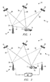
- FIGURE 1 illustrates several components used in a differential positioning system 10.
- the system includes components of a satellite-based or land-based positioning system 12 and components of a mobile communications network 14.
- Differential positioning system 10 provides accurate and immediate position information to vehicle 16 equipped with a mobile unit 17.
- Positioning system 12 is illustrated as a satellite-based radio navigation system, such as the NAVSTAR positioning system (GPS).
- GPS NAVSTAR positioning system
- the description uses the NAVSTAR GPS as a representative positioning system 12, but any land-based or satellite-based system may be used.
- positioning system 12 may be a land-based LORAN-C, a space-based GLONASS, or any other appropriate positioning technology.
- positioning system 12 comprises a plurality of space-based or land-based transmitters that emit position signals.
- the NAVSTAR GPS consists of a number of satellites in approximately twelve hour, inclined orbits of the earth, each satellite transmitting position signals.
- the GPS concept of operation is based upon satellite ranging. With position signals from three satellites, a GPS receiver can make an accurate calculation of its position in three dimensions. To make a valid position fix, the GPS receiver measures the propagation times of position signals from the satellites to a very high accuracy. This is accomplished by synchronizing the transmission of position signals to an atomic clock. However, to reduce costs and complexity, the GPS receiver may not maintain such an accurate clock, which introduces a clock bias (C B ) between the satellite clock and the GPS receiver clock. By measuring the apparent satellite signal propagation times from four satellites rather than three, the redundancy can be used to solve C B . The signal propagation times correspond to ranges of the GPS receiver from the satellites, related by the speed of light. Prior to correction for the clock bias C B , the apparent ranges of the satellites are all in error by a fixed amount and are called pseudoranges.
- the precise positioning service which is reserved for military use provides accuracy to within twenty-one meters (2drms).
- the statistical term "2drms” refers to a value that falls within two standard deviations (using the root-mean-squared method) of the sampled performance data mean. Therefore, a stated accuracy of twenty-one meters (2drms) means that the position error has an error of less than twenty-one meters approximately ninety-five percent of the time.
- the standard positioning service which is available for general use provides accuracy to within thirty meters (2drms).
- SPS standard positioning service
- This process called selective availability, degrades the accuracy of SPS position fixes to within one hundred meters (2drms).
- the SPS may be degraded in a number of ways, for example, by providing slightly inaccurate satellite orbital data to the receivers or by dithering the ranging information. Certain applications require better accuracy than provided by degraded SPS, SPS, or even PPS.
- Differential GPS technology may provide location accuracies to within three meters (2drms). Such accuracies allow, for example, accurate positioning of a delivery truck on a street map or precise locating for an in-vehicle navigation system.
- the precision of the GPS system is improved by broadcasting differential correction data to a GPS receiver.
- a typical DGPS positioning system such as the one implemented by the U.S. Coast Guard, uses known position coordinates of a reference station to compute corrections to GPS parameters, error sources, and resultant positions. This correction data is transmitted to GPS receivers to refine received position signals or computed position.
- Differential positioning system 10 in FIGURE 1 implements the DGPS concept using positioning system 12 integrated with mobile communications network 14 to accurately determine the location of vehicle 16.
- Differential positioning system 10 utilizes components of mobile communications network 14 as reference stations that provide correction data to vehicle 16 over an existing communications link, such as the control channel, overhead message stream, or paging channel of a cellular telephone network.
- Mobile communications network 14 may be a cellular telephone network, specialized mobile radio (SMR), enhanced specialized mobile radio (ESMR), a personal communications service (PCS), a satellite-based or land-based paging system, a citizen's band (CB), a dedicated radio system, such as those used by police and firefighters, or any other appropriate mobile communications technology.
- Differential positioning system 10 is described with reference to location of vehicle 16.
- the present invention contemplates location of all types of vehicles, including cars, trucks, airplanes, boats, barges, rail cars, truck trailers, or any other movable object that is desirable to locate or track.
- differential positioning system 10 can also be used to accurately locate a person carrying a portable or hand-held mobile unit 17.
- Potential applications of this technology may include delivery service dispatch, less-than-full-load (LTL) trucking applications, in-vehicle navigation systems, surveying applications, collision avoidance, emergency location using mobile 911 services, or any other application requiring accurate positioning information of a vehicle, object, or person.
- LTL less-than-full-load
- Differential positioning system 10 provides a more accurate position fix than currently available navigation services, and may provide these fixes near instantaneously or "on the fly.” In some applications, low frequency and low accuracy updates are sufficient, but other applications may need better accuracy and higher frequency updates in near real-time.
- a delivery truck may require accurate, high frequency position fixes for in-vehicle navigation to locate a specific delivery address or to provide real-time directions to the driver.
- Differential positioning system 10 may provide these high frequency updates without relying on off-vehicle computations prevalent in previous DGPS implementations.
- the same delivery truck may send lower frequency position reports to a remote location. These position reports may be sent at fixed time intervals, on-demand, or as a result of a predetermined reporting event.
- Differential positioning system 10 may provide both low and high frequency position fixes and reports in such a hybrid navigation and position reporting system.
- Satellite-based positioning system 12 is a navigation system using NAVSTAR GPS, GLONASS, or other satellite-based or land-based radio navigation system to provide ranging data to mobile unit 17.
- Satellites 18, 20, 22 maintain accurate and synchronized time and simultaneously transmit position signals that contain satellite specific and system information required by mobile unit 17 to generate position fixes.
- the position signals transmitted by satellites 18, 20, 22 may include high precision clock and ephemeris data for a particular satellite, low precision clock and ephemeris (called "almanac”) data for every satellite in the constellation, health and configuration status for all satellites, user text messages, and parameters describing the offset between GPS system time and UTC.
- Mobile unit 17 receives position signals over message data streams 26, 28, 30 from satellites 18, 20, 22, respectively. Additional satellites (not shown) may also communicate message data streams to mobile unit 17. Typically, mobile unit 17 receives at least four satellite message data streams to solve for position information independent of inherent clock bias (C B ) between positioning system 12 and mobile unit 17.
- C B inherent clock bias
- the NAVSTAR GPS system has twenty-one active satellites at 11,000 mile orbits of fifty-five degrees inclination with the equator. In normal conditions, mobile unit 17 may receive position signals from seven satellites.
- mobile unit 17 may determine its position using accurate satellite position information transmitted by satellites 18, 20, 22 and pseudorange data represented by the time of arrival of message data streams 26, 28, 30 to mobile unit 17. Using SPS this position fix may be accurate to within 30 meters (2drms) or 100 meters (2drms) when selective availability degradation is activated. If mobile unit 17 is allowed to operate using PPS, then the position fix may be accurate to within 21 meters (2drms).
- satellites 18, 20, 22 also transmit message data streams 32, 34, 36, respectively, to a reference positioning receiver 38 on or in proximity to a transmitter site 40 of mobile communications network 14.
- Reference positioning receiver 38 performs similar calculations to determine a position fix from position signals received from satellites 18, 20, 22.
- Reference positioning receiver 38 compares the computed position fix to known position coordinates and generates correction data for transmission over correction data stream 44 to mobile unit 17 for further refinements of position fix provided by mobile positioning receiver 24 (FIGURE 4).
- the known position coordinates of transmitter site 40 may be determined by traditional surveying techniques.
- reference positioning receiver 38 may perform position fixes over a statistically significant period of time to determine the known position coordinates. Filtering or averaging position fixes by reference positioning receiver 38 over time removes or substantially reduces the effect of selective availability degradation and may provide a more accurate position determination than uncorrupted SPS or even PPS.
- correction data generated by reference positioning receiver 38 is a position correction which is applied to the position fix of mobile positioning receiver 24 (FIGURE 4) of mobile unit 17 to achieve a more accurate position fix.
- the position correction may be in latitude/longitude, compass direction and distance, or any other appropriate coordinate system.
- this technique provides accurate correction data when mobile unit 17 and reference positioning receiver 38 are located in a satellite common view area of approximately thirty square miles. In the satellite common view area all receivers operating in positioning system 12 receive approximately the same pseudorange errors assuming they are all listening to the same group of satellites 18, 20, 22.
- This correction method places less correction data in correction data stream 44 than other methods, but the validity of those correction terms decreases rapidly as the distance between mobile unit 17 and reference positioning receiver 38 increases.
- the usefulness of this correction method is impaired when mobile unit 17 and reference positioning receiver 38 compute their position fixes using position signals from different satellites. Furthermore, this method requires that both mobile unit 17 and reference positioning receiver 38 compute a navigation solution.
- reference positioning receiver 38 computes pseudorange corrections (PRCs) to each satellite 18, 20, 22, which are then transmitted over correction data stream 44 to mobile unit 17 to refine its navigation solution.
- the PRCs for satellites 18, 20, 22 in view of reference positioning receiver 38 are the difference between the pseudorange and the computed range to each satellite 18, 20, 22 based on the known position coordinates of reference positioning receiver 38.
- Each PRC message includes an identification of the satellite 18, 20, 22 and a linear measure of the PRC.
- this method may include more transmission of data, it may result in a more accurate position fix.
- such a scheme provides additional flexibility to allow mobile unit 17 to use navigation data from any of the satellites that reference positioning receiver 38 has furnished PRCs.
- PCs position corrections
- Each satellite 18, 20, 22 sends an identifier in its respective message data stream.
- Both mobile unit 17 and reference positioning receiver 38 may use these identifiers to generate satellite group IDs (SGIDs) that identify the specific combination of satellites used for a position fix.
- Reference receiver 38 may generate the position correction for fifteen combinations (four satellites chosen from a total of six), and tag the position corrections with the appropriate SGIDs.
- Mobile unit 17, having determined an SGID for its position fix may then choose the proper position correction identified by the same SGID to ensure that mobile unit 17 and reference positioning receiver 38 use the same combination of satellites.
- this scheme with the NAVSTAR GPS, there would be 10,626 unique SGIDs for satellite combinations of four out of twenty-four satellites in the planned constellation.
- a single pseudorange correction (PRC) message for a satellite in the satellite common view area may include a satellite ID, the range correction in a selected precision, and other associated portions of the message, such as a header, delimiter, and checksum.
- PRC pseudorange correction
- a typical PRC message for six satellites described in the Motorola GPS Technical Reference Manual (October 1993) is fifty-two bytes long, including the header, delimiter, and checksum.
- a typical position correction message may include a four byte SGID (1 through 10,626), a one byte latitude correction, and a one byte longitude correction.
- a multiple position correction message for fifteen satellite combinations may total 90 bytes of correction data. Appropriate header, delimiter and checksum bytes consistent with the communication protocol of mobile communications network 14 may be added.
- the precision of pseudorange or position corrections depends on the anticipated range of error and the number of bytes allocated to the correction data. For example, one byte of eight bits may provide correction in the range of +/- 127 meters with one meter bit resolution. One byte may also provide correction in 0.25 meter bit resolution over a range of approximately +/- 32 meters.
- the precision, correction range, and byte allocation is a design choice that considers various factors, such as the available bandwidth in correction data stream 44, the accuracy of the unrefined position fix at mobile unit 17, the correction method employed, and the inherent inaccuracies of positioning system 12.
- Correction data stream 44 allows correction data to be transmitted from reference positioning receiver 38 to mobile unit 17.
- correction data stream 44 may be the control channel, paging channel, or overhead message stream currently implemented in cellular telephone technology.
- the control channel provides paging of incoming calls, hand-off instructions, and other features of the cellular telephone network, but may be modified by one skilled in the art to include transmission of correction data.
- Correction data stream 44 may also be implemented using any other communication link between transmitter site 40 and mobile communications device 42 (FIGURE 4) in mobile unit 17, whether or not the communication link requires seizing of a voice or data channel.
- correction data stream 44 There are several developing technologies that may provide a convenient implementation of correction data stream 44.
- cellular digital packet data (CDPD) technology allows integration of data and voice using the existing cellular telephone infrastructure.
- CDPD code division multiple access
- TDMA time division multiple access
- CDMA code division multiple access
- TDMA time division multiple access
- transmitter site 40 may either continuously broadcast correction data over correction data stream 44, such as in the control channel of the cellular telephone network, or only send correction data to mobile unit 17 when requested by a feature code request or by any other appropriate manner.
- Transmitter site 40 may send correction data to mobile unit 17 in one large packet or in several smaller packets interspersed with other data used for mobile communications.
- the correction data may be packaged in existing, but unused, bytes of the control channel or in a dedicated protocol.
- One possible implementation would place correction data in the extended protocol described in the EIA/TIA-533 mobile communications standard, which provides for bidirectional communication between transmitter site 40 and mobile unit 17.
- Reference positioning receiver 38 may continuously receive position updates and continuously compute correction data for transmission to mobile unit 17 over correction data stream 44. Alternatively, reference positioning receiver 38 may send correction data over correction data stream 44 at predetermined time intervals, at designated times when correction data stream 44 can accommodate the additional traffic, or when requested by mobile unit 17.
- Reference positioning receiver 38 may include an additional capability to ensure that correction data transmitted to mobile unit 17 by transmitter site 40 is current. This may be accomplished by including a time stamp in the correction data message to account for latency in the system. Using GPS technology as an example, satellites 18, 20, 22 in positioning system 12 provide position navigation data each second. Reference positioning receiver 38 may include an additional byte that indicates the delay in seconds of the correction data.
- the mobile unit 17 may save time-stamped position signals and later synchronize and correct the position signals with the time-stamped correction data received from transmitter site 40.
- the post-processing to refine past position fixes may be performed by mobile positioning receiver 24 (FIGURE 4) or other separate processor in mobile unit 17.
- Correction data stream 44 may be part of the control channel, part of a seized voice or data channel, or a separate channel requiring mobile unit 17 to re-tune to the correction data stream channel to receive valid corrections for the area.
- Mobile unit 17 may continuously monitor correction data stream 44 transmitted from transmitter site 40. Furthermore, mobile unit 17 may alternately tune between several correction data streams 44 from several transmitter sites 40 to determine the strongest signal, usually relating to the nearest transmitter site 40. This strongest channel select feature of mobile unit 17 assures that reference positioning receiver 38 and mobile unit 17 will be in close proximity and receive position signals from the same group or nearly the same group of satellites 18, 20, 22. For a typical transmitter site spacing in a cellular telephone network, the distance between mobile unit 17 and reference positioning receiver 38 may be less than five miles, well within the satellite common view area of the GPS system.
- Differential positioning system 10 contemplates placing reference positioning receiver 38 on each transmitter site 40 within mobile communications network 14.
- the satellite common view area may be much larger than the coverage area of a single transmitter site 40, thereby obviating the need to have reference positioning receivers 38 on each transmitter site 40.
- differential positioning system 10 may include reference positioning receivers 38 on selected transmitter sites 40 of mobile communications network 14.
- mobile unit 17, which may be capable of simultaneously monitoring correction data streams 44 from multiple transmitter sites 40 may still receive correction data from a transmitter site 40 that is currently not providing communication service to mobile unit 17.
- Selected transmitter sites 40 equipped with reference positioning receivers 38 may be spaced so that mobile unit 17 located anywhere in mobile communications network 14 can receive correction data of sufficient signal strength from one of the selected transmitter sites 40 equipped with reference positioning receivers 38.
- FIGURE 2 shows an alternative embodiment of differential positioning system 10 that places reference receivers 38 on selected transmitter sites 40 in mobile communications network 14.
- transmitter site 40 is associated with reference positioning receiver 38, which receives position signals in message data streams 32, 34, 36 from satellites 18, 20, 22, respectively.
- mobile unit 17 is located in an area serviced by transmitter site 46, which is not equipped with reference positioning receiver 38.
- mobile unit 17 is unable to receive correction data directly from transmitter site 40 due to the inability to monitor communications from transmitter sites 40 and 46, the distance from transmitter site 40, or other reasons.
- mobile unit 17 is close enough to reference positioning receiver 38 to receive navigation data from at least a subset of satellites 18, 20, 22 serving reference positioning receiver 38.
- reference positioning receiver 38 uses any of the correction methods described above with reference to FIGURE to refine a position fix derived from position signals received from satellites 18, 20, 22 over message data streams 26, 28, 30.
- Differential positioning system 10 reduces the number of reference positioning receivers 38 required by networking correction data through link 48 between transmitter sites 40, 46.
- Link 48 between transmitter sites 40, 46 may include microwave communications, bidirectional paging or control channels, direct land-line connections, switching stations such as MTSOs, or any other appropriate communications device to send correction data from transmitter site 40 to transmitter site 46.
- FIGURE 3 is a schematic representation of transmitter site 40 associated with reference positioning receiver 38.
- Reference positioning receiver 38 may be mounted directly on transmitter site 40 or on a separate structure or mounting.
- Reference positioning receiver 38 includes an antenna 50, receiver 51, controller 52, and memory 54. The following description relates to the operation of reference positioning receiver 38 with a GPS positioning system, however, the same concepts apply to other land-based and satellite-based positioning systems.
- Reference positioning receiver 38 receives position signals in message data streams 32, 34, 36 from satellites 18, 20, 22, respectively.
- the position signals include navigation data, such as ephemeris, almanac, and clock correction data.
- Ephemeris data includes detailed information about the specific satellite course over the next two hours
- the almanac data includes less detailed information about the complete satellite constellation for a longer period
- the clock correction data includes information to correct for clock errors.
- the satellite transmissions received by antenna 50 consist of a direct sequence spread spectrum signal containing the ephemeris, almanac, and clock correction data at a rate of fifty bits per second.
- a pseudorandom noise signal with a chip rate of 1.023 MHz that is unique to each satellite is used to spread the spectrum of the information which is then transmitted on a center frequency of 1575.42 MHz.
- Receiver 51 receives satellite position signals having a bandwidth of approximately 2 MHz and a signal-to-noise ratio of approximately -20 dB.
- the relative movement between satellites 18, 20, 22 and reference positioning receiver 38 causes an additional Doppler frequency offset from the GPS center frequency.
- receiver 51 must cancel or allow for the Doppler frequency offset and generate the proper coarse/acquisition code associated with each satellite 18, 20, 22 to despread the signal.
- receiver 51 may extract the ephemeris, almanac, and clock correction data and pass this information to controller 52.
- Controller 52 receives navigation data from at least three satellites and uses this information to determine a navigation solution based on well-known triangulation techniques.
- Controller 52 may use certain data stored in memory 54 to arrive at a navigation solution. Controller 52 may then compare the instantaneous navigation solution (X, Y, Z) to known position coordinates (X 0 , Y 0, Z 0 ) stored in memory 54 to generate position correction data in latitude/longitude, compass direction and distance, or other appropriate coordinate system.
- controller 52 may receive ephemeris, almanac, and clock correction data from satellites 18, 20, 22 and compute a pseudorange (R N ) for each satellite. Since the satellite signal contains information on the precise satellite orbits and controller 52 has known position coordinates (X 0 , Y 0 , Z 0 ) stored in memory 54, the true range to each satellite 18, 20, 22 can be calculated. By comparing the true range and the measured pseudorange, a pseudorange correction (PRC) for each satellite 18, 20, 22 may be computed and sent as correction data. As described above with reference to FIGURE 1, controller 52 may also provide position correction data based on navigation solutions using all possible combinations of satellites 18, 20, 22 currently in view of reference positioning receiver 38.
- PRC pseudorange correction
- Correction data in any of the various forms described above is sent by controller 52 to channel controller 56 of transmitter site 40 over communication link 58.
- Communication link 58 may be a direct wire connection, a radio communication link, a connection through a switched telephone system, or other appropriate communication link.
- channel controller 56 may send correction data to radio duplexer 60 for transmission over transmitter site antenna 62 to mobile unit 17.
- channel controller 56 may pass correction data through link 48 to transmitter site 46 currently serving mobile unit 17.
- TOA data generator 64 generates a TOA data message and sends this message to channel controller 56 for transmission to mobile unit 17 over transmitter site antenna 62.
- the TOA data message may include a precise time of transmission based on information maintained by clock 66.
- Clock 66 and TOA data generator 64 are shown as elements of transmitter site 40, but it should be understood that their functions may also be implemented in a central or distributed device accessible by transmitter sites 40, 46 of mobile communications network 14.
- FIGURE 4 is a schematic representation of a mobile unit 17 that includes mobile positioning receiver 24, mobile communications device 42, and other associated hardware and software, described below.
- Mobile positioning receiver 24 is similar in construction and function to reference positioning receiver 38 and includes an antenna 82, receiver 84, controller 86, and memory 88.
- mobile positioning receiver 24 receives position signals from satellites 18, 20, 22 over message data streams 26, 28, 30 at antenna 82.
- Receiver 84 processes these signals to extract ephemeris, almanac, and clock correction data.
- Controller 86 receives this information and computes a navigation solution or pseudorange measurements. These calculations performed by controller 86 may use data stored in memory 88.
- Mobile communications device 42 includes an antenna 90, transceiver 92, and hand set 94.
- mobile communications device 42 receives correction data at antenna 90 over correction data stream 44.
- the correction data may be transmitted directly from transmitter site 40 equipped with reference positioning receiver 38 as described with reference to FIGURE 1, or indirectly through link 48 and transmitter site 46 as described with reference to FIGURE 2.
- the correction data may be in a variety of forms, including single or multiple position corrections, or pseudorange corrections to each satellite.
- Correction data is then stripped from correction data stream 44 by transceiver 92.
- Correction data may be passed to processor 100 over link 95 or over any other appropriate path, such as through bus drivers 112 and modem or dual tone multifrequency (DTMF) coder/decoder 110.
- Hand set 94 provides traditional voice or data communication using mobile communications device 42.
- Processor 100 manages the communicating, locating, and reporting features of mobile unit 17.
- Processor 100 receives a navigation solution or pseudorange measurements from controller 86 and correction data from transceiver 92.
- memory 102 may contain programs, databases, and other information required by processor 100 to perform its functions.
- memory 102 may contain a table of known position coordinates of transmitter sites 40 for use in computing the position of mobile unit 17 in the alternative positioning system 200 described with reference to FIGURE 6.
- Memory 102 may be random access memory (RAM), read-only memory (ROM), CD-ROM, removable memory devices, or any other device that allows storage or retrieval of data.
- Processor 100 and controller 86, as well as memory 102 and memory 88, may be separate or integral components of mobile unit 17.
- controller 86 may include a port that directly receives correction data and allows mobile positioning receiver 24 to output a refined position fix.
- Mobile unit 17 contemplates any arrangement, processing capability, or task assignment between controller 86 and processor 100.
- processor 100 In operation, processor 100 generates a refined position fix for mobile unit 17 based on the navigation solution or pseudorange measurements from controller 86 and the correction data from transceiver 92. This refined position fix may be sent to output device 104 to generate a moving or static display of vehicle 16 on a map represented by map data stored in memory 102. Alternatively, output device 104 may produce audible information, such as directions or location updates, to the operator of vehicle 16.
- Processor 100 is also coupled to input device 106 that allows operation of mobile unit 17.
- Input device 106 may be a keypad or touch screen, as well as voice recognition software and hardware that can accept audible commands and information.
- output device 104 and input device 106 may include fixed or removable storage media, such as magnetic computer discs, CD-ROM, or other suitable media to both receive output and provide input to processor 100.
- Processor 100 may also generate data messages for transmission to a remote location using mobile communications device 42.
- the data messages may include the refined position fix of mobile unit 17, the time of reporting, or information input by the vehicle operator, as well as any other information collected by processor 100 from various sensors 108.
- sensors 108 may include various engine sensors, truck trailer sensors, security monitors, or other devices generating information on the status or condition of mobile unit 17, vehicle 16, or its operator.
- the generation and transmission of a data message may be based on elapsed time, movement of mobile unit 17, sensor readings, or any other piece of information that may necessitate reporting to a remote location.
- the data messages are sent from processor 100 through modem or DTMF coder/decoder 110 to bus drivers 112, and then to transceiver 92 for transmission over antenna 90 to a remote location, such as central host 120 (FIGURE 5). Data messages may also be sent directly to transceiver 92 over link 95.
- Mobile unit 17 may also include a clock 116 coupled to processor 100 that may be used to synchronize the navigation solutions or pseudorange measurements received from controller 86 with latent correction data received from transceiver 92.
- Clock 116 may also be used in alternative positioning system 200 described with reference to FIGURE 6. In operation, clock 116 provides accurate time to processor 100, and may receive clock correction updates from mobile positioning receiver 24 or through correction data from mobile communications device 42.
- Mobile unit 17 shown in FIGURE 4 may be packaged into one or more housings.
- Mobile unit 17 may be mounted to vehicle 16 or an object to be tracked.
- Mobile unit 17 may also be packaged as a portable, hand-held device that provides personal locating, communicating, and reporting functions.
- a portable, hand-held mobile unit 17 may be used by surveyors, rescue teams, individuals that may change forms of transportation, or any other application requiring portability of mobile unit 17.
- FIGURE 5 is a schematic representation of a central host 120.
- Central host 120 receives communications from mobile unit 17, such as reports generated by processor 100, through link 122.
- Link 122 may be one or a combination of dedicated telephone lines, switched telephone lines, microwave communications links, satellite-based communications links, or any other suitable communication link that allows mobile unit 17 to transmit data to or receive data from central host 120.
- a data message from mobile unit 17 enters central host 120 through a modem or DTMF coder/decoder 124 and passes to central controller 126. Coupled to central controller 126 is memory 128 and input/output device 130.
- Memory 128 may be RAM, ROM, CD-ROM, removable memory devices, or any other device that allows storage or retrieval of data.
- Input/output 130 includes any variety of output devices, such as a display, a speaker to provide audible information, removable storage media, or any other appropriate output device.
- Input/output device 130 may also include a variety of input devices, such as a keyboard, mouse, touch screen, removable storage media, or any other appropriate input device.
- Central controller 126 receives data messages from mobile unit 17 and processes this information to locate, track, dispatch, and communicate with mobile unit 17. For example, central controller 126 can maintain a database in memory 128 of all mobile units 17 with their current location, status, and relevant sensor readings. This database can also be used to initiate communication with mobile unit 17. Furthermore, central controller 126 may perform a call delivery function that routes incoming calls to mobile unit 17 through link 122. This aspect of call delivery is fully described in Application Serial No. 08/095,166, entitled “Method and Apparatus for a National-Wide Cellular Telephone Network” filed July 20, 1993, and Application Serial No. 08/175,256 entitled “Data Messaging in a Communications Network” filed December 28, 1993, both applications commonly owned by the assignee of the present application, and both applications hereby incorporated by reference.
- FIGURE 6 illustrates an alternative positioning system 200 that utilizes equipment of the existing mobile communications network 14 to locate vehicle 16 equipped with a modified mobile unit 17.
- Mobile unit 17 communicates with transmitter sites 202, 204, 206 over communications links 208, 210, 212, respectively.
- Communication links 208, 210, 212 may be the control channel, overhead message stream, or paging channel of a cellular telephone network, a portion or all of a seized voice or data channel, or a dedicated channel.
- Transmitter sites 202, 204, 206 may be coupled to a network in a variety of ways. For example, transmitter site 202 is coupled to transmitter site 204 over land-line connections through MTSO 214. Transmitter site 202 is coupled to transmitter site 206 over a microwave or other radio link 216. Transmitter site 204 is coupled to transmitter site 206 over a direct or dedicated connection 218.
- Positioning system 200 operates in a similar fashion to an aspect of differential positioning system 10 described with reference to FIGUREs 1 and 2, but does not rely on a positioning system 12 to transmit navigation data. Instead, transmitter sites 202, 204, 206 transmit time-of-arrival (TOA) data over respective communications links 208, 210, 212. Mobile unit 17 receives TOA data and computes the position of mobile unit 17 using the TOA data and known position coordinates of transmitter sites 202, 204, 206.
- TOA time-of-arrival
- the TOA data from transmitter sites 202, 204, 206 may be transmitted in a variety of ways.
- a network clock 220 synchronizes the instantaneous transmission of TOA data from transmitter sites 202, 204, 206.
- the time of reception at mobile unit 17 provides pseudorange measurements to transmitter sites 202, 204, 206.
- a fourth transmitter site allows the position of mobile unit 17 to be computed without regard for a clock bias (C B ) between network clock 220 and clock 116 (FIGURE 4) maintained on mobile unit 17.
- C B clock bias
- transmitter sites 202, 204, 206 transmit TOA data at different times, but include the time of transmission in the message to mobile unit 17. Assuming cellular transmitter sites 202, 204, 206 maintain synchronized time through network clock 220, mobile unit 17 can generate pseudorange measurements by comparing the message time of arrival to the time of transmission.
- Transmitter sites 202, 204, 206 and mobile unit 17 may have different configurations when operating in positioning system 200.
- transmitter site 40 does not need an associated reference positioning receiver 38 to provide location information in positioning system 200.
- Transmitter site 40 does include TOA data generator 64 and clock 66 to generate the TOA data for transmission to mobile unit 17.
- mobile unit 17 does not require mobile positioning receiver 24 for operation within positioning system 200.
- TOA data is received by transceiver 92 and sent to processor 100, which uses the TOA data to compute pseudoranges to cellular transmitter sites 202, 204, 206.
- processor 100 may then compute a position fix of mobile unit 17 using the pseudoranges and known position coordinates of transmitter sites 202, 204, 206 stored in memory 102.
Landscapes
- Engineering & Computer Science (AREA)
- Radar, Positioning & Navigation (AREA)
- Remote Sensing (AREA)
- Computer Networks & Wireless Communication (AREA)
- Physics & Mathematics (AREA)
- General Physics & Mathematics (AREA)
- Signal Processing (AREA)
- Position Fixing By Use Of Radio Waves (AREA)
- Mobile Radio Communication Systems (AREA)
- Radar Systems Or Details Thereof (AREA)
Abstract
Description
Claims (27)
- A locating system using a cellular telephone network, the locating system having a reference positioning receiver (38) located at a transmitter site (40) of the cellular telephone network and a mobile unit (17) in communication with the cellular telephone network, the reference positioning receiver (38) having known position coordinates and the transmitter site (40) of the cellular telephone network being coupled to the reference positioning receiver (38), characterized in that:the reference positioning receiver (38) is operable to receive first position signals from a positioning system (12), the reference positioning receiver (38) further operable to generate correction data in response to the first position signals and the known position coordinates;the transmitter site (40) of the cellular telephone network is operable to receive correction data generated by the reference positioning receiver (38), the transmitter site (40) operable to transmit the correction data generated by the reference positioning receiver (38); andthe mobile unit (17) is operable to communicate with the positioning system (12), the mobile unit (17) operable to receive correction data transmitted by the transmitter site (40), the mobile unit (17) further operable to receive second position signals from the positioning system (12) and to determine the location of the mobile unit (17) in response to the second position signals and the correction data.
- The system of Claim 1, characterized in that the transmitter site (40) transmits the correction data in a control channel.
- The system of Claim 1, characterized in that the mobile unit (17) further comprises:a mobile communications device (42) in communication with the cellular telephone network, the mobile communications device operable to receive correction data transmitted by the transmitter site (40);a mobile positioning receiver (24) coupled to the mobile communications device (42), the mobile positioning receiver operable to receive second position signals from the positioning system (12); anda processor (100) coupled to the mobile communications device (42) and the mobile positioning receiver (24), the processor (100) operable to determine the location of the mobile unit (17) in response to the second position signals received from the mobile positioning receiver (24) and the correction data received from the mobile communications device (42).
- A locating system using a mobile communications network, the locating system having a reference positioning receiver (38) located at a first transmitter site (40) of the mobile communications network, the reference positioning receiver (38) having known position coordinates and the first transmitter site (40) of the mobile communications network being coupled to the reference positioning receiver (38), a second transmitter site (46) of the mobile communications network coupled to the first transmitter site (40), and a mobile unit (17) in communication with the mobile communications network, characterized in that:the reference positioning receiver (38) is operable to receive first position signals from a positioning system (12), the reference positioning receiver (38) further operable to generate correction data in response to the first position signals and the known position coordinates;the first transmitter site (40) is operable to receive correction data generated by the reference positioning receiver (38);the second transmitter site (46) is operable to transmit correction data received from the first transmitter site (40); andthe mobile unit (17) is operable to communicate with the second transmitter site (46) and the positioning system (12), the mobile unit (17) operable to receive correction data transmitted by the second transmitter site (46), the mobile unit (17) further operable to receive second position signals from the positioning system (12) and to determine the location of the mobile unit (17) in response to the second position signals and the correction data.
- The system of Claim 4, characterized in that the system further comprises a communications link coupled to the first and second transmitter sites, the communications link operable to receive correction data from the first transmitter site (40) and to transmit the correction data to the second transmitter site (46).
- The system of Claim 4, characterized in that the second transmitter site (46) transmits the correction data in a control channel.
- The system of Claim 4, characterized in that the mobile unit (17) further comprises:a mobile communications device (42) in communication with the cellular telephone network, the mobile communications device operable to receive correction data transmitted by the second transmitter site (46);a mobile positioning receiver (24) coupled to the mobile communications device (42), the mobile positioning receiver operable to receive second position signals from the positioning system (12); anda processor (100) coupled to the mobile communications device (42) and the mobile positioning receiver (24), the processor operable to determine the location of the mobile unit (17) in response to the second position signals received from the mobile positioning receiver (24) and the correction data received from the mobile communications device (42).
- The system of Claim 1 or Claim 4, characterized in that the known position coordinates of the reference positioning receiver (38) are based on data received by the reference positioning receiver (38) from the positioning system (12) over a statistically significant period of time.
- The system of Claim 1 or Claim 4, characterized in that the correction data comprises a position correction representing a comparison between a position fix based on the first position signals and the known position coordinates of the reference positioning receiver (38).
- The system of Claim 1 or Claim 4, characterized in that:the first position signals comprise time-of-arrival data received by the reference positioning receiver (38) from a plurality of satellites (18, 20, 22); andthe correction data comprises performance corrections for each satellite.
- The system of Claim 1 or Claim 4, characterized in that the system further comprises:a memory (102) coupled to the mobile unit (17), the memory operable to store map data; anda display (104) coupled to the mobile unit (17), the display operable to display the location of the mobile unit and the map data.
- The system of Claim 1 or Claim 4, characterized in that the system further comprises a central controller (126) coupled to the mobile unit (17), the central controller operable to receive the location of the mobile unit.
- The system of Claim 1 or Claim 4, characterized in that the mobile unit (17) is mounted on a vehicle (16).
- The system of Claim I or Claim 4, characterized in that the mobile unit (17) is housed in a portable, hand-held housing (94).
- An apparatus for locating a vehicle (16) within the service area of a cellular telephone network, the apparatus having a mobile communications device (42) on the vehicle and coupled to a transmitter site (40) of the cellular telephone network, characterized by:a positioning receiver (24) on the vehicle (16) and operable to receive first position signals from a positioning system (12);the mobile unit communications device (42) operable to receive from the transmitter site (40) correction data generated at the transmitter site; anda processor (100) on the vehicle (16) and coupled to the positioning receiver (24) and the mobile communications device (42), the processor operable to determine the location of the vehicle in response to the first position signals and the correction data.
- The apparatus of Claim 15, characterized in that the mobile communications device (42) receives the correction data in a control channel transmitted by the transmitter site (40) of the cellular telephone network.
- The apparatus of Claim 15, characterized in that the apparatus further comprises:a memory (102) coupled to the processor (100), the memory operable to store map data; anda display (104) coupled to the processor (102), the display operable to display the location of the vehicle (16) and the map data.
- The apparatus of Claim 15, characterized in that the apparatus further comprises a central controller (126) coupled to the mobile communications device (42), the central controller operable to receive the location of the vehicle (16).
- The apparatus of Claim 15, characterized in that the correction data comprises a position correction.
- The apparatus of Claim 15, characterized in that the correction data comprises pseudorange corrections from a plurality of satellites (18,20,22) in the positioning system (12).
- A method for locating a mobile unit (17) within the service area of a cellular telephone network, characterized by:receiving first position signals from a positioning system (12) at a reference positioning receiver (38) having known position coordinates, the reference positioning receiver (38) located at a transmitter site (40) of a cellular telephone network;generating, at the transmitter site (40), correction data in response to the first position signals and the known position coordinates;receiving, from the transmitter site (40), correction data at a cellular transceiver (92) in the mobile unit (17);receiving second position signals from a positioning system (12) at a mobile positioning receiver (24) in the mobile unit (17); anddetermining the location of the mobile unit (17) in response to the second position signals and the correction data.
- The method of Claim 21, characterized in that the correction data is received at the cellular transceiver (92) in a control channel.
- The method of Claim 21, characterized in that the correction data comprises a position correction representing a comparison between a position fix based on the first position signals and the known position coordinates of the reference positioning receiver (38).
- The method of Claims 21,22 or 23, characterized in that:the positioning system comprises a plurality of satellites (18,20,22); andthe correction data comprises pseudorange corrections for each satellite.
- The method of any of Claims 21 to 24, characterized in that the method further comprises displaying the location of the mobile unit on a map.
- The method of any of Claims 21 to 25, characterized in that the method further comprises receiving the location of the mobile unit at a remote location.
- The method of any of Claims 21 to 26, characterized in that the positioning system is GPS.
Applications Claiming Priority (3)
| Application Number | Priority Date | Filing Date | Title |
|---|---|---|---|
| US08/340,755 US5913170A (en) | 1994-11-16 | 1994-11-16 | Locating system and method using a mobile communications network |
| US340755 | 1994-11-16 | ||
| PCT/US1995/014862 WO1996015636A1 (en) | 1994-11-16 | 1995-11-14 | Locating system and method using a mobile communications network |
Publications (3)
| Publication Number | Publication Date |
|---|---|
| EP0811296A1 EP0811296A1 (en) | 1997-12-10 |
| EP0811296A4 EP0811296A4 (en) | 2000-07-05 |
| EP0811296B1 true EP0811296B1 (en) | 2002-09-25 |
Family
ID=23334798
Family Applications (1)
| Application Number | Title | Priority Date | Filing Date |
|---|---|---|---|
| EP95939979A Expired - Lifetime EP0811296B1 (en) | 1994-11-16 | 1995-11-14 | Locating system and method using a mobile communications network |
Country Status (9)
| Country | Link |
|---|---|
| US (2) | US5913170A (en) |
| EP (1) | EP0811296B1 (en) |
| JP (1) | JPH10509000A (en) |
| AT (1) | ATE225114T1 (en) |
| AU (1) | AU4160796A (en) |
| CA (1) | CA2205462A1 (en) |
| DE (1) | DE69528382D1 (en) |
| MX (1) | MX9703646A (en) |
| WO (1) | WO1996015636A1 (en) |
Cited By (9)
| Publication number | Priority date | Publication date | Assignee | Title |
|---|---|---|---|---|
| US7714778B2 (en) | 1997-08-20 | 2010-05-11 | Tracbeam Llc | Wireless location gateway and applications therefor |
| US7764231B1 (en) | 1996-09-09 | 2010-07-27 | Tracbeam Llc | Wireless location using multiple mobile station location techniques |
| US7812766B2 (en) | 1996-09-09 | 2010-10-12 | Tracbeam Llc | Locating a mobile station and applications therefor |
| US7903029B2 (en) | 1996-09-09 | 2011-03-08 | Tracbeam Llc | Wireless location routing applications and architecture therefor |
| US8082096B2 (en) | 2001-05-22 | 2011-12-20 | Tracbeam Llc | Wireless location routing applications and architecture therefor |
| US8135413B2 (en) | 1998-11-24 | 2012-03-13 | Tracbeam Llc | Platform and applications for wireless location and other complex services |
| US8694025B2 (en) | 1999-09-24 | 2014-04-08 | Dennis Dupray | Geographically constrained network services |
| US9134398B2 (en) | 1996-09-09 | 2015-09-15 | Tracbeam Llc | Wireless location using network centric location estimators |
| US9538493B2 (en) | 2010-08-23 | 2017-01-03 | Finetrak, Llc | Locating a mobile station and applications therefor |
Families Citing this family (235)
| Publication number | Priority date | Publication date | Assignee | Title |
|---|---|---|---|---|
| US5539810A (en) | 1992-01-27 | 1996-07-23 | Highwaymaster Communications, Inc. | Data messaging in a communications network |
| US6295449B1 (en) * | 1992-01-27 | 2001-09-25 | @Track Communications, Inc. | Data messaging in a communications network using a feature request |
| US5884214A (en) | 1996-09-06 | 1999-03-16 | Snaptrack, Inc. | GPS receiver and method for processing GPS signals |
| US6133871A (en) * | 1995-10-09 | 2000-10-17 | Snaptrack, Inc. | GPS receiver having power management |
| US6131067A (en) * | 1995-10-09 | 2000-10-10 | Snaptrack, Inc. | Client-server based remote locator device |
| US6208290B1 (en) * | 1996-03-08 | 2001-03-27 | Snaptrack, Inc. | GPS receiver utilizing a communication link |
| US5841396A (en) * | 1996-03-08 | 1998-11-24 | Snaptrack, Inc. | GPS receiver utilizing a communication link |
| US8090598B2 (en) | 1996-01-29 | 2012-01-03 | Progressive Casualty Insurance Company | Monitoring system for determining and communicating a cost of insurance |
| US8140358B1 (en) | 1996-01-29 | 2012-03-20 | Progressive Casualty Insurance Company | Vehicle monitoring system |
| US5945944A (en) * | 1996-03-08 | 1999-08-31 | Snaptrack, Inc. | Method and apparatus for determining time for GPS receivers |
| US5793630A (en) * | 1996-06-14 | 1998-08-11 | Xerox Corporation | High precision spatially defined data transfer system |
| US6249252B1 (en) | 1996-09-09 | 2001-06-19 | Tracbeam Llc | Wireless location using multiple location estimators |
| FR2755331B1 (en) * | 1996-10-29 | 1998-11-27 | Ertp Etudes Et Realisations Te | RADIO NETWORK WITH GEOGRAPHICAL RESOURCES |
| US5983109A (en) | 1997-02-03 | 1999-11-09 | Northern Telecom Limited | Method and apparatus for using advanced positioning systems in cellular communications networks |
| FR2762168B1 (en) * | 1997-04-10 | 1999-05-07 | Alsthom Cge Alcatel | MOBILE STATION INTEGRATING RADIOCOMMUNICATION AND LOCATION FUNCTIONS, AND CORRESPONDING METHOD FOR RECEIVING LOCATION SIGNALS BY A MOBILE STATION |
| AU753409B2 (en) * | 1997-05-19 | 2002-10-17 | Airbiquity Inc. | System and method to communicate time stamped, 3-axis geo-position data within telecommunication networks |
| US6493338B1 (en) | 1997-05-19 | 2002-12-10 | Airbiquity Inc. | Multichannel in-band signaling for data communications over digital wireless telecommunications networks |
| US6690681B1 (en) * | 1997-05-19 | 2004-02-10 | Airbiquity Inc. | In-band signaling for data communications over digital wireless telecommunications network |
| US6167274A (en) * | 1997-06-03 | 2000-12-26 | At&T Wireless Svcs. Inc. | Method for locating a mobile station |
| US6101178A (en) * | 1997-07-10 | 2000-08-08 | Ksi Inc. | Pseudolite-augmented GPS for locating wireless telephones |
| US6560461B1 (en) | 1997-08-04 | 2003-05-06 | Mundi Fomukong | Authorized location reporting paging system |
| US6636733B1 (en) | 1997-09-19 | 2003-10-21 | Thompson Trust | Wireless messaging method |
| US6070078A (en) * | 1997-10-15 | 2000-05-30 | Ericsson Inc. | Reduced global positioning system receiver code shift search space for a cellular telephone system |
| US6081229A (en) * | 1998-03-17 | 2000-06-27 | Qualcomm Incorporated | System and method for determining the position of a wireless CDMA transceiver |
| US6061018A (en) | 1998-05-05 | 2000-05-09 | Snaptrack, Inc. | Method and system for using altitude information in a satellite positioning system |
| US6816710B2 (en) * | 1998-05-06 | 2004-11-09 | Snaptrack, Inc. | Method and apparatus for signal processing in a satellite positioning system |
| US6249245B1 (en) * | 1998-05-14 | 2001-06-19 | Nortel Networks Limited | GPS and cellular system interworking |
| US6711379B1 (en) * | 1998-05-28 | 2004-03-23 | Kabushiki Kaisha Toshiba | Digital broadcasting system and terminal therefor |
| US6636740B1 (en) * | 1998-06-16 | 2003-10-21 | Ericsson Inc. | Apparatus and methods for position computation based on broadcast initialization data |
| DE19826737A1 (en) * | 1998-06-16 | 1999-12-23 | Jens Rainer Schuessler | Collision warning method for aircraft |
| US6539080B1 (en) | 1998-07-14 | 2003-03-25 | Ameritech Corporation | Method and system for providing quick directions |
| US20010012771A1 (en) * | 1998-08-07 | 2001-08-09 | Everardo Ruiz | A system of correcting error in received gps signals of a mobile station in a cdma system by transmitting error references to the mobile station |
| US6415154B1 (en) | 1998-10-06 | 2002-07-02 | Ericsson Inc. | Method and apparatus for communicating auxilliary information and location information between a cellular telephone network and a global positioning system receiver for reducing code shift search time of the receiver |
| KR20010080715A (en) * | 1998-12-08 | 2001-08-22 | 도날드 디. 먼둘 | Provisioning of gps assistance data in a wcdma network |
| US7215967B1 (en) * | 1998-12-22 | 2007-05-08 | Telefonaktiebolaget Lm Ericsson (Publ) | System and method for fast cold start of a GPS receiver in a telecommunications environment |
| DE60043259D1 (en) * | 1999-03-17 | 2009-12-17 | Komatsu Mfg Co Ltd | COMMUNICATION ARRANGEMENT OF A MOBILE UNIT |
| US6829534B2 (en) | 1999-04-23 | 2004-12-07 | Global Locate, Inc. | Method and apparatus for performing timing synchronization |
| US6411892B1 (en) * | 2000-07-13 | 2002-06-25 | Global Locate, Inc. | Method and apparatus for locating mobile receivers using a wide area reference network for propagating ephemeris |
| US7053824B2 (en) | 2001-11-06 | 2006-05-30 | Global Locate, Inc. | Method and apparatus for receiving a global positioning system signal using a cellular acquisition signal |
| US6453237B1 (en) * | 1999-04-23 | 2002-09-17 | Global Locate, Inc. | Method and apparatus for locating and providing services to mobile devices |
| GB9915841D0 (en) * | 1999-07-06 | 1999-09-08 | Nokia Telecommunications Oy | Location of a station |
| JP4697500B2 (en) * | 1999-08-09 | 2011-06-08 | ソニー株式会社 | TRANSMISSION DEVICE, TRANSMISSION METHOD, RECEPTION DEVICE, RECEPTION METHOD, AND RECORDING MEDIUM |
| US6323803B1 (en) | 1999-08-10 | 2001-11-27 | Ericsson Inc. | System and method for incremental broadcast of GPS navigation data in a cellular network |
| US6285320B1 (en) | 1999-09-03 | 2001-09-04 | Sikorsky Aircraft Corporation | Apparatus and method for mapping surfaces of an object |
| US6429808B1 (en) * | 1999-11-12 | 2002-08-06 | Motorola, Inc. | Method and apparatus for assisted GPS integrity maintenance |
| GB9928416D0 (en) * | 1999-12-01 | 2000-01-26 | Nokia Networks Oy | A telecommunications system |
| US6564064B1 (en) * | 1999-12-01 | 2003-05-13 | Trimble Navigation Limited | Cellular telephone using pseudolites for determining location |
| US6356841B1 (en) | 1999-12-29 | 2002-03-12 | Bellsouth Intellectual Property Corporation | G.P.S. management system |
| US6510381B2 (en) | 2000-02-11 | 2003-01-21 | Thomas L. Grounds | Vehicle mounted device and a method for transmitting vehicle position data to a network-based server |
| SE518206C2 (en) * | 2000-02-23 | 2002-09-10 | Telia Ab | Device and method of position determination by differential GPS |
| US7024190B1 (en) * | 2000-03-02 | 2006-04-04 | Orbcomm Llc | Method of random access communication using subbanding and variable length messages |
| ATE470874T1 (en) | 2000-03-20 | 2010-06-15 | Qualcomm Inc | METHOD AND DEVICE FOR USING AUXILIARY DATA AS PART OF A SATELLITE POSITION DETERMINATION SYSTEM |
| GB2360588B (en) * | 2000-03-23 | 2004-04-07 | Yeoman Group Plc | Navigation system |
| US6609005B1 (en) * | 2000-03-28 | 2003-08-19 | Leap Wireless International, Inc. | System and method for displaying the location of a wireless communications device wiring a universal resource locator |
| US6587692B1 (en) * | 2000-03-30 | 2003-07-01 | Lucent Technologies Inc. | Location determination using weighted ridge regression |
| US6763241B2 (en) * | 2000-04-14 | 2004-07-13 | Varitek Industries, Inc. | Data communications synchronization using GPS receiver |
| US20020005801A1 (en) * | 2000-05-03 | 2002-01-17 | Sergey Lyusin | Low signal-to-noise ratio positioning system |
| WO2001084745A1 (en) * | 2000-05-03 | 2001-11-08 | Magellan Corporation | Method and apparatus for interference reduction |
| US6456854B1 (en) | 2000-05-08 | 2002-09-24 | Leap Wireless International | System and method for locating and tracking mobile telephone devices via the internet |
| GB0011797D0 (en) * | 2000-05-16 | 2000-07-05 | Yeoman Group Plc | Improved vehicle routeing |
| US20020053985A1 (en) * | 2000-05-16 | 2002-05-09 | Nesbitt Bryce C. | Method and system for providing corrected time dependent data across a wireless network |
| GB0012143D0 (en) * | 2000-05-20 | 2000-07-12 | Hewlett Packard Co | Obtaining location updates about mobile entity for use in a location-sensitive application |
| US6532416B1 (en) * | 2000-05-23 | 2003-03-11 | Siemens Aktiengesellschaft | Apparatus, method and system for a wireless communication and local positioning system in an automated, industrial and/or manufacturing environment |
| GB0012445D0 (en) * | 2000-05-24 | 2000-07-12 | Hewlett Packard Co | Location-based equipment control |
| US9875492B2 (en) | 2001-05-22 | 2018-01-23 | Dennis J. Dupray | Real estate transaction system |
| US10641861B2 (en) | 2000-06-02 | 2020-05-05 | Dennis J. Dupray | Services and applications for a communications network |
| US10684350B2 (en) | 2000-06-02 | 2020-06-16 | Tracbeam Llc | Services and applications for a communications network |
| US8060389B2 (en) | 2000-06-07 | 2011-11-15 | Apple Inc. | System and method for anonymous location based services |
| US8489669B2 (en) | 2000-06-07 | 2013-07-16 | Apple Inc. | Mobile data processing system moving interest radius |
| US6456234B1 (en) | 2000-06-07 | 2002-09-24 | William J. Johnson | System and method for proactive content delivery by situation location |
| US7126527B1 (en) | 2000-06-23 | 2006-10-24 | Intel Corporation | Method and apparatus for mobile device location via a network based local area augmentation system |
| FI108372B (en) * | 2000-06-30 | 2002-01-15 | Nokia Corp | Method and apparatus for position measurement |
| US6331836B1 (en) | 2000-08-24 | 2001-12-18 | Fast Location.Net, Llc | Method and apparatus for rapidly estimating the doppler-error and other receiver frequency errors of global positioning system satellite signals weakened by obstructions in the signal path |
| WO2002032100A1 (en) * | 2000-10-10 | 2002-04-18 | Discrete Wireless, Inc. | System and methods for conserving wireless resources |
| US6778885B2 (en) * | 2000-10-16 | 2004-08-17 | Qualcomm Inc. | Apparatus, method, and system of transferring correction information |
| US6420999B1 (en) * | 2000-10-26 | 2002-07-16 | Qualcomm, Inc. | Method and apparatus for determining an error estimate in a hybrid position determination system |
| US7574215B1 (en) * | 2000-11-06 | 2009-08-11 | Trimble Navigation Limited | System and method for distribution of GPS satellite information |
| US7443340B2 (en) * | 2001-06-06 | 2008-10-28 | Global Locate, Inc. | Method and apparatus for generating and distributing satellite tracking information |
| US20070200752A1 (en) * | 2001-06-06 | 2007-08-30 | Global Locate, Inc. | Method and apparatus for maintaining integrity of long-term orbits in a remote receiver |
| US6831911B1 (en) * | 2000-11-18 | 2004-12-14 | Ashvattha Semiconductor Inc. | System and method for receiving and processing GPS and wireless signals |
| US6711208B2 (en) * | 2000-12-04 | 2004-03-23 | Qualcomm, Incorporated | Estimation of traffic-to-pilot ratios |
| DE10103272A1 (en) * | 2001-01-25 | 2002-08-01 | Gap Ag Gsm Applikationen Und P | Mobile location device has hybrid radio module that can transmit radio signals according to at least two different transmission standards acceptable to a mobile radio fixed system |
| US6757545B2 (en) | 2001-03-01 | 2004-06-29 | Steven P. Nowak | Location information management system and method for mobile communications unit |
| US7035647B2 (en) * | 2002-02-07 | 2006-04-25 | Openwave Systems Inc. | Efficient location determination for mobile units |
| EP1374605A1 (en) * | 2001-03-01 | 2004-01-02 | Signalsoft Corp. | Managing wireless location information in a multi-source environment |
| US6968195B2 (en) * | 2001-03-01 | 2005-11-22 | Openwave Systems Inc. | Enhanced PDE selection |
| US6816735B1 (en) * | 2001-03-29 | 2004-11-09 | Sprint Spectrum L.P. | Method and system for facilitating location-based services |
| US6567041B1 (en) * | 2001-04-18 | 2003-05-20 | Sprint Spectrum, L.P. | Network system and method for a remote reference receiver system |
| DE10119886A1 (en) * | 2001-04-24 | 2002-10-31 | Mueller Umwelttechnik | Position finding system for use in large towns, has Global Positioning System receiver for coarse position determination, and correction transmitters at distance for making measurement more accurate |
| US20050083213A1 (en) * | 2001-05-08 | 2005-04-21 | John Stevens | System and method for minimizing package delivery time |
| US7058402B2 (en) * | 2001-05-23 | 2006-06-06 | Telefonaktiebolaget Lm Ericsson (Publ) | Subscribers database proofing using a checksum in a telecommunications system |
| JP4453796B2 (en) * | 2001-05-29 | 2010-04-21 | 日本電気株式会社 | Map display method and system for position information display terminal |
| US7548816B2 (en) | 2001-06-06 | 2009-06-16 | Global Locate, Inc. | Method and apparatus for generating and securely distributing long-term satellite tracking information |
| US8358245B2 (en) * | 2001-06-06 | 2013-01-22 | Broadcom Corporation | Method and system for extending the usability period of long term orbit (LTO) |
| US7283567B2 (en) | 2001-06-22 | 2007-10-16 | Airbiquity Inc. | Network delay identification method and apparatus |
| US6975618B1 (en) * | 2001-06-26 | 2005-12-13 | Hewlett-Packard Development Company, L.P. | Receiver and correlator used to determine position of wireless device |
| JP4552366B2 (en) * | 2001-07-09 | 2010-09-29 | 日本電気株式会社 | Mobile portable terminal, position search system, position search method and program thereof |
| US6515620B1 (en) | 2001-07-18 | 2003-02-04 | Fast Location.Net, Llc | Method and system for processing positioning signals in a geometric mode |
| US6628234B2 (en) * | 2001-07-18 | 2003-09-30 | Fast Location.Net, Llc | Method and system for processing positioning signals in a stand-alone mode |
| US6882309B2 (en) * | 2001-07-18 | 2005-04-19 | Fast Location. Net, Llc | Method and system for processing positioning signals based on predetermined message data segment |
| US9052374B2 (en) | 2001-07-18 | 2015-06-09 | Fast Location.Net, Llc | Method and system for processing positioning signals based on predetermined message data segment |
| US6651000B2 (en) | 2001-07-25 | 2003-11-18 | Global Locate, Inc. | Method and apparatus for generating and distributing satellite tracking information in a compact format |
| US20030035518A1 (en) * | 2001-08-16 | 2003-02-20 | Fan Rodric C. | Voice interaction for location-relevant mobile resource management |
| GB0120277D0 (en) | 2001-08-18 | 2001-10-17 | Snap On Equipment Ltd | Three-dimensional mapping systems for automotive vehicles and other articles |
| FI113731B (en) * | 2001-09-21 | 2004-05-31 | Locus Portal Corp | Localization procedure for mobile networks |
| KR100501949B1 (en) * | 2001-11-06 | 2005-07-18 | 재단법인서울대학교산학협력재단 | Pseudolite-Based Precise Positioning System with Synchronised Pseudolites |
| US7656350B2 (en) * | 2001-11-06 | 2010-02-02 | Global Locate | Method and apparatus for processing a satellite positioning system signal using a cellular acquisition signal |
| US6868338B1 (en) * | 2001-11-19 | 2005-03-15 | Bbnt Solutions Llc | Method and apparatus for recording and synthesizing position data |
| GB0130250D0 (en) * | 2001-12-19 | 2002-02-06 | Koninkl Philips Electronics Nv | A method of obtaining a position fix in a gps receiver and a gps receiver for the same |
| US7085578B2 (en) * | 2001-12-20 | 2006-08-01 | Lucent Technologies Inc. | Provision of location information to a call party |
| GB2384354A (en) * | 2002-01-18 | 2003-07-23 | Yeoman Group Plc | Navigation System |
| US20030144007A1 (en) * | 2002-01-25 | 2003-07-31 | Mikael Johansson | Methods, systems, and computer program products for determining the location of a mobile terminal based on the strengths of signals received from transmitters having known locations |
| US20030144006A1 (en) * | 2002-01-25 | 2003-07-31 | Mikael Johansson | Methods, systems, and computer program products for determining the location of a mobile terminal based on delays in receiving data packets from transmitters having known locations |
| FR2836555B1 (en) * | 2002-02-22 | 2004-05-28 | Thales Sa | HIGH PRECISION 3D LOCATION SYSTEM |
| US20030203730A1 (en) * | 2002-04-11 | 2003-10-30 | Dadong Wan | Location-based remote monitoring |
| US7623871B2 (en) * | 2002-04-24 | 2009-11-24 | Qualcomm Incorporated | Position determination for a wireless terminal in a hybrid position determination system |
| US20030214936A1 (en) * | 2002-05-16 | 2003-11-20 | Goff Max K. | Using GPS signals to synchronize stationary multiple master networks |
| US20030214432A1 (en) | 2002-05-17 | 2003-11-20 | Tawadrous Sameh W. | System and method for frequency management in a communications positioning device |
| US20030224855A1 (en) * | 2002-05-31 | 2003-12-04 | Robert Cunningham | Optimizing location-based mobile gaming applications |
| US10569792B2 (en) | 2006-03-20 | 2020-02-25 | General Electric Company | Vehicle control system and method |
| US9733625B2 (en) | 2006-03-20 | 2017-08-15 | General Electric Company | Trip optimization system and method for a train |
| US10308265B2 (en) | 2006-03-20 | 2019-06-04 | Ge Global Sourcing Llc | Vehicle control system and method |
| US20050043886A1 (en) * | 2002-06-06 | 2005-02-24 | John Stevens | Delivery system and method for low visibilty conditions |
| JP3937968B2 (en) * | 2002-08-01 | 2007-06-27 | 株式会社日立製作所 | Mobile communication terminal |
| US7551675B2 (en) * | 2002-09-27 | 2009-06-23 | Ibiquity Digital Corporation | Method and apparatus for synchronized transmission and reception of data in a digital audio broadcasting system |
| US9950722B2 (en) | 2003-01-06 | 2018-04-24 | General Electric Company | System and method for vehicle control |
| CA2514620A1 (en) | 2003-01-31 | 2004-08-19 | Qualcomm Incorporated | Location based service (lbs) system, method and apparatus for triggering of mobile station lbs applications |
| US7359716B2 (en) * | 2003-01-31 | 2008-04-15 | Douglas Rowitch | Location based service (LBS) system, method and apparatus for authorization of mobile station LBS applications |
| US8010124B2 (en) | 2003-03-24 | 2011-08-30 | Sony Ericsson Mobile Communications Ab | Methods, systems and computer program products for providing location determination information to an assisted location service |
| JP2005031711A (en) * | 2003-05-12 | 2005-02-03 | Omron Corp | Onboard terminal device, onboard terminal control program, recording medium for this program, method of payment by communication of this device, payment management system and program, recording medium for this program, payment management method, fee receiving system and program, recording medium for this program, and method of receiving fee |
| JP2007526445A (en) * | 2003-06-06 | 2007-09-13 | メッシュネットワークス インコーポレイテッド | System and method for identifying floor number with firefighter in need of rescue using received signal strength indication and signal propagation time |
| US7603128B1 (en) * | 2003-06-09 | 2009-10-13 | Sprint Spectrum L.P. | System and method for wireless distribution of location-based information in an enclosure |
| US7146192B2 (en) * | 2003-06-10 | 2006-12-05 | Lucent Technologies Inc. | Base station for mobile telecommunications, an antenna assembly, and a method of determining the location of an antenna assembly |
| US8483717B2 (en) | 2003-06-27 | 2013-07-09 | Qualcomm Incorporated | Local area network assisted positioning |
| US7375654B2 (en) * | 2003-08-01 | 2008-05-20 | Spectrum Tracking Systems, Inc. | Method and system for providing tracking services to locate an asset |
| US7647055B2 (en) | 2003-09-19 | 2010-01-12 | Qualcomm Incorporated | System and method for integration of wireless computer network in position determining technology |
| CA2540080A1 (en) * | 2003-09-23 | 2005-04-07 | Ensure Technologies, Inc. | Method of allowing access to an electronic device |
| US7321776B2 (en) | 2003-09-25 | 2008-01-22 | Sony Ericsson Mobile Communications Ab | Estimating GPS time at cellular terminals based on timing of information from base stations and satellites |
| JP2006038734A (en) * | 2004-07-29 | 2006-02-09 | Seiko Epson Corp | Positioning system, terminal device, control method for terminal device, control program for terminal device, and computer-readable recording medium for recording control program on terminal device |
| US7358897B2 (en) | 2004-08-16 | 2008-04-15 | Sony Ericsson Mobile Communicatios Ab | Apparatus, methods and computer program products for GPS signal acquisition using an adaptive search engine |
| US7453956B2 (en) | 2004-08-16 | 2008-11-18 | Sony Ericsson Mobile Communications Ab | Apparatus, methods and computer program products for signal acquisition using common demodulation templates |
| US7508810B2 (en) | 2005-01-31 | 2009-03-24 | Airbiquity Inc. | Voice channel control of wireless packet data communications |
| US7353034B2 (en) | 2005-04-04 | 2008-04-01 | X One, Inc. | Location sharing and tracking using mobile phones or other wireless devices |
| US9828010B2 (en) | 2006-03-20 | 2017-11-28 | General Electric Company | System, method and computer software code for determining a mission plan for a powered system using signal aspect information |
| US8768543B2 (en) * | 2006-03-20 | 2014-07-01 | General Electric Company | Method, system and computer software code for trip optimization with train/track database augmentation |
| US7924934B2 (en) | 2006-04-07 | 2011-04-12 | Airbiquity, Inc. | Time diversity voice channel data communications |
| US7548200B2 (en) * | 2006-04-24 | 2009-06-16 | Nemerix Sa | Ephemeris extension method for GNSS applications |
| US20070299609A1 (en) * | 2006-06-23 | 2007-12-27 | Nemerix Sa | Method and system for ephemeris extension for GNSS applications |
| US7783301B2 (en) * | 2006-12-19 | 2010-08-24 | The Boeing Company | Method and device for determining a location of a communications device |
| US8497801B2 (en) * | 2007-02-05 | 2013-07-30 | Qualcomm Incorporated | Prediction refresh method for ephemeris extensions |
| US20080231506A1 (en) * | 2007-03-19 | 2008-09-25 | Craig Alan Stull | System, method and computer readable media for identifying the track assignment of a locomotive |
| US20080233895A1 (en) * | 2007-03-19 | 2008-09-25 | Bizer Christian D | Digital CB system |
| US8229458B2 (en) | 2007-04-08 | 2012-07-24 | Enhanced Geographic Llc | Systems and methods to determine the name of a location visited by a user of a wireless device |
| US8180379B2 (en) * | 2007-06-28 | 2012-05-15 | Apple Inc. | Synchronizing mobile and vehicle devices |
| US8311526B2 (en) | 2007-06-28 | 2012-11-13 | Apple Inc. | Location-based categorical information services |
| US8762056B2 (en) | 2007-06-28 | 2014-06-24 | Apple Inc. | Route reference |
| US8204684B2 (en) | 2007-06-28 | 2012-06-19 | Apple Inc. | Adaptive mobile device navigation |
| US8774825B2 (en) | 2007-06-28 | 2014-07-08 | Apple Inc. | Integration of map services with user applications in a mobile device |
| US8385946B2 (en) | 2007-06-28 | 2013-02-26 | Apple Inc. | Disfavored route progressions or locations |
| US9066199B2 (en) | 2007-06-28 | 2015-06-23 | Apple Inc. | Location-aware mobile device |
| US9109904B2 (en) | 2007-06-28 | 2015-08-18 | Apple Inc. | Integration of map services and user applications in a mobile device |
| US8175802B2 (en) | 2007-06-28 | 2012-05-08 | Apple Inc. | Adaptive route guidance based on preferences |
| US8275352B2 (en) | 2007-06-28 | 2012-09-25 | Apple Inc. | Location-based emergency information |
| US8108144B2 (en) | 2007-06-28 | 2012-01-31 | Apple Inc. | Location based tracking |
| US8290513B2 (en) | 2007-06-28 | 2012-10-16 | Apple Inc. | Location-based services |
| US8332402B2 (en) | 2007-06-28 | 2012-12-11 | Apple Inc. | Location based media items |
| DE102007000390B4 (en) * | 2007-07-19 | 2009-04-02 | Signalbau Huber Gmbh | Device and method for determining position correction data in the area of a traffic signal system |
| US8977294B2 (en) | 2007-10-10 | 2015-03-10 | Apple Inc. | Securely locating a device |
| JP5185390B2 (en) | 2007-10-20 | 2013-04-17 | エアビクティ インコーポレイテッド | Wireless in-band signaling method and system using in-vehicle system |
| US8355862B2 (en) | 2008-01-06 | 2013-01-15 | Apple Inc. | Graphical user interface for presenting location information |
| US8258942B1 (en) | 2008-01-24 | 2012-09-04 | Cellular Tracking Technologies, LLC | Lightweight portable tracking device |
| JP5453722B2 (en) * | 2008-02-26 | 2014-03-26 | セイコーエプソン株式会社 | POSITIONING SYSTEM, POSITIONING DEVICE, SERVER, AND POSITIONING METHOD |
| US9250092B2 (en) | 2008-05-12 | 2016-02-02 | Apple Inc. | Map service with network-based query for search |
| US8644843B2 (en) | 2008-05-16 | 2014-02-04 | Apple Inc. | Location determination |
| US20090289814A1 (en) * | 2008-05-20 | 2009-11-26 | Michael Dean Jarman | Mobile parking enforcement boot and method of using same |
| WO2010005731A1 (en) | 2008-06-16 | 2010-01-14 | Skyhook Wireless, Inc. | Methods and systems for determining location using a cellular and wlan positioning system by selecting the best wlan ps solution |
| US8369867B2 (en) | 2008-06-30 | 2013-02-05 | Apple Inc. | Location sharing |
| US8594138B2 (en) | 2008-09-15 | 2013-11-26 | Airbiquity Inc. | Methods for in-band signaling through enhanced variable-rate codecs |
| US7983310B2 (en) | 2008-09-15 | 2011-07-19 | Airbiquity Inc. | Methods for in-band signaling through enhanced variable-rate codecs |
| US8359643B2 (en) | 2008-09-18 | 2013-01-22 | Apple Inc. | Group formation using anonymous broadcast information |
| US8260320B2 (en) | 2008-11-13 | 2012-09-04 | Apple Inc. | Location specific content |
| US9164178B2 (en) * | 2009-02-26 | 2015-10-20 | Thales-Raytheon Systems Company, LLC | Transmitting location information of a beacon |
| US9834237B2 (en) | 2012-11-21 | 2017-12-05 | General Electric Company | Route examining system and method |
| US8073440B2 (en) * | 2009-04-27 | 2011-12-06 | Airbiquity, Inc. | Automatic gain control in a personal navigation device |
| US8670748B2 (en) | 2009-05-01 | 2014-03-11 | Apple Inc. | Remotely locating and commanding a mobile device |
| US8660530B2 (en) | 2009-05-01 | 2014-02-25 | Apple Inc. | Remotely receiving and communicating commands to a mobile device for execution by the mobile device |
| US8666367B2 (en) | 2009-05-01 | 2014-03-04 | Apple Inc. | Remotely locating and commanding a mobile device |
| US8417264B1 (en) | 2009-05-14 | 2013-04-09 | Spring Spectrum L.P. | Method and apparatus for determining location of a mobile station based on locations of multiple nearby mobile stations |
| US9916625B2 (en) | 2012-02-02 | 2018-03-13 | Progressive Casualty Insurance Company | Mobile insurance platform system |
| US8418039B2 (en) | 2009-08-03 | 2013-04-09 | Airbiquity Inc. | Efficient error correction scheme for data transmission in a wireless in-band signaling system |
| US8249865B2 (en) | 2009-11-23 | 2012-08-21 | Airbiquity Inc. | Adaptive data transmission for a digital in-band modem operating over a voice channel |
| US8200251B2 (en) * | 2010-01-15 | 2012-06-12 | Apple Inc. | Determining a location of a mobile device using a location database |
| US8655371B2 (en) * | 2010-01-15 | 2014-02-18 | Apple Inc. | Location determination using cached location area codes |
| US8433334B2 (en) * | 2010-01-15 | 2013-04-30 | Apple Inc. | Managing a location database for network-based positioning system |
| US8660576B2 (en) * | 2010-01-15 | 2014-02-25 | Apple Inc. | Adaptive location determination |
| US8634860B2 (en) * | 2010-01-15 | 2014-01-21 | Apple Inc. | Location determination using cached location area codes |
| US8504059B2 (en) * | 2010-01-15 | 2013-08-06 | Apple Inc. | Location filtering using mobile country code |
| US20110238543A1 (en) * | 2010-03-26 | 2011-09-29 | Paez Ivan E | System and method of verifying driving logs with gps data |
| US8620344B2 (en) | 2010-04-07 | 2013-12-31 | Apple Inc. | Location-based application program management |
| US20110285591A1 (en) * | 2010-05-19 | 2011-11-24 | Palm, Inc. | Correlating contextual data and position data to improve location based services |
| JP2012063274A (en) * | 2010-09-16 | 2012-03-29 | Gnss Technologies Inc | Navigation signal transmission device and position information providing device |
| US8848825B2 (en) | 2011-09-22 | 2014-09-30 | Airbiquity Inc. | Echo cancellation in wireless inband signaling modem |
| US20140122184A1 (en) | 2012-10-29 | 2014-05-01 | Elwha Llc | Food Supply Chain Automation Grocery Information System And Method |
| US20140121807A1 (en) | 2012-10-29 | 2014-05-01 | Elwha Llc | Food Supply Chain Automation Farm Tracking System and Method |
| US9669851B2 (en) | 2012-11-21 | 2017-06-06 | General Electric Company | Route examination system and method |
| US9682716B2 (en) | 2012-11-21 | 2017-06-20 | General Electric Company | Route examining system and method |
| US9639941B2 (en) | 2012-12-28 | 2017-05-02 | Trimble Inc. | Scene documentation |
| US9467814B2 (en) | 2012-12-28 | 2016-10-11 | Trimble Navigation Limited | Collecting external accessory data at a mobile data collection platform that obtains raw observables from an external GNSS raw observable provider |
| US9910158B2 (en) | 2012-12-28 | 2018-03-06 | Trimble Inc. | Position determination of a cellular device using carrier phase smoothing |
| US9488736B2 (en) | 2012-12-28 | 2016-11-08 | Trimble Navigation Limited | Locally measured movement smoothing of GNSS position fixes |
| US9835729B2 (en) | 2012-12-28 | 2017-12-05 | Trimble Inc. | Global navigation satellite system receiver system with radio frequency hardware component |
| US9538336B2 (en) | 2012-12-28 | 2017-01-03 | Trimble Inc. | Performing data collection based on internal raw observables using a mobile data collection platform |
| US9602974B2 (en) | 2012-12-28 | 2017-03-21 | Trimble Inc. | Dead reconing system based on locally measured movement |
| US9456067B2 (en) | 2012-12-28 | 2016-09-27 | Trimble Navigation Limited | External electronic distance measurement accessory for a mobile data collection platform |
| US9612341B2 (en) | 2012-12-28 | 2017-04-04 | Trimble Inc. | GNSS receiver positioning system |
| US9544737B2 (en) | 2012-12-28 | 2017-01-10 | Trimble Inc. | Performing data collection based on external raw observables using a mobile data collection platform |
| US9880286B2 (en) | 2012-12-28 | 2018-01-30 | Trimble Inc. | Locally measured movement smoothing of position fixes based on extracted pseudoranges |
| US9462446B2 (en) | 2012-12-28 | 2016-10-04 | Trimble Navigation Limited | Collecting external accessory data at a mobile data collection platform that obtains raw observables from an internal chipset |
| US9821999B2 (en) | 2012-12-28 | 2017-11-21 | Trimble Inc. | External GNSS receiver module with motion sensor suite for contextual inference of user activity |
| US9369843B2 (en) | 2012-12-28 | 2016-06-14 | Trimble Navigation Limited | Extracting pseudorange information using a cellular device |
| US9645248B2 (en) | 2012-12-28 | 2017-05-09 | Trimble Inc. | Vehicle-based global navigation satellite system receiver system with radio frequency hardware component |
| US10101465B2 (en) | 2012-12-28 | 2018-10-16 | Trimble Inc. | Electronic tape measure on a cellphone |
| US9903957B2 (en) | 2012-12-28 | 2018-02-27 | Trimble Inc. | Global navigation satellite system receiver system with radio frequency hardware component |
| US9429640B2 (en) * | 2012-12-28 | 2016-08-30 | Trimble Navigation Limited | Obtaining pseudorange information using a cellular device |
| US9945959B2 (en) | 2012-12-28 | 2018-04-17 | Trimble Inc. | Global navigation satellite system receiver system with radio frequency hardware component |
| US9377519B2 (en) | 2013-03-12 | 2016-06-28 | Qualcomm Incorporated | Server-based mobile device regional candidate position fix mode selection |
| US9247518B2 (en) | 2013-03-12 | 2016-01-26 | Qualcomm Incorporated | Mobile device positioning responsive to externally generated regional candidate position fix mode selection |
| US9237545B2 (en) * | 2013-04-15 | 2016-01-12 | Qualcomm Incorporated | Varying processes to control transmission characteristics for position determination operations |
| US9923626B2 (en) | 2014-06-13 | 2018-03-20 | Trimble Inc. | Mobile ionospheric data capture system |
| US9618351B1 (en) * | 2015-03-26 | 2017-04-11 | Amazon Technologies, Inc. | Power saving during sensor-assisted navigation |
| US10587704B2 (en) * | 2015-04-14 | 2020-03-10 | International Business Machines Corporation | Location accurate mobile events and social content |
| USD791109S1 (en) | 2015-05-14 | 2017-07-04 | Trimble Inc. | Navigation satellite system antenna |
| CN107466103B (en) | 2016-04-29 | 2020-06-02 | 华为技术有限公司 | Terminal positioning method and network equipment |
| EP3246730A1 (en) * | 2016-05-19 | 2017-11-22 | Deutsche Telekom AG | Method to increase positioning accuracy of global navigation satellite systems by integration of correction service with a mobile communication network |
| US10641903B2 (en) * | 2017-09-29 | 2020-05-05 | Bnsf Railway Company | Optimized global positioning system correction message for interoperable train control messaging transport |
Family Cites Families (97)
| Publication number | Priority date | Publication date | Assignee | Title |
|---|---|---|---|---|
| US34034A (en) * | 1861-12-24 | Improvement in bee-hives | ||
| US3518674A (en) * | 1969-02-13 | 1970-06-30 | Urban Scient Corp | Mobile unit locating system |
| US3680121A (en) * | 1970-01-02 | 1972-07-25 | Gen Electric | Mobile locator system for metropolitan areas |
| US3714650A (en) * | 1970-07-30 | 1973-01-30 | Raytheon Co | Vehicle command and control system |
| US3789409A (en) * | 1970-10-08 | 1974-01-29 | R Easton | Navigation system using satellites and passive ranging techniques |
| US3757290A (en) * | 1971-03-12 | 1973-09-04 | Sperry Rand Corp | Automatic vehicle monitoring system |
| AT330845B (en) * | 1971-07-28 | 1976-07-26 | Siemens Ag | PROCEDURES FOR THE LOCATION OF VEHICLES |
| US4083003A (en) * | 1973-11-05 | 1978-04-04 | Products Of Information Technology, Inc. | Vehicle location system |
| FR2291479A1 (en) * | 1974-11-18 | 1976-06-11 | Sfena | METHOD AND APPARATUS FOR INDICATING THE GEOGRAPHICAL POSITION OF A PILOT VEHICLE |
| US4107689A (en) * | 1976-06-07 | 1978-08-15 | Rca Corporation | System for automatic vehicle location |
| US4222052A (en) * | 1976-12-15 | 1980-09-09 | Dunn Ronald A | Data transmission system |
| US4152693A (en) * | 1977-04-25 | 1979-05-01 | Audio Alert, Inc. | Vehicle locator system |
| US4177466A (en) * | 1977-11-16 | 1979-12-04 | Lo-Jack Corporation | Auto theft detection system |
| JPS55130208U (en) * | 1979-03-09 | 1980-09-13 | ||
| US4435711A (en) * | 1980-09-15 | 1984-03-06 | Texas Instruments Incorporated | Radio telephone with position transmission capability |
| US4445118A (en) * | 1981-05-22 | 1984-04-24 | The United States Of America As Represented By The Administrator Of The National Aeronautics And Space Administration | Navigation system and method |
| US4428057A (en) * | 1981-06-09 | 1984-01-24 | Texas Instruments Incorporated | Electronic chart system |
| US4428052A (en) * | 1981-06-09 | 1984-01-24 | Texas Instruments Incorporated | Navigational aid autopilot |
| US4547778A (en) * | 1981-06-09 | 1985-10-15 | Texas Instruments Incorporated | Method and apparatus for automatic distress call signal transmission |
| US4660037A (en) * | 1982-01-28 | 1987-04-21 | Honda Giken Kogyo Kabushiki Kaisha | Current location indication apparatus for use in an automotive vehicle |
| US4809005A (en) * | 1982-03-01 | 1989-02-28 | Western Atlas International, Inc. | Multi-antenna gas receiver for seismic survey vessels |
| US4590569A (en) * | 1983-10-14 | 1986-05-20 | Navigation Sciences Inc. | Navigation system including an integrated electronic chart display |
| US4754465A (en) * | 1984-05-07 | 1988-06-28 | Trimble Navigation, Inc. | Global positioning system course acquisition code receiver |
| IT1209566B (en) * | 1984-07-06 | 1989-08-30 | Face Standard Ind | SYSTEM AND PROCEDURE TO IDENTIFY THE POSITION OF A RADIO USER WITHIN A WIDE GEOGRAPHICAL SURFACE. |
| USRE34034E (en) | 1985-10-11 | 1992-08-18 | Spectrum Information Technologies, Inc. | Cellular telephone data communication system and method |
| US4651157A (en) * | 1985-05-07 | 1987-03-17 | Mets, Inc. | Security monitoring and tracking system |
| US4791572A (en) * | 1985-11-20 | 1988-12-13 | Mets, Inc. | Method for accurately displaying positional information on a map |
| US4908629A (en) * | 1986-03-31 | 1990-03-13 | Lo-Jack Corporation | Apparatus for locating and/or tracking stolen or missing vehicles and the like |
| CA1277400C (en) * | 1986-04-09 | 1990-12-04 | Uri Rapoport | Anti-theft and locating system |
| US4791422A (en) * | 1986-07-14 | 1988-12-13 | Megapulse Incorporated | Methods of and apparatus for measuring time of arrival of remote Loran-C and related signals and effective time of transmission of local signals at transmitter sites |
| US4728959A (en) * | 1986-08-08 | 1988-03-01 | Ventana Sciences Inc. | Direction finding localization system |
| US4740792A (en) * | 1986-08-27 | 1988-04-26 | Hughes Aircraft Company | Vehicle location system |
| US4742357A (en) * | 1986-09-17 | 1988-05-03 | Rackley Ernie C | Stolen object location system |
| US4776003A (en) * | 1986-10-01 | 1988-10-04 | Harris Arlene J | Cellular mobile radio credit card system |
| US4750197A (en) * | 1986-11-10 | 1988-06-07 | Denekamp Mark L | Integrated cargo security system |
| US4688244A (en) * | 1986-11-10 | 1987-08-18 | Marwan Hannon | Integrated cargo security system |
| EP0292182B1 (en) * | 1987-05-15 | 1996-07-24 | Securicor Datatrak Limited | Mobile transmitter/receiver |
| DE3716320A1 (en) * | 1987-05-15 | 1988-11-24 | Bosch Gmbh Robert | METHOD FOR DETERMINING THE APPROXIMATE LOCATION OF A MOBILE RADIO STATION |
| US4860341A (en) * | 1987-06-02 | 1989-08-22 | Motorola, Inc. | Radiotelephone credit card call approval synchronization |
| EP0303371B1 (en) * | 1987-08-10 | 1993-03-10 | Lynxvale Limited | Navigation and tracking system |
| US4833477A (en) * | 1987-08-12 | 1989-05-23 | Tendler Robert K | Emergency vessel location system |
| US4870686A (en) * | 1987-10-19 | 1989-09-26 | Motorola, Inc. | Method for entering digit sequences by voice command |
| AU2917489A (en) * | 1987-12-07 | 1989-07-05 | Versus Technology, Inc. | System for interfacing an alarm reporting device with a cellular radio transceiver |
| FI78567C (en) * | 1987-12-18 | 1989-08-10 | Nokia Mobira Oy | FOERFARANDE FOER LOKALISERING AV EN ROERLIG STATION, SAMT ROERLIG STATION OCH STOEDSTATION FOER UTFOERANDE AV FOERFARANDET. |
| US4833701A (en) * | 1988-01-27 | 1989-05-23 | Motorola, Inc. | Trunked communication system with nationwide roaming capability |
| US4891761A (en) * | 1988-03-31 | 1990-01-02 | Mets, Inc. | Method for accurately updating positional information provided on a digital map |
| US5055851A (en) * | 1988-05-16 | 1991-10-08 | Trackmobile, Inc. | Vehicle location system |
| US4891650A (en) * | 1988-05-16 | 1990-01-02 | Trackmobile Inc. | Vehicle location system |
| GB8814456D0 (en) * | 1988-06-17 | 1988-08-17 | Cleveland Innovative Technolog | Road vehicle locating system |
| US5014206A (en) * | 1988-08-22 | 1991-05-07 | Facilitech International Incorporated | Tracking system |
| US4901340A (en) * | 1988-09-19 | 1990-02-13 | Gte Mobilnet Incorporated | System for the extended provision of cellular mobile radiotelephone service |
| US5025253A (en) * | 1988-10-14 | 1991-06-18 | Secura Corporation | System and method for remotely monitoring the connect/disconnect status of a multiple part vehicle |
| US4897642A (en) * | 1988-10-14 | 1990-01-30 | Secura Corporation | Vehicle status monitor and management system employing satellite communication |
| DE3837633A1 (en) * | 1988-11-05 | 1990-05-10 | Bosch Gmbh Robert | LOCATION AND NAVIGATION SYSTEM FOR MOBILE RADIO STATIONS |
| US4912756A (en) * | 1989-04-07 | 1990-03-27 | Unilink Corporation | Method and apparatus for error-free digital data transmission during cellular telephone handoff, etc. |
| KR920005507B1 (en) * | 1989-05-16 | 1992-07-06 | 삼성전자 주식회사 | Vehicel loading equipment of automatic vehicle chasing system |
| US4953198A (en) * | 1989-07-05 | 1990-08-28 | At&T Company | Public cordless telephone |
| US5003317A (en) * | 1989-07-11 | 1991-03-26 | Mets, Inc. | Stolen vehicle recovery system |
| US5090050A (en) * | 1989-09-14 | 1992-02-18 | Contel Cellular Inc. | Method and apparatus for communicating with radio telephones |
| US5390125A (en) * | 1990-02-05 | 1995-02-14 | Caterpillar Inc. | Vehicle position determination system and method |
| US5032845A (en) * | 1990-02-08 | 1991-07-16 | D.G.R., Inc. | Vehicle locating system with Loran-C |
| GB2241623A (en) * | 1990-02-28 | 1991-09-04 | Philips Electronic Associated | Vehicle location system |
| US5043736B1 (en) * | 1990-07-27 | 1994-09-06 | Cae Link Corp | Cellular position location system |
| US5142654A (en) * | 1990-08-09 | 1992-08-25 | Appex Corporation | Cellular telephone system and method for dynamically switching between call routing options |
| DE4026740A1 (en) * | 1990-08-24 | 1992-02-27 | Wild Heerbrugg Ag | PROCESS FOR DETERMINING THE SITUATION |
| US5392458A (en) * | 1990-09-20 | 1995-02-21 | Motorola, Inc. | Trunked communication system with variable communication capability support for roamers |
| US5155490A (en) * | 1990-10-15 | 1992-10-13 | Gps Technology Corp. | Geodetic surveying system using multiple GPS base stations |
| US5159625A (en) * | 1990-10-24 | 1992-10-27 | Gte Mobile Communications Service Corp. | Method of selecting the cellular system with which a cellular mobile radiotelephone communicates |
| US5068656A (en) * | 1990-12-21 | 1991-11-26 | Rockwell International Corporation | System and method for monitoring and reporting out-of-route mileage for long haul trucks |
| US5155689A (en) * | 1991-01-17 | 1992-10-13 | By-Word Technologies, Inc. | Vehicle locating and communicating method and apparatus |
| US5208756A (en) * | 1991-01-28 | 1993-05-04 | Song Han L | Vehicle locating and navigating system |
| US5121126A (en) * | 1991-03-12 | 1992-06-09 | Bell Atlantic Network Services Inc. | Beacon enhanced telecommunications system and method |
| US5225842A (en) * | 1991-05-09 | 1993-07-06 | Navsys Corporation | Vehicle tracking system employing global positioning system (gps) satellites |
| US5365516A (en) * | 1991-08-16 | 1994-11-15 | Pinpoint Communications, Inc. | Communication system and method for determining the location of a transponder unit |
| US5166694A (en) * | 1991-08-20 | 1992-11-24 | Hughes Aircraft Company | Vehicle location system having enhanced position location processing |
| JP3140100B2 (en) * | 1991-08-29 | 2001-03-05 | パイオニア株式会社 | Navigation device |
| US5261118A (en) * | 1991-10-04 | 1993-11-09 | Motorola, Inc. | Simulcast synchronization and equalization system and method therefor |
| US5334974A (en) * | 1992-02-06 | 1994-08-02 | Simms James R | Personal security system |
| US5323322A (en) * | 1992-03-05 | 1994-06-21 | Trimble Navigation Limited | Networked differential GPS system |
| US5600706A (en) * | 1992-04-08 | 1997-02-04 | U S West, Inc. | Method and system for determining the position of a mobile receiver |
| US5223844B1 (en) * | 1992-04-17 | 2000-01-25 | Auto Trac Inc | Vehicle tracking and security system |
| US5432841A (en) * | 1992-07-10 | 1995-07-11 | Rimer; Neil A. | System for locating and communicating with mobile vehicles |
| US5396540A (en) * | 1992-07-23 | 1995-03-07 | Rockwell International Corporation | Remote vehicle communications system and method |
| US5311194A (en) * | 1992-09-15 | 1994-05-10 | Navsys Corporation | GPS precision approach and landing system for aircraft |
| US5422813A (en) * | 1992-12-17 | 1995-06-06 | Stanford Telecommunications, Inc. | No-outage GPS/commercial RF positioning system |
| US5317323A (en) * | 1993-03-05 | 1994-05-31 | E-Systems, Inc. | Passive high accuracy geolocation system and method |
| US5587715A (en) * | 1993-03-19 | 1996-12-24 | Gps Mobile, Inc. | Method and apparatus for tracking a moving object |
| US5406491A (en) * | 1993-03-26 | 1995-04-11 | Trimble Navigation Limited | Navigational system for trip routing |
| US5392052A (en) * | 1993-04-28 | 1995-02-21 | Eberwine; Mark A. | Position reporting emergency location system |
| US5327144A (en) * | 1993-05-07 | 1994-07-05 | Associated Rt, Inc. | Cellular telephone location system |
| AU5538094A (en) * | 1993-05-14 | 1994-12-12 | Worldwide Notification Systems, Inc. | Apparatus and method of notifying a recipient of an unscheduled delivery |
| US5400020A (en) * | 1993-05-18 | 1995-03-21 | Global Research Systems, Inc. | Advance notification system and method |
| JP3302445B2 (en) * | 1993-06-18 | 2002-07-15 | パイオニア株式会社 | Navigation device |
| US5389934A (en) * | 1993-06-21 | 1995-02-14 | The Business Edge Group, Inc. | Portable locating system |
| US5422816A (en) * | 1994-02-22 | 1995-06-06 | Trimble Navigation Limited | Portable personal navigation tracking system |
| US5671257A (en) | 1995-06-06 | 1997-09-23 | Sicom, Inc. | Symbol timing recovery based on complex sample magnitude |
| US6014102A (en) | 1998-04-17 | 2000-01-11 | Motorola, Inc. | Method and apparatus for calibrating location finding equipment within a communication system |
-
1994
- 1994-11-16 US US08/340,755 patent/US5913170A/en not_active Expired - Lifetime
-
1995
- 1995-11-14 CA CA002205462A patent/CA2205462A1/en not_active Abandoned
- 1995-11-14 MX MX9703646A patent/MX9703646A/en not_active IP Right Cessation
- 1995-11-14 AT AT95939979T patent/ATE225114T1/en not_active IP Right Cessation
- 1995-11-14 EP EP95939979A patent/EP0811296B1/en not_active Expired - Lifetime
- 1995-11-14 JP JP8516314A patent/JPH10509000A/en active Pending
- 1995-11-14 DE DE69528382T patent/DE69528382D1/en not_active Expired - Lifetime
- 1995-11-14 AU AU41607/96A patent/AU4160796A/en not_active Abandoned
- 1995-11-14 WO PCT/US1995/014862 patent/WO1996015636A1/en active IP Right Grant
-
1998
- 1998-12-23 US US09/219,113 patent/US6748226B1/en not_active Expired - Fee Related
Cited By (15)
| Publication number | Priority date | Publication date | Assignee | Title |
|---|---|---|---|---|
| US9060341B2 (en) | 1996-09-09 | 2015-06-16 | Tracbeam, Llc | System and method for hybriding wireless location techniques |
| US8994591B2 (en) | 1996-09-09 | 2015-03-31 | Tracbeam Llc | Locating a mobile station and applications therefor |
| US7812766B2 (en) | 1996-09-09 | 2010-10-12 | Tracbeam Llc | Locating a mobile station and applications therefor |
| US7903029B2 (en) | 1996-09-09 | 2011-03-08 | Tracbeam Llc | Wireless location routing applications and architecture therefor |
| US8032153B2 (en) | 1996-09-09 | 2011-10-04 | Tracbeam Llc | Multiple location estimators for wireless location |
| US9277525B2 (en) | 1996-09-09 | 2016-03-01 | Tracbeam, Llc | Wireless location using location estimators |
| US7764231B1 (en) | 1996-09-09 | 2010-07-27 | Tracbeam Llc | Wireless location using multiple mobile station location techniques |
| US9237543B2 (en) | 1996-09-09 | 2016-01-12 | Tracbeam, Llc | Wireless location using signal fingerprinting and other location estimators |
| US9134398B2 (en) | 1996-09-09 | 2015-09-15 | Tracbeam Llc | Wireless location using network centric location estimators |
| US7714778B2 (en) | 1997-08-20 | 2010-05-11 | Tracbeam Llc | Wireless location gateway and applications therefor |
| US8135413B2 (en) | 1998-11-24 | 2012-03-13 | Tracbeam Llc | Platform and applications for wireless location and other complex services |
| US9078101B2 (en) | 1999-09-24 | 2015-07-07 | Dennis Dupray | Geographically constrained network services |
| US8694025B2 (en) | 1999-09-24 | 2014-04-08 | Dennis Dupray | Geographically constrained network services |
| US8082096B2 (en) | 2001-05-22 | 2011-12-20 | Tracbeam Llc | Wireless location routing applications and architecture therefor |
| US9538493B2 (en) | 2010-08-23 | 2017-01-03 | Finetrak, Llc | Locating a mobile station and applications therefor |
Also Published As
| Publication number | Publication date |
|---|---|
| US6748226B1 (en) | 2004-06-08 |
| ATE225114T1 (en) | 2002-10-15 |
| AU4160796A (en) | 1996-06-06 |
| JPH10509000A (en) | 1998-09-02 |
| US5913170A (en) | 1999-06-15 |
| WO1996015636A1 (en) | 1996-05-23 |
| CA2205462A1 (en) | 1996-05-23 |
| EP0811296A4 (en) | 2000-07-05 |
| DE69528382D1 (en) | 2002-10-31 |
| EP0811296A1 (en) | 1997-12-10 |
| MX9703646A (en) | 1997-08-30 |
Similar Documents
| Publication | Publication Date | Title |
|---|---|---|
| EP0811296B1 (en) | Locating system and method using a mobile communications network | |
| KR101026286B1 (en) | Apparatus and method of position determination of a first mobile device using information from a second mobile device | |
| US6111541A (en) | Positioning system using packet radio to provide differential global positioning satellite corrections and information relative to a position | |
| US5872539A (en) | Method and system for providing a user with precision location information | |
| US4751512A (en) | Differential navigation system for remote mobile users | |
| EP1262790B1 (en) | Method and apparatus for determining time for GPS receivers | |
| US5815538A (en) | Method and apparatus for determining location of a subscriber device in a wireless cellular communications system | |
| US6353743B1 (en) | Positioning system using packet radio to determine position and to obtain information relative to a position | |
| EP1064562B1 (en) | System and method for determining the position of a wireless cdma transceiver | |
| CN1252490C (en) | Satellite positioning reference system and method | |
| CN102047136B (en) | Internet hotspots localization using satellite systems | |
| US6963304B2 (en) | Method and apparatus for providing an integrated communications, navigation and surveillance satellite system | |
| US6567041B1 (en) | Network system and method for a remote reference receiver system | |
| US5563611A (en) | Method of and apparatus for integration of Loran-C and satellite navigation system (SNS) technologies for improved system accuracy, availability and integrity | |
| US7574215B1 (en) | System and method for distribution of GPS satellite information | |
| US20120191340A1 (en) | Navigation systems | |
| CN103323864B (en) | Accurate absolute time transmission from satellite system | |
| KR20010071166A (en) | Satellite positioning system augmentation with wireless communication signals | |
| WO1996001531A2 (en) | Cellular positioning system (cps) | |
| MXPA00010885A (en) | Method and apparatus for operating a satellite positioning system receiver. | |
| EP1229343A1 (en) | A system and method for determining the location of a mobile | |
| EP0810449A1 (en) | Navigation system | |
| Euler et al. | Granas, a New Satellite-based Navigation System | |
| Gligorijević et al. | GPS–GLOBAL POSITIONING SYSTEM AND ITS APPLICATION IN POLICING | |
| SE503864C2 (en) | Equipment for accurately determining position of vehicle with Global Positioning System (GPS) receiver |
Legal Events
| Date | Code | Title | Description |
|---|---|---|---|
| PUAI | Public reference made under article 153(3) epc to a published international application that has entered the european phase |
Free format text: ORIGINAL CODE: 0009012 |
|
| 17P | Request for examination filed |
Effective date: 19970610 |
|
| AK | Designated contracting states |
Kind code of ref document: A1 Designated state(s): AT BE CH DE DK ES FR GB GR IE IT LI LU MC NL PT SE |
|
| AX | Request for extension of the european patent |
Free format text: LT PAYMENT 970610;LV PAYMENT 970610;SI PAYMENT 970610 |
|
| A4 | Supplementary search report drawn up and despatched |
Effective date: 20000522 |
|
| AK | Designated contracting states |
Kind code of ref document: A4 Designated state(s): AT BE CH DE DK ES FR GB GR IE IT LI LU MC NL PT SE |
|
| RIC1 | Information provided on ipc code assigned before grant |
Free format text: 7H 04Q 7/38 A, 7G 01S 5/14 B |
|
| RAP1 | Party data changed (applicant data changed or rights of an application transferred) |
Owner name: TRACK COMMUNICATIONS, INC. |
|
| 17Q | First examination report despatched |
Effective date: 20010510 |
|
| GRAG | Despatch of communication of intention to grant |
Free format text: ORIGINAL CODE: EPIDOS AGRA |
|
| GRAG | Despatch of communication of intention to grant |
Free format text: ORIGINAL CODE: EPIDOS AGRA |
|
| GRAH | Despatch of communication of intention to grant a patent |
Free format text: ORIGINAL CODE: EPIDOS IGRA |
|
| RAP3 | Party data changed (applicant data changed or rights of an application transferred) |
Owner name: TRACK COMMUNICATIONS, INC. |
|
| GRAH | Despatch of communication of intention to grant a patent |
Free format text: ORIGINAL CODE: EPIDOS IGRA |
|
| GRAA | (expected) grant |
Free format text: ORIGINAL CODE: 0009210 |
|
| AK | Designated contracting states |
Kind code of ref document: B1 Designated state(s): AT BE CH DE DK ES FR GB GR IE IT LI LU MC NL PT SE |
|
| AX | Request for extension of the european patent |
Free format text: LT PAYMENT 19970610;LV PAYMENT 19970610;SI PAYMENT 19970610 |
|
| PG25 | Lapsed in a contracting state [announced via postgrant information from national office to epo] |
Ref country code: NL Free format text: LAPSE BECAUSE OF FAILURE TO SUBMIT A TRANSLATION OF THE DESCRIPTION OR TO PAY THE FEE WITHIN THE PRESCRIBED TIME-LIMIT Effective date: 20020925 Ref country code: LI Free format text: LAPSE BECAUSE OF FAILURE TO SUBMIT A TRANSLATION OF THE DESCRIPTION OR TO PAY THE FEE WITHIN THE PRESCRIBED TIME-LIMIT Effective date: 20020925 Ref country code: IT Free format text: LAPSE BECAUSE OF FAILURE TO SUBMIT A TRANSLATION OF THE DESCRIPTION OR TO PAY THE FEE WITHIN THE PRESCRIBED TIME-LIMIT;WARNING: LAPSES OF ITALIAN PATENTS WITH EFFECTIVE DATE BEFORE 2007 MAY HAVE OCCURRED AT ANY TIME BEFORE 2007. THE CORRECT EFFECTIVE DATE MAY BE DIFFERENT FROM THE ONE RECORDED. Effective date: 20020925 Ref country code: GR Free format text: LAPSE BECAUSE OF FAILURE TO SUBMIT A TRANSLATION OF THE DESCRIPTION OR TO PAY THE FEE WITHIN THE PRESCRIBED TIME-LIMIT Effective date: 20020925 Ref country code: FR Free format text: LAPSE BECAUSE OF FAILURE TO SUBMIT A TRANSLATION OF THE DESCRIPTION OR TO PAY THE FEE WITHIN THE PRESCRIBED TIME-LIMIT Effective date: 20020925 Ref country code: CH Free format text: LAPSE BECAUSE OF FAILURE TO SUBMIT A TRANSLATION OF THE DESCRIPTION OR TO PAY THE FEE WITHIN THE PRESCRIBED TIME-LIMIT Effective date: 20020925 Ref country code: BE Free format text: LAPSE BECAUSE OF FAILURE TO SUBMIT A TRANSLATION OF THE DESCRIPTION OR TO PAY THE FEE WITHIN THE PRESCRIBED TIME-LIMIT Effective date: 20020925 Ref country code: AT Free format text: LAPSE BECAUSE OF FAILURE TO SUBMIT A TRANSLATION OF THE DESCRIPTION OR TO PAY THE FEE WITHIN THE PRESCRIBED TIME-LIMIT Effective date: 20020925 |
|
| REF | Corresponds to: |
Ref document number: 225114 Country of ref document: AT Date of ref document: 20021015 Kind code of ref document: T |
|
| REG | Reference to a national code |
Ref country code: GB Ref legal event code: FG4D |
|
| REG | Reference to a national code |
Ref country code: CH Ref legal event code: EP |
|
| REG | Reference to a national code |
Ref country code: IE Ref legal event code: FG4D |
|
| REF | Corresponds to: |
Ref document number: 69528382 Country of ref document: DE Date of ref document: 20021031 |
|
| RAP2 | Party data changed (patent owner data changed or rights of a patent transferred) |
Owner name: MINORPLANET SYSTEMS USA, INC. |
|
| PG25 | Lapsed in a contracting state [announced via postgrant information from national office to epo] |
Ref country code: LU Free format text: LAPSE BECAUSE OF NON-PAYMENT OF DUE FEES Effective date: 20021114 Ref country code: IE Free format text: LAPSE BECAUSE OF NON-PAYMENT OF DUE FEES Effective date: 20021114 |
|
| PG25 | Lapsed in a contracting state [announced via postgrant information from national office to epo] |
Ref country code: SE Free format text: LAPSE BECAUSE OF FAILURE TO SUBMIT A TRANSLATION OF THE DESCRIPTION OR TO PAY THE FEE WITHIN THE PRESCRIBED TIME-LIMIT Effective date: 20021225 Ref country code: DK Free format text: LAPSE BECAUSE OF FAILURE TO SUBMIT A TRANSLATION OF THE DESCRIPTION OR TO PAY THE FEE WITHIN THE PRESCRIBED TIME-LIMIT Effective date: 20021225 |
|
| PG25 | Lapsed in a contracting state [announced via postgrant information from national office to epo] |
Ref country code: PT Free format text: LAPSE BECAUSE OF FAILURE TO SUBMIT A TRANSLATION OF THE DESCRIPTION OR TO PAY THE FEE WITHIN THE PRESCRIBED TIME-LIMIT Effective date: 20021226 |
|
| PG25 | Lapsed in a contracting state [announced via postgrant information from national office to epo] |
Ref country code: DE Free format text: LAPSE BECAUSE OF FAILURE TO SUBMIT A TRANSLATION OF THE DESCRIPTION OR TO PAY THE FEE WITHIN THE PRESCRIBED TIME-LIMIT Effective date: 20021228 |
|
| NLT2 | Nl: modifications (of names), taken from the european patent patent bulletin |
Owner name: MINORPLANET SYSTEMS USA, INC. |
|
| LTIE | Lt: invalidation of european patent or patent extension |
Effective date: 20020925 |
|
| NLV1 | Nl: lapsed or annulled due to failure to fulfill the requirements of art. 29p and 29m of the patents act | ||
| PG25 | Lapsed in a contracting state [announced via postgrant information from national office to epo] |
Ref country code: ES Free format text: LAPSE BECAUSE OF FAILURE TO SUBMIT A TRANSLATION OF THE DESCRIPTION OR TO PAY THE FEE WITHIN THE PRESCRIBED TIME-LIMIT Effective date: 20030328 |
|
| REG | Reference to a national code |
Ref country code: CH Ref legal event code: PL |
|
| PG25 | Lapsed in a contracting state [announced via postgrant information from national office to epo] |
Ref country code: MC Free format text: LAPSE BECAUSE OF NON-PAYMENT OF DUE FEES Effective date: 20030601 |
|
| EN | Fr: translation not filed | ||
| PLBE | No opposition filed within time limit |
Free format text: ORIGINAL CODE: 0009261 |
|
| STAA | Information on the status of an ep patent application or granted ep patent |
Free format text: STATUS: NO OPPOSITION FILED WITHIN TIME LIMIT |
|
| REG | Reference to a national code |
Ref country code: IE Ref legal event code: MM4A |
|
| 26N | No opposition filed |
Effective date: 20030626 |
|
| GBPC | Gb: european patent ceased through non-payment of renewal fee |
Effective date: 20041114 |
|
| REG | Reference to a national code |
Ref country code: GB Ref legal event code: 728V |
|
| REG | Reference to a national code |
Ref country code: GB Ref legal event code: 728Y |
|
| REG | Reference to a national code |
Ref country code: GB Ref legal event code: 732E |
|
| REG | Reference to a national code |
Ref country code: GB Ref legal event code: 732E |
|
| REG | Reference to a national code |
Ref country code: GB Ref legal event code: 732E |
|
| PGFP | Annual fee paid to national office [announced via postgrant information from national office to epo] |
Ref country code: GB Payment date: 20141027 Year of fee payment: 20 |
|
| REG | Reference to a national code |
Ref country code: GB Ref legal event code: PE20 Expiry date: 20151113 |
|
| PG25 | Lapsed in a contracting state [announced via postgrant information from national office to epo] |
Ref country code: GB Free format text: LAPSE BECAUSE OF EXPIRATION OF PROTECTION Effective date: 20151113 |