EP0175321B1 - Verarbeitung von seismischen Daten - Google Patents
Verarbeitung von seismischen Daten Download PDFInfo
- Publication number
- EP0175321B1 EP0175321B1 EP85111683A EP85111683A EP0175321B1 EP 0175321 B1 EP0175321 B1 EP 0175321B1 EP 85111683 A EP85111683 A EP 85111683A EP 85111683 A EP85111683 A EP 85111683A EP 0175321 B1 EP0175321 B1 EP 0175321B1
- Authority
- EP
- European Patent Office
- Prior art keywords
- seismic
- color
- amplitude
- wiggle
- data point
- Prior art date
- Legal status (The legal status is an assumption and is not a legal conclusion. Google has not performed a legal analysis and makes no representation as to the accuracy of the status listed.)
- Expired - Lifetime
Links
- 239000003086 colorant Substances 0.000 claims description 36
- 238000000034 method Methods 0.000 claims description 14
- 239000002131 composite material Substances 0.000 claims description 5
- 230000007704 transition Effects 0.000 description 9
- 230000009286 beneficial effect Effects 0.000 description 3
- 230000008901 benefit Effects 0.000 description 3
- 238000004590 computer program Methods 0.000 description 3
- 239000004215 Carbon black (E152) Substances 0.000 description 2
- 229930195733 hydrocarbon Natural products 0.000 description 2
- 150000002430 hydrocarbons Chemical class 0.000 description 2
- 238000004519 manufacturing process Methods 0.000 description 2
- 230000002708 enhancing effect Effects 0.000 description 1
- 238000004880 explosion Methods 0.000 description 1
- 239000002360 explosive Substances 0.000 description 1
- 238000013507 mapping Methods 0.000 description 1
- 239000003208 petroleum Substances 0.000 description 1
- 238000004454 trace mineral analysis Methods 0.000 description 1
Images


Classifications
-
- G—PHYSICS
- G01—MEASURING; TESTING
- G01V—GEOPHYSICS; GRAVITATIONAL MEASUREMENTS; DETECTING MASSES OR OBJECTS; TAGS
- G01V1/00—Seismology; Seismic or acoustic prospecting or detecting
- G01V1/28—Processing seismic data, e.g. for interpretation or for event detection
- G01V1/32—Transforming one recording into another or one representation into another
-
- G—PHYSICS
- G01—MEASURING; TESTING
- G01V—GEOPHYSICS; GRAVITATIONAL MEASUREMENTS; DETECTING MASSES OR OBJECTS; TAGS
- G01V2210/00—Details of seismic processing or analysis
- G01V2210/40—Transforming data representation
- G01V2210/48—Other transforms
Definitions
- This invention relates to seismic data processing.
- this invention relates to a method for producing an enhanced seismic display from a plurality of seismic wiggle traces.
- the seismic method for mapping geological subsurfaces involves the use of a source of seismic energy and its reception by an array of seismic detectors, generally referred to as geophones.
- the source of seismic energy When used on land, the source of seismic energy generally is a high explosive charge electrically detonated in a bore hole located at a selected grid point in a terrain or is an energy source capable of delivering a series of impacts on the earth's surface such as that used in Vibroseis.
- the acoustic waves generated in the earth by the explosion or impacts are transmitted back from strata boundaries and reach the surface of the earth at varying intervals of time, depending on the distance and the nature of the subsurface traversed.
- These returning acoustic waves are detected by the geophones, which function to transduce such acoustic waves into representative electrical signals.
- the plurality of geophones are arrayed in a selected manner to detect most effectively the returning acoustic waves and generate electrical signals representative thereof from which data may be deduced concerning the geological subsurface of the earth.
- Such electrical signals are generally referred to as seismic wiggle traces.
- a typical array of seismic sources and detectors is illustrated in Figure 1.
- a plurality of seismic sources 21-25 and a plurality of seismic receivers 31-35 are arranged around a common midpoint.
- the seismic sources are equidistantly spaced and the seismic receivers are equidistantly spaced but this is not required and typically would not occur in seismic prospecting because of obstructions and other factors.
- each source-receiver pair would be equally spaced from the common midpoint to the extent possible.
- a reflecting plane 37 which is substantially parallel to the surface on which the sources and receivers are located, acoustic waves from each of the seismic sources is reflected from the common depth point and received by a respective one of the seismic receivers as is illustrated.
- the output from the seismic receivers 31-35 might be as illustrated in Figure 2.
- the group of seismic wiggle traces illustrated in Figure 2 is typically referred to as a common depth point gather since all of the wiggle traces result from reflections from the common depth point.
- a common depth point gather such as that illustrated in Figure 2 is utilized by interpreters directly.
- the seismic wiggle traces, such as illustrated in Figure 2 are summed to produce a composite trace for enhancing the subsurface structure information represented by the features of the seismic wiggle traces.
- the result of such a summation is a single seismic wiggle trace for the common depth point.
- the purpose of such summing is to give prominence to some of the important features in the seismic signal and to reduce or remove those features which obscure the important parts of the signal.
- Figure 3 would generally be referred to as a vertical seismic section of stacked data.
- peaks and troughs refers to a point such as the point A on trace R 35 in Figure 2.
- peak refers to a point such as the point A on trace R 35 in Figure 2.
- trough refers to a point such as the point B on trace R 35 in Figure 2.
- GB-A-21 39 758 describes a method for quantifying and rasterizing attribute variables to obtain a gridded variable area display wherein color intensity of the grid units is some function of the instantaneous variable.
- the non-prepublished EP-A-0 154 396 discloses a method of developing a specific seismic data parameter by rectifying the seismic trace data, producing the Hilbert transform thereof and determining the instantaneous phase of the transformed rectified data.
- the object of this invention is to provide a method for producing an enhanced seismic display from a plurality of seismic wiggle traces such as illustrated in Figure 3.
- enhanced seismic display it is meant that information such as the location of peaks and troughs and other information of interest to interpreters can be more easily obtained from the seismic display of the present invention than from the plurality of seismic traces from which the seismic display is generated.
- a method of producing a color-coded seismic display is provided as defined in claim 1.
- a plurality of seismic wiggle traces such as those illustrated in Figures 2 and 3, which are considered real seismic traces, are converted into imaginary seismic traces.
- the instantaneous phase of the complex seismic wiggle traces (composite of real and imaginary) is then determined at a plurality of sample points.
- the amplitude, real or envelope, at the sample points is determined.
- a color is then assigned to each sample point based on the amplitude and the instantaneous phase for such sample point.
- a seismic display is then generated using such assigned colors.
- variable amplitude/phase seismic display enhances continuity of reflection events, provides a clearer picture of the location of pinchouts, emphasizes small scale faults and is more useful for reflection character correlation than a display such as that illustrated in Figure 3.
- phase “real seismic wiggle trace” refers to a seismic wiggle trace as actually recorded.
- imaging seismic wiggle trace refers to the Hilbert transform of the real seismic trace.
- complex seismic wiggle trace refers to a composite trace consisting of a real trace, which is identical to the real seismic wiggle trace, and an imaginary trace which is the Hilbert transform of the real seismic wiggle trace.
- the invention is described in terms of common depth point stacked data such as that illustrated in Figure 3 because this type of data is commonly used to determined features of the subsurface of the earth.
- the invention may be applied to any suitable set of seismic wiggle traces.
- the invention may be applied to a common depth point gather set of seismic wiggle traces such as that illustrated in Figure 2.
- the invention may be applied to three-dimensional data such as will be illustrated in the examples.
- the steps utilized to produce the variable amplitude/phase seismic display of the present invention from a plurality of seismic wiggle traces such as illustrated in Figure 3 are as follows. Some of the steps may be accomplished in a different order if desired.
- a sinusoidal wiggle trace obtained in reflection seismology typically has a length in the range of about 4 seconds to about 8 seconds. A 6 second length is typical.
- any suitable data sample rate may be utilized for such a sinusoidal wiggle trace.
- the data sample rate should be such as to provide sufficient data points ot provide meaningful statistics.
- the data sample rate will typically be in the range of about 2 milliseconds to about 4 milliseconds with a 4 millisecond sample rate being preferred.
- the amplitude of each real seismic trace at each sample point is preferably determined.
- the real amplitude is available directly from real seismic wiggle traces, such as are illustrated in Figure 3, as is well known to those skilled in the art of interpretation of seismic data.
- the real amplitude as opposed to the envelope amplitude is preferred but envelope amplitude can be used if desired.
- the real amplitude refers to the actual amplitude of the real seismic wiggle trace at the sample point.
- the envelope amplitude at a sample point refers to the square root of the sum of the squares of the real and imaginary amplitudes of the complex seismic trace at that sample point.
- Use of real amplitude as opposed to envelope amplitude allows clearer delineation of faults and pinchouts, makes correlation across small faults easier and generally provides for easier interpretation of the variable amplitude/phase seismic display.
- envelope amplitude can be used if desired and will provide beneficial information
- the discovery of the benefits of using real amplitude as opposed to envelope amplitude is a particularly important part of the present invention.
- Hilbert Transform is applied to a real seismic wiggle trace to convert the real seismic trace to an imaginary seismic trace.
- Such an application of the Hilbert Transform is described in an article entitled Application of Amplitude, Frequency, the Other Attributes To Stratigraphic and Hydrocarbon Determination, by M. T. Tanner and R. E. Sheriff, which appeared in Memoir 26, Seismic Strategraphy - Applications to Hydrocarbon Exploration, which was edited by Charles E. Payton, American Association of Petroleum Geologists, 1977.
- the instantaneous phase of the complex seismic trace at a sample point P(t) is as defined by equation 1 where h(t) is the amplitude of the imiginary seismic trace at the sample point and g(t) is the amplitude of the real seismic trace at the sample point. Again, the amplitude is available directly from both the imaginary seismic trace and real seismic trace.
- Colors may be assigned for only the sample points, as will be described more fully hereinafter, if desired. However, using only the sample points may result in a variable amplitude/phase seismic display which has an unpleasing appearance and which may be difficult to interpret.
- image enhancement techniques are utilized to provide better apparent resolution.
- a plurality of points is selected between two sample points.
- An amplitude and instantaneous phase is assigned to each such point such as that a smooth transition in colors between two sample points is provided.
- the number of points filled in will vary depending upon the scale of the seismic display and also depending upon the plotting equipment. Preferably, sufficient points are filled into to provide a smooth color transition regardless of the scale of the plotting equipment used.
- Any suitable color scheme may be utilized. At least four distinguishable colors or distinguishable shades of color are required. However, larger numbers of colors or shades of colors are preferred because more colors or shades of colors give better apparent resolution which gives a more pleasing appearance and allows for greater ease in interpretation. In particular, the use of four colors for phase is extremely beneficial as will be described more fully hereinafter.
- FIG 4 A preferred set of colors used with an Applicon plotter is illustrated in Figure 4.
- sixteen shades of the four basic colors (green, blue, pink and orange) are utilized.
- Each shade of color is representative of a different amplitude with the darkest color preferably being representative of the lowest amplitude.
- the range between the highest amplitude and lowest amplitude is preferably divided into equal intervals with each shade of color being representative of such an interval.
- the amplitudes range from 0 to 6,000 and each shade covered a range of 400.
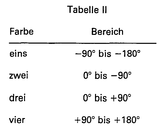
- the green of Figure 4 could represent 0 to -180° and the blue could represent 0 to +180°. However, the use of fewer than four colors will result in a loss of some information. Likewise, more than four colors could be utilized. However, again, the use of more than four colors will result in the loss of information as is more fully described hereinafter.
- Seismic peaks occur at 0° phase. Seismic troughs occur at + or -180° phase. Seismic zero crossings, such as point C illustrated in Figure 2, occur at + or -90° phase.
- the transition between colors can be set at phases other than 0°, 90° and 180°.
- an interpreter may be interested in a phase such as 50°.
- the transition between blue and pink in Figure 4 could be set at 50° and the other phases changed accordingly. This would enable the interpreter to determine the position of events occurring at 50° phase, 140° phase, etc.
- the information is sent to a plotter which generates the desired variable amplitude/phase seismic display.
- Any suitable plotter may be utilized.
- An example of a suitable plotter is the Applicon plotter.
- Any suitable computer program may be utilized to generate the variable amplitude/phase seismic display in accordance with the present invention.
- a suitable computer program for use with an IBM 3084 computer is set forth in Appendix I. The computer program is self explanatory to one skilled in the use of the IBM 3084 computer.
- peaks, troughs and zero crossings are very well defined.
- the very clear transition between blue and pink illustrates the location of peaks.
- the transition between green and blue illustrates zero crossings and the transition between green and orange illustrates troughs.
- variable amplitude/phase seismic display can be applied to three-dimensional seismic data.
- the present invention was applied to a time slice of the area covered by the seismic wiggle traces illustrated in Figure 3.
- the results is illustrated in Figure 7 using the color code of Figure 4.
- FIG. 7 A comparison of Figures 7 and 9 shows that more seismic information is available to the interpreter in Figure 7 than in Figure 9. In particular, the location of peaks, troughs and zero crossings are available from Figure 7 and are not available from Figure 9.
- the seismic display illustrated in Figure 5 was generated without interpolation with the result being as illustrated in Figure 10.
- the display illustrated in Figure 10 could be used but the blocky appearance is not visually appealing to an interpreter. Also the clarity of the seismic display of Figure 5 has been lost to some extent which would increase the difficulty of interpretation.
Landscapes
- Engineering & Computer Science (AREA)
- Remote Sensing (AREA)
- Physics & Mathematics (AREA)
- Life Sciences & Earth Sciences (AREA)
- Acoustics & Sound (AREA)
- Environmental & Geological Engineering (AREA)
- Geology (AREA)
- General Life Sciences & Earth Sciences (AREA)
- General Physics & Mathematics (AREA)
- Geophysics (AREA)
- Geophysics And Detection Of Objects (AREA)
- Image Processing (AREA)
Claims (9)

Applications Claiming Priority (2)
| Application Number | Priority Date | Filing Date | Title |
|---|---|---|---|
| US06/651,733 US4661935A (en) | 1984-09-17 | 1984-09-17 | Seismic data processing |
| US651733 | 1984-09-17 |
Publications (3)
| Publication Number | Publication Date |
|---|---|
| EP0175321A2 EP0175321A2 (de) | 1986-03-26 |
| EP0175321A3 EP0175321A3 (en) | 1987-02-04 |
| EP0175321B1 true EP0175321B1 (de) | 1990-08-29 |
Family
ID=24614006
Family Applications (1)
| Application Number | Title | Priority Date | Filing Date |
|---|---|---|---|
| EP85111683A Expired - Lifetime EP0175321B1 (de) | 1984-09-17 | 1985-09-16 | Verarbeitung von seismischen Daten |
Country Status (13)
| Country | Link |
|---|---|
| US (1) | US4661935A (de) |
| EP (1) | EP0175321B1 (de) |
| JP (1) | JPS6177785A (de) |
| AU (1) | AU558129B2 (de) |
| CA (1) | CA1221160A (de) |
| DE (1) | DE3579395D1 (de) |
| DK (1) | DK419585A (de) |
| ES (1) | ES8700449A1 (de) |
| HU (1) | HU191816B (de) |
| NO (1) | NO853625L (de) |
| SG (1) | SG3691G (de) |
| TR (1) | TR22753A (de) |
| YU (1) | YU142685A (de) |
Families Citing this family (22)
| Publication number | Priority date | Publication date | Assignee | Title |
|---|---|---|---|---|
| US4843599A (en) * | 1987-09-28 | 1989-06-27 | Amoco Corporation | Method for continuous color mapping of seismic data |
| US4964102A (en) * | 1988-04-19 | 1990-10-16 | Amoco Corporation | Method for enhancing and evaluating seismic data |
| US4970699A (en) * | 1989-02-13 | 1990-11-13 | Amoco Corporation | Method for color mapping geophysical data |
| EP0531515B1 (de) * | 1991-03-27 | 1995-08-23 | Exxon Production Research Company | Darstellung von n-dimensionalen seismischen Daten in einem n-1 dimensionalen Format |
| US5487001A (en) * | 1993-05-28 | 1996-01-23 | Neff; Dennis B. | Method for determining petrophysical properties of a subterranean layer |
| US5453958A (en) * | 1993-06-11 | 1995-09-26 | Phillips Petroleum Company | Method for locating hydrocarbon reservoirs |
| US5930730A (en) * | 1994-12-12 | 1999-07-27 | Amoco Corporation | Method and apparatus for seismic signal processing and exploration |
| USRE38229E1 (en) | 1994-12-12 | 2003-08-19 | Core Laboratories Global N.V. | Method and apparatus for seismic signal processing and exploration |
| US5563949A (en) * | 1994-12-12 | 1996-10-08 | Amoco Corporation | Method of seismic signal processing and exploration |
| US5831935A (en) * | 1996-03-05 | 1998-11-03 | Chevron U.S.A. Inc. | Method for geophysical processing and interpretation using seismic trace difference for analysis and display |
| US5724309A (en) * | 1996-03-06 | 1998-03-03 | Chevron U.S.A. Inc. | Method for geophysical processing and interpretation using instantaneous phase and its derivatives and their derivatives |
| US6665117B2 (en) * | 1999-05-06 | 2003-12-16 | Conocophillips Company | Method and apparatus for interactive curved surface borehole interpretation and visualization |
| US6424464B1 (en) * | 1999-05-06 | 2002-07-23 | Phillips Petroleum Company | Method and apparatus for interactive curved surface seismic interpretation and visualization |
| US6215499B1 (en) | 1999-05-06 | 2001-04-10 | Phillips Petroleum Company | Method and apparatus for interactive curved surface seismic interpretation and visualization |
| FR2808336B1 (fr) * | 2000-04-26 | 2002-06-07 | Elf Exploration Prod | Methode d'interpretation chrono-stratigraphique d'une section ou d'un bloc sismique |
| ES2329638B1 (es) | 2007-03-01 | 2010-10-13 | Fco. Javier Rodriguez Lorenzo | Maquina para el abonado en profundidad de los arboles. |
| CN102879799B (zh) * | 2011-07-15 | 2015-05-13 | 中国石油天然气集团公司 | 多方位地震能量梯度差碳酸盐岩溶洞型储层识别方法 |
| CN102508291B (zh) * | 2011-10-17 | 2014-01-15 | 中国石油天然气股份有限公司 | 横向变速小尺度体反射系数公式应用方法 |
| WO2013116844A1 (en) * | 2012-02-02 | 2013-08-08 | Headwave, Inc. | System, method, and computer-readable medium for interactive identification of subsurface regions |
| WO2014144970A2 (en) * | 2013-03-15 | 2014-09-18 | Orange Daniel L | System and method for calibration of echo sounding systems and improved seafloor imaging using such systems |
| RU2594377C1 (ru) * | 2013-05-15 | 2016-08-20 | Лэндмарк Графикс Корпорейшн | Стратиграфия сейсмических трасс для интерпретации геологических разломов |
| CN111323816B (zh) * | 2020-03-20 | 2021-12-14 | 中国海洋石油集团有限公司 | 基于海洋宽频地震数据波形的瞬时相位梯度属性提取方法 |
Family Cites Families (9)
| Publication number | Priority date | Publication date | Assignee | Title |
|---|---|---|---|---|
| US3781785A (en) * | 1970-01-26 | 1973-12-25 | Marathon Oil Co | Color sonagrams and methods for their production |
| GB1417552A (en) * | 1971-10-28 | 1975-12-10 | Seiscom Ltd | Wave form display in colour |
| FR2119761A5 (de) * | 1971-12-27 | 1972-08-04 | Subsea Equipment Ass Ltd | |
| JPS503677A (de) * | 1973-04-26 | 1975-01-16 | ||
| US3986160A (en) * | 1975-04-10 | 1976-10-12 | Automation Industries, Inc. | Visualization by ultrasonic detection |
| GB1547525A (en) * | 1976-08-02 | 1979-06-20 | Meshel L G | Selective colouring of soft contact lenses |
| US4467461A (en) * | 1981-01-05 | 1984-08-21 | Conoco Inc. | Interactive color analysis of geophysical data |
| FR2497578A1 (fr) * | 1981-01-07 | 1982-07-09 | Rech Const Electro Et | Procede et dispositif d'aide a la localisation d'une flute sismique marine |
| US4633399A (en) * | 1984-03-05 | 1986-12-30 | Conoco Inc. | Method of seismic data enhancement using a phase of rectified trace seismic parameter |
-
1984
- 1984-09-17 US US06/651,733 patent/US4661935A/en not_active Expired - Fee Related
-
1985
- 1985-08-02 CA CA000488002A patent/CA1221160A/en not_active Expired
- 1985-09-04 AU AU47049/85A patent/AU558129B2/en not_active Ceased
- 1985-09-11 YU YU01426/85A patent/YU142685A/xx unknown
- 1985-09-12 HU HU853444A patent/HU191816B/hu unknown
- 1985-09-16 ES ES547006A patent/ES8700449A1/es not_active Expired
- 1985-09-16 EP EP85111683A patent/EP0175321B1/de not_active Expired - Lifetime
- 1985-09-16 DK DK419585A patent/DK419585A/da not_active Application Discontinuation
- 1985-09-16 NO NO853625A patent/NO853625L/no unknown
- 1985-09-16 DE DE8585111683T patent/DE3579395D1/de not_active Revoked
- 1985-09-17 JP JP60205181A patent/JPS6177785A/ja active Pending
- 1985-09-17 TR TR38153A patent/TR22753A/xx unknown
-
1991
- 1991-01-22 SG SG36/91A patent/SG3691G/en unknown
Non-Patent Citations (1)
| Title |
|---|
| Geophysics,vol.44,no.6,June 1976,TANER ETAL,"Complex seismic trace analysis",pages 1041-1063 * |
Also Published As
| Publication number | Publication date |
|---|---|
| DE3579395D1 (de) | 1990-10-04 |
| NO853625L (no) | 1986-03-18 |
| EP0175321A2 (de) | 1986-03-26 |
| US4661935A (en) | 1987-04-28 |
| YU142685A (en) | 1991-04-30 |
| JPS6177785A (ja) | 1986-04-21 |
| ES547006A0 (es) | 1986-10-01 |
| ES8700449A1 (es) | 1986-10-01 |
| AU4704985A (en) | 1986-05-08 |
| AU558129B2 (en) | 1987-01-22 |
| DK419585D0 (da) | 1985-09-16 |
| EP0175321A3 (en) | 1987-02-04 |
| TR22753A (tr) | 1988-06-14 |
| SG3691G (en) | 1991-04-05 |
| HUT38448A (en) | 1986-05-28 |
| DK419585A (da) | 1986-03-18 |
| HU191816B (en) | 1987-04-28 |
| CA1221160A (en) | 1987-04-28 |
Similar Documents
| Publication | Publication Date | Title |
|---|---|---|
| EP0175321B1 (de) | Verarbeitung von seismischen Daten | |
| AU709621B2 (en) | Method and apparatus for seismic signal processing and exploration | |
| Short et al. | Geophysical methods | |
| USRE38229E1 (en) | Method and apparatus for seismic signal processing and exploration | |
| US4679174A (en) | Method for seismic lithologic modeling | |
| CA2220274C (en) | Method and apparatus for seismic signal processing and exploration | |
| US4794573A (en) | Process for separating upgoing and downgoing events on vertical seismic profiles | |
| US5995907A (en) | Seismic signal processing method and apparatus for generating time slice or horizon maps in response to seismic traces and quadrature traces to determine geologic features | |
| GB2161933A (en) | Method of seismic exploration | |
| US6571177B1 (en) | Color displays of multiple slices of 3-D seismic data | |
| Milkereit | Decomposition and inversion of seismic data–an instantaneous slowness approach | |
| US5097452A (en) | Analysis of migration velocity by migration of velocity spectra | |
| EP0317288B1 (de) | Verfahren zur Ausbreitung der lateralen Unteroberflächendeckung in vertikalen seismischen Messungen | |
| Rüter et al. | Investigation of the seismic response of cyclically layered carboniferous rock by means of synthetic seismograms | |
| US4987561A (en) | Seismic imaging of steeply dipping geologic interfaces | |
| Filson | Array seismology | |
| CA2204168C (en) | Method and apparatus for seismic signal processing and exploration | |
| Fertig et al. | Acquisition and processing of pure and converted shear waves generated by compressional wave sources | |
| Talagapu | 2d and 3d land seismic data acquisition and seismic data processing | |
| Ma et al. | 3D seismic volume visualization | |
| Stucchi et al. | Comparison between reprocessed seismic profiles: Seismologic and geologic data—A case study of the Colfiorito earthquake area | |
| Talwani et al. | Seismic multichannel towed arrays in the exploration of the oceanic crust | |
| Miao et al. | Three component vertical seismic profiling (VSP) experiment in the Sudbury Basin | |
| Krasovec | Subsurface imaging with reverse vertical seismic profiles | |
| Stommel et al. | Current trends in geophysics |
Legal Events
| Date | Code | Title | Description |
|---|---|---|---|
| PUAI | Public reference made under article 153(3) epc to a published international application that has entered the european phase |
Free format text: ORIGINAL CODE: 0009012 |
|
| AK | Designated contracting states |
Kind code of ref document: A2 Designated state(s): BE DE FR GB IT NL |
|
| PUAL | Search report despatched |
Free format text: ORIGINAL CODE: 0009013 |
|
| AK | Designated contracting states |
Kind code of ref document: A3 Designated state(s): BE DE FR GB IT NL |
|
| 17P | Request for examination filed |
Effective date: 19870629 |
|
| 17Q | First examination report despatched |
Effective date: 19890221 |
|
| GRAA | (expected) grant |
Free format text: ORIGINAL CODE: 0009210 |
|
| AK | Designated contracting states |
Kind code of ref document: B1 Designated state(s): BE DE FR GB IT NL |
|
| REF | Corresponds to: |
Ref document number: 3579395 Country of ref document: DE Date of ref document: 19901004 |
|
| ITF | It: translation for a ep patent filed | ||
| ET | Fr: translation filed | ||
| PLBI | Opposition filed |
Free format text: ORIGINAL CODE: 0009260 |
|
| 26 | Opposition filed |
Opponent name: PRAKLA- SEISMOS AG Effective date: 19910525 |
|
| PGFP | Annual fee paid to national office [announced via postgrant information from national office to epo] |
Ref country code: GB Payment date: 19910809 Year of fee payment: 7 |
|
| PGFP | Annual fee paid to national office [announced via postgrant information from national office to epo] |
Ref country code: FR Payment date: 19910825 Year of fee payment: 7 |
|
| PGFP | Annual fee paid to national office [announced via postgrant information from national office to epo] |
Ref country code: DE Payment date: 19910829 Year of fee payment: 7 |
|
| PGFP | Annual fee paid to national office [announced via postgrant information from national office to epo] |
Ref country code: BE Payment date: 19910912 Year of fee payment: 7 |
|
| NLR1 | Nl: opposition has been filed with the epo |
Opponent name: PRAKLA-SEISMOS AG |
|
| ITTA | It: last paid annual fee | ||
| PGFP | Annual fee paid to national office [announced via postgrant information from national office to epo] |
Ref country code: NL Payment date: 19910930 Year of fee payment: 7 |
|
| RDAG | Patent revoked |
Free format text: ORIGINAL CODE: 0009271 |
|
| STAA | Information on the status of an ep patent application or granted ep patent |
Free format text: STATUS: PATENT REVOKED |
|
| 27W | Patent revoked |
Effective date: 19920312 |
|
| GBPR | Gb: patent revoked under art. 102 of the ep convention designating the uk as contracting state | ||
| NLR2 | Nl: decision of opposition | ||
| BERE | Be: lapsed |
Owner name: PHILLIPS PETROLEUM CY Effective date: 19920930 |