DE102019123778A1 - Representing a vehicle environment for moving the vehicle to a target position - Google Patents
Representing a vehicle environment for moving the vehicle to a target position Download PDFInfo
- Publication number
- DE102019123778A1 DE102019123778A1 DE102019123778.5A DE102019123778A DE102019123778A1 DE 102019123778 A1 DE102019123778 A1 DE 102019123778A1 DE 102019123778 A DE102019123778 A DE 102019123778A DE 102019123778 A1 DE102019123778 A1 DE 102019123778A1
- Authority
- DE
- Germany
- Prior art keywords
- vehicle
- surroundings
- obstacle
- camera
- environment
- Prior art date
- Legal status (The legal status is an assumption and is not a legal conclusion. Google has not performed a legal analysis and makes no representation as to the accuracy of the status listed.)
- Pending
Links
Images


Classifications
-
- B—PERFORMING OPERATIONS; TRANSPORTING
- B60—VEHICLES IN GENERAL
- B60R—VEHICLES, VEHICLE FITTINGS, OR VEHICLE PARTS, NOT OTHERWISE PROVIDED FOR
- B60R1/00—Optical viewing arrangements; Real-time viewing arrangements for drivers or passengers using optical image capturing systems, e.g. cameras or video systems specially adapted for use in or on vehicles
- B60R1/20—Real-time viewing arrangements for drivers or passengers using optical image capturing systems, e.g. cameras or video systems specially adapted for use in or on vehicles
- B60R1/22—Real-time viewing arrangements for drivers or passengers using optical image capturing systems, e.g. cameras or video systems specially adapted for use in or on vehicles for viewing an area outside the vehicle, e.g. the exterior of the vehicle
- B60R1/23—Real-time viewing arrangements for drivers or passengers using optical image capturing systems, e.g. cameras or video systems specially adapted for use in or on vehicles for viewing an area outside the vehicle, e.g. the exterior of the vehicle with a predetermined field of view
- B60R1/27—Real-time viewing arrangements for drivers or passengers using optical image capturing systems, e.g. cameras or video systems specially adapted for use in or on vehicles for viewing an area outside the vehicle, e.g. the exterior of the vehicle with a predetermined field of view providing all-round vision, e.g. using omnidirectional cameras
-
- B—PERFORMING OPERATIONS; TRANSPORTING
- B60—VEHICLES IN GENERAL
- B60R—VEHICLES, VEHICLE FITTINGS, OR VEHICLE PARTS, NOT OTHERWISE PROVIDED FOR
- B60R11/00—Arrangements for holding or mounting articles, not otherwise provided for
- B60R11/04—Mounting of cameras operative during drive; Arrangement of controls thereof relative to the vehicle
-
- G—PHYSICS
- G06—COMPUTING; CALCULATING OR COUNTING
- G06V—IMAGE OR VIDEO RECOGNITION OR UNDERSTANDING
- G06V20/00—Scenes; Scene-specific elements
- G06V20/50—Context or environment of the image
- G06V20/56—Context or environment of the image exterior to a vehicle by using sensors mounted on the vehicle
- G06V20/58—Recognition of moving objects or obstacles, e.g. vehicles or pedestrians; Recognition of traffic objects, e.g. traffic signs, traffic lights or roads
- G06V20/586—Recognition of moving objects or obstacles, e.g. vehicles or pedestrians; Recognition of traffic objects, e.g. traffic signs, traffic lights or roads of parking space
-
- G—PHYSICS
- G08—SIGNALLING
- G08G—TRAFFIC CONTROL SYSTEMS
- G08G1/00—Traffic control systems for road vehicles
- G08G1/16—Anti-collision systems
- G08G1/168—Driving aids for parking, e.g. acoustic or visual feedback on parking space
-
- B—PERFORMING OPERATIONS; TRANSPORTING
- B60—VEHICLES IN GENERAL
- B60R—VEHICLES, VEHICLE FITTINGS, OR VEHICLE PARTS, NOT OTHERWISE PROVIDED FOR
- B60R2300/00—Details of viewing arrangements using cameras and displays, specially adapted for use in a vehicle
- B60R2300/10—Details of viewing arrangements using cameras and displays, specially adapted for use in a vehicle characterised by the type of camera system used
- B60R2300/105—Details of viewing arrangements using cameras and displays, specially adapted for use in a vehicle characterised by the type of camera system used using multiple cameras
-
- B—PERFORMING OPERATIONS; TRANSPORTING
- B60—VEHICLES IN GENERAL
- B60R—VEHICLES, VEHICLE FITTINGS, OR VEHICLE PARTS, NOT OTHERWISE PROVIDED FOR
- B60R2300/00—Details of viewing arrangements using cameras and displays, specially adapted for use in a vehicle
- B60R2300/30—Details of viewing arrangements using cameras and displays, specially adapted for use in a vehicle characterised by the type of image processing
- B60R2300/301—Details of viewing arrangements using cameras and displays, specially adapted for use in a vehicle characterised by the type of image processing combining image information with other obstacle sensor information, e.g. using RADAR/LIDAR/SONAR sensors for estimating risk of collision
-
- B—PERFORMING OPERATIONS; TRANSPORTING
- B60—VEHICLES IN GENERAL
- B60R—VEHICLES, VEHICLE FITTINGS, OR VEHICLE PARTS, NOT OTHERWISE PROVIDED FOR
- B60R2300/00—Details of viewing arrangements using cameras and displays, specially adapted for use in a vehicle
- B60R2300/30—Details of viewing arrangements using cameras and displays, specially adapted for use in a vehicle characterised by the type of image processing
- B60R2300/303—Details of viewing arrangements using cameras and displays, specially adapted for use in a vehicle characterised by the type of image processing using joined images, e.g. multiple camera images
-
- B—PERFORMING OPERATIONS; TRANSPORTING
- B60—VEHICLES IN GENERAL
- B60R—VEHICLES, VEHICLE FITTINGS, OR VEHICLE PARTS, NOT OTHERWISE PROVIDED FOR
- B60R2300/00—Details of viewing arrangements using cameras and displays, specially adapted for use in a vehicle
- B60R2300/30—Details of viewing arrangements using cameras and displays, specially adapted for use in a vehicle characterised by the type of image processing
- B60R2300/307—Details of viewing arrangements using cameras and displays, specially adapted for use in a vehicle characterised by the type of image processing virtually distinguishing relevant parts of a scene from the background of the scene
- B60R2300/308—Details of viewing arrangements using cameras and displays, specially adapted for use in a vehicle characterised by the type of image processing virtually distinguishing relevant parts of a scene from the background of the scene by overlaying the real scene, e.g. through a head-up display on the windscreen
-
- B—PERFORMING OPERATIONS; TRANSPORTING
- B60—VEHICLES IN GENERAL
- B60R—VEHICLES, VEHICLE FITTINGS, OR VEHICLE PARTS, NOT OTHERWISE PROVIDED FOR
- B60R2300/00—Details of viewing arrangements using cameras and displays, specially adapted for use in a vehicle
- B60R2300/60—Details of viewing arrangements using cameras and displays, specially adapted for use in a vehicle characterised by monitoring and displaying vehicle exterior scenes from a transformed perspective
- B60R2300/607—Details of viewing arrangements using cameras and displays, specially adapted for use in a vehicle characterised by monitoring and displaying vehicle exterior scenes from a transformed perspective from a bird's eye viewpoint
-
- B—PERFORMING OPERATIONS; TRANSPORTING
- B60—VEHICLES IN GENERAL
- B60R—VEHICLES, VEHICLE FITTINGS, OR VEHICLE PARTS, NOT OTHERWISE PROVIDED FOR
- B60R2300/00—Details of viewing arrangements using cameras and displays, specially adapted for use in a vehicle
- B60R2300/80—Details of viewing arrangements using cameras and displays, specially adapted for use in a vehicle characterised by the intended use of the viewing arrangement
- B60R2300/806—Details of viewing arrangements using cameras and displays, specially adapted for use in a vehicle characterised by the intended use of the viewing arrangement for aiding parking
-
- B—PERFORMING OPERATIONS; TRANSPORTING
- B60—VEHICLES IN GENERAL
- B60R—VEHICLES, VEHICLE FITTINGS, OR VEHICLE PARTS, NOT OTHERWISE PROVIDED FOR
- B60R2300/00—Details of viewing arrangements using cameras and displays, specially adapted for use in a vehicle
- B60R2300/80—Details of viewing arrangements using cameras and displays, specially adapted for use in a vehicle characterised by the intended use of the viewing arrangement
- B60R2300/8093—Details of viewing arrangements using cameras and displays, specially adapted for use in a vehicle characterised by the intended use of the viewing arrangement for obstacle warning
Landscapes
- Engineering & Computer Science (AREA)
- Multimedia (AREA)
- Physics & Mathematics (AREA)
- General Physics & Mathematics (AREA)
- Mechanical Engineering (AREA)
- Theoretical Computer Science (AREA)
- Traffic Control Systems (AREA)
- Closed-Circuit Television Systems (AREA)
Abstract
Die Erfindung betrifft ein Verfahren zum Darstellen einer Umgebung (16) eines Fahrzeugs (10), wobei das Fahrzeug (10) ein kamerabasiertes Umgebungserfassungssystem (14) aufweist zur Erfassung der Umgebung (16) des Fahrzeugs (10), Bewegen des Fahrzeugs (10) zu einer Zielposition (24) in der Umgebung (16), umfassend die Schritte Bereitstellen von Bildern der Umgebung (16) des Fahrzeugs (10) mit dem kamerabasierten Umgebungserfassungssystem (14), Erzeugen eines Umgebungsbildes (26) in einer Vogelperspektive basierend auf den mit dem kamerabasierten Umgebungserfassungssystem (14) bereitgestellten Bildern der Umgebung (16) des Fahrzeugs (10), Bestimmen wenigstens einer Zielposition (24) in der Umgebung (16) des Fahrzeugs (10), Darstellen der wenigstens einen Zielposition (24) in einer ersten Überlagerungsebene, welche die Umgebung (16) des Fahrzeugs (10) abdeckt, und Überlagern des Umgebungsbildes (26) mit der ersten Überlagerungsebene. Die Erfindung betrifft außerdem ein entsprechendes Fahrunterstützungssystem (10), das ausgeführt ist, das obige Verfahren durchzuführen.The invention relates to a method for displaying the surroundings (16) of a vehicle (10), the vehicle (10) having a camera-based environment detection system (14) for detecting the surroundings (16) of the vehicle (10), moving the vehicle (10) to a target position (24) in the surroundings (16), comprising the steps of providing images of the surroundings (16) of the vehicle (10) with the camera-based surroundings detection system (14), generating an image of the surroundings (26) in a bird's eye view based on the the camera-based environment detection system (14) provided images of the environment (16) of the vehicle (10), determining at least one target position (24) in the environment (16) of the vehicle (10), displaying the at least one target position (24) in a first overlay plane which covers the environment (16) of the vehicle (10), and superimposing the environment image (26) with the first overlay plane. The invention also relates to a corresponding driving support system (10) which is designed to carry out the above method.
Description
Die vorliegende Erfindung betrifft ein Verfahren zum Darstellen einer Umgebung eines Fahrzeugs, wobei das Fahrzeug ein kamerabasiertes Umgebungserfassungssystem aufweist zur Erfassung der Umgebung des Fahrzeugs, zum Bewegen des Fahrzeugs zu einer Zielposition in der Umgebung.The present invention relates to a method for displaying the surroundings of a vehicle, the vehicle having a camera-based surroundings detection system for detecting the surroundings of the vehicle, for moving the vehicle to a target position in the surroundings.
Auch betrifft die vorliegende Erfindung ein Fahrunterstützungssystem zum Darstellen einer Umgebung eines Fahrzeugs, mit einem kamerabasierten Umgebungserfassungssystem zur Erfassung der Umgebung des Fahrzeugs, und einer Verarbeitungseinheit, welche Bilder der Umgebung des Fahrzeugs empfängt, wobei das Fahrunterstützungssystem ausgeführt ist, das obige Verfahren durchzuführen.The present invention also relates to a driving support system for displaying the surroundings of a vehicle, with a camera-based environment detection system for detecting the surroundings of the vehicle, and a processing unit which receives images of the surroundings of the vehicle, the driving support system being designed to carry out the above method.
Es sind verschiedenartige Assistenzfunktionen oder auch allgemein Fahrunterstützungssysteme zum Bewegen eines Fahrzeugs zu einer Zielposition bekannt. Dies betrifft beispielsweise das Parken von Fahrzeugen auf einem Parkplatz in der Umgebung, wobei der Parkplatz die Zielposition darstellt. So können entsprechende Assistenzsysteme beispielsweise eine Umgebung des Fahrzeugs erfassen, um bereits beim Erkennen von Parkplätzen oder anderen Zielpositionen zu helfen. Weiterhin können diese Systeme helfen, eine optimale Trajektorie zu bestimmen, der ein Fahrzeugführer folgen kann, um das Fahrzeug auf einem Parkplatz zu parken oder eine beliebige Zielposition zu erreichen.Various types of assistance functions or generally driving support systems for moving a vehicle to a target position are known. This concerns, for example, the parking of vehicles in a parking lot in the vicinity, the parking lot being the target position. Corresponding assistance systems can, for example, capture the surroundings of the vehicle in order to help identify parking spaces or other target positions. Furthermore, these systems can help to determine an optimal trajectory that a vehicle driver can follow in order to park the vehicle in a parking lot or to reach any target position.
Darüber hinaus sind beispielsweise autonomes oder teil-autonomes Parken wichtige Funktionen für aktuelle Fahrzeuge, die auch bereits in verschiedenen Fahrunterstützungssystemen Verwendung in diesen Fahrzeugen findet und das Parken erleichtert. Dabei wird das jeweilige Fahrzeug autonom oder teil-autonom auf einen erfassten Parkplatz manövriert. Dabei kann es dem Fahrzeugführer ermöglicht werden, dass Fahrzeug vor der Durchführung des Parkvorgangs bereits zu verlassen. Solche Funktionen sind beispielsweise bekannt, um das Fahrzeug nach dem Verlassen autonom in einer heimischen Garage zu parken oder auf einem beliebigen heimischen Stellplatz abzustellen.In addition, for example, autonomous or partially autonomous parking are important functions for current vehicles, which are already used in various driving support systems in these vehicles and which make parking easier. The respective vehicle is maneuvered autonomously or partially autonomously to a recorded parking space. It can be made possible for the driver of the vehicle to leave the vehicle before the parking process is carried out. Such functions are known, for example, to park the vehicle autonomously in a home garage after leaving it or to park it in any home parking space.
Insbesondere in Ballungsräumen sind Parkplätze oftmals rar, und das Einparken wie auch das Ausparken kann sich zeitaufwändig gestalten. Daher sind weitere Verbesserungen beim Parken von Fahrzeugen wünschenswert.Parking spaces are often rare, especially in metropolitan areas, and parking and exiting can be time-consuming. Therefore, further improvements in vehicle parking are desirable.
Zur Bewegung des Fahrzeugs zu einer Zielposition ist es oftmals hilfreich, einem Führer eines Fahrzeugs Details zu der Bewegung des Fahrzeugs zu der Zielposition zu visualisieren. Dadurch kann das Vertrauen in das autonome bzw. teilautonome Bewegen des Fahrzeugs erhöht und damit die Akzeptanz dieser Funktionen signifikant verbessert werden. Zur Darstellung der Details zu der Bewegung des Fahrzeugs zu der Zielposition, insbesondere zu einem Parkplatz in der Umgebung des Fahrzeugs, wird ein üblicherweise in dem Fahrzeug befindliches User Interface des Fahrzeugs mit einem Bildschirm verwendet. Dabei ist es wichtig, dass der Fahrzeugführer die Darstellung der Details mit seiner eigenen Wahrnehmung der Umgebung des Fahrzeugs möglichst einfach abgleichen kann.To move the vehicle to a target position, it is often helpful to visualize details of the movement of the vehicle to the target position to a driver of a vehicle. As a result, confidence in the autonomous or semi-autonomous movement of the vehicle can be increased and the acceptance of these functions can be significantly improved. A user interface of the vehicle with a screen, which is usually located in the vehicle, is used to display the details of the movement of the vehicle to the target position, in particular to a parking space in the vicinity of the vehicle. It is important that the vehicle driver can compare the display of the details with his own perception of the vehicle's surroundings as easily as possible.
Zur Darstellung der Details zu der Bewegung des Fahrzeugs zu der Zielposition sind dabei verschiedene Konzepte bekannt. So kann beispielsweise eine Darstellung einer künstlich erzeugten Fahrzeugumgebung inkl. der Details zu der Bewegung des Fahrzeugs zu der Zielposition vorgenommen werden. Dazu wird typischerweise eine schematische Darstellung, die mit der realen Umgebung, wie sie von dem Fahrzeugführer wahrgenommen wird, nur wenige Übereinstimmungen aufweist, verwendet.Various concepts are known for displaying the details of the movement of the vehicle to the target position. For example, an artificially generated vehicle environment including the details of the movement of the vehicle to the target position can be displayed. For this purpose, a schematic representation is typically used which has only a few matches with the real environment as perceived by the vehicle driver.
Auch sind prinzipiell Darstellungen mit einer 360°-Ansicht aus einer Vogelperspektive mit realen Kamerabildern bekannt. Diese Darstellungen basieren auf einem kamerabasierten Umgebungserfassungssystem, das eine 360°-Erfassung der Umgebung durchführt. Solche kamerabasierten Umgebungserfassungssysteme umfassen beispielsweise ein Surroundview-Kamerasystem mit vier Kameras, die an dem Fahrzeug angebracht sind. Dabei erfolgt aber eine Verzerrung der realen Umgebung des Fahrzeugs, was einen Abgleich mit der realen Umgebung erschwert. Prinzipiell sind auch vergleichbare Darstellungen nach der Art eines Bowl View (Schüsselansicht) oder eines adaptiven Bowl View bekannt, welche diese Probleme teilweise reduzieren. Insgesamt besteht noch Verbesserungsbedarf bei der Darstellung von relevanten Informationen zur Bewegung des Fahrzeugs zu der Zielposition.In principle, representations with a 360 ° view from a bird's eye view with real camera images are also known. These representations are based on a camera-based environment detection system that carries out a 360 ° detection of the environment. Such camera-based environment detection systems include, for example, a surround view camera system with four cameras that are attached to the vehicle. However, this results in a distortion of the real environment of the vehicle, which makes comparison with the real environment more difficult. In principle, comparable representations of the type of a bowl view or an adaptive bowl view are also known, which partially reduce these problems. Overall, there is still a need for improvement in the representation of relevant information on the movement of the vehicle to the target position.
Aus der
Die
Die
Ausgehend von dem oben genannten Stand der Technik liegt der Erfindung somit die Aufgabe zugrunde, ein Verfahren zum Darstellen einer Umgebung eines Fahrzeugs, wobei das Fahrzeug ein kamerabasiertes Umgebungserfassungssystem aufweist zur Erfassung der Umgebung des Fahrzeugs, zum Bewegen des Fahrzeugs zu einer Zielposition in der Umgebung und ein entsprechendes Fahrunterstützungssystem anzugeben, die ein einfaches Bewegen des Fahrzeugs zu der Zielposition in der Umgebung des Fahrzeugs ermöglichen.Starting from the above-mentioned prior art, the invention is therefore based on the object of providing a method for displaying the surroundings of a vehicle, the vehicle having a camera-based surroundings detection system for detecting the surroundings of the vehicle, for moving the vehicle to a target position in the surroundings and specify a corresponding driving support system, which allow easy movement of the vehicle to the target position in the vicinity of the vehicle.
Die Lösung der Aufgabe erfolgt erfindungsgemäß durch die Merkmale der unabhängigen Ansprüche. Vorteilhafte Ausgestaltungen der Erfindung sind in den Unteransprüchen angegeben.The object is achieved according to the invention by the features of the independent claims. Advantageous refinements of the invention are given in the subclaims.
Erfindungsgemäß ist somit ein Verfahren zum Darstellen einer Umgebung eines Fahrzeugs angegeben, wobei das Fahrzeug ein kamerabasiertes Umgebungserfassungssystem aufweist zur Erfassung der Umgebung des Fahrzeugs, zum Bewegen des Fahrzeugs zu einer Zielposition in der Umgebung, umfassend die Schritte Bereitstellen von Bildern der Umgebung des Fahrzeugs mit dem kamerabasierten Umgebungserfassungssystem, Erzeugen eines Umgebungsbildes in einer Vogelperspektive basierend auf den mit dem kamerabasierten Umgebungserfassungssystem bereitgestellten Bildern der Umgebung des Fahrzeugs, Bestimmen wenigstens einer Zielposition in der Umgebung des Fahrzeugs, Darstellen der wenigstens einen Zielposition in einer ersten Überlagerungsebene, welche die Umgebung des Fahrzeugs abdeckt, und Überlagern des Umgebungsbildes mit der ersten Überlagerungsebene.According to the invention, a method for displaying the surroundings of a vehicle is thus specified, the vehicle having a camera-based surroundings detection system for detecting the surroundings of the vehicle, for moving the vehicle to a target position in the surroundings, comprising the steps of providing images of the surroundings of the vehicle with the camera-based environment detection system, generation of an image of the surroundings in a bird's eye view based on the images of the surroundings of the vehicle provided with the camera-based surroundings detection system, determination of at least one target position in the surroundings of the vehicle, display of the at least one target position in a first overlay plane which covers the surroundings of the vehicle, and overlaying the environmental image with the first overlay layer.
Erfindungsgemäß ist außerdem ein Fahrunterstützungssystem zum Darstellen einer Umgebung eines Fahrzeugs angegeben, mit einem kamerabasierten Umgebungserfassungssystem zur Erfassung der Umgebung des Fahrzeugs, und einer Verarbeitungseinheit, welche Bilder der Umgebung des Fahrzeugs empfängt, wobei das Fahrunterstützungssystem ausgeführt ist, das obige Verfahren durchzuführen.According to the invention, a driving support system for displaying the surroundings of a vehicle is also specified, with a camera-based environment detection system for detecting the surroundings of the vehicle, and a processing unit which receives images of the surroundings of the vehicle, the driving support system being designed to carry out the above method.
Grundidee der vorliegenden Erfindung ist es also, eine Verbesserung beim Bewegen von Fahrzeugen zu einer Zielposition zu erreichen, indem eine möglichst intuitive Darstellung von Zielinformation wie z.B. einer Zielposition in der Umgebung des Fahrzeugs, erfolgt, so dass ein Fahrzeugführer in die Lage versetzt wird, mit geringem Zeitaufwand die Zielinformation zuverlässig zu verarbeiten. Dazu wird mit dem vorliegenden Verfahren eine Darstellung ermöglicht, die einerseits realitätsnah ist und einen hohen Grad an optischer Übereinstimmung mit der Umgebung des Fahrzeugs, wie sie auch von dem Fahrzeugführer wahrgenommen wird, aufweist, und andererseits zusätzliche Informationen basierend auf einer Verarbeitung von Sensorinformation betreffend die Umgebung des Fahrzeugs in der Form einer ersten Überlagerungsebene bereitstellt. Dadurch kann die zusätzliche Information einfach dargestellt werden, indem lediglich eine entsprechende Überlagerung des Umgebungsbildes in der Vogelperspektive mit der Information der ersten Überlagerungsebene erfolgt.The basic idea of the present invention is therefore to achieve an improvement in the movement of vehicles to a target position by making target information such as a target position in the vicinity of the vehicle as intuitive as possible, so that a vehicle driver is able to use to process the target information reliably in a short time. For this purpose, the present method enables a representation that on the one hand is realistic and has a high degree of optical correspondence with the surroundings of the vehicle, as it is also perceived by the vehicle driver, and on the other hand additional information based on processing of sensor information relating to the Provides environment of the vehicle in the form of a first overlay plane. As a result, the additional information can be displayed simply by simply superimposing the image of the surroundings in a bird's eye view with the information from the first superimposition level.
Das Fahrzeug kann ein prinzipiell beliebiges Fahrzeug sein. Das Fahrzeug ist vorzugsweise zum autonomen oder teil-autonomen Manövrieren zum Bewegen zu der Zielposition ausgeführt, insbesondere zum Parken des Fahrzeugs. Dabei kann es dem Fahrzeugführer ermöglicht werden, dass Fahrzeug vor der Durchführung einer Bewegung zu der Zielposition bereits zu verlassen.The vehicle can in principle be any vehicle. The vehicle is preferably designed for autonomous or partially autonomous maneuvering to move to the target position, in particular for parking the vehicle. It can be made possible for the driver of the vehicle to leave the vehicle before a movement to the target position is carried out.
Das Fahrunterstützungssystem stellt eine Fahrerassistenzfunktion oder allgemein eine Fahrunterstützungsfunktion bereit. Durch die Fahrerassistenzfunktion kann beispielsweise eine Umgebung des Fahrzeugs erfasst werden, um die wenigstens eine Zielposition zu bestimmen und ggf. eine optimale Trajektorie zu bestimmen, der ein Fahrzeugführer folgen kann, um das Fahrzeug zu der Zielposition zu bewegen.The driving support system provides a driver assistance function or, in general, a driving support function. The driver assistance function can, for example, detect the surroundings of the vehicle in order to determine the at least one target position and, if necessary, to determine an optimal trajectory that a vehicle driver can follow in order to move the vehicle to the target position.
Abhängig von der Art des Fahrunterstützungssystems kann die Zielposition beispielsweise ein Parkplatz zum Parken des Fahrzeugs sein. Beim Valet Parken kann die Zielposition ein Übergabepunkt zur Übergabe des Fahrzeugs an den Valet sein. Bei anderen Fahrunterstützungssystemen, wie beispielsweise einem automatischen Garagenparken, kann die Zielposition durch die Garage definiert sein. Beim gelernten Parken kann die Zielposition eine beliebige gelernte Parkposition sein, die unabhängig von einem vorgegebenen Parkplatz ist. Hierbei handelt es sich um eine beispielhafte, nicht abschließende Aufzählung möglicher Zielpositionen.Depending on the type of driving support system, the target position can be, for example, a parking space for parking the vehicle. With valet parking, the target position can be a handover point for handing over the vehicle to the valet. In other driving support systems, such as automatic garage parking, the target position can be defined by the garage. In the case of learned parking, the target position can be any learned parking position that is independent of a predetermined parking space. This is an exemplary, non-exhaustive list of possible target positions.
Die Umgebung betrifft einen Bereich um das Fahrzeug. Hiermit ist üblicherweise ein Bereich innerhalb eines Erfassungsbereichs von Umgebungssensoren des Fahrzeugs gemeint, d.h. ein Bereich in einem Radius von beispielsweise 5-50 Metern um das Fahrzeug, vorzugsweise in einem Radius von nicht mehr als etwa 20 Metern. Darüber hinaus kann der Bereich durch vorab von den Umgebungssensoren empfangene und gespeicherte Sensorinformation prinzipiell darüber hinaus erweitert werden.The environment relates to an area around the vehicle. This usually means an area within a detection area of environmental sensors of the vehicle, i.e. an area in a radius of, for example, 5-50 meters around the vehicle, preferably in a radius of no more than approximately 20 meters. In addition, the area can in principle be expanded by sensor information received and stored in advance by the environmental sensors.
Das Darstellen der Umgebung des Fahrzeugs umfasst eine Ausgabe von Information über eine grafische Benutzerschnittstelle in dem Fahrzeug, beispielsweise mit einem Bildschirm, vorzugsweise mit einem berührungsempfindlichen Bildschirm, um zusätzlich Eingaben des Fahrzeugführers zu empfangen.Displaying the surroundings of the vehicle includes outputting information via a graphical user interface in the vehicle, for example with a screen, preferably with a touch-sensitive screen, in order to additionally receive inputs from the vehicle driver.
Das kamerabasierte Umgebungserfassungssystem ermöglicht eine 360°-Erfassung der Umgebung. Solche kamerabasierten Umgebungserfassungssysteme umfassen beispielsweise ein Surroundview-Kamerasystem mit vier Kameras, die an dem Fahrzeug angebracht sind, d.h. an jeder Seite des Fahrzeugs ist eine der Kameras angebracht. Die Kameras sind vorzugsweise Weitwinkelkameras mit einem Öffnungswinkel von etwa 170°-180°. Durch diese vier Kameras können jeweils vier Bilder bereitgestellt werden, die gemeinsam die Umgebung des Fahrzeugs vollständig abdecken, d.h. eine 360°-Ansicht ermöglichen. Entsprechend werden Bilder der Umgebung des Fahrzeugs mit dem kamerabasierten Umgebungserfassungssystem zunächst als eine Mehrzahl Einzelbilder bereitgestellt.The camera-based environment detection system enables 360 ° detection of the environment. Such camera-based environment detection systems include, for example, a surround view camera system with four cameras that are attached to the vehicle, i.e. one of the cameras is attached to each side of the vehicle. The cameras are preferably wide-angle cameras with an opening angle of approximately 170 ° -180 °. These four cameras can each provide four images that together completely cover the area around the vehicle, i.e. enable a 360 ° view. Accordingly, images of the surroundings of the vehicle with the camera-based surroundings detection system are initially provided as a plurality of individual images.
Das Erzeugen eines Umgebungsbildes in der Vogelperspektive umfasst somit typischerweise eine Verarbeitung der Mehrzahl Einzelbilder, die von dem kamerabasierten Umgebungserfassungssystem gemeinsam bereitgestellt werden. Die Bilder werden entsprechend verarbeitet und/oder kombiniert, um die 360°-Ansicht zu erzeugen.The generation of an image of the surroundings in the bird's eye view thus typically includes processing of the plurality of individual images which are jointly provided by the camera-based surroundings detection system. The images are processed and / or combined accordingly in order to generate the 360 ° view.
Das Bestimmen wenigstens einer Zielposition in der Umgebung des Fahrzeugs kann auf unterschiedliche Weise erfolgen. Dazu kann Sensorinformation unmittelbar verarbeitet werden, um die wenigstens eine Zielposition zu bestimmen. Alternativ oder zusätzlich kann beispielsweise basierend auf der Sensorinformation zunächst eine Umgebungskarte erzeugt werden, auf deren Basis dann die wenigstens eine Zielposition bestimmt wird. Das Bestimmen der Zielposition kann beispielsweise ein Erkennen eines Parkplatzes basierend auf Linienmarkierungen, Schildern oder anderen Kennzeichnungen, ein identifizieren eines Übergabepunktes an den Valet oder ein erkennen einer Garage umfassen.At least one target position in the vicinity of the vehicle can be determined in different ways. For this purpose, sensor information can be processed directly in order to determine the at least one target position. Alternatively or additionally, for example, based on the sensor information, a map of the surroundings can first be generated, on the basis of which the at least one target position is then determined. Determining the target position can include, for example, recognizing a parking space based on line markings, signs or other markings, identifying a transfer point to the valet, or recognizing a garage.
Das Darstellen der wenigstens einen Zielposition in der ersten Überlagerungsebene betrifft eine Repräsentation der Zielposition zum Bewegen des Fahrzeugs. Die Zielposition wird vorzugsweise mit einer Begrenzungslinie, welche die Zielposition vollständig oder teilweise umgibt, dargestellt. Prinzipiell kann die Zielposition auch mit einer farblich abgesetzten Fläche oder mit einer Kontourlinie mit Umrissen des eigenen, zu der Zielposition zu bewegenden Fahrzeugs dargestellt werden. Die Zielposition kann eine exakte Position sein, oder beispielsweise ein Fenster definieren, in das das Fahrzeug bewegt wird. Entsprechend kann das Darstellen der jeweiligen Zielposition in der ersten Überlagerungsebene auf prinzipiell unterschiedliche Weisen erfolgen.The representation of the at least one target position in the first superimposition level relates to a representation of the target position for moving the vehicle. The target position is preferably shown with a boundary line which completely or partially surrounds the target position. In principle, the target position can also be represented with a color-contrasting area or with a contour line with the outlines of the vehicle that is to be moved to the target position. The target position can be an exact position or, for example, define a window into which the vehicle is moved. Correspondingly, the respective target position can be represented in the first superimposition plane in basically different ways.
Durch das Überlagern des Umgebungsbildes mit der ersten Überlagerungsebene erfolgt eine kombinierte Darstellung von dem Umgebungsbild, wie es von dem Fahrzeugführer wahrgenommen wird, mit der Zielinformation, die hier eine Zielposition in der Umgebung des Fahrzeugs betrifft. Das Überlagern bedeutet dabei, dass vorhandene Teile des Umgebungsbildes durch die Überlagerungsebene ersetzt oder ergänzt werden, beispielsweise durch eine teilweise durchsichtige Überlagerung. Dabei ist es nicht erforderlich, dass das Umgebungsbild eine Bildfläche vollständig ausfüllt, was auch beispielsweise bei einer Abschattung von Teilen der Umgebung durch Hindernisse nicht möglich ist. Das Umgebungsbild kann auch lediglich mit Bildinformation der ersten Überlagerungsebene ergänzt werden.By superimposing the image of the surroundings with the first overlay level, there is a combined display of the image of the surroundings as perceived by the vehicle driver with the target information, which here relates to a target position in the surroundings of the vehicle. Overlaying means that existing parts of the surrounding image are replaced or supplemented by the overlay plane, for example by a partially transparent overlay. It is not necessary here for the image of the surroundings to completely fill an image area, which is also the case for example shading of parts of the environment by obstacles is not possible. The image of the surroundings can also only be supplemented with image information from the first overlay level.
In vorteilhafter Ausgestaltung der Erfindung umfasst das Verfahren folgende zusätzliche Schritte: Ermitteln eines nicht befahrbaren Bereichs in der Umgebung des Fahrzeugs, Darstellen des nicht befahrbaren Bereichs in einer zweiten Überlagerungsebene, welche die Umgebung des Fahrzeugs abdeckt, und Überlagern des Umgebungsbildes mit der zweiten Überlagerungsebene. Der nicht befahrbare Bereich kann entweder unmittelbar ermittelt werden, oder es kann zunächst ein befahrbarer Bereich ermittelt werden, und der nicht befahrbare Bereich wird durch eine Invertierung des befahrbaren Bereichs ermittelt. Die zweite Überlagerungsebene stellt eine zusätzliche Überlagerungsebene zu der ersten Überlagerungsebene dar, wobei die Überlagerungsebenen in prinzipiell beliebiger Reihenfolge zur Überlagerung zunächst des Umgebungsbildes und ggf. der jeweils anderen Überlagerungsebene verwendet werden können. Es gelten die obigen Ausführungen in Bezug auf die Überlagerung des Umgebungsbildes durch die erste Überlagerungsebene entsprechend.In an advantageous embodiment of the invention, the method comprises the following additional steps: determining a non-drivable area in the surroundings of the vehicle, displaying the non-drivable area in a second overlay plane that covers the surroundings of the vehicle, and overlaying the image of the surroundings with the second overlaying plane. The non-drivable area can either be determined directly, or a drivable area can first be determined, and the non-drivable area is determined by inverting the drivable area. The second overlay plane represents an additional overlay plane to the first overlay plane, with the overlay planes being able to be used in basically any order to overlay the image of the surroundings and possibly the other overlay plane. The above statements apply accordingly with regard to the superimposition of the image of the surroundings by the first superimposition plane.
In vorteilhafter Ausgestaltung der Erfindung umfasst das Darstellen des nicht befahrbaren Bereichs in einer zweiten Überlagerungsebene, welche die Umgebung des Fahrzeugs abdeckt, ein Erzeugen einer Darstellung des nicht befahrbaren Bereichs in einer Seitenansicht basierend auf den mit dem kamerabasierten Umgebungserfassungssystem bereitgestellten Bildern der Umgebung des Fahrzeugs. Eine solche Seitenansicht entspricht einer Darstellung, wie sie beispielsweise bei einem adaptiven Bowl View verwendet wird. Die Seitenansicht ermöglicht einen hohen Wiederkennungswert der Umgebung in dem Umgebungsbild. Dabei wird die Seitenansicht vorzugsweise verzerrungsfrei oder zumindest mit reduzierten Verzerrungen erzeugt, wofür eine entsprechende Bildverarbeitung der Bilder des kamerabasierten Umgebungserfassungssystems durchgeführt wird.In an advantageous embodiment of the invention, the representation of the non-drivable area in a second superimposition plane, which covers the surroundings of the vehicle, comprises generating a representation of the non-drivable area in a side view based on the images of the surroundings of the vehicle provided with the camera-based surroundings detection system. Such a side view corresponds to a representation as it is used, for example, in an adaptive bowl view. The side view enables a high recognition value of the environment in the environment image. The side view is preferably generated without distortion or at least with reduced distortion, for which purpose a corresponding image processing of the images of the camera-based environment detection system is carried out.
In vorteilhafter Ausgestaltung der Erfindung umfasst das Verfahren folgende zusätzliche Schritte: Ermitteln wenigstens eines Hindernisses in der Umgebung des Fahrzeugs, Darstellen des wenigstens einen Hindernisses in einer dritten Überlagerungsebene, welche die Umgebung des Fahrzeugs abdeckt, und Überlagern des Umgebungsbildes mit der dritten Überlagerungsebene. Das Ermitteln des wenigstens eines Hindernisses kann unmittelbar basierend auf Sensorinformation erfolgen. Alternativ oder zusätzlich kann beispielsweise basierend auf der Sensorinformation eine Umgebungskarte erzeugt werden, die als Basis zum Ermitteln des wenigstens eines Hindernisses dient. Die dritte Überlagerungsebene stellt eine zusätzliche Überlagerungsebene zu der ersten und ggf. der zweiten Überlagerungsebene dar, wobei die Überlagerungsebenen in prinzipiell beliebiger Reihenfolge zur Überlagerung zunächst des Umgebungsbildes und ggf. der anderen Überlagerungsebene(n) verwendet werden können. Die obigen Ausführungen in Bezug auf die Überlagerung des Umgebungsbildes durch die erste Überlagerungsebene gelten entsprechend.In an advantageous embodiment of the invention, the method comprises the following additional steps: determining at least one obstacle in the surroundings of the vehicle, displaying the at least one obstacle in a third overlay plane that covers the surroundings of the vehicle, and overlaying the image of the surroundings with the third overlay plane. The at least one obstacle can be determined directly based on sensor information. Alternatively or additionally, for example, based on the sensor information, a map of the surroundings can be generated which serves as the basis for determining the at least one obstacle. The third overlay plane represents an additional overlay plane to the first and possibly the second overlay plane, whereby the overlay planes can in principle be used in any order to overlay the image of the surroundings and possibly the other overlay plane (s). The above statements with regard to the superimposition of the image of the surroundings by the first superimposition level apply accordingly.
In vorteilhafter Ausgestaltung der Erfindung umfasst das Darstellen des wenigstens einen Hindernisses in einer dritten Überlagerungsebene ein Darstellen von Begrenzungen des wenigstens einen Hindernisses. Das wenigstens eine Hindernis wird vorzugsweise mit einer Begrenzungslinie, die das wenigstens eine Hindernis vollständig oder teilweise umgibt, dargestellt. Prinzipiell kann das wenigstens eine Hindernis auch mit einer farblich abgesetzte Fläche oder auch anders dargestellt werden.In an advantageous embodiment of the invention, the display of the at least one obstacle in a third superimposition level includes a display of boundaries of the at least one obstacle. The at least one obstacle is preferably shown with a boundary line which completely or partially surrounds the at least one obstacle. In principle, the at least one obstacle can also be displayed with a color-contrasting area or also differently.
In vorteilhafter Ausgestaltung der Erfindung umfasst das Verfahren einen Schritt zum Identifizieren des wenigstens einen Hindernisses, und das Darstellen des wenigstens einen Hindernisses in einer dritten Überlagerungsebene, welche die Umgebung des Fahrzeugs abdeckt, umfasst ein Darstellen des wenigstens einen Hindernisses basierend auf der Identifizierung des wenigstens einen Hindernisses. Das Identifizieren des wenigstens einen Hindernisses betrifft eine Klassifizierung, um beispielsweise Drittfahrzeuge, Bäume, Personen, Gebäude, Mülltonnen oder andere Hindernisse zu identifizieren. Darauf basierend kann eine Darstellung des Hindernisses in Übereinstimmung mit der jeweiligen Klasse gewählt werden. Es wird also eine Art Platzhalter des wenigstens einen Hindernisses basierend auf der Identifikation ausgewählt und in der dritten Überlagerungsebene dargestellt. Das Darstellen des Hindernisses erfolgt dabei vorzugsweise in Übereinstimmung mit der Darstellung des Umgebungsbildes in einer Draufsicht. Alternativ kann das Hindernis in einer Seitenansicht dargestellt werden.In an advantageous embodiment of the invention, the method includes a step of identifying the at least one obstacle, and displaying the at least one obstacle in a third overlay plane that covers the surroundings of the vehicle includes displaying the at least one obstacle based on the identification of the at least one Obstacle. The identification of the at least one obstacle relates to a classification in order to identify third-party vehicles, trees, people, buildings, garbage cans or other obstacles, for example. Based on this, a representation of the obstacle can be selected in accordance with the respective class. A type of placeholder for the at least one obstacle is therefore selected based on the identification and displayed in the third superimposition level. The representation of the obstacle is preferably carried out in accordance with the representation of the image of the surroundings in a top view. Alternatively, the obstacle can be shown in a side view.
In vorteilhafter Ausgestaltung der Erfindung umfasst das Darstellen des wenigstens einen Hindernisses in einer dritten Überlagerungsebene, welche die Umgebung des Fahrzeugs abdeckt, ein Bereitstellen eines Kamerabildes des wenigstens einen Hindernisses. Das Kamerabild ermöglicht eine besonders realitätsnahe Darstellung des wenigstens einen Hindernisses, wodurch eine einfache Zuordnung der Darstellung mit der Umgebung, wie sie von dem Fahrzeugführer wahrgenommen wird, ermöglicht wird. Das Kamerabild wird dabei vorzugsweise in Übereinstimmung mit der Darstellung des Umgebungsbildes in einer Draufsicht erzeugt bzw. es erfolgt eine Projektion des Kamerabildes in die Draufsicht.In an advantageous embodiment of the invention, displaying the at least one obstacle in a third superimposition plane, which covers the surroundings of the vehicle, includes providing a camera image of the at least one obstacle. The camera image enables a particularly realistic representation of the at least one obstacle, which enables the representation to be easily assigned to the surroundings as perceived by the vehicle driver. The camera image is preferably generated in accordance with the representation of the environment image in a top view or the camera image is projected into the top view.
In vorteilhafter Ausgestaltung der Erfindung umfasst das Darstellen des wenigstens einen Hindernisses in einer dritten Überlagerungsebene, welche die Umgebung des Fahrzeugs abdeckt, eine distanzabhängige Darstellung des wenigstens einen Hindernisses. Insbesondere umfasst die distanzabhängige Darstellung eine Darstellung des Hindernisses oder von Bereichen des Hindernisses mit verschiedenen Farben abhängig von der Distanz. So können nahe Hindernisse beispielsweise mit einer roten Farbe dargestellt werden, während entfernte Hindernisse beispielsweise mit einer grünen Farbe oder mit einer schwarzen oder grauen Farbe dargestellt werden können. Eine solche Darstellung bietet sich vor allem für Bereiche an, die nicht mehr aktiv von den Umgebungssensoren erfasst werden. Damit kann einem Benutzer angezeigt werden, dass dieser Bereich zuvor von einem der Umgebungssensoren erfasst wurde, aber keine aktive Erfassung mehr erfolgt. Auch können beispielsweise nahe Bereiche eines Hindernisses mit einer anderen Farbe dargestellt werden als entfernte Bereiche des Hindernisses. Anstatt einer einheitlichen Farbe kann auch eine farbliche Darstellung mit einem Farbverlauf oder einem farbigen Muster erfolgen.In an advantageous embodiment of the invention, the display of the at least one obstacle in a third superimposition plane, which covers the surroundings of the vehicle, includes a distance-dependent display of the at least one obstacle. In particular, the distance-dependent representation includes a representation of the obstacle or areas of the obstacle with different colors depending on the distance. For example, nearby obstacles can be displayed with a red color, while distant obstacles can be displayed, for example, with a green color or with a black or gray color. Such a representation is particularly suitable for areas that are no longer actively detected by the environmental sensors. This can be used to indicate to a user that this area was previously detected by one of the environmental sensors, but that there is no longer any active detection. For example, near areas of an obstacle can also be displayed with a different color than distant areas of the obstacle. Instead of a uniform color, a color representation with a color gradient or a colored pattern can also be used.
In vorteilhafter Ausgestaltung der Erfindung umfasst das Darstellen des wenigstens einen Hindernisses in einer dritten Überlagerungsebene, welche die Umgebung des Fahrzeugs abdeckt, ein Erzeugen einer Darstellung des wenigstens einen Hindernisses in einer Seitenansicht basierend auf den mit dem kamerabasierten Umgebungserfassungssystem bereitgestellten Bildern der Umgebung des Fahrzeugs. Eine solche Seitenansicht entspricht einer Darstellung, wie sie beispielsweise bei einem adaptiven Bowl View verwendet wird. Die Seitenansicht ermöglicht einen hohen Wiederkennungswert des Hindernisses in dem Umgebungsbild. Dabei wird die Seitenansicht vorzugsweise verzerrungsfrei oder mit reduzierten Verzerrungen erzeugt, wofür eine entsprechende Bildverarbeitung der Bilder des kamerabasierten Umgebungserfassungssystems erforderlich ist.In an advantageous embodiment of the invention, the display of the at least one obstacle in a third superimposition plane, which covers the surroundings of the vehicle, includes generating a display of the at least one obstacle in a side view based on the images of the surroundings of the vehicle provided with the camera-based environment detection system. Such a side view corresponds to a representation as it is used, for example, in an adaptive bowl view. The side view enables a high recognition value of the obstacle in the surrounding image. The side view is preferably generated without distortion or with reduced distortion, for which a corresponding image processing of the images of the camera-based environment detection system is required.
In vorteilhafter Ausgestaltung der Erfindung erfolgt das Bestimmen wenigstens einer Zielposition in der Umgebung des Fahrzeugs und/oder das Bestimmen eines nicht befahrbaren Bereichs in der Umgebung des Fahrzeugs und/oder das Ermitteln des wenigstens einen Hindernisses in der Umgebung des Fahrzeugs unter Berücksichtigung der mit dem kamerabasierten Umgebungserfassungssystem bereitgestellten Bilder der Umgebung des Fahrzeugs. Das kamerabasierte Umgebungserfassungssystem dient also als Umgebungssensor zur Überwachung der Umgebung des Fahrzeugs. Prinzipiell sind damit keine weiteren Umgebungssensoren erforderlich, können aber zur Verbesserung der Überwachung verwendet werden.In an advantageous embodiment of the invention, the determination of at least one target position in the vicinity of the vehicle and / or the determination of a non-drivable area in the vicinity of the vehicle and / or the determination of the at least one obstacle in the vicinity of the vehicle taking into account the with the camera-based Environment detection system provided images of the surroundings of the vehicle. The camera-based environment detection system thus serves as an environment sensor for monitoring the environment of the vehicle. In principle, no additional environmental sensors are required, but can be used to improve monitoring.
In vorteilhafter Ausgestaltung der Erfindung umfasst das Verfahren einen Schritt zum Empfangen von Sensorinformation wenigstens eines weiteren Umgebungssensors, insbesondere eines LiDAR-basierten Umgebungssensors, eines Radarsensors und/oder einer Mehrzahl Ultraschallsensoren, der zumindest einen Teilbereich der Umgebung des Fahrzeugs erfasst, und das Bestimmen wenigstens einer Zielposition in der Umgebung des Fahrzeugs und/oder das Bestimmen eines nicht befahrbaren Bereichs in der Umgebung des Fahrzeugs und/oder das Ermitteln des wenigstens einen Hindernisses in der Umgebung des Fahrzeugs erfolgt unter Berücksichtigung der Sensorinformation des wenigstens einem weiteren Umgebungssensors. Durch eine geeignete Auswahl von Umgebungssensoren, die in beliebiger Kombination und Anzahl an dem Fahrzeug angebracht sein können, wird somit eine besonders zuverlässige Erfassung der Umgebung des Fahrzeugs ermöglicht, um die wenigstens eine Zielposition, den nicht befahrbaren Bereich und/oder das wenigstens eine Hindernis zu bestimmen bzw. zu erfassen. Das kamerabasierte Umgebungserfassungssystem kann dabei zusätzliche Sensorinformation bereitstellen, die gemeinsam mit der Sensorinformation des wenigstens eines weiteren Umgebungssensors verarbeitet werden, um die wenigstens eine Zielposition, den nicht befahrbaren Bereich und/oder das wenigstens eine Hindernis zu bestimmen bzw. zu erfassen. Alternativ wird lediglich die Sensorinformation des wenigstens einen weiteren Umgebungssensors verwendet. Bei der Verwendung mehrerer gleichartiger und/oder verschiedenartiger Umgebungssensoren kann eine Fusion der Sensorinformation der Umgebungssensoren erfolgen.In an advantageous embodiment of the invention, the method comprises a step of receiving sensor information from at least one additional environmental sensor, in particular a LiDAR-based environmental sensor, a radar sensor and / or a plurality of ultrasonic sensors that detect at least a partial area of the surroundings of the vehicle, and determining at least one The target position in the vicinity of the vehicle and / or the determination of a non-drivable area in the vicinity of the vehicle and / or the determination of the at least one obstacle in the vicinity of the vehicle takes place taking into account the sensor information of the at least one additional environmental sensor. A suitable selection of environmental sensors, which can be attached to the vehicle in any combination and number, enables particularly reliable detection of the surroundings of the vehicle in order to target the at least one target position, the non-drivable area and / or the at least one obstacle determine or record. The camera-based environment detection system can provide additional sensor information that is processed together with the sensor information of the at least one additional environment sensor in order to determine or detect the at least one target position, the non-passable area and / or the at least one obstacle. Alternatively, only the sensor information from the at least one additional environmental sensor is used. When using several identical and / or different environmental sensors, the sensor information of the environmental sensors can be merged.
In vorteilhafter Ausgestaltung der Erfindung umfasst das Erzeugen eines Umgebungsbildes in einer Vogelperspektive basierend auf den mit dem kamerabasierten Umgebungserfassungssystem bereitgestellten Bildern der Umgebung des Fahrzeugs ein Erzeugen des Umgebungsbildes nach der Art eines Bowl-View. Dabei handelt es sich um eine besondere Ansicht nach der Art einer Schüssel, bei der die Ränder nach oben gezogen werden. Im Gegensatz zu einer Darstellung in einer Vogelperspektive können also die Ränder teilweise in einer Seitenansicht dargestellt werden. Dies verbessert gegenüber einer reinen Draufsicht oder Vogelperspektive insbesondere in entfernten Bereichen die Übereinstimmung mit der Umgebung, wie sie von dem Fahrzeugführer wahrgenommen wird.In an advantageous embodiment of the invention, generating an image of the surroundings in a bird's eye view based on the images of the surroundings of the vehicle provided with the camera-based surroundings detection system includes creating the image of the surroundings in the manner of a bowl view. This is a special kind of bowl view with the edges pulled up. In contrast to a representation in a bird's eye view, the edges can be partially shown in a side view. Compared to a pure top view or a bird's eye view, this improves the correspondence with the surroundings as it is perceived by the vehicle driver, particularly in distant areas.
In vorteilhafter Ausgestaltung der Erfindung umfasst das Darstellen der wenigstens einen Zielposition in einer ersten Überlagerungsebene, welche die Umgebung des Fahrzeugs abdeckt, ein Darstellen einer Trajektorie zum Bewegen des Fahrzeugs zum Erreichen der Zielposition. Die Trajektorie ermöglicht eine gute Einschätzung der Bewegung zum Erreichen der Zielposition. Insbesondere kann bereits vorab überprüft werden, ob das Fahrzeug überhaupt zu der Zielposition bewegt werden kann. Die Trajektorie kann mehrere Züge mit Fahrtrichtungsumkehr umfassen.In an advantageous embodiment of the invention, displaying the at least one target position in a first superimposition plane that covers the surroundings of the vehicle includes displaying a trajectory for moving the vehicle to reach the target position. The trajectory allows a good estimate of the movement to the Reaching the target position. In particular, it can be checked in advance whether the vehicle can even be moved to the target position. The trajectory can comprise several trains with reversal of the direction of travel.
In vorteilhafter Ausgestaltung der Erfindung umfasst das Darstellen einer Trajektorie zum Bewegen des Fahrzeugs zum Erreichen der Zielposition ein Darstellen eines von dem Fahrzeug beim Fahren der Trajektorie überstrichenen Bereichs. Damit kann abhängig von dem befahrbaren Bereich einfach festgestellt werden, ob eine Gefahr eines Verlassens des befahrbaren Bereichs besteht. Der von dem Fahrzeug beim Fahren der Trajektorie überstrichene Bereich wird vorzugsweise abhängig von den Abmessungen des jeweiligen Fahrzeugs, welches das Fahrunterstützungssystem umfasst, dargestellt. Alternativ kann ein Mittelwert oder ein Maximalwert für übliche Fahrzeuge als entsprechende Abmessung des Fahrzeugs verwendet werden.In an advantageous embodiment of the invention, the display of a trajectory for moving the vehicle in order to reach the target position includes a display of an area covered by the vehicle when driving the trajectory. In this way, depending on the drivable area, it can easily be determined whether there is a risk of leaving the drivable area. The area covered by the vehicle when driving the trajectory is preferably displayed as a function of the dimensions of the respective vehicle which comprises the driving assistance system. Alternatively, a mean value or a maximum value for conventional vehicles can be used as the corresponding dimension of the vehicle.
Alternativ oder zusätzlich können zusätzliche Zielinformationen dargestellt werden, wie beispielsweise Haltepunkte entlang der Trajektorie, ein Geschwindigkeitsprofil beim Fahren entlang der Trajektorie, wobei vorzugsweise eine aktuelle Geschwindigkeit mittels unterschiedlicher Farben kodiert wird, eine Betätigung einer Zufahrtsbeschränkung (Garagentor, Gartentor, Poller (versenkbar), Schranke) beim Fahren entlang der Trajektorie, oder andere.Alternatively or additionally, additional target information can be displayed, such as stopping points along the trajectory, a speed profile when driving along the trajectory, with a current speed preferably being coded using different colors, actuation of an access restriction (garage door, garden gate, bollard (retractable), barrier ) when driving along the trajectory, or others.
In vorteilhafter Ausgestaltung der Erfindung umfasst das Verfahren eine Schritt zum Speichern der mit dem kamerabasierten Umgebungserfassungssystem bereitgestellten Bilder der Umgebung des Fahrzeugs, und das Erzeugen eines Umgebungsbildes in einer Vogelperspektive umfasst ein Erzeugen wenigstens eines ersten Bereichs des Umgebungsbildes basierend auf aktuell mit dem kamerabasierten Umgebungserfassungssystem bereitgestellten Bildern der Umgebung des Fahrzeugs und wenigstens eines zweiten Bereichs mit gespeicherten Bildern der Umgebung des Fahrzeugs. Damit kann gegenüber einer Verwendung nur von aktuellen Bildern ein vergrößerter Bereich um das Fahrzeug abgedeckt werden, wobei selbstverständlich eine Aktualität der gespeicherten Bilder zu berücksichtigen ist. Das Bestimmen der wenigstens einen Zielposition in der Umgebung des Fahrzeugs kann ebenfalls basierend auf den aktuell mit dem kamerabasierten Umgebungserfassungssystem bereitgestellten Bildern der Umgebung des Fahrzeugs in Kombination mit gespeicherten Bildern durchgeführt werden. Entsprechendes gilt für das Ermitteln der Hindernisse in der Umgebung. Dabei kann das Umgebungsbild eine unterschiedliche Darstellung des wenigstens einen ersten Bereichs und des wenigstens einen zweiten Bereichs aufweisen, um auf eine potentielle Gefahr von Änderungen in dem zweiten Bereich ausgehend von den gespeicherten Bildern hinzuweisen. Der erste und der zweite Bereich können beispielsweise unterschiedliche Einfärbungen (rot, grau) aufweisen.In an advantageous embodiment of the invention, the method includes a step of storing the images of the surroundings of the vehicle provided with the camera-based environment detection system, and generating an environment image in a bird's eye view includes generating at least a first area of the environment image based on images currently provided with the camera-based environment detection system the surroundings of the vehicle and at least one second area with stored images of the surroundings of the vehicle. In this way, compared to using only current images, an enlarged area around the vehicle can be covered, in which case, of course, the currentness of the stored images must be taken into account. The determination of the at least one target position in the surroundings of the vehicle can also be carried out based on the images of the surroundings of the vehicle currently provided by the camera-based surroundings detection system in combination with stored images. The same applies to determining the obstacles in the area. The image of the surroundings can have a different representation of the at least one first area and the at least one second area in order to indicate a potential risk of changes in the second area based on the stored images. The first and the second area can, for example, have different colors (red, gray).
Nachfolgend wird die Erfindung unter Bezugnahme auf die anliegende Zeichnung anhand bevorzugter Ausführungsformen näher erläutert. Die dargestellten Merkmale können sowohl jeweils einzeln als auch in Kombination einen Aspekt der Erfindung darstellen. Merkmale verschiedener Ausführungsbeispiele sind übertragbar von einem Ausführungsbeispiel auf ein anderes.The invention is explained in more detail below with reference to the attached drawing on the basis of preferred embodiments. The features shown can represent an aspect of the invention both individually and in combination. Features of various exemplary embodiments can be transferred from one exemplary embodiment to another.
Es zeigt
-
1 eine schematische Darstellung eines Fahrzeugs mit einem Fahrunterstützungssystem gemäß einer ersten, bevorzugten Ausführungsform in einer Seitenansicht, -
2 eine erste beispielhafte Darstellung des Fahrzeugs mit der Umgebung um das Fahrzeug in Übereinstimmung mit der ersten Ausführungsform, -
3 eine zweite beispielhafte Darstellung des Fahrzeugs mit der Umgebung um das Fahrzeug in Übereinstimmung mit einer zweiten Ausführungsform, -
4 eine dritte beispielhafte Darstellung des Fahrzeugs mit der Umgebung um das Fahrzeug in Übereinstimmung mit einer dritten Ausführungsform, -
5 eine vierte beispielhafte Darstellung des Fahrzeugs mit der Umgebung um das Fahrzeug nach der Art eines Bowl View in Übereinstimmung mit einer vierten Ausführungsform, -
6 eine fünfte beispielhafte Darstellung des Fahrzeugs mit der Umgebung um das Fahrzeug nach der Art eines adaptiven Bowl View in Übereinstimmung mit einer fünften Ausführungsform, und -
7 ein Ablaufdiagram eines Verfahrens zum Darstellen einer Umgebung des Fahrzeugs aus1 in Übereinstimmung mit dem Fahrzeug und dem Fahrunterstützungssystem des ersten Ausführungsbeispiels.
-
1 a schematic representation of a vehicle with a driving support system according to a first, preferred embodiment in a side view, -
2 a first exemplary representation of the vehicle with the surroundings around the vehicle in accordance with the first embodiment, -
3 a second exemplary illustration of the vehicle with the surroundings around the vehicle in accordance with a second embodiment, -
4th a third exemplary illustration of the vehicle with the surroundings around the vehicle in accordance with a third embodiment, -
5 a fourth exemplary illustration of the vehicle with the surroundings around the vehicle in the manner of a bowl view in accordance with a fourth embodiment, -
6th a fifth exemplary illustration of the vehicle with the surroundings around the vehicle in the manner of an adaptive bowl view in accordance with a fifth embodiment, and -
7th a flowchart of a method for representing an environment of the vehicle1 in accordance with the vehicle and the driving support system of the first embodiment.
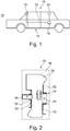
Die
Das Fahrunterstützungssystem
Das Fahrunterstützungssystem
Das Fahrunterstützungssystem
Fahrunterstützungssystem
Entsprechend ist das Fahrunterstützungssystem
Entsprechend ist die Zielposition
Das Verfahren beginnt mit Schritt S100, der ein Bereitstellen von Bildern der Umgebung
Schritt S110 betrifft ein Erzeugen eines Umgebungsbildes
In einer alternativen, vierten Ausführungsform, die in
In einer alternativen, fünften Ausführungsform, die in
Schritt S120 betrifft ein Empfangen von Sensorinformation des Umgebungssensors
Schritt S130 betrifft ein Bestimmen wenigstens einer Zielposition
Das Ermitteln des wenigstens einen Parkplatzes
Schritt S140 betrifft ein Darstellen der wenigstens einen Zielposition
Schritt S150 betrifft ein Ermitteln eines nicht befahrbaren Bereichs
Auch das Ermitteln des nicht befahrbaren Bereichs
Das Ermitteln des nicht befahrbaren Bereichs
Schritt S160 betrifft ein Darstellen des nicht befahrbaren Bereichs
In der vierten oder fünften Ausführungsform, die in den
Schritt S170 betrifft ein Ermitteln wenigstens eines Hindernisses
Auch das Ermitteln des wenigstens eines Hindernisses
Das Ermitteln des wenigstens eines Hindernisses
Schritt S180 betrifft ein Darstellen des wenigstens einen Hindernisses
In dem ersten Ausführungsbeispiel, das in
In dem zweiten Ausführungsbeispiel, das in
Basierend auf der Identifizierung wird eine Darstellung für das Hindernis
In dem dritten Ausführungsbeispiel, das in
Schritt S190 betrifft ein Überlagern des Umgebungsbildes
Durch das Überlagern des Umgebungsbildes
BezugszeichenlisteList of reference symbols
- 1010
- Fahrzeugvehicle
- 1212th
- FahrunterstützungssystemDriving assistance system
- 1414th
- kamerabasiertes Umgebungserfassungssystemcamera-based environment detection system
- 1616
- UmgebungSurroundings
- 1818th
- VerarbeitungseinheitProcessing unit
- 2020th
- DatenbusData bus
- 2222nd
- UmgebungssensorEnvironmental sensor
- 2424
- Zielposition, ParkplatzTarget position, parking lot
- 2626th
- UmgebungsbildEnvironment image
- 2828
- befahrbarer Bereichpassable area
- 3030th
- nicht befahrbarer Bereichnot passable area
- 3232
- Hindernisobstacle
ZITATE ENTHALTEN IN DER BESCHREIBUNGQUOTES INCLUDED IN THE DESCRIPTION
Diese Liste der vom Anmelder aufgeführten Dokumente wurde automatisiert erzeugt und ist ausschließlich zur besseren Information des Lesers aufgenommen. Die Liste ist nicht Bestandteil der deutschen Patent- bzw. Gebrauchsmusteranmeldung. Das DPMA übernimmt keinerlei Haftung für etwaige Fehler oder Auslassungen.This list of the documents listed by the applicant was generated automatically and is included solely for the better information of the reader. The list is not part of the German patent or utility model application. The DPMA assumes no liability for any errors or omissions.
Zitierte PatentliteraturPatent literature cited
- DE 10317044 A1 [0009]DE 10317044 A1 [0009]
- DE 102011082483 A1 [0010]DE 102011082483 A1 [0010]
- US 2015/0098623 A1 [0011]US 2015/0098623 A1 [0011]
Claims (16)
Priority Applications (5)
| Application Number | Priority Date | Filing Date | Title |
|---|---|---|---|
| DE102019123778.5A DE102019123778A1 (en) | 2019-09-05 | 2019-09-05 | Representing a vehicle environment for moving the vehicle to a target position |
| CN202080073890.2A CN114585540B (en) | 2019-09-05 | 2020-09-01 | Display of vehicle environment for moving vehicle to target location |
| US17/639,701 US20220297605A1 (en) | 2019-09-05 | 2020-09-01 | Display of a vehicle environment for moving the vehicle to a target position |
| EP20767744.4A EP4025460A1 (en) | 2019-09-05 | 2020-09-01 | Display of a vehicle environment for moving the vehicle to a target position |
| PCT/EP2020/074273 WO2021043732A1 (en) | 2019-09-05 | 2020-09-01 | Display of a vehicle environment for moving the vehicle to a target position |
Applications Claiming Priority (1)
| Application Number | Priority Date | Filing Date | Title |
|---|---|---|---|
| DE102019123778.5A DE102019123778A1 (en) | 2019-09-05 | 2019-09-05 | Representing a vehicle environment for moving the vehicle to a target position |
Publications (1)
| Publication Number | Publication Date |
|---|---|
| DE102019123778A1 true DE102019123778A1 (en) | 2021-03-11 |
Family
ID=72381056
Family Applications (1)
| Application Number | Title | Priority Date | Filing Date |
|---|---|---|---|
| DE102019123778.5A Pending DE102019123778A1 (en) | 2019-09-05 | 2019-09-05 | Representing a vehicle environment for moving the vehicle to a target position |
Country Status (5)
| Country | Link |
|---|---|
| US (1) | US20220297605A1 (en) |
| EP (1) | EP4025460A1 (en) |
| CN (1) | CN114585540B (en) |
| DE (1) | DE102019123778A1 (en) |
| WO (1) | WO2021043732A1 (en) |
Families Citing this family (3)
| Publication number | Priority date | Publication date | Assignee | Title |
|---|---|---|---|---|
| KR20220052172A (en) * | 2020-10-20 | 2022-04-27 | 현대모비스 주식회사 | Surround view monitoring system and providing method of the same |
| DE102022204313A1 (en) * | 2022-05-02 | 2023-11-02 | Volkswagen Aktiengesellschaft | Method and device for generating an image of the environment for a parking assistant of a vehicle |
| CN118135542B (en) * | 2024-05-06 | 2024-08-09 | 武汉未来幻影科技有限公司 | Obstacle dynamic and static state judging method and related equipment thereof |
Citations (4)
| Publication number | Priority date | Publication date | Assignee | Title |
|---|---|---|---|---|
| EP2207350A1 (en) * | 2007-10-01 | 2010-07-14 | Nissan Motor Co., Ltd. | Parking assistance device and parking assistance method |
| DE102010051204A1 (en) * | 2010-11-12 | 2012-05-16 | Valeo Schalter Und Sensoren Gmbh | Method for displaying obstacle for vehicle, involves detecting area surrounding vehicle with camera system, and detecting obstacles with sensor element independent of camera system |
| DE102011082483A1 (en) * | 2011-09-12 | 2013-03-14 | Robert Bosch Gmbh | Method for assisting a driver of a motor vehicle |
| DE102011084524A1 (en) * | 2011-10-14 | 2013-04-18 | Robert Bosch Gmbh | Method for displaying a vehicle environment |
Family Cites Families (26)
| Publication number | Priority date | Publication date | Assignee | Title |
|---|---|---|---|---|
| DE10317044A1 (en) * | 2003-04-11 | 2004-10-21 | Daimlerchrysler Ag | Optical monitoring system for use in maneuvering road vehicles provides virtual guide surfaces to ensure collision free movement |
| JP2006341641A (en) * | 2005-06-07 | 2006-12-21 | Nissan Motor Co Ltd | Image display apparatus and image display method |
| JP4321543B2 (en) * | 2006-04-12 | 2009-08-26 | トヨタ自動車株式会社 | Vehicle periphery monitoring device |
| DE102008003662A1 (en) * | 2008-01-09 | 2009-07-16 | Robert Bosch Gmbh | Method and device for displaying the environment of a vehicle |
| JP4661917B2 (en) * | 2008-07-25 | 2011-03-30 | 日産自動車株式会社 | Parking assistance device and parking assistance method |
| JP2011150475A (en) * | 2010-01-20 | 2011-08-04 | Toyota Motor Corp | Periphery monitor |
| US10703299B2 (en) * | 2010-04-19 | 2020-07-07 | SMR Patents S.à.r.l. | Rear view mirror simulation |
| DE102010051206A1 (en) * | 2010-11-12 | 2012-05-16 | Valeo Schalter Und Sensoren Gmbh | A method of generating an image of a vehicle environment and imaging device |
| JP5798392B2 (en) * | 2011-06-27 | 2015-10-21 | クラリオン株式会社 | Parking assistance device |
| DE102011084993A1 (en) * | 2011-10-21 | 2013-04-25 | Robert Bosch Gmbh | Transfer of data from image data-based map services to an assistance system |
| DE102011087901A1 (en) * | 2011-12-07 | 2013-06-13 | Robert Bosch Gmbh | Method for displaying a vehicle environment |
| US9886636B2 (en) * | 2013-05-23 | 2018-02-06 | GM Global Technology Operations LLC | Enhanced top-down view generation in a front curb viewing system |
| DE102014219575A1 (en) * | 2013-09-30 | 2015-07-23 | Honda Motor Co., Ltd. | Improved 3-dimensional (3-D) navigation |
| JP6149676B2 (en) | 2013-10-09 | 2017-06-21 | 富士通株式会社 | Image processing apparatus, image processing method, and program |
| US20150109444A1 (en) * | 2013-10-22 | 2015-04-23 | GM Global Technology Operations LLC | Vision-based object sensing and highlighting in vehicle image display systems |
| DE102014204872B4 (en) * | 2014-03-17 | 2018-03-22 | Volkswagen Aktiengesellschaft | A method and display system for displaying environmental information of a vehicle |
| US9892493B2 (en) * | 2014-04-21 | 2018-02-13 | Texas Instruments Incorporated | Method, apparatus and system for performing geometric calibration for surround view camera solution |
| JP6365238B2 (en) * | 2014-10-29 | 2018-08-01 | 株式会社デンソー | Parking assistance device |
| KR102499421B1 (en) * | 2016-05-05 | 2023-02-14 | 하만인터내셔날인더스트리스인코포레이티드 | Systems and methods for driver assistance |
| KR101832466B1 (en) * | 2016-06-14 | 2018-04-13 | 엘지전자 주식회사 | Parking Assistance Apparatus and Vehicle Having The Same |
| CN109691088B (en) * | 2016-08-22 | 2022-04-15 | 索尼公司 | Image processing apparatus, image processing method, and program |
| JP6757261B2 (en) * | 2017-01-13 | 2020-09-16 | クラリオン株式会社 | In-vehicle processing device |
| DE102017115810A1 (en) * | 2017-07-13 | 2019-01-17 | Valeo Schalter Und Sensoren Gmbh | Autonomous parking of a vehicle based on a passable area |
| CN110892464A (en) * | 2017-08-07 | 2020-03-17 | 日立汽车系统株式会社 | Parking control device and method |
| EP3576010A1 (en) * | 2018-05-31 | 2019-12-04 | KPIT Technologies Ltd. | System and method for detection of free parking space for a vehicle |
| US11760262B2 (en) * | 2019-11-19 | 2023-09-19 | Hyundai Mobis Co., Ltd. | Surround view monitoring system and method for vehicle, and parking assist control system of vehicle |
-
2019
- 2019-09-05 DE DE102019123778.5A patent/DE102019123778A1/en active Pending
-
2020
- 2020-09-01 WO PCT/EP2020/074273 patent/WO2021043732A1/en unknown
- 2020-09-01 EP EP20767744.4A patent/EP4025460A1/en active Pending
- 2020-09-01 CN CN202080073890.2A patent/CN114585540B/en active Active
- 2020-09-01 US US17/639,701 patent/US20220297605A1/en active Pending
Patent Citations (4)
| Publication number | Priority date | Publication date | Assignee | Title |
|---|---|---|---|---|
| EP2207350A1 (en) * | 2007-10-01 | 2010-07-14 | Nissan Motor Co., Ltd. | Parking assistance device and parking assistance method |
| DE102010051204A1 (en) * | 2010-11-12 | 2012-05-16 | Valeo Schalter Und Sensoren Gmbh | Method for displaying obstacle for vehicle, involves detecting area surrounding vehicle with camera system, and detecting obstacles with sensor element independent of camera system |
| DE102011082483A1 (en) * | 2011-09-12 | 2013-03-14 | Robert Bosch Gmbh | Method for assisting a driver of a motor vehicle |
| DE102011084524A1 (en) * | 2011-10-14 | 2013-04-18 | Robert Bosch Gmbh | Method for displaying a vehicle environment |
Also Published As
| Publication number | Publication date |
|---|---|
| US20220297605A1 (en) | 2022-09-22 |
| CN114585540A (en) | 2022-06-03 |
| EP4025460A1 (en) | 2022-07-13 |
| WO2021043732A1 (en) | 2021-03-11 |
| CN114585540B (en) | 2024-08-20 |
Similar Documents
| Publication | Publication Date | Title |
|---|---|---|
| WO2021043732A1 (en) | Display of a vehicle environment for moving the vehicle to a target position | |
| DE102017115810A1 (en) | Autonomous parking of a vehicle based on a passable area | |
| DE102008036009A1 (en) | Vehicle i.e. motor vehicle, protecting method for use in e.g. park garage, involves determining probability of collision of vehicle with objects provided in surrounding of vehicle from other objects by consideration of vehicle movement | |
| DE102008003662A1 (en) | Method and device for displaying the environment of a vehicle | |
| EP1147032A1 (en) | Device for monitoring the surrounding area of a vehicle during parking | |
| DE102015203016A1 (en) | Method and device for optical self-localization of a motor vehicle in an environment | |
| DE102015208590A1 (en) | DEVICE FOR DETERMINING A ROUGH FOR A VEHICLE, CORRESPONDING METHOD AND VEHICLE | |
| EP1874611A1 (en) | Method and device for evaluating distance measuring data of a distance measuring system of a motor vehicle | |
| DE102010063801A1 (en) | Method for assisting a driver of a motor vehicle | |
| DE102019126446A1 (en) | Vehicle control device | |
| EP2579228A1 (en) | Method and system for digital imaging of the vicinity of a vehicle | |
| DE102011084588B4 (en) | Method for assisting a driver in parking | |
| DE102006037600B4 (en) | Method for the resolution-dependent representation of the environment of a motor vehicle | |
| DE102013215408A1 (en) | A vehicle display system and method for displaying a vehicle environment | |
| DE102016122756A1 (en) | A method for assisting a driver of a motor vehicle when parking the motor vehicle on a parking area, driver assistance system and motor vehicle | |
| EP1724726B1 (en) | Method and apparatus for measuring a parking space with a single camera | |
| DE102019208507A1 (en) | Method for determining the degree of overlap between an object and a lane | |
| EP4237305A1 (en) | Method and control device for the situation-dependent determination of observation areas for motor vehicles operated in an at least partially autonomous manner | |
| WO2014202496A1 (en) | Method for displaying environment information in a vehicle | |
| DE102018107212A1 (en) | A method for detecting a traffic area occupancy detection auxiliary element in a surrounding area of a motor vehicle, computer program product and vehicle guidance system | |
| DE102022130172B4 (en) | Method and driver assistance system for supporting a driver when driving in a proximity area of a trajectory | |
| WO2024037815A1 (en) | Method for operating a display device in a motor vehicle | |
| DE102021211309A1 (en) | Method for generating a representation of a mobile platform environment | |
| DE102015121504A1 (en) | A method for detecting a longitudinal parking space for parking a motor vehicle based on a road marking, driver assistance system and motor vehicle | |
| DE102022205393A1 (en) | Method for operating an information system, computer program product and vehicle |
Legal Events
| Date | Code | Title | Description |
|---|---|---|---|
| R163 | Identified publications notified |