CN116228551A - Improved remote sensing lake surface temperature space-time filling method - Google Patents
Improved remote sensing lake surface temperature space-time filling method Download PDFInfo
- Publication number
- CN116228551A CN116228551A CN202211514326.7A CN202211514326A CN116228551A CN 116228551 A CN116228551 A CN 116228551A CN 202211514326 A CN202211514326 A CN 202211514326A CN 116228551 A CN116228551 A CN 116228551A
- Authority
- CN
- China
- Prior art keywords
- data
- lswt
- lake
- surface temperature
- filling
- Prior art date
- Legal status (The legal status is an assumption and is not a legal conclusion. Google has not performed a legal analysis and makes no representation as to the accuracy of the status listed.)
- Granted
Links
Images

Classifications
-
- G—PHYSICS
- G06—COMPUTING OR CALCULATING; COUNTING
- G06T—IMAGE DATA PROCESSING OR GENERATION, IN GENERAL
- G06T5/00—Image enhancement or restoration
- G06T5/77—Retouching; Inpainting; Scratch removal
-
- G—PHYSICS
- G06—COMPUTING OR CALCULATING; COUNTING
- G06T—IMAGE DATA PROCESSING OR GENERATION, IN GENERAL
- G06T3/00—Geometric image transformations in the plane of the image
- G06T3/40—Scaling of whole images or parts thereof, e.g. expanding or contracting
- G06T3/4007—Scaling of whole images or parts thereof, e.g. expanding or contracting based on interpolation, e.g. bilinear interpolation
-
- G—PHYSICS
- G06—COMPUTING OR CALCULATING; COUNTING
- G06V—IMAGE OR VIDEO RECOGNITION OR UNDERSTANDING
- G06V10/00—Arrangements for image or video recognition or understanding
- G06V10/70—Arrangements for image or video recognition or understanding using pattern recognition or machine learning
- G06V10/764—Arrangements for image or video recognition or understanding using pattern recognition or machine learning using classification, e.g. of video objects
-
- G—PHYSICS
- G06—COMPUTING OR CALCULATING; COUNTING
- G06V—IMAGE OR VIDEO RECOGNITION OR UNDERSTANDING
- G06V10/00—Arrangements for image or video recognition or understanding
- G06V10/70—Arrangements for image or video recognition or understanding using pattern recognition or machine learning
- G06V10/77—Processing image or video features in feature spaces; using data integration or data reduction, e.g. principal component analysis [PCA] or independent component analysis [ICA] or self-organising maps [SOM]; Blind source separation
- G06V10/774—Generating sets of training patterns; Bootstrap methods, e.g. bagging or boosting
-
- G—PHYSICS
- G06—COMPUTING OR CALCULATING; COUNTING
- G06T—IMAGE DATA PROCESSING OR GENERATION, IN GENERAL
- G06T2207/00—Indexing scheme for image analysis or image enhancement
- G06T2207/10—Image acquisition modality
- G06T2207/10032—Satellite or aerial image; Remote sensing
-
- G—PHYSICS
- G06—COMPUTING OR CALCULATING; COUNTING
- G06T—IMAGE DATA PROCESSING OR GENERATION, IN GENERAL
- G06T2207/00—Indexing scheme for image analysis or image enhancement
- G06T2207/30—Subject of image; Context of image processing
- G06T2207/30168—Image quality inspection
-
- Y—GENERAL TAGGING OF NEW TECHNOLOGICAL DEVELOPMENTS; GENERAL TAGGING OF CROSS-SECTIONAL TECHNOLOGIES SPANNING OVER SEVERAL SECTIONS OF THE IPC; TECHNICAL SUBJECTS COVERED BY FORMER USPC CROSS-REFERENCE ART COLLECTIONS [XRACs] AND DIGESTS
- Y02—TECHNOLOGIES OR APPLICATIONS FOR MITIGATION OR ADAPTATION AGAINST CLIMATE CHANGE
- Y02A—TECHNOLOGIES FOR ADAPTATION TO CLIMATE CHANGE
- Y02A90/00—Technologies having an indirect contribution to adaptation to climate change
- Y02A90/30—Assessment of water resources
Landscapes
- Engineering & Computer Science (AREA)
- Theoretical Computer Science (AREA)
- General Physics & Mathematics (AREA)
- Physics & Mathematics (AREA)
- Computing Systems (AREA)
- Databases & Information Systems (AREA)
- Evolutionary Computation (AREA)
- General Health & Medical Sciences (AREA)
- Medical Informatics (AREA)
- Software Systems (AREA)
- Health & Medical Sciences (AREA)
- Computer Vision & Pattern Recognition (AREA)
- Artificial Intelligence (AREA)
- Multimedia (AREA)
- Image Processing (AREA)
- Radiation Pyrometers (AREA)
Abstract
Description
技术领域technical field
本发明涉及遥感科学技术领域,特别涉及一种改进的遥感湖泊表面温度时空填补方法。The invention relates to the field of remote sensing science and technology, in particular to an improved space-time filling method for remote sensing lake surface temperature.
背景技术Background technique
湖泊对水循环和生态平衡至关重要(Verpoorter et al., 2014)。湖泊表面温度(LSWT)是理解气候变化和能量交换对湖泊影响的一个重要物理变量(Doney et al.,2012;Pachauriet al., 2014)。它可以灵敏地检测湖泊环境特征和反应过程、生物多样性和水动力学的变化(Yang et al., 2019)。已有研究显示,全球大型湖泊普遍表现出显著变暖的趋势(O'Reilly et al., 2015)。Lakes are crucial to the water cycle and ecological balance (Verpoorter et al., 2014). Lake surface temperature (LSWT) is an important physical variable for understanding the impact of climate change and energy exchange on lakes (Doney et al., 2012; Pachauri et al., 2014). It can sensitively detect changes in lake environmental characteristics and response processes, biodiversity, and hydrodynamics (Yang et al., 2019). Studies have shown that large lakes around the world generally show a significant warming trend (O'Reilly et al., 2015).
早期监测LSWT的传统方法是使用现场传感器测量特定站点的温度(Ptak et al.,2019)。然而,尽管该方法精度高、操作灵活,但其存在各种局限性,如人力物力成本高、时间和空间分辨率低(Kumari et al., 2018)。遥感是克服这些困难和获得更全面的温度信息的有效方法(Hong et al., 2021)。近年来,用于地表温度反演的卫星数据主要包括微波和热红外(TIR)两种类型。由于TIR数据的多样性,这种遥感方法被广泛应用于温度监测。TIR数据包括高分辨率辐射计(AVHRR)、沿轨扫描辐射计(ATSR)、陆地卫星和中分辨率成像光谱仪(MODIS)。其中,MODIS地表温度产品是较为常用的数据集。它具有相对较高的时间和空间分辨率、较宽的光谱范围、较高的辐射灵敏度和合适的TIR通道设置。在以往的研究中,MODIS陆地表面温度(LST)数据集被广泛用于监测陆地和水面温度(Hu et al., 2020)。然而,由于云效应和其他大气干扰,MODIS LST产品有大面积的缺失或“噪声”像元,导致时空信息空缺严重,进而限制了湖泊表面温度的长期监测。为此,研究人员提出了一系列MODISLST产品重构方法,以填补缺失数据,提高遥感数据的有效性。The traditional method for early monitoring of LSWT is to use site sensors to measure the temperature at specific sites (Ptak et al., 2019). However, despite the high precision and flexible operation of this method, it has various limitations, such as high manpower and material costs, and low temporal and spatial resolution (Kumari et al., 2018). Remote sensing is an effective way to overcome these difficulties and obtain more comprehensive temperature information (Hong et al., 2021). In recent years, satellite data used for surface temperature retrieval mainly include two types: microwave and thermal infrared (TIR). Due to the diversity of TIR data, this remote sensing method is widely used in temperature monitoring. TIR data includes High Resolution Radiometer (AVHRR), Along-orbit Scanning Radiometer (ATSR), Landsat and Moderate Resolution Imaging Spectroradiometer (MODIS). Among them, MODIS surface temperature products are more commonly used data sets. It has relatively high temporal and spatial resolution, wide spectral range, high radiation sensitivity and suitable TIR channel settings. In previous studies, the MODIS Land Surface Temperature (LST) dataset was widely used to monitor land and water surface temperatures (Hu et al., 2020). However, MODIS LST products have large areas of missing or "noisy" pixels due to cloud effects and other atmospheric disturbances, resulting in severe spatiotemporal information gaps, which in turn limit long-term monitoring of lake surface temperatures. To this end, the researchers proposed a series of MODISLST product reconstruction methods to fill in missing data and improve the validity of remote sensing data.
现有的LSWT间隙填充方法多与LST方法相似,一般通过多个卫星产品的数据融合或添加相应的辅助数据集和外部环境因素来实现LSWT的预测(Layden et al., 2016)。这些方法依靠与LST或LSWT密切相关的外部环境因素,如气象变量(如温度和降水)和数字高程模型,来预测缺失的像元。然而,在缺乏辅助数据集的情况下,重构的LSWT精度可能会显著下降。这些条件使填充方法变得复杂,并在一定程度上限制了它们的应用,特别是对于可用辅助数据有限的湖泊。Most of the existing LSWT gap filling methods are similar to the LST method. Generally, the prediction of LSWT is realized by data fusion of multiple satellite products or by adding corresponding auxiliary data sets and external environmental factors (Layden et al., 2016). These methods rely on external environmental factors closely related to LST or LSWT, such as meteorological variables (such as temperature and precipitation) and digital elevation models, to predict missing pixels. However, in the absence of auxiliary datasets, the reconstructed LSWT accuracy may drop significantly. These conditions complicate filling methods and somewhat limit their application, especially for lakes with limited auxiliary data available.
综上所述,现有的湖泊温度数据获取,往往地表温度产品空缺严重、现有方法在填补LSWT产品时空空白方面仍存在障碍,而无法获得完整的长时序湖泊温度数据。在此背景下,开展湖泊温度时空间隙填充方法的研究,可为水文环境变化相关科学问题的探索提供重要的数据保障和方法支撑,具有重要的科学意义。To sum up, the existing lake temperature data acquisition often has serious gaps in surface temperature products, and existing methods still have obstacles in filling the space-time gaps in LSWT products, making it impossible to obtain complete long-term lake temperature data. In this context, it is of great scientific significance to carry out the research on the filling method of lake temperature space-time gap, which can provide important data guarantee and method support for the exploration of scientific issues related to hydrological environment change.
发明内容Contents of the invention
为填补基于遥感的地表温度原始影像的时空间隙,实现对湖泊表面温度的长期监测。本发明提出一种在空间域上采用基于离散余弦变换的惩罚最小二乘法(DCT-PLS)与在时间域上采用的线性插值(LI)算法相结合的改进的间隙填补方法,采用可公开免费获取的MODIS遥感影像数据以及Yearly Water Classification History数据集,借助时空域填充相结合的方法,实现了长时序湖泊表面温度信息的重建。In order to fill the space-time gap of the original image of surface temperature based on remote sensing, the long-term monitoring of lake surface temperature is realized. The present invention proposes an improved gap filling method that combines the discrete cosine transform-based penalized least squares method (DCT-PLS) in the space domain and the linear interpolation (LI) algorithm in the time domain. The obtained MODIS remote sensing image data and the Yearly Water Classification History dataset, with the help of the method of combining time and space domain filling, realized the reconstruction of long-term lake surface temperature information.
为实现上述技术目的,本发明采用如下技术方案:In order to realize the above-mentioned technical purpose, the present invention adopts following technical scheme:
一种改进的遥感湖泊表面温度时空填补方法,包括:An improved space-time filling method for remote sensing lake surface temperature, including:
获取遥感反演地表温度数据,对湖泊永久水域边界向内做缓冲区以提取湖泊表面温度LSWT数据;Obtain the surface temperature data retrieved from remote sensing, and make a buffer zone inwards for the permanent water boundary of the lake to extract the LSWT data of the lake surface temperature;
基于有效像元数将LSWT数据划分为高质量影像和低质量影像;Divide LSWT data into high-quality images and low-quality images based on the effective number of pixels;
利用DCT-PLS方法填充高质量影像;Use the DCT-PLS method to fill high-quality images;
构建每隔n天的LSWT的距平值作为背景场,与低质量影像的对应日期的LSWT中值叠加后,得到空间填充的低质量影像,之后对填充的所有影像的时间序列进行插值,从而完成所有影像数据的时空填补。The anomaly value of LSWT every n days is constructed as the background field, and after being superimposed with the median value of LSWT of the corresponding date of the low-quality image, a space-filled low-quality image is obtained, and then the time series of all the filled images are interpolated, so that Complete the space-time filling of all image data.
作为一种优选的实施方式,所述方法还包括,利用质量控制QC控制地表温度数据质量,基于通过质量控制的像元提取LSWT数据。As a preferred implementation manner, the method further includes, using quality control QC to control the quality of the surface temperature data, and extracting LSWT data based on pixels that pass the quality control.
作为一种优选的实施方式,比较湖泊多年的水域边界,选取多年最小的永久水体的水域边界作为湖泊永久水域边界。As a preferred implementation manner, the water boundary of the lake for many years is compared, and the water boundary of the permanent water body with the smallest number of years is selected as the permanent water boundary of the lake.
作为一种优选的实施方式,所述方法还包括,对提取的LSWT数据,采用随机消隐的方法选择验证数据集,用于数据验证。As a preferred implementation manner, the method further includes, for the extracted LSWT data, selecting a verification data set by random blanking for data verification.
作为一种优选的实施方式,在每个LSWT影像上随机选取若干像元,将对应的原始温度值替换为空值,对替换空值后的LSWT数据进行填充,并利用所述若干像元验证填补准确性。As a preferred implementation, randomly select several pixels on each LSWT image, replace the corresponding original temperature value with a null value, fill the LSWT data after replacing the null value, and use the several pixels to verify fill accuracy.
作为一种优选的实施方式,预设有效像元数阈值,有效像元数高于阈值的影像为高质量影像,低于阈值的影像为低质量影像。As a preferred implementation manner, a threshold value of the number of effective pixels is preset, an image with an effective number of pixels higher than the threshold is a high-quality image, and an image lower than the threshold is a low-quality image.
作为一种优选的实施方式,采用线性插值方法对填充后的所有影像的时间序列进行插值。As a preferred implementation manner, a linear interpolation method is used to interpolate the time series of all filled images.
作为一种优选的实施方式,在完成所有影像数据的时空填补后,通过R2、MAE、MSE和RMSE 4个误差指标评价LSWT数据填充的准确性。As a preferred implementation, after completing the space-time filling of all image data, the accuracy of LSWT data filling is evaluated by four error indicators: R 2 , MAE, MSE and RMSE.
作为一种优选的实施方式,所述遥感反演地表温度数据选用MOD11A2地表温度数据产品。As a preferred implementation, the remote sensing retrieved surface temperature data is selected from the MOD11A2 surface temperature data product.
作为一种优选的实施方式,基于Yearly Water Classification History数据集获取湖泊多年的水域边界数据。As a preferred implementation, the water boundary data of the lake for many years is obtained based on the Yearly Water Classification History dataset.
本发明具有以下两点优势:The present invention has following two advantages:
(1)本发明对数据的要求较低,基于可公开获取的遥感影像数据和地表水体数据,不依赖于其他湖泊环境要素,即可完成湖泊表面温度时空间隙的填充,进而构建长时序湖泊温度数据。(1) The present invention has relatively low data requirements. Based on publicly available remote sensing image data and surface water body data, it can complete the filling of the temporal and spatial gaps of lake surface temperature without relying on other lake environmental elements, and then construct a long-term lake temperature data.
(2)本发明提出了一种改进的湖泊表面温度(LSWT)时空间隙填充方法,不仅不局限于研究区域、湖泊面积的大小,还可以在长时序、多时间尺度上开展湖泊温度变化分析,为进一步了解湖泊水文环境变化对全球气候变化的响应提供了重要的基础数据和技术支撑。(2) This invention proposes an improved lake surface temperature (LSWT) space-time gap filling method, which is not limited to the size of the research area and lake area, but can also carry out analysis of lake temperature changes on long-term and multi-time scales. It provides important basic data and technical support for further understanding the response of lake hydrological environment changes to global climate change.
附图说明Description of drawings
附图不意在按比例绘制。在附图中,在各个图中示出的每个相同或近似相同的组成部分可以用相同的标号表示。为了清晰起见,在每个图中,并非每个组成部分均被标记。现在,将通过研究案例并参考附图来描述本发明的各个步骤,其中:The figures are not intended to be drawn to scale. In the drawings, each identical or nearly identical component that is illustrated in various figures may be represented by a like reference numeral. For purposes of clarity, not every component may be labeled in every drawing. The various steps of the invention will now be described by studying a case and with reference to the accompanying drawings, in which:
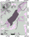
图1是本发明实施例1呼伦湖及周边地形图。Figure 1 is a topographic map of Hulun Lake and its surroundings in
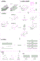
图2是本发明方法流程图。Fig. 2 is a flow chart of the method of the present invention.
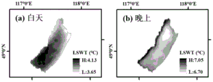
图3是实施例1中基于DCT-PLS方法空间填充后的呼伦湖多年平均LSWT影像:(a)白天;(b)晚上。Figure 3 is the multi-year average LSWT image of Hulun Lake after space filling based on the DCT-PLS method in Example 1: (a) during the day; (b) at night.
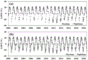
图4是实施例1中采用线性插值方法前后的呼伦湖8天尺度的LSWT时间序列。Figure 4 is the 8-day LSWT time series of Hulun Lake before and after using the linear interpolation method in Example 1.
图5是实施例1呼伦湖湖泊温度时间序列线性插值结果精度评价。Fig. 5 is the accuracy evaluation of the linear interpolation results of the temperature time series of Hulun Lake in Example 1.
图6是实施例1呼伦湖湖泊温度空间填充结果精度评价。Fig. 6 is the accuracy evaluation of the temperature space filling results of Hulun Lake in Example 1.
具体实施方式Detailed ways
下面结合附图和实施例1,对本发明的具体实施方式作进一步详细描述。以下实施案例用于说明本发明,但不用来限制本发明的范围。The specific implementation manner of the present invention will be further described in detail below in conjunction with the accompanying drawings and
本申请的实施例1以内蒙古高原最大的湖泊呼伦湖为研究对象。内蒙古高原范围广、海拔高,其周边地区通过独特的大气相互作用在全球气候变化中发挥着重要作用。内蒙古高原具有典型的温带大陆性气候,区域平均温度差异很大。内蒙古高原有许多大湖,大多分布在西北部。这些湖泊在水、冰冻圈和能量循环中发挥着重要作用。呼伦湖作为中国第四大淡水湖,内蒙古高原第一大湖泊,其对于气候变化的响应十分强烈,比较适合作为研究对象。
如图2所示,是实施例1的流程图,本实施例1包括以下步骤:As shown in Figure 2, it is the flow chart of
步骤1、获取遥感影像数据,并对MODIS遥感影像数据进行预处理。首先从EARTHDATA(https://modis.ornl.gov/globalsubset/)数据网站下载2000年以来覆盖呼伦湖的所有MODIS LST遥感影像,包括Day和Night两套数据。MODIS地表温度数据的预处理选用MOD11A2地表温度数据产品中的质量控制QC和地表温度LST两个数据层。利用质量控制数据QC来控制MODIS地表温度的质量,并保留较好的质量像元(QC值为1的像元)。比较湖泊多年的水域边界,选取多年最小的永久水体作为最终边界,并向内做缓冲区来提取呼伦湖湖泊LSWT数据,对于面积大于50 km2的湖泊,设置内部缓冲区1000 m,小于50 km2的湖泊设置内部缓冲区500 m,湖泊的永久水域边界源于Yearly Water Classification History数据集。
步骤2、构建验证数据集,并评估空间填充LSWT的精度。Step 2. Build a validation dataset and evaluate the accuracy of the space-filling LSWT.
本实施例采用“随机消隐”方法选择验证数据集,用于评估填充LSWT的准确性;In this embodiment, the "random blanking" method is used to select a verification data set for evaluating the accuracy of filling the LSWT;
具体的,分别在步骤1提取的LSWT数据空间影像和时间序列上随机抽样10%的像元,并将对应的原始LSWT值假设为空值,将这些像元作为验证数据集。Specifically, 10% of the pixels are randomly sampled on the LSWT data space image and time series extracted in
步骤3、这一步骤是LSWT间隙填充过程的核心。它涉及基于DCT-PLS模型填充质量相对较好的影像,进而构建背景场来填充质量相对较差的影像。Step 3. This step is the core of the LSWT gap filling process. It involves filling relatively good-quality images based on the DCT-PLS model, and then constructing a background field to fill relatively poor-quality images.
(1)影像分类:首先根据有效像元数将影像(部分像元值设为空值后的原始LSWT数据)分为高质量影像和低质量影像。本实施例中设置有效像元数阈值为30%,即有效像元大于30%的影像为高质量影像,反之为低质量影像。(1) Image classification: First, the image (the original LSWT data after some pixel values are set to null values) is divided into high-quality images and low-quality images according to the number of effective pixels. In this embodiment, the threshold for the number of effective pixels is set to 30%, that is, an image with more than 30% effective pixels is a high-quality image, otherwise it is a low-quality image.
(2)DCT-PLS模型的应用:利用DCT-PLS方法填充高质量影像。(2) Application of DCT-PLS model: use DCT-PLS method to fill high-quality images.
(3)LSWT影像背景场的构建:基于高质量的填充影像,构建多时相平均LSWT背景场,辅助低质量影像的填充。假设大多数湖泊在不同季节或不同日期有一定的空间变化规律。因此,在已有LSWT完整影像的基础上,构建每隔8天LSWT的距平值作为背景场,加上对应低质量影像的LSWT中值则得到填充的低质量LSWT影像。如图3所示,呼伦湖的白天LSWT均显示从湖岸到湖心的温度逐渐降低(图3a)。白天和夜间LSWT变化趋势相反。在夜间,呼伦湖从湖岸到湖心呈现出变暖的趋势(图3b)。(3) Construction of the background field of the LSWT image: Based on the high-quality filling image, the multi-temporal average LSWT background field is constructed to assist the filling of the low-quality image. It is assumed that most lakes have certain spatial variation patterns in different seasons or on different days. Therefore, on the basis of the existing LSWT complete image, the anomaly value of LSWT every 8 days was constructed as the background field, and the LSWT median value corresponding to the low-quality image was added to obtain the filled low-quality LSWT image. As shown in Fig. 3, the daytime LSWT of Hulun Lake all showed a gradual decrease in temperature from the lake shore to the lake center (Fig. 3a). The changing trend of LSWT during the day and night was opposite. At night, Hulun Lake showed a warming trend from the shore to the center of the lake (Fig. 3b).
步骤4、由于在冬季影像缺失验证,所以在空间填充后,呼伦湖LSWT在时间序列中仍存在缺失。该方法进一步采用线性插值方法对LSWT数据的时间序列缺口进行了填补。图4a和图4b分别显示了采用线性插值方法前后的呼伦湖8天尺度的LSWT时间序列。Step 4. Due to the missing verification of winter images, after space filling, Hulun Lake LSWT is still missing in the time series. This method further uses the linear interpolation method to fill in the gaps in the time series of LSWT data. Figure 4a and Figure 4b show the 8-day LSWT time series of Hulun Lake before and after using the linear interpolation method.
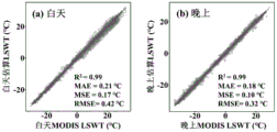
步骤5、时空LSWT填充结果评价。基于模拟缺失数据和相应的原始LSWT,通过R2、MAE、MSE和RMSE 4个误差指标评价呼伦湖LSWT数据时空填充的准确性。对于湖泊温度的时空填充结果(图5),呼伦湖白天和晚上重建的LSWT与实测LSWT值较为吻合,R2、MAE、MSE、RMSE分别为0.99、0.21 ℃、0.17 ℃、0.42 ℃和0.99、0.18 ℃、0.10 ℃、0.32 ℃。结合图4和图5,可以看出湖泊温度时间序列线性插值的效果也很好。Step 5. Evaluation of spatio-temporal LSWT filling results. Based on the simulated missing data and the corresponding original LSWT, the accuracy of spatiotemporal filling of Hulun Lake LSWT data was evaluated by four error indicators: R 2 , MAE, MSE and RMSE. For the spatio-temporal filling results of lake temperature (Figure 5), the LSWT reconstructed by Hulun Lake during the day and night is in good agreement with the measured LSWT value, and R 2 , MAE, MSE, RMSE are 0.99, 0.21 ℃, 0.17 ℃, 0.42 ℃ and 0.99 respectively , 0.18°C, 0.10°C, 0.32°C. Combining Figure 4 and Figure 5, it can be seen that the effect of linear interpolation of the lake temperature time series is also very good.
通过上述方法即可得到呼伦湖长时序湖泊温度,不仅不局限于研究区域、湖泊范围的大小,还可以在长时序、多时间尺度上开展湖泊温度变化分析,为进一步了解湖泊水文环境变化对全球气候变化的响应提供了重要的基础数据和技术支撑。The long-term lake temperature of Hulun Lake can be obtained by the above method, which is not limited to the size of the research area and lake range, but also can carry out the analysis of lake temperature changes on long-term and multi-time scales. In order to further understand the impact of lake hydrological environment changes on The response to global climate change provides important basic data and technical support.
Claims (10)
Applications Claiming Priority (2)
| Application Number | Priority Date | Filing Date | Title |
|---|---|---|---|
| CN202211297169 | 2022-10-21 | ||
| CN2022112971699 | 2022-10-21 |
Publications (2)
| Publication Number | Publication Date |
|---|---|
| CN116228551A true CN116228551A (en) | 2023-06-06 |
| CN116228551B CN116228551B (en) | 2025-06-27 |
Family
ID=86573724
Family Applications (1)
| Application Number | Title | Priority Date | Filing Date |
|---|---|---|---|
| CN202211514326.7A Active CN116228551B (en) | 2022-10-21 | 2022-11-30 | Improved remote sensing lake surface temperature space-time filling method |
Country Status (1)
| Country | Link |
|---|---|
| CN (1) | CN116228551B (en) |
Cited By (3)
| Publication number | Priority date | Publication date | Assignee | Title |
|---|---|---|---|---|
| CN117475324A (en) * | 2023-11-16 | 2024-01-30 | 中国科学院东北地理与农业生态研究所 | Lake ice phenology information extraction method based on lake surface temperature time series |
| CN117539855A (en) * | 2023-11-16 | 2024-02-09 | 中国科学院东北地理与农业生态研究所 | Method for extracting lake surface temperature using MODIS |
| CN120047839A (en) * | 2025-01-24 | 2025-05-27 | 中国科学院东北地理与农业生态研究所 | Lake ice weather information automatic extraction method based on ice water pixel proportion |
Citations (5)
| Publication number | Priority date | Publication date | Assignee | Title |
|---|---|---|---|---|
| JP2001111959A (en) * | 1999-10-04 | 2001-04-20 | Hitachi Ltd | Monitoring system |
| CN103399322A (en) * | 2013-08-02 | 2013-11-20 | 中国科学院寒区旱区环境与工程研究所 | MODIS (Moderate Resolution Imaging Spectroradiometer) land surface temperature-based permafrost figure automatic updating method |
| CN107655574A (en) * | 2017-08-23 | 2018-02-02 | 中国科学院光电研究院 | The method and system of sequential thermal infrared remote sensing surface temperature/emissivity Simultaneous Inversion |
| KR20200059085A (en) * | 2018-11-20 | 2020-05-28 | 서울대학교산학협력단 | A Method for Sea Surface Temperature Retrieval using Surface Drifter Temperature Data and Satellite Infrared Images |
| CN113313194A (en) * | 2021-06-17 | 2021-08-27 | 西北工业大学 | Propellant preparation data missing value filling method based on linear interpolation deviation |
-
2022
- 2022-11-30 CN CN202211514326.7A patent/CN116228551B/en active Active
Patent Citations (5)
| Publication number | Priority date | Publication date | Assignee | Title |
|---|---|---|---|---|
| JP2001111959A (en) * | 1999-10-04 | 2001-04-20 | Hitachi Ltd | Monitoring system |
| CN103399322A (en) * | 2013-08-02 | 2013-11-20 | 中国科学院寒区旱区环境与工程研究所 | MODIS (Moderate Resolution Imaging Spectroradiometer) land surface temperature-based permafrost figure automatic updating method |
| CN107655574A (en) * | 2017-08-23 | 2018-02-02 | 中国科学院光电研究院 | The method and system of sequential thermal infrared remote sensing surface temperature/emissivity Simultaneous Inversion |
| KR20200059085A (en) * | 2018-11-20 | 2020-05-28 | 서울대학교산학협력단 | A Method for Sea Surface Temperature Retrieval using Surface Drifter Temperature Data and Satellite Infrared Images |
| CN113313194A (en) * | 2021-06-17 | 2021-08-27 | 西北工业大学 | Propellant preparation data missing value filling method based on linear interpolation deviation |
Non-Patent Citations (2)
| Title |
|---|
| 刘恒孜,吕宁,姜侯,姚凌: "基于DCT-PLS算法的MODIS LST缺值填补方法研究", 地球信息科学学报, vol. 24, no. 2, 25 February 2022 (2022-02-25) * |
| 张桂欣;郝振纯;祝善友;周楚炫;华俊玮;: "AMSR2缺失数据重建及其土壤湿度反演精度评价", 农业工程学报, no. 20, 23 October 2016 (2016-10-23) * |
Cited By (5)
| Publication number | Priority date | Publication date | Assignee | Title |
|---|---|---|---|---|
| CN117475324A (en) * | 2023-11-16 | 2024-01-30 | 中国科学院东北地理与农业生态研究所 | Lake ice phenology information extraction method based on lake surface temperature time series |
| CN117539855A (en) * | 2023-11-16 | 2024-02-09 | 中国科学院东北地理与农业生态研究所 | Method for extracting lake surface temperature using MODIS |
| CN117539855B (en) * | 2023-11-16 | 2024-06-11 | 中国科学院东北地理与农业生态研究所 | Method for extracting lake surface temperature using MODIS |
| CN117475324B (en) * | 2023-11-16 | 2024-09-13 | 中国科学院东北地理与农业生态研究所 | Lake ice weather information extraction method based on lake surface temperature time sequence |
| CN120047839A (en) * | 2025-01-24 | 2025-05-27 | 中国科学院东北地理与农业生态研究所 | Lake ice weather information automatic extraction method based on ice water pixel proportion |
Also Published As
| Publication number | Publication date |
|---|---|
| CN116228551B (en) | 2025-06-27 |
Similar Documents
| Publication | Publication Date | Title |
|---|---|---|
| CN116228551A (en) | Improved remote sensing lake surface temperature space-time filling method | |
| CN116011342B (en) | A high-resolution thermal infrared surface temperature all-weather reconstruction method | |
| Li et al. | Spatio-temporal fusion for remote sensing data: An overview and new benchmark | |
| CN102096825B (en) | Graph-based semi-supervised high-spectral remote sensing image classification method | |
| Huang et al. | A novel fusion method for generating surface soil moisture data with high accuracy, high spatial resolution, and high spatio‐temporal continuity | |
| CN107818555B (en) | Multi-dictionary remote sensing image space-time fusion method based on maximum posterior | |
| Liang et al. | Maximum likelihood classification of soil remote sensing image based on deep learning | |
| CN105046648A (en) | Method for constructing high temporal-spatial remote sensing data | |
| CN103500449B (en) | Visible remote sensing image cloud detection method of optic on a kind of star | |
| CN107507152A (en) | A kind of remote sensing images missing data restorative procedure based on more image local interpolation | |
| Liu et al. | PSTAF-GAN: Progressive spatio-temporal attention fusion method based on generative adversarial network | |
| CN114862871B (en) | A method for extracting wheat planting areas from remote sensing images based on SE-UNet deep learning network | |
| CN103729653B (en) | A kind of method of high-resolution remote sensing image supervision change-detection | |
| Zhang et al. | A novel winter wheat yield prediction framework using fused spatial–temporal-spectral (STS) information from Sentinel-2 and Landsat 8 via improved Pix2Pix network | |
| CN112285808B (en) | A downscaling method for APHRODITE precipitation data | |
| CN114359724B (en) | A method for extracting earthquake damage information from remotely sensed buildings based on color-parameter migration | |
| Tang et al. | Filling then spatio-temporal fusion for all-sky MODIS land surface temperature generation | |
| CN103400022A (en) | Method for reconstituting sea surface temperature remote sensing dataset in same latitude | |
| Liu et al. | Bi-LSTM model for time series leaf area index estimation using multiple satellite products | |
| CN113779863B (en) | Ground surface temperature downscaling method based on data mining | |
| CN109671038A (en) | One kind is based on the classified and layered relative radiometric correction method of pseudo- invariant features point | |
| CN107576399B (en) | Brightness temperature prediction method and system for MODIS forest fire detection | |
| CN113378664A (en) | Hyperspectral image change detection method and system based on semi-nonnegative matrix factorization | |
| CN116068511B (en) | A large-scale system error correction method for InSAR based on deep learning | |
| CN104156923B (en) | Multispectral remote sensing image cloud removing method based on sparse representation |
Legal Events
| Date | Code | Title | Description |
|---|---|---|---|
| PB01 | Publication | ||
| PB01 | Publication | ||
| SE01 | Entry into force of request for substantive examination | ||
| SE01 | Entry into force of request for substantive examination | ||
| GR01 | Patent grant | ||
| GR01 | Patent grant |