CN112417078B - Space point aggregation method for aviation geophysical mapping data - Google Patents
Space point aggregation method for aviation geophysical mapping data Download PDFInfo
- Publication number
- CN112417078B CN112417078B CN202011375697.2A CN202011375697A CN112417078B CN 112417078 B CN112417078 B CN 112417078B CN 202011375697 A CN202011375697 A CN 202011375697A CN 112417078 B CN112417078 B CN 112417078B
- Authority
- CN
- China
- Prior art keywords
- point
- clustering
- data
- matrix
- degree
- Prior art date
- Legal status (The legal status is an assumption and is not a legal conclusion. Google has not performed a legal analysis and makes no representation as to the accuracy of the status listed.)
- Active
Links
Images


Classifications
-
- G—PHYSICS
- G06—COMPUTING; CALCULATING OR COUNTING
- G06F—ELECTRIC DIGITAL DATA PROCESSING
- G06F16/00—Information retrieval; Database structures therefor; File system structures therefor
- G06F16/20—Information retrieval; Database structures therefor; File system structures therefor of structured data, e.g. relational data
- G06F16/29—Geographical information databases
-
- G—PHYSICS
- G06—COMPUTING; CALCULATING OR COUNTING
- G06F—ELECTRIC DIGITAL DATA PROCESSING
- G06F16/00—Information retrieval; Database structures therefor; File system structures therefor
- G06F16/20—Information retrieval; Database structures therefor; File system structures therefor of structured data, e.g. relational data
- G06F16/28—Databases characterised by their database models, e.g. relational or object models
- G06F16/284—Relational databases
- G06F16/285—Clustering or classification
-
- G—PHYSICS
- G06—COMPUTING; CALCULATING OR COUNTING
- G06F—ELECTRIC DIGITAL DATA PROCESSING
- G06F17/00—Digital computing or data processing equipment or methods, specially adapted for specific functions
- G06F17/10—Complex mathematical operations
- G06F17/16—Matrix or vector computation, e.g. matrix-matrix or matrix-vector multiplication, matrix factorization
Landscapes
- Engineering & Computer Science (AREA)
- Physics & Mathematics (AREA)
- Theoretical Computer Science (AREA)
- Databases & Information Systems (AREA)
- General Physics & Mathematics (AREA)
- Data Mining & Analysis (AREA)
- General Engineering & Computer Science (AREA)
- Mathematical Physics (AREA)
- Pure & Applied Mathematics (AREA)
- Mathematical Optimization (AREA)
- Mathematical Analysis (AREA)
- Computational Mathematics (AREA)
- Algebra (AREA)
- Software Systems (AREA)
- Computing Systems (AREA)
- Remote Sensing (AREA)
- Information Retrieval, Db Structures And Fs Structures Therefor (AREA)
Abstract
The invention provides a method for aggregating spatial points of aviation geophysical mapping data, which comprises the steps of dividing data of an extracted target point group and constructing a similarity matrix; clustering the constructed similarity matrix by using a clustering algorithm to obtain a clustering result; carrying out data reconstruction on the obtained clustering result to obtain a final point annotation target result; the method can improve the processing efficiency of mass aviation geophysical data to a certain extent, improve the effect of displaying the result map, bring better experience to users and achieve the aim of fast drawing.
Description
Technical Field
The invention relates to the technical field of mapping data processing, in particular to a method for aggregating aerial geophysical mapping data space points.
Background
In the geographic space, there are some areas where there are a lot of annotation class identifications and objects to be displayed, and displaying these spatial points simultaneously in a limited range can be stacked and covered each other. However, in the sample data of a certain fixed area, there is often not only one type, but also a plurality of different sample objects exist in the same area, such as hotels, shopping malls, and gas stations in the same area. At this time, the data of the annotation object in the region needs to be divided according to the semantic features, so as to obtain sample data with different semantic features. And then aggregating the same type of data to obtain the ideal result.
Clustering is a machine learning technique that is designed into groupings of data points. That is, given a set of data, each data point is divided into a particular group by a clustering algorithm. The clustering result meets the condition that the similarity among all samples in the same subset is higher, and the samples in different subsets are not the same. The criteria for similarity are determined by the criteria of the clustering algorithm itself. Common clustering algorithms are hierarchy-based clustering, centroid-based clustering, probability distribution-based clustering, density-based clustering, and graph-based clustering. Each data in the sample set is regarded as a graph node based on the clustering of the graph, connecting edges are constructed among the nodes, and each connecting edge is weighted to form a graph structure; and then dividing the graph into a plurality of subgraphs by graph cutting, wherein each subgraph is a sub-cluster. Graph-based clustering differs from centroid-based clustering in that graph-based clustering uses connected edge weights between data instead of similarity values between data. Therefore, a weight calculation method for connecting edges needs to be defined based on graph clustering.
In order to realize data division of a large number of samples in a complex area and more efficiently acquire sample data with different semantic features, the method is improved based on the existing AP algorithm, a sparse graph structure is used as an information transmission carrier, and on the basis that a full-connected graph is divided by a KD tree, when a k-adjacent graph is constructed in each partition, each data point only establishes a connection relation with k points nearest to the data point, so that the number of connection edges among the points can be greatly reduced, a large number of connection edges are reduced, and the efficiency of clustering operation is improved.
Disclosure of Invention
In view of the above, the present invention provides a method for aggregating spatial points of geophysical mapping data in an aviation, comprising the following steps:
s1, dividing the data of the extracted target point group to construct a similarity matrix;
s2, clustering the similarity matrix constructed in the step S1 by using a clustering algorithm to obtain a clustering result;
and S3, carrying out data reconstruction on the clustering result obtained in the step S2 to obtain a final point annotation target result.
The technical scheme provided by the invention has the beneficial effects that: to a certain extent, the processing efficiency of mass aviation geophysical data can be improved, the effect of displaying the result map is improved, better experience is brought to a user, and the purpose of fast drawing is achieved.
Drawings
FIG. 1 is a flow chart of a space point aggregation model construction of a space point aggregation method of aviation geophysical mapping data of the invention;
FIG. 2 is an exemplary graph of a clustering algorithm of the method for aggregating spatial points of geophysical mapping data in an aviation of the present invention;
FIG. 3 is a neighbor propagation algorithm implementation process of the method for aggregation of spatial points of data in an aviation geophysical mapping of the present invention;
FIG. 4 is a diagram structure of a similarity matrix constructed by the method for aggregating the spatial points of the geophysical mapping data in the aviation of the present invention;
FIG. 5 is a point annotation canonical model construction of an aviation geophysical mapping data space point aggregation method of the present invention;
FIG. 6 is a neighbor propagation algorithm information transfer process of an aviation geophysical mapping data space point aggregation method of the present invention;
FIG. 7 is a target reconstruction process diagram of the method for aggregating spatial points of geophysical mapping data in the aviation of the present invention.
Detailed Description
In order to make the objects, technical solutions and advantages of the present invention more apparent, embodiments of the present invention will be further described with reference to the accompanying drawings.
Referring to fig. 1, the method is improved based on the existing AP algorithm, a sparse graph structure is used as a carrier for information propagation, and on the basis that a full-connected graph is divided by a KD tree, when a k-adjacent graph is constructed in each partition, each data point only establishes a connection relationship with the nearest k points thereof, so that the number of connection edges between the points can be greatly reduced, thereby reducing a large number of connection edges and further improving the efficiency of clustering operation, referring to fig. 2, the method for aggregating data space points of an aviation geophysical drawing comprises the following steps:
s1, carrying out data division on the extracted target point group, and constructing a similarity matrix, wherein the similarity matrix specifically comprises the following steps:
s11, inputting original annotation data Z ═ { Z ═ Z1,z2,…,znGet the rectangular parameter T out of the bag according to the notesizeExtracting annotation target control point data M ═ M1,m2,…,mn};
S12, extracting control point data M ═ M1,m2,…,mnAccording to the characteristic value E of the data { E ═ E }1,e2,…,enDividing control point data to obtain point set data X with a single characteristic, wherein the point set data X is { X ═ X }1,x2,…,xn};
S13, for the point set data X of the single feature { X ═ X1,x2,…,xnAnd partitioning the KD tree according to a threshold Num determined in advance to obtain point set data X of a plurality of partitions (X ═ X)1,x2,…,xn};
S131, updating the depth of the KD tree, and outputting the data size n of the partition point set;
s132, if n is Num, outputting X, otherwise executing S131;
s14, calculating a similarity matrix S according to the partitioned point set data X, and setting a uniform reference degree p;
assuming that the point annotation target cluster is X ═ X1,x2,…xi,…xj,…xnAnd when the reserved number of point groups under a certain target scale is n, the similarity matrix S is as follows:

as shown in fig. 4, constructing a k (k ═ 5) neighboring join graph can greatly reduce the number of join edges between points, thereby reducing a large number of join edges and further improving the efficiency of clustering operations. At this time, data point xiAnd xjThe similarity between them is defined as sijRepresents a point xjAs point xiUsing the negative euclidean distance as the similarity between two points, as shown in the following equation:

in the above formula, d represents the number of descriptive features of each data point, xikAnd xjkRespectively represent xiAnd xjK is not less than 1 and not more than d, and sijThe larger the distance between the two data points is, the higher the similarity is;
reference degree siiIs defined as follows:

the reference value at the diagonal position of the similarity matrix has an influence on the selection of the class representative point. When the properties of all sample data are the same, setting a unified reference value as p, wherein p generally adopts the average value or the median of all vertex similarities with the value of non-infinity, and q represents a target xiThe semantic importance degree of (1) is more than or equal to 0, and the larger the value of q is, the target x is representediThe higher the semantic importance of p<The closer the value of 0 and q is1, degree of reference siiThe closer to 0, xiThe higher the probability of being selected as a cluster center.
The vertex similarity matrix of the AP algorithm is established on a fully-connected graph structure G ═ V, E), wherein a vertex vi ∈ V corresponds to a target xiConnecting edge eijE denotes the target xiAnd target xjConnection relationship between eijThe Euclidean distance of (A) is defined as the similarity between two targets, and as shown in FIG. 3, the time complexity of the algorithm is high and is O (N)2T), where N is the number of samples and T is the number of iterations, so when N is large (N)>3000) The AP clustering algorithm often needs to be long; as described above, the KD tree can solve the problem of low algorithm efficiency caused by an excessive number of samples, and the algorithm efficiency can be improved to a certain extent by performing the AP clustering algorithm based on the KD tree;
s2, clustering the similarity matrix constructed in the step S1 by using a clustering algorithm to obtain a clustering result;
s21, constructing a k-adjacent graph, calculating a similarity matrix S, and setting point annotation target semantic importance Q ═ Q1,q2…, the reference value p, the damping factor λ, the maximum number of iterations t of the attraction matrix and the attribution matrixmaxThe clustering result stabilization times e, the reference degree adjustment step length mu and k being 1;
s22, executing the k round of AP clustering;
s221, setting the attraction degree matrix R ═ Rik]=[0]And the attribution matrix A ═ aik]=[0]Updating iteration number t equal to 0 and clustering stable number ek=0;
S222, updating R and a, t ═ t + 1;
s223, if the current clustering result is judged to be consistent with the t-1 clustering result, ek=ek+1, otherwise ek=0;
S224, if t reaches the maximum iteration time tmaxOr the stable times of the clustering result reach e, terminating the clustering process, recording the clustering result and counting the number a of subclasseskStep S23 is executed; otherwise, go to step S222;
s23, judging whether a is satisfiedk-1≤n≤akOr ak≤n≤ak-1If yes, outputting the final clustering result according to the step S231; otherwise, go to step S232;
s231, if | ak-1-n|<|akOutputting a k-1 round clustering result; otherwise, outputting the k-th clustering result;
s232, if akN, adjusting parameter p ═ 1+ mu) x p; otherwise, adjusting p ═ 1- μ × p; each target reference degree is recalculated and the similarity matrix S, k ═ k +1 is updated, and step S22 is performed.
As shown in fig. 5, after the similarity matrix is determined, an attraction (responsiveness) matrix and an attribution (Availability) matrix need to be set. Attraction degree pointing xkFitting as data points xiDegree of cluster center of (2), denoted as r (x)i,xk). And home index xiSelecting point xkThe suitability of the cluster center is denoted as a (x)i,xk) The neighbor propagation algorithm information transfer process is shown in fig. 6.
And updating and iterating the attribution degree matrix and the attraction degree matrix for multiple times to obtain a fair clustering center. At the initial iteration, the attribution matrix is initialized to 0, a (x)i,xk) 0 and the attractiveness matrix is defined as follows:

in the following iteration, in order to avoid oscillation, a damping coefficient lambda is introduced when the AP algorithm updates the information, wherein lambda belongs to [0, 1], the default is 0.5, and each piece of information is set to be lambda times of the updated value of the previous iteration and 1-lambda times of the updated value of the current information.
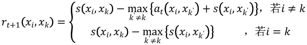
And if t is the matrix updating frequency, the updating iteration method of the attraction degree matrix R is as follows:
rt+1(xi,xk)=(1-λ)·rt+1(xi,xk)+λ·rt(xi,xk)
wherein the content of the first and second substances,

where t is the number of updates of the matrix R, xk′As a competition point, candidate point xkFitting as data points xiThe degree of cluster center of (2) is expressed as an attraction degree r (x)i,xk) Data point xiSelecting candidate points xkThe suitability of the cluster center is denoted as the degree of attribution a (x)i,xk) Data point xiAnd candidate point xkIs recorded as s (x)i,xk)。
The updating iteration method of the attribution degree matrix A is as follows:
at+1(xi,xk)=(1-λ)·at+1(xi,xk)+λ·at(xi,xk)
wherein the content of the first and second substances,

where t is the number of updates of matrix A, xk′As a competition point, data point xiSelecting candidate points xkThe suitability as the clustering center is described as the degree of attribution a (x)i,xk) Candidate point xkFitting as data points xiThe degree of the cluster center of (2) is expressed as an attraction degree r (x)i,xk)。
And S3, carrying out data reconstruction on the clustering result obtained in the step S2 to obtain a final point annotation target result.
Referring to fig. 7, the step S3 is as follows:
s31, setting the point group subclass currently needing to be reconstructed as Y ═ Y1,y2,…,ykThe semantic importance is Q ═ Q respectively1,q2,…,qkAcquiring all the objects in the subclass Y, including fonts, sizes, positions, the number of subclasses and semantic importance information;
s32, setting a clustering center point ycOf semantic importance qc,c≤k,0≤qcLess than or equal to 1 when Then, calculating to obtain a clustering center point y according to the comprehensive attributes of all targets of the current subclass, including fonts, sizes, positions and numberscThe multiple attributes of (2) include font, size, position and number of subclasses;
and S33, fusing the reconstructed cluster center point marks in each partition to obtain a final global cluster result.
The previous description of the disclosed embodiments is provided to enable any person skilled in the art to make or use the present invention. Various modifications to these embodiments will be readily apparent to those skilled in the art, and the generic principles defined herein may be applied to other embodiments without departing from the spirit or scope of the invention. Thus, the present invention is not intended to be limited to the embodiments shown herein but is to be accorded the widest scope consistent with the principles and novel features disclosed herein.
Claims (4)
1. An aviation geophysical mapping data space point aggregation method is characterized by comprising the following steps:
s1, dividing the data of the extracted target point group to construct a similarity matrix;
the constructed similarity matrix is specifically as follows:
assume that the set of data points is X ═ X1,x2,…,xnAnd then its similarity matrix S is as follows:

data point xiAnd xjThe similarity between them is defined as sijRepresents a point xjAs a point xiUsing the negative euclidean distance as the similarity between two points, as shown in the following equation:

in the above formula, d represents the number of descriptive features of each data point, xikAnd xjkRespectively represent xiAnd xjK is not less than 1 and not more than d, and sijThe larger the distance between the two data points is, the higher the similarity is;
reference degree siiIs defined as follows:
sii=(1-q)×p
where p is a set reference value and q represents a target xiQ is more than or equal to 0 and less than or equal to 1, and the larger the value of q is, the target x is representediThe higher the semantic importance of, p<0, the closer the value of q is to 1, the reference siiThe closer to 0, xiThe higher the probability of being selected as a cluster center;
s2, clustering the similarity matrix constructed in the step S1 by using a clustering algorithm to obtain a clustering result;
s3, carrying out data reconstruction on the clustering result obtained in the step S2 to obtain a final point annotation target result;
step S3 is specifically implemented as follows:
s31, setting the point group subclass currently needing to be reconstructed as Y ═ Y1,y2,…,ykWith semantic importance Q ═ Q, respectively1,q2,…,qkAcquiring all the objects in the subclass Y, including fonts, sizes, positions, the number of subclasses and semantic importance information;
s32, setting a clustering center point ycWith semantic importance of qc,c≤k,0≤qcLess than or equal to 1, when Then, calculating to obtain a clustering center point y according to the comprehensive attributes of all targets of the current subclass, including fonts, sizes, positions and numberscThe multiple attributes comprise font, size, position and subclass number;
and S33, fusing the reconstructed cluster central point marks in each partition to obtain a final global clustering result.
2. The method for aggregating the spatial points of the aviation geophysical mapping data according to claim 1, wherein the clustering operation in step S2 is specifically as follows:
s21, constructing a k-adjacent graph, calculating a similarity matrix S, and setting point annotation target semantic importance Q ═ Q1,q2… }, reference value p, damping coefficient lambda, maximum number of iterations t of the attraction matrix and the attribution matrixmaxThe clustering result stabilization times e, the reference degree adjustment step length mu and k being 1;
s22, executing the K round of AP clustering;
s221, setting the attraction degree matrix R ═ Rik]=[0]And the attribution matrix A ═ aik]=[0]Updating iteration number t equal to 0 and clustering stable number ek=0;
S222, updating R and a, t ═ t + 1;
s223, if the current clustering result is judged to be consistent with the t-1 clustering result, ek=ek+1, otherwise ek=0;
S224, if t reaches the maximum iteration time tmaxOr the stable times of the clustering result reach e, terminating the clustering process, recording the clustering result and counting the number a of subclasseskStep S23 is executed; otherwise, go to step S222;
s23, judging whether a is satisfiedk-1≤n≤akOr ak≤n≤ak-1If yes, outputting a final clustering result according to the step S231; otherwise, go to step S232;
s231, if | ak-1-n|<|akOutputting a k-1 round clustering result; otherwise, outputting the k-th clustering result;
s232, if ak>n, the adjustment parameter p is (1+ μ) × p; otherwise, adjust p ═ p (1- μ) × p; each target reference degree is recalculated and the similarity matrix S, k — k +1 is updated, and step S22 is performed.
3. The method for aggregating spatial points of airborne geophysical mapping data as claimed in claim 2, wherein if t is the number of matrix updates, the iterative method for updating the attraction matrix R is as follows:
rt+1(xi,xk)=(1-λ)·rt+1(xi,xk)+λ·rt(xi,xk)
wherein, the first and the second end of the pipe are connected with each other,
wherein, λ is damping coefficient, λ belongs to [0, 1]]T is the number of updates of the matrix R, xk'As a competition point, candidate point xkFitting as data points xiThe degree of cluster center of (2) is expressed as an attraction degree r (x)i,xk) Data point xiSelecting candidate points xkAs the appropriateness of the clustering center, it is recorded as a degree of attribution a (x)i,xk) Data point xiAnd candidate point xkIs recorded as s (x)i,xk)。
4. The method for aggregating spatial points of aviation geophysical cartographic data according to claim 2, wherein the iterative method for updating the attribution degree matrix A is as follows:
at+1(xi,xk)=(1-λ)·at+1(xi,xk)+λ·at(xi,xk)
wherein the content of the first and second substances,

wherein, λ is damping coefficient, λ belongs to [0, 1]]T is the number of updates of the matrix A, xk'As a competition point, data point xiSelecting candidate points xkThe suitability of the cluster center is denoted as the degree of attribution a (x)i,xk) Candidate point xkFitting as data points xiThe degree of cluster center of (2) is expressed as an attraction degree r (x)i,xk)。
Priority Applications (1)
| Application Number | Priority Date | Filing Date | Title |
|---|---|---|---|
| CN202011375697.2A CN112417078B (en) | 2020-11-30 | 2020-11-30 | Space point aggregation method for aviation geophysical mapping data |
Applications Claiming Priority (1)
| Application Number | Priority Date | Filing Date | Title |
|---|---|---|---|
| CN202011375697.2A CN112417078B (en) | 2020-11-30 | 2020-11-30 | Space point aggregation method for aviation geophysical mapping data |
Publications (2)
| Publication Number | Publication Date |
|---|---|
| CN112417078A CN112417078A (en) | 2021-02-26 |
| CN112417078B true CN112417078B (en) | 2022-06-24 |
Family
ID=74829023
Family Applications (1)
| Application Number | Title | Priority Date | Filing Date |
|---|---|---|---|
| CN202011375697.2A Active CN112417078B (en) | 2020-11-30 | 2020-11-30 | Space point aggregation method for aviation geophysical mapping data |
Country Status (1)
| Country | Link |
|---|---|
| CN (1) | CN112417078B (en) |
Citations (5)
| Publication number | Priority date | Publication date | Assignee | Title |
|---|---|---|---|---|
| CN102136218A (en) * | 2011-03-17 | 2011-07-27 | 武汉大学 | Automatic collocation method for map lettering during map making through computer |
| CN103489363A (en) * | 2012-06-08 | 2014-01-01 | 北京华胜天成科技股份有限公司 | Method and system for processing linear feature labeling data in electronic mapping system |
| CN104537254A (en) * | 2015-01-07 | 2015-04-22 | 中国科学院地理科学与资源研究所 | Fine drawing method based on social statistical data |
| CN109242759A (en) * | 2018-07-16 | 2019-01-18 | 杭州电子科技大学 | Figure based on Density Clustering shrinks grouping method for registering |
| CN109542990A (en) * | 2018-10-25 | 2019-03-29 | 中国地质大学(武汉) | Airborne geophysics cartographic data point element automates map name placement method |
-
2020
- 2020-11-30 CN CN202011375697.2A patent/CN112417078B/en active Active
Patent Citations (5)
| Publication number | Priority date | Publication date | Assignee | Title |
|---|---|---|---|---|
| CN102136218A (en) * | 2011-03-17 | 2011-07-27 | 武汉大学 | Automatic collocation method for map lettering during map making through computer |
| CN103489363A (en) * | 2012-06-08 | 2014-01-01 | 北京华胜天成科技股份有限公司 | Method and system for processing linear feature labeling data in electronic mapping system |
| CN104537254A (en) * | 2015-01-07 | 2015-04-22 | 中国科学院地理科学与资源研究所 | Fine drawing method based on social statistical data |
| CN109242759A (en) * | 2018-07-16 | 2019-01-18 | 杭州电子科技大学 | Figure based on Density Clustering shrinks grouping method for registering |
| CN109542990A (en) * | 2018-10-25 | 2019-03-29 | 中国地质大学(武汉) | Airborne geophysics cartographic data point element automates map name placement method |
Non-Patent Citations (1)
| Title |
|---|
| 基于近邻传播算法的航迹聚类分析;张榆薪等;《软件导刊》;20180415(第04期);第90,100页 * |
Also Published As
| Publication number | Publication date |
|---|---|
| CN112417078A (en) | 2021-02-26 |
Similar Documents
| Publication | Publication Date | Title |
|---|---|---|
| CN107808518B (en) | Traffic cell classification method based on multi-path spectral clustering theory | |
| CN109948066B (en) | Interest point recommendation method based on heterogeneous information network | |
| CN110188228A (en) | Cross-module state search method based on Sketch Searching threedimensional model | |
| CN102571431B (en) | Group concept-based improved Fast-Newman clustering method applied to complex network | |
| KR102473155B1 (en) | Method for providing interactive information service and apparatus therefor | |
| CN106845536A (en) | A kind of parallel clustering method based on image scaling | |
| CN110580252B (en) | Space object indexing and query method under multi-objective optimization | |
| CN110909172A (en) | Knowledge representation learning method based on entity distance | |
| CN107832583B (en) | Cross-species biological pathway discovery method based on graph matching | |
| CN115293919A (en) | Graph neural network prediction method and system oriented to social network distribution generalization | |
| CN115481682A (en) | Graph classification training method based on supervised contrast learning and structure inference | |
| CN103164487B (en) | A kind of data clustering method based on density and geological information | |
| CN108614932B (en) | Edge graph-based linear flow overlapping community discovery method, system and storage medium | |
| CN112417078B (en) | Space point aggregation method for aviation geophysical mapping data | |
| CN105138607B (en) | A kind of KNN querying methods based on combination grain distributed memory grid index | |
| CN109472712A (en) | A kind of efficient Markov random field Combo discovering method strengthened based on structure feature | |
| CN116932923A (en) | Project recommendation method combining behavior characteristics and triangular collaboration metrics | |
| CN108897820B (en) | Parallelization method of DENCLUE algorithm | |
| CN111738514A (en) | Social network community discovery method using local distance and node rank optimization function | |
| CN114662012A (en) | Community query analysis method oriented to gene regulation network | |
| CN109033746A (en) | A kind of protein complex recognizing method based on knot vector | |
| CN111782969B (en) | Social network maximum influence node selection method based on geographic area | |
| Obaid et al. | Hybrid variable-length spider monkey optimization with good-point set initialization for data clustering | |
| CN114817653A (en) | Unsupervised community discovery method based on central node graph convolutional network | |
| Aparco-Cardenas et al. | Object delineation by iterative dynamic trees |
Legal Events
| Date | Code | Title | Description |
|---|---|---|---|
| PB01 | Publication | ||
| PB01 | Publication | ||
| SE01 | Entry into force of request for substantive examination | ||
| SE01 | Entry into force of request for substantive examination | ||
| GR01 | Patent grant | ||
| GR01 | Patent grant |