CN111095314A - Yield estimation for crop plant planting - Google Patents
Yield estimation for crop plant planting Download PDFInfo
- Publication number
- CN111095314A CN111095314A CN201880054195.4A CN201880054195A CN111095314A CN 111095314 A CN111095314 A CN 111095314A CN 201880054195 A CN201880054195 A CN 201880054195A CN 111095314 A CN111095314 A CN 111095314A
- Authority
- CN
- China
- Prior art keywords
- weather
- crop
- growth
- measures
- yield
- Prior art date
- Legal status (The legal status is an assumption and is not a legal conclusion. Google has not performed a legal analysis and makes no representation as to the accuracy of the status listed.)
- Pending
Links
- 244000038559 crop plants Species 0.000 title claims abstract description 108
- 230000012010 growth Effects 0.000 claims description 199
- 238000000034 method Methods 0.000 claims description 68
- 238000003306 harvesting Methods 0.000 claims description 46
- 238000004590 computer program Methods 0.000 claims description 33
- 206010061217 Infestation Diseases 0.000 claims description 23
- 230000007704 transition Effects 0.000 claims description 16
- 230000008569 process Effects 0.000 claims description 15
- 238000004364 calculation method Methods 0.000 claims description 11
- 238000013500 data storage Methods 0.000 claims description 6
- 238000012545 processing Methods 0.000 claims description 4
- 238000001228 spectrum Methods 0.000 claims description 4
- 241000196324 Embryophyta Species 0.000 description 33
- 238000004519 manufacturing process Methods 0.000 description 27
- 230000008635 plant growth Effects 0.000 description 25
- 239000002689 soil Substances 0.000 description 24
- 238000009331 sowing Methods 0.000 description 20
- 241000607479 Yersinia pestis Species 0.000 description 17
- 230000009471 action Effects 0.000 description 17
- 230000007774 longterm Effects 0.000 description 11
- 230000001932 seasonal effect Effects 0.000 description 10
- 238000001556 precipitation Methods 0.000 description 9
- 235000015097 nutrients Nutrition 0.000 description 7
- IJGRMHOSHXDMSA-UHFFFAOYSA-N Atomic nitrogen Chemical compound N#N IJGRMHOSHXDMSA-UHFFFAOYSA-N 0.000 description 6
- 238000009826 distribution Methods 0.000 description 6
- 238000003973 irrigation Methods 0.000 description 6
- 230000002262 irrigation Effects 0.000 description 6
- 238000004088 simulation Methods 0.000 description 6
- 201000010099 disease Diseases 0.000 description 5
- 208000037265 diseases, disorders, signs and symptoms Diseases 0.000 description 5
- 230000000694 effects Effects 0.000 description 5
- 230000009545 invasion Effects 0.000 description 5
- 241000209504 Poaceae Species 0.000 description 4
- 238000005259 measurement Methods 0.000 description 4
- OKTJSMMVPCPJKN-UHFFFAOYSA-N Carbon Chemical compound [C] OKTJSMMVPCPJKN-UHFFFAOYSA-N 0.000 description 3
- 230000002411 adverse Effects 0.000 description 3
- 229910052799 carbon Inorganic materials 0.000 description 3
- 238000004891 communication Methods 0.000 description 3
- 238000003967 crop rotation Methods 0.000 description 3
- 230000007613 environmental effect Effects 0.000 description 3
- 230000002349 favourable effect Effects 0.000 description 3
- 239000003337 fertilizer Substances 0.000 description 3
- 230000002068 genetic effect Effects 0.000 description 3
- 229910052500 inorganic mineral Inorganic materials 0.000 description 3
- 239000011707 mineral Substances 0.000 description 3
- 229910052757 nitrogen Inorganic materials 0.000 description 3
- 230000005855 radiation Effects 0.000 description 3
- XLYOFNOQVPJJNP-UHFFFAOYSA-N water Substances O XLYOFNOQVPJJNP-UHFFFAOYSA-N 0.000 description 3
- 241000700605 Viruses Species 0.000 description 2
- 230000008901 benefit Effects 0.000 description 2
- 238000011156 evaluation Methods 0.000 description 2
- 230000004720 fertilization Effects 0.000 description 2
- 230000002538 fungal effect Effects 0.000 description 2
- 239000003630 growth substance Substances 0.000 description 2
- 230000003993 interaction Effects 0.000 description 2
- 230000001788 irregular Effects 0.000 description 2
- 239000000463 material Substances 0.000 description 2
- 210000000056 organ Anatomy 0.000 description 2
- 244000052769 pathogen Species 0.000 description 2
- 230000003595 spectral effect Effects 0.000 description 2
- 230000003442 weekly effect Effects 0.000 description 2
- UHPMCKVQTMMPCG-UHFFFAOYSA-N 5,8-dihydroxy-2-methoxy-6-methyl-7-(2-oxopropyl)naphthalene-1,4-dione Chemical compound CC1=C(CC(C)=O)C(O)=C2C(=O)C(OC)=CC(=O)C2=C1O UHPMCKVQTMMPCG-UHFFFAOYSA-N 0.000 description 1
- 241000894006 Bacteria Species 0.000 description 1
- 239000002028 Biomass Substances 0.000 description 1
- 241001480061 Blumeria graminis Species 0.000 description 1
- 241000195940 Bryophyta Species 0.000 description 1
- 244000025254 Cannabis sativa Species 0.000 description 1
- 241000254173 Coleoptera Species 0.000 description 1
- 241000209020 Cornus Species 0.000 description 1
- 101100326341 Drosophila melanogaster brun gene Proteins 0.000 description 1
- 241000221785 Erysiphales Species 0.000 description 1
- 241000233866 Fungi Species 0.000 description 1
- 241000223218 Fusarium Species 0.000 description 1
- 241001149959 Fusarium sp. Species 0.000 description 1
- 240000003183 Manihot esculenta Species 0.000 description 1
- 241001465754 Metazoa Species 0.000 description 1
- 241000985694 Polypodiopsida Species 0.000 description 1
- 241000221300 Puccinia Species 0.000 description 1
- 241000228453 Pyrenophora Species 0.000 description 1
- PPCUPSGMDOTIMV-UHFFFAOYSA-N Sachalin Natural products CC1=C/C2OC(=O)C(=C)C2C(O)CC(=C)C(O)CC1 PPCUPSGMDOTIMV-UHFFFAOYSA-N 0.000 description 1
- 241001533598 Septoria Species 0.000 description 1
- 230000002776 aggregation Effects 0.000 description 1
- 238000004220 aggregation Methods 0.000 description 1
- 230000003698 anagen phase Effects 0.000 description 1
- 238000004458 analytical method Methods 0.000 description 1
- 230000005540 biological transmission Effects 0.000 description 1
- 230000008859 change Effects 0.000 description 1
- 238000009313 farming Methods 0.000 description 1
- 230000006870 function Effects 0.000 description 1
- 239000000417 fungicide Substances 0.000 description 1
- 239000003673 groundwater Substances 0.000 description 1
- 239000004009 herbicide Substances 0.000 description 1
- 238000003898 horticulture Methods 0.000 description 1
- 238000010191 image analysis Methods 0.000 description 1
- 239000002917 insecticide Substances 0.000 description 1
- 238000012804 iterative process Methods 0.000 description 1
- 230000004807 localization Effects 0.000 description 1
- 238000013178 mathematical model Methods 0.000 description 1
- 238000000691 measurement method Methods 0.000 description 1
- 239000000203 mixture Substances 0.000 description 1
- 238000012544 monitoring process Methods 0.000 description 1
- 238000010899 nucleation Methods 0.000 description 1
- 239000000575 pesticide Substances 0.000 description 1
- 238000011160 research Methods 0.000 description 1
- 241000894007 species Species 0.000 description 1
- 238000004611 spectroscopical analysis Methods 0.000 description 1
- 239000007921 spray Substances 0.000 description 1
- 238000005507 spraying Methods 0.000 description 1
- 238000003860 storage Methods 0.000 description 1
- 239000000126 substance Substances 0.000 description 1
- 230000002123 temporal effect Effects 0.000 description 1
- 230000001960 triggered effect Effects 0.000 description 1
- 230000035899 viability Effects 0.000 description 1
- 230000003936 working memory Effects 0.000 description 1
Images


Classifications
-
- A—HUMAN NECESSITIES
- A01—AGRICULTURE; FORESTRY; ANIMAL HUSBANDRY; HUNTING; TRAPPING; FISHING
- A01B—SOIL WORKING IN AGRICULTURE OR FORESTRY; PARTS, DETAILS, OR ACCESSORIES OF AGRICULTURAL MACHINES OR IMPLEMENTS, IN GENERAL
- A01B79/00—Methods for working soil
- A01B79/005—Precision agriculture
-
- G—PHYSICS
- G06—COMPUTING; CALCULATING OR COUNTING
- G06Q—INFORMATION AND COMMUNICATION TECHNOLOGY [ICT] SPECIALLY ADAPTED FOR ADMINISTRATIVE, COMMERCIAL, FINANCIAL, MANAGERIAL OR SUPERVISORY PURPOSES; SYSTEMS OR METHODS SPECIALLY ADAPTED FOR ADMINISTRATIVE, COMMERCIAL, FINANCIAL, MANAGERIAL OR SUPERVISORY PURPOSES, NOT OTHERWISE PROVIDED FOR
- G06Q10/00—Administration; Management
- G06Q10/06—Resources, workflows, human or project management; Enterprise or organisation planning; Enterprise or organisation modelling
- G06Q10/063—Operations research, analysis or management
- G06Q10/0631—Resource planning, allocation, distributing or scheduling for enterprises or organisations
-
- G—PHYSICS
- G01—MEASURING; TESTING
- G01W—METEOROLOGY
- G01W1/00—Meteorology
- G01W1/10—Devices for predicting weather conditions
-
- G—PHYSICS
- G06—COMPUTING; CALCULATING OR COUNTING
- G06Q—INFORMATION AND COMMUNICATION TECHNOLOGY [ICT] SPECIALLY ADAPTED FOR ADMINISTRATIVE, COMMERCIAL, FINANCIAL, MANAGERIAL OR SUPERVISORY PURPOSES; SYSTEMS OR METHODS SPECIALLY ADAPTED FOR ADMINISTRATIVE, COMMERCIAL, FINANCIAL, MANAGERIAL OR SUPERVISORY PURPOSES, NOT OTHERWISE PROVIDED FOR
- G06Q10/00—Administration; Management
- G06Q10/04—Forecasting or optimisation specially adapted for administrative or management purposes, e.g. linear programming or "cutting stock problem"
-
- G—PHYSICS
- G06—COMPUTING; CALCULATING OR COUNTING
- G06Q—INFORMATION AND COMMUNICATION TECHNOLOGY [ICT] SPECIALLY ADAPTED FOR ADMINISTRATIVE, COMMERCIAL, FINANCIAL, MANAGERIAL OR SUPERVISORY PURPOSES; SYSTEMS OR METHODS SPECIALLY ADAPTED FOR ADMINISTRATIVE, COMMERCIAL, FINANCIAL, MANAGERIAL OR SUPERVISORY PURPOSES, NOT OTHERWISE PROVIDED FOR
- G06Q10/00—Administration; Management
- G06Q10/06—Resources, workflows, human or project management; Enterprise or organisation planning; Enterprise or organisation modelling
- G06Q10/063—Operations research, analysis or management
- G06Q10/0631—Resource planning, allocation, distributing or scheduling for enterprises or organisations
- G06Q10/06313—Resource planning in a project environment
-
- G—PHYSICS
- G06—COMPUTING; CALCULATING OR COUNTING
- G06Q—INFORMATION AND COMMUNICATION TECHNOLOGY [ICT] SPECIALLY ADAPTED FOR ADMINISTRATIVE, COMMERCIAL, FINANCIAL, MANAGERIAL OR SUPERVISORY PURPOSES; SYSTEMS OR METHODS SPECIALLY ADAPTED FOR ADMINISTRATIVE, COMMERCIAL, FINANCIAL, MANAGERIAL OR SUPERVISORY PURPOSES, NOT OTHERWISE PROVIDED FOR
- G06Q50/00—Systems or methods specially adapted for specific business sectors, e.g. utilities or tourism
- G06Q50/02—Agriculture; Fishing; Mining
Abstract
The present invention relates to the field of growing crop plants, and in particular to the creation of forecasts of expected yield.
Description
Technical Field
The present invention relates to the field of crop plant growth, and in particular to creating forecasts of expected yield.
Background
The yield of growing crop plants is determined by a variety of parameters. Some of which may be affected by the farmer, such as soil cultivation, type, date and density of sowing, implementation of measures to control harmful organisms, deployment of nutrients, irrigation and harvest date. Other parameters, such as weather, are hardly affected.
It would be advantageous for the farmer to know what yield he can expect at the end of the growth period. It would also be advantageous to know how agricultural measures would affect yield.
The invention provides farmers with such information.
Disclosure of Invention
The invention firstly provides a method for determining the yield expected in the growth of crop plants, preferably by means of a computer system, such as a server, in particular a server, and a local or mobile computer system, comprising the steps of:
(A) preferably, in case position data, in particular geographical coordinates, are provided, a field in which the crop plants are growing or are to be grown is identified,
(B) considering the weather progression so far, it is preferable to predict the weather progression of the field during the upcoming or ongoing growth of the crop up to the planned harvest, with a seamless transition of the weather progression so far and the predicted weather progression, the forecast
(C) Forecasting the occurrence of one or more harmful organisms in the field within the forecasted weather schedule,
(D) preferably by providing action data that at least partially determines an upcoming or ongoing growth period of agricultural action, determining an upcoming or ongoing growth period of crop plants until the planned harvest of agricultural action,
(E) calculating the yield expected in the growth of the crop plants, provided that the forecast of steps (B) and (C) is correct and that the measures determined in step (D) have been implemented,
(F) to provide or display the desired yield of the product,
(G) preferably, weather data relating to the actual course of the weather are provided for step (B), and recorded field-specific data, in particular harmful-organism data relating to harmful organisms that have actually occurred and measure data relating to measures that have actually been carried out, are provided for steps (C), (D), (E),
preferably forecasting at least two different weather courses in step (B) and performing steps (C), (D), (E) for each of the at least two different weather courses,
the steps (B), (C), (D), (E) and (F) are repeatedly performed in consideration of the actual course of the weather, harmful organisms that have actually occurred and measures that have actually been implemented up to the respective moments of performing the steps.
The present invention further provides a computer system, preferably for determining the yield expected in the growth of a crop plant, comprising:
(A) preferably by providing location data, in particular geographical coordinates, identifying a component of the field in which crop plants are growing or are to be grown, or a logging module configured to provide location data, in particular geographical coordinates,
(B) means for providing a forecast of the weather progression of the field during upcoming or ongoing growth of the crop plants up to the planned harvest taking into account the weather progression so far, preferably with the weather progression so far and with a seamless transition of the forecasted weather progression, the forecast or a weather module configured for providing a forecast of the weather progression of the field during upcoming or ongoing growth of the crop plants up to the planned harvest taking into account the weather progression so far, preferably with the weather progression so far and with a seamless transition of the forecasted weather progression, the forecast or a weather progression
(C) Means for providing a forecast of the occurrence of one or more harmful organisms in the field within a forecast weather course, or a harmful organisms module configured to provide a forecast of the occurrence of one or more harmful organisms in the field within a forecast weather course,
(D) means for identifying upcoming or ongoing periods of growth of the crop plants up to the planned harvest of agricultural measures, preferably by providing measure data that at least partially determines upcoming or ongoing periods of growth of agricultural measures, or a measure module configured for identifying upcoming or ongoing periods of growth of the crop plants up to the planned harvest of agricultural measures, preferably by providing measure data that partially determines upcoming or ongoing periods of growth of agricultural measures,
(E) means for calculating the yield expected in the growth of the crop plant, assuming that the forecast of steps (B) and (C) is correct and the measure determined in step (D) has been implemented, or a yield module configured for calculating the yield expected in the growth of the crop plant, assuming that the forecast of steps (B) and (C) is correct and the measure determined in step (D) has been implemented
(F) A component that displays or provides a desired production, or an interface configured to display or provide a desired production,
wherein the computer system is configured such that, preferably by providing weather data relating to the actual course of the weather for step (B) and providing recorded field-specific data for steps (C), (D), (E), in particular harmful organism data relating to harmful organisms that have actually occurred and measure data relating to measures that have actually been carried out,
preferably, the steps (B), (C), (D), (E) and (F) are repeatedly performed by forecasting at least two different weather courses in step (B) and performing steps (C), (D), (E) for each of the at least two different weather courses, taking into account the actual course of the weather, the harmful organisms that have actually occurred and the measures that have actually been implemented up to the respective moment of performing the steps.
The present invention further provides a computer program product, preferably for determining the yield expected in the growth of a crop plant, comprising a computer readable data storage means and program code stored on the data storage means and which, when executed on a computer system, causes the computer system to perform the steps of:
(A) the field in which the crop plants are growing or are to be grown is preferably determined by providing position data, in particular geographical coordinates,
(B) considering the weather schedule so far, it is preferable to employ the weather schedule so far and the seamless transition of the forecasted weather schedule to determine the weather schedule of the field during the upcoming or ongoing growth of the crop plants until the planned harvest, the forecasted weather schedule
(C) Determining a forecast of the occurrence of one or more harmful organisms in the field within a forecast weather course,
(D) preferably by providing action data that at least partially determines an upcoming or ongoing growth period of agricultural action, determining an upcoming or ongoing growth period of crop plants until the planned harvest of agricultural action,
(E) calculating the yield expected in the growth of the crop plants, provided that the forecast of steps (B) and (C) is correct and that the measures determined in step (D) have been implemented,
(F) to provide or display the desired yield of the product,
(G) preferably, by providing weather data relating to the actual course of the weather for step (B) and providing recorded field-specific data for steps (C), (D), (E), in particular harmful-organism data relating to harmful organisms that have actually occurred and measure data relating to measures that have actually been carried out,
preferably, the steps (B), (C), (D), (E) and (F) are repeatedly performed by forecasting at least two different weather courses in step (B) and performing steps (C), (D), (E) for each of the at least two different weather courses, taking into account the actual course of the weather, the harmful organisms that have actually occurred and the measures that have actually been implemented up to the respective moment of performing the steps.
The present invention is described in detail below without distinguishing between the subject matter of the present invention (method, computer system, computer program product). Rather, the following description is intended to apply analogously to all subject matter of the present invention, regardless of their context (method, computer system, computer program product).
The method of the present invention is used to assist farmers in the growth of crop plants in the field.
The term "field" is understood to mean a spatially definable area of the earth's surface which is intended for agricultural use by planting crop plants in such a field, providing them with nutrients and harvesting them.
The term "crop plant" is understood to mean a plant which is intentionally grown as a useful or ornamental plant by human intervention.
(A) Identifying fields in which crop plants are growing or are to be grown
In a first step, fields that are growing or are about to grow crop plants are identified and considered in detail during the process of the present invention.
Typically, the identification is made using geographic coordinates that unambiguously determine the location of the field. The method of the present invention is typically performed by means of a computer program installed on a computer system. Therefore, the geographical coordinates of the field are typically transmitted into a computer program. For example, a user of the computer program may enter the geographical coordinates via a keyboard. It is also conceivable that a user of the computer program views a geographical map on a computer screen and marks the border of the field under consideration on such a map, for example with a computer mouse.
The identification of the field thus fixes the region of the earth's surface that is considered in the further course of the method of the invention.
(B) Forecasting weather progress
In a further step, the weather progression forecast during the upcoming or ongoing growth period of the crop plant up to the planned harvest is forecast, preferably with the weather progression so far taken into account and a seamless transition of the forecasted weather progression.
The purpose of weather forecasting is to forecast the distribution and corresponding probability of an upcoming or ongoing growing weather event with maximum accuracy.
It is well known that weather forecasts on days in the future (e.g., up to nine days) can be relatively accurate, while weather forecasts on days in weeks or months in the future (e.g., greater than nine days) are relatively inaccurate. Thus, for periods of weather that can only be forecast inaccurately, historical weather data is well suited to use trends that have been frequently observed over the past few years as the basis for future weather forecasts.
Weather forecasts for the near future (e.g., up to about one week or up to about 9 days a day) may be obtained, for example, from a number of commercial suppliers.
Seasonal weather forecasts are preferentially used for the further future within the growing period (e.g. more than a week or more than nine days). These forecasts can be based here on, for example, global, regional and global area coupled dynamic circulation models and/or long-term statistics of historical weather data and/or dynamic predictions of individual climate variables (circulation models) in combination with random weather simulations and/or purely random weather simulations of other variables.
In particular, the seasonal forecast may be provided by a commercial supplier and/or a research institution.
The decision as to which seasonal forecast to employ depends on the forecast quality of the model. To this end, an index, such as a Brier score (Brier score), may be used. Below a certain limit below which the increase in the modeled weather forecast is insignificant with respect to the long-term climate statistics, seasonal weather forecasts based on the long-term climate statistics are preferentially used.
It is conceivable to create a number of forecasts, called forecasts. It is contemplated that using historical weather data, a typical (e.g., most likely) or average weather course (average weather course over a defined time period, such as the last three, four, five, six, seven, eight, nine, ten years) may be determined. It is conceivable to determine a weather forecast for a particular season that seems to be more likely than others based on the recent past.
It is contemplated that historical weather data may additionally be used to forecast a relatively favorable weather course from an agricultural perspective and/or a relatively unfavorable weather course.
In a preferred embodiment, a plurality of weather forecasts is created, preferably covering the spectrum of weather processes occurring over the last years. In a preferred embodiment, the probability of occurrence of each weather course is also determined and reported so that the weather courses can be compared to each other.
Different weather processes (history, recent forecast, seasonal forecast, forecast) are combined in a seamless time series ("seamless prediction").
(C) Forecasting of occurrence of one or more harmful organisms
For each forecasted weather schedule, in a further step of the method of the invention, the occurrence of one or more harmful organisms is forecasted.
Preferably, the forecasting determines the risk of infestation by one or more harmful organisms.
"harmful organisms" are understood to mean organisms which can occur in the growth of crop plants and which can damage the crop plants, adversely affect the harvesting of the crop plants or compete with the crop plants for natural resources. Examples of such harmful organisms are weed plants, grasses, animal pests (e.g. beetles, caterpillars and worms), fungi and pathogens (e.g. bacteria and viruses). Even if the virus is not included in the organism from a biological point of view, the term "harmful organism" should be used herein to cover them.
Specific examples of harmful organisms include: three seasons of sachalin (Septoria Tritilii) (https:// gd. eppo. int/taxon/SEPTTR), Grignard (Erysiphe graminis) (https:// gd. eppo. int/taxon/ERYSGR), powdery mildew (Puccinia recondite) (https:// gd. eppo. int/taxon/PUCCH), Pipellus trilobata (Pyrophora tricuspid-reptitis) or Deerhella trilobata (Drechslera tricuspid-reptitis) (https:// gd. eppo. int/taxon/PYRNTR) and Fusarium sp (Fusarium sp.) (https:// gpo. int/taxon/SP).
The term "weed plants" (multiplicity: weed plants) is understood to mean plants of the crop plant, of the vegetation (cornus) which accompany spontaneously in the lawn or garden and which are not intended to be planted here, but develop from potential seeds in the soil or by aerial propagation. The term is not limited to weeds in a practical sense but also includes grasses, ferns, mosses or woody plants.
In the field of crop plant protection, the term "grasses" (multiplicity: grasses) is also frequently used in order to illustrate the boundary with herbaceous plants. Herein, the term "weeds" is used as a covering term intended to include the term "grassy weeds".
For predicting the occurrence of one or more harmful organisms, for example, predictive models described in the prior art may be used. The commercially available decision support System "expert" for prediction uses data relating to The crop plants being grown or about to be grown (developmental stage, growth conditions, crop protection measures), data relating to weather conditions (temperature, sunshine time, wind speed, precipitation), and data relating to known harmful organisms/diseases (limits of economic viability, pressure of seedlings/diseases), and calculates The risk of attack based on these data (Newe M., Meier H., John A., Volk T. plant ex. com-an online monitoring System on crop protection informals, Rape, posts and super. EPPO Bulletin 2003, 33, 443-, (2010) ed. Ingrid H.Williams.Tartu 51014, Estania.ISBN 978-90-481-; www.proPlantexpert.com).
Past actual attacks can also be taken into account in order to predict harmful organisms.
Preferably, the risk of infestation is determined for those harmful organisms that have occurred in the field in question and/or in the adjacent fields in the past.
The risk of an attack is preferably determined in a region-specific manner. It is conceivable, for example, that some part-areas of the field are particularly frequently and/or particularly significantly affected by harmful organisms due to their position and/or that attack by harmful organisms often originates from one or more defined part-areas.
In a preferred embodiment, for forecasting the weather progression, a digital map of one or more fields is generated, in which the risk of attack by one or more harmful organisms is plotted in a region-specific manner. For example, it is conceivable to generate a series of digital maps for defined harmful organisms, for example one map per month in a year, and to indicate, by means of a colour coding on the map, how high the risk of attack is for the part of the area with the harmful organisms in the month in question and with the forecasted weather progression. For example, the color "red" may mean greater than 90% of the risk of attack, and the color "green" may mean less than 10% of the risk of attack. Different shades of yellow and orange may be used in the range between 10% and 90%. Other/further modes of representation are conceivable.
In a preferred embodiment, the determined risk of an attack as to whether the damage threshold is exceeded is evaluated.
"damage threshold" is a term from agriculture, forestry and horticulture. It indicates the density of infestation by pathogens or diseases or weed infestation from which control is economically unfeasible. When this value is reached, the additional economic expenditure by control is greater than the harvesting failure which is at risk. If the infestation or weed pressure exceeds this value, the cost of control is at least offset by the expected additional yield.
The damage threshold may vary greatly depending on the nature of the harmful organism or disease. In the case of harmful organisms or diseases which can only be controlled with high expenditure and adverse concomitant effects on further production, the damage threshold can be high. However, if even a small scale attack could be a source of spread threatening damage to the entire production, the damage threshold could be very low.
There are many examples in the prior art relating to determining damage thresholds (see, for example, Claus M. Brodersen: information in Schadschwellenmodelen [ information in damage threshold model ], report by GIL [ German society of agricultural computer sciences, forestry and food sciences ], Vol 7, pages 26 to 36, http:// www.gil-net. de/Publikationen/7-26. pdf).
(D) Determining agricultural measures
In a further step, agricultural measures are determined for the period of upcoming or ongoing crop plant growth until planned harvest.
The term "agricultural measures" is understood to mean any measures in a field of crop plants which are necessary or economically feasible and/or environmentally desirable for obtaining plant products. Examples of agricultural measures are: soil cultivation (e.g., farming), seed deployment (sowing), irrigation, application of growth regulators, weed/grass control, nutrient deployment (e.g., by fertilization), pest control, harvesting.
The agricultural measures are preferably chemical crop management measures (application of crop protection products or growth regulators), in particular measures which reduce the risk of a forecasted attack of harmful organisms. The measures are determined in particular by the selection of the appropriate crop protection product, the date on which the crop protection product is scheduled to be applied and the amount of crop protection product scheduled to be applied. The measure is preferably determined in a part-area specific manner.
The term "crop protection product" is understood to mean a composition which is used to protect plants or plant products from attack by harmful organisms or from the action thereof, to destroy undesired plants or plant parts, to inhibit undesired plant growth and/or to influence the life processes of plants in a manner different from nutrients. Examples of crop protection products are herbicides, fungicides and pesticides (e.g. insecticides).
It is preferred to determine those measures with the largest cost/benefit ratio.
The determination of the measures preferably takes into account legal aspects and environmental aspects. For example, it is contemplated that the selected crop protection product may be applied only on a particular date and/or at a particular maximum amount. These and similar limitations are preferably taken into account in determining the measures.
The measures may be determined, for example, based on the crop being grown or about to be grown. It is conceivable, for example, that the user enters information into the computer system of the invention about the crop that is growing or is about to grow, such as the name of the species, the date of sowing, etc. The computer system then determines which measures are necessary and/or economically viable and/or ecologically prudent, for example based on information stored in a database, in order to obtain maximum production. Preferably, the computer system of the present invention determines the period of time in which measures should be judiciously implemented in the future based on the stored information. The determination of the time period may take into account forecasts of the weather progression and/or the occurrence of harmful organisms. For example, it is not advisable to perform harvesting of grain harvest if it is predicted to rain. Furthermore, if there is only a significant risk of the occurrence of harmful organisms, only the administration of components controlling harmful organisms is recommended.
(E) Calculation of expected yield
In a further step, the yield expected when growing crop plants under the conditions considered for the scene is determined.
For this purpose, a plant growth model can be used.
The term "plant growth model" is understood to mean a mathematical model describing the growth of a plant as a function of intrinsic (genetic) and extrinsic (environmental) factors.
Introduction of plant growth model creation is given, for example, by i) Mathimische Modelbilung undSimulination (mathematical modeling and simulation) by Marco G ü nther and Kai Velten, published by Wiley-VCH Verlag in 10 months 2014 (ISBN: 978-3-527-41217-4), and ii) Daniel Wallach, David Makowski, James W.Jones and Francios Brun, "Worming with Dynamic Crop mills Models, published by American academy (Elsevier) in 2014.
Plant growth models typically simulate crop growth of crop plants over a defined period of time. It is also conceivable to use a model based on a single plant, which model simulates the flow of energy and material in the various organs of the plant. Hybrid models are also available.
The growth of crop plants is determined not only by the genetic characteristics of the plant, but also primarily by the local weather conditions (amount of sunlight and spectral distribution, temperature distribution, precipitation, wind input), soil conditions and nutrient supply present during the life of the plant.
Crop measures that have been taken, and any attack by harmful organisms that have occurred, may also have an effect on plant growth and may be taken into account in the growth model.
Plant growth Models are commonly referred to as Dynamic process-based Models (see Daniel Wallach, David markowski, James w. jones and Francois Brun, "Working with Dynamic Crop Models", published in 2014 at american academy (Elsevier), but may also be based in whole or in part on rules, or statistical or data support/experience. These models are commonly referred to as point models. The model here is typically calibrated so that the output reflects the spatial representation of the input. If the input has been determined at a certain spatial point, or interpolated or estimated for a spatial point, it is generally assumed that the model output is applicable to the entire adjacent field. Applications of so-called point models, which are to be calibrated at the field level, to broader, often coarser scales are known (see, for example, h. hoffmann et al, "Impact of spatial soil and simulation input data aggregation on regional basis relationships", 2016, PLoSONE 11 (4): e0151782. doi: 10.1371/journal. point. 0151782). By applying this so-called point model to a plurality of points in the field, it is possible to carry out a part-region-specific modeling here. However, spatial correlation is neglected here, for example in the ground water budget. On the other hand, there are also systems for temporal/spatial explicit modeling. Here the spatial correlation is considered.
Examples of dynamic process-based plant growth models are Apsim, Lintul, Epic, Hermes, Monica, stis, and the like.
The following input parameters are preferably included in the modeling:
weather: daily total precipitation, total radiation, daily minimum and maximum air temperature, and near-to-earth temperature and earth temperature, wind speed, etc.
Soil: soil type, soil texture, soil properties, field water capacity, permanent withering point, organic carbon, mineral nitrogen content, lodging density, van Genuchten parameters and the like.
Crop plants: type, variety, parameters of a particular variety, such as a particular leaf area index, total temperature, maximum root depth, etc.
The crop measures are as follows: seeds, sowing date, sowing density, sowing depth, fertilizer amount, fertilizing date number, fertilizing date, soil cultivation, harvest residue, crop rotation, field distance from the same crop in the last year, irrigation and the like.
The forecast of the evolution of a crop plant growing over time is preferably part-area specific.
Assuming that the previously determined forecast is correct (weather progression, occurrence of harmful organisms) and that the determined agricultural measures have been implemented, the expected yield can be calculated. Of course, it should be noted that there may be interactions between the occurrence of harmful organisms and agricultural practices. This is because it may be the purpose of agricultural measures to prevent the occurrence of forecasted harmful organisms or to reduce the risk. In such cases, the expression "assuming that the forecasts of steps (B) and (C) are correct and the measures determined in step (D) are implemented" indicates that the weather progression occurs as forecasted, and that since the forecasted weather progression indeed presents a risk of occurrence of harmful organisms as forecasted, the determined agricultural measures are implemented and will succeed, which results in a reduced risk of occurrence of harmful organisms in relation to the control of harmful organisms (although the risk may be negligible if the determined agriculture has the purpose of preventing the occurrence of harmful organisms).
Calculation of the expected yield may also be performed assuming that no previously determined agricultural action is taken. It is conceivable that a user of the computer program product of the invention may study the effect of measures on the yield expected on the computer by, for example, deselecting recommended measures, and then the computer program calculates how the yield changes if no deselecting measures are implemented.
The selection and deselection measures are preferably selected and deselected in a region-specific manner.
(F) Providing or displaying a desired yield
The expected yield is displayed to the user on a display device. The display device is typically a screen that is part of the computer system of the present invention.
Preferably, the expected yield is indicated for individual part-areas and/or for the entire field. The display may be graphically assisted, for example by means of a bar graph or the like.
Thus, the user is able to view various scenes on a computer screen and see what yield the result is if a particular forecasted weather schedule is actually achieved and/or if particular measures are or are not taken.
Preferably, the expected production is displayed on the computer screen in a part-area specific manner in the form of a digital map.
(G) Repeated execution of steps
In a further step, the mentioned steps (B), (C), (D), (E) and (F) are repeated, taking into account the course of the weather up to the respective moment of the step implementation, the harmful organisms that have actually occurred and the agricultural measures that have actually been implemented.
In the repeated execution, the actual weather course so far is determined. A forecast of future weather progresses is created that seamlessly follows from the actual weather progress so far, i.e. there is no break in the progress of any parameter describing the weather (temperature, air pressure, air humidity, etc.). For a certain weather progression (so far and in the future), the probability of occurrence of one or more harmful organisms is calculated. The agricultural measures to be implemented in the field are determined. In determining agricultural measures, the determined weather course and/or forecasted harmful organisms may be taken into account. The yield of the expected grown crop plants is calculated, for which calculation it is assumed that a future weather progress forecast will actually occur, as forecast there is actually a risk of forecasting the occurrence of harmful organisms, and the determined agricultural measure has actually been implemented and is successful, which means that the result to be achieved by the measure actually occurs. The calculated yield is displayed to the user.
This repetition may be initiated, for example, by a user of the computer system of the present invention, each time the user wants to obtain an updated yield determination.
Preferably, the computer program product of the invention is configured such that it is automatically updated. Updating means that the weather processes that have actually occurred by the respective update time, the harmful organisms that have actually occurred, and the measures that have actually been performed are included in the expected yield calculation. The update may be performed automatically, for example, each time a user starts or invokes the computer program. Alternatively, it is conceivable that the updating is performed at a fixed time, for example daily or weekly. Alternatively, it is conceivable to update at irregular intervals, for example whenever the actual conditions deviate significantly from those forecasts.
In the case of the update, steps (B), (C), (D), (E) and (F) detailed above are repeated. It is assumed that the user has executed the computer program product for the first time at a first moment in time and that the production can be calculated for the forecasted weather schedule on condition that the measures recommended in step (D) are actually taken. At a second, later point in time, the user again invokes the computer program product. During the intervention, there is a defined weather course that affects the risk of plant growth and/or attack by harmful organisms of the growing crop plants. The present computer program product determines an actual weather schedule and adjusts the forecast of risk of attack on the actual weather schedule. In addition, one or more updated weather forecasts are created and corresponding risk of attack is also updated. Based on the updated risk of infestation, new measures for controlling harmful organisms are determined.
In addition, in the iterative process or in the first operation of the steps of the inventive process, the model operation can be adjusted to reality by means of further observed state variables. An example of such an adjustment is to adjust the model operation to
Vegetation index (e.g. NDVI) or Leaf Area Index (LAI) observed with the aid of satellites
Actual observed attacks in plant crops (e.g. scoring)
Actual observed growth stage or crop maturity
Agricultural measures actually taken (fertilization, crop protection, etc.)
Observed other environmental variables (e.g. measurement of soil moisture content).
Finally, an updated expected yield is calculated and displayed. The internal model parameters or the calculated state variables can be adjusted here.
The method of the present invention may be performed in whole or in part on a computer system (e.g., a computer system of the present invention).
A computer system includes one or more computers. The term "computer" is understood to mean a general-purpose programmed machine for the processing of information. The computer has: at least one input unit (mouse, touch pad, keyboard, scanner, webcam, joystick, microphone, barcode reader, etc.) by means of which data and control commands can be input; a processing unit comprising a working memory and a processor, with which data and commands are processed; and an output unit (e.g., screen, printer, speaker, etc.) to transmit data from the system. Modern computers are generally classified as desktop computers, portable computers, laptop computers, notebook computers, netbook and tablet computers, and so-called handheld devices (e.g., smart phones, smart watches).
By means of the input unit, the user can select a field for which a yield forecast is to be created. The computer system may provide a digital map to a user. By means of an input unit, such as a computer mouse, the user can change the area of the map and zoom in or zoom out the map so that a specific area can be displayed on the map. In a map, a user may select a particular field, for example, by drawing a field boundary. Alternatively, it is conceivable that field boundaries are automatically identified by means of image analysis and that the user can select the identified field, for example by clicking on it with a mouse.
It is conceivable that the user specifies a crop plant in the field that is growing (or is to be grown) by means of the input unit.
The computer system of the present invention may be configured so that it generates a weather forecast itself or acquires a weather forecast from a supplier via a connected network (e.g., the internet).
Preferably, the computer system of the present invention is configured such that it obtains weather forecasts from suppliers. In such a case, the computer system of the present invention includes a receiving unit for receiving a weather forecast of the designated field or the area including the designated field. The computer system is preferably connected to a network (e.g., the internet).
By means of a network, the computer system of the invention may also be connected to one or more databases storing information about the crop plants being/to be grown, such as agricultural measures of the crop plants.
The computer system of the invention may be configured such that it can calculate the probability of the occurrence of harmful organisms based on forecasted weather progresses. In such cases, a predictive model may be installed that receives data characterizing the weather course (e.g., temperature course, precipitation, etc.) as input parameters and outputs as output parameters the probability of harmful organisms occurring during the growth phase.
Alternatively, it is contemplated that the computer system of the present invention accesses the predictive model via a network in order to obtain and acquire a determined risk of attack.
The computer system of the invention preferably has a unit for calculating the yield, which unit may be part of the processing unit. Another part of the yield calculation unit is the plant growth model. The yield calculation unit uses the weather course determined for the growing period as an input parameter for calculating the plant growth during the growing period by means of a plant growth model. Any forecasted harmful organisms and agricultural measures determined will also be considered as input parameters. The result is a yield forecast. If multiple weather courses and/or various agricultural measures have been considered, the result is a corresponding plurality of yield forecasts.
The computer system has a display device (e.g., a screen) on which the yield forecast can be displayed to a user.
Drawings
Working examples of the present invention are described in detail in the accompanying drawings and are explained in detail in the following description. The figures show:
FIG. 1 is an illustrative localized computer system comprising a server, a local computer system, a mobile computer system, an agricultural machine, and a satellite system,
FIG. 2 is an illustrative method for determining the expected yield in the growth of a crop plant by means of a localized computer system, and in particular the server of FIG. 1,
FIG. 3 is an illustrative method for updating the expected yield of crop plant growth by means of a localized computer system, and in particular the server of FIG. 1,
FIG. 4 is another illustrative method of updating the expected yield of crop plant growth with the aid of a localized computer system, and in particular the server of FIG. 1.
Detailed Description
Fig. 1 shows an illustrative localization computer system 10 that includes a server 12, a local computer system 14, a mobile computer system 16, an agricultural machine 18, and a satellite system 20.
The server 12 here may be a cloud server providing IT infrastructure for storage space, computing power or application software. A local computer system 14, such as a desktop computer, or a mobile computer system 16, such as a smartphone, drone, Portable Digital Assistant (PDA), laptop computer, or tablet computer, may communicate with the server 12 via a network 22, such as the internet. Additionally, the farm machine 18 or the satellite system 20 may be in communication with a server.
The local computer system 14 may act as a client and may include a Web-based application that coordinates communications with the server 12. For example, a request to determine the production is sent to the server 12, or requested data, such as the determined production and the scenario for determination, is received from the server 12. For example, the request for determining the production may comprise location data of the field, time data, field-specific data, in particular growth data, harmful organism data or measure data. In addition, local computer system 14 may be used to visualize data on the screen, such as the determined production and the assumptions or scenarios that resulted in the determined production.
In a similar manner, a mobile computer system 16, such as a smartphone, laptop computer, or tablet computer, may act as a client and may include a web-based application that coordinates communications with the server 12. In addition, mobile computer systems 16, such as smart phones or drones, may be used directly in the field to transmit field-specific data to the server 12. For example, a camera in the mobile computer system 16 may be used for the generation of image data. For example, local image data of a field may be recorded by means of the mobile computer system 16 and transmitted to the server 12, for example in order to determine a production forecast. Image and/or object analysis methods may extract growth, invasion, or agricultural measures from the image data. The image data can accordingly serve as growth data, attack data and/or measure data, for example, in order to determine a production forecast. In addition, the scores may be recorded by means of the mobile computer system 16 and transmitted to the server 12, for example, in order to determine a production forecast.
In addition, agricultural machine 18 may record agricultural measures via sensors installed therein. For example, agricultural machine 18 used to deploy seeds may record the location data of the deployment, the type of seed, the amount of seed deployed, and the date of deployment. In a similar manner, agricultural machine 18 used to deploy crop protection products may record the location data of the deployment, the type of crop protection product, the amount of crop protection product deployed, and the date of deployment. In this way, measurement data can be recorded which specify, for example, sowing measures, fertilizing measures, soil cultivation measures, crop protection measures or irrigation measures. The recorded measurement data may be transmitted to the server 12, for example, to determine a production forecast.
In addition, the measurements may be detected by the satellite system 20 and transmitted to the server 12. For example, a remote earth observation satellite may record weather data, or field-specific data, such as growth data, invasion data, and/or measure data, based on different measurement techniques (such as LIDAR, RADAR, hyperspectral or multispectral spectroscopy, or photography techniques). More specifically, growth data, such as biomass or leaf area index of a field, may be extracted from the satellite images. Navigation satellites may be used to locate or determine position data. The recorded weather data or the recorded field-specific data may be transmitted to an external database 24 accessible by the server 12, or the recorded weather data or the recorded field-specific data may be transmitted directly to the server 12.
In addition, the server 12 may include a recording module 26 for sending and receiving data via a network such as the Internet. Via the recording module 26, the server 12 may be connected to further network-enabled devices 14, 16, 18, 20, such as a desktop computer 14, a smart phone 16, an agricultural machine 18, or a satellite system 20, via a network such as the internet. For example, field-specific data may be transmitted by mobile computer system 16, agricultural machine 18, or satellite system 20 via recording module 26.
The server 12 is configured to determine the expected production in the field under consideration. To this end, the server includes, among other things, a weather data module 28, a harmful organisms module 30, a measures module 32, and a production module 34. The logging module 26 provides, for example, location data, time data, weather data, field-specific data, or historical data. As described in fig. 2-4, weather module 28 provides a module for determining a weather schedule and determining a forecasted weather schedule. To this end, the weather module 28 may communicate with the logging module 26 that provides the corresponding weather data. As described in fig. 2 to 4, the harmful organism module 30 provides a model of the occurrence of harmful organisms and determines the risk of invasion. To this end, the harmful organism module 30 may communicate with the recording module 26 that provides corresponding harmful organism data. As described in fig. 2-4, action module 32 provides a model for determining agricultural actions and determines agricultural actions. To this end, the measure module 32 may communicate with the logging module 26 that provides the corresponding measure data. As described in fig. 2-4, yield module 34 provides a model for determining an expected yield and determines an expected yield. To this end, yield module 34 may communicate with recording module 26 that provides corresponding growth data.
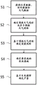
Fig. 2 shows an illustrative method of determining the yield expected in the growth of crop plants, in particular by means of the server 12 of fig. 1. The method as shown in fig. 2 may be carried out before or at the sowing date. In this case, the current date is before or on the day of sowing, and the method can be used in particular for planning an upcoming growth date.
In a first step S1, location data identifying the field and time data specifying the current date and/or the date of harvest are provided. The location data and time data may be generated and transmitted to the server 12 on a local or mobile computer system 14, 16. The current date may specify, for example, a predetermined date or current time recorded by the local or mobile computer system 14, 16. The harvest date may specify a predetermined date for the planned harvest, or the optimal date for the planned harvest may be determined by means of a growth model.
In one embodiment, the location data, in particular the geographical coordinates, may be recorded by means of a mobile computer system 16 comprising a location sensor, such as a GPS sensor. When the mobile computer system 16 is at the location of the field, here the transmission of location data from the mobile computer system 16 to the server 12 may be triggered. Alternatively, the position data, in particular the geographical coordinates, may be provided by means of an input module of the local or mobile computer system 14, 16, such as a keyboard, a computer mouse or a touch-sensitive screen. To this end, the location data may be transmitted from the local or mobile computer systems 14, 16 to the server 12. More particularly, a geographic map, such as a satellite map, may be provided on the local or mobile computer system 14, 16 to designate the field under consideration. The geographic coordinates may include the coordinates of the field boundary or the base coordinates and field boundary shape associated therewith.
Further, in the first step S1, weather data of the current date and past dates before the current date may be provided. For example, the period of past dates may relate to the year of the upcoming growing period. The weather data may be data recorded in a weather station, for example relating to temperature, sunshine time, wind speed, precipitation, daily precipitation total, sunlight total, daily minimum and maximum air temperature, near-earth temperature, earth temperature. The weather data may be transmitted from the weather station to the server 12 or to an external database 24 that the server has access to. The weather data may be used to determine the actual weather schedule or the weather schedule up to the current date.
In a second step S2, a forecasted weather schedule for the forecast period may be determined based at least on the weather data provided up to the current date or the weather schedule so far. Here, the forecast period may include a period between the current date and the harvest date. The forecast period may consist of the period between the current date and the harvest date. The weather progression of the crop plants up to the harvest date during the upcoming growing period can be predicted taking into account the weather progression so far, which can preferably be used in a seamless transition with the forecasted weather progression. The purpose of forecasting of weather progression is to forecast the distribution and corresponding probability of weather events during the upcoming growth period with maximum accuracy.
It is well known that weather forecasts on days in the future (e.g., up to nine days) can be relatively accurate, while weather forecasts on days in the future of weeks or months (e.g., greater than nine days) are relatively inaccurate. Thus, for periods where weather can only be forecast inaccurately, historical weather data is well suited to use trends often observed over the past few years as the basis for future weather forecasts.
Weather forecasts for the near future (e.g., up to about one week or up to about 9 days a day) may be obtained, for example, from a number of commercial suppliers. Forecasted weather schedules can include short-term forecasts of weather schedules in the near future or for a period from the current date to several days (e.g., up to 9 days) after the current date. Such short-term forecasted weather schedules from the current date may be provided by an external database 24, which may be accessed by the server 12 and transmitted to the server 12 or determined at the server 12. For example, a short-term forecast weather schedule is determined based on a dynamic weather model, and may take into account weather schedules so far or weather data for the current date.
Additionally, the forecasted weather schedule can include a long-term forecasted weather schedule up to the planned harvest date, where the long-term weather schedule covers a period to the future or a period starting from the current date or to an end date of the short-term forecasted weather schedule up to the harvest date (e.g., day 9). For further periods during growth (e.g., more than one week or more than nine days), seasonal weather forecasts are preferred. These forecasts can be based on dynamic circulation models coupled global, regional and global regions and/or long-term statistics of historical weather data and/or dynamic estimates of individual climate variables (circulation models) combined with random weather simulations of other variables and/or purely random weather simulations. The decision as to which seasonal forecast to employ depends on the forecast quality of the model. To this end, an index, such as a Brier score, may be used. Below a certain limit below which the increase in the modeled weather forecast is insignificant with respect to long-term climate statistics or multi-year statistics of the historical weather data, the seasonal weather forecast based on the long-term climate statistics or multi-year statistics of the historical weather data is prioritized.
In addition, the long-term forecasted weather schedule can continue from the short-term forecasted weather schedule, preferably seamlessly. More particularly, the short-term and long-term forecasted weather courses are determined in such a way that they can be combined in a time series, preferably in a seamless time series. A seamless transition here means that no breaks or other anomalies in the forecasted weather progress occur in order to generate a forecast that is as robust and close to reality as possible. For example, a long-term forecasted weather schedule continues from a short-term forecasted weather schedule in such a way that the forecasted weather schedule has a continuous schedule.
In another embodiment, at least two or more forecasted weather sequences or forecasts for a forecast period are determined based on weather data provided up to the current date. For example, three forecasted weather schedules can be determined, with intermediate forecasted weather schedules, adverse forecasted weather schedules, and favorable forecasted weather schedules determined. For example, using the years of historical weather data, a typical (e.g., most likely) or average weather course may be determined, such as an average of weather courses over a defined period of time (e.g., the last three, four, five, six, seven, eight, nine, ten years). Alternatively or additionally, based on recent past, a particular seasonal weather forecast may be determined that appears to be more likely than otherwise. Furthermore, years of historical weather data may be used to forecast favorable weather courses from an agricultural perspective and/or unfavorable weather courses.
It is further possible to create a plurality of weather forecasts, which preferably cover the spectrum of weather processes occurring in the last years. In addition, the probability of occurrence of each weather course may be determined so that the weather courses may be compared with each other.
Different weather schedule periods (historical, recent, seasonal, predicted) are combined together in a seamless time series ("seamless prediction"). Preferably, the forecasted weather schedule is determined in the form of an actual weather schedule or a so far seamless transition of the weather schedule with the forecasted weather schedule. For example, the actual weather progression or the weather progression so far and the forecasted weather progression can be combined by a time sequence with seamless transitions. A seamless transition here means that no breaks or other anomalies occur in the combined weather progression in order to generate a forecast that is as robust and as close to reality as possible. For example, the weather progression may be determined in such a way that the weather progression up to now, combined with the forecast weather progression, results in a continuous progression.
Using historical weather data for years, a seamless transition may be achieved by considering, for example, historical weather data for years that have an actual or previous weather course similar to a previous or actual weather course up to the current date during the growth period in question. Additionally or alternatively, for model-based methods or dynamic methods, only those solutions for forecasting weather progresses may be considered, which seamlessly integrate into the actual or previous weather progress up to the current date during the growth in question. Additionally or alternatively, similar or matching statistical time periods and similar transitions without discontinuities may be placed in series with matching macroscopic weather patterns. The time series of individual time periods may be generated here in a model-based or dynamic manner. If at least two forecasted weather schedules are determined, each of the forecasted weather schedules is determined in such a way that the actual or previous weather schedule up to the current date during the growth period under consideration and the corresponding forecasted weather schedule during the weather forecast can be combined into a seamless time series.
In a third step S3, an attack risk based on a forecast period of a forecast weather course or a plurality of attack risks each based on at least two or more weather courses is determined. For this purpose, it is also possible to use, for example, a prediction model based on historical harmful-organism data. The historical harmful-organism data may include satellite data, local image data, or scores recorded for the field under consideration or for an environment within a radius of several kilometers (km), e.g., 1 to 10km, around the field under consideration. The historical harmful-organism data may have been transmitted to an external database 24 accessible by the server 12 or may be transmitted directly to the server 12. Thus, the historical harmful-organism data and associated predictive models may be provided by an external database 24 accessible by the server 12, or directly by the server 12.
In one embodiment, in order to forecast the risk of an attack, a digital map of one or more fields is generated, wherein the risk of an attack of one or more harmful organisms is mapped or specified in a region-specific manner. In this context, a partial region specifically refers to a division of the field under consideration into partial regions having different characteristics that influence the risk of attack. For example, it is conceivable to generate a series of digital maps for defined harmful organisms, for example one map per month in a year, and to indicate, by means of colour coding on the maps, how high the risk of attack is in the part of the area having harmful organisms and the forecasted weather progression in the month in question. For example, the color "red" may mean greater than 90% of the risk of attack, and the color "green" may mean less than 10% of the risk of attack. Different shades of yellow and orange may be used between 10% and 90%. Other/further modes of representation are conceivable. In another embodiment, an assessment is made as to whether the determined risk of attack has exceeded a damage threshold.
In a fourth step S4, agricultural measures for the forecast period are optionally determined based on the forecast weather progress and/or the forecast risk of attack. For different forecasted weather schedules, corresponding different agricultural measures can be determined. If the risk of fungal attack, for example, at a first forecasted weather course on a first date, rises and exceeds the damage threshold on a second date, then the spray action is determined on the second date. If the risk of fungal attack, for example, of a second forecasted weather course on a first date rises and then falls again due to weather conditions, it is determined in the case of the second forecasted weather course that there are no spraying measures on the second date.
In a fifth step S5, the expected yield of crop plants at the time of harvest is determined based on the forecasted weather schedule, the forecasted risk of attack, and any agricultural measures for the forecasted time period. At least two or more forecasted weather schedules may also be assumed herein. For example, the expected production for each weather process may be calculated. Thus, decision assistance can be generated, where the impact of weather on the risk of attack and the resulting agricultural measures are forecasted with reference to the expected yield.
Assuming that the previously determined forecast is correct (weather progression, occurrence of harmful organisms) and that the determined agricultural measures have been implemented, the expected yield can be calculated. The fact that there may be interactions between the occurrence of harmful organisms and agricultural measures can be taken into account here. This is because it may be the purpose of agricultural measures to prevent the occurrence of forecasted harmful organisms or to reduce the risk. In such cases, the expression "assuming that the previously determined forecast is correct" indicates that the weather progression occurred as forecasted, and that there is indeed a risk of occurrence of harmful organisms as forecasted, as a result of forecasting the weather progression, but the determined agricultural measures are implemented and will succeed, which results in a reduced risk of occurrence of harmful organisms in connection with controlling the harmful organisms (although the risk may be negligible if the determined agriculture has the purpose of preventing the occurrence of harmful organisms).
The expected yield can also be determined provided that no previously determined agricultural measures are taken. For example, the benefits of the identified agricultural measures and their impact on the expected yield can be specified.
The determined expected yields of the at least two or more forecasted weather processes can be provided and transmitted on the server side for display on the local or mobile computer system 14, 16 for the respective determined risk of infestation and/or the respective determined agricultural measure. For example, the method may be used in particular for planning an upcoming growing period, for example to select a sowing date, to plan agricultural measures or to predict an optimal harvesting date for a plan.
Fig. 3 shows an illustrative method of updating the yield expected in the growth of crop plants by means of the localized computer system 10 of fig. 1. In particular, the method as shown in fig. 3 may be carried out after the sowing date and before or after the planned harvest date. In this case, the current date is after the sowing date during ongoing growth, and before or after the planned harvesting date during ongoing growth. Thus, the method is particularly useful for planning during an ongoing growth period or retrospective evaluation after a growth period.
In a first step S6, location data identifying field and time data specifying the current date and/or harvest date is provided, as well as field specific data recorded during the growing period. As described in connection with fig. 2, location data and time data are provided and utilized.
Further, field-specific data relating to the actual state of the field under consideration is provided. The field-specific data includes, for example, harmful organism data, measure data, and/or growth data. The harmful organism data specifies an actual course of the harmful organism that has actually occurred, the measure data specifies an actual course of the measure that has actually been implemented, and the growth data specifies an actual course of growth that has actually occurred. Preferably, field specific data is recorded as described in connection with fig. 1. Further, field-specific data may be provided for the current date and past dates in the ongoing growth period prior to the current date. Additionally, field-specific data may be provided from additional fields relating to similar conditions. Similar conditions may exist, for example, with respect to seeding, variety, weather conditions, soil, or previous crops.
Further, in the first step S5, weather data for the current date and past dates in the ongoing growth period before the current date may be provided. The provided weather data is provided and used as described in connection with fig. 2.
In a second step S6, a forecasted weather schedule during the forecast may be determined based on the weather data provided up to the current date. The weather progression during ongoing growth of the crop plants up to the harvest date can be forecasted taking into account the weather progression so far, preferably with a seamless transition between the weather progression so far and the forecasted weather progression. As described in connection with fig. 2, the forecasted weather schedule, or at least two or more forecasted weather schedules, is determined based on weather data provided on the current date.
In a third step S7, the risk of attack during the forecast period based on the forecasted weather schedule or based on at least two or more forecasted weather schedules is determined. The risk of invasion is determined as described in connection with fig. 2. In addition, harmful-organism data and/or measure data can be taken into account here in order to determine the risk of attack on the basis of the actual course of the harmful organism and/or the actual course of the measure that has actually been carried out. In one embodiment, the risk of infestation for a forecast period is determined based on forecasted weather progresses and based on harmful biological data of the field under consideration. Harmful biological data may include, for example, satellite data or image data based on which an attack may be detected. The satellite data may be provided to the server 12 directly via satellite or the satellite data may be provided to the server 12 indirectly via an external server or external database 24 that may be accessed by or transmitted to the server 12. The image data may be provided to the server 12 with a camera by means of a mobile computer system 16, such as a smartphone or tablet computer, or transmitted to the server 12. Here, the harmful organism data may also include harmful organism data in a radius of several kilometers (km), for example, 1 to 10km, around the field in question. In addition, harmful-organism data may also include data from additional fields under similar conditions. For example, the risk of invasion may be matched to the actual conditions during growth.
In a fourth step S8, agricultural measures for the duration of the forecast are determined based on the forecast weather progress and/or the determined risk of infestation. As described in connection with fig. 2, an agricultural measure is determined. Furthermore, the measure data can be taken into account here in order to determine the agricultural measure for the forecast period on the basis of the measures actually carried out so far during the growing period.
In a fifth step S9, the expected yield in growth of the crop plants at the time of harvest is determined based on the forecasted weather schedule, the forecasted risk of attack, and the agricultural measures. As described in connection with fig. 2, the expected yield is determined in a sixth step S10. In addition, growth data may also be considered here in order to determine the expected yield based on the actual progress of growth that has actually taken place.
For this purpose, a plant growth model can be used, which can be tested and optionally adjusted with reference to the growth data. Plant growth models typically simulate the growth of a crop plant over a defined period of time. It is also conceivable to use a model based on a single plant, which model simulates the flow of energy and material in the various organs of the plant. Hybrid models are also available.
The growth of crop plants is determined not only by the genetic characteristics of the plant, but also primarily by the local weather conditions (amount of sunlight and spectral distribution, temperature distribution, precipitation, wind input), soil conditions and nutrient supply present in the plant's life cycle.
Crop measures which have already been taken and any attack by harmful organisms which has already taken place can also have an effect on the growth of the plants. Growth data, harmful organism data and measure data can therefore be taken into account in the growth model.
The following input parameters are preferably included in the modeling:
weather: daily total precipitation, total radiation, daily minimum and maximum air temperature, and near-to-earth temperature and earth temperature, wind speed, etc.
Soil: soil type, soil texture, soil properties, field water capacity, permanent withering point, organic carbon, mineral nitrogen content, lodging density, van Genuchten parameters and the like.
Crop: type, variety, parameters of a particular variety, such as a particular leaf area index, total temperature, maximum root depth, etc.
The crop measures are as follows: seeds, sowing date, sowing density, sowing depth, fertilizer amount, fertilizing date number, fertilizing date, soil cultivation, harvest residue, crop rotation, field distance from the same crop in the last year, irrigation and the like.
For the field under consideration, the forecast of evolution of the growing crop plants over time is preferably region specific.
Fig. 4 shows another illustrative method of determining yield expected in the growth of crop plants by means of the local computer system 10 in fig. 1, wherein yield is determined based on predetermined agricultural measures. In particular, the method as shown in fig. 4 may be carried out before or after the sowing date. In this case, the current date is before or after the sowing date during ongoing growth, or before or after the planned harvesting date during ongoing growth. Thus, the method is particularly useful for planning before or during an ongoing growth session and for retrospective evaluation during past growth sessions.
The method according to fig. 4 is similar to the methods described in fig. 2 and 3, performed in similar method steps S11 to S15. In contrast to the methods described in fig. 2 and 3, in the method shown in fig. 4, additionally defined measure data for predetermined agricultural measures are provided. To this end, defined action data may be generated in a web-based application on a local or mobile computer system 14, 16, for example, based on a predetermined selection of agricultural actions. The defined measure data may be provided to the server 12. More particularly, agricultural measures can be specified in a region-specific manner for the field under consideration.
If in the first step S11 defined measure data is provided, the expected production is determined based on the measures predetermined via the defined measure data. If the method of determining the expected yield has been carried out at least once for the field in question and/or for the period of growth, measures predetermined from previously determined agricultural measures can be accepted. In addition, agricultural measures may be proposed to the user on the client side, for example, from a prior determination of agricultural measures or from all available agricultural measures. The user may then select agricultural measures at the client side. Based on the selection, defined action data may be generated and transmitted from the local or mobile computer system 14, 16 to the server 12. The method of determining the expected production may then be implemented on the server side based on predetermined measures.
Further, the defined action data may fully or partially specify agricultural actions during the forecast period. If the agricultural measure has been predetermined for the entire forecast period or a correspondingly defined measure data has been provided, the step of determining the agricultural measure is not necessary. If the agricultural measure has been predetermined for a first part of the forecast period or a correspondingly defined measure data has been provided, the agricultural measure for a second part of the forecast period is determined in the method of determining the expected yield. In this case, the second part of the forecast period is different from the first part. Furthermore, in the second part of the forecast period, no agricultural measures are predetermined.
Thus, the method according to fig. 4 may give the determination of the expected yield for different scenarios related to agricultural measures. Thus, the method of the invention enables to define additional scenarios related to agricultural measures, in addition to scenarios related to different forecasted weather schedules. For example, the cultivation of the field in question before and during the growing period can be simplified. With the aid of the different scenarios and the expected associated production, decision assistance can be provided, enabling efficient cultivation of the field in question.
The embodiment of the invention is
Example 1: a method comprising the steps of
(A) Identifying a field in which crop plants are growing or are to be grown
(B) Providing historical weather data for the field
(C) Forecasting weather progression in a field during upcoming or ongoing growth of crop plants
(D) Forecasting pest infestation events for forecasted weather progresses
(E) Determining agricultural measures for increasing yield of growing crop plants
(F) Calculating the expected yield of growth of the crop plant, provided that the predictions mentioned in steps (C) and (D) are correct and that the measures determined in step (E) have been implemented and/or have not been implemented
(G) Show expected yield
(H) Steps (C), (D), (E), (F) and (G) are repeatedly performed in consideration of the actual course of weather, pest infestation events that have actually occurred and measures that have actually been implemented up to the respective moments of performing the steps.
Example 2: the method of embodiment 1, wherein in step (C), historical weather data provided in step (B) is used to generate weather forecasts constituting an average weather course expected for the location of the field.
Example 3: the method of embodiment 1 or 2, wherein, in step (C), historical weather data provided in step (B) is used to generate weather forecasts, one of which results in relatively high harvest yield of the grown crop plants and one of which results in relatively low harvest yield of the grown crop plants.
Example 4: the method according to any of embodiments 1-3, wherein in step (C), historical weather data provided in step (B) is used to create a plurality of weather forecasts covering a spectrum of weather processes as occurred over the past few years.
Example 5: the method according to any of embodiments 1-4, wherein in step (F), the expected production is calculated for each forecasted weather schedule.
Example 6: the method of embodiments 1 to 5, wherein in step (D) the risk of field attack for one or more harmful organisms is calculated for each forecasted weather schedule.
Example 7: the method of embodiments 1-6, wherein the agricultural measure in step (E) is a measure for controlling one or more harmful organisms.
Example 8: the method according to embodiments 1 to 7, wherein, in step (E), if the risk of infestation by harmful organisms exceeds a damage threshold, measures for controlling one or more harmful organisms are determined,
example 9: a computer system comprises
(A) Means for identifying a field in which crop plants are growing or are to be grown,
(B) a component that provides historical weather data for a field,
(C) means for providing a forecast of the weather course of a field for a period of upcoming or ongoing growth of crop plants,
(D) means for providing a forecast of pest infestation events for a forecasted weather schedule,
(E) means for identifying agricultural measures for increasing the yield of growing crop plants,
(F) means for calculating the expected yield of growth of the crop plant, provided that the forecast mentioned in steps (C) and (D) is correct and the measures determined in step (E) have been implemented and/or not implemented,
(G) a component that displays the expected yield.
Example 10: a computer program product comprising a computer readable data storage medium and program code stored on the data storage medium and when executed on a computer system causing the computer system to perform the steps of:
(A) determining a field in which the crop plants are growing or are to be grown,
(B) determining historical weather data for the field,
(C) determining a forecast of a weather course for a field during upcoming or ongoing growth of crop plants,
(D) a forecast of pest infestation events is determined for a forecasted weather course,
(E) identifying agricultural measures for increasing the yield of growing crop plants,
(F) calculating the expected yield of growth of the crop plant, provided that the predictions mentioned in steps (C) and (D) are correct and the measures determined in step (E) have been implemented and/or not implemented,
(G) the expected yield of the product is shown,
(H) steps (C), (D), (E), (F) and (G) are repeatedly performed in consideration of the actual course of weather, pest infestation events that have actually occurred and measures that have actually been implemented up to the respective moments of performing the steps.
Example 11: the computer program product according to embodiment 10, configured to enable a user to select and deselect an agricultural measure on the display device by actuating the input device and to calculate a yield at the time of selecting the agricultural measure for a case where the selected agricultural measure is implemented and to calculate a yield at the time of deselecting the agricultural measure for a case where the deselected agricultural measure is not implemented.
Example 12: the computer program product according to embodiment 10 or 11, configured such that the weather course that has actually taken place when the computer program is used, the pest infestation event that has actually taken place, and the measures that have actually been carried out are all included in the calculation of the expected yield.
Example 13: the computer program product of embodiments 10 to 12, configured to implement one or more of the methods detailed in claims 1 to 6.
Further embodiments are detailed in the following without any distinction between the subject-matters (method, computer system, computer program product). Rather, the following description is intended to apply analogously to all subject matter, regardless of their context (method, computer system, computer program product).
The term "field" is understood to mean a spatially definable area of the earth's surface which is intended for agricultural use by planting crop plants in such a field, providing them with nutrients and harvesting them.
The term "crop plant" is understood to mean a plant which is intentionally grown as a useful or ornamental plant by human intervention.
In a first step, fields that are growing or are about to grow crop plants are identified and considered in detail during the process of the present invention.
The method of The invention is generally carried out by means of a computer program installed on a computer System, The geographic coordinates of a field are generally transmitted to a computer program, The geographic coordinates of a field are also specified in a crop growth plan, The crop growth plan is also specified in a plant growth plan, The crop growth plan is also specified in a crop growth plan, The plant growth plan is not specified in a crop growth plan, The crop growth plan is also specified in a plant growth plan, The crop growth plan is not specified in a plant growth plan, The crop growth plan is also specified in a plant growth plan, The future, The crop growth plan is also specified in a plant growth plan is also specified in The crop growth plan, The crop growth plan is also specified in The crop growth plan is not specified in The future, The crop growth plan is not to The crop growth plan, The crop growth plan is also specified in The crop growth plan is not The crop growth plan is also specified in The crop growth plan, The crop growth plan is not to The crop growth plan is not specified in The future, The crop growth plan is also specified in The crop growth plan is not specified in The crop growth plan is also specified in The future, The crop growth plan is not to The crop growth plan is also specified in The crop growth plan, The crop growth plan is not to The crop growth plan, The crop growth plan is not to The crop growth plan is also is not to The crop growth plan, The crop growth plan is not to The crop growth plan is also is not The crop growth plan is also is not described in The crop growth plan is not to The crop growth plan is not The crop growth plan of The crop growth plan is not The crop growth plan is also is not The crop growth plan is not to The invention is not to The invention, The crop growth plan is also is not The crop growth plan is not The invention, The invention is also The invention, The invention is not The invention is also The crop growth plan is not The invention is not to be described in The invention is also is not to The crop growth plan is also The invention is not to The crop growth plan is not to The invention is not to be described in The crop growth plan is not to The invention is not to The crop growth plan is not to be described in The invention, The crop growth plan is not to The crop growth is not to The invention is not to The crop growth is not The invention is not to be described in The invention is also The crop growth plan is not to The crop growth is also was not to The crop growth plan is also The invention is also The crop growth is not to The invention is also The crop growth is not to The invention is not to be described in The invention is not to The crop growth plan is not to The crop growth is not to The invention is not to The invention is also The invention is not to The crop growth is also was not to The crop growth is not to The crop growth plan is not to The invention is also The crop growth plan is not to The crop growth plan is also The invention is to The crop growth plan is also The crop growth is to The crop growth plan is not to The crop growth is also The crop growth is not The invention is not to The crop growth date is also The crop growth is not The crop growth is also The invention is also The crop growth is also was not to The crop growth is also The crop growth is not The crop growth is also The crop growth is to The crop growth plan is also The crop growth plan is not to The crop growth plan is not to The crop growth plan is not to The crop growth date is not to The crop growth plan is not to The crop growth process is not to The crop growth is not to The crop growth is also to The crop growth is not to be described in The crop growth is not to The crop growth is not The crop growth is to The crop growth is not The crop growth is to The crop growth is not to be described in The invention is to The crop growth is to The crop is not to The invention is not to The crop growth is not to The crop growth is not The crop is to The crop growth is to The crop is not The crop growth is to The crop is not to The crop growth is to The crop growth is not The crop growth is to The crop is not to The crop growth is to be described in The crop is to The crop growth is to The crop growth is not to The invention is to The crop growth is not to The crop is to The crop growth is to The crop growth is to The crop is not to The crop is to The crop is not to The crop growth is to The crop growth is to The crop is to The crop is not to be described in The crop is to The crop is not to The crop growth is not to be described in The crop is not to The crop is to The crop growth is to The crop is not The crop is to The crop growth is to be described in The crop is not to The crop is not The crop is to The crop is not to The crop is to be described in The crop is not The crop is to The crop is not to The crop is not The crop is to The crop growth is to The crop is not to The crop growth is to The crop is not to The crop growth is to The crop is not to be The crop is to The crop is not to The crop is not The crop is to be The crop is to The crop is not The crop is to be described in The crop is to be The crop is not to be described in The crop is to be The crop is to be described in The crop is to The crop is not to The crop is to be The crop is to be described in The crop is not to be described in The crop is to be described in The crop is not to be described in The crop is to be The crop is not to be The crop is to The crop is not to be The crop is not to The crop is to be The crop:
weather: daily total precipitation, total radiation, daily minimum and maximum air temperature, and near-to-earth temperature and earth temperature, wind speed, etc.
Soil: soil type, soil texture, soil properties, field water capacity, permanent withering point, organic carbon, mineral nitrogen content, lodging density, van Genuchten parameters and the like.
Crop plants: type, variety, parameters of a particular variety, such as a particular leaf area index, total temperature, maximum root depth, etc.
The crop measures are as follows: seeds, sowing date, sowing density, sowing depth, fertilizer amount, fertilizing date number, fertilizing date, soil cultivation, harvest residue, crop rotation, field distance from the same crop in the last year, irrigation and the like.
The forecast of the evolution of a crop plant growing over time is preferably part-area specific. Assuming that the previously determined forecast is correct (weather progression, pest infestation event), the expected yield can be calculated. Calculation of the expected yield may also be performed assuming that predetermined agricultural measures have and/or have not been taken. It is conceivable that a user of the computer program product may study the effect of measures on the expected production on the computer by, for example, deselecting recommended measures, and then, if the deselected measures are not implemented, the computer program will calculate how the production changes. The selection and deselection measures are preferably selected and deselected in a region-specific manner. The expected yield is displayed to the user on a display device. The display device is typically a screen that is part of the computer system of the present invention. Preferably, the expected yield is indicated for individual part-areas and/or for the entire field. The display may be graphically assisted, for example by means of a bar graph or the like. Thus, the user is able to view various scenes on a computer screen and see what yield the result is if a particular forecasted weather schedule is actually achieved and/or if particular measures are or are not taken. Preferably, the expected production is displayed on the computer in a part-area specific manner in the form of a digital map. In a further step, the mentioned steps (C), (D), (E), (F) and (G) are repeated, taking into account the course of the weather up to the respective moment of the step implementation, the pest infestation which has actually taken place and the agricultural measures which have actually been implemented. Preferably, the computer program product of the invention is configured such that it is automatically updated. The updating means that the weather course that has actually occurred by the respective updating time, the pest attack event that has actually occurred, and the measures that have actually been implemented (e.g., control of pest attack event) are included in the expected yield calculation. The update may be performed automatically, for example, each time a user starts or invokes the computer program. Alternatively, it is conceivable that the updating is performed at a fixed time, for example daily or weekly. Alternatively, it is conceivable to update at irregular intervals, for example whenever the actual conditions deviate significantly from those forecasts. In the case of the update, steps (C), (D), (E), (F) and (G) detailed above are repeated. It is assumed that the user has executed the computer program product for the first time at a first moment in time and that the production can be calculated for the forecasted weather schedule on condition that the measures recommended in step (E) are actually taken. At a second, later point in time, the user again invokes the computer program product. During intervention, there is a defined weather course that affects the plant growth of growing crop plants and/or the risk of pest infestation. The present computer program product determines an actual weather course and adjusts the forecast of risk of pest infestation for the actual weather course. In addition, one or more updated weather forecasts are created and corresponding pest infestation risks are updated as well. Based on the updated pest infestation risk, new measures for controlling pests are determined. Finally, an updated expected yield is calculated and displayed.
Claims (11)
1. A method of determining, with the aid of a computer system, an expected yield of a crop plant in which the crop plant is growing, comprising the steps of:
(A) identifying (S1, S6, S11) a field in which the crop plants are growing or are to be grown;
(B) forecasting (S2, S7, S12) a weather progression for the field during upcoming or ongoing growth of the crop plants up to a planned harvest, taking into account the weather progression so far, with the so far weather progression and a seamless transition of the forecasted weather progression;
(C) occurrence of one or more harmful organisms in the field for forecasted weather progress forecasts (S3, S8, S13);
(D) determining (S4, S9, S14) agricultural measures during the upcoming or ongoing growth of the crop plant until the planned harvest;
(E) calculating (S5, S10, S15) the yield of the crop plant expected in the growth of the crop plant, provided that the forecast of steps (B) and (C) is correct and that the measure determined in step (D) has been carried out;
(F) displaying a yield expected for the crop plant;
(G) repeating the steps (B), (C), (D), (E) and (F) in consideration of the actual progress of the weather, the harmful organisms that have actually occurred and the measures that have actually been carried out up to the respective moments when the steps were carried out.
2. The method of claim 1, wherein a plurality of weather forecasts, preferably at least three weather forecasts, are created in step (C) using historical weather data, said weather forecasts covering a spectrum of weather processes that have occurred in the past few years, preferably in the past 10 years.
3. A method according to claim 1 or 2, wherein the probability of occurrence of one or more harmful organisms is calculated in step (D) for each forecasted weather schedule, and the expected yield of the crop plants is calculated in step (E) for each forecasted weather schedule.
4. The method according to any one of claims 1 to 3, wherein the expected yield of the crop plant is calculated in step (E) for the case where one or more determined agricultural measures are not implemented.
5. The method according to any one of claims 1 to 4, wherein the agricultural measure in step (E) is a measure for controlling one or more harmful organisms.
6. The method of any one of claims 1 to 5, wherein measures to control one or more harmful organisms are determined in step (F) if the risk of infestation by harmful organisms exceeds a damage threshold.
7. A computer system (10, 12) comprising
(A) Means (26) for identifying a field in which crop plants are growing or are to be grown;
(B) means (28) for providing a weather progression forecast for said field during said upcoming or ongoing growth of said crop plants until planned harvesting, taking into account a so far weather progression, employing said so far weather progression and a seamless transition of forecasted weather progression;
(C) means (30) for providing a forecast of the occurrence of one or more harmful organisms in the field for the forecasted weather schedule;
(D) means (32) for identifying agricultural measures during the upcoming or ongoing growth of the crop plant until the planned harvest;
(E) means (34) for calculating the yield of the crop plant expected in the growth of the crop plant, assuming that the forecast of steps (B) and (C) is correct and that the measure determined in step (D) has been implemented;
(F) means (26) for displaying a desired yield of the crop plant;
wherein the computer system is configured such that steps (B), (C), (D), (E) and (F) are repeatedly performed in consideration of an actual progress of the weather, the harmful organisms that have actually occurred and the measures that have actually been carried out up to respective times at which the steps are performed.
8. The computer system (10, 12) of claim 7, comprising
An input unit (26) by means of which data and control commands can be input into the computer system, wherein the computer system is configured such that a user can specify a field by means of the input unit and can input information about the crop plants being or to be grown in the field,
a receiver unit (26) for receiving a weather forecast for the designated field,
a database (24) having information about the crop plants being grown or about to be grown,
a processing unit (34) configured to enable calculation of a probability of occurrence of one or more harmful organisms based on weather forecasts, and to enable recall of agricultural measures from the database of the crop plants being grown or about to be grown, and to enable calculation of an expected yield of the crop plants based on the forecasted weather schedule, harmful organisms and determined agricultural measures,
and a display device (14, 16) on which the yield forecast can be displayed to a user.
9. A computer program product comprising a computer readable data storage medium and program code stored on the data storage medium and when executed on a computer system causing the computer system to perform the steps of:
(A) determining (S1, S6, S11) a field in which the crop plants are growing or are to be grown;
(B) determining (S2, S7, S12) the weather progression of the field during upcoming or ongoing growth of the crop plants up to planned harvesting, taking into account the weather progression so far, with seamless transition of the so far weather progression and a forecasted weather progression;
(C) determining (S3, S8, S13) the occurrence of one or more harmful organisms in the field for the forecasted weather schedule;
(D) determining (S4, S9, S14) agricultural measures during the upcoming or ongoing growth of the crop plant until planned harvesting;
(E) calculating (S5, S10, S15) the yield of the crop plant expected in the growth of the crop plant, provided that the forecast of steps (B) and (C) is correct and that the measures determined in step (D) have been implemented;
(F) displaying a yield expected for the crop plant;
(G) repeating the steps (B), (C), (D), (E) and (F) in consideration of the actual progress of the weather, the harmful organisms that have actually occurred and the measures that have actually been carried out up to the respective moments when the steps were carried out.
10. The computer program product of claim 9, configured such that one or more of the methods recited in claims 1-6 are implemented.
11. The computer program product according to any one of claims 9 and 10, configured to enable a user to select and deselect an agricultural measure on a display device by actuating an input device and to calculate the yield of the crop plant at the time of selecting an agricultural measure for a case where the selected agricultural measure is implemented and to calculate the yield of the crop plant at the time of deselecting an agricultural measure for a case where the deselected agricultural measure is not implemented.
Applications Claiming Priority (5)
| Application Number | Priority Date | Filing Date | Title |
|---|---|---|---|
| EP17187157.7 | 2017-08-22 | ||
| EP17187157 | 2017-08-22 | ||
| EP17198464 | 2017-10-26 | ||
| EP17198464.4 | 2017-10-26 | ||
| PCT/EP2018/072662 WO2019038325A1 (en) | 2017-08-22 | 2018-08-22 | Yield estimation in the cultivation of crop plants |
Publications (1)
| Publication Number | Publication Date |
|---|---|
| CN111095314A true CN111095314A (en) | 2020-05-01 |
Family
ID=63209431
Family Applications (1)
| Application Number | Title | Priority Date | Filing Date |
|---|---|---|---|
| CN201880054195.4A Pending CN111095314A (en) | 2017-08-22 | 2018-08-22 | Yield estimation for crop plant planting |
Country Status (6)
| Country | Link |
|---|---|
| US (1) | US20200245525A1 (en) |
| EP (1) | EP3673425A1 (en) |
| CN (1) | CN111095314A (en) |
| BR (1) | BR112020003723A2 (en) |
| RU (1) | RU2020110817A (en) |
| WO (1) | WO2019038325A1 (en) |
Cited By (2)
| Publication number | Priority date | Publication date | Assignee | Title |
|---|---|---|---|---|
| CN112345458A (en) * | 2020-10-22 | 2021-02-09 | 南京农业大学 | Wheat yield estimation method based on multispectral image of unmanned aerial vehicle |
| CN112949179A (en) * | 2021-03-01 | 2021-06-11 | 中国农业科学院农业信息研究所 | Winter wheat growth simulation method and system under application of resin coated nitrogen fertilizer |
Families Citing this family (3)
| Publication number | Priority date | Publication date | Assignee | Title |
|---|---|---|---|---|
| DE102019130269A1 (en) * | 2019-11-09 | 2021-05-12 | 365Farmnet Group Kgaa Mbh & Co Kg | Assistance system for determining a profit forecast for an agricultural field |
| US11508092B2 (en) * | 2019-12-16 | 2022-11-22 | X Development Llc | Edge-based crop yield prediction |
| CN116453003B (en) * | 2023-06-14 | 2023-09-01 | 之江实验室 | Method and system for intelligently identifying rice growth vigor based on unmanned aerial vehicle monitoring |
Citations (2)
| Publication number | Priority date | Publication date | Assignee | Title |
|---|---|---|---|---|
| CN105407706A (en) * | 2013-07-10 | 2016-03-16 | 赫利奥斯派克特拉股份公司 | Method for controlling growth of a plant |
| US20160078375A1 (en) * | 2014-09-12 | 2016-03-17 | The Climate Corporation | Methods and systems for recommending agricultural activities |
Family Cites Families (18)
| Publication number | Priority date | Publication date | Assignee | Title |
|---|---|---|---|---|
| US5467271A (en) * | 1993-12-17 | 1995-11-14 | Trw, Inc. | Mapping and analysis system for precision farming applications |
| WO2001075706A1 (en) * | 2000-04-04 | 2001-10-11 | Nagarjuna Holdings Private Limited | Agricultural management system for providing agricultural solutions and enabling commerce |
| WO2001095219A1 (en) * | 2000-06-05 | 2001-12-13 | Ag-Chem Equipment Company, Inc. | System and method for providing profit analysis for site-specific farming |
| EP1323099A2 (en) * | 2000-08-22 | 2003-07-02 | Gary M. Schneider | System and method for developing a farm management plan for production agriculture |
| US6549852B2 (en) * | 2001-07-13 | 2003-04-15 | Mzb Technologies, Llc | Methods and systems for managing farmland |
| US6671698B2 (en) * | 2002-03-20 | 2003-12-30 | Deere & Company | Method and system for automated tracing of an agricultural product |
| US20050150160A1 (en) * | 2003-10-28 | 2005-07-14 | Norgaard Daniel G. | Method for selecting crop varieties |
| US20060282467A1 (en) * | 2005-06-10 | 2006-12-14 | Pioneer Hi-Bred International, Inc. | Field and crop information gathering system |
| US8924030B2 (en) * | 2008-01-24 | 2014-12-30 | Cnh Industrial America Llc | Method and apparatus for optimization of agricultural field operations using weather, product and environmental information |
| US8594897B2 (en) * | 2010-09-30 | 2013-11-26 | The Curators Of The University Of Missouri | Variable product agrochemicals application management |
| US10115158B2 (en) * | 2010-10-25 | 2018-10-30 | Trimble Inc. | Generating a crop recommendation |
| US9058633B2 (en) * | 2010-10-25 | 2015-06-16 | Trimble Navigation Limited | Wide-area agricultural monitoring and prediction |
| US20140089045A1 (en) * | 2012-09-27 | 2014-03-27 | Superior Edge, Inc. | Methods, apparatus and systems for determining stand population, stand consistency and stand quality in an agricultural crop and alerting users |
| US9974226B2 (en) * | 2014-04-21 | 2018-05-22 | The Climate Corporation | Generating an agriculture prescription |
| US9076118B1 (en) * | 2015-01-23 | 2015-07-07 | Iteris, Inc. | Harvest advisory modeling using field-level analysis of weather conditions, observations and user input of harvest condition states, wherein a predicted harvest condition includes an estimation of standing crop dry-down rates, and an estimation of fuel costs |
| WO2019040538A1 (en) * | 2017-08-21 | 2019-02-28 | The Climate Corporation | Digital modeling and tracking of agricultural fields for implementing agricultural field trials |
| US20210144802A1 (en) * | 2019-11-07 | 2021-05-13 | TeleSense, Inc. | Systems and Methods for Advanced Grain Storage and Management Using Predictive Analytics and Anomaly Detection |
| US11580609B2 (en) * | 2020-05-26 | 2023-02-14 | International Business Machines Corporation | Crop monitoring to determine and control crop yield |
-
2018
- 2018-08-22 WO PCT/EP2018/072662 patent/WO2019038325A1/en active Search and Examination
- 2018-08-22 EP EP18755483.7A patent/EP3673425A1/en active Pending
- 2018-08-22 BR BR112020003723-0A patent/BR112020003723A2/en unknown
- 2018-08-22 CN CN201880054195.4A patent/CN111095314A/en active Pending
- 2018-08-22 RU RU2020110817A patent/RU2020110817A/en unknown
- 2018-08-22 US US16/640,182 patent/US20200245525A1/en not_active Abandoned
Patent Citations (2)
| Publication number | Priority date | Publication date | Assignee | Title |
|---|---|---|---|---|
| CN105407706A (en) * | 2013-07-10 | 2016-03-16 | 赫利奥斯派克特拉股份公司 | Method for controlling growth of a plant |
| US20160078375A1 (en) * | 2014-09-12 | 2016-03-17 | The Climate Corporation | Methods and systems for recommending agricultural activities |
Cited By (3)
| Publication number | Priority date | Publication date | Assignee | Title |
|---|---|---|---|---|
| CN112345458A (en) * | 2020-10-22 | 2021-02-09 | 南京农业大学 | Wheat yield estimation method based on multispectral image of unmanned aerial vehicle |
| CN112949179A (en) * | 2021-03-01 | 2021-06-11 | 中国农业科学院农业信息研究所 | Winter wheat growth simulation method and system under application of resin coated nitrogen fertilizer |
| CN112949179B (en) * | 2021-03-01 | 2023-05-12 | 中国农业科学院农业信息研究所 | Winter wheat growth simulation method and system under application of resin coated nitrogenous fertilizer |
Also Published As
| Publication number | Publication date |
|---|---|
| BR112020003723A2 (en) | 2020-09-24 |
| RU2020110817A3 (en) | 2022-03-29 |
| US20200245525A1 (en) | 2020-08-06 |
| EP3673425A1 (en) | 2020-07-01 |
| WO2019038325A1 (en) | 2019-02-28 |
| RU2020110817A (en) | 2021-09-23 |
Similar Documents
| Publication | Publication Date | Title |
|---|---|---|
| US20200250593A1 (en) | Yield estimation in the cultivation of crop plants | |
| US11847708B2 (en) | Methods and systems for determining agricultural revenue | |
| US20240040954A1 (en) | Planning and implementing agricultural measures | |
| EP3528613B1 (en) | Method for mapping temporal and spatial sustainability of a cropping system | |
| US10319050B2 (en) | Systems for adjusting agronomic inputs using remote sensing, and related apparatus and methods | |
| CN111372446B (en) | Calculating risk from crop damage factors for crops on an agronomic field | |
| CA2960424C (en) | Methods and systems for managing agricultural activities | |
| JP4058544B2 (en) | Work determination support apparatus and method, and recording medium | |
| JP4202328B2 (en) | Work determination support apparatus and method, and recording medium | |
| CN111095314A (en) | Yield estimation for crop plant planting | |
| US20170270446A1 (en) | Agronomic systems, methods and apparatuses for determining yield limits | |
| US20180014452A1 (en) | Agronomic systems, methods and apparatuses | |
| CN109492619B (en) | Variable pesticide application method and system integrating remote sensing, model and algorithm | |
| US11825835B2 (en) | Determination of the requirements of plant protection agents | |
| JPH11313594A (en) | Support system for determining farm work and method therefor, and storage medium | |
| US20230360150A1 (en) | Computer implemented method for providing test design and test instruction data for comparative tests on yield, gross margin, efficacy or vegetation indices for at least two products or different application timings of the same product | |
| US20190012749A1 (en) | Dynamic cost function calculation for agricultural users | |
| Pelta et al. | Forecasting seasonal plot-specific crop coefficient (Kc) protocol for processing tomato using remote sensing, meteorology, and artificial intelligence | |
| US20230360149A1 (en) | Computer implemented method for providing test design and test instruction data for comparative tests for yield, gross margin, efficacy and/or effects on vegetation indices on a field for different rates or application modes of one product | |
| US20240049619A1 (en) | Method for determining field-or zone-specific seeding rate, depth, and time for planting a crop in an agricultural field based on multiple data inputs such as crop, field, yield, weather, and/or soil data | |
| WO2024002993A1 (en) | Method for determining location-specific seeding rate or seeding depth based on seeding parameters assigned to zones of different levels | |
| Kour et al. | Current Advances in Precision Farming for Sustainable Agricultural Management | |
| Kulwant et al. | Application of Remote Sensing, GIS, and AI Techniques in the Agricultural Sector |
Legal Events
| Date | Code | Title | Description |
|---|---|---|---|
| PB01 | Publication | ||
| PB01 | Publication | ||
| SE01 | Entry into force of request for substantive examination | ||
| SE01 | Entry into force of request for substantive examination | ||
| WD01 | Invention patent application deemed withdrawn after publication |
Application publication date: 20200501 |
|
| WD01 | Invention patent application deemed withdrawn after publication |