CN109613552B - Detection and analysis method for TLS multi-echo point cloud vegetation shielding target - Google Patents
Detection and analysis method for TLS multi-echo point cloud vegetation shielding target Download PDFInfo
- Publication number
- CN109613552B CN109613552B CN201811494004.4A CN201811494004A CN109613552B CN 109613552 B CN109613552 B CN 109613552B CN 201811494004 A CN201811494004 A CN 201811494004A CN 109613552 B CN109613552 B CN 109613552B
- Authority
- CN
- China
- Prior art keywords
- vegetation
- point cloud
- echo
- target
- sheltered
- Prior art date
- Legal status (The legal status is an assumption and is not a legal conclusion. Google has not performed a legal analysis and makes no representation as to the accuracy of the status listed.)
- Active
Links
Images


Classifications
-
- G—PHYSICS
- G01—MEASURING; TESTING
- G01S—RADIO DIRECTION-FINDING; RADIO NAVIGATION; DETERMINING DISTANCE OR VELOCITY BY USE OF RADIO WAVES; LOCATING OR PRESENCE-DETECTING BY USE OF THE REFLECTION OR RERADIATION OF RADIO WAVES; ANALOGOUS ARRANGEMENTS USING OTHER WAVES
- G01S17/00—Systems using the reflection or reradiation of electromagnetic waves other than radio waves, e.g. lidar systems
- G01S17/88—Lidar systems specially adapted for specific applications
- G01S17/89—Lidar systems specially adapted for specific applications for mapping or imaging
-
- G—PHYSICS
- G01—MEASURING; TESTING
- G01S—RADIO DIRECTION-FINDING; RADIO NAVIGATION; DETERMINING DISTANCE OR VELOCITY BY USE OF RADIO WAVES; LOCATING OR PRESENCE-DETECTING BY USE OF THE REFLECTION OR RERADIATION OF RADIO WAVES; ANALOGOUS ARRANGEMENTS USING OTHER WAVES
- G01S7/00—Details of systems according to groups G01S13/00, G01S15/00, G01S17/00
- G01S7/48—Details of systems according to groups G01S13/00, G01S15/00, G01S17/00 of systems according to group G01S17/00
- G01S7/483—Details of pulse systems
- G01S7/486—Receivers
- G01S7/487—Extracting wanted echo signals, e.g. pulse detection
-
- G—PHYSICS
- G01—MEASURING; TESTING
- G01S—RADIO DIRECTION-FINDING; RADIO NAVIGATION; DETERMINING DISTANCE OR VELOCITY BY USE OF RADIO WAVES; LOCATING OR PRESENCE-DETECTING BY USE OF THE REFLECTION OR RERADIATION OF RADIO WAVES; ANALOGOUS ARRANGEMENTS USING OTHER WAVES
- G01S7/00—Details of systems according to groups G01S13/00, G01S15/00, G01S17/00
- G01S7/48—Details of systems according to groups G01S13/00, G01S15/00, G01S17/00 of systems according to group G01S17/00
- G01S7/491—Details of non-pulse systems
- G01S7/493—Extracting wanted echo signals
-
- G—PHYSICS
- G06—COMPUTING OR CALCULATING; COUNTING
- G06N—COMPUTING ARRANGEMENTS BASED ON SPECIFIC COMPUTATIONAL MODELS
- G06N3/00—Computing arrangements based on biological models
- G06N3/02—Neural networks
Landscapes
- Engineering & Computer Science (AREA)
- Physics & Mathematics (AREA)
- General Physics & Mathematics (AREA)
- Computer Networks & Wireless Communication (AREA)
- Radar, Positioning & Navigation (AREA)
- Remote Sensing (AREA)
- Electromagnetism (AREA)
- Theoretical Computer Science (AREA)
- Computational Linguistics (AREA)
- General Health & Medical Sciences (AREA)
- Biomedical Technology (AREA)
- Biophysics (AREA)
- Life Sciences & Earth Sciences (AREA)
- Data Mining & Analysis (AREA)
- Evolutionary Computation (AREA)
- Artificial Intelligence (AREA)
- Molecular Biology (AREA)
- Computing Systems (AREA)
- General Engineering & Computer Science (AREA)
- Mathematical Physics (AREA)
- Software Systems (AREA)
- Health & Medical Sciences (AREA)
- Image Processing (AREA)
- Measurement Of Velocity Or Position Using Acoustic Or Ultrasonic Waves (AREA)
Abstract
本发明公开了一种用于TLS多回波点云植被遮挡目标的探测方法,包括:S1、对TLS多回波点云进行点云预处理;S2、将预处理后的点云处理成数据集输入神经网络,进行神经网络的训练;S3、利用训练好的神经网络识别中间回波,根据识别的中间回波,找出植被遮挡冠层,以此确定植被遮挡区域;S4、利用末次回波滤除植被遮挡区域中的非植被遮挡目标,以此探测植被遮挡目标。在此基础上,本发明还提供了一种植被遮挡目标的分析方法,其从点云差分位置、回波密度以及回波强度角度进行可见性分析,具有很强的鲁棒性和可行性,将在森林调查、隐蔽目标分析、军事作战以及救援救灾等方面发挥巨大作用,具有重要的学术价值和现实意义。
The invention discloses a detection method for a TLS multi-echo point cloud to cover a target with vegetation, comprising: S1, performing point cloud preprocessing on the TLS multi-echo point cloud; S2, processing the preprocessed point cloud into data Set the input neural network to train the neural network; S3, use the trained neural network to identify the intermediate echo, and find the vegetation occlusion canopy according to the identified intermediate echo, so as to determine the vegetation occlusion area; S4, use the last echo The non-vegetation occluded targets in the vegetation occluded area are filtered out by the wave filter, so as to detect the vegetation occluded targets. On this basis, the present invention also provides an analysis method for vegetation occluded targets, which analyzes the visibility from the perspectives of point cloud differential position, echo density and echo intensity, and has strong robustness and feasibility. It will play a huge role in forest investigation, hidden target analysis, military operations and rescue and disaster relief, and has important academic value and practical significance.
Description
技术领域technical field
本发明涉及多回波点云探测领域,具体涉及一种用于TLS多回波点云植被遮挡目标的探测和分析方法。The invention relates to the field of multi-echo point cloud detection, in particular to a detection and analysis method for TLS multi-echo point cloud vegetation blocking targets.
背景技术Background technique
随着大场景三维激光扫描技术不断完善,地面激光扫描仪(Terrestrial LaserScanners,简称TLS)成为继传统遥感技术之后重要的可穿透植被叶簇、且可感知与检测其遮挡目标的一种新型测距传感器。它通过向目标发射激光脉冲并接收其反射回来的回波信号,在三维空间上形成一系列点的集合,即多回波点云。每个点都具有三维坐标和强度,以此获取目标的几何位置和反射率。对于植被遮挡场景,用TLS获取点云数据,可以对被树丛遮挡的隐蔽目标进行感知与提取。With the continuous improvement of 3D laser scanning technology for large scenes, terrestrial laser scanners (TLS for short) have become an important new type of detector after traditional remote sensing technology that can penetrate vegetation foliage, and can perceive and detect occluded targets. distance sensor. It emits laser pulses to the target and receives the echo signals reflected back to form a collection of points in three-dimensional space, that is, a multi-echo point cloud. Each point has three-dimensional coordinates and intensity to obtain the geometric position and reflectivity of the target. For vegetation occluded scenes, using TLS to obtain point cloud data can sense and extract hidden objects occluded by trees.
TLS点云数据以其高密度、高精度和高效率等优势,成为了一种精确获取空间数据的快速手段。首先,TLS采用单色光且发射波束极窄,隐蔽性好,对地物和背景具有极强的抑制能力;其次,激光对隐身目标具有极高的灵敏度,抗干扰能力突出;同时,激光扫描系统波长短,与微波扫描系统相比其体积和质量都比较小;另外,它有极高的分辨率,用其做精确制导导引头具有很高的精度。TLS point cloud data has become a fast method to accurately obtain spatial data due to its advantages of high density, high precision and high efficiency. First of all, TLS uses monochromatic light and emits a very narrow beam, with good concealment, and has a strong ability to suppress ground objects and backgrounds; secondly, the laser has extremely high sensitivity to stealth targets, and has outstanding anti-interference ability; The wavelength of the system is short, and its volume and mass are relatively small compared with the microwave scanning system; in addition, it has a very high resolution, and it has high precision as a precision guidance seeker.
TLS以一定的水平角度和垂直角度向目标发射激光脉冲,然后记录收到回波的时间,根据几何关系进行计算得出每个扫描点的位置、反射强度等信息。多个点构成一幅具有三维空间坐标的点的集合,即为点云数据。TLS全回波系统数字化记录单次发出脉冲的后向散射信号,因此,用户可以决定扫描场景的范围。当激光光束的光斑打击在可穿透物体(如树叶叶片边缘)时,另一部分光斑继续穿透叶簇,落在更深处的叶片上发生反射,如此继续重复,从而产生了多次回波。The TLS emits laser pulses to the target at a certain horizontal and vertical angle, then records the time when the echo is received, and calculates the position, reflection intensity and other information of each scanning point according to the geometric relationship. Multiple points form a set of points with three-dimensional spatial coordinates, which is point cloud data. The TLS total echo system digitally records the backscatter signal of a single shot, so the user can determine the extent of the scanned scene. When the light spot of the laser beam hits a penetrable object (such as the edge of a leaf blade), another part of the light spot continues to penetrate the leaf cluster and falls on the deeper leaves to be reflected, and this continues to repeat, resulting in multiple echoes.
单次回波表示激光束打到该点只产生一次反射,表示该处不可穿透。一次回波主要位于目标边缘,从而可以进行下一次反射。中间回波基本上只有植被树叶冠层,这是因为树叶与树叶之间有缝隙,激光束经过树叶边缘一部分产生一次反射,另一部分继续深入缝隙中获取树冠层深层次信息,从而产生中间回波。而末次回波也表示该处不再被穿透,主要为刚性物体,其中包含了可能被植被遮挡的隐蔽目标。A single echo means that the laser beam hits this point only once, which means it is not penetrable. The primary echo is mainly located at the edge of the target, allowing the next reflection. The intermediate echo is basically only the vegetation leaf canopy. This is because there is a gap between the leaves and the leaves. The laser beam passes through a part of the edge of the leaf to generate a reflection, and the other part continues to go deep into the gap to obtain the deep information of the canopy, thereby generating the intermediate echo. . The last echo also indicates that the place is no longer penetrated, and it is mainly a rigid object, which contains hidden targets that may be occluded by vegetation.
目前三维点云遮挡目标探测主要存在以下问题:At present, 3D point cloud occlusion target detection mainly has the following problems:
1、植被遮挡目标(即隐蔽目标)因其遮挡所展现出来的形态不完整、不规则,因此激光在其表面进行散射,波形背景复杂;1. Vegetation occluded targets (i.e. hidden targets) show incomplete and irregular shapes due to their occlusion, so the laser scatters on its surface, and the waveform background is complex;
2、目标的局部结构可能存在判别力弱、不具有区分性等问题,因而单一的局部特征不能完整描述目标状态;2. The local structure of the target may have problems such as weak discrimination and indistinguishability, so a single local feature cannot fully describe the target state;
3、由于植被遮挡目标形态的多样性以及和扫描仪角度的随机性,且回波信号受大气效应、距离范围和噪声等变化的影响,点云遮挡检测对目标特性建模提出了较高的要求。3. Due to the diversity of vegetation occluding the target shape and the randomness of the angle of the scanner, and the echo signal is affected by changes in atmospheric effects, distance range and noise, point cloud occlusion detection proposes a higher target characteristic modeling. Require.
同时,现有技术中缺乏对基于TLS点云差分位置、TLS点云密度和TLS点云强度实现了植被遮挡目标(即隐蔽目标)的可见性分析,无法对探测模型及探测结果做出量化的评价。At the same time, there is a lack of visibility analysis of vegetation occluded targets (ie hidden targets) based on TLS point cloud differential position, TLS point cloud density and TLS point cloud intensity in the prior art, and it is impossible to quantify the detection model and detection results. Evaluation.
发明内容SUMMARY OF THE INVENTION
本发明的目的在于提供一种用于TLS多回波点云植被遮挡目标的探测方法。The purpose of the present invention is to provide a detection method for TLS multi-echo point cloud vegetation blocking targets.
为实现上述目的,本发明采用以下技术方案:To achieve the above object, the present invention adopts the following technical solutions:
一种用于TLS多回波点云植被遮挡目标的探测方法,包括:A detection method for TLS multi-echo point cloud vegetation occluded targets, comprising:
S1、对TLS多回波点云进行点云预处理;S1. Perform point cloud preprocessing on the TLS multi-echo point cloud;
S2、将预处理后的点云处理成数据集输入神经网络,进行神经网络的训练;S2. Process the preprocessed point cloud into a data set and input it into the neural network to train the neural network;
S3、利用训练好的神经网络识别中间回波,根据识别的中间回波,找出植被遮挡冠层,以此确定植被遮挡区域;S3. Use the trained neural network to identify the intermediate echo, and find the vegetation occlusion canopy according to the identified intermediate echo, so as to determine the vegetation occlusion area;
S4、利用末次回波滤除植被遮挡区域中的非植被遮挡目标,以此探测植被遮挡目标。S4. Use the last echo to filter out the non-vegetation occlusion targets in the vegetation occlusion area, so as to detect the vegetation occlusion targets.
进一步地,步骤S1具体为,Further, step S1 is specifically:
S11、采用向上生长法进行地面滤除;S11, using the upward growth method to filter the ground;
S12、采用基于体素的向上交错分析法进行植被提取。S12, using a voxel-based upward staggered analysis method to extract vegetation.
进一步地,步骤S2具体为,将点云投影到xy平面,结合点云的强度信息,构成数据集;将数据集输入神经网络,进行神经网络的训练。Further, step S2 specifically includes projecting the point cloud onto the xy plane, and combining the intensity information of the point cloud to form a data set; inputting the data set into a neural network to train the neural network.
进一步地,步骤S4具体为,利用S2训练好的神经网络识别单次回波、一次回波以及末次回波,将单次回波、一次回波、中间回波以及末次回波分别标记为网络的第一层、第二层、第三层以及第四层,训练基于KD树思想的神经网络,学习植被遮挡区域末次回波的形成过程,以区分非植被遮挡区域的末次回波,从而探测末次回波中的植被遮挡目标。Further, step S4 is specifically: using the neural network trained in S2 to identify the single echo, the first echo and the last echo, and marking the single echo, the first echo, the intermediate echo and the last echo as the first echo of the network. The first layer, the second layer, the third layer and the fourth layer, train the neural network based on the KD tree idea to learn the formation process of the last echo in the vegetation occluded area, so as to distinguish the last echo in the non-vegetation occluded area, so as to detect the last echo. Vegetation in the wave occludes the target.
本发明还提供一种用于TLS多回波点云植被遮挡目标的分析方法,用于对如前述的探测方法获得的探测结果进行可见性分析,其在所述步骤S4之后进行步骤S5:The present invention also provides a kind of analysis method for TLS multi-echo point cloud vegetation occlusion target, for carrying out visibility analysis to the detection result obtained by the aforementioned detection method, and it performs step S5 after described step S4:
S5、对植被遮挡目标,进行可见性分析,其包括:S5. Perform visibility analysis on the vegetation occlusion target, which includes:
S51、对植被遮挡目标进行差分位置分析;S51. Perform differential position analysis on the vegetation occlusion target;
S52、对植被遮挡目标进行回波密度分析;S52. Perform echo density analysis on the vegetation occluded target;
S53、对植被遮挡目标进行回波强度分析。S53. Perform echo intensity analysis on the vegetation occluded target.
进一步地,步骤S51中,点云差分位置分析具体为,Further, in step S51, the point cloud differential position analysis is specifically:
S511、计算植被遮挡区域和植被遮挡目标相邻点之间的三维坐标差值,获得差分位置矩阵;S511. Calculate the three-dimensional coordinate difference between the vegetation occlusion area and the adjacent points of the vegetation occlusion target, and obtain a differential position matrix;
S512、将得到的差分位置矩阵求特征值,得到复数矩阵,分别用Quiver,Feather,Compass,Angle函数,得到植被遮挡区域和植被遮挡目标的差分位置矩阵特征值可视化图形;S512 , calculating the eigenvalues of the obtained differential position matrix to obtain a complex number matrix, and using Quiver, Feather, Compass, and Angle functions respectively to obtain a visual graph of the eigenvalues of the differential position matrix of the vegetation occlusion area and the vegetation occlusion target;
S513、对三维坐标差值做二次幂变换和log函数变换,得到植被遮挡区域和植被遮挡目标的二次幂矩阵特征值和特征向量的可视化图形。S513 , performing quadratic power transformation and log function transformation on the three-dimensional coordinate difference to obtain a visualization graph of quadratic power matrix eigenvalues and eigenvectors of the vegetation occlusion area and the vegetation occlusion target.
进一步地,步骤S52具体为,Further, step S52 is specifically:
S521、获取植被遮挡区域与植被遮挡目标在x、y、z上的点云密度值,并进行归一化;S521. Obtain the point cloud density values of the vegetation occlusion area and the vegetation occlusion target on x, y, and z, and perform normalization;
S522、计算多回波NDI指数,则有,S522, calculate the multi-echo NDI index, there is,

其中,n一次回波代表一次回波的距离范围均值,n末次回波代表末次回波的距离范围均值;Among them, the n first echo represents the mean value of the distance range of the first echo, and the n last echo represents the mean value of the distance range of the last echo;
S523、以归一化的点云密度值为横坐标,以NDI指数为纵坐标,获得NDI指数随点云密度变化的示意图。S523 , taking the normalized point cloud density as the abscissa and the NDI index as the ordinate, obtain a schematic diagram of the change of the NDI index with the density of the point cloud.
进一步地,步骤S53具体为,Further, step S53 is specifically:
S531、以点云强度值为横坐标,以点个数为纵坐标,同时,以不同颜色区分不同强度值,获得植被遮挡区域与植被遮挡目标的强度特性图;S531, taking the point cloud intensity value as the abscissa and the number of points as the ordinate, and at the same time distinguishing different intensity values with different colors, to obtain an intensity characteristic map of the vegetation occlusion area and the vegetation occlusion target;
S532、以XY平面植被遮挡区域的差分位置距离为横坐标,以植被遮挡目标的点云强度为纵坐标,获得二者的相关性二维特性图;S532, taking the differential position distance of the vegetation occlusion area on the XY plane as the abscissa, and taking the point cloud intensity of the vegetation occlusion target as the ordinate, obtain a two-dimensional characteristic map of the correlation between the two;
S533、分别以植被遮挡区域在X轴与Y轴方向上的差分位置距离dx和dy为X轴与Y轴,以植被遮挡目标的点云强度为纵坐标,建立XY平面上差分位置与点云强度的相关性三维特性图。S533 , using the differential position distances dx and dy of the vegetation occluded area in the X-axis and Y-axis directions as the X-axis and the Y-axis, and the point cloud intensity of the vegetation occlusion target as the ordinate, establish the differential position and point cloud on the XY plane Intensity correlation 3D characteristic map.
采用上述技术方案后,本发明与背景技术相比,具有如下优点:After adopting the above-mentioned technical scheme, the present invention has the following advantages compared with the background technology:
1、本发明提出的全波形TLS激光束为小光斑,小光斑具有对形状特征刻画精细的特点。小光斑和激光点云的特征层融合提供了新的理论框架,将提高了三维对象类检测识别的类别数量和识别性能;同时,本发明把全波段分解成多个独立回波,然后基于神经网络对自动对回波进行识别,从而实现相关隐蔽目标的探测。1. The full-waveform TLS laser beam proposed by the present invention is a small light spot, and the small light spot has the characteristics of finely describing the shape features. The feature layer fusion of small light spot and laser point cloud provides a new theoretical framework, which will improve the number of categories and recognition performance of three-dimensional object detection and recognition; The network can automatically identify the echoes, so as to realize the detection of relevant hidden targets.
2、本发明通过建立分解拟合,多回波数据和点云局部提取特征,克服配准、遮挡等因素带来的影响,提高对三维空间对象的局部描述能力,实现不确定性联合关系的匹配。2. The present invention overcomes the influence of factors such as registration and occlusion by establishing decomposition fitting, multi-echo data and point cloud local extraction features, improves the local description ability of three-dimensional space objects, and realizes the uncertainty joint relationship. match.
3、本发明把全波段分解成多个独立回波,然后基于TLS多回波点云的位置、强度和能量等信息获取回波特性,可为边缘检测及树木等大场景目标提供重要研究基础。3. The present invention decomposes the full waveband into a plurality of independent echoes, and then obtains the echo characteristics based on the information such as the position, intensity and energy of the TLS multi-echo point cloud, which can provide important research for edge detection and large scene targets such as trees. Base.
4、本发明能在最小人工干预条件下实现TLS点云数据的智能化场景分析和解译,研究成果将在森林调查、隐蔽目标分析、军事作战以及救援救灾等方面发挥巨大作用,具有重要的学术价值和现实意义。4. The present invention can realize intelligent scene analysis and interpretation of TLS point cloud data under the condition of minimal manual intervention, and the research results will play a huge role in forest investigation, hidden target analysis, military operations, rescue and disaster relief, etc. Academic value and practical significance.
附图说明Description of drawings
图1为本发明流程图。Fig. 1 is a flow chart of the present invention.
图2为点云预处理的示意图,图2(a)为原始点云,图2(b)为地面滤除与植被提取后的示意图。Figure 2 is a schematic diagram of point cloud preprocessing, Figure 2(a) is the original point cloud, and Figure 2(b) is a schematic diagram after ground filtering and vegetation extraction.
图3为神经网络的训练表现示意图,浅色为损失率,深色为精确率。Figure 3 is a schematic diagram of the training performance of the neural network, the light color is the loss rate, and the dark color is the accuracy rate.
图4植被遮挡区域及其植被遮挡目标的探测结果示意图,其中深色部分为隐蔽目标的探测结果。Figure 4 is a schematic diagram of the detection results of the vegetation occluded area and its vegetation occluded targets, in which the dark part is the detection result of the hidden target.
图5点云目标位置差分特性图,纵坐标对应位置差分幅度,横坐标对应点云目标,图5(a)对应植被遮挡区域,图5b对应植被遮挡目标。Figure 5 is a map of the position difference characteristic of the point cloud target. The ordinate corresponds to the position difference amplitude, the abscissa corresponds to the point cloud target, Figure 5(a) corresponds to the vegetation occlusion area, and Figure 5b corresponds to the vegetation occlusion target.
图6植被遮挡区域的差分位置矩阵特征值可视化图,图6(a)-图6(b)分别对应Quiver、Feather、Compass、Angle函数。Figure 6. Visualization of the eigenvalues of the differential position matrix in the vegetation occluded area. Figure 6(a)-Figure 6(b) correspond to Quiver, Feather, Compass, and Angle functions, respectively.
图7为植被遮挡目标的差分位置矩阵特征值可视化图,图7(a)-图7(b)分别对应Quiver、Feather、Compass、Angle函数。Figure 7 is a visualization of the eigenvalues of the differential position matrix of vegetation occlusion targets. Figure 7(a)-Figure 7(b) correspond to Quiver, Feather, Compass, and Angle functions, respectively.
图8为目标位置差值二次幂矩阵特征值和特征向量可视化图,图8(a)对应植被遮挡区域,图8(b)对应植被遮挡目标。Figure 8 is a visualization of the eigenvalues and eigenvectors of the quadratic power matrix of the target position difference. Figure 8(a) corresponds to the vegetation occlusion area, and Figure 8(b) corresponds to the vegetation occlusion target.
图9为植被遮挡区域的密度特性图,图9(a)-图9(c)分别对应x、y及z轴方向。Fig. 9 is a density characteristic diagram of a vegetation occluded area, and Fig. 9(a) - Fig. 9(c) correspond to the x, y and z axis directions respectively.
图10为植被遮挡目标的密度特性图,图10(a)-图10(c)分别对应x、y及z轴方向。Fig. 10 is the density characteristic diagram of the vegetation occlusion target, and Fig. 10(a) - Fig. 10(c) correspond to the directions of the x, y and z axes respectively.
图11为植被NDI指数分析图。Figure 11 is an analysis chart of vegetation NDI index.
图12为植被遮挡目标的可见性分析图,图12(a)为正面,图12(b)为斜侧面。Fig. 12 is the visibility analysis diagram of the vegetation occluded target, Fig. 12(a) is the front side, and Fig. 12(b) is the oblique side.
图13为强度特性图,图13(a)对应植被遮挡区域,图13(b)对应植被遮挡目标。Fig. 13 is an intensity characteristic graph, Fig. 13(a) corresponds to the vegetation occlusion area, and Fig. 13(b) corresponds to the vegetation occlusion target.
图14为XY平面上差分位置与能量强度的相关图,图14(a)为隐蔽目标点云强度与XY平面遮挡目标差分位置距离相关性特性图,图14(b)为植被遮挡区域在X轴和Y轴方向上差分位置距离与点云强度的相关性特性图;图14(c)对图14(b)根据点云强度进行划分;图14(d)为建立XY平面上差分位置与点云强度的相关性的三维特性图。Figure 14 is the correlation diagram between the differential position and energy intensity on the XY plane, Figure 14(a) is the correlation characteristic diagram of the point cloud intensity of the hidden target and the differential position distance of the occluded target on the XY plane, and Figure 14(b) is the vegetation occlusion area in X Figure 14(c) divides Figure 14(b) according to the point cloud intensity; Figure 14(d) shows the relationship between the differential position and the point cloud intensity in the XY plane. 3D characteristic map of the correlation of point cloud intensities.
具体实施方式Detailed ways
为了使本发明的目的、技术方案及优点更加清楚明白,以下结合附图及实施例,对本发明进行进一步详细说明。应当理解,此处所描述的具体实施例仅仅用以解释本发明,并不用于限定本发明。In order to make the objectives, technical solutions and advantages of the present invention clearer, the present invention will be further described in detail below with reference to the accompanying drawings and embodiments. It should be understood that the specific embodiments described herein are only used to explain the present invention, but not to limit the present invention.
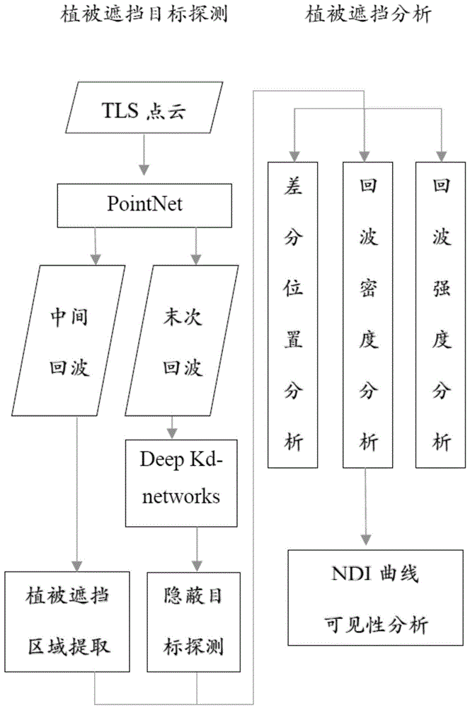
请参考图1所示,本发明包括两块核心内容,分别为植被遮挡目标探测与植被遮挡目标分析。下面结合具体实施例对二者进行论述。Please refer to FIG. 1 , the present invention includes two core contents, which are vegetation occlusion target detection and vegetation occlusion target analysis. The two are discussed below with reference to specific embodiments.
实施例1Example 1
一种用于TLS多回波点云植被遮挡目标的探测方法主要包括以下步骤:A detection method for TLS multi-echo point cloud vegetation occluded targets mainly includes the following steps:
S1、对TLS多回波点云进行点云预处理。S1. Perform point cloud preprocessing on the TLS multi-echo point cloud.
根据全波形TLS获取的多回波点云,为了消除冗余信息,用向上生长法进行地面滤除,然后用基于体素的向上交错分析法进行植被提取。原始点云如图2(a)所示,滤除冗余地面以及植被提取结果如图2(b)所示。According to the multi-echo point cloud acquired by full-waveform TLS, in order to eliminate redundant information, the ground filtering is performed by the up-growing method, and then the vegetation extraction is performed by the voxel-based up-interlacing analysis method. The original point cloud is shown in Figure 2(a), and the redundant ground and vegetation extraction results are shown in Figure 2(b).
S2、将预处理后的点云处理成数据集输入神经网络,进行神经网络的训练。S2. Process the preprocessed point cloud into a data set and input it into a neural network to train the neural network.
将点云分别投影到xy、yz及xz平面,结合点云的强度信息,构成点云的不同三维属性(x,y,I)、(y,z,I)和(x,z,I)并进行训练,其后输入神经网络进行训练。经实验论证,(x,y,I)的训练效果最好,损失率和精确率结果如图3所示,因此,本实施例采用(x,y,I)数据集进行训练。Project the point cloud to the xy, yz and xz planes respectively, and combine the intensity information of the point cloud to form different three-dimensional attributes of the point cloud (x, y, I), (y, z, I) and (x, z, I) And train it, and then input it into the neural network for training. It is proved by experiments that the training effect of (x, y, I) is the best, and the results of loss rate and accuracy rate are shown in Figure 3. Therefore, this embodiment uses the (x, y, I) data set for training.
S3、利用训练好的神经网络识别中间回波,根据识别的中间回波,找出植被遮挡冠层,以此确定植被遮挡区域。S3. Use the trained neural network to identify the intermediate echoes, and find out the vegetation occlusion canopy according to the identified intermediate echoes, so as to determine the vegetation occlusion area.
网络训练完成以后,就可以对TLS多回波中的单次回波、一次回波、中间回波和最后回波进行识别了。由于本发明需要提取植被遮挡区域(即植被遮挡冠层),因此主要针对中间回波进行识别,中间回波识别结果合实际中间回波进行对比,发现精确率达到90%以上。After the network training is completed, the single echo, the first echo, the intermediate echo and the last echo in the TLS multi-echo can be identified. Since the present invention needs to extract the vegetation occluded area (that is, the vegetation occluded canopy), the identification is mainly performed on the intermediate echoes, and the identification results of the intermediate echoes are compared with the actual intermediate echoes, and it is found that the accuracy rate reaches more than 90%.
其后,利用Deep Kd-networks[10]的生成比拟树木遮挡区域TLS多回波点云的生成。将单次回波、一次回波、中间回波和末次回波分别标记为网络的第一层(叶节点)、第二层、第三层和最四层。训练类似于KD树的神经网络,让其学习植被遮挡区域末次回波的形成过程,以区别非植被遮挡区域的末次回波,从而滤除非植被遮挡目标(即显性目标),探测末次回波里面的植被遮挡目标(即隐蔽目标)。植被遮挡区域与植被遮挡目标的探测结果如图4所示,其中,深色部分为植被遮挡目标。如此,即可完成植被遮挡目标的探测。Afterwards, the generation of TLS multi-echo point clouds in tree-occluded regions is compared with the generation of Deep Kd-networks [10]. The single echo, the first echo, the intermediate echo and the last echo are marked as the first layer (leaf node), the second layer, the third layer and the fourth layer of the network, respectively. Train a neural network similar to a KD tree, and let it learn the formation process of the last echo in the vegetation occluded area to distinguish the last echo in the non-vegetation occluded area, so as to filter the non-vegetation occluded target (ie the dominant target), and detect the last echo Vegetation inside occludes the target (ie, the hidden target). The detection results of the vegetation occluded area and the vegetation occluded target are shown in Figure 4, where the dark part is the vegetation occluded target. In this way, the detection of vegetation occluded targets can be completed.
实施例2Example 2
一种用于TLS多回波点云植被遮挡目标的分析方法在实施例1的基础上进行,其包括后续步骤S5。An analysis method for TLS multi-echo point cloud vegetation occlusion targets is performed on the basis of
S5、对植被遮挡目标,进行可见性分析。S5. Perform visibility analysis on the vegetation occlusion target.
S51、对植被遮挡目标进行差分位置分析。S51 , performing differential position analysis on the vegetation occlusion target.
S511、计算植被遮挡区域和植被遮挡目标相邻点之间的三维坐标差值,获得差分位置矩阵。S511. Calculate the three-dimensional coordinate difference between the vegetation occlusion area and the adjacent points of the vegetation occlusion target, and obtain a differential position matrix.
为了能够探寻激光束在穿透树叶间隙时,所贯穿的树木冠层和隐蔽目标三维坐标的变化并挖掘其位置特性。本发明分别计算树冠遮挡区域和隐蔽目标相邻点之间的三维坐标差值:In order to be able to explore the changes of the three-dimensional coordinates of the tree canopy and hidden targets that the laser beam penetrates when penetrating the gap between leaves, and excavate its position characteristics. The present invention calculates the three-dimensional coordinate difference between the canopy occlusion area and the adjacent points of the hidden target respectively:
dx=xi-xi-1;dx=x i -x i-1 ;
dy=yi-yi-1;dy=y i -y i-1 ;
dz=zi-zi-1;dz=z i -z i-1 ;
式中,其中i为样本中第i个点,xi、yi及zi分别为第i个点的三维坐标,dx、dy及dz分别为三维坐标的的差值,A为差值幅度。随之,本发明利用目标点云的差分位置矩阵特征值大小和特征向量方向的变化,分析遮挡目标对隐蔽目标的影响。where i is the i-th point in the sample, x i , y i and zi are the three-dimensional coordinates of the i-th point, respectively, dx, dy and dz are the differences of the three-dimensional coordinates, and A is the magnitude of the difference . Subsequently, the present invention analyzes the influence of the occluded target on the hidden target by using the variation of the eigenvalue size and eigenvector direction of the differential position matrix of the target point cloud.
S512、将得到的差分位置矩阵求特征值,得到复数矩阵,分别用Quiver,Feather,Compass,Angle函数,得到植被遮挡区域和植被遮挡目标的差分位置矩阵特征值可视化图形。S512. Calculate the eigenvalues of the obtained differential position matrix to obtain a complex number matrix, and use the Quiver, Feather, Compass, and Angle functions respectively to obtain a visual graph of the eigenvalues of the differential position matrix of the vegetation occluded area and the vegetation occluded target.
图5为截取的部分植被遮挡区域的位置差分特性和植被遮挡目标的位置差分特性。横坐标代表点的三维坐标差分个数,纵坐标代表点云的差分幅度A。当植被遮挡区域点与点之间距离变大时(图中间区域),植被遮挡目标的点间距很小,说明捕获的植被遮挡目标的点的密度更大,对于其特性的分析更加具有优势。可以看出植被遮挡区域在位置分布上更加均匀分布,而植被遮挡目标在分布上具有很大的不确定性,主要是受植被郁闭度的影响。将得到的差值矩阵求特征值,得到复数矩阵,分别用Quiver,Feather,Compass,Angle函数,得到植被遮挡区域和植被遮挡目标的特征值特性,如图6和图7。FIG. 5 shows the position difference characteristics of the intercepted partial vegetation occlusion areas and the position difference characteristics of the vegetation occlusion targets. The abscissa represents the number of three-dimensional coordinate differences of points, and the ordinate represents the difference amplitude A of the point cloud. When the distance between the points in the vegetation occlusion area becomes larger (the middle area of the figure), the distance between the points of the vegetation occlusion target is very small, which indicates that the density of the captured vegetation occlusion target points is higher, and the analysis of its characteristics is more advantageous. It can be seen that the vegetation occlusion areas are more evenly distributed in location distribution, while the vegetation occlusion targets have great uncertainty in the distribution, which is mainly affected by the vegetation canopy closure. Calculate the eigenvalue of the obtained difference matrix to obtain a complex matrix, and use the Quiver, Feather, Compass, and Angle functions to obtain the eigenvalue characteristics of the vegetation occlusion area and the vegetation occlusion target, as shown in Figure 6 and Figure 7.
S513、对三维坐标差值做二次幂变换和log函数变换,得到植被遮挡区域和植被遮挡目标的二次幂矩阵特征值和特征向量的可视化图形。S513 , performing quadratic power transformation and log function transformation on the three-dimensional coordinate difference to obtain a visualization graph of quadratic power matrix eigenvalues and eigenvectors of the vegetation occlusion area and the vegetation occlusion target.
为了进一步可视化分析遮挡目标和隐蔽目标差分位置的相对变化。本发明对坐标差值做二次幂变换和log函数变换,得到图8。其中EVAL代表特征值样本,EVEC代表特征向量样本。用颜色标记差分位置特征值的大小和特征向量的变化的方向幅度。In order to further visualize the relative changes in the differential positions of occluded targets and hidden targets. The present invention performs quadratic power transformation and log function transformation on the coordinate difference to obtain FIG. 8 . where EVAL represents the eigenvalue sample and EVEC represents the eigenvector sample. The magnitude of the eigenvalues of the differential position and the magnitude of the change of the eigenvectors are color-coded.
从图8可以看出,当遮挡目标特征值和特征向量变化幅度很大时(图8(a)样本1和样本2)时,对应的隐蔽目标特征值变化幅度很小,特征向量的变化更加连续(图8(b):EVEC样本1和EVEC样本2整体连贯性更强)。这说明当树木冠层的叶簇稀疏的频繁变化有利于隐蔽目标点云的生成,被叶簇遮挡的隐蔽目标信息可能更加完善。当遮挡目标特征向量变化幅度较小时(图8(a)样本3)时,对应的隐蔽目标特征向量方向更加具有不连贯性(图8(b):EVEC样本3中间部分明显缺失)。It can be seen from Figure 8 that when the eigenvalues and eigenvectors of the occluded targets change greatly (
S52、对植被遮挡目标进行回波密度分析。S52. Perform echo density analysis on the vegetation occluded target.
S521、获取植被遮挡区域与植被遮挡目标在x、y、z上的点云密度值,并进行归一化。S521 , acquiring point cloud density values of the vegetation occlusion area and the vegetation occlusion target on x, y, and z, and performing normalization.
实验统计了多个树冠层中植被遮挡区域和植被遮挡目标在x,y,z上的密度特性如图9和10。其中颜色的深浅和线条密集程度反映了密度的大小。线条越密集、颜色越深,代表密度越大。从中可以看出不管在x,y还是z轴,如果植被遮挡区域的密度变大,相应的隐蔽目标会变得稀疏。相反,如果植被遮挡区域变稀疏,那么隐蔽目标的密度会有所增加。In the experiment, the density characteristics of vegetation occlusion areas and vegetation occlusion targets in multiple canopy layers in x, y, and z are calculated as shown in Figures 9 and 10. The depth of color and the density of lines reflect the density. The denser the lines and the darker the color, the greater the density. It can be seen from this that no matter in the x, y or z axis, if the density of the vegetation occlusion area increases, the corresponding hidden targets will become sparse. Conversely, if the vegetation occluded area becomes sparse, the density of hidden objects increases.
S522、为对植被遮挡目标进行可见性分析,本发明为植被遮挡区域引入NDI指数。S522 , in order to analyze the visibility of the vegetation occlusion target, the present invention introduces an NDI index into the vegetation occlusion area.
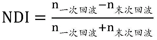
其中,n一次回波代表一次回波的距离范围均值,n末次回波代表末次回波的距离范围均值。Among them, n primary echoes represent the mean value of the distance range of the first echoes, and n last echoes represent the mean value of the distance range of the last echoes.
S523、以归一化的点云密度值为横坐标,以NDI指数为纵坐标,获得NDI指数随点云密度变化的示意图,以此达到可见性分析的需要,其结果如图11所示。S523 , taking the normalized point cloud density as the abscissa and the NDI index as the ordinate, obtain a schematic diagram of the change of the NDI index with the point cloud density, so as to meet the needs of visibility analysis, and the result is shown in FIG. 11 .
由图11中曲线可知,NDI指数随着植被点云密度的增大而减少,特别是当植被冠层点云密度达到一定程度时,NDI指数骤降。因此,本发明中遮挡可见性分析方法适用于高层次少间隙的叶簇穿透模型。由图12选取的三维点云来看,当树叶茂盛时,对于后面的建筑物,该树叶冠层将变得几乎不可穿透。It can be seen from the curve in Figure 11 that the NDI index decreases with the increase of the vegetation point cloud density, especially when the vegetation canopy point cloud density reaches a certain level, the NDI index drops sharply. Therefore, the occlusion visibility analysis method in the present invention is suitable for a high-level leaf cluster penetration model with few gaps. From the 3D point cloud selected in Fig. 12, when the foliage is lush, the foliage canopy will become almost impenetrable to the buildings behind.
S53、对植被遮挡目标进行回波强度分析。S53. Perform echo intensity analysis on the vegetation occluded target.
点云场景中,位于不同位置的点,会因为TLS的相对位置与距离范围、点的质地属性等人为因素和自然因素而后向散射出不同强度值的激光束。激光的能量后向散射传输公式为:In the point cloud scene, points at different positions will backscatter laser beams with different intensity values due to human factors and natural factors such as the relative position and distance range of the TLS, and the texture properties of the points. The energy backscattering transfer formula of laser is:

其中Pt是发射功率,ρ是反射率,R是有效散射半径。这个方程式描述相关功率密度的高低。随着激光束的传播。获得散射体截获的功率密度必须乘以有效散面积As。因为激光波长总是小于散射元素的大小,有效面积只是激光束与目标接触的投影面积。一些能量被散射体接收而被吸收,其余的是向不同方向重新辐射。where P t is the transmit power, ρ is the reflectivity, and R is the effective scattering radius. This equation describes how high or low the relative power density is. with the propagation of the laser beam. Obtaining the power density intercepted by the scatterer must be multiplied by the effective scattering area As . Because the laser wavelength is always smaller than the size of the scattering element, the effective area is simply the projected area of the laser beam in contact with the target. Some of the energy is absorbed by the scatterer and the rest is re-radiated in a different direction.
S531、以点云强度值为横坐标,以点个数为纵坐标,同时,以不同颜色区分不同强度值,获得植被遮挡区域与植被遮挡目标的强度特性图。S531 , taking the point cloud intensity value as the abscissa and the number of points as the ordinate, and at the same time distinguishing different intensity values with different colors, to obtain an intensity characteristic map of the vegetation occlusion area and the vegetation occlusion target.
树冠层中遮挡目标和隐蔽目标的强度特性如图13,其中横坐标代表点云强度值,纵坐标为该强度值下点云个数。颜色变化的深浅也代表强度值变化的趋势,如红黄色代表强度高,绿色代表强度适中,蓝色代表强度很低。从图13中可以看出遮挡目标强度均值明显高于隐蔽目标。遮挡目标点的众数落在[3200,3300]区间,而隐蔽目标点的众数落在[2400,2500]区间。确定强度阈值,可以划分具有不同质地属性的目标。The intensity characteristics of occluded targets and hidden targets in the canopy layer are shown in Figure 13, where the abscissa represents the point cloud intensity value, and the ordinate is the number of point clouds under the intensity value. The depth of the color change also represents the trend of the intensity value change. For example, red and yellow represent high intensity, green represents moderate intensity, and blue represents low intensity. It can be seen from Figure 13 that the mean intensity of occluded targets is significantly higher than that of hidden targets. The mode of the occlusion target points falls in the [3200, 3300] interval, while the mode of the hidden target points falls in the [2400, 2500] interval. Determining the intensity threshold allows to classify objects with different texture properties.
S532、以XY平面植被遮挡区域的差分位置距离为横坐标,以植被遮挡目标的点云强度为纵坐标,获得二者的相关性二维特性图。S532 , taking the differential position distance of the vegetation occlusion area on the XY plane as the abscissa, and taking the point cloud intensity of the vegetation occlusion target as the ordinate, obtain a two-dimensional correlation characteristic map of the two.
S533、分别以植被遮挡区域在X轴与Y轴方向上的差分位置距离dx和dy为X轴与Y轴,以植被遮挡目标的点云强度为纵坐标,建立XY平面上差分位置与点云强度的相关性三维特性图。S533 , using the differential position distances dx and dy of the vegetation occluded area in the X-axis and Y-axis directions as the X-axis and the Y-axis, and the point cloud intensity of the vegetation occlusion target as the ordinate, establish the differential position and point cloud on the XY plane Intensity correlation 3D characteristic map.
由基于PointNet的中间回波植被遮挡区域提取的实验发现,单靠目标的三维坐标区分遮挡区域和非遮挡区域效果并不理想。而且实验发现对于中间回波,其点云坐标x,y和回波强度I相关性较好。为继续探索和验证该结论,本发明选取了一段植被遮挡区域实验样本,如图14。图14(a)描述了遮挡目标XY平面上点云差分位置距离和隐蔽目标点云回波强度的关系。实现发现隐蔽目标回波强度与植被点云差分位置距离成正相关。如图14(b)(c),横坐标和纵坐标分别代表植被等遮挡目标在x轴和y轴方向上的差分位置距离dx和dy,黄色区域代表隐蔽目标点云强度最强的点,蓝色区域代表隐蔽目标点云强度最弱的点。由图14(d)可知,如果植被点云中点与点之间在XY平面上的距离差值越大,那么激光束穿透的几率越高,由此隐蔽目标产生的回波强度也不会因为遮挡效果而发生巨大衰减。而由图像蓝色区域可知,点与点之间间隔很小,即在树丛密集的情况下,树冠层会很大程度地衰减激光束强度,从而大大影响了隐蔽目标的探测。The experiment of extracting the occluded area of intermediate echo vegetation based on PointNet shows that the effect of distinguishing occluded area and non-occluded area only by the 3D coordinates of the target is not ideal. And the experiment found that for the intermediate echo, the point cloud coordinates x, y and the echo intensity I have a good correlation. In order to continue to explore and verify this conclusion, the present invention selects an experimental sample of a vegetation occlusion area, as shown in FIG. 14 . Figure 14(a) depicts the relationship between the point cloud differential position distance on the XY plane of the occlusion target and the echo intensity of the occluded target point cloud. It is realized that the echo intensity of the hidden target is positively correlated with the differential position distance of the vegetation point cloud. As shown in Figure 14(b)(c), the abscissa and ordinate represent the differential position distances dx and dy of vegetation and other occluded targets in the x-axis and y-axis directions respectively, and the yellow area represents the point with the strongest hidden target point cloud intensity, The blue area represents the weakest point in the hidden target point cloud. It can be seen from Figure 14(d) that if the distance difference between the mid-point of the vegetation point cloud and the point on the XY plane is larger, the probability of the laser beam penetrating is higher, and the echo intensity generated by the hidden target is also not high. There will be huge falloff due to occlusion effects. It can be seen from the blue area of the image that the interval between points is very small, that is, in the case of dense trees, the canopy layer will attenuate the intensity of the laser beam to a great extent, thus greatly affecting the detection of hidden targets.
以上所述,仅为本发明较佳的具体实施方式,但本发明的保护范围并不局限于此,任何熟悉本技术领域的技术人员在本发明揭露的技术范围内,可轻易想到的变化或替换,都应涵盖在本发明的保护范围之内。因此,本发明的保护范围应该以权利要求的保护范围为准。The above description is only a preferred embodiment of the present invention, but the protection scope of the present invention is not limited to this. Substitutions should be covered within the protection scope of the present invention. Therefore, the protection scope of the present invention should be subject to the protection scope of the claims.
Claims (6)

Priority Applications (1)
| Application Number | Priority Date | Filing Date | Title |
|---|---|---|---|
| CN201811494004.4A CN109613552B (en) | 2018-12-07 | 2018-12-07 | Detection and analysis method for TLS multi-echo point cloud vegetation shielding target |
Applications Claiming Priority (1)
| Application Number | Priority Date | Filing Date | Title |
|---|---|---|---|
| CN201811494004.4A CN109613552B (en) | 2018-12-07 | 2018-12-07 | Detection and analysis method for TLS multi-echo point cloud vegetation shielding target |
Publications (2)
| Publication Number | Publication Date |
|---|---|
| CN109613552A CN109613552A (en) | 2019-04-12 |
| CN109613552B true CN109613552B (en) | 2020-11-10 |
Family
ID=66008523
Family Applications (1)
| Application Number | Title | Priority Date | Filing Date |
|---|---|---|---|
| CN201811494004.4A Active CN109613552B (en) | 2018-12-07 | 2018-12-07 | Detection and analysis method for TLS multi-echo point cloud vegetation shielding target |
Country Status (1)
| Country | Link |
|---|---|
| CN (1) | CN109613552B (en) |
Families Citing this family (6)
| Publication number | Priority date | Publication date | Assignee | Title |
|---|---|---|---|---|
| CN110399655A (en) * | 2019-07-08 | 2019-11-01 | 自然资源部海洋减灾中心 | A method of vegetation wave absorption is predicted based on machine learning |
| AU2020428327B2 (en) * | 2020-02-14 | 2023-11-16 | Ntt, Inc. | Learning device, learning method, and learning program |
| CN112068153B (en) * | 2020-08-24 | 2022-07-29 | 电子科技大学 | Crown clearance rate estimation method based on foundation laser radar point cloud |
| CN114779202B (en) * | 2022-06-17 | 2022-10-04 | 之江实验室 | Method, device and system for detecting, identifying and positioning forest shielding target |
| JP7653549B1 (en) | 2024-01-22 | 2025-03-28 | 株式会社京三製作所 | DETECTION APPARATUS AND DETECTION METHOD |
| CN119919673A (en) * | 2025-04-02 | 2025-05-02 | 湖北迈睿达供应链股份有限公司 | A method for determining obscured targets based on mapping laser |
Citations (5)
| Publication number | Priority date | Publication date | Assignee | Title |
|---|---|---|---|---|
| CN103035006A (en) * | 2012-12-14 | 2013-04-10 | 南京大学 | High-resolution aerial image partition method based on LEGION and under assisting of LiDAR |
| CN104318611A (en) * | 2014-10-27 | 2015-01-28 | 祁海江 | Three-dimensional tree re-establishing method based on laser scanning point cloud |
| CN105701856A (en) * | 2016-01-15 | 2016-06-22 | 厦门大学 | Vegetation extraction method and system |
| CN106599808A (en) * | 2016-12-01 | 2017-04-26 | 中国科学院光电研究院 | Full-waveform laser radar data based concealed target extraction method |
| CN106651863A (en) * | 2016-11-30 | 2017-05-10 | 厦门大学 | Point cloud data based automatic tree cutting method |
Family Cites Families (5)
| Publication number | Priority date | Publication date | Assignee | Title |
|---|---|---|---|---|
| US9063544B2 (en) * | 2012-09-19 | 2015-06-23 | The Boeing Company | Aerial forest inventory system |
| CN105469098B (en) * | 2015-11-20 | 2018-10-12 | 中北大学 | A kind of LIDAR data atural object precise classification methods of self-adaptive features priority aggregation |
| CN105551082B (en) * | 2015-12-02 | 2018-09-07 | 百度在线网络技术(北京)有限公司 | A kind of pavement identification method and device based on laser point cloud |
| CN106408011B (en) * | 2016-09-09 | 2020-04-17 | 厦门大学 | Laser scanning three-dimensional point cloud tree automatic classification method based on deep learning |
| CN107944383A (en) * | 2017-11-21 | 2018-04-20 | 航天科工智慧产业发展有限公司 | Building roof patch division method based on three-dimensional Voronoi diagram |
-
2018
- 2018-12-07 CN CN201811494004.4A patent/CN109613552B/en active Active
Patent Citations (5)
| Publication number | Priority date | Publication date | Assignee | Title |
|---|---|---|---|---|
| CN103035006A (en) * | 2012-12-14 | 2013-04-10 | 南京大学 | High-resolution aerial image partition method based on LEGION and under assisting of LiDAR |
| CN104318611A (en) * | 2014-10-27 | 2015-01-28 | 祁海江 | Three-dimensional tree re-establishing method based on laser scanning point cloud |
| CN105701856A (en) * | 2016-01-15 | 2016-06-22 | 厦门大学 | Vegetation extraction method and system |
| CN106651863A (en) * | 2016-11-30 | 2017-05-10 | 厦门大学 | Point cloud data based automatic tree cutting method |
| CN106599808A (en) * | 2016-12-01 | 2017-04-26 | 中国科学院光电研究院 | Full-waveform laser radar data based concealed target extraction method |
Also Published As
| Publication number | Publication date |
|---|---|
| CN109613552A (en) | 2019-04-12 |
Similar Documents
| Publication | Publication Date | Title |
|---|---|---|
| CN109613552B (en) | Detection and analysis method for TLS multi-echo point cloud vegetation shielding target | |
| JP5891560B2 (en) | Identification-only optronic system and method for forming three-dimensional images | |
| CN106066154B (en) | A kind of extracting method of target and its control point suitable for quickly scanning scene | |
| CN104155638B (en) | A kind of seeds sorting technique based on the pseudo-vertical waveform model of LiDAR | |
| JP2008292449A (en) | Automatic target identifying system for detecting and classifying object in water | |
| Liu et al. | Classification of airborne lidar intensity data using statistical analysis and hough transform with application to power line corridors | |
| JP6207144B2 (en) | Method for 3D reconstruction of objects in a scene | |
| CN104820830A (en) | Tree species identification method based on full-waveform LiDAR canopy profile model | |
| CN109061658B (en) | Laser radar data fusion method | |
| CN112859027B (en) | A decoy array interference effectiveness analysis method based on one-dimensional range image | |
| CN115964837B (en) | A Simulation Method for Laser Scanning Point Clouds of Complex Underwater Targets Based on Ray Tracing | |
| Del Rio Vera et al. | Automatic target recognition in synthetic aperture sonar images based on geometrical feature extraction | |
| Pesci et al. | Remote sensing of volcanic terrains by terrestrial laser scanner: preliminary reflectance and RGB implications for studying Vesuvius crater (Italy) | |
| CN119168890B (en) | Point cloud generation method and device based on millimeter wave and visual image fusion | |
| CN120103310A (en) | A laser radar ranging process simulation method suitable for complex scenes | |
| Li et al. | A novel full-waveform LiDAR echo decomposition method and simulation verification | |
| Moik et al. | Measurement of sawlog stacks on an individual log basis using LiDAR | |
| KR101696088B1 (en) | Method for recognizing object by ultrasound and apparatus therefor | |
| Groenwall et al. | Methods for recognition of natural and man-made objects using laser radar data | |
| Czúni et al. | Color based clustering for trunk segmentation | |
| Grönwall | Ground Object Recognition using Laser Radar Data Geometric Fitting, Performance Analysis, and Applications | |
| CN120762046B (en) | High-precision geospatial information acquisition mapping method and system | |
| Guo et al. | A pregeneration–recognition method of detecting weak seafloor echoes for full-waveform airborne LiDAR bathymetry | |
| Lindberg | Estimation of canopy structure and individual trees from laser scanning data | |
| CN120742273B (en) | A method, system, terminal, and storage medium for high-density noise processing of surface point clouds in blue-green lidar. |
Legal Events
| Date | Code | Title | Description |
|---|---|---|---|
| PB01 | Publication | ||
| PB01 | Publication | ||
| SE01 | Entry into force of request for substantive examination | ||
| SE01 | Entry into force of request for substantive examination | ||
| GR01 | Patent grant | ||
| GR01 | Patent grant |