CN101799552B - Method for positioning dual-system combined satellite navigation receiver - Google Patents
Method for positioning dual-system combined satellite navigation receiver Download PDFInfo
- Publication number
- CN101799552B CN101799552B CN2010101230178A CN201010123017A CN101799552B CN 101799552 B CN101799552 B CN 101799552B CN 2010101230178 A CN2010101230178 A CN 2010101230178A CN 201010123017 A CN201010123017 A CN 201010123017A CN 101799552 B CN101799552 B CN 101799552B
- Authority
- CN
- China
- Prior art keywords
- satellite
- receiver
- centerdot
- pseudo
- rho
- Prior art date
- Legal status (The legal status is an assumption and is not a legal conclusion. Google has not performed a legal analysis and makes no representation as to the accuracy of the status listed.)
- Expired - Fee Related
Links
Images


Landscapes
- Position Fixing By Use Of Radio Waves (AREA)
Abstract
本发明公开了一种双系统组合卫星导航接收机定位方法。首先获取卫星位置及伪距观测量;然后根据观测卫星的不同情况,采用不同的步骤来完成接收机定位处理,获取接收机位置;最后输出定位结果。该方法根据可见卫星个数有两种解决方案,其一,是当两个卫星系统均有三颗可见卫星的情况,利用一元二次方程的代数处理方法可以最终获得接收机的位置;其二,是当两个卫星系统可见七颗及七颗以上卫星的情况,利用观测信息的冗余性将观测方程组转化为一次方程组,最终利用最小二乘方法直接进行处理。该方法不需要导航位置初始估计值,也不需要迭代运算处理,可使接收机在深空探测及其它特殊环境中得到可靠的定位结果。
The invention discloses a positioning method for a dual-system combined satellite navigation receiver. Firstly, the satellite position and pseudo-range observations are obtained; then according to the different situations of the observed satellites, different steps are used to complete the receiver positioning process, and the receiver position is obtained; finally, the positioning results are output. This method has two solutions according to the number of visible satellites. One is that when two satellite systems have three visible satellites, the position of the receiver can be finally obtained by using the algebraic processing method of quadratic equation in one element; the other is that When two satellite systems can see seven or more satellites, the redundancy of observation information is used to transform the observation equations into a linear equation, and finally the least square method is used to directly process them. This method does not require the initial estimated value of the navigation position, nor does it need iterative calculation processing, so that the receiver can obtain reliable positioning results in deep space exploration and other special environments.
Description
技术领域 technical field
本发明属于卫星导航通信领域,具体涉及一种双系统组合卫星导航接收机定位方法。The invention belongs to the field of satellite navigation communication, and in particular relates to a dual-system combined satellite navigation receiver positioning method.
背景技术 Background technique
全球卫星导航定位系统已经成为全球发展最快的信息产业之一,可以给用户提供定位、测速和授时等服务,并具有全球性、全天候、连续性和实时性的特点。目前已有的两大卫星定位系统是美国的全球定位系统(Global Position System,简称为GPS)和俄罗斯的GLONASS系统(GLObal Navigation Satellite System,简称为GLONASS),处于设计建造阶段的主要有欧洲的伽利略系统和中国的BD2系统(Compass system,通常称为BD2)。双系统组合或多系统组合卫星导航接收机将比单系统卫星接收机具有更高的可靠性、可用性。因此,双系统组合或多系统组合卫星导航接收机成为目前研究的热点。The global satellite navigation and positioning system has become one of the fastest-growing information industries in the world. It can provide users with positioning, speed measurement and timing services, and has the characteristics of global, all-weather, continuity and real-time. At present, the two existing satellite positioning systems are the Global Positioning System (Global Position System, referred to as GPS) of the United States and the GLONASS system (GLObal Navigation Satellite System, referred to as GLONASS) of Russia. Galileo in Europe is mainly in the design and construction stage. system and China's BD2 system (Compass system, commonly referred to as BD2). Dual-system combination or multi-system combination satellite navigation receivers will have higher reliability and availability than single-system satellite receivers. Therefore, dual-system combination or multi-system combination satellite navigation receiver has become a hot research topic at present.
单系统卫星导航定位时,伪距观测方程中,含有3个接收机位置未知数和1个接收机相对于卫星系统钟差未知数,因此,单系统卫星导航定位处理至少需要4个观测量,至少需要4颗可见卫星;双系统组合卫星导航定位时,伪距观测方程中,含有3个接收机位置未知数和接收机相对于2个卫星系统的钟差未知数,因此,双系统卫星导航定位处理至少需要5个观测量,至少需要5颗可见卫星;依次类推,多系统组合时,需要更多的可见卫星提供观测信息进行定位处理。During single-system satellite navigation and positioning, the pseudo-range observation equation contains 3 receiver position unknowns and 1 receiver relative to the satellite system clock error unknown. Therefore, single-system satellite navigation and positioning processing requires at least 4 observations, and at least 4 visible satellites; when dual-system combined satellite navigation and positioning, the pseudo-range observation equation contains 3 receiver position unknowns and the receiver’s clock difference unknowns relative to the 2 satellite systems, therefore, dual-system satellite navigation and positioning processing requires at least For 5 observations, at least 5 visible satellites are required; by analogy, when multiple systems are combined, more visible satellites are required to provide observation information for positioning processing.
在获得伪距观测量后,通常的方法是将观测方程线性化,而后采用最小二乘法或卡尔曼滤波方法进行导航定位处理。由于在一些特殊环境中,如深空探测、仰角约束较为苛刻的山区等,卫星导航接收机的可见卫星位置分布比较差,可能会导致最小二乘法及卡尔曼滤波方法发散、不收敛,因此,Bancroft等人提出了一类可以不经过线性化而直接对卫星观测的非线性方程组进行处理的方法,利用此类方法可以避免迭代发散问题,保证定位结果的稳定可靠。After obtaining the pseudo-range observation, the usual method is to linearize the observation equation, and then use the least square method or Kalman filter method for navigation and positioning processing. Because in some special environments, such as deep space exploration and mountainous areas with strict elevation angle constraints, the distribution of visible satellite positions of satellite navigation receivers is relatively poor, which may cause the least squares method and the Kalman filter method to diverge and not converge. Therefore, Bancroft et al. proposed a method that can directly process the nonlinear equations of satellite observation without linearization. Using this method can avoid the iterative divergence problem and ensure the stability and reliability of the positioning results.
目前,针对单系统直接定位处理的主要方法有:At present, the main methods for direct positioning processing of a single system are:
美国的Bancroft于1985年提出的Bancroft方法:这是一种不需要迭代的全局性非线性最小二乘方法,主要依据是四维空间下的洛伦兹(Lorentz)内积;The Bancroft method proposed by Bancroft in the United States in 1985: This is a global nonlinear least squares method that does not require iteration, mainly based on the Lorentz (Lorentz) inner product in the four-dimensional space;
Krause于1987年提出的Krause方法:这是一种针对GPS类型导航方程的代数化解析处理的方法,Krause方法利用可见卫星构造测量平面,并选择其中一个作为参考测量平面,根据参考测量平面,构造一个垂直于该平面的辅助向量,推导了卫星到接收机向量与辅助向量及接收机钟差的线性关系;The Krause method proposed by Krause in 1987: This is a method for algebraic analytical processing of GPS-type navigation equations. The Krause method uses visible satellites to construct a measurement plane, and selects one of them as a reference measurement plane. According to the reference measurement plane, construct An auxiliary vector perpendicular to the plane, deriving the linear relationship between the satellite-to-receiver vector and the auxiliary vector and receiver clock error;
Abel.J.S于1991年提出的Abel方法:这是一种直接处理GPS导航方程的代数方法,Abel方法选择一颗卫星作为参考卫星,并将其作为新坐标系的坐标原点,在此定义下,重新改写观测方程,并经过推导最终得到关于接收机位置的一个一元二次方程,直接求解一元二次方程获得两个可能解,然后根据条件进行错误解的排除,最终获得正确的定位结果。The Abel method proposed by Abel.J.S in 1991: This is an algebraic method that directly deals with GPS navigation equations. The Abel method selects a satellite as a reference satellite and uses it as the coordinate origin of the new coordinate system. Under this definition, Rewrite the observation equation, and finally obtain a quadratic equation about the receiver position after derivation, directly solve the quadratic equation to obtain two possible solutions, and then eliminate the wrong solution according to the conditions, and finally obtain the correct positioning result.
上述这些方法都是针对单系统定位应用的,对于双系统组合定位处理,由于多了一个钟差未知数,导致双系统卫星导航接收机的观测方程组不同于单系统的观测方程组,这使得这些方法不再适用于双系统卫星导航接收机。The above methods are all aimed at the application of single-system positioning. For the dual-system combined positioning processing, due to the addition of an unknown clock error, the observation equations of the dual-system satellite navigation receiver are different from the observation equations of the single system, which makes these The method no longer applies to dual system satellite navigation receivers.
常规的观测方程线性化处理方法为:The conventional linearization processing method of the observation equation is:
双系统组合定位接收机同时观测到N颗卫星时,可以得到如下观测方程组:When the dual-system combined positioning receiver observes N satellites at the same time, the following observation equations can be obtained:
式中,ρi(t)表示伪距测量值,Di(t)为卫星到接收机的真实距离,c为光速,δtk(t)为接收机时钟相对两个系统的钟差,下标i表示观测卫星的标号,下标k表示两个不同的卫星导航定位系统,由于每个卫星导航定位系统都采用单独定义并维持的时间系统,且这些时间系统之间存在不固定的偏差,因此,双系统定位解算时,将会有两个接收机钟差,分别表示对两个单独的时间系统的偏差。In the formula, ρ i (t) represents the pseudo-range measurement value, D i (t) is the true distance from the satellite to the receiver, c is the speed of light, δt k (t) is the clock difference of the receiver clock relative to the two systems, the following The subscript i indicates the number of the observation satellite, and the subscript k indicates two different satellite navigation and positioning systems. Since each satellite navigation and positioning system adopts a separately defined and maintained time system, and there is an unfixed deviation between these time systems, Therefore, when the dual-system positioning is solved, there will be two receiver clock differences, which represent the deviations from two separate time systems.
式中,Xi为卫星坐标列向量,Xi=[xi yi zi]T,xi、yi、zi表示卫星的三维坐标,Xu为接收机坐标列向量,Xu=[xu yu zu]T,xu、yu、zu表示接收机的三维坐标。In the formula, Xi i is the satellite coordinate column vector, Xi i =[xi y i z i ] T , x i , y i , zi represent the three-dimensional coordinates of the satellite, Xu is the receiver coordinate column vector, Xu = [x u y u z u ] T , x u , y u , zu represent the three-dimensional coordinates of the receiver.
将Di(t)在接收机初始位置估计值(x0,y0,z0)处用泰勒级数展开,并且只取其一次近似,这样可以将非线性方程改写为线性化的形式:Expand D i (t) at the estimated value of the initial position of the receiver (x 0 , y 0 , z 0 ) with Taylor series, and only take its first approximation, so that the nonlinear equation can be rewritten into a linearized form:
Di(t)=[-li(t),-mi(t),-ni(t)][δx,δy,δz]T+Di0(t) (3)D i (t) = [-l i (t), -m i (t), -n i (t)] [δx, δy, δz] T + D i0 (t) (3)
式中,
对观测方程组进行整理可得如下矩阵形式:The following matrix form can be obtained by sorting the observation equations:
H(t)δT+L(t)=0 (4)H(t)δT+L(t)=0
假设卫星1~卫星j属于第一系统,卫星j+1~卫星N属于第二系统,(4)式中的矩阵分别为:Assuming that
其中,H(t)矩阵表示方向余弦矩阵,δT表示待求矩阵,L(t)表示伪距观测量与初始距离估计值的差。Among them, the H(t) matrix represents the direction cosine matrix, δT represents the matrix to be obtained, and L(t) represents the difference between the pseudorange observation and the initial distance estimate.
利用最小二乘法可以求得δT:δT can be obtained by the method of least squares:
δT=-(H(t)TH(t))-1(H(t)TL(t)) (5)δT=-(H(t) T H(t)) -1 (H(t) T L(t)) (5)
上述常规的观测方程线性化的方法在通常情况下都可以得到很好的定位结果,但是在一些特殊应用环境中,如深空探测等,有可能会使定位结果不收敛,不能保证可靠地定位。The above conventional method of linearizing the observation equation can obtain good positioning results under normal circumstances, but in some special application environments, such as deep space exploration, the positioning results may not converge, and reliable positioning cannot be guaranteed .
发明内容 Contents of the invention
本发明的目的:提供双系统组合卫星导航接收机定位方法,使得双系统接收机在深空探测等特殊使用环境中仍然可以得到可靠有效的定位结果。The purpose of the present invention is to provide a positioning method for a dual-system integrated satellite navigation receiver, so that the dual-system receiver can still obtain reliable and effective positioning results in special environments such as deep space exploration.
本发明的双系统组合卫星导航接收机定位方法包括如下步骤:The dual-system combined satellite navigation receiver positioning method of the present invention comprises the following steps:
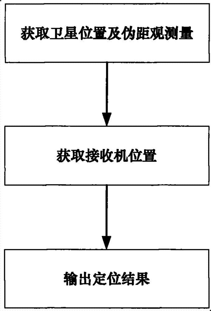
步骤1:获取卫星位置及伪距观测量;Step 1: Obtain satellite position and pseudo-range observations;
在接收机跟踪到卫星信号后,根据获得的导航电文,得到卫星的位置;同时由接收机基带模块得到卫星的伪距测量值;After the receiver tracks the satellite signal, the position of the satellite is obtained according to the obtained navigation message; at the same time, the pseudo-range measurement value of the satellite is obtained by the baseband module of the receiver;
步骤2:获取接收机位置;Step 2: Obtain the location of the receiver;
根据观测卫星的两种不同情况,采用不同的步骤来完成接收机定位处理:According to two different situations of observing satellites, different steps are used to complete the receiver positioning processing:
第一种情况:两个卫星导航系统分别有三颗可见卫星的情况;The first case: two satellite navigation systems have three visible satellites respectively;
第二种情况:两个卫星导航系统一共有七颗或七颗以上可见卫星的情况。The second case: the two satellite navigation systems have a total of seven or more visible satellites.
下面针对两种不同情况,分别介绍定位处理的方法步骤:In the following two different situations, the method steps of positioning processing are respectively introduced:
1、两个卫星导航系统分别有三颗可见卫星的情况1. Two satellite navigation systems have three visible satellites respectively
此种情况下,定位处理的步骤如下:In this case, the steps of positioning processing are as follows:
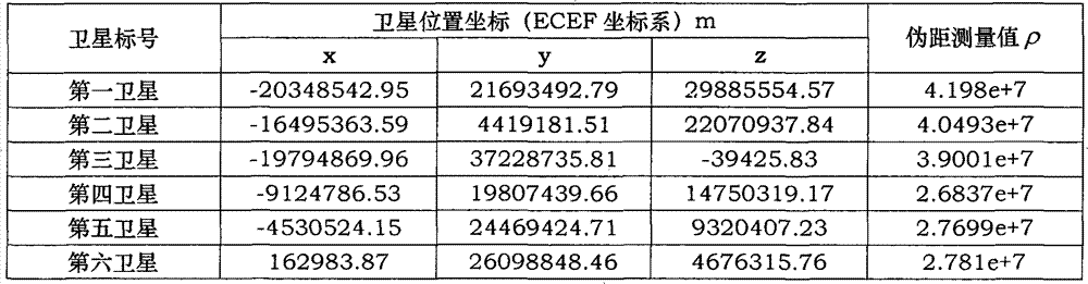
步骤2.1.1:整理六颗观测卫星的位置及伪距测量值;Step 2.1.1: sort out the positions and pseudorange measurements of the six observation satellites;
不失一般性,设第一卫星、第二卫星和第三卫星属于第一系统,第四卫星、第五卫星和第六卫星属于第二系统;选择第一卫星作为第一系统的参考卫星、选择第四卫星作为第二系统的参考卫星,根据步骤1已经得到这六颗可见卫星的位置Xi、伪距测量值ρi。Xi为卫星坐标列向量,Xi=[xi yi zi]T,ρi=Di+c*δtk,其中Di为第i卫星到接收机的真实距离,c为光速,δtk为接收机时钟相对第一系统和第二系统的钟差,其中i=1,2,3,…,6;当i=1,2,3时,k=1;当i=4,5,6时,k=2;Without loss of generality, suppose the first satellite, the second satellite and the third satellite belong to the first system, and the fourth satellite, the fifth satellite and the sixth satellite belong to the second system; choose the first satellite as the reference satellite of the first system, The fourth satellite is selected as the reference satellite of the second system, and the positions Xi and pseudorange measurement values ρ i of the six visible satellites have been obtained according to
步骤2.1.2:获取非参考卫星与参考卫星的伪距测量值之差;Step 2.1.2: Obtain the difference between the pseudorange measurement values of the non-reference satellite and the reference satellite;
利用第二卫星、第三卫星的伪距测量值与第一卫星的伪距测量值做差,利用第五卫星、第六卫星的伪距测量值与第四卫星的伪距测量值做差,得到非参考卫星与参考卫星的伪距测量值之差di,i=2,3,5,6;Using the second satellite, the third satellite's pseudo-range measurement value and the first satellite's pseudo-range measurement value to make a difference, utilizing the fifth satellite, the sixth satellite's pseudo-range measurement value and the fourth satellite's pseudo-range measurement value to make a difference, Obtain the difference d i between the pseudorange measurement values of the non-reference satellite and the reference satellite, i=2, 3, 5, 6;
步骤2.1.3:构造接收机位置与参考卫星真实距离之间的线性关系;Step 2.1.3: Construct the linear relationship between the receiver position and the true distance of the reference satellite;
利用步骤1中得到的卫星位置、步骤2.1.2中得到的伪距测量值之差,构造接收机位置与第一系统参考卫星到接收机的真实距离D1和第二系统参考卫星到接收机的真实距离D4的线性关系方程;Using the difference between the satellite position obtained in
步骤2.1.4:构造第一系统参考卫星到接收机的真实距离D1和第二系统参考卫星到接收机的真实距离D4的代数关系;Step 2.1.4: Construct the algebraic relationship between the real distance D 1 from the first system reference satellite to the receiver and the real distance D 4 from the second system reference satellite to the receiver;
将第一系统参考卫星到接收机的真实距离D1和第二系统参考卫星到接收机的真实距离D4作为未知数,利用已有观测信息构造关于D1和D4的方程;Taking the real distance D 1 from the first system reference satellite to the receiver and the real distance D 4 from the second system reference satellite to the receiver as unknowns, using existing observation information to construct equations about D 1 and D 4 ;
步骤2.1.5获取接收机到参考卫星的真实距离,并进行结果的取舍;Step 2.1.5 Obtain the real distance from the receiver to the reference satellite, and make a choice of the result;
将步骤2.1.4中得到的D1和D4的一次关系式代入二次关系式中,得到关于D4的一元二次方程,利用此一元二次方程可以获得D4的两个结果,继而由D1和D4的一次关系式得到D1的两个结果,从而得到两组解,根据如下原则进行解的取舍:Substituting the primary relational expression of D1 and D4 obtained in step 2.1.4 into the quadratic relational expression to obtain a quadratic equation of one element about D4 , two results of D4 can be obtained by using this quadratic equation of one element, and then The two results of D 1 are obtained from the first-order relationship of D 1 and D 4 , so as to obtain two sets of solutions, and the solutions are selected according to the following principles:
(a)根据D1和D4的物理意义,应满足条件:D1>0,D4>0;(a) According to the physical meaning of D 1 and D 4 , the conditions should be met: D 1 >0, D 4 >0;
(b)根据矢量关系式:|‖x‖-‖y‖|≤‖x-y‖,D1=‖X1-Xu‖,D4=‖X4-Xu‖,因此D1和D4还应满足条件:|D1-D4|≤‖X1-X4‖(b) According to the vector relation: |‖x‖-‖y‖|≤‖xy‖, D 1 =‖X 1 -X u ‖, D 4 =‖X 4 -X u ‖, so D 1 and D 4 The condition should also be met: |D 1 -D 4 |≤‖X 1 -X 4 ‖
(c)δt1=tR-Tsat1,δt2=tR-Tsat2,其中,tR是接收机时钟,Tsat1是第一系统的系统时间,Tsat2是第二系统的系统时间,因此,δt1-δt2=Tsat2-Tsat1。(c) δt 1 =t R -T sat1 , δt 2 =t R -T sat2 , where t R is the receiver clock, T sat1 is the system time of the first system, and T sat2 is the system time of the second system, Therefore, δt 1 -δt 2 =T sat2 -T sat1 .
根据:ρ1=D1+c*δt1,ρ4=D4+c*δt2可以得到:|c*δt2-c*δt1|=|ρ4-D4-ρ1+D1|。由于第一系统和第二系统的时间偏差范围是已知的,且通常不会很大,设其最大值为dtmax,则|ρ4-D4-ρ1+D1|≤c*dtmax According to: ρ 1 =D 1 +c*δt 1 , ρ 4 =D 4 +c*δt 2 can get: |c*δt 2 -c*δt 1 |=|ρ 4 -D 4 -ρ 1 +D 1 |. Since the time deviation range between the first system and the second system is known and usually not very large, let its maximum value be dt max , then |ρ 4 -D 4 -ρ 1 +D 1 |≤c*dt max
经过上面三个条件的排除,将得到一组唯一的D1和D4;After the exclusion of the above three conditions, a unique set of D 1 and D 4 will be obtained;
步骤2.1.6:获得接收机位置向量和接收机相对两个系统的钟差;Step 2.1.6: Obtain the receiver position vector and the clock difference of the receiver relative to the two systems;
将步骤2.1.5中得到的D1和D4的值代入到步骤2.1.3中得到的接收机位置Xu与D1和D4的线性关系方程中,获得接收机位置Xu,同时利用ρ1=D1+c*δt1,ρ4=D4+c*δt2得到接收机相对两个系统的钟差δt1和δt2。Substitute the values of D 1 and D 4 obtained in step 2.1.5 into the linear relationship equation between receiver position X u and D 1 and D 4 obtained in step 2.1.3 to obtain receiver position X u , and use ρ 1 =D 1 +c*δt 1 , ρ 4 =D 4 +c*δt 2 to obtain clock differences δt 1 and δt 2 of the receiver relative to the two systems.
2、两个卫星导航系统一共有七颗或七颗以上可见卫星的情况2. There are seven or more visible satellites in two satellite navigation systems
此种情况下,定位方法的步骤如下:In this case, the steps of the positioning method are as follows:
步骤2.2.1:整理同时观测到的七颗或七颗以上卫星的位置及伪距测量值;Step 2.2.1: sort out the positions and pseudorange measurements of seven or more satellites observed at the same time;
不失一般性,假设某时刻同时观测到N颗卫星,其中N1颗卫星属于第一系统,剩余N2颗卫星属于第二系统。N、N1和N2满足条件:N、N1和N2均为正整数,且N≥7,1≤N1<N,N2=N-N1;Without loss of generality, assume that N satellites are observed at the same time at a certain moment, of which N 1 satellites belong to the first system, and the remaining N 2 satellites belong to the second system. N, N 1 and N 2 satisfy the conditions: N, N 1 and N 2 are all positive integers, and N≥7, 1≤N 1 <N, N 2 =NN 1 ;
步骤2.2.2:将未知数及其平方项作为新的未知数,构造新的线性矩阵方程;Step 2.2.2: Construct a new linear matrix equation with the unknown and its square term as the new unknown;
整理观测方程,通过取平方去掉开方项,并将方程中的未知数xu,yu,zu,b1,b2及其平方项xu 2,yu 2,zu 2,b1 2,b2 2作为新的待求未知数,并令:f1=xu,f2=yu,f3=zu,f4=b1,f5=b2,
步骤2.2.3:根据新的线性矩阵方程,得到接收机位置和接收机相对两个系统的钟差;Step 2.2.3: According to the new linear matrix equation, the position of the receiver and the clock difference of the receiver relative to the two systems are obtained;
利用最小二乘法处理步骤2.2.2所得到的新的线性矩阵方程,从而得到接收机位置Xu=[xu yu zu]T、接收机相对第一系统的钟差δt1以及接收机相对第二系统的钟差δt2。Process the new linear matrix equation obtained in step 2.2.2 by the least square method, so as to obtain the receiver position X u =[x u y u z u ] T , the clock error δt 1 of the receiver relative to the first system and the receiver Relative to the clock error δt 2 of the second system.
步骤3:输出定位结果。Step 3: Output the positioning result.
将得到的接收机位置Xu=[xu yu zu]T、接收机相对第一系统的钟差δt1以及接收机相对第二系统的钟差δt2通过通讯接口输出给用户。The obtained receiver position X u =[x u y u z u ] T , the clock error δt 1 of the receiver relative to the first system, and the clock error δt 2 of the receiver relative to the second system are output to the user through the communication interface.
本发明具有如下优点:The present invention has the following advantages:
(1)在可见卫星满足条件时,利用本发明提供的定位方法能够保证在特殊使用环境中仍然能提供有效可靠的定位结果;(1) When the visible satellite meets the conditions, using the positioning method provided by the present invention can ensure that an effective and reliable positioning result can still be provided in a special use environment;
(2)本发明所提出的定位方法不需要对接收机的位置进行估计;(2) The positioning method proposed by the present invention does not need to estimate the position of the receiver;
(3)本发明所提出的定位方法处理过程不需要迭代运算,不存在发散问题,保证了导航定位的可靠性。(3) The processing process of the positioning method proposed by the present invention does not require iterative calculations, and there is no divergence problem, which ensures the reliability of navigation and positioning.
附图说明 Description of drawings
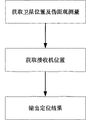
图1是本发明双系统组合卫星导航接收机定位方法流程图;Fig. 1 is the flow chart of positioning method of dual system combined satellite navigation receiver of the present invention;
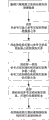
图2是本发明两个卫星导航系统分别有三颗可见卫星时的处理流程图;Fig. 2 is the processing flowchart when two satellite navigation systems of the present invention have three visible satellites respectively;
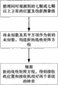
图3是本发明两个卫星导航系统一共有七颗或七颗以上可见卫星时的处理流程图;Fig. 3 is the processing flowchart when two satellite navigation systems of the present invention have altogether seven or more visible satellites;
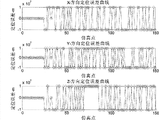
图4是现有线性化方法在两个卫星导航系统分别有三颗可见卫星时的定位误差结果;Fig. 4 is the positioning error result of the existing linearization method when two satellite navigation systems respectively have three visible satellites;
图5是本发明方法在两个卫星导航系统分别有三颗可见卫星时的定位误差结果;Fig. 5 is the positioning error result when the inventive method has three visible satellites respectively in two satellite navigation systems;
图6是现有线性化方法在两个卫星导航系统一共有七颗可见卫星时的定位误差结果;Fig. 6 is the positioning error result of the existing linearization method when there are seven visible satellites in the two satellite navigation systems;
图7是本发明方法在两个卫星导航系统一共有七颗可见卫星时的定位误差结果。Fig. 7 is the positioning error result of the method of the present invention when two satellite navigation systems have a total of seven visible satellites.
具体实施方式 Detailed ways
下面结合附图对本发明的具体实施方式进行说明。Specific embodiments of the present invention will be described below in conjunction with the accompanying drawings.
本发明所述的是一种双系统组合卫星导航接收机定位方法,如图1所示,该方法包括如下步骤:Described in the present invention is a kind of dual-system combined satellite navigation receiver positioning method, as shown in Figure 1, the method comprises the steps:
步骤1:获取卫星位置及伪距观测量;Step 1: Obtain satellite position and pseudo-range observations;
在接收机跟踪到卫星信号后,根据获得的导航电文,得到卫星的位置;同时由接收机基带模块得到卫星的伪距测量值;After the receiver tracks the satellite signal, the position of the satellite is obtained according to the obtained navigation message; at the same time, the pseudo-range measurement value of the satellite is obtained by the baseband module of the receiver;
步骤2:获取接收机位置;Step 2: Obtain the location of the receiver;
根据观测卫星的不同情况,采用不同的步骤来完成接收机定位处理,下面针对两种不同情况,分别对接收机定位方法步骤进行详细说明。According to the different situations of the observing satellites, different steps are used to complete the receiver positioning processing. The steps of the receiver positioning method are described in detail below for two different situations.
第一种情况:两个卫星导航系统分别有三颗可见卫星的情况The first case: two satellite navigation systems have three visible satellites respectively
该种情况中接收机定位处理流程如图2所示,具体步骤如下:In this case, the receiver positioning processing flow is shown in Figure 2, and the specific steps are as follows:
步骤2.1.1:整理六颗观测卫星的位置及伪距测量值;Step 2.1.1: sort out the positions and pseudorange measurements of the six observation satellites;
假设第一卫星、第二卫星和第三卫星属于第一系统,第四卫星、第五卫星和第六卫星属于第二系统;选择第一卫星作为第一系统的参考卫星、选择第四卫星作为第二系统的参考卫星。根据步骤1已经得到这六颗可见卫星的位置Xi、伪距测量值ρi。Xi为卫星坐标列向量,Xi=[xi yi zi]T,ρi=Di+c*δtk,其中Di为第i卫星到接收机的真实距离,c为光速,δtk为接收机时钟相对第一系统和第二系统的钟差,其中i=1,2,3,…,6;当i=1,2,3时,k=1;当i=4,5,6时,k=2。Suppose the first satellite, the second satellite and the third satellite belong to the first system, and the fourth satellite, the fifth satellite and the sixth satellite belong to the second system; select the first satellite as the reference satellite of the first system, and select the fourth satellite as the Reference satellite for the second system. According to
某时刻,六颗可见卫星的坐标值及观测伪距测量值如表1所示:At a certain moment, the coordinate values and observed pseudorange measurements of the six visible satellites are shown in Table 1:
表1实施实例1可见六颗星卫星坐标及伪距观测值Table 1 Implementation Example 1 Visible six-star satellite coordinates and pseudo-range observations
步骤2.1.2:获取非参考卫星与参考卫星的伪距测量值之差;Step 2.1.2: Obtain the difference between the pseudorange measurement values of the non-reference satellite and the reference satellite;
利用第二卫星、第三卫星的伪距测量值与第一卫星伪距测量值做差,利用第五卫星、第六卫星的伪距测量值与第四卫星伪距测量值做差,得到非参考卫星与参考卫星的伪距测量值之差di,其中i=2,3,5,6,有:Using the second satellite, the third satellite's pseudo-range measurement value and the first satellite's pseudo-range measurement value to make a difference, using the fifth satellite, the sixth satellite's pseudo-range measurement value and the fourth satellite's pseudo-range measurement value to make a difference, to obtain The difference d i between the reference satellite and the pseudorange measurement value of the reference satellite, where i=2, 3, 5, 6, has:
其中,ρ1为第一卫星伪距测量值,ρ2为第二卫星伪距测量值,ρ3为第三卫星伪距测量值,ρ4为第四卫星伪距测量值,ρ5为第五卫星伪距测量值,ρ6为第六卫星伪距测量值;D1为第一卫星到接收机的真实距离,D2为第二卫星到接收机的真实距离,D3为第三卫星到接收机的真实距离,D4为第四卫星到接收机的真实距离,D5为第五卫星到接收机的真实距离,D6为第六卫星到接收机的真实距离。Among them, ρ 1 is the first satellite pseudo-range measurement value, ρ 2 is the second satellite pseudo-range measurement value, ρ 3 is the third satellite pseudo-range measurement value, ρ 4 is the fourth satellite pseudo-range measurement value, and ρ 5 is the first satellite pseudo-range measurement value The pseudo-range measurement value of five satellites, ρ6 is the pseudo-range measurement value of the sixth satellite; D1 is the real distance from the first satellite to the receiver, D2 is the real distance from the second satellite to the receiver, and D3 is the third satellite The real distance to the receiver, D 4 is the real distance from the fourth satellite to the receiver, D 5 is the real distance from the fifth satellite to the receiver, D 6 is the real distance from the sixth satellite to the receiver.
步骤2.1.3:构造接收机位置与参考卫星真实距离之间的线性关系;Step 2.1.3: Construct the linear relationship between the receiver position and the real distance from the reference satellite;
利用步骤1中得到的卫星位置、步骤2.1.2中得到的伪距测量值之差,构造接收机位置与第一系统参考卫星到接收机的真实距离D1和第二系统参考卫星到接收机的真实距离D4的线性关系方程。Using the difference between the satellite position obtained in
将步骤2.1.2中得到的伪距测量值之差di移项后取平方,可得下式:After transposing the difference d i of the pseudo-range measurement value obtained in step 2.1.2 and taking the square, the following formula can be obtained:
因为
经过化简后,可以得到:After simplification, we can get:
令:
2AXu=B1D1+B2D4+C (10) 2AXu =B 1 D 1 +B 2 D 4 +C (10)
其中:
进一步得到接收机位置与第一系统参考卫星到接收机的真实距离D1以及第二系统参考卫星到接收机的真实距离D4的线性关系方程:Further obtain the linear relationship equation between the position of the receiver and the real distance D 1 from the first system reference satellite to the receiver and the real distance D 4 from the second system reference satellite to the receiver:
Xu=(2A)-1(B1D1+B2D4+C) (11)X u =(2A) -1 (B 1 D 1 +B 2 D 4 +C) (11)
其中D1和D4此刻仍为未知量,由后续步骤获得;Wherein D 1 and D 4 are still unknown at this moment, obtained by subsequent steps;
步骤2.1.4:构造第一系统参考卫星到接收机的真实距离D1和第二系统参考卫星到接收机的真实距离D4的代数关系;Step 2.1.4: Construct the algebraic relationship between the real distance D 1 from the first system reference satellite to the receiver and the real distance D 4 from the second system reference satellite to the receiver;
将第一系统参考卫星到接收机的真实距离D1和第二系统参考卫星到接收机的真实距离D4作为未知数,利用已有观测信息构造关于D1和D4的方程。Taking the real distance D1 from the first system reference satellite to the receiver and the real distance D4 from the second system reference satellite to the receiver as unknowns, the equations about D1 and D4 are constructed using the existing observation information.
Xu∈R3,可以通过线性变化得到:X u ∈ R 3 , can be obtained by linear change:
继而得到:
由此得到D1和D4的第一个关系式:This leads to the first relationship between D 1 and D 4 :
D1=c5D4+c6 (13)D 1 =c 5 D 4 +c 6 (13)
其中:
由接收机到第一系统参考卫星和第二系统参考卫星的距离可以得到:The distance from the receiver to the reference satellite of the first system and the reference satellite of the second system can be obtained as:
两式做差可以得到D1和D4的第二个关系式:The difference between the two formulas can get the second relational formula of D 1 and D 4 :
令
步骤2.1.5:获取接收机到参考卫星的真实距离,并进行结果的取舍;Step 2.1.5: Obtain the real distance from the receiver to the reference satellite, and choose the result;
将步骤2.1.4中得到的D1和D4的第一个关系式(13)代入第二个关系式公式(16)中,得到关于D4的一元二次方程:Substituting the first relational expression (13) of D1 and D4 obtained in step 2.1.4 into the second relational expression formula (16), obtain the quadratic equation about D4 :
其中:
利用此一元二次方程可以得到D4的两个结果:Two results of D4 can be obtained by using this quadratic equation in one variable:
在表1所给条件下,分别得到如下中间参量的值:Under the conditions given in Table 1, the values of the following intermediate parameters are respectively obtained:
c1=2.2125e+12,c2=8.8756e+12,c3=1.4673e+12,c4=1.1074e+12,c5=1.1529,c6=1.1498e+7,a1=0.32923,a2=2.9677e+7,a3=-8.9448e+14。c 1 =2.2125e+12, c 2 =8.8756e+12, c 3 =1.4673e+12, c 4 =1.1074e+12, c 5 =1.1529, c 6 =1.1498e+7, a 1 =0.32923, a 2 =2.9677e+7, a 3 =-8.9448e+14.
将a1、a2和a3代入公式(18),得到的D4的两个结果分别为2.3837e+7和-1.1398e+8。Substituting a 1 , a 2 and a 3 into formula (18), the two results of D 4 are 2.3837e+7 and -1.1398e+8 respectively.
根据步骤2.1.4中D1和D4的一次关系式(13),由D4得到D1的两个结果,从而得到两组解,根据如下原则进行解的取舍:According to the primary relationship (13) of D 1 and D 4 in step 2.1.4, two results of D 1 are obtained by D 4 , thus two groups of solutions are obtained, and the choice of solutions is carried out according to the following principles:
(a)根据D1和D4的物理意义,应满足条件:D1>0,D4>0;(a) According to the physical meaning of D 1 and D 4 , the conditions should be met: D 1 >0, D 4 >0;
(b)根据矢量关系式:|‖x‖-‖y‖|≤‖x-y‖,D1=‖X1-Xu‖,D4=‖X4-Xu‖,因此D1和D4还应满足条件:|D1-D4|≤‖X1-X4‖(b) According to the vector relation: |‖x‖-‖y‖|≤‖xy‖, D 1 =‖X 1 -X u ‖, D 4 =‖X 4 -X u ‖, so D 1 and D 4 The condition should also be met: |D 1 -D 4 |≤‖X 1 -X 4 ‖
(c)δt1=tR-Tsat1,δt2=tR-Tsat2,其中,tR是接收机时钟,Tsat1是第一系统的系统时间,Tsat2是第二系统的系统时间,因此,δt1-δt2=Tsat2-Tsat1。(c) δt 1 =t R -T sat1 , δ t2 =t R -T sat2 , where t R is the receiver clock, T sat1 is the system time of the first system, and T sat2 is the system time of the second system, Therefore, δt 1 -δt 2 =T sat2 -T sat1 .
根据:ρ1=D1+c*δt1,ρ4=D4+c*δt2得到:|c*δt2-c*δt1|=|ρ4-D4-ρ1+D1|。由于第一系统和第二系统的时间偏差范围是已知的,且通常不会很大,设其最大值为dtmax,则|ρ4-D4-ρ1+D1|≤c*dtmax According to: ρ 1 =D 1 +c*δt 1 , ρ 4 =D 4 +c*δt 2 get: |c*δt 2 -c*δt 1 |=|ρ 4 -D 4 -ρ 1 +D 1 | . Since the time deviation range between the first system and the second system is known and usually not very large, let its maximum value be dt max , then |ρ 4 -D 4 -ρ 1 +D 1 |≤c*dt max
经过上面三个条件的排除,D4的第二个结果-1.1398e+8被排除,从而得到一组唯一的D1和D4,D1=3.898e+7,D4=2.3837e+7;After the exclusion of the above three conditions, the second result of D 4 -1.1398e+8 is excluded, thereby obtaining a unique set of D 1 and D 4 , D 1 =3.898e+7, D 4 =2.3837e+7 ;
步骤2.1.6:获得接收机位置向量和接收机相对两个系统的钟差;Step 2.1.6: Obtain the receiver position vector and the clock difference of the receiver relative to the two systems;
将步骤2.1.5中得到的D1和D4的值代入到公式(11)中,得到接收机位置Xu。在本实例中,Xu=[-2.1775e+6 4.3889e+6 4.07e+6]。同时利用ρ1=D1+c*δt1,ρ4=D4+c*δt2得到接收机相对两个系统的钟差δt1和δt2。在本实例中,得到δt1=0.01,δt2=0.0100005。Substitute the values of D 1 and D 4 obtained in step 2.1.5 into formula (11) to obtain the receiver position X u . In this example, X u =[-2.1775e+6 4.3889e+6 4.07e+6]. At the same time, ρ 1 =D 1 +c*δt 1 and ρ 4 =D 4 +c*δt 2 are used to obtain clock differences δt 1 and δt 2 of the receiver relative to the two systems. In the present example, δt 1 =0.01 and δt 2 =0.0100005 are obtained.
第二种情况:两个卫星导航系统一共有七颗或七颗以上可见卫星的情况The second case: the two satellite navigation systems have a total of seven or more visible satellites
该种情况中接收机定位处理流程如图3所示,具体步骤如下:In this case, the receiver positioning processing flow is shown in Figure 3, and the specific steps are as follows:
步骤2.2.1:整理同时观测到的七颗或七颗以上卫星的位置及伪距测量值;Step 2.2.1: sort out the positions and pseudorange measurements of seven or more satellites observed at the same time;
假设某时刻同时观测到N颗卫星,其中N1颗卫星属于第一系统,剩余N2颗卫星属于第二系统;N、N1和N2满足条件:N、N1和N2均为正整数,且N≥7,1≤N1<N,N2=N-N1;Assuming that N satellites are observed at the same time at a certain moment, N 1 satellites belong to the first system, and the remaining N 2 satellites belong to the second system; N, N 1 and N 2 meet the conditions: N, N 1 and N 2 are all positive Integer, and N≥7, 1≤N 1 <N, N 2 =NN 1 ;
由此可得N个观测方程:From this, N observation equations can be obtained:
其中:b1=c*δt1,b2=c*δt2;Where: b 1 =c*δt 1 , b 2 =c*δt 2 ;
假设某时刻同时观测到七颗卫星,其中三颗卫星属于第一系统,剩余四颗卫星属于第二系统.由此可得七个观测方程:Assuming that seven satellites are observed at the same time at a certain moment, three satellites belong to the first system, and the remaining four satellites belong to the second system. From this, seven observation equations can be obtained:
其中:b1=c*δt1,b2=c*δt2。Wherein: b 1 =c*δt 1 , b 2 =c*δt 2 .
某时刻,七颗可见卫星的坐标值及观测伪距测量值如表2所示:At a certain moment, the coordinate values and observed pseudorange measurements of the seven visible satellites are shown in Table 2:
表2实施实例2可见七颗星卫星坐标及伪距观测值Table 2 Implementation Example 2 Visible Seven-Star Satellite Coordinates and Pseudorange Observation Values
步骤2.2.2:将未知数及其平方项作为新的未知数,构造新的线性矩阵方程;Step 2.2.2: Construct a new linear matrix equation with the unknown and its square term as the new unknown;
整理观测方程,通过取平方去掉开方项,并将方程中的未知数xu,yu,zu,b1,b2及其平方项xu 2,yu 2,zu 2,b1 2,b2 2作为新的待求未知数,并令:f1=xu,f2=yu,f3=zu,f4=b1,f5=b2,
EF=G (21)EF=G (21)
其中:
根据表2数据可以得到在本实例中的值:According to the data in Table 2, the value in this example can be obtained:
步骤2.2.3:根据新的线性矩阵方程,得到接收机位置和接收机相对两个系统的钟差;Step 2.2.3: According to the new linear matrix equation, the position of the receiver and the clock difference of the receiver relative to the two systems are obtained;
利用最小二乘法处理步骤2.2.2所得到的新的线性矩阵方程(21),从而得到F=(ETE)-1(ETG),然后根据f1=xu,f2=yu,f3=zu,f4=f1,f5=f2,得到接收机位置Xu=[xu yu zu]T、接收机相对第一系统的钟差δt1以及接收机相对第二系统的钟差δt2。Process the new linear matrix equation (21) obtained in step 2.2.2 by the least square method, thereby obtaining F=(E T E) -1 (E T G), and then according to f 1 =x u , f 2 =y u , f 3 =zu , f 4 =f 1 , f 5 =f 2 , get the receiver position X u =[x u y u z u ] T , the clock error δt 1 of the receiver relative to the first system and the receiver The clock difference δt 2 of the machine relative to the second system.
利用步骤2.2.2中的矩阵E和G的值,得到本实例中
步骤3:输出定位结果。Step 3: Output the positioning result.
将得到的接收机位置Xu=[xu yu zu]T、接收机相对第一系统的钟差δt1以及接收机相对第二系统的钟差δt2通过通讯接口输出给用户。The obtained receiver position X u =[x u y u z u ] T , the clock error δt 1 of the receiver relative to the first system, and the clock error δt 2 of the receiver relative to the second system are output to the user through the communication interface.
在本实例中,将解算得到的接收机位置Xu=[-2.1775e+6 4.3889e+6 4.07e+6]T、接收机相对第一系统的钟差δt1=0.01以及接收机相对第二系统的钟差δt2=0.0100005通过通讯接口输出给用户。In this example, the calculated receiver position X u =[-2.1775e+6 4.3889e+6 4.07e+6] T , the clock error δt 1 of the receiver relative to the first system = 0.01 and the relative The clock error δt 2 =0.0100005 of the second system is output to the user through the communication interface.
用同样的方法对多个历元时刻进行定位仿真,设定接收机由位置(-2177528,4388901,4070001)向(-2.816e7,5.5023e7,2.145e7)运动,对整个运动过程进行定位分析,并与常规的线性化方法进行对比,其中的线性化方法是指将观测方程线性化的方法,其对比结果如图4,图5,图6和图7所示。其中图4是线性化方法在两个卫星导航系统分别有三颗可见卫星时的定位误差结果,图5是本发明方法在两个卫星导航系统分别有三颗可见卫星时的定位误差结果,图6是线性化方法在两个卫星导航系统一共有七颗可见卫星时的定位误差结果,图7是本发明方法在两个卫星导航系统一共有七颗可见卫星时的定位误差结果。在图4~图7中,当定位结果发散时,为了表示方便,当误差绝对值大于1e7时,令误差绝对值为1e7。由图4和图6可以看到,线性化方法在某些时刻定位结果发散,定位误差绝对值大于1e7,因此线性化方法有可能无法得到正确的定位结果,由图5和图7可以看到,本发明提出的方法在线性化方法发散时,仍然可以得到可靠的定位结果,误差在±150m以内,可以保证接收机得到可靠的定位结果。本发明提出的方法不需要有接收机初始位置的估计值,不需要迭代运算处理,因此适合在深空探测等特殊环境中使用。Use the same method to perform positioning simulation for multiple epochs, set the receiver to move from position (-2177528, 4388901, 4070001) to (-2.816e7, 5.5023e7, 2.145e7), and perform positioning analysis on the entire movement process. And compared with the conventional linearization method, the linearization method refers to the method of linearizing the observation equation, and the comparison results are shown in Figure 4, Figure 5, Figure 6 and Figure 7. Wherein Fig. 4 is the positioning error result of the linearization method when two satellite navigation systems have three visible satellites respectively, Fig. 5 is the positioning error result of the inventive method when two satellite navigation systems have three visible satellites respectively, Fig. 6 is The positioning error result of the linearization method when the two satellite navigation systems have seven visible satellites in total. FIG. 7 is the positioning error result of the method of the present invention when the two satellite navigation systems have seven visible satellites in total. In Fig. 4 to Fig. 7, when the positioning results diverge, for the convenience of representation, when the absolute value of the error is greater than 1e7, the absolute value of the error is set to 1e7. It can be seen from Figure 4 and Figure 6 that the positioning results of the linearization method diverge at certain moments, and the absolute value of the positioning error is greater than 1e7, so the linearization method may not be able to obtain the correct positioning results, as can be seen from Figures 5 and 7 , the method proposed by the present invention can still obtain reliable positioning results when the linearization method diverges, and the error is within ±150m, which can ensure that the receiver obtains reliable positioning results. The method proposed by the invention does not need an estimated value of the initial position of the receiver, and does not need iterative calculation processing, so it is suitable for use in special environments such as deep space exploration.
Claims (1)


Priority Applications (1)
| Application Number | Priority Date | Filing Date | Title |
|---|---|---|---|
| CN2010101230178A CN101799552B (en) | 2010-03-11 | 2010-03-11 | Method for positioning dual-system combined satellite navigation receiver |
Applications Claiming Priority (1)
| Application Number | Priority Date | Filing Date | Title |
|---|---|---|---|
| CN2010101230178A CN101799552B (en) | 2010-03-11 | 2010-03-11 | Method for positioning dual-system combined satellite navigation receiver |
Publications (2)
| Publication Number | Publication Date |
|---|---|
| CN101799552A CN101799552A (en) | 2010-08-11 |
| CN101799552B true CN101799552B (en) | 2012-11-21 |
Family
ID=42595305
Family Applications (1)
| Application Number | Title | Priority Date | Filing Date |
|---|---|---|---|
| CN2010101230178A Expired - Fee Related CN101799552B (en) | 2010-03-11 | 2010-03-11 | Method for positioning dual-system combined satellite navigation receiver |
Country Status (1)
| Country | Link |
|---|---|
| CN (1) | CN101799552B (en) |
Families Citing this family (13)
| Publication number | Priority date | Publication date | Assignee | Title |
|---|---|---|---|---|
| CN102176031B (en) * | 2011-01-06 | 2013-02-20 | 中国科学院国家授时中心 | System time difference based receiver completeness failure detection method in dual-mode navigation system |
| CN102721974B (en) * | 2012-03-08 | 2013-08-14 | 北京航空航天大学 | Beidou navigation satellite system (COMPASS)/global position system (GPS) dual-system four-satellite positioning method |
| CN103364811A (en) * | 2012-03-31 | 2013-10-23 | 迈实电子(上海)有限公司 | Satellite positioning method and receiving machine |
| CN102749639A (en) * | 2012-07-13 | 2012-10-24 | 北京航天控制仪器研究所 | Spatial location method utilizing GPS (Global Position System) pseudo-range information |
| CN102981167B (en) * | 2012-11-12 | 2014-08-20 | 哈尔滨工程大学 | Monitoring method for double-mode time measurement integrity of global position system (GPS) or beidou system |
| CN103197326B (en) * | 2013-03-25 | 2014-10-15 | 东南大学 | Multi-constellation single base station receiver clock difference estimation method |
| CN104181561A (en) * | 2013-05-24 | 2014-12-03 | 凹凸电子(武汉)有限公司 | Receiver and satellite positioning and speed measuring method |
| CN109444930B (en) * | 2018-10-08 | 2020-11-10 | 闽江学院 | A method and device for single point localization based on step-by-step weighted least squares estimation |
| CN109358348A (en) * | 2018-11-08 | 2019-02-19 | 电子科技大学 | A direct positioning solution method for multi-mode satellite navigation receivers |
| CN111464397B (en) * | 2020-04-08 | 2021-04-30 | 清华大学 | A method and system for two-way distance and clock difference measurement |
| CN112698368B (en) * | 2020-12-03 | 2023-08-01 | 湖北三江航天险峰电子信息有限公司 | A navigation signal analysis method of a navigation receiver and a computer storage readable medium |
| CN114966768B (en) * | 2021-02-26 | 2025-11-18 | 阿里巴巴集团控股有限公司 | Positioning methods and computer program products |
| CN115421171A (en) * | 2022-08-26 | 2022-12-02 | 云南电网有限责任公司电力科学研究院 | Method and device, equipment and storage medium for determining satellite initial orbit |
Citations (1)
| Publication number | Priority date | Publication date | Assignee | Title |
|---|---|---|---|---|
| CN101571581A (en) * | 2009-06-15 | 2009-11-04 | 北京航空航天大学 | Rapid satellite selection method for global navigation satellite system |
-
2010
- 2010-03-11 CN CN2010101230178A patent/CN101799552B/en not_active Expired - Fee Related
Patent Citations (1)
| Publication number | Priority date | Publication date | Assignee | Title |
|---|---|---|---|---|
| CN101571581A (en) * | 2009-06-15 | 2009-11-04 | 北京航空航天大学 | Rapid satellite selection method for global navigation satellite system |
Non-Patent Citations (1)
| Title |
|---|
| 张强等.组合卫星接收机中的选星算法.《北京航空航天大学学报》.2007,第33卷(第12期),第1424~1427页. * |
Also Published As
| Publication number | Publication date |
|---|---|
| CN101799552A (en) | 2010-08-11 |
Similar Documents
| Publication | Publication Date | Title |
|---|---|---|
| CN101799552B (en) | Method for positioning dual-system combined satellite navigation receiver | |
| CN105676250B (en) | A kind of three frequency Ambiguity Solution Methods of single epoch based on GNSS | |
| CN102269819B (en) | Estimation method for precise point positioning (PPP) method | |
| CN103336267B (en) | Master-slave mode multi-UUV (Unmanned Underwater Vehicle) cooperative location method based on underwater acoustic communication delay | |
| CN111538056B (en) | Dynamic precision single point positioning solution method | |
| CN104614741B (en) | Real-time precise satellite clock error estimation method not impacted by deviation of code frequency of GLONASS | |
| CN107656300B (en) | Satellite/inertia ultra-tight combination method based on Beidou/GPS dual-mode software receiver | |
| CN106547002B (en) | A kind of satellite selection method improving RTK positioning accuracy | |
| CN102608633B (en) | Satellite locating pseudorange difference method | |
| CN106569241A (en) | Single frequency high precision positioning method based on GNSS | |
| CN109782313A (en) | Ground Static Precise Point Positioning data processing method | |
| CN109613582B (en) | Vehicle-mounted real-time single-frequency meter-level pseudo-range positioning method | |
| CN102590840A (en) | Satellite positioning carrier phase difference method | |
| CN104457684A (en) | Total station three-dimensional deformation monitoring method free from fixed station setting points | |
| CN111399020A (en) | Directional attitude measurement system and method | |
| CN103454665A (en) | Method for measuring double-difference GPS/SINS integrated navigation attitude | |
| CN105093251A (en) | High-precision relative positioning method of GNSS receiver in static state | |
| CN1996040B (en) | A Star Selection Method for Dual Constellation Satellite Positioning System | |
| CN108732601A (en) | Vertical return vehicle landing phase air navigation aid based on differential satellite navigation | |
| CN105842710B (en) | A kind of low rail double star time difference frequency difference precision modification method based on VRS differential principles | |
| CN103033827B (en) | A kind of satellite position calculation method | |
| CN102721974B (en) | Beidou navigation satellite system (COMPASS)/global position system (GPS) dual-system four-satellite positioning method | |
| CN106154300B (en) | A kind of hypercompact combination implementing method of inertia/satellite | |
| CN105510936B (en) | Spaceborne GNSS joint orbit determination method and device | |
| CN109358348A (en) | A direct positioning solution method for multi-mode satellite navigation receivers |
Legal Events
| Date | Code | Title | Description |
|---|---|---|---|
| C06 | Publication | ||
| PB01 | Publication | ||
| C10 | Entry into substantive examination | ||
| SE01 | Entry into force of request for substantive examination | ||
| C14 | Grant of patent or utility model | ||
| GR01 | Patent grant | ||
| CF01 | Termination of patent right due to non-payment of annual fee |
Granted publication date: 20121121 Termination date: 20150311 |
|
| EXPY | Termination of patent right or utility model |