CN100533503C - An interactive driving navigation and vehicle security system - Google Patents
An interactive driving navigation and vehicle security system Download PDFInfo
- Publication number
- CN100533503C CN100533503C CNB2006101570277A CN200610157027A CN100533503C CN 100533503 C CN100533503 C CN 100533503C CN B2006101570277 A CNB2006101570277 A CN B2006101570277A CN 200610157027 A CN200610157027 A CN 200610157027A CN 100533503 C CN100533503 C CN 100533503C
- Authority
- CN
- China
- Prior art keywords
- vehicle
- control center
- remote control
- information
- data
- Prior art date
- Legal status (The legal status is an assumption and is not a legal conclusion. Google has not performed a legal analysis and makes no representation as to the accuracy of the status listed.)
- Expired - Fee Related
Links
Images


Landscapes
- Navigation (AREA)
Abstract
Description
技术领域 technical field
本发明涉及一种汽车安防和导航系统,更具体地说,涉及一种利用GPS定位和导航、GIS、移动通信技术、短距连接技术交互式的行车导航和车载安防系统。The present invention relates to an automobile security and navigation system, more specifically, relates to an interactive driving navigation and vehicle security system utilizing GPS positioning and navigation, GIS, mobile communication technology and short-distance connection technology.
背景技术 Background technique
随着社会经济的发展,人们的生活范围越来越宽广,而汽车工业市场也已逐渐成熟,这必然让车辆的使用数量不断增加,人们的驾车范围不断扩展。然而,城市交通问题,尤其是大城市日益严峻的交通拥堵问题,常常造成公众时间和社会资源上的巨大浪费。两者相互冲突和矛盾让具有道路导引功能的导航仪获得巨大的市场发展前景。然而,现有导航产品基本上是采用自带的静态式导航模式,或者与TMC等结合起来提供被动式动态导航,无法与控制中心进行交互,将实时交通状况与终端用户需求结合起来,实现交互式的动态导航。因此,有必要构建了一种支持远程交互的安防+动态导航系统。而下述技术的发展,为安防和动态导航系统提供了支持。With the development of social economy, people's living scope is getting wider and wider, and the automobile industry market has gradually matured, which will inevitably increase the number of vehicles used and people's driving range will continue to expand. However, urban traffic problems, especially the increasingly severe traffic congestion in big cities, often result in a huge waste of public time and social resources. The conflicts and contradictions between the two make the navigator with road guidance function obtain a huge market development prospect. However, existing navigation products basically use their own static navigation mode, or combine with TMC to provide passive dynamic navigation, and cannot interact with the control center. Real-time traffic conditions are combined with end-user needs to achieve interactive dynamic navigation. Therefore, it is necessary to construct a security + dynamic navigation system that supports remote interaction. The development of the following technologies provides support for security and dynamic navigation systems.
全球定位系统(Global Positioning System,简称GPS)是美国从20世纪70年代开始研制,于1994年全面建成,具有在海、陆、空全方位实时三维导航与定位能力的新一代卫星导航与定位系统。GPS系统不仅可用于定位、导航,还可用于测量、测速和测时。通过GPS接收到的卫星信号准确定位,可以得知车辆的行驶路线、位置、速度、高度等信息。Global Positioning System (Global Positioning System, referred to as GPS) is a new generation of satellite navigation and positioning system developed by the United States since the 1970s and fully completed in 1994. It has all-round real-time three-dimensional navigation and positioning capabilities in sea, land and air . The GPS system can be used not only for positioning and navigation, but also for measurement, speed measurement and timing. Accurate positioning through the satellite signal received by GPS can know the driving route, position, speed, height and other information of the vehicle.
地理信息系统(Geographical Information System,简称GIS)从50年代末、60年代初开始出现,是描述和处理相关地理信息的软件系统。GIS以计算机为手段,对具有地理特征的空间数据和信息进行处理,具有如采集、管理、分析和表达数据等功能。GIS可以处理和回答定位(Location)、条件(Condition)、趋势(Trends)、模式(Patterns)、模拟(Modeling)等问题。Geographical Information System (GIS for short) began to appear in the late 1950s and early 1960s. It is a software system for describing and processing related geographic information. GIS uses computer as a means to process spatial data and information with geographical characteristics, and has functions such as collecting, managing, analyzing and expressing data. GIS can process and answer questions such as Location, Condition, Trends, Patterns, and Modeling.
全球移动通信系统(Global System for Mobile Communications,简称GSM)以蜂窝通信系统为基础,于20世纪80年代初在欧洲开始发展。GSM延续了蜂窝通信系统频率复用和网络智能化的优点,提高了频率利用率,增大了系统的容量,也实现了越区转接和漫游功能,现在全球已广泛应用。通用分组无线业务(General Packet Radio Service,简称GPRS),是在现有的GSM系统上发展出来的一种新的分组数据承载业务,它采用与GSM相同的频段、频带宽度、突发结构、无线调制标准、跳频规则以及相同的TDMA帧结构。GPRS特别适用于间断的、突发性的或频繁的、少量的数据传输,也适用于偶尔的大数据量传输;码分多址传输通(Code Division Multiple Access,简称CDMA),由扩频、多址接入、蜂窝组网和频率复用等几种技术结合而成,含有频域、时域和码域三维信号处理的一种协作技术,具有抗干扰性好,抗多径衰落,保密安全性高,同频率可在多个小区内重复使用,容量和质量之间可做权衡取舍等属性,可满足现代移动通信网对大容量、高质量、综合业务、软切换、国际漫游等业务的需求。The Global System for Mobile Communications (GSM for short) is based on the cellular communication system and began to develop in Europe in the early 1980s. GSM continues the advantages of frequency reuse and network intelligence of the cellular communication system, improves frequency utilization, increases system capacity, and realizes handover and roaming functions. It is now widely used around the world. General Packet Radio Service (GPRS for short) is a new packet data bearing service developed on the existing GSM system. It uses the same frequency band, frequency bandwidth, burst structure, wireless Modulation standards, frequency hopping rules, and the same TDMA frame structure. GPRS is especially suitable for intermittent, sudden or frequent, a small amount of data transmission, and is also suitable for occasional large data transmission; Code Division Multiple Access (CDMA for short), consists of spread spectrum, It is a combination of multiple access, cellular networking and frequency multiplexing technologies, including a cooperative technology of three-dimensional signal processing in the frequency domain, time domain and code domain. It has good anti-interference, anti-multipath fading, and confidentiality. High security, the same frequency can be reused in multiple cells, and trade-offs can be made between capacity and quality, which can meet the needs of modern mobile communication networks for large capacity, high quality, integrated services, soft handover, international roaming and other services demand.
短距连接技术,包括RS 232串口等有线连接技术和红外、Bluetooth等无线连接技术,其中Bluetooth是当前应用热点。Bluetooth是一种低功率短距离的无线连接技术标准的代称,它支持全球开放2.4GHz ISM(即工业、科学、医学)频段、跳频、频谱扩展等技术,它具有支持语音传输、低功耗、组网简单方便等优点,并且在有效范围内可越过障碍物进行连接,没有特别的通讯视角和方向要求。Short-distance connection technology, including wired connection technology such as RS 232 serial port and wireless connection technology such as infrared and Bluetooth, among which Bluetooth is the current application hotspot. Bluetooth is the name of a low-power short-range wireless connection technology standard. It supports the global open 2.4GHz ISM (ie industrial, scientific, medical) frequency band, frequency hopping, spectrum expansion and other technologies. It has the ability to support voice transmission and low power consumption. , Networking is simple and convenient, and it can be connected across obstacles within the effective range, and there is no special communication angle and direction requirements.
发明内容 Contents of the invention
本发明要解决的技术问题在于,针对现有技术的上述静态的被动导航,交互性不强且实时性不高等缺陷,提供一种动态的、交互式的行车导航和车载安防系统和方法。The technical problem to be solved by the present invention is to provide a dynamic and interactive driving navigation and vehicle security system and method for the shortcomings of the above-mentioned static passive navigation in the prior art, such as low interactivity and low real-time performance.
本发明解决其技术问题所采用的技术方案是:构造一种交互式的行车导航和车载安防系统,包括远程控制中心和用户终端,所述远程控制中心包括用于整合和分析信息并生成相关数据的地理信息系统,用于自动规范和存储来自所述地理信息系统的结果数据、并为呼叫中心提供数据支持的智能信息系统,以及用于提供交互界面、与用户终端进行信息沟通的呼叫中心;所述用户终端包括车载终端和导航仪,所述车载终端包括CPU、第一GPS模块、移动通信模块和第一数据接口模块,所述CPU通过串口扩展技术分别与第一GPS模块、移动通信模块、第一数据接口模块进行通信;所述第一GPS模块用于处理接收得到的信号并将其传送给CPU;所述移动通信模块用于与远程控制中心进行通信;所述第一数据接口模块用于与带有相应数据接口的导航仪进行通信;所述导航仪包括双CPU架构、第二GPS模块、存储器、第二数据接口模块和输入输出设备,所述车载终端与导航仪通过数据接口模块实现一体化连接;所述车载终端通过移动通信网络与所述远程控制中心交互信息。The technical solution adopted by the present invention to solve the technical problem is: construct an interactive driving navigation and vehicle security system, including a remote control center and a user terminal, the remote control center includes a system for integrating and analyzing information and generating relevant data A geographic information system, an intelligent information system for automatically standardizing and storing the result data from the geographic information system and providing data support for the call center, and a call center for providing an interactive interface and communicating with user terminals; The user terminal includes a vehicle-mounted terminal and a navigator, and the vehicle-mounted terminal includes a CPU, a first GPS module, a mobile communication module and a first data interface module, and the CPU communicates with the first GPS module and the mobile communication module respectively through serial
在本发明所述的交互式的行车导航和车载安防系统中,所述数据接口包括无线数据接口和有线数据接口;所述无线数据接口包括蓝牙数据接口和红外数据接口;所述有线数据接口包括RS 232串口数据接口。In the interactive driving navigation and vehicle security system of the present invention, the data interface includes a wireless data interface and a wired data interface; the wireless data interface includes a bluetooth data interface and an infrared data interface; the wired data interface includes RS 232 serial data interface.
在本发明所述的交互式的行车导航和车载安防系统中,所述车载终端还包括手柄,所述导航仪还包括输入输出控制。In the interactive driving navigation and vehicle security system of the present invention, the vehicle terminal further includes a handle, and the navigator further includes input and output control.
在本发明所述的交互式的行车导航和车载安防系统中,所述车载终端中的所述CPU通过串口扩展技术与所述手柄进行通信;所述车载终端中的所述手柄用于操作控制车载终端。In the interactive driving navigation and vehicle security system of the present invention, the CPU in the vehicle terminal communicates with the handle through serial port expansion technology; the handle in the vehicle terminal is used for operation control vehicle terminal.
在本发明所述的交互式的行车导航和车载安防系统中,所述车载终端还包括复杂可编程逻辑控制器,用于扩展多个输入输出接口以实现汽车的安防控制。In the interactive driving navigation and vehicle security system of the present invention, the vehicle terminal further includes a complex programmable logic controller, which is used to expand multiple input and output interfaces to realize vehicle security control.
在本发明所述的交互式的行车导航和车载安防系统中,所述安防控制包括油路检测、报警检测、灯检测和锁油门控制。In the interactive driving navigation and vehicle security system of the present invention, the security control includes oil circuit detection, alarm detection, light detection and throttle lock control.
在本发明所述的交互式的行车导航和车载安防系统中,所述导航仪中的所述双CPU架构用于进行信号处理,并通过所述第二数据接口与车载终端进行通信;所述导航仪中的所述第二GPS模块用于处理接收得到的GPS定位信息,并将其传送给CPU;所述导航仪中的所述存储器包括闪存和/或微硬盘,用于烧录导航仪运行的操作系统;所述导航仪中的所述输入输出设备包括触摸屏、安全数码记忆卡和通用串行总线接口。In the interactive driving navigation and vehicle security system of the present invention, the dual-CPU architecture in the navigator is used for signal processing, and communicates with the vehicle terminal through the second data interface; the The second GPS module in the navigator is used to process the GPS positioning information received and sent to the CPU; the memory in the navigator includes a flash memory and/or a micro hard disk, which is used to burn the navigator operating system; the input and output devices in the navigator include a touch screen, a secure digital memory card and a universal serial bus interface.
在本发明所述的交互式的行车导航和车载安防系统中,所述移动通信网络包括GSM、GPRS和CDMA。In the interactive driving navigation and vehicle security system of the present invention, the mobile communication network includes GSM, GPRS and CDMA.
在本发明所述的交互式的行车导航和车载安防系统中,其特征在于,系统中的数据流程包括:导航仪和车载终端自由交互信息;远程控制中心整合和实时更新原始信息;用户终端向远程控制中心上传用户信息;远程控制中心接收并实时处理用户信息,结合远程控制中心的原始信息,整合为服务建议;远程控制中心将服务建议以可视信息和/或语音信息的形式提供给用户终端。In the interactive driving navigation and vehicle security system described in the present invention, it is characterized in that the data flow in the system includes: the navigator and the vehicle terminal freely exchange information; the remote control center integrates and updates the original information in real time; the user terminal sends The remote control center uploads user information; the remote control center receives and processes user information in real time, and integrates the original information of the remote control center into service suggestions; the remote control center provides service suggestions to users in the form of visual information and/or voice information terminal.
本发明还提供了一种交互式的行车导航和车载安防方法,车载终端与导航仪一体化连接后构成的用户终端与远程控制中心交互信息,所述交互信息包括如下步骤:The present invention also provides an interactive driving navigation and vehicle security method. The user terminal formed after the vehicle terminal is integrated with the navigator interacts with the remote control center to exchange information. The interactive information includes the following steps:
1)用户终端向远程控制中心发送“服务请求”;1) The user terminal sends a "service request" to the remote control center;
2)远程控制中心接受请求,并回复“接受服务”,建立用户终端和远程控制中心之间的服务连接;2) The remote control center accepts the request, and replies "accept service", and establishes a service connection between the user terminal and the remote control center;
3)用户终端将其从GPS卫星提取的数据上传至远程控制中心;3) The user terminal uploads the data extracted from the GPS satellite to the remote control center;
4)远程控制中心将其获得的动态数据发送至用户终端,更新用户终端的数据;4) The remote control center sends the dynamic data it obtains to the user terminal to update the data of the user terminal;
5)用户终端向远程控制中心提出个性要求,并对远程控制中心发送的动态数据给出反馈和评价意见;5) The user terminal puts forward individual requirements to the remote control center, and gives feedback and evaluation opinions on the dynamic data sent by the remote control center;
6)远程控制中心接收并实时处理用户需求和意见,将整合的“服务建议”结果作为一个可视的和/或语音信息,提供给用户终端;6) The remote control center receives and processes user needs and opinions in real time, and provides the integrated "service suggestion" result as visual and/or voice information to the user terminal;
7)用户终端如果对远程控制中心的服务满意,则完成其与控制中心的交互,根据实时数据实施动态导航,否则,将其意见和要求反馈,重复步骤5)和步骤6)的操作继续交互,直至达到用户终端目标。7) If the user terminal is satisfied with the service of the remote control center, then complete its interaction with the control center, and implement dynamic navigation according to the real-time data; otherwise, feedback its opinions and requirements, and repeat steps 5) and 6) to continue the interaction , until the user terminal target is reached.
实施本发明的交互式的行车导航和车载安防系统和方法,具有以下有益效果:本发明中,导航仪和车载终端用户通过移动通信网络和短距连接技术在导航过程中随时与远程控制中心交互,及时交流获得和更新实时导航和安防信息,并由远程控制中心设计导航和安防方案,真正的实现可远程交互的车载安防和动态导航,既可保护终端用户生命和财产安全,又可节约个人和社会资源。Implementing the interactive driving navigation and vehicle security system and method of the present invention has the following beneficial effects: in the present invention, the navigator and vehicle terminal users interact with the remote control center at any time during the navigation process through the mobile communication network and short-distance connection technology , communicate in time to obtain and update real-time navigation and security information, and the remote control center designs navigation and security solutions to truly realize remote interactive vehicle security and dynamic navigation, which can not only protect the life and property of end users, but also save personal and social resources.
附图说明 Description of drawings
下面将结合附图及实施例对本发明作进一步说明,附图中:The present invention will be further described below in conjunction with accompanying drawing and embodiment, in the accompanying drawing:
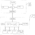
图1是本发明交互式的行车导航和车载安防系统的优选实施例的结构示意图;Fig. 1 is the structural representation of the preferred embodiment of interactive driving navigation and vehicle security system of the present invention;
图2是本发明交互式的行车导航和车载安防系统的各部分间交互数据的示意图;Fig. 2 is a schematic diagram of interactive data between various parts of the interactive driving navigation and vehicle security system of the present invention;
图3是本发明交互式的行车导航和车载安防系统中的用户终端的物理结构图;Fig. 3 is the physical structure diagram of the user terminal in the interactive driving navigation and vehicle security system of the present invention;
图4是本发明交互式的行车导航和车载安防方法的流程图。Fig. 4 is a flow chart of the interactive driving navigation and vehicle security method of the present invention.
具体实施方式 Detailed ways
基于GPS定位和导航、GIS、移动通信技术(如GSM、GPRS和CDMA等)、短距连接技术(如串口、红外、Bluetooth等)等技术,本发明将远程控制中心、车载终端、导航仪三者的功能整合,组成一种交互式的行车导航和车载安防系统。下面将分别说明远程控制中心、车载终端、导航仪三者的构成和功能。Based on technologies such as GPS positioning and navigation, GIS, mobile communication technology (such as GSM, GPRS and CDMA, etc.), short-distance connection technology (such as serial port, infrared, Bluetooth, etc.), the present invention combines remote control center, vehicle-mounted terminal, navigator three The function integration of the former constitutes an interactive driving navigation and vehicle security system. The composition and functions of the remote control center, vehicle-mounted terminal and navigator will be described respectively below.
远程控制中心remote control center
远程控制中心由呼叫中心、智能信息系统、地理信息系统等几部分组成。呼叫中心为系统提供一个友好的交互界面,并直接与车载终端进行信息沟通;地理信息系统整合和分析所有地理信息和数据(电子地图、周边信息等)、天气信息、实时交通信息(车祸、车流量、拥堵等)和道路状况(修路、积水等),生成简洁的关于事件描述、天气状况、影响程度、方向和范围、持续时间、路径规划建议等的数据;智能信息系统自动规范和存储地理信息系统的结果数据,并为呼叫中心提供数据支持。The remote control center is composed of call center, intelligent information system, geographic information system and other parts. The call center provides a friendly interactive interface for the system and communicates directly with the vehicle terminal; the geographic information system integrates and analyzes all geographic information and data (electronic maps, surrounding information, etc.), weather information, real-time traffic information (car accidents, Traffic, congestion, etc.) and road conditions (road repairs, water accumulation, etc.), generate concise data about event descriptions, weather conditions, impact levels, directions and ranges, durations, route planning suggestions, etc.; intelligent information systems automatically regulate and Store the result data of the geographic information system and provide data support for the call center.
车载终端vehicle terminal
车载终端利用其手柄、移动通信模块、GPS定位模块等设备,直接与远程控制中心交互实现车辆的定位和安全防卫工作。其中移动通信模块可采取GSM、GRPS或CDMA等移动通信方式。由于车载终端具有移动通信功能,所以也可以仅作为一个通信传输中介,通过其与导航仪的数据接口,利用导航仪丰富的功能和友好的用户界面与控制中心交互,实现其服务功能。车载终端与导航仪之间的数据接口可采用232串口等有线连接技术或Bluetooth等无线连接技术来实现。The vehicle-mounted terminal uses its handle, mobile communication module, GPS positioning module and other equipment to directly interact with the remote control center to realize vehicle positioning and security defense. Among them, the mobile communication module can adopt mobile communication methods such as GSM, GRPS or CDMA. Since the vehicle-mounted terminal has a mobile communication function, it can also only be used as a communication transmission intermediary. Through its data interface with the navigator, the rich functions and friendly user interface of the navigator can be used to interact with the control center to realize its service function. The data interface between the vehicle terminal and the navigator can be realized by wired connection technologies such as 232 serial ports or wireless connection technologies such as Bluetooth.
导航仪GPS
导航仪自带有静态GPS导航、影音播放等功能,并有与车载终端进行数据传输的接口(可采用232串口等有线连接技术或Bluetooth等无线连接技术实现)。导航仪使用者可以使用导航仪自带的静态的导航功能,可以仅接受控制中心传输的数据实施被动式的GPS导航,也可以与中心交互实施交互式动态导航。同时,导航仪可以接收和显示车载的安防、电话、短信等功能信息,并处理和显示控制中心结果数据。The navigator comes with functions such as static GPS navigation, audio and video playback, and an interface for data transmission with the vehicle terminal (which can be realized by using wired connection technologies such as 232 serial ports or wireless connection technologies such as Bluetooth). Navigator users can use the static navigation function that comes with the navigator, can only accept the data transmitted by the control center to implement passive GPS navigation, and can also interact with the center to implement interactive dynamic navigation. At the same time, the navigator can receive and display vehicle security, telephone, SMS and other functional information, and process and display the result data of the control center.
在交互式的行车导航和车载安防系统中,独立的车载终端和导航仪通过数据接口(有线或无线连接方式)组成用户终端,用户终端通过移动通信网络(GSM、GPRS、CDMA等)与远程控制中心交互。In the interactive driving navigation and vehicle security system, the independent vehicle terminal and the navigator form the user terminal through the data interface (wired or wireless connection mode), and the user terminal communicates with the remote control system through the mobile communication network (GSM, GPRS, CDMA, etc.) Center interaction.
在本发明的优选实施例中,以GPS定位和导航、GIS、GPRS/GSM通信网络、Bluetooth无线连接技术的应用为基础,在现有静态导航和车载安全防护远程控制的基础上,将远程控制中心、车载安防和智能导航仪三者结合起来,构成交互式的行车导航和车载安防系统,其体系结构如图1所示。In a preferred embodiment of the present invention, based on the application of GPS positioning and navigation, GIS, GPRS/GSM communication network, and Bluetooth wireless connection technology, on the basis of existing static navigation and remote control of vehicle safety protection, the remote control Center, vehicle security and intelligent navigator are combined to form an interactive driving navigation and vehicle security system, and its architecture is shown in Figure 1.
导航仪与车载终端(图1中为小汽车)通过Bluetooth实现一体化连接以组成用户终端,位于太空的GPS卫星不断的发射空间信息,安装在用户终端的GPS接收模块接收卫星信息,由用户终端的处理器处理GPS接收模块输出的信号,从中提取所需要的位置、速度和时间等数据。此时,用户终端可以利用其已有的电子地图完成静态导航功能。The navigator and the vehicle-mounted terminal (the car in Figure 1) realize an integrated connection through Bluetooth to form a user terminal. The GPS satellites in space continuously transmit space information, and the GPS receiving module installed in the user terminal receives satellite information, and the user terminal The processor processes the signal output by the GPS receiving module, and extracts the required data such as position, speed and time from it. At this time, the user terminal can use its existing electronic map to complete the static navigation function.
远程控制中心通过GPRS/GSM将中心整合的各种实时数据动态传输到用户终端,用户终端设备可结合这些数据利用其自带的GPS导航功能实现被动式动态导航,也可以反馈信息给控制中心,与其进行信息沟通,实现交互式动态导航和安防。The remote control center dynamically transmits various real-time data integrated by the center to the user terminal through GPRS/GSM. The user terminal device can combine these data and use its own GPS navigation function to realize passive dynamic navigation, and can also feed back information to the control center. Carry out information communication, realize interactive dynamic navigation and security.
本发明提出的交互式动态导航和安防系统中,用户终端可以在接收到实时动态数据后,对其进行反馈,向远程控制中心提出其个性要求。远程控制中心收到用户终端的反馈信息后,利用其集中、强大的数据处理功能和宽广、完善、实时的信息资源,为用户规划路径、处理个性化需求等,并直接将服务提供给用户。In the interactive dynamic navigation and security system proposed by the present invention, after receiving real-time dynamic data, the user terminal can give feedback to the real-time dynamic data and put forward its individual requirements to the remote control center. After receiving the feedback information from the user terminal, the remote control center uses its centralized and powerful data processing function and broad, perfect and real-time information resources to plan routes for users, handle individual needs, etc., and directly provide services to users.
如图2所示,本发明交互式的动态式的导航和安防系统中各部分间交互数据的示意图。其系统功能作用描述如下:As shown in FIG. 2 , it is a schematic diagram of interactive data among various parts in the interactive dynamic navigation and security system of the present invention. Its system functions are described as follows:
导航仪与车载终端通过Bluetooth无线连接技术组成可自由交互的用户终端。导航仪可以通过图像显示和语音提示的方式得到车载终端的GPRS/GSM(如电话、短信、安防信息等)功能,并可以通过触摸式屏幕直接操作和使用车载终端上的各种功能。The navigator and the vehicle terminal form a freely interactive user terminal through the Bluetooth wireless connection technology. The navigator can obtain the GPRS/GSM (such as telephone, SMS, security information, etc.) functions of the vehicle terminal through image display and voice prompts, and can directly operate and use various functions on the vehicle terminal through the touch screen.
在城市各地所设的信息采集点收集实时交通数据,交由远程控制中心运用GIS和智能信息处理系统对数据进行整理和存储,在中心地图信息中加入实时交通和道路状况、气象、新闻和音乐等数据,然后整合和实时更新控制中心的原始信息。Collect real-time traffic data at the information collection points set up around the city, send it to the remote control center to use GIS and intelligent information processing system to organize and store the data, and add real-time traffic and road conditions, weather, news and music to the central map information and other data, and then integrate and update the original information in the control center in real time.
导航仪和车台的定位、路径要求、安防及其它个性化的需求等“用户信息”通过车载终端的GPRS/GSM将数据上传至远程控制中心。"User information" such as the positioning of the navigator and the vehicle station, route requirements, security and other personalized requirements are uploaded to the remote control center through the GPRS/GSM of the vehicle terminal.
远程控制中心接受并实时处理导航仪使用者上传的用户信息,利用中心的强大的数据处理功能和完全、丰富、实时的信息资源,将中心的信息和导航仪使用者上传的用户信息结合起来进行综合处理,为终端用户整合路径规划、分流方向、替选路线、安防布置等“服务建议”。The remote control center accepts and processes user information uploaded by navigator users in real time, and uses the center's powerful data processing functions and complete, rich, and real-time information resources to combine the center's information with user information uploaded by navigator users. Comprehensive processing, integrating "service suggestions" such as route planning, diversion direction, alternative routes, and security arrangements for end users.
远程控制中心将整合的“服务建议”作为一个可视的或语音信息,通过车载终端的GPRS通信功能,提供给终端用户。The remote control center provides the integrated "service suggestion" as a visual or voice message to the end user through the GPRS communication function of the vehicle terminal.
从上面的数据流程描述可以看出,本发明提出的交互式的安防和动态导航系统,其优势主要表现为如下几点:As can be seen from the above data flow description, the advantages of the interactive security and dynamic navigation system proposed by the present invention are mainly as follows:
1、导航仪与车载终端既可以分离使用,也可实现一体化连接。1. The navigator and the vehicle terminal can be used separately or integrated.
2、原车台终端用户可以享受动态显示、语音提示、触摸控制等更为友好的交互界面。2. The terminal users of the original car station can enjoy more friendly interactive interfaces such as dynamic display, voice prompts, and touch control.
3、导航仪与远程控制中心连接交互,可实时更新其数据,并且可以直接使用控制中心提供的更为详实的数据,不必占用其自身资源。3. The navigator interacts with the remote control center to update its data in real time, and can directly use the more detailed data provided by the control center without occupying its own resources.
4、远程控制中心集中和整合系统所有资源,使得系统的信息更为完善,数据更为准确,功能更为强大,同时,也可减低系统成本,扩展系统数据累积范围。4. The remote control center concentrates and integrates all resources of the system, making the information of the system more complete, the data more accurate, and the functions more powerful. At the same time, it can also reduce system costs and expand the scope of system data accumulation.
5、终端用户只需提出要求,无需亲自规划和处理各种数据,可直接享受专业的服务。5. End users only need to make requests, and can directly enjoy professional services without planning and processing various data in person.
本发明的优选实施例在图1所示的体系结构的整体架构下,利用各种硬件、软件和协议实现交互式动态导航。主要着重于用户终端的一体化实现。The preferred embodiment of the present invention utilizes various hardware, software and protocols to realize interactive dynamic navigation under the overall framework of the architecture shown in FIG. 1 . It mainly focuses on the integration of user terminals.
在本发明的优选实施例中,用户终端的车载终端和导航仪的物理实现和连接如图3所示。车载终端以高速CPU为核心,通过串口扩展技术分别与GPS模块、手机模块、Bluetooth模块和手柄进行通信。GPS模块主要用于处理天线接收到的信号并传递给CPU,最终得到出车台位置的经纬度,实现车台的准确定位;手机模块用于GSM/GPRS/CDMA短消息及电话服务,实现与远程控制中心的通信;Bluetooth模块用于和带有Bluetooth功能的导航仪进行通信;而手柄则用于车载终端的拨号、显示短消息及操作其他控制命令,使车载终端可以与导航仪分离使用。另外,车载终端选用CPLD(Complex Programmable LogicDevice,复杂可编程逻辑控制器)扩展多个数量的IO接口,用于汽车油路检测、报警检测、灯检测、锁油门控制及其他安防控制。In the preferred embodiment of the present invention, the physical realization and connection of the vehicle terminal of the user terminal and the navigator are shown in FIG. 3 . The vehicle-mounted terminal takes the high-speed CPU as the core, and communicates with the GPS module, mobile phone module, Bluetooth module and the handle through the serial port expansion technology. The GPS module is mainly used to process the signal received by the antenna and transmit it to the CPU, and finally obtain the latitude and longitude of the location of the vehicle platform, so as to realize the accurate positioning of the vehicle platform; the mobile phone module is used for GSM/GPRS/CDMA short message and telephone service, to realize communication The communication of the control center; the Bluetooth module is used to communicate with the navigator with Bluetooth function; the handle is used for dialing, displaying short messages and operating other control commands of the vehicle terminal, so that the vehicle terminal can be used separately from the navigator. In addition, the vehicle-mounted terminal uses CPLD (Complex Programmable Logic Device, complex programmable logic controller) to expand multiple numbers of IO interfaces for automotive oil circuit detection, alarm detection, light detection, throttle lock control and other security controls.
导航仪采用双CPU架构,以一个32位处理器(如三星2410)为主,一个16位处理器(如MSP430)为辅,进行高速信号处理及与车台之间的通信,同时,采用多片Synchronous DRAM(同步动态随机访问存储器)(如HY57V561620)构成128M或者更高内存,以保证系统高速运行。GPS模块处理接收到GPS定位信息,将其传输给CPU。CPU可结合地图、计算等软件进行数据处理。导航仪运行的操作系统(如WINCE)可烧录在Flash(闪存)或者微硬盘中。同时,导航仪还配置有触摸式屏幕、SD(安全数码记忆卡)卡及USB(通用串行总线)接口等输入输出设备,可实现系统升级及与其他设备的数据交换。The navigator adopts a dual-CPU architecture, mainly based on a 32-bit processor (such as Samsung 2410), supplemented by a 16-bit processor (such as MSP430), for high-speed signal processing and communication with the vehicle. One piece of Synchronous DRAM (Synchronous Dynamic Random Access Memory) (such as HY57V561620) constitutes 128M or higher memory to ensure high-speed operation of the system. The GPS module processes the received GPS positioning information and transmits it to the CPU. The CPU can be combined with software such as maps and calculations for data processing. The operating system (such as WINCE) that the navigator runs can be burned in Flash (flash memory) or micro-hard disk. At the same time, the navigator is also equipped with input and output devices such as touch screen, SD (Secure Digital Memory Card) card and USB (Universal Serial Bus) interface, which can realize system upgrade and data exchange with other devices.
用户终端使用的协议主要包括如GPRS通信协议、GPS卫星接收协议、Bluetooth标准、USB接口标准等传输协议,这些协议为系统信息沟通提供了依据。The protocols used by user terminals mainly include transmission protocols such as GPRS communication protocol, GPS satellite receiving protocol, Bluetooth standard, USB interface standard, etc. These protocols provide the basis for system information communication.
软件主要包括导航软件、接口驱动软件和辅助软件等。导航软件包括GPS定位显示、模拟导航和真实导航、目的地检索和区域或类别检索、动态信息数据处理、解码及路径规划等功能;接口驱动软件包括SD卡、USB和AV输入输出等驱动软件,为主机与外设提供链接;辅助软件指实现影视、音乐的播放,图片浏览、电子书查阅等多种功能的软件。The software mainly includes navigation software, interface driver software and auxiliary software. Navigation software includes functions such as GPS positioning display, simulated navigation and real navigation, destination retrieval and area or category retrieval, dynamic information data processing, decoding and route planning; interface driver software includes SD card, USB and AV input and output driver software, Provide links for the host and peripherals; auxiliary software refers to software that realizes various functions such as video, music playback, picture browsing, and e-book viewing.
本发明提供了一种交互式的行车导航和车载安防方法,如图4所示,该方法包括如下步骤:The present invention provides an interactive driving navigation and vehicle security method, as shown in Figure 4, the method includes the following steps:
用户终端使用导航仪触摸屏上的按键,向远程控制中心发送“服务请求”,“服务请求”可以选择人工服务或自动智能服务;The user terminal uses the buttons on the touch screen of the navigator to send a "service request" to the remote control center, and the "service request" can choose manual service or automatic intelligent service;
远程控制中心接受请求,并回复“接受服务”,建立用户终端和远程控制中心间的服务连接;The remote control center accepts the request and replies "accept service" to establish a service connection between the user terminal and the remote control center;
用户终端将其从GPS卫星提取的位置、速度和时间等数据,上传至远程控制中心,实现车辆的安全防卫功能;The user terminal uploads the data such as position, speed and time extracted from the GPS satellite to the remote control center to realize the vehicle's security defense function;
远程控制中心将其获得的实时交通和道路状况、气象、新闻和音乐等动态数据发送至用户终端,更新用户终端的数据;The remote control center sends dynamic data such as real-time traffic and road conditions, weather, news and music to the user terminal to update the data of the user terminal;
用户向控制中心提出关于“路径规划”的个性要求(目的的、最短时间优先、回避地等),并对远程控制中心发送的动态数据给出反馈和评价意见;The user puts forward individual requirements for "route planning" (purpose, shortest time priority, avoidance, etc.) to the control center, and gives feedback and evaluation opinions on the dynamic data sent by the remote control center;
远程控制中心接收并实时处理用户需求和意见,将整合的“路径规划”结果,作为一个可视的或语音信息,提供给终端用户;The remote control center receives and processes user needs and opinions in real time, and provides the integrated "route planning" results as visual or voice information to end users;
终端用户如果对远程控制中心的服务满意,则这完成其与控制中心的交互,根据实时数据实施动态导航,否则,将其意见和要求反馈,重复5、6的操作继续交互,直至达到终端用户的目标。If the end user is satisfied with the service of the remote control center, then the interaction with the control center will be completed, and dynamic navigation will be implemented according to the real-time data; otherwise, the feedback of their opinions and requirements will be repeated, and the operations of 5 and 6 will continue until the end user is reached. The goal.
在本发明中,导航仪和车载终端用户通过移动通信网络和短距连接技术在导航过程中随时与远程控制中心交互,及时交流获得和更新实时导航和安防信息,并由远程控制中心设计导航和安防方案,真正的实现可远程交互的车载安防和动态导航,既可保护终端用户生命和财产安全,又可节约个人和社会资源。In the present invention, the navigator and the vehicle-mounted terminal user interact with the remote control center at any time during the navigation process through the mobile communication network and short-distance connection technology, communicate in time to obtain and update real-time navigation and security information, and the remote control center designs navigation and The security solution can truly realize remote interactive vehicle security and dynamic navigation, which can not only protect the life and property of end users, but also save personal and social resources.
Claims (10)
Priority Applications (1)
| Application Number | Priority Date | Filing Date | Title |
|---|---|---|---|
| CNB2006101570277A CN100533503C (en) | 2006-11-23 | 2006-11-23 | An interactive driving navigation and vehicle security system |
Applications Claiming Priority (1)
| Application Number | Priority Date | Filing Date | Title |
|---|---|---|---|
| CNB2006101570277A CN100533503C (en) | 2006-11-23 | 2006-11-23 | An interactive driving navigation and vehicle security system |
Publications (2)
| Publication Number | Publication Date |
|---|---|
| CN1967615A CN1967615A (en) | 2007-05-23 |
| CN100533503C true CN100533503C (en) | 2009-08-26 |
Family
ID=38076367
Family Applications (1)
| Application Number | Title | Priority Date | Filing Date |
|---|---|---|---|
| CNB2006101570277A Expired - Fee Related CN100533503C (en) | 2006-11-23 | 2006-11-23 | An interactive driving navigation and vehicle security system |
Country Status (1)
| Country | Link |
|---|---|
| CN (1) | CN100533503C (en) |
Families Citing this family (10)
| Publication number | Priority date | Publication date | Assignee | Title |
|---|---|---|---|---|
| CN101183011B (en) * | 2007-12-27 | 2011-08-31 | 深圳市赛格导航科技股份有限公司 | GPS navigation method and system |
| CN101806597B (en) * | 2009-02-13 | 2012-12-12 | 深圳市赛格导航科技股份有限公司 | Intelligent information system-based remote interactive navigation method and system |
| CN101881621B (en) * | 2009-05-07 | 2012-10-03 | 深圳市赛格导航科技股份有限公司 | Omnibearing security and real-time navigation system supporting source sharing |
| JP5448626B2 (en) * | 2009-07-31 | 2014-03-19 | クラリオン株式会社 | Navigation device, server device, and navigation system |
| CN102117547A (en) * | 2009-12-31 | 2011-07-06 | 上海博泰悦臻电子设备制造有限公司 | Business processing method of vehicle service system |
| US8731627B2 (en) * | 2011-04-04 | 2014-05-20 | General Motors Llc | Method of using a smart phone as a telematics device interface |
| CN102975632A (en) * | 2011-09-02 | 2013-03-20 | 杭州鸿泉数字设备有限公司 | Vehicle remote management control achieving device |
| CN102853841A (en) * | 2012-05-08 | 2013-01-02 | 龚䶮 | The Human-Computer Interaction Method of Navigator |
| CN103884349A (en) * | 2014-02-21 | 2014-06-25 | 武汉无懈科技有限责任公司 | Evaluation-based navigation method |
| CN105466450A (en) * | 2015-11-21 | 2016-04-06 | 广西南宁至简至凡科技咨询有限公司 | GPS-based train journey measuring system |
-
2006
- 2006-11-23 CN CNB2006101570277A patent/CN100533503C/en not_active Expired - Fee Related
Also Published As
| Publication number | Publication date |
|---|---|
| CN1967615A (en) | 2007-05-23 |
Similar Documents
| Publication | Publication Date | Title |
|---|---|---|
| Yang et al. | Emerging technologies for 5G-enabled vehicular networks | |
| Chen et al. | Cellular vehicle-to-everything (C-V2X) | |
| RU2571450C2 (en) | Method of multimodal navigation | |
| CN101489196A (en) | Intelligent vehicle-mounted system | |
| CN205265929U (en) | OBU system that a lot of net inserted in networking of 5G car | |
| Wevers et al. | V2X communication for ITS-from IEEE 802.11 p towards 5G | |
| CN101086806A (en) | A system and method for onboard terminal based on traffic information grid platform | |
| CN102819961B (en) | Traffic signal real-time transmission system on basis of wireless mobile communication network | |
| CN100533503C (en) | An interactive driving navigation and vehicle security system | |
| CN104408965B (en) | Based on VANET destinations, nearby parking lot information obtains DSS | |
| CN106781582A (en) | Traffic lights auxiliary display method, device and car-mounted terminal | |
| CN102280037A (en) | Traffic information release method based on ZigBee network | |
| CN103888514A (en) | Intelligent vehicle-mounted information service system based on Ad Hoc network | |
| CN109874109A (en) | Mobile unit and its service information pushing method | |
| CN101039476B (en) | Method and system for helping others navigation through mobile phone | |
| CN109243191A (en) | Information push method and device | |
| CN205788804U (en) | Vehicle short-distance wireless communication anticollision on-vehicle terminal device | |
| CN106169259A (en) | Vehicle short-distance wireless communication anticollision on-vehicle terminal device | |
| CN101881621B (en) | Omnibearing security and real-time navigation system supporting source sharing | |
| CN110133687A (en) | A novel shuttle positioning system and method | |
| Urra et al. | An approach driven by mobile agents for data management in vehicular networks | |
| CN201600144U (en) | GPS navigator capable of providing real-time road condition information | |
| Du | Internet of vehicles | |
| CN104715601A (en) | Intelligent traffic glasses and working method thereof | |
| Fantian et al. | Review of the key technologies and applications in internet of vehicle |
Legal Events
| Date | Code | Title | Description |
|---|---|---|---|
| C06 | Publication | ||
| PB01 | Publication | ||
| C10 | Entry into substantive examination | ||
| SE01 | Entry into force of request for substantive examination | ||
| C14 | Grant of patent or utility model | ||
| GR01 | Patent grant | ||
| CF01 | Termination of patent right due to non-payment of annual fee |
Granted publication date: 20090826 |
|
| CF01 | Termination of patent right due to non-payment of annual fee |