KR20140089537A - Geo-fence based on geo-tagged media - Google Patents
Geo-fence based on geo-tagged media Download PDFInfo
- Publication number
- KR20140089537A KR20140089537A KR1020147012424A KR20147012424A KR20140089537A KR 20140089537 A KR20140089537 A KR 20140089537A KR 1020147012424 A KR1020147012424 A KR 1020147012424A KR 20147012424 A KR20147012424 A KR 20147012424A KR 20140089537 A KR20140089537 A KR 20140089537A
- Authority
- KR
- South Korea
- Prior art keywords
- user
- geotagged
- geofence
- item
- virtual boundary
- Prior art date
Links
- 230000009471 action Effects 0.000 claims abstract description 20
- 230000001960 triggered effect Effects 0.000 claims abstract description 10
- 238000000605 extraction Methods 0.000 claims abstract description 6
- 238000000034 method Methods 0.000 claims description 36
- 230000004044 response Effects 0.000 claims description 3
- 230000000977 initiatory effect Effects 0.000 claims 1
- 239000000284 extract Substances 0.000 abstract description 4
- 238000007796 conventional method Methods 0.000 abstract description 2
- 238000004891 communication Methods 0.000 description 9
- 238000010586 diagram Methods 0.000 description 7
- 238000012545 processing Methods 0.000 description 6
- 238000005516 engineering process Methods 0.000 description 5
- 230000006855 networking Effects 0.000 description 3
- 230000003287 optical effect Effects 0.000 description 3
- 238000013461 design Methods 0.000 description 2
- 230000006870 function Effects 0.000 description 2
- 238000012986 modification Methods 0.000 description 2
- 230000004048 modification Effects 0.000 description 2
- 230000002093 peripheral effect Effects 0.000 description 2
- 230000008569 process Effects 0.000 description 2
- 239000007787 solid Substances 0.000 description 2
- 230000007246 mechanism Effects 0.000 description 1
- 230000002085 persistent effect Effects 0.000 description 1
- 230000003068 static effect Effects 0.000 description 1
- 239000000758 substrate Substances 0.000 description 1
Images


Classifications
-
- G—PHYSICS
- G06—COMPUTING; CALCULATING OR COUNTING
- G06F—ELECTRIC DIGITAL DATA PROCESSING
- G06F16/00—Information retrieval; Database structures therefor; File system structures therefor
- G06F16/40—Information retrieval; Database structures therefor; File system structures therefor of multimedia data, e.g. slideshows comprising image and additional audio data
- G06F16/48—Retrieval characterised by using metadata, e.g. metadata not derived from the content or metadata generated manually
- G06F16/487—Retrieval characterised by using metadata, e.g. metadata not derived from the content or metadata generated manually using geographical or spatial information, e.g. location
-
- G—PHYSICS
- G06—COMPUTING; CALCULATING OR COUNTING
- G06F—ELECTRIC DIGITAL DATA PROCESSING
- G06F16/00—Information retrieval; Database structures therefor; File system structures therefor
- G06F16/50—Information retrieval; Database structures therefor; File system structures therefor of still image data
- G06F16/58—Retrieval characterised by using metadata, e.g. metadata not derived from the content or metadata generated manually
-
- G—PHYSICS
- G06—COMPUTING; CALCULATING OR COUNTING
- G06F—ELECTRIC DIGITAL DATA PROCESSING
- G06F9/00—Arrangements for program control, e.g. control units
- G06F9/06—Arrangements for program control, e.g. control units using stored programs, i.e. using an internal store of processing equipment to receive or retain programs
- G06F9/44—Arrangements for executing specific programs
-
- G—PHYSICS
- G06—COMPUTING; CALCULATING OR COUNTING
- G06F—ELECTRIC DIGITAL DATA PROCESSING
- G06F17/00—Digital computing or data processing equipment or methods, specially adapted for specific functions
-
- G—PHYSICS
- G01—MEASURING; TESTING
- G01S—RADIO DIRECTION-FINDING; RADIO NAVIGATION; DETERMINING DISTANCE OR VELOCITY BY USE OF RADIO WAVES; LOCATING OR PRESENCE-DETECTING BY USE OF THE REFLECTION OR RERADIATION OF RADIO WAVES; ANALOGOUS ARRANGEMENTS USING OTHER WAVES
- G01S19/00—Satellite radio beacon positioning systems; Determining position, velocity or attitude using signals transmitted by such systems
- G01S19/01—Satellite radio beacon positioning systems transmitting time-stamped messages, e.g. GPS [Global Positioning System], GLONASS [Global Orbiting Navigation Satellite System] or GALILEO
- G01S19/13—Receivers
- G01S19/14—Receivers specially adapted for specific applications
Landscapes
- Engineering & Computer Science (AREA)
- Theoretical Computer Science (AREA)
- Physics & Mathematics (AREA)
- General Engineering & Computer Science (AREA)
- General Physics & Mathematics (AREA)
- Databases & Information Systems (AREA)
- Software Systems (AREA)
- Data Mining & Analysis (AREA)
- Library & Information Science (AREA)
- Mathematical Physics (AREA)
- Multimedia (AREA)
- Management, Administration, Business Operations System, And Electronic Commerce (AREA)
- Mobile Radio Communication Systems (AREA)
- Information Transfer Between Computers (AREA)
Abstract
개시되어 있는 아키텍처는 지오 태그형 아이템(예를 들어, 사진)에 기초하여 지오 펜스를 생성한다. 지오 태그형 아이템은 디지털 매체를 공유하기 위한 종래의 방법(예를 들어, 이메일)을 통해 사용자들 간의 가상 경계, 예를 들어 지오 펜스를 공유하는데 사용될 수 있다. 추출 컴포넌트는 지오 태그형 아이템의 지오로케이션 정보(예를 들어, 위도 및 경도 좌표, 고도, 방향, 거리, 지명 등)를 추출한다. 지오로케이션 정보는 아이템이 지오 태그되는 지리적 위치에 관한 것일 수 있다. 경계 컴포넌트는 지리적 위치와 연계하여 그리고 지오로케이션 정보에 기초하여 가상 경계(예를 들어, 지오 펜스)를 생성한다. 이후, 가상 경계는 사용자가 가상 경계를 가로지르는(예를 들어, 인게이지(engage), 교차하는) 경우 트리거되고 첨부된 액션이 트리거된다. 지오 태그형 아이템은 또 다른 사용자와 공유될 수 있는데, 이 지오 태그형 아이템은 처리되는 경우 그 또 다른 사용자를 위한 가상 경계를 생성한다.The disclosed architecture generates a geofence based on a geotagged item (e.g., a photograph). Geotagged items can be used to share virtual boundaries between users, e. G., Geofences, via conventional methods (e. G., E-mail) for sharing digital media. The extraction component extracts geolocation information (e.g., latitude and longitude coordinates, elevation, direction, distance, location name, etc.) of the geotagged item. The geolocation information may relate to the geographic location at which the item is geotagged. The boundary component creates a virtual boundary (e.g., a geofence) in conjunction with the geographic location and based on the geolocation information. The virtual boundary is then triggered when the user traverses the virtual boundary (e.g., engage, intersect) and the attached action is triggered. A geotagged item can be shared with another user, which, when processed, creates a virtual boundary for that other user.
Description
지오-태깅(geo-tagging)은 GPS(global positioning system)와 같은 지오로케이션 시스템(geolocation system)으로부터의 지리적 메타데이터(예를 들어, 위도 및 경도 좌표)를 매체에 덧붙이는 프로세스이다. 카메라 및 모바일 장치(예를 들어, 이동 전화기)는 사진이 찍히는 물리적 위치의 지리적 좌표를 포함하는 지오-태그형(geo-tagged) 사진을 찍을 수 있다. 또한, 지오 펜스(geo-fences)는 소정의 지리적 위치에 대한 리마인더(reminders)를 개시하는 메카니즘으로서 점점 인기를 얻고 있다. 그러나, 사진 위치에 기초하여 지오 펜스를 생성하기 위해, 기존의 기법들은 몇몇 별개의 도구들을 사용해야 한다. 즉, 지오 태그형 사진으로부터 지오 펜스를 생성하기 위한 단일 단계 솔루션은 존재하지 않는다.
Geo-tagging is the process of appending geographic metadata (e.g., latitude and longitude coordinates) from a geolocation system, such as a global positioning system (GPS), to a medium. The camera and the mobile device (e. G., A mobile phone) can take a geo-tagged picture that includes the geographical coordinates of the physical location at which the picture is taken. In addition, geo-fences are becoming increasingly popular as a mechanism to initiate reminders for certain geographic locations. However, in order to create a geofence based on the photographic location, existing techniques must use some discrete tools. That is, there is no single step solution for generating geofences from geotagged photographs.
이하에서는 본 명세서에서 기술되는 몇몇 신규 실시예들의 기본적인 이해를 제공하기 위한 간단한 요약이 제시된다. 본 요약은 광범위한 개요는 아니며, 본 발명의 주된 사항/핵심 사항을 밝히거나 본 발명의 범주를 기술하려는 것은 아니다. 본 요약의 유일한 목적은 이하에서 제시되는 보다 상세한 설명에 대한 서론으로서 몇몇 개념들을 간단한 형태로 제시하려는 것이다. A brief summary is provided below to provide a basic understanding of some of the novel embodiments described herein. This summary is not an extensive overview and is not intended to identify key / critical issues of the invention or to delineate the scope of the invention. The sole purpose of this summary is to present some concepts in a simplified form as an introduction to the more detailed description presented below.
개시되어 있는 아키텍처는 지오 태그형 아이템(예를 들어, 사진, 웹사이트, 문서, 메시지, 피드 등)에 기초하여 지오 펜스를 단일 단계로 생성한다. 또한, 지오 태그형 아이템은 디지털 매체를 공유하기 위한 종래의 방법(예를 들어, 이메일)을 통해 사용자들 간의 가상 경계, 예를 들어 지오 펜스를 공유하는데 사용될 수 있다.The disclosed architecture creates geofences in a single step based on geotagged items (e.g., photographs, websites, documents, messages, feeds, etc.). The geotagged items can also be used to share virtual boundaries between users, e. G., Geofences, via conventional methods (e. G., E-mail) for sharing digital media.
일반적으로, 아키텍처는 지오 태그형 아이템의 지오로케이션 정보(예를 들어, 위도 및 경도 좌표, 고도, 방향, 거리, 지명 등)를 추출하는 추출 컴포넌트를 포함할 수 있다. 지오로케이션 정보는 아이템이 지오 태그되는 지리적 위치에 관한 것일 수 있다. 경계 컴포넌트는 지리적 위치와 연계하여 그리고 지오로케이션 정보에 기초하여 가상 경계(예를 들어, 지오 펜스)를 생성한다.In general, the architecture may include an extraction component that extracts geolocation information (e.g., latitude and longitude coordinates, elevation, direction, distance, location, etc.) of the geotagged item. The geolocation information may relate to the geographic location at which the item is geotagged. The boundary component creates a virtual boundary (e.g., a geofence) in conjunction with the geographic location and based on the geolocation information.
사진의 맥락에서, 지오 태깅 가능 카메라 또는 전화기가 특정 지리적 위치에서 사진(예를 들어, 만남의 장소의 사진)을 찍는데 사용될 수 있다. 지오로케이션 정보는 사진으로부터 추출될 수 있다. 추출된 지리적 위치에 대한 지오 펜스가 정의된다. 예를 들어, 추출된 지리적 위치 주변에 X 미터의 직경을 갖는 원(또는 다른 기하학 구성)이 생성된다. 생성된 지오 펜스에 액션(예를 들어, 리마인더, 통보 등)이 첨부된다. 액션들은 지오 펜스 설명에 첨부된 메타데이터이다. 지오 펜스는 영구 저장소에 저장될 수 있다(예를 들어, 장치 상에 로컬로 저장 및/또는 외부 글로벌 데이터베이스에 저장될 수 있다). 이후, 지오 펜스는 사용자가 지오 펜스를 가로지르는(예를 들어, 인게이지(engage), 교차하는) 경우 트리거되고 첨부된 액션이 트리거된다(예를 들어, 지오 펜스를 트리거한 사용자 장치 또는 지오펜스를 트리거한 장치 이외의 다른 장치에 리마인더가 전송되고 제공된다). In the context of photography, geotagging cameras or telephones can be used to capture pictures (e.g., photographs of a meeting place) from a particular geographic location. Geolocation information can be extracted from the photograph. A geofence for the extracted geographic location is defined. For example, a circle (or other geometric configuration) with a diameter of X meters is created around the extracted geographic location. An action (for example, reminder, notification, etc.) is attached to the generated geofence. Actions are metadata attached to a geofence description. The geofence may be stored in a persistent store (e.g., stored locally on the device and / or stored in an external global database). The geofence is then triggered when the user traverses the geofence (e.g., engage, intersect) and the attached action is triggered (e.g., the user device that triggered the geofence or the geofence A reminder is sent and provided to a device other than the one that triggered the device).
사진은 이메일(또는 임의의 다른 공유 방법)을 사용하는 또 다른 사용자와 공유될 수 있다. 지오 태그형 사진을 수신하는 사용자는 전술한 기법을 사용하여 지오 펜스를 생성할 수 있다. 선택에 따라, 수행될 하나 이상의 지오 펜스 액션은 (예를 들어, 교환가능 이미지 파일 포맷(EXIF)을 사용하여) 사진 메타데이터에 내장될 수 있다. 선택에 따라, 내장된 지오 펜스 액션은 사진을 찍은 사용자 및/또는 사진을 수신하고 처리한 또 다른 사용자에 대해 생성된 지오 펜스에 첨부될 수 있다. 사진 메타데이터는 또한 개선된 보안을 위해 암호화 및/또는 복호화될 수 있다.Photos can be shared with another user using email (or any other sharing method). A user receiving a geotagged picture can generate a geofence using the techniques described above. Optionally, one or more geofence actions to be performed may be embedded in the photo metadata (e.g., using an exchangeable image file format (EXIF)). Optionally, the built-in geofence action may be attached to the geofence generated for the user who took the picture and / or another user who received and processed the picture. The photo metadata may also be encrypted and / or decrypted for improved security.
전술한 및 관련 목적을 달성하기 위해, 본 명세서에서는 후속하는 상세한 설명 및 첨부된 도면과 연계하여 소정의 예시적인 측면들이 설명된다. 이들 측면들은 본 명세서에서 개시된 원리들이 실시될 수 있는 다양한 방식을 나타내고 모든 측면 및 이들의 등가물은 청구 대상의 범주 내에 속하려 한다. 도면과 연계된 후속하는 상세한 설명으로부터 다른 장점 및 새로운 특징이 자명할 것이다.
To the accomplishment of the foregoing and related ends, certain illustrative aspects are described herein in connection with the following detailed description and the accompanying drawings. These aspects are indicative of the various ways in which the principles disclosed herein may be practiced and in all aspects and their equivalents, fall within the scope of the claims. Other advantages and novel features will become apparent from the following detailed description in conjunction with the drawings.
도 1은 개시되어 있는 아키텍처에 따른 시스템을 나타낸다.
도 2는 지오 태그형 아이템의 공유 및 활용을 용이하게 하는 시스템을 나타낸다.
도 3은 지오 태그형 아이템에 내장된 액션을 나타낸다.
도 4는 사용자 정보에 대한 승인된 및 보안 취급을 위한 보안 컴포넌트를 이용하는 시스템을 나타낸다.
도 5는 개시되어 있는 아키텍처에 따른 방법을 나타낸다.
도 6은 도 5의 방법의 또 다른 측면을 나타낸다.
도 7은 개시되어 있는 아키텍처에 따른 또 다른 방법을 나타낸다.
도 8은 도 7의 방법의 또 다른 측면을 나타낸다.
도 9는 개시되어 있는 아키텍처에 따라 지오 태그형 아이템에 기초하여 지오 펜스의 생성을 실행하는 컴퓨팅 시스템의 블록도를 나타낸다.Figure 1 shows a system according to the disclosed architecture.
Figure 2 shows a system that facilitates sharing and utilization of geotagged items.
Figure 3 shows the actions embedded in a geotagged item.
Figure 4 shows a system that uses security components for authorized and secure handling of user information.
Figure 5 illustrates a method according to the disclosed architecture.
Figure 6 shows another aspect of the method of Figure 5;
Figure 7 illustrates another method according to the disclosed architecture.
Figure 8 shows another aspect of the method of Figure 7;
9 shows a block diagram of a computing system that performs generation of a geofence based on a geotagged item in accordance with the disclosed architecture.
지오 펜스는 지리적 위치와 연계되어 생성된 가상 주변 또는 경계이다. 지오 펜스는 동적으로 생성될 수 있거나(예를 들어, 가게 주변의 반경), 또는 사전 정의된 경계 세트일 수 있다. 위치 기반 서비스와 연계하여 동작하는 사용자의 위치 인식 장치가 지오 펜스를 가로지르거나 인게이지하는 경우, 통보가 생성되고 (예를 들어, 전화, 이메일 등을 통해) 사용자에게 전송될 수 있다.A geofence is a virtual perimeter or boundary created in conjunction with a geographic location. A geofence may be generated dynamically (e.g., a radius around a store), or it may be a predefined set of boundaries. If the location-aware device of the user operating in conjunction with the location-based service is traversing or crossing the geofence, a notification can be generated and sent to the user (e.g. via phone, email, etc.).
개시되어 있는 아키텍처는 사진과 같은 지오 태그형 아이템에 기초한 지오 펜스의 생성을 용이하게 한다. 또한, 지오 태그형 아이템은 디지털 사진을 공유하기 위해 현재 이용되고 있는 모든 방법을 사용하여 사람들 간에 지오 펜스를 공유하는데 사용될 수 있다. 지오 태그형 아이템으로부터 지오로케이션 정보를 추출함으로써, 그 위치에 대한 지오 펜스가 생성될 수 있다.The disclosed architecture facilitates the creation of geofences based on geotagged items such as photographs. Geotagged items can also be used to share geofences between people using all the methods currently used to share digital photos. By extracting geolocation information from a geotagged item, a geofence for that location can be generated.
이제 도면들을 참조할 것이며, 이 도면들에서 유사한 요소들을 지칭하는데 유사한 참조 번호가 사용된다. 후속하는 상세한 설명에서, 설명을 위해, 본 발명의 완전한 이해를 제공하기 위해 다수의 특정 세부사항이 설명된다. 그러나, 신규한 실시예들은 이들 특정한 세부사항 없이도 실시될 수 있음은 자명하다. 다른 예로서, 잘 알려진 구조 및 장치는 설명을 용이하게 하기 위해 블록도 형태로 도시되어 있다. 본 발명은 청구 대상의 사상 및 범주 내의 모든 변경, 등가물 및 대안들을 커버하려 한다.Reference will now be made to the drawings, wherein like reference numerals are used to refer to like elements throughout. In the following detailed description, for purposes of explanation, numerous specific details are set forth in order to provide a thorough understanding of the present invention. It will be apparent, however, that the novel embodiments may be practiced without these specific details. As another example, well-known structures and devices are shown in block diagram form for ease of description. The present invention is intended to cover all modifications, equivalents, and alternatives falling within the spirit and scope of the claimed subject matter.
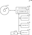
도 1은 개시되어 있는 아키텍처에 따른 시스템(100)을 나타낸다. 시스템(100)은 지오 태그형 아이템(106)의 지오로케이션 정보(104)를 추출하는 추출 컴포넌트(102)를 포함한다. 지오로케이션 정보(104)는 아이템(106)이 지오 태그되는 지리적 위치(108)에 관련된다. 경계 컴포넌트(110)는 지오로케이션 정보(104)에 기초한 지리적 위치(108)와 연관지어 가상 경계(112)를 생성한다.Figure 1 shows a
지오 태그 아이템(106)은 사진일 수 있다. 가상 경계(112)(경계 정보)는 사용자의 사용자 식별자와 연관지어 저장된다. 경계 컴포넌트(110)는 사용자의 위치 인식 장치에 의한 가상 경계(112)의 인게이지먼트에 응답하여 사용자와 연관된 액션(114)을 개시한다.The
도 2는 지오 태그형 아이템(106)의 공유 및 활용을 용이하게 하는 시스템(200)을 나타낸다. 지오 태그형 아이템(106)의 지오로케이션 정보의 추출에 기초하여, 제1 사용자(User1)에 대한 가상 경계(112)(예를 들어, 지오 펜스)가 생성된 후, 제1 사용자는 아이템(106)을 통신 프레임워크(202)(예를 들어, 이메일)를 통해 제2 사용자(User2)에 전송한다. 제2 사용자의 시스템 및/또는 장치는 지오 태그형 아이템(106)을 수신하고 그로부터 지오로케이션 정보(104)를 추출하고, 제2 사용자를 위한 동일한 또는 상이한 가상 경계(204)(명료성을 위해 오프셋됨)를 생성한다. 제1 사용자, 지오 태그형 아이템(106), 지오로케이션 정보(104) 및 가상 경계(112)의 관계(relationships)와, 제2 사용자, 지오 태그형 아이템(106), 지오로케이션 정보(104) 및 가상 경계(204)의 관계를 저장하기 위한 저장 시스템(206)이 제공된다. 가상 경계(112)는 다른(제2) 사용자와 연관된다.FIG. 2 illustrates a
도 3은 지오 태그형 아이템(106)에 내장된 액션(114)을 나타낸다. 지오 태그형 아이템(106)은 내장된 액션 정보를 구비한 사진일 수 있다. 내장된 액션(114)은 수신 사용자(제2 사용자)의 장치에 의해 처리되고 수신 사용자가 가상 경계를 인게이지한 것으로 검출되면 활성화된다. 내장된 액션(114)은 수신(제2) 사용자의 장치에 의해 처리되고 수신 사용자에 대해 생성된 가상 경계와 연관된다. 액션은 사용자 장치에 전송된 통보(예를 들어, 리마인더)일 수 있다.FIG. 3 shows an
도 4는 사용자의 정보의 허가된 및 안전한 취급을 위한 보안 컴포넌트(402)를 더 채용하는 시스템(400)을 나타낸다. 보안 컴포넌트(402)는 사용자가 지오로케이션 정보, 액선 및/또는 사용자에 대한 이러한 정보의 임의의 관계를 노출시킬지에 대해 옵트인 또는 옵트아웃할 수 있도록 해준다.4 shows a
개시되어 있는 아키텍처의 신규한 측면들을 수행하기 위한 예시적인 방법을 나타내는 흐름도가 본 명세서에 포함된다. 간단한 설명을 위해, 예를 들어 흐름도 형태로 도시되어 있는 하나 이상의 방법이 일련의 동작들로 도시되고 기술되어 있지만, 이들 방법은 그러한 동작 순서로 국한되지 않으며, 그에 따른 몇몇 동작들은 본 명세서에 도시되고 기술된 것과 다른 동작들과 상이한 순서로 및/또는 동시에 실행될 수 있음을 이해해야 한다. 예를 들어, 당업자라면 방법은 그와 달리 상태도와 같이 상호관련 있는 일련의 상태들 또는 이벤트들로 표현될 수 있음을 알 수 있을 것이다. 또한, 신규한 실시예들을 구현하기 위해 방법에 예시되어 있는 모든 동작들이 요구되는 것은 아닐 수 있다.A flow diagram illustrating an exemplary method for performing the novel aspects of the disclosed architecture is included herein. For the sake of brevity, although one or more methods, for example, shown in flow diagram form, are shown and described as a series of acts, these methods are not limited to such an order of operation, It is to be understood that the invention may be practiced in different orders and / or concurrently with other operations than those described. For example, one of ordinary skill in the art will recognize that a method may alternatively be represented by a series of mutually related states or events, such as a state diagram. In addition, not all of the operations illustrated in the method may be required to implement the novel embodiments.
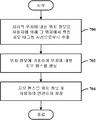
도 5는 개시되어 있는 아키텍처에 따른 방법을 나타낸다. 단계(500)에서, 위치에 대한 위치 정보가 지오 태그형 매체(예를 들어, 사진)로부터 추출된다. 단계(502)에서, 위치 정보에 기초하여 위치에 대한 지오 펜스가 생성된다.Figure 5 illustrates a method according to the disclosed architecture. At
도 6은 도 5의 방법의 추가적인 측면들을 나타낸다. 이 흐름도에서의 각 블록은 도 5의 흐름도에 의해 표현된 방법의 추가적인 측면으로서, 다른 블록들과 별개로 또는 연계되어 포함될 수 있는 단계를 나타낼 수 있다. 단계(600)에서, 지오 펜스가 트리거되는 경우 사용자에 대한 액션이 개시된다. 단계(602)에서, 지오 태그형 매체를 또 다른 사용자와 공유함으로써 또 다른 사용자에 대한 지오 펜스가 생성된다. 단계(604)에서, 지오 펜스는 위치 정보와 연관지어 (예를 들어, 로컬로 또는 외부 글로벌 데이터베이스에) 저장된다. 단계(606)에서, 지오 펜스는 연관된 사용자의 지오로케이션에 기초하여 트리거된다. 단계(608)에서, 지오 태그형 사진의 위도-경도 데이터가 지오 펜스를 생성하는데 사용되는 위치 정보로서 추출된다.Figure 6 shows additional aspects of the method of Figure 5. Each block in this flowchart may represent a step that may be included separately or in conjunction with other blocks as a further aspect of the method represented by the flowchart of FIG. In
도 7은 개시되어 있는 아키텍처에 따른 또 다른 방법을 나타낸다. 단계(700)에서, 지리적 위치의 위치 정보는 사용자에 의해 그 위치에서 찍힌 지오 태그형 사진으로부터 추출된다. 단계(702)에서, 위치 정보에 기초하여 위치에 대한 지오 펜스가 생성된다. 단계(704)에서, 지오 펜스는 위치 정보와 사용자와 연계되어 저장된다.Figure 7 illustrates another method according to the disclosed architecture. In
도 8은 도 7의 방법의 추가적인 측면들을 나타낸다. 이 흐름도에서의 각 블록은 도 7의 흐름도에 의해 표현된 방법의 추가적인 측면으로서, 다른 블록들과 별개로 또는 연계되어 포함될 수 있는 단계를 나타낼 수 있다. 단계(800)에서, 지오 펜스가 사용자의 위치 인식 장치에 의해 트리거되는 경우 통보가 사용자에게 전송된다. 단계(802)에서, 또 다른 사용자의 장치에 의해 지오 태그형 사진으로부터 위치 정보가 추출되는 것에 응답하여 또 다른 사용자를 위한 지오 펜스가 지리적 위치에서 생성된다. 단계(804)에서, 또 다른 사용자에게 전송된 지오 태그형 사진에 액션 정보가 내장되고 내장된 액션 정보가 또 다른 사용자에 대해 생성된 지오 펜스와 연관된다. 단계(806)에서, 지오 태그형 사진의 위치 정보는 암호화된다.Figure 8 shows further aspects of the method of Figure 7; Each block in this flowchart may represent a step that may be included separately or in conjunction with other blocks as a further aspect of the method represented by the flowchart of FIG. At
본 명세서에서 사용되는 바와 같이, "컴포넌트" 및 "시스템"이라는 용어는 컴퓨터 관련 개체, 즉, 하드웨어, 소프트웨어와 유형의 하드웨어의 조합, 소프트웨어, 또는 실행되는 소프트웨어를 지칭한다. 예를 들어, 컴포넌트는 프로세서, 칩 메모리, 대용량 저장 장치(예를 들어, 광학 드라이브, 고체 상태 드라이브, 및/또는 자기 저장 매체 드라이브), 및 컴퓨터와 같은 유형의 컴포넌트와, 프로세서 상에 실행되는 프로세스, 개체, 실행가능한 것, (휘발성 또는 비휘발성 저장 매체에 저장된) 데이터 구조, 모듈, 실행 쓰레드, 및/또는 프로그램과 같은 소프트웨어 컴포넌트일 수 있으나, 이에 국한되지는 않는다. 예시로서, 서버에서 실행되는 애플리케이션과 서버 모두는 컴포넌트일 수 있다. 하나 이상의 컴포넌트는 프로세스 및/또는 실행 쓰레드 내에 상주할 수 있고, 컴포넌트는 하나의 컴퓨터 상에서 로컬화될 수 있고 및/또는 둘 이상의 컴퓨터 간에 분산될 수 있다. "예시적인"라는 단어는 예시, 경우 또는 설명을 위한 것으로 사용될 수 있다. "예시적인"으로 기술된 임의 측면 또는 설계는 다른 측면 또는 설계에 비해 바람직하거나 또는 유리하는 것으로 해석될 필요는 없다.As used herein, the terms " component "and" system "refer to a computer-related entity, i.e., a combination of hardware, software and type of hardware, software, or software to be executed. For example, a component may be a processor, a chip memory, a mass storage device (e.g., an optical drive, a solid state drive, and / or a magnetic storage medium drive) But are not limited to, data structures, modules, execution threads, and / or software components such as programs, executable objects, stored in a volatile or non-volatile storage medium, By way of illustration, both the application and the server running on the server may be components. One or more components may reside within a process and / or thread of execution, and the components may be localized on one computer and / or distributed between two or more computers. The word "exemplary" may be used herein for purposes of example, instance, or explanation. Any aspect or design described as "exemplary " is not necessarily to be construed as preferred or advantageous over other aspects or designs.
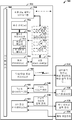
이제 도 9를 참조하면, 개시되어 있는 아키텍처에 따라 지오 태그형 아이템에 기초하여 지오 펜스의 생성을 실행하는 컴퓨팅 시스템(900)의 블록도가 도시되어 있다. 그러나, 개시되어 있는 방법 및/또는 시스템의 일부 또는 모든 측면은 아날로그, 디지털, 혼합 신호 및 다른 기능들이 단일 칩 기판 상에서 제조되는 시스템 온 칩으로서 구현될 수 있다. 이의 다양한 측면에 대한 추가적인 컨텍스트를 제공하기 위해, 도 9 및 후속하는 설명은 다양한 측면이 구현될 수 있는 적절한 컴퓨팅 시스템(900)의 간략하고, 일반적인 설명을 제공하려 한다. 전술한 설명은 하나 이상의 컴퓨터 상에서 실행될 수 있는 컴퓨터 실행가능 명령어들의 일반적인 문맥에서 설명되었지만, 당업자라면 신규한 실시예가 다른 프로그램 모듈과 연계하여 및/또는 하드웨어와 소프트웨어의 결합으로서 구현될 수 있음을 알 수 있을 것이다.Referring now to FIG. 9, a block diagram of a
다양한 측면을 구현하는 컴퓨팅 시스템(900)은 처리 장치(들)(904), 시스템 메모리(906)와 같은 컴퓨터 판독가능 저장소, 및 시스템 버스(908)를 구비한 컴퓨터(902)를 포함한다. 처리 장치(들)(904)는 싱글 프로세서, 멀티 프로세서, 싱글 코어 유닛 및 멀티 코어 유닛과 같은 임의의 다양한 상업적으로 입수가능한 프로세서일 수 있다. 또한, 당업자라면, 각각이 하나 이상의 관련 장치에 동작가능하게 연결될 수 있는 미니컴퓨터, 메인프레임 컴퓨터, 및 퍼스널 컴퓨터(예를 들어, 데스크탑, 랩탑 등), 핸드 헬드 컴퓨팅 장치, 마이크로프로세서 기반 또는 프로그램가능 소비자 전자장치 등을 포함하는 다른 컴퓨터 시스템 구성을 통해 신규한 방법이 실시될 수 있음을 알 수 있을 것이다.A
시스템 메모리(906)는 휘발성(VOL) 메모리(910)(예를 들어, 랜덤 액세스 메모리(RAM)) 및 비휘발성 메모리(NON-VOL)(912)(예를 들어, ROM, EPROM, EEPROM 등)와 같은 컴퓨터 판독가능 저장소(물리적 저장 매체)를 포함할 수 있다. 기본 입/출력 시스템(BIOS)은 비휘발성 메모리(912)에 저장될 수 있고, 시작 동안 컴퓨터(902) 내의 컴포넌트들 간의 데이터 및 신호의 통신을 용이하게 하는 기본 루틴을 포함할 수 있다. 휘발성 메모리(910)는 또한 데이터를 캐싱하는 정적 RAM과 같은 고속 RAM을 포함할 수 있다. System memory 906 includes volatile (VOL) memory 910 (e.g., random access memory RAM) and non-volatile memory (NON-VOL) 912 (e.g., ROM, EPROM, EEPROM, (Physical storage medium) such as a hard disk drive. The basic input / output system (BIOS) may be stored in
시스템 버스(908)는 시스템 컴포넌트들을 위한 인터페이스를 제공하는데, 예를 들어 시스템 메모리(906)와 처리 장치(들)(904) 간에 인터페이스를 포함하나, 여기에 국한되지는 않는다. 시스템 버스(908)는 임의의 다양한 상업적으로 입수가능한 버스 아키텍처를 사용하여, 메모리 버스(메모리 제어기를 구비하거나 또는 구비하지 않음), 및 주변 버스(예를 들어, PCI, PCIe, AGP, LPC 등)에 더 상호연결될 수 있는 임의의 몇몇 유형의 버스 구조일 수 있다.The
컴퓨터(902)는 머신 판독가능 저장 서브시스템(들)(914)과 이 저장 서브시스템(914)을 시스템 버스(908) 및 다른 원하는 컴퓨터 컴포넌트들에 인터페이싱시키는 저장 인터페이스(들)(916)를 더 포함한다. 저장 서브시스템(들)(914)(물리적 저장 매체)은 예를 들어 하드 디스크 드라이브(HDD), 자기 플로피 디스크 드라이브(FDD), 및/또는 광학 디스크 저장 드라이브(예를 들어, CD-ROM 드라이브, DVD 드라이브) 중 하나 이상을 포함할 수 있다. 저장 인터페이스(들)(916)는 예를 들어 EIDE, ATA, SATA 및 IEEE 1394와 같은 인터페이스 기술을 포함할 수 있다.The
운영 체제(920), 하나 이상의 애플리케이션 프로그램(922), 다른 프로그램 모듈(924) 및 프로그램 데이터(926)를 포함한 하나 이상의 프로그램 및 데이터는 메모리 서브시스템(906), 머신 판독가능 및 착탈가능 메모리 서브시스템(918)(예를 들어, 플래시 드라이브 폼 팩터 기술), 및/또는 저장 서브시스템(들)(914)(예를 들어, 광학, 자기, 고체 상태)에 저장될 수 있다.One or more programs and data, including an
운영 체제(920), 하나 이상의 애플리케이션 프로그램(922), 다른 프로그램 모듈(924) 및/또는 프로그램 데이터(926)는 도 1의 시스템(100)의 개체 및 컴포넌트들, 도 2의 시스템(200)의 개체 및 컴포넌트들, 도 3의 지오 태그형 아이템의 내장된 기능들, 도 4의 시스템(400)의 보안 측면, 및 도 5 내지 도 8의 흐름도로 표현된 방법들을 포함할 수 있다.
일반적으로, 프로그램은 특정 작업을 수행하거나 특정 추상 데이터 유형을 구현하는 루틴, 방법, 데이터 구조, 다른 소프트웨어 컴포넌트 등을 포함한다. 운영 체제(920), 애플리케이션(922), 모듈(924), 및/또는 데이터(926) 중 전부 또는 일부는 또한 예를 들어 휘발성 메모리(910)와 같은 메모리에 캐싱될 수 있다. 개시되어 있는 아키텍처는 다양한 상업적으로 입수가능한 운영 체제 또는 운영 체제들의 조합을 이용하여 (예를 들어, 가성 머신으로서) 구현될 수 있음을 알 수 있을 것이다.Generally, a program includes routines, methods, data structures, other software components, etc. that perform particular tasks or implement particular abstract data types. All or a portion of the
저장 서브시스템(들)(914) 및 메모리 서브시스템(906,918)은 데이터, 데이터 구조, 컴퓨터 실행가능 명령어들 등의 휘발성 및 비휘발성 저장을 위한 컴퓨터 판독가능 매체로서 역할을 한다. 이러한 명령어들은 컴퓨터 또는 다른 머신에 의해 실행되는 경우 컴퓨터 또는 머신으로 하여금 방법의 하나 이상의 동작을 수행하게 할 수 있다. 동작들을 수행하게 하는 명령어들은 하나의 매체 상에 저장될 수 있거나, 또는 다수의 매체에 걸쳐 저장될 수 있어 명령어들은 모든 명령어들이 동일한 매체 상에 있는지 여부와는 상관없이 하나 이상의 컴퓨터 판독가능 저장 매체 상에 통합적으로 나타나는 것으로 보인다. Storage subsystem (s) 914 and
컴퓨터 판독가능 매체는 컴퓨터(902)에 의해 액세스될 수 있는 임의의 이용가능 매체일 수 있고 착탈가능한 또는 착탈가능하지 않은 휘발성 및 비휘발성의 내부 및/또는 외부 매체를 포함할 수 있다. 컴퓨터(902)의 경우, 매체는 데이터의 저장을 임의의 적절한 디지털 포맷으로 수용한다. 당업자라면, 개시되어 있는 아키텍처의 신규한 방법을 수행하기 위한 컴퓨터 실행가능 명령어들을 저장하기 위해, 예를 들어 집(zip) 드라이브, 자기 테이프, 플래시 메모리 카드, 플래시 드라이브, 카트리지 등과 같은 다른 유형의 컴퓨터 판독가능 매체가 이용될 수 있음을 알 수 있을 것이다. Computer readable media can be any available media that can be accessed by
사용자는 키보드 및 마우스와 같은 외부 사용자 입력 장치(928)를 사용하여 컴퓨터(902), 프로그램 및 데이터와 상호작용할 수 있다. 다른 외부 사용자 입력 장치(928)는 마이크로폰, IR(적외선) 원격 제어, 조이스틱, 게임 패드, 카메라 인식 시스템, 스타일러스 펜, 터치 스크린, 제스처 시스템(예를 들어, 안구 이동, 머리 이동 등) 등을 포함할 수 있다. 사용자는 터치패드, 마이크로폰, 키보드 등과 같은 온보드 사용자 입력 장치(930)를 사용하여 컴퓨터(902), 프로그램 및 데이터와 상호작용할 수 있는데, 여기서 컴퓨터(902)는 예를 들어 휴대용 컴퓨터이다. 이들 및 다른 입력 장치는 시스템 버스(908)를 경유하여 입/출력(I/O) 장치 인터페이스(들)(932)를 통해 처리 장치(들)(904)에 연결되지만, 병렬 포트, IEEE 1394 직렬 포트, 게임 포트, USB 포트, IR 인터페이스, 단거리 무선(예를 들어, 블루투스) 및 다른 개인 영역 네트워크(PAN) 기술 등과 같은 다른 인터페이스에 의해서도 연결될 수 있다. I/O 장치 인터페이스(들)(932)는 또한 프린터, 오디오 장치, 카메라 장치, 사운드 카드 및/또는 온보드 오디오 처리 기능과 같은 출력 주변장치(934)의 사용을 용이하게 한다.The user may interact with the
하나 이상의 그래픽 인터페이스(들)(936)(일반적으로 그래픽 처리 장치(GPU)로도 지칭됨)는 컴퓨터(902)와 외부 디스플레이(들)(938)(예를 들어, LCD, 플라즈마) 및/또는 (예를 들어, 휴대용 컴퓨터용의) 온보드 디스플레이(940) 간에 그래픽 및 비디오 신호를 제공한다. 그래픽 인터페이스(들)(936)는 컴퓨터 시스템 보드의 일부로서 제조될 수 있다.One or more of the graphical interface (s) 936 (also commonly referred to as a graphics processing unit (GPU)) is coupled to the
컴퓨터(902)는 유선/무선 통신 서브시스템(942)을 경유하는 하나 이상의 네트워크 및/또는 다른 컴퓨터로의 논리적 연결들을 사용하여 (예를 들어, IP 기반의) 네트워크 환경에서 동작할 수 있다. 다른 컴퓨터는 워크스테이션, 서버, 라우터, 개인용 컴퓨터, 마이크로프로세서 기반 오락 기구, 피어 장치 또는 다른 공통 네트워크 노드를 포함할 수 있고, 전형적으로 컴퓨터(902)에 대해 설명한 다수의 또는 모든 요소들을 포함할 수 있다. 논리적 연결은 근거리 통신망(LAN), 광대역 통신망(WAN), 핫스팟 등에 대한 무선/유선 연결을 포함할 수 있다. LAN 및 WAN 네트워킹 환경은 사무실 및 회사에서 흔한 것이며 인트라넷과 같은 기업 전체 컴퓨터 네트워크를 용이하게 하며, 이들 모두는 인터넷과 같은 전역 통신 네트워크에 연결될 수 있다.The
네트워킹 환경에서 사용되는 경우, 컴퓨터(902)는 유선/무선 네트워크, 유선/무선 프린터, 유선/무선 입력 장치(944) 등과 통신하기 위해 유선/무선 통신 서브시스템(942)(예를 들어, 네트워크 인터페이스 어댑터, 온보드 트랜시버 서브시스템 등)을 통해 네트워크에 연결된다. 컴퓨터(902)는 네트워크를 통한 통신을 수립하기 위해 모뎀 또는 다른 수단을 포함할 수 있다. 네트워크 환경에서, 컴퓨터(902)에 관련된 프로그램 및 데이터는 분산형 시스템과 연관되는 것처럼, 원격 메모리/저장 장치에 저장될 수 있다. 도시되어 있는 네트워크 연결은 예시적이며 컴퓨터들 간의 통신 링크를 수립하기 위한 다른 수단이 사용될 수 있음을 알 수 있을 것이다.When used in a networking environment, the
컴퓨터(902)는 예를 들어 프린터, 스캐너, 데스크탑 및/또는 휴대용 컴퓨터, 개인 보조 단말기(PDA), 통신 위성, 무선으로 검출가능한 태그와 연관된 임의의 장비 하나 또는 위치(예를 들어, 키오스크, 뉴스스탠드, 화장실), 및 전화기와 무선 통신(예를 들어, IEEE 802.11 오버 디 에어 변조 기술)가능하게 배치된 무선 장치와 같이, IEEE 802.xx 표준 계열과 같은 무선 기술을 사용하는 유선/무선 장치 또는 개체와 통신하도록 동작가능하다. 이것은 적어도 핫스팟을 위한 (무선 컴퓨터 네트워킹 장치의 상호운용성을 증명하는데 사용되는) Wi-FiTM, WiMax 및 BluetoothTM 무선 기술을 포함한다. 따라서, 통신은 종래의 네트워크에서와 같이 사전정의된 구조일 수 있고 또는 간단히 적어도 두 개의 장치 간의 애드 혹 통신일 수 있다. Wi-Fi 네트워크는 IEEE 802.11x(a,b,g 등)으로 불리는 무선 기술을 사용하여 안전하고, 신뢰성 있으며, 빠른 무선 연결을 제공한다. Wi-Fi 네트워크는 컴퓨터들을 서로 연결하고, 인터넷에 연결하며 (IEEE 802.3 관련 매체 및 기능을 사용하는) 유선 네트워크에 연결하는데 사용될 수 있다.The
전술한 설명들은 개시되어 있는 아키텍처의 예를 포함한다. 물론, 컴포넌트들 및/또는 방법들의 모든 인지가능한 조합을 설명할 수는 없지만, 당업자라면 다수의 또 다른 조합 및 치환이 가능함을 알 수 있을 것이다. 따라서, 신규한 아키텍처는 첨부된 청구항의 사상 및 범주에 속하는 그러한 모든 대체, 변경 및 변형을 포함하려 한다. 또한, "포함한다(include)"라는 용어가 상세한 설명 또는 청구항에 사용되는 범위에 있어서, 이러한 용어는 "포함하는(comprising)"이라는 용어가 청구항에서 연결구로서 사용될 때 해석되는 바와 같이 이 "포함하는(comprising)" 용어와 유사한 방식으로 사용되려 한다.The foregoing description includes examples of the architectures disclosed. Of course, not all recognizable combinations of components and / or methods can be described, but one of ordinary skill in the art will recognize that many further combinations and permutations are possible. Accordingly, the novel architecture is intended to cover all such alternatives, modifications and variations that fall within the spirit and scope of the appended claims. Also, to the extent that the term "includes" is used in either the detailed description or the claims, such term is intended to be inclusive in a manner similar to the term " comprising " the term " comprising "
Claims (10)
상기 지오로케이션 정보에 기초한 상기 지리적 위치와 연계하여 가상 경계를 생성하는 경계 컴포넌트와,
상기 추출 컴포넌트 및 상기 경계 컴포넌트 중 적어도 하나와 연관된 컴퓨터 실행가능 명령어들을 실행하는 프로세서
를 포함하는 시스템.
An extraction component for extracting geolocation information of a geo-tagged item, the geolocation information being related to a geographical location at which the item is geotagged;
A boundary component for creating a virtual boundary in association with the geographic location based on the geolocation information;
A processor that executes computer executable instructions associated with at least one of the extraction component and the boundary component,
/ RTI >
상기 가상 경계는 사용자의 사용자 식별자와 연계되어 저장되는 시스템.
The method according to claim 1,
Wherein the virtual boundary is stored in association with a user identifier of the user.
상기 경계 컴포넌트는 상기 사용자의 위치 인식 장치에 의한 상기 가상 경계의 인게이지먼트(engagement)에 응답하여 상기 사용자와 연관된 액션을 개시하는 시스템.3. The method of claim 2,
Wherein the boundary component initiates an action associated with the user in response to engagement of the virtual boundary by the user's location recognition device.
상기 가상 경계는 상기 지오 태그형 아이템에 대한 액세스를 공유함으로써 또 다른 사용자와 공유되고, 상기 가상 경계는 상기 또 다른 사용자와 연관되는 시스템.
The method according to claim 1,
Wherein the virtual boundary is shared with another user by sharing access to the geotagged item, and wherein the virtual boundary is associated with the another user.
상기 지오 태그형 아이템은 내장된 액션 정보를 갖는 사진이며, 상기 내장된 액션 정보는 수신 사용자의 장치에 의해 처리되고, 상기 수신 사용자가 상기 가상 경계를 인게이지하는 것으로 검출되면 활성화되는 시스템.
The method according to claim 1,
Wherein the geotagged item is a picture with built-in action information, the embedded action information is processed by a device of the receiving user, and is activated when the receiving user is detected to be in the virtual boundary.
상기 위치 정보에 기초하여 상기 위치에 대한 지오 펜스를 생성하는 단계와,
메모리에 저장된 명령어들을 실행하는 프로세서를 이용하여 상기 추출하는 단계 및 상기 생성하는 단계 중 적어도 하나를 수행하는 단계
를 포함하는 방법.
Extracting positional information on the position from the geotagged medium;
Generating a geofence for the location based on the location information;
Performing at least one of the extracting and generating using a processor executing instructions stored in the memory
≪ / RTI >
연관된 사용자의 지오로케이션에 기초하여 상기 지오 펜스를 트리거하고 상기 지오 펜스가 트리거되는 경우 사용자에 대한 액션을 개시하는 단계를 더 포함하는 방법.
The method according to claim 6,
Triggering the geofence based on the geolocation of the associated user and initiating an action for the user if the geofence is triggered.
상기 지오 태그형 아이템을 또 다른 사용자와 공유함으로써 상기 또 다른 사용자에 대해 상기 지오 펜스를 생성하는 단계를 더 포함하는 방법.
The method according to claim 6,
And generating the geofence for the another user by sharing the geotagged item with another user.
상기 지오 펜스를 상기 위치 정보와 연관지어 저장하는 단계를 더 포함하는 방법.
The method according to claim 6,
And storing the geofence in association with the location information.
지오 태그형 사진의 위도-경도 데이터를 상기 지오 펜스를 생성하는데 사용되는 상기 위치 정보로서 추출하는 단계를 더 포함하는 방법.The method according to claim 6,
And extracting latitude-longitude data of the geotagged photograph as the location information used to generate the geofence.
Applications Claiming Priority (3)
| Application Number | Priority Date | Filing Date | Title |
|---|---|---|---|
| US13/293,095 | 2011-11-09 | ||
| US13/293,095 US20130117266A1 (en) | 2011-11-09 | 2011-11-09 | Geo-fence based on geo-tagged media |
| PCT/US2012/064004 WO2013070811A1 (en) | 2011-11-09 | 2012-11-08 | Geo-fence based on geo-tagged media |
Publications (1)
| Publication Number | Publication Date |
|---|---|
| KR20140089537A true KR20140089537A (en) | 2014-07-15 |
Family
ID=47644904
Family Applications (1)
| Application Number | Title | Priority Date | Filing Date |
|---|---|---|---|
| KR1020147012424A KR20140089537A (en) | 2011-11-09 | 2012-11-08 | Geo-fence based on geo-tagged media |
Country Status (6)
| Country | Link |
|---|---|
| US (1) | US20130117266A1 (en) |
| EP (1) | EP2776921A4 (en) |
| JP (1) | JP2014532951A (en) |
| KR (1) | KR20140089537A (en) |
| CN (1) | CN102930107A (en) |
| WO (1) | WO2013070811A1 (en) |
Cited By (3)
| Publication number | Priority date | Publication date | Assignee | Title |
|---|---|---|---|---|
| KR20190004301A (en) * | 2016-05-09 | 2019-01-11 | 힙웨어 인코포레이티드 | Geofences social media platform |
| KR20200125383A (en) * | 2019-04-25 | 2020-11-04 | 군산대학교산학협력단 | Method of Discovering Region of Attractions from Geo-tagged Photos and Apparatus Thereof |
| US11900394B1 (en) * | 2020-11-13 | 2024-02-13 | Gen Digital Inc. | Location-based anomaly detection based on geotagged digital photographs |
Families Citing this family (37)
| Publication number | Priority date | Publication date | Assignee | Title |
|---|---|---|---|---|
| US9549286B2 (en) * | 2013-02-22 | 2017-01-17 | Intel Corporation | Geo-fence notification management |
| US20140248912A1 (en) * | 2013-03-01 | 2014-09-04 | Barracuda Networks, Inc. | Systems and methods for sharing of geo-tagged file segments based on location of a mobile device |
| US9874452B2 (en) * | 2013-03-14 | 2018-01-23 | Ford Global Technologies, Llc | Method and apparatus for enhanced driving experience including dynamic POI identification |
| US20140365307A1 (en) * | 2013-06-07 | 2014-12-11 | Ebay Inc. | Transmitting listings based on detected location |
| US20150149542A1 (en) * | 2013-11-27 | 2015-05-28 | Chintan Jain | System and methods for generating and provisioning a personalized geo-fence |
| US10136251B2 (en) * | 2013-11-28 | 2018-11-20 | Microsoft Technology Licensing, Llc | Geofence compositions |
| US9307359B2 (en) * | 2013-12-05 | 2016-04-05 | Ebay Inc. | Methods, systems, and apparatus for a geo-fence system |
| US8938488B1 (en) * | 2013-12-27 | 2015-01-20 | Linkedin Corporation | Techniques for populating a content stream on a mobile device |
| WO2015123186A1 (en) * | 2014-02-11 | 2015-08-20 | Google Inc. | Virtual geographic perimeters made up of multiple component shapes |
| US9396354B1 (en) | 2014-05-28 | 2016-07-19 | Snapchat, Inc. | Apparatus and method for automated privacy protection in distributed images |
| CN104063423B (en) * | 2014-05-30 | 2017-11-21 | 小米科技有限责任公司 | A kind of method and device for determining position |
| US9113301B1 (en) | 2014-06-13 | 2015-08-18 | Snapchat, Inc. | Geo-location based event gallery |
| US10387457B2 (en) * | 2014-06-17 | 2019-08-20 | Sap Se | Grid-based analysis of geospatial trajectories |
| US10824654B2 (en) | 2014-09-18 | 2020-11-03 | Snap Inc. | Geolocation-based pictographs |
| US11216869B2 (en) | 2014-09-23 | 2022-01-04 | Snap Inc. | User interface to augment an image using geolocation |
| US9015285B1 (en) | 2014-11-12 | 2015-04-21 | Snapchat, Inc. | User interface for accessing media at a geographic location |
| US9385983B1 (en) | 2014-12-19 | 2016-07-05 | Snapchat, Inc. | Gallery of messages from individuals with a shared interest |
| US10311916B2 (en) | 2014-12-19 | 2019-06-04 | Snap Inc. | Gallery of videos set to an audio time line |
| US9413786B1 (en) | 2015-02-04 | 2016-08-09 | International Business Machines Corporation | Dynamic enterprise security control based on user risk factors |
| KR102163528B1 (en) | 2015-03-18 | 2020-10-08 | 스냅 인코포레이티드 | Geo-fence authorization provisioning |
| EP3152089A4 (en) | 2015-03-31 | 2017-08-02 | SZ DJI Technology Co., Ltd. | Systems and methods for geo-fencing device communications |
| JP6355034B2 (en) * | 2015-03-31 | 2018-07-11 | エスゼット ディージェイアイ テクノロジー カンパニー リミテッドSz Dji Technology Co.,Ltd | Geofencing device identification method and geofencing device identification system |
| CN113247254B (en) * | 2015-03-31 | 2023-03-17 | 深圳市大疆创新科技有限公司 | System and method for displaying geofence device information |
| CN107409051B (en) | 2015-03-31 | 2021-02-26 | 深圳市大疆创新科技有限公司 | Authentication system and method for generating flight controls |
| US10135949B1 (en) | 2015-05-05 | 2018-11-20 | Snap Inc. | Systems and methods for story and sub-story navigation |
| US10120948B2 (en) | 2015-10-13 | 2018-11-06 | Google Llc | Providing notifications based on geofencing search results |
| US9918191B2 (en) | 2015-10-26 | 2018-03-13 | Intel Corporation | Mobile geo-fence system |
| US10354425B2 (en) | 2015-12-18 | 2019-07-16 | Snap Inc. | Method and system for providing context relevant media augmentation |
| CN107291784B (en) * | 2016-04-13 | 2020-08-04 | 阿里巴巴集团控股有限公司 | Method and device for acquiring geo-fence categories and business equipment |
| US9589255B1 (en) | 2016-09-14 | 2017-03-07 | Graffiti Video Inc. | Collaborative media capture and sharing system |
| US10582277B2 (en) | 2017-03-27 | 2020-03-03 | Snap Inc. | Generating a stitched data stream |
| WO2018223346A1 (en) * | 2017-06-08 | 2018-12-13 | 深圳市乃斯网络科技有限公司 | Method and system for positioning in photograph sharing |
| CN108318902B (en) * | 2017-11-22 | 2021-02-05 | 和芯星通(上海)科技有限公司 | Self-adaptive geo-fence detection method and device, electronic equipment and management method |
| CN108389351A (en) * | 2018-04-24 | 2018-08-10 | 成都恒高科技有限公司 | Tag match, fence border control method, apparatus and storage medium |
| CN109819403B (en) * | 2019-01-28 | 2021-07-23 | 汉海信息技术(上海)有限公司 | Method and device for generating electronic fence and electronic equipment |
| CN110415012A (en) * | 2019-06-05 | 2019-11-05 | 中国联合网络通信集团有限公司 | Dynamic scene area determination method, device, equipment and readable storage medium storing program for executing |
| CN110602641A (en) * | 2019-09-17 | 2019-12-20 | 深圳市和讯华谷信息技术有限公司 | Wireless network pushing method and system based on geo-fencing |
Family Cites Families (15)
| Publication number | Priority date | Publication date | Assignee | Title |
|---|---|---|---|---|
| US6411899B2 (en) * | 1996-10-24 | 2002-06-25 | Trimble Navigation Ltd. | Position based personal digital assistant |
| JP2000181814A (en) * | 1998-12-14 | 2000-06-30 | Nec Corp | Electronic mail system |
| US7385499B2 (en) * | 2004-12-17 | 2008-06-10 | United Parcel Service Of America, Inc. | Item-based monitoring systems and methods |
| US7848765B2 (en) * | 2005-05-27 | 2010-12-07 | Where, Inc. | Location-based services |
| KR20100016169A (en) * | 2007-04-03 | 2010-02-12 | 휴먼 네트워크 랩스, 아이엔씨. | Method and apparatus for acquiring local position and overlaying information |
| EP2015024A3 (en) * | 2007-06-19 | 2009-03-25 | GroundSpeak, Inc. | System and method for providing player interfacing layouts for geolocational activities |
| US20090005071A1 (en) * | 2007-06-28 | 2009-01-01 | Apple Inc. | Event Triggered Content Presentation |
| US8797214B2 (en) * | 2007-07-06 | 2014-08-05 | Qualcomm Incorporated | Tracking implementing geopositioning and local modes |
| US8463297B2 (en) * | 2007-12-27 | 2013-06-11 | Trueposition, Inc. | Subscriber selective, area-based service control |
| US8170580B2 (en) * | 2008-11-04 | 2012-05-01 | International Business Machines Corporation | Geo-boundary triggered messaging and schedule system and method of use |
| US8018329B2 (en) * | 2008-12-12 | 2011-09-13 | Gordon * Howard Associates, Inc. | Automated geo-fence boundary configuration and activation |
| US8213957B2 (en) * | 2009-04-22 | 2012-07-03 | Trueposition, Inc. | Network autonomous wireless location system |
| US8577590B2 (en) * | 2009-11-09 | 2013-11-05 | Qualcomm Incorporated | Scalable geofences |
| US8284748B2 (en) * | 2010-07-07 | 2012-10-09 | Apple Inc. | Ad hoc formation and tracking of location-sharing groups |
| US20120324018A1 (en) * | 2011-06-16 | 2012-12-20 | Yahoo! Inc. | Systems and methods for location based social network |
-
2011
- 2011-11-09 US US13/293,095 patent/US20130117266A1/en not_active Abandoned
-
2012
- 2012-11-08 EP EP12847017.6A patent/EP2776921A4/en not_active Withdrawn
- 2012-11-08 WO PCT/US2012/064004 patent/WO2013070811A1/en active Application Filing
- 2012-11-08 JP JP2014541209A patent/JP2014532951A/en not_active Ceased
- 2012-11-08 KR KR1020147012424A patent/KR20140089537A/en not_active Application Discontinuation
- 2012-11-09 CN CN2012104460946A patent/CN102930107A/en active Pending
Cited By (5)
| Publication number | Priority date | Publication date | Assignee | Title |
|---|---|---|---|---|
| KR20190004301A (en) * | 2016-05-09 | 2019-01-11 | 힙웨어 인코포레이티드 | Geofences social media platform |
| US10694323B2 (en) | 2016-05-09 | 2020-06-23 | Hippware, Inc. | Platform for geo-fence social media |
| KR20200125383A (en) * | 2019-04-25 | 2020-11-04 | 군산대학교산학협력단 | Method of Discovering Region of Attractions from Geo-tagged Photos and Apparatus Thereof |
| KR20210004918A (en) * | 2019-04-25 | 2021-01-13 | 군산대학교산학협력단 | Method of Discovering Region of Attractions from Geo-tagged Photos and Apparatus Thereof |
| US11900394B1 (en) * | 2020-11-13 | 2024-02-13 | Gen Digital Inc. | Location-based anomaly detection based on geotagged digital photographs |
Also Published As
| Publication number | Publication date |
|---|---|
| CN102930107A (en) | 2013-02-13 |
| US20130117266A1 (en) | 2013-05-09 |
| EP2776921A4 (en) | 2016-04-13 |
| JP2014532951A (en) | 2014-12-08 |
| EP2776921A1 (en) | 2014-09-17 |
| WO2013070811A1 (en) | 2013-05-16 |
Similar Documents
| Publication | Publication Date | Title |
|---|---|---|
| KR20140089537A (en) | Geo-fence based on geo-tagged media | |
| JP5813863B2 (en) | Private and public applications | |
| US8365243B1 (en) | Image leak prevention using geotagging | |
| US8423511B1 (en) | Systems and methods for securing data on mobile devices | |
| EP2708045B1 (en) | Presenting messages associated with locations | |
| AU2012202777B2 (en) | Retrieving contact information based on image recognition searches | |
| EP3320477B1 (en) | Protecting data from unauthorized access | |
| US8864019B2 (en) | Auto configurable transfer and management system | |
| JP2014519103A (en) | Find nearby places based on automatic queries | |
| US20150230078A1 (en) | Secure Ad Hoc Data Backup to Nearby Friend Devices | |
| KR102364709B1 (en) | Method and apparatus for mobile-based cartographic control of display content | |
| CN117678196A (en) | Privacy security joint identification protocol | |
| US20230403323A1 (en) | Domain replication across regions | |
| US8918471B2 (en) | Integrated local/remote server computer architecture for electronic data transfer | |
| US20220394092A1 (en) | Proximity Routing Policy Enforcement for Trans-Border Internet of Things Data Governance Compliance | |
| US11374746B2 (en) | Time-aware blockchain staged regulatory control of internet of things data | |
| US9591553B1 (en) | Content access based on mobile device geographical location | |
| US20240144359A1 (en) | Providing and Using a Digital Asset Delivery Service | |
| US20240106652A1 (en) | Providing and Using a User Login Protection Service | |
| KR102087207B1 (en) | Method and apparatus for location based document security | |
| WO2019037635A1 (en) | Method for changing group type and group creation method and device | |
| JP2015119337A (en) | Information processing device, information processing method, and program |
Legal Events
| Date | Code | Title | Description |
|---|---|---|---|
| N231 | Notification of change of applicant | ||
| WITN | Application deemed withdrawn, e.g. because no request for examination was filed or no examination fee was paid |