US9874452B2 - Method and apparatus for enhanced driving experience including dynamic POI identification - Google Patents
Method and apparatus for enhanced driving experience including dynamic POI identification Download PDFInfo
- Publication number
- US9874452B2 US9874452B2 US13/826,022 US201313826022A US9874452B2 US 9874452 B2 US9874452 B2 US 9874452B2 US 201313826022 A US201313826022 A US 201313826022A US 9874452 B2 US9874452 B2 US 9874452B2
- Authority
- US
- United States
- Prior art keywords
- geo
- fence
- coordinates
- poi
- coordinate
- Prior art date
- Legal status (The legal status is an assumption and is not a legal conclusion. Google has not performed a legal analysis and makes no representation as to the accuracy of the status listed.)
- Active, expires
Links
Images


Classifications
-
- G—PHYSICS
- G01—MEASURING; TESTING
- G01C—MEASURING DISTANCES, LEVELS OR BEARINGS; SURVEYING; NAVIGATION; GYROSCOPIC INSTRUMENTS; PHOTOGRAMMETRY OR VIDEOGRAMMETRY
- G01C21/00—Navigation; Navigational instruments not provided for in groups G01C1/00 - G01C19/00
- G01C21/26—Navigation; Navigational instruments not provided for in groups G01C1/00 - G01C19/00 specially adapted for navigation in a road network
- G01C21/34—Route searching; Route guidance
- G01C21/3453—Special cost functions, i.e. other than distance or default speed limit of road segments
- G01C21/3476—Special cost functions, i.e. other than distance or default speed limit of road segments using point of interest [POI] information, e.g. a route passing visible POIs
-
- G—PHYSICS
- G01—MEASURING; TESTING
- G01C—MEASURING DISTANCES, LEVELS OR BEARINGS; SURVEYING; NAVIGATION; GYROSCOPIC INSTRUMENTS; PHOTOGRAMMETRY OR VIDEOGRAMMETRY
- G01C21/00—Navigation; Navigational instruments not provided for in groups G01C1/00 - G01C19/00
- G01C21/26—Navigation; Navigational instruments not provided for in groups G01C1/00 - G01C19/00 specially adapted for navigation in a road network
- G01C21/34—Route searching; Route guidance
- G01C21/36—Input/output arrangements for on-board computers
- G01C21/3679—Retrieval, searching and output of POI information, e.g. hotels, restaurants, shops, filling stations, parking facilities
Definitions
- the illustrative embodiments generally relate to a method and apparatus for enhanced driving experience including dynamic point of interest (POI) identification.
- POI point of interest
- U.S. Pat. No. 8,290,704 generally relates to a system and method for collecting and conveying point of interest (POI) information is disclosed.
- the system detects when a vehicle is at a previously unknown POI, gathers information related to the new POI, and updates a central server with the new POI location information.
- a POI may be any type of location including roads, gas stations, strip malls, retail establishments, eating establishments, hospitals, police stations, etc.
- POI information may include a variety of data including new road locations, new entrances to roads, toll amounts, gas station names, gas prices, strip mall names, retail establishment names, eating establishment names, sales and specials, hospital names, emergency room entrance locations, police station entrances, etc.
- U.S. Application Publication 2007/0219706 generally relates to methods, apparatus, and systems for determining the relevance of points of interest for a user are described.
- An application server receives information about a user's location, and velocity, as well as other user preferences, and adjusts a search space and filters points of interest identifying those that are relevant to the user. The relevance of the points of interest are based on the user's route, location and velocity.
- U.S. Pat. No. 7,286,931 generally relates to a vehicle navigation device provided for permitting the display of the current POI (Point of Interest) information about points of interest which serve as landmarks near a guidance route to the destination, thereby improving visibility when a user identifies the guidance route.
- a vehicle navigation device is connected in communication with a provider for offering transmission service of map information which includes the current POI information pertaining to locations on a map where the points of interest are located.
- the navigation device includes a display unit, information input means, communications means, and control means.
- the control means accesses the provider through the communications means when the guidance route to the destination is set by the information input means, to obtain the current POI information about an area near the set guidance route from the map information, so that the obtained current POI information is displayed on a screen of the display unit, together with the guidance route and a vehicle position mark for designating a present position of a vehicle.
- a system in a first illustrative embodiment, includes a processor configured to receive vehicle coordinates.
- the processor is also configured to compare the vehicle coordinates to geo-fence coordinate sets of a plurality of geo-fences surrounding point of interest (POI), wherein at least a portion of each geo-fence is within some predetermined distance from the vehicle coordinates.
- the processor is further configured to receive information relating to the POI if the vehicle coordinates fall within the geo-fence coordinates and instruct presentation of the received information to vehicle occupants.
- POI point of interest
- a computer-implemented includes receiving vehicle coordinates.
- the method also includes comparing the vehicle coordinates, via a computing system, to geo-fence coordinate sets of a plurality of geo-fences surrounding point of interest (POI), wherein at least a portion of each geo-fence is within some predetermined distance from the vehicle coordinates.
- the method further includes receiving information relating to the POI if the vehicle coordinates fall within the geo-fence coordinates and instructing presentation of the received information to vehicle occupants.
- POI point of interest
- a non-transitory, computer readable storage medium stores instructions that, when executed by a processor, cause the processor to perform a method including receiving vehicle coordinates.
- the method also includes comparing the vehicle coordinates, via a computing system, to geo-fence coordinate sets of a plurality of geo-fences surrounding point of interest (POI), wherein at least a portion of each geo-fence is within some predetermined distance from the vehicle coordinates.
- the method further includes receiving information relating to the POI if the vehicle coordinates fall within the geo-fence coordinates and instructing presentation of the received information to vehicle occupants.
- POI point of interest
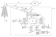
- FIG. 1 shows an illustrative vehicle computing system
- FIGS. 2A and 2B show an illustrative example of a point of interest (POI) determination and provision process
- FIG. 3 shows an illustrative example of a POI pre-loading process
- FIG. 4A shows an illustrative example of another pre-loading process
- FIG. 4B shows an illustrative example of a POI recognition process
- FIG. 5 shows an illustrative example of a POI playback process.
- FIG. 1 illustrates an example block topology for a vehicle based computing system 1 (VCS) for a vehicle 31 .
- VCS vehicle based computing system 1
- An example of such a vehicle-based computing system 1 is the SYNC system manufactured by THE FORD MOTOR COMPANY.
- a vehicle enabled with a vehicle-based computing system may contain a visual front end interface 4 located in the vehicle. The user may also be able to interact with the interface if it is provided, for example, with a touch sensitive screen. In another illustrative embodiment, the interaction occurs through, button presses, audible speech and speech synthesis.
- a processor 3 controls at least some portion of the operation of the vehicle-based computing system.
- the processor allows onboard processing of commands and routines.
- the processor is connected to both non-persistent 5 and persistent storage 7 .
- the non-persistent storage is random access memory (RAM) and the persistent storage is a hard disk drive (HDD) or flash memory.
- the processor is also provided with a number of different inputs allowing the user to interface with the processor.
- a microphone 29 an auxiliary input 25 (for input 33 ), a USB input 23 , a GPS input 24 and a BLUETOOTH input 15 are all provided.
- An input selector 51 is also provided, to allow a user to swap between various inputs. Input to both the microphone and the auxiliary connector is converted from analog to digital by a converter 27 before being passed to the processor.
- numerous of the vehicle components and auxiliary components in communication with the VCS may use a vehicle network (such as, but not limited to, a CAN bus) to pass data to and from the VCS (or components thereof).
- Outputs to the system can include, but are not limited to, a visual display 4 and a speaker 13 or stereo system output.
- the speaker is connected to an amplifier 11 and receives its signal from the processor 3 through a digital-to-analog converter 9 .
- Output can also be made to a remote BLUETOOTH device such as PND 54 or a USB device such as vehicle navigation device 60 along the bi-directional data streams shown at 19 and 21 respectively.
- the system 1 uses the BLUETOOTH transceiver 15 to communicate 17 with a user's nomadic device 53 (e.g., cell phone, smart phone, PDA, or any other device having wireless remote network connectivity).
- the nomadic device can then be used to communicate 59 with a network 61 outside the vehicle 31 through, for example, communication 55 with a cellular tower 57 .
- tower 57 may be a WiFi access point.
- Exemplary communication between the nomadic device and the BLUETOOTH transceiver is represented by signal 14 .
- Pairing a nomadic device 53 and the BLUETOOTH transceiver 15 can be instructed through a button 52 or similar input. Accordingly, the CPU is instructed that the onboard BLUETOOTH transceiver will be paired with a BLUETOOTH transceiver in a nomadic device.
- Data may be communicated between CPU 3 and network 61 utilizing, for example, a data-plan, data over voice, or DTMF tones associated with nomadic device 53 .
- the nomadic device 53 can then be used to communicate 59 with a network 61 outside the vehicle 31 through, for example, communication 55 with a cellular tower 57 .
- the modem 63 may establish communication 20 with the tower 57 for communicating with network 61 .
- modem 63 may be a USB cellular modem and communication 20 may be cellular communication.
- the processor is provided with an operating system including an API to communicate with modem application software.
- the modem application software may access an embedded module or firmware on the BLUETOOTH transceiver to complete wireless communication with a remote BLUETOOTH transceiver (such as that found in a nomadic device).
- Bluetooth is a subset of the IEEE 802 PAN (personal area network) protocols.
- IEEE 802 LAN (local area network) protocols include WiFi and have considerable cross-functionality with IEEE 802 PAN. Both are suitable for wireless communication within a vehicle.
- Another communication means that can be used in this realm is free-space optical communication (such as IrDA) and non-standardized consumer IR protocols.
- nomadic device 53 includes a modem for voice band or broadband data communication.
- a technique known as frequency division multiplexing may be implemented when the owner of the nomadic device can talk over the device while data is being transferred. At other times, when the owner is not using the device, the data transfer can use the whole bandwidth (300 Hz to 3.4 kHz in one example). While frequency division multiplexing may be common for analog cellular communication between the vehicle and the internet, and is still used, it has been largely replaced by hybrids of with Code Domian Multiple Access (CDMA), Time Domain Multiple Access (TDMA), Space-Domian Multiple Access (SDMA) for digital cellular communication.
- CDMA Code Domian Multiple Access
- TDMA Time Domain Multiple Access
- SDMA Space-Domian Multiple Access
- ITU IMT-2000 (3G) compliant standards offer data rates up to 2 mbs for stationary or walking users and 385 kbs for users in a moving vehicle.
- 3G standards are now being replaced by IMT-Advanced (4G) which offers 100 mbs for users in a vehicle and 1 gbs for stationary users.
- 4G IMT-Advanced
- nomadic device 53 is replaced with a cellular communication device (not shown) that is installed to vehicle 31 .
- the ND 53 may be a wireless local area network (LAN) device capable of communication over, for example (and without limitation), an 802.11g network (i.e., WiFi) or a WiMax network.
- LAN wireless local area network
- incoming data can be passed through the nomadic device via a data-over-voice or data-plan, through the onboard BLUETOOTH transceiver and into the vehicle's internal processor 3 .
- the data can be stored on the HDD or other storage media 7 until such time as the data is no longer needed.
- USB is one of a class of serial networking protocols.
- IEEE 1394 firewire
- EIA Electronics Industry Association
- IEEE 1284 Chipperability for Microwave Access
- S/PDIF Synchronization/Philips Digital Interconnect Format
- USB-IF USB Implementers Forum
- auxiliary device 65 may include, but are not limited to, personal media players, wireless health devices, portable computers, and the like.
- the CPU could be connected to a vehicle based wireless router 73 , using for example a WiFi 71 transceiver. This could allow the CPU to connect to remote networks in range of the local router 73 .
- the exemplary processes may be executed by a computing system in communication with a vehicle computing system.
- a computing system may include, but is not limited to, a wireless device (e.g., and without limitation, a mobile phone) or a remote computing system (e.g., and without limitation, a server) connected through the wireless device.
- a wireless device e.g., and without limitation, a mobile phone
- a remote computing system e.g., and without limitation, a server
- VACS vehicle associated computing systems
- particular components of the VACS may perform particular portions of a process depending on the particular implementation of the system.
- VACS vehicle computing system
- the illustrative embodiments provide an opportunity to identify relevant points of interest as a vehicle travels pass those points.
- the points can be traditional points of interest, or they can be added to a POI server with respect to a special event. In other words, they can have a temporal aspect added thereto. If a system contains or accesses such points of interest, the time at which the access is made may also be considered. If the time is past an “end time” or “end date,” the POI may be ignored. In another example, the POI may also be removed from the database once it has expired.
- customers may be able to request downloads of new POIs at any point along a journey.
- Customers can enter a route and ask the vehicle which POIs will be “encountered” (as according to the illustrative embodiments, for example) along a route. Since the vehicle or cloud server can estimate arrival times based on known travel data, the vehicle could also attempt to “guess” at which time a vehicle will pass through POIs. This can be useful if the POIs are temporary.
- FIGS. 2A and 2B show an illustrative example of a point of interest (POI) determination and provision process.
- customer information 203 is sent 201 to a remote server 205 for POI processing.
- This information can identify a customer's vehicle, route, location, subscriptions, eligibilities, etc.
- the information 207 can also be signed and encrypted 209 for further processing, so that the customer's location and personal information are secure.
- POIs have geo-fences associated therewith.
- these geo-fences can be expanded, so that a driver may not need to be in the immediate vicinity.
- a building of nominal size, a park, etc. these geo-fences may be smaller, such that they are only tripped by a vehicle passing in immediate proximity to the POI.
- suitable changes can be made as a provider sees fit.
- POI information 207 and/or geo-fence information 211 can be compared to current customer information on a remote server to determine if any criteria for pre-loading POI information to a vehicle are met. For example, if a route has been delivered to the remote server, the process can compare the route to possible POIs and geo-fences for determination of suitable pre-loading of POI information relating to the route.
- POI and geo-fence information relating to the POIs is uploaded 213 , 215 to a remote server.
- the information about POIs 217 and geo-fences 219 is shared with an in-vehicle system as well.
- the POI information is send 221 and the geo-fence information is sent 223 so that a local vehicle processor can determine if there is any coincidence between a present vehicle location and a POI.
- a validation and notice is received 225 when a POI is engaged in the vehicle. Notification about this notice 227 is sent to a remote server 229 for processing.
- the notification 231 can be sent to metrics processing 233 to see how frequently certain POI information is being used. This can help refine the POI database.
- FIG. 2B shows another portion of the overall exemplary system, seen from the perspective of a mobile device and VCS.
- the VCS has the POI provision feature enabled 263 .
- the system uses GPS or other coordinates 261 to compare a vehicle position 259 to geo-fences of various POIS 257 .
- the process could receive a number of bounded areas, and if a GPS coordinate of the vehicle fell within one of these bounded areas, the process would trigger and “in geo-fence” tag 249 .
- the geo-fence coordinates themselves can be received 255 from the remote server, which sends the coordinates 243 relating to various geo-fenced objects.
- the server also sends POI information 241 relating to various points of interest along a route, in a given area, etc.
- the VCS recognizes that a vehicle is within a geo-fence, denoted by the geo-fence tag, the VCS can pull the POI information 247 .
- This information 251 is then passed along to a playback function, where the VCS can play or otherwise present the POI information 253 for the user's perusal.
- the notification that a vehicle is within a geo-fence 245 can also be sent back to the monitoring server, so that general usage of various geo-fences can be tracked.
- the tracking function may be enabled on a mobile device 281 .
- the process can track the coordinates of the mobile device itself (which is either in the vehicle or in the possession of a walking person, for example).
- the coordinates of the device are compared 277 to the Geo-fence coordinates provided by the remote server to determine if the device is within the geo-fence 267 .
- the mobile device receives the geo-fence coordinates 273 from the remote server and passes the coordinates 275 to the comparison function.
- the mobile device can pull the POI information 265 and pass the POI information 269 to a process for viewing/displaying/presenting 271 the POI information. In this manner, users can take advantage of the system while walking, and/or can use the system even if a vehicle is not equipped with all the proper technology to provide the experience on-board.
- FIG. 3 shows an illustrative example of a POI pre-loading process. Since many POIs along a route may be passed quickly, and may have smaller geo-fences associated with them, it may be useful to pre-load the geo-fences and/or POI information for various features projected to be along a route. Then, at least with respect to these coordinates, the process has the information needed at the time the fence is breached, so that the information can be quickly presented. Even a deviation from a route can be compensated for, as the process would then only need to pull the coordinates related to a re-route.
- a remote server or an on-board or on-phone process may receive a route to be traveled 301 . Based on this route, a series of coordinate locations along the route can be established 303 . For each or some subset of coordinates, the process can compare the coordinates to various geo-fences known to be in the area of the coordinate 305 . If there is a match (i.e., the coordinates are within the fence), the process can download POI data.
- the download can consist of sending the information to a local device (vehicle/phone). If the process is running on a local device, the download can consist of requesting the information from the remote server.
- the process can then continue with additional coordinate points 309 until all coordinate points have been examined 313 . Once all coordinate points have been examined for a projected route (which could include some standard of deviation if desired), the process can being tracking the vehicle location 315 to determine if the vehicle actually encounters a geo-fence.
- FIG. 4A shows an illustrative example of another pre-loading process.
- the process receives a route 401 based on an input destination.
- a deviation from a route is considered, which can consist of establishing a bounded perimeter about the route 403 .
- the perimeter need not be uniform in deviance, but can be set according to appropriate desires.
- various geo-fences in the region of the route can then be compared for points of coincidence 405 .
- a subset can be created, which represents geo-fences that “may” come in contact with a vehicle along a trip. If this set is small enough, or if it is appropriate, this subset of POIs may be downloaded as well as those for which the route is projected to interject.
- FIG. 4B shows an illustrative example of a POI recognition process.
- the server receives GPS coordinates of a vehicle 401 . It is possible to “cloud track” the vehicle, which is, the server will determine if a POI delivery should be made. It is also possible to track the vehicle locally for comparison to the geo-fences of various POIs. In this example, some number of POIs have already been pre-sent to a vehicle.
- the process determines if cloud-tracking is enabled 403 . If the vehicle will be tracked locally at the vehicle (which is to say, if the comparison will be done locally), then a perimeter can be established around the GPS coordinates for comparison purposes 411 . This can help pick up geo-fences that are not exactly in the vicinity of a vehicle. Of course, larger geo-fences could also serve the same purposes. Also, in this example, since the vehicle is making the comparison, the server could provide a slightly larger (or some) perimeter, such that the projected coordinates may fall within the fence before the actual coordinates do (providing extra time for data transfer).
- the process will then check to see if information about the fence and POI have been previously transmitted 415 . If this information has not been previously transmitted, the fence and POI information will be sent to the vehicle 417 .
- the process compares the current coordinates to the fences of various objects 405 . If there is a match (i.e., the vehicle is proximate to an object) 407 , the process can send the POI data relating to the proximate object 409 .
- the comparison engine could lay a circle, square or other shape on a map having geo-fences provided thereto.
- the shape could be centered about a coordinate point.
- each of the geo-fences falling within the shape could be considered a possible POI that could be encountered.
- Other suitable considerations could also be used, including, but not limited to distance of a center of a fence, the POI or some portion of the fence from a current route.
- FIG. 5 shows an illustrative example of a POI playback process.
- the process receives a POI request for information 501 .
- This corresponds to information about a particular POI, and can include the playback capabilities of various devices. If the request comes from a vehicle 503 , the process will send the playback information to the vehicle 505 .
- This information can be set to specifically playback on a vehicle, and may differ from mobile information.
- the process can send the information back to the mobile device 509 .
- the information may be uniquely suited to mobile device playback, if desired. This can continue for any additional devices which may request the POI information.
Abstract
A system includes a processor configured to receive vehicle coordinates. The processor is also configured to compare the vehicle coordinates to geo-fence coordinate sets of a plurality of geo-fences surrounding point of interest (POI), wherein at least a portion of each geo-fence is within some predetermined distance from the vehicle coordinates. The processor is further configured to receive information relating to the POI if the vehicle coordinates fall within the geo-fence coordinates and instruct presentation of the received information to vehicle occupants.
Description
The illustrative embodiments generally relate to a method and apparatus for enhanced driving experience including dynamic point of interest (POI) identification.
Many vehicles now sold are provided with complex and powerful computing and communication systems provided thereto. Often including navigation, user interactivity and a variety of possible features, these systems can enhance and improve the driving experience. Through connections to cloud based processors and the wealth of information provided on the Internet and remote servers, these systems can draw on numerous remote resources to further upgrade the driving experience.
U.S. Pat. No. 8,290,704 generally relates to a system and method for collecting and conveying point of interest (POI) information is disclosed. The system detects when a vehicle is at a previously unknown POI, gathers information related to the new POI, and updates a central server with the new POI location information. In this context, a POI may be any type of location including roads, gas stations, strip malls, retail establishments, eating establishments, hospitals, police stations, etc. POI information may include a variety of data including new road locations, new entrances to roads, toll amounts, gas station names, gas prices, strip mall names, retail establishment names, eating establishment names, sales and specials, hospital names, emergency room entrance locations, police station entrances, etc.
U.S. Application Publication 2007/0219706 generally relates to methods, apparatus, and systems for determining the relevance of points of interest for a user are described. An application server receives information about a user's location, and velocity, as well as other user preferences, and adjusts a search space and filters points of interest identifying those that are relevant to the user. The relevance of the points of interest are based on the user's route, location and velocity.
U.S. Pat. No. 7,286,931 generally relates to a vehicle navigation device provided for permitting the display of the current POI (Point of Interest) information about points of interest which serve as landmarks near a guidance route to the destination, thereby improving visibility when a user identifies the guidance route. A vehicle navigation device is connected in communication with a provider for offering transmission service of map information which includes the current POI information pertaining to locations on a map where the points of interest are located. The navigation device includes a display unit, information input means, communications means, and control means. The control means accesses the provider through the communications means when the guidance route to the destination is set by the information input means, to obtain the current POI information about an area near the set guidance route from the map information, so that the obtained current POI information is displayed on a screen of the display unit, together with the guidance route and a vehicle position mark for designating a present position of a vehicle.
In a first illustrative embodiment, a system includes a processor configured to receive vehicle coordinates. The processor is also configured to compare the vehicle coordinates to geo-fence coordinate sets of a plurality of geo-fences surrounding point of interest (POI), wherein at least a portion of each geo-fence is within some predetermined distance from the vehicle coordinates. The processor is further configured to receive information relating to the POI if the vehicle coordinates fall within the geo-fence coordinates and instruct presentation of the received information to vehicle occupants.
In a second illustrative embodiment, a computer-implemented includes receiving vehicle coordinates. The method also includes comparing the vehicle coordinates, via a computing system, to geo-fence coordinate sets of a plurality of geo-fences surrounding point of interest (POI), wherein at least a portion of each geo-fence is within some predetermined distance from the vehicle coordinates. The method further includes receiving information relating to the POI if the vehicle coordinates fall within the geo-fence coordinates and instructing presentation of the received information to vehicle occupants.
In a third illustrative embodiment, a non-transitory, computer readable storage medium, stores instructions that, when executed by a processor, cause the processor to perform a method including receiving vehicle coordinates. The method also includes comparing the vehicle coordinates, via a computing system, to geo-fence coordinate sets of a plurality of geo-fences surrounding point of interest (POI), wherein at least a portion of each geo-fence is within some predetermined distance from the vehicle coordinates. The method further includes receiving information relating to the POI if the vehicle coordinates fall within the geo-fence coordinates and instructing presentation of the received information to vehicle occupants.
As required, detailed embodiments of the present invention are disclosed herein; however, it is to be understood that the disclosed embodiments are merely exemplary of the invention that may be embodied in various and alternative forms. The figures are not necessarily to scale; some features may be exaggerated or minimized to show details of particular components. Therefore, specific structural and functional details disclosed herein are not to be interpreted as limiting, but merely as a representative basis for teaching one skilled in the art to variously employ the present invention.
In the illustrative embodiment 1 shown in FIG. 1 , a processor 3 controls at least some portion of the operation of the vehicle-based computing system. Provided within the vehicle, the processor allows onboard processing of commands and routines. Further, the processor is connected to both non-persistent 5 and persistent storage 7. In this illustrative embodiment, the non-persistent storage is random access memory (RAM) and the persistent storage is a hard disk drive (HDD) or flash memory.
The processor is also provided with a number of different inputs allowing the user to interface with the processor. In this illustrative embodiment, a microphone 29, an auxiliary input 25 (for input 33), a USB input 23, a GPS input 24 and a BLUETOOTH input 15 are all provided. An input selector 51 is also provided, to allow a user to swap between various inputs. Input to both the microphone and the auxiliary connector is converted from analog to digital by a converter 27 before being passed to the processor. Although not shown, numerous of the vehicle components and auxiliary components in communication with the VCS may use a vehicle network (such as, but not limited to, a CAN bus) to pass data to and from the VCS (or components thereof).
Outputs to the system can include, but are not limited to, a visual display 4 and a speaker 13 or stereo system output. The speaker is connected to an amplifier 11 and receives its signal from the processor 3 through a digital-to-analog converter 9. Output can also be made to a remote BLUETOOTH device such as PND 54 or a USB device such as vehicle navigation device 60 along the bi-directional data streams shown at 19 and 21 respectively.
In one illustrative embodiment, the system 1 uses the BLUETOOTH transceiver 15 to communicate 17 with a user's nomadic device 53 (e.g., cell phone, smart phone, PDA, or any other device having wireless remote network connectivity). The nomadic device can then be used to communicate 59 with a network 61 outside the vehicle 31 through, for example, communication 55 with a cellular tower 57. In some embodiments, tower 57 may be a WiFi access point.
Exemplary communication between the nomadic device and the BLUETOOTH transceiver is represented by signal 14.
Pairing a nomadic device 53 and the BLUETOOTH transceiver 15 can be instructed through a button 52 or similar input. Accordingly, the CPU is instructed that the onboard BLUETOOTH transceiver will be paired with a BLUETOOTH transceiver in a nomadic device.
Data may be communicated between CPU 3 and network 61 utilizing, for example, a data-plan, data over voice, or DTMF tones associated with nomadic device 53. Alternatively, it may be desirable to include an onboard modem 63 having antenna 18 in order to communicate 16 data between CPU 3 and network 61 over the voice band. The nomadic device 53 can then be used to communicate 59 with a network 61 outside the vehicle 31 through, for example, communication 55 with a cellular tower 57. In some embodiments, the modem 63 may establish communication 20 with the tower 57 for communicating with network 61. As a non-limiting example, modem 63 may be a USB cellular modem and communication 20 may be cellular communication.
In one illustrative embodiment, the processor is provided with an operating system including an API to communicate with modem application software. The modem application software may access an embedded module or firmware on the BLUETOOTH transceiver to complete wireless communication with a remote BLUETOOTH transceiver (such as that found in a nomadic device). Bluetooth is a subset of the IEEE 802 PAN (personal area network) protocols. IEEE 802 LAN (local area network) protocols include WiFi and have considerable cross-functionality with IEEE 802 PAN. Both are suitable for wireless communication within a vehicle. Another communication means that can be used in this realm is free-space optical communication (such as IrDA) and non-standardized consumer IR protocols.
In another embodiment, nomadic device 53 includes a modem for voice band or broadband data communication. In the data-over-voice embodiment, a technique known as frequency division multiplexing may be implemented when the owner of the nomadic device can talk over the device while data is being transferred. At other times, when the owner is not using the device, the data transfer can use the whole bandwidth (300 Hz to 3.4 kHz in one example). While frequency division multiplexing may be common for analog cellular communication between the vehicle and the internet, and is still used, it has been largely replaced by hybrids of with Code Domian Multiple Access (CDMA), Time Domain Multiple Access (TDMA), Space-Domian Multiple Access (SDMA) for digital cellular communication. These are all ITU IMT-2000 (3G) compliant standards and offer data rates up to 2 mbs for stationary or walking users and 385 kbs for users in a moving vehicle. 3G standards are now being replaced by IMT-Advanced (4G) which offers 100 mbs for users in a vehicle and 1 gbs for stationary users. If the user has a data-plan associated with the nomadic device, it is possible that the data-plan allows for broad-band transmission and the system could use a much wider bandwidth (speeding up data transfer). In still another embodiment, nomadic device 53 is replaced with a cellular communication device (not shown) that is installed to vehicle 31. In yet another embodiment, the ND 53 may be a wireless local area network (LAN) device capable of communication over, for example (and without limitation), an 802.11g network (i.e., WiFi) or a WiMax network.
In one embodiment, incoming data can be passed through the nomadic device via a data-over-voice or data-plan, through the onboard BLUETOOTH transceiver and into the vehicle's internal processor 3. In the case of certain temporary data, for example, the data can be stored on the HDD or other storage media 7 until such time as the data is no longer needed.
Additional sources that may interface with the vehicle include a personal navigation device 54, having, for example, a USB connection 56 and/or an antenna 58, a vehicle navigation device 60 having a USB 62 or other connection, an onboard GPS device 24, or remote navigation system (not shown) having connectivity to network 61. USB is one of a class of serial networking protocols. IEEE 1394 (firewire), EIA (Electronics Industry Association) serial protocols, IEEE 1284 (Centronics Port), S/PDIF (Sony/Philips Digital Interconnect Format) and USB-IF (USB Implementers Forum) form the backbone of the device-device serial standards. Most of the protocols can be implemented for either electrical or optical communication.
Further, the CPU could be in communication with a variety of other auxiliary devices 65. These devices can be connected through a wireless 67 or wired 69 connection. Auxiliary device 65 may include, but are not limited to, personal media players, wireless health devices, portable computers, and the like.
Also, or alternatively, the CPU could be connected to a vehicle based wireless router 73, using for example a WiFi 71 transceiver. This could allow the CPU to connect to remote networks in range of the local router 73.
In addition to having exemplary processes executed by a vehicle computing system located in a vehicle, in certain embodiments, the exemplary processes may be executed by a computing system in communication with a vehicle computing system. Such a system may include, but is not limited to, a wireless device (e.g., and without limitation, a mobile phone) or a remote computing system (e.g., and without limitation, a server) connected through the wireless device. Collectively, such systems may be referred to as vehicle associated computing systems (VACS). In certain embodiments particular components of the VACS may perform particular portions of a process depending on the particular implementation of the system. By way of example and not limitation, if a process has a step of sending or receiving information with a paired wireless device, then it is likely that the wireless device is not performing the process, since the wireless device would not “send and receive” information with itself. One of ordinary skill in the art will understand when it is inappropriate to apply a particular VACS to a given solution. In all solutions, it is contemplated that at least the vehicle computing system (VCS) located within the vehicle itself is capable of performing the exemplary processes.
The illustrative embodiments provide an opportunity to identify relevant points of interest as a vehicle travels pass those points. The points can be traditional points of interest, or they can be added to a POI server with respect to a special event. In other words, they can have a temporal aspect added thereto. If a system contains or accesses such points of interest, the time at which the access is made may also be considered. If the time is past an “end time” or “end date,” the POI may be ignored. In another example, the POI may also be removed from the database once it has expired.
Further, customers may be able to request downloads of new POIs at any point along a journey. Customers can enter a route and ask the vehicle which POIs will be “encountered” (as according to the illustrative embodiments, for example) along a route. Since the vehicle or cloud server can estimate arrival times based on known travel data, the vehicle could also attempt to “guess” at which time a vehicle will pass through POIs. This can be useful if the POIs are temporary.
In this illustrative example, POIs have geo-fences associated therewith. For larger POIs (such as a highly visible monument or building) these geo-fences can be expanded, so that a driver may not need to be in the immediate vicinity. For smaller POIs, a building of nominal size, a park, etc., these geo-fences may be smaller, such that they are only tripped by a vehicle passing in immediate proximity to the POI. Of course, suitable changes can be made as a provider sees fit.
In this illustrative example, POI and geo-fence information, relating to the POIs is uploaded 213, 215 to a remote server. The information about POIs 217 and geo-fences 219 is shared with an in-vehicle system as well. The POI information is send 221 and the geo-fence information is sent 223 so that a local vehicle processor can determine if there is any coincidence between a present vehicle location and a POI.
Also, in this process, a validation and notice is received 225 when a POI is engaged in the vehicle. Notification about this notice 227 is sent to a remote server 229 for processing. The notification 231 can be sent to metrics processing 233 to see how frequently certain POI information is being used. This can help refine the POI database.
The server also sends POI information 241 relating to various points of interest along a route, in a given area, etc. When the VCS recognizes that a vehicle is within a geo-fence, denoted by the geo-fence tag, the VCS can pull the POI information 247. This information 251 is then passed along to a playback function, where the VCS can play or otherwise present the POI information 253 for the user's perusal.
The notification that a vehicle is within a geo-fence 245 can also be sent back to the monitoring server, so that general usage of various geo-fences can be tracked.
Additionally or alternatively, the tracking function may be enabled on a mobile device 281. If the mobile device is GPS equipped, the process can track the coordinates of the mobile device itself (which is either in the vehicle or in the possession of a walking person, for example). The coordinates of the device are compared 277 to the Geo-fence coordinates provided by the remote server to determine if the device is within the geo-fence 267. As with the vehicle, the mobile device receives the geo-fence coordinates 273 from the remote server and passes the coordinates 275 to the comparison function.
If the mobile device is within the geo-fence for a POI, the mobile device can pull the POI information 265 and pass the POI information 269 to a process for viewing/displaying/presenting 271 the POI information. In this manner, users can take advantage of the system while walking, and/or can use the system even if a vehicle is not equipped with all the proper technology to provide the experience on-board.
In this illustrative example, a remote server or an on-board or on-phone process may receive a route to be traveled 301. Based on this route, a series of coordinate locations along the route can be established 303. For each or some subset of coordinates, the process can compare the coordinates to various geo-fences known to be in the area of the coordinate 305. If there is a match (i.e., the coordinates are within the fence), the process can download POI data.
If the process is running on a remote server, the download can consist of sending the information to a local device (vehicle/phone). If the process is running on a local device, the download can consist of requesting the information from the remote server.
The process can then continue with additional coordinate points 309 until all coordinate points have been examined 313. Once all coordinate points have been examined for a projected route (which could include some standard of deviation if desired), the process can being tracking the vehicle location 315 to determine if the vehicle actually encounters a geo-fence.
The perimeter need not be uniform in deviance, but can be set according to appropriate desires. Once the perimeter has been established, various geo-fences in the region of the route can then be compared for points of coincidence 405. For each geo-fence that overlaps with the perimeter around the route, a subset can be created, which represents geo-fences that “may” come in contact with a vehicle along a trip. If this set is small enough, or if it is appropriate, this subset of POIs may be downloaded as well as those for which the route is projected to interject.
Once the GPS coordinates are received, the process determines if cloud-tracking is enabled 403. If the vehicle will be tracked locally at the vehicle (which is to say, if the comparison will be done locally), then a perimeter can be established around the GPS coordinates for comparison purposes 411. This can help pick up geo-fences that are not exactly in the vicinity of a vehicle. Of course, larger geo-fences could also serve the same purposes. Also, in this example, since the vehicle is making the comparison, the server could provide a slightly larger (or some) perimeter, such that the projected coordinates may fall within the fence before the actual coordinates do (providing extra time for data transfer).
If a given geo-fence falls within the perimeter around the coordinates 413, the process will then check to see if information about the fence and POI have been previously transmitted 415. If this information has not been previously transmitted, the fence and POI information will be sent to the vehicle 417.
If tracking is to be done in the cloud, the process compares the current coordinates to the fences of various objects 405. If there is a match (i.e., the vehicle is proximate to an object) 407, the process can send the POI data relating to the proximate object 409.
Numerous options can be used to select appropriate geo-fences. For example, without limitation, the comparison engine could lay a circle, square or other shape on a map having geo-fences provided thereto. The shape could be centered about a coordinate point. Then, each of the geo-fences falling within the shape could be considered a possible POI that could be encountered. Other suitable considerations could also be used, including, but not limited to distance of a center of a fence, the POI or some portion of the fence from a current route.
Similarly, if the request comes from a mobile device 507, the process can send the information back to the mobile device 509. Again, the information may be uniquely suited to mobile device playback, if desired. This can continue for any additional devices which may request the POI information.
While exemplary embodiments are described above, it is not intended that these embodiments describe all possible forms of the invention. Rather, the words used in the specification are words of description rather than limitation, and it is understood that various changes may be made without departing from the spirit and scope of the invention. Additionally, the features of various implementing embodiments may be combined to form further embodiments of the invention.
Claims (20)
1. A system comprising:
a processor configured to:
receive vehicle coordinates;
compare the vehicle coordinates to geo-fence coordinate sets of a plurality of geo-fences surrounding points of interest (POI), wherein at least a portion of each geo-fence is within a predetermined distance from the vehicle coordinates;
receive information relating to the POI if the vehicle coordinates fall within the geo-fence coordinates; and
instruct presentation of the received information to vehicle occupants.
2. The system of claim 1 , wherein the processor is further configured to receive a route, including a plurality of projected vehicle coordinates.
3. The system of claim 2 , wherein the processor is further configured to compare one or more of the projected coordinates to one or more geo-fence coordinate sets.
4. The system of claim 3 , wherein the one or more geo-fence coordinates for comparison to each projected coordinate are determined by some portion of the geo-fence for each coordinate set being within the predetermined distance from the projected coordinate.
5. The system of claim 4 , wherein the processor is configured to pre-load POI information for any coincidences of projected coordinates and a geo-fence coordinate set for a given POI.
6. The system of claim 2 , wherein the processor is further configured to receive one or more geo-fence coordinate sets each related to a POI, wherein a coordinate characteristic of each coordinate set is within a predetermined distance of at least one projected coordinate.
7. The system of claim 1 , wherein the POI includes a temporal characteristic, and wherein the processor is further configured to compare a current time or date to the temporal characteristic and instruct presentation only if the current time or date is before an end point of the temporal characteristic.
8. A computer-implemented method comprising:
receiving vehicle coordinates;
comparing the vehicle coordinates, via a computing system, to geo-fence coordinate sets of a plurality of geo-fences surrounding points of interest (POI), wherein at least a portion of each geo-fence is within a predetermined distance from the vehicle coordinates;
receiving information relating to the POI if the vehicle coordinates fall within the geo-fence coordinates; and
instructing presentation of the received information to vehicle occupants.
9. The method of claim 8 , further comprising receiving a route, including a plurality of projected vehicle coordinates.
10. The method of claim 9 , further comprising comparing one or more of the projected coordinates to one or more geo-fence coordinate sets.
11. The method of claim 10 , wherein the one or more geo-fence coordinates for comparison to each projected coordinate are determined by some portion of the geo-fence for each coordinate set being within the predetermined distance from the projected coordinate.
12. The method of claim 11 , further comprising pre-loading POI information for any coincidences of projected coordinates and a geo-fence coordinate set for a given POI.
13. The method of claim 9 , further comprising receiving one or more geo-fence coordinate sets each related to a POI, wherein a coordinate characteristic of each coordinate set is within a predetermined distance of at least one projected coordinate.
14. The method of claim 9 , wherein the POI includes a temporal characteristic, and wherein the comparing further includes comparing a current time or date to the temporal characteristic and the instructing further includes instructing presentation only if the current time or date is before an end point of the temporal characteristic.
15. A non-transitory, computer readable storage medium, storing instructions that, when executed by a processor, cause the processor to perform a method comprising:
receiving vehicle coordinates;
comparing the vehicle coordinates, via a computing system, to geo-fence coordinate sets of a plurality of geo-fences surrounding points of interest (POI), wherein at least a portion of each geo-fence is within a predetermined distance from the vehicle coordinates;
receiving information relating to the POI if the vehicle coordinates fall within the geo-fence coordinates; and
instructing presentation of the received information to vehicle occupants.
16. The storage medium of claim 15 , further comprising receiving a route, including a plurality of projected vehicle coordinates.
17. The storage medium of claim 16 , further comprising comparing one or more of the projected coordinates to one or more geo-fence coordinate sets.
18. The storage medium of claim 17 , wherein the one or more geo-fence coordinates for comparison to each projected coordinate are determined by some portion of the geo-fence for each coordinate set being within the predetermined distance from the projected coordinate.
19. The storage medium of claim 18 , further comprising pre-loading POI information for any coincidences of projected coordinates and a geo-fence coordinate set for a given POI.
20. The storage medium of claim 15 , further comprising receiving one or more geo-fence coordinate sets each related to a POI, wherein a coordinate characteristic of each coordinate set is within a predetermined distance of at least one projected coordinate.
Priority Applications (3)
| Application Number | Priority Date | Filing Date | Title |
|---|---|---|---|
| US13/826,022 US9874452B2 (en) | 2013-03-14 | 2013-03-14 | Method and apparatus for enhanced driving experience including dynamic POI identification |
| DE102014204237.2A DE102014204237A1 (en) | 2013-03-14 | 2014-03-07 | METHOD AND DEVICE FOR EXTENDED DRIVING EXPERIENCE INCLUDING DYNAMIC POI RECOGNITION |
| CN201410097823.0A CN104053127B (en) | 2013-03-14 | 2014-03-14 | For including the method and apparatus for enhancing driving experience of dynamic POI identification |
Applications Claiming Priority (1)
| Application Number | Priority Date | Filing Date | Title |
|---|---|---|---|
| US13/826,022 US9874452B2 (en) | 2013-03-14 | 2013-03-14 | Method and apparatus for enhanced driving experience including dynamic POI identification |
Publications (2)
| Publication Number | Publication Date |
|---|---|
| US20140278090A1 US20140278090A1 (en) | 2014-09-18 |
| US9874452B2 true US9874452B2 (en) | 2018-01-23 |
Family
ID=51419272
Family Applications (1)
| Application Number | Title | Priority Date | Filing Date |
|---|---|---|---|
| US13/826,022 Active 2035-02-13 US9874452B2 (en) | 2013-03-14 | 2013-03-14 | Method and apparatus for enhanced driving experience including dynamic POI identification |
Country Status (3)
| Country | Link |
|---|---|
| US (1) | US9874452B2 (en) |
| CN (1) | CN104053127B (en) |
| DE (1) | DE102014204237A1 (en) |
Families Citing this family (23)
| Publication number | Priority date | Publication date | Assignee | Title |
|---|---|---|---|---|
| US10028245B2 (en) * | 2014-07-16 | 2018-07-17 | Samsung Electronics Co., Ltd. | Maintaining point of interest data using wireless access points |
| CN107409051B (en) | 2015-03-31 | 2021-02-26 | 深圳市大疆创新科技有限公司 | Authentication system and method for generating flight controls |
| CN107615785B (en) * | 2015-03-31 | 2021-06-08 | 深圳市大疆创新科技有限公司 | System and method for displaying geofence device information |
| WO2016154943A1 (en) | 2015-03-31 | 2016-10-06 | SZ DJI Technology Co., Ltd. | Systems and methods for geo-fencing device communications |
| US9571968B1 (en) | 2015-07-21 | 2017-02-14 | International Business Machines Corporation | Geo-fence management using a cluster analysis technique |
| US10386844B2 (en) * | 2015-09-30 | 2019-08-20 | Deere & Company | System and method for using geo-fenced guidance lines |
| US11092446B2 (en) | 2016-06-14 | 2021-08-17 | Motional Ad Llc | Route planning for an autonomous vehicle |
| US10309792B2 (en) | 2016-06-14 | 2019-06-04 | nuTonomy Inc. | Route planning for an autonomous vehicle |
| US10126136B2 (en) | 2016-06-14 | 2018-11-13 | nuTonomy Inc. | Route planning for an autonomous vehicle |
| US20170366930A1 (en) * | 2016-06-16 | 2017-12-21 | Ford Global Technologies, Llc | Method and apparatus for dynamic localized coordinate download |
| US10829116B2 (en) | 2016-07-01 | 2020-11-10 | nuTonomy Inc. | Affecting functions of a vehicle based on function-related information about its environment |
| CN107941221A (en) * | 2016-10-13 | 2018-04-20 | 阿里巴巴集团控股有限公司 | A kind of air navigation aid, device, the device and operating system |
| US10857994B2 (en) * | 2016-10-20 | 2020-12-08 | Motional Ad Llc | Identifying a stopping place for an autonomous vehicle |
| US10331129B2 (en) | 2016-10-20 | 2019-06-25 | nuTonomy Inc. | Identifying a stopping place for an autonomous vehicle |
| US10681513B2 (en) | 2016-10-20 | 2020-06-09 | nuTonomy Inc. | Identifying a stopping place for an autonomous vehicle |
| US10473470B2 (en) | 2016-10-20 | 2019-11-12 | nuTonomy Inc. | Identifying a stopping place for an autonomous vehicle |
| US11627450B2 (en) | 2016-10-20 | 2023-04-11 | Motional Ad Llc | Identifying stopping place for autonomous vehicle |
| CN107623897B (en) * | 2017-07-28 | 2019-10-15 | 阿里巴巴集团控股有限公司 | Geography fence generation method and its equipment |
| CN110069579B (en) * | 2017-08-30 | 2021-02-26 | 北京京东尚科信息技术有限公司 | Electronic fence partitioning method and device |
| US10856106B1 (en) | 2019-01-09 | 2020-12-01 | Yellcast, Inc. | Mobile device and automotive device interface for geolocation searching |
| EP3770557A1 (en) * | 2019-07-22 | 2021-01-27 | Bayerische Motoren Werke Aktiengesellschaft | Recommendation engine for sights, events and places along route from a to b |
| CN112100520A (en) * | 2020-08-12 | 2020-12-18 | 华人运通(上海)云计算科技有限公司 | POI information pushing method and device, terminal equipment and storage medium |
| US20230032468A1 (en) * | 2021-07-28 | 2023-02-02 | Rivian Ip Holdings, Llc | Tour guide mode user interface and experience |
Citations (172)
| Publication number | Priority date | Publication date | Assignee | Title |
|---|---|---|---|---|
| US4937751A (en) | 1987-07-10 | 1990-06-26 | Aisin Aw Co., Ltd. | Navigation apparatus |
| US5177685A (en) | 1990-08-09 | 1993-01-05 | Massachusetts Institute Of Technology | Automobile navigation system using real time spoken driving instructions |
| US5220507A (en) | 1990-11-08 | 1993-06-15 | Motorola, Inc. | Land vehicle multiple navigation route apparatus |
| US5275474A (en) | 1991-10-04 | 1994-01-04 | General Motors Corporation | Vehicle wheel slip control on split coefficient surface |
| US5291412A (en) | 1992-03-24 | 1994-03-01 | Zexel Corporation | Navigation system |
| US5351779A (en) | 1993-01-27 | 1994-10-04 | Mazda Motor Corporation | Slip control system for vehicle |
| US5394332A (en) | 1991-03-18 | 1995-02-28 | Pioneer Electronic Corporation | On-board navigation system having audible tone indicating remaining distance or time in a trip |
| US5406492A (en) | 1992-12-04 | 1995-04-11 | Kabushikaisha Equos Research | Directional voice-type navigation apparatus |
| US5406491A (en) | 1993-03-26 | 1995-04-11 | Trimble Navigation Limited | Navigational system for trip routing |
| US5487002A (en) | 1992-12-31 | 1996-01-23 | Amerigon, Inc. | Energy management system for vehicles having limited energy storage |
| US5578748A (en) | 1994-05-20 | 1996-11-26 | Ford Motor Company | Method and system for calculating effective fuel economy |
| US5742922A (en) | 1996-02-12 | 1998-04-21 | Hyundai Motor Company | Vehicle navigation system and method for selecting a route according to fuel consumption |
| US5767795A (en) | 1996-07-03 | 1998-06-16 | Delta Information Systems, Inc. | GPS-based information system for vehicles |
| US5790973A (en) | 1995-12-19 | 1998-08-04 | Prince Corporation | Last exit warning system |
| US5802492A (en) | 1994-06-24 | 1998-09-01 | Delorme Publishing Company, Inc. | Computer aided routing and positioning system |
| US5848364A (en) | 1996-05-10 | 1998-12-08 | Honda Giken Kogyo Kabushiki Kaisha | Method and apparatus for vehicle navigation and guidance through a traffic circle |
| US5901806A (en) | 1996-12-16 | 1999-05-11 | Nissan Motor Co., Ltd. | Vehicle speed control system |
| US6005494A (en) | 1996-10-16 | 1999-12-21 | Chrysler Corporation | Energy minimization routing of vehicle using satellite positioning an topographic mapping |
| US6028537A (en) | 1996-06-14 | 2000-02-22 | Prince Corporation | Vehicle communication and remote control system |
| US6101443A (en) | 1997-04-08 | 2000-08-08 | Aisin Aw Co., Ltd. | Route search and navigation apparatus and storage medium storing computer programs for navigation processing with travel difficulty by-pass |
| EP1085299A2 (en) | 1999-09-14 | 2001-03-21 | Alpine Electronics, Inc. | Navigation apparatus |
| US20010001847A1 (en) | 1997-08-27 | 2001-05-24 | Bernd Hessing | Vehicle routing and guidance system |
| US6314369B1 (en) | 1998-07-02 | 2001-11-06 | Kabushikikaisha Equos Research | Communications navigation system, and navigation base apparatus and navigation apparatus both used in the navigation system |
| US6374177B1 (en) | 2000-09-20 | 2002-04-16 | Motorola, Inc. | Method and apparatus for providing navigational services in a wireless communication device |
| US6401034B1 (en) | 1999-09-02 | 2002-06-04 | Navigation Technologies Corp. | Method and system for finding intermediate destinations with a navigation system |
| US20020087262A1 (en) | 2001-01-03 | 2002-07-04 | Motorola, Inc. | Method of navigation guidance |
| US6424363B1 (en) | 1998-07-22 | 2002-07-23 | Aisin Aw Co., Ltd. | Image display device, method of image display, and storage medium for storing image display programs |
| US6424888B1 (en) | 1999-01-13 | 2002-07-23 | Yazaki Corporation | Call response method for vehicle |
| US6427117B1 (en) | 1999-07-14 | 2002-07-30 | Kabushikikaisha Equos Research | Navigation method, navigation system, and information communications apparatus used in the navigation system |
| US6427115B1 (en) | 1999-06-23 | 2002-07-30 | Toyota Jidosha Kabushiki Kaisha | Portable terminal and on-vehicle information processing device |
| US6462676B1 (en) | 1999-10-29 | 2002-10-08 | Pioneer Corporation | Map displaying apparatus and map displaying method |
| US20020152018A1 (en) | 2000-04-29 | 2002-10-17 | Ralf Duckeck | Navigation method and device |
| US6484093B1 (en) | 1999-11-18 | 2002-11-19 | Kabushikikaisha Equos Research | Communication route guidance system |
| US6484092B2 (en) | 2001-03-28 | 2002-11-19 | Intel Corporation | Method and system for dynamic and interactive route finding |
| US6487477B1 (en) | 2001-05-09 | 2002-11-26 | Ford Global Technologies, Inc. | Strategy to use an on-board navigation system for electric and hybrid electric vehicle energy management |
| US20030028320A1 (en) | 2001-07-23 | 2003-02-06 | Eiichi Niitsuma | Navigation apparatus |
| US20030036848A1 (en) | 2001-08-16 | 2003-02-20 | Sheha Michael A. | Point of interest spatial rating search method and system |
| US20030040868A1 (en) | 2001-08-22 | 2003-02-27 | Robert Fish | Method of integrating subscriber based traffic navigation and hospitality data with a global positioning system |
| US20030040866A1 (en) | 2001-08-27 | 2003-02-27 | Takashi Kawakami | Communication navigation system and method, communication center apparatus for providing map information, communication navigation terminal, program storage device and computer data signal embodied in carrier wave |
| US6532372B1 (en) | 1998-09-07 | 2003-03-11 | Samsung Electronics, Co., Ltd. | Method of providing a digital mobile phone with data communication services |
| US6533367B1 (en) | 1998-06-05 | 2003-03-18 | Continental Teves Ag & Co. Ohg | System for controlling the traction slip of a vehicle |
| US6574538B2 (en) | 2000-07-26 | 2003-06-03 | Yazaki Corporation | Operational condition recording apparatus and operating control system utilizing it |
| US6574551B1 (en) | 1998-05-05 | 2003-06-03 | Magellan Dis, Inc. | Autoscaling of recommended route |
| US6608887B1 (en) | 1999-11-30 | 2003-08-19 | Unisys Corporation | Voice messaging system with ability to prevent hung calls |
| US20030158652A1 (en) | 2001-12-18 | 2003-08-21 | Arne Friedrichs | Method for making available route data for a navigational device |
| JP2004021503A (en) | 2002-06-14 | 2004-01-22 | Canon Electronics Inc | Traffic control system, drive information providing device, electronic device, drive route calculation method, program readable by computer, and storage medium |
| US20040021583A1 (en) | 2000-04-19 | 2004-02-05 | Lau Stefan Jung | Route calculation method and navigation method |
| US6691025B2 (en) | 1999-05-04 | 2004-02-10 | Ssi Technologies, Inc. | Fuel optimization system with improved fuel level sensor |
| US20040117113A1 (en) | 2001-02-07 | 2004-06-17 | Arne Friedrichs | Updating routing and traffic flow data and vehicle navigation device |
| US20040117108A1 (en) | 2000-12-21 | 2004-06-17 | Zoltan Nemeth | Navigation system |
| US6791471B2 (en) | 2002-10-01 | 2004-09-14 | Electric Data Systems | Communicating position information between vehicles |
| US6829529B2 (en) | 2002-03-26 | 2004-12-07 | Robert Bosch Gmbh | Traction control system including setpoint slip adjustment |
| US6834229B2 (en) | 2000-02-09 | 2004-12-21 | Travelfusion Limited | Integrated journey planner |
| CN1573296A (en) | 2003-06-05 | 2005-02-02 | Lg电子株式会社 | Apparatus and method for controlling traffic information display in navigation system |
| US6866349B2 (en) | 2002-03-27 | 2005-03-15 | Robert Bosch Gmbh | Traction control system including individual slip threshold reduction of the drive wheel on the outside of the curve |
| JP2005091193A (en) | 2003-09-18 | 2005-04-07 | Xanavi Informatics Corp | Vehicle information terminal, route-feature extracting apparatus, route-feature displaying method |
| US20050085956A1 (en) | 2001-02-15 | 2005-04-21 | Siemens Vdo Automotive Corporation | Advanced remote operation system |
| US6904362B2 (en) | 2001-08-09 | 2005-06-07 | Aisin Aw Co., Ltd. | Route guidance system, information delivery center, and vehicular route guidance apparatus |
| US20050144573A1 (en) | 2003-12-29 | 2005-06-30 | Moody Paul B. | System and method for illustrating a menu of insights associated with visualizations |
| US20050159881A1 (en) | 2003-12-23 | 2005-07-21 | Honda Motor Co., Ltd. | System and method for managing navigation information |
| US20060026335A1 (en) | 2004-07-30 | 2006-02-02 | Research In Motion Limited | Method and apparatus for provisioning a communications client on a host device |
| US20060025923A1 (en) | 2004-07-28 | 2006-02-02 | Telmap Ltd. | Selective download of corridor map data |
| US6999779B1 (en) | 1997-02-06 | 2006-02-14 | Fujitsu Limited | Position information management system |
| US20060069504A1 (en) | 2004-09-27 | 2006-03-30 | Travelocity.Com Lp | System, method and computer program product for searching and retrieving ranked points of interest within a polygonal area of interest |
| US20060089788A1 (en) | 2004-10-22 | 2006-04-27 | Tom Laverty | Method and apparatus for navigation system for searching easily accessible POI along route |
| US7053866B1 (en) | 2004-12-18 | 2006-05-30 | Emile Mimran | Portable adaptor and software for use with a heads-up display unit |
| US20060145837A1 (en) | 2004-12-17 | 2006-07-06 | United Parcel Of America, Inc. | Item-based monitoring systems and methods |
| US7082443B1 (en) | 2002-07-23 | 2006-07-25 | Navteq North America, Llc | Method and system for updating geographic databases |
| US20060168627A1 (en) | 2003-03-24 | 2006-07-27 | Johnson Controls Technology Company | System and method for configuring a wireless communication system in a vehicle |
| US20060172745A1 (en) | 2005-01-31 | 2006-08-03 | Research In Motion Limited | Mobile electronic device having a geographical position dependent light and method and system for achieving the same |
| US7089110B2 (en) | 2002-04-30 | 2006-08-08 | Telmap Ltd. | Dynamic navigation system |
| US20060184314A1 (en) | 2005-02-14 | 2006-08-17 | Microsoft Corporation | Multi-modal navigation system and method |
| US20060190164A1 (en) | 2005-02-23 | 2006-08-24 | General Motors Corporation | Method for transferring routes between navigational devices |
| US7113107B2 (en) | 2002-03-07 | 2006-09-26 | Taylor Lance G | Intelligent selectively-targeted communications systems and methods |
| US20060241857A1 (en) | 2005-04-20 | 2006-10-26 | Navitime Japan Co., Ltd. | Navigation system, route search server, route search method and route search program |
| JP2006337180A (en) | 2005-06-02 | 2006-12-14 | Xanavi Informatics Corp | Navigation device |
| US20060282214A1 (en) | 2005-06-09 | 2006-12-14 | Toyota Technical Center Usa, Inc. | Intelligent navigation system |
| DE102005029744A1 (en) | 2005-06-24 | 2006-12-28 | Ptv Ag | Updating map data involves transferring only a tile to client when client calls up data whose version information on client holds older update state than on server |
| US20070005241A1 (en) | 2003-08-26 | 2007-01-04 | Xanavi Informatics Corporation | On-vehicle information terminal |
| US7167799B1 (en) | 2006-03-23 | 2007-01-23 | Toyota Technical Center Usa, Inc. | System and method of collision avoidance using intelligent navigation |
| US20070038362A1 (en) | 2002-03-05 | 2007-02-15 | Triangle Software Llc | Traffic routing based on segment travel time |
| US20070050248A1 (en) | 2005-08-26 | 2007-03-01 | Palo Alto Research Center Incorporated | System and method to manage advertising and coupon presentation in vehicles |
| US20070093955A1 (en) | 2003-06-25 | 2007-04-26 | Ian Hughes | Navigation system |
| US20070104224A1 (en) | 2005-11-04 | 2007-05-10 | Conner Keith F | Differentiated quality of service transport protocols |
| US20070143013A1 (en) | 2005-12-16 | 2007-06-21 | Breen Thomas B | System and method for updating geo-fencing information on mobile devices |
| US20070143798A1 (en) | 2005-12-15 | 2007-06-21 | Visteon Global Technologies, Inc. | Display replication and control of a portable device via a wireless interface in an automobile |
| US20070143482A1 (en) | 2005-12-20 | 2007-06-21 | Zancho William F | System and method for handling multiple user preferences in a domain |
| US7243134B2 (en) | 2002-06-25 | 2007-07-10 | Motorola, Inc. | Server-based navigation system having dynamic transmittal of route information |
| US20070203643A1 (en) | 2006-02-27 | 2007-08-30 | Xanavi Informatics Corporation | Vehicle navigation system and method for displaying waypoint information |
| US20070203646A1 (en) | 2005-12-31 | 2007-08-30 | Diaz Melvin B | Image correction method and apparatus for navigation system with portable navigation unit |
| US20070213092A1 (en) | 2006-03-08 | 2007-09-13 | Tomtom B.V. | Portable GPS navigation device |
| US20070219706A1 (en) | 2006-03-15 | 2007-09-20 | Qualcomm Incorporated | Method And Apparatus For Determining Relevant Point Of Interest Information Based Upon Route Of User |
| US7286931B2 (en) | 2002-02-26 | 2007-10-23 | Alpine Electronics, Inc. | Vehicle navigation device and method of displaying POI information using same |
| US20070273624A1 (en) | 2006-03-08 | 2007-11-29 | Pieter Geelen | Portable navigation device |
| US20070290839A1 (en) | 2004-04-06 | 2007-12-20 | Honda Motor Co., Ltd. | Method and system for using traffic flow data to navigate a vehicle to a destination |
| US7315259B2 (en) | 2005-08-11 | 2008-01-01 | Google Inc. | Techniques for displaying and caching tiled map data on constrained-resource services |
| US20080005734A1 (en) | 2006-03-08 | 2008-01-03 | Shay Poristoin | Navigation device and method of updating information on a navigation device |
| US20080065318A1 (en) | 2006-09-12 | 2008-03-13 | Ho William P C | Travel time determination |
| US20080082260A1 (en) | 2006-10-03 | 2008-04-03 | Denso Corporation | Map data utilization apparatus |
| WO2008037471A2 (en) | 2006-09-27 | 2008-04-03 | Tom Tom International B.V. | Portable navigation device with wireless interface |
| JP2008078696A (en) | 2006-09-19 | 2008-04-03 | Sony Corp | Mobile phone, and mobile phone control method |
| US7369938B2 (en) | 2003-08-06 | 2008-05-06 | Siemens Aktiengesellschaft | Navigation system having means for determining a route with optimized consumption |
| US20080114534A1 (en) | 2005-01-07 | 2008-05-15 | Navigation System And Portable Terminal | Navigation System And Portable Terminal |
| US20080147308A1 (en) | 2006-12-18 | 2008-06-19 | Damian Howard | Integrating Navigation Systems |
| US20080147305A1 (en) | 2006-12-07 | 2008-06-19 | Hitachi, Ltd. | Car Information System, Map Server And On-Board System |
| US20080162034A1 (en) * | 2006-12-28 | 2008-07-03 | General Electric Company | System and method for automatically generating sets of geo-fences |
| JP2008162578A (en) | 2006-12-28 | 2008-07-17 | Fujitsu Ten Ltd | Electronic equipment and electronic system |
| US20080195305A1 (en) | 2007-02-13 | 2008-08-14 | Magnus Jendbro | System and method for broadcasting navigation prompts |
| US7421334B2 (en) | 2003-04-07 | 2008-09-02 | Zoom Information Systems | Centralized facility and intelligent on-board vehicle platform for collecting, analyzing and distributing information relating to transportation infrastructure and conditions |
| US20080228346A1 (en) | 2000-03-07 | 2008-09-18 | Michael Lucas | Apparatus, systems and methods for managing vehicle assets |
| US20080303693A1 (en) | 2007-06-07 | 2008-12-11 | Link Ii Charles M | Methods and Systems for Automated Traffic Reporting |
| US7486199B2 (en) | 2005-11-17 | 2009-02-03 | Nissan Technical Center North America, Inc. | Forward vehicle brake warning system |
| US20090055091A1 (en) | 2007-08-24 | 2009-02-26 | Jeffery Scott Hines | Method, Apparatus, and Computer Program Product for Intelligently Selecting Between the Utilization of Geo-Fencing and Map Matching in a Telematics System |
| US20090063042A1 (en) | 2007-08-29 | 2009-03-05 | Wayfinder Systems Ab | Pre-fetching navigation maps |
| US20090083627A1 (en) | 2007-04-06 | 2009-03-26 | Ntt Docomo, Inc. | Method and System for Providing Information in Virtual Space |
| JP2009064951A (en) | 2007-09-06 | 2009-03-26 | Panasonic Corp | Alignment mark, alignment mark formation method, and pattern formation method |
| US20090143934A1 (en) | 2007-11-30 | 2009-06-04 | Fujitsu Ten Limited | Eco-drive support device and method |
| US20090177384A1 (en) | 2008-01-09 | 2009-07-09 | Wayfinder Systems Ab | Method and device for presenting information associated to geographical data |
| US20090186596A1 (en) | 2008-01-17 | 2009-07-23 | Calvin Lee Kaltsukis | Network server emergency information accessing method |
| US20090192688A1 (en) | 2008-01-30 | 2009-07-30 | Microsoft Corporation | System for sensing road and traffic conditions |
| US7571042B2 (en) | 2000-03-02 | 2009-08-04 | Donnelly Corporation | Navigation system for a vehicle |
| US20090196294A1 (en) | 2008-02-01 | 2009-08-06 | Qualcomm Incorporated | Packet transmission via multiple links in a wireless communication system |
| US20090216434A1 (en) | 2008-02-26 | 2009-08-27 | Alex Panganiban | Method and apparatus for determining and displaying meaningful cross street for navigation system |
| US20090228172A1 (en) | 2008-03-05 | 2009-09-10 | Gm Global Technology Operations, Inc. | Vehicle-to-vehicle position awareness system and related operating method |
| US20090254266A1 (en) | 2008-04-07 | 2009-10-08 | International Business Machines Corporation | Apparatus of calculating a navigation route based on estimated energy consumption |
| US20090259354A1 (en) | 2008-04-10 | 2009-10-15 | Gm Global Technology Operations, Inc. | Energy economy mode using preview information |
| US7626490B2 (en) | 2006-06-23 | 2009-12-01 | Nissan Motor Co., Ltd. | Information providing apparatus and method |
| US20090326797A1 (en) | 2008-06-30 | 2009-12-31 | General Motors Corporation | System and Method for Providing Multiple Portions of A Route In A Telematics System |
| US20090326801A1 (en) | 2008-06-30 | 2009-12-31 | General Motors Corporation | Method and System of Using Turn-by-Turn Server Based Reroutes Data to Improve a Navigation User Interface |
| US7642901B2 (en) | 2005-10-13 | 2010-01-05 | Denso Corporation | Vehicle display apparatus |
| US20100010732A1 (en) | 2008-07-09 | 2010-01-14 | Hartman Peter G | Method for vehicle route planning |
| US7653481B2 (en) | 2006-05-25 | 2010-01-26 | Hewlettt-Packard Development Company, L.P. | In-transit two-way route communication between a handheld positioning device and a service provider |
| US20100048184A1 (en) | 2008-08-19 | 2010-02-25 | Kim Kyung-Geun | Navigation method and apparatus for mobile terminal |
| US20100088029A1 (en) | 2008-09-03 | 2010-04-08 | Austin Hu | Systems and methods for connecting and operating portable GPS enabled devices in automobiles |
| US20100088018A1 (en) | 2008-10-08 | 2010-04-08 | Kevin Tsurutome | Glance ahead navigation |
| US20100094500A1 (en) | 2008-10-14 | 2010-04-15 | Jin Seung-Hee | Telematics terminal and method for controlling vehicle using the same |
| US20100094550A1 (en) | 2008-10-07 | 2010-04-15 | Kevin Tsurutome | User interface for dynamic user-defined stopovers during guided naviation ('side trips") |
| US7706796B2 (en) | 2005-09-01 | 2010-04-27 | Qualcomm Incorporated | User terminal-initiated hard handoff from a wireless local area network to a cellular network |
| US7726360B2 (en) | 2005-02-23 | 2010-06-01 | Honda Motor Co., Ltd. | Fuel supply station information distributing system, fuel supply station information distributing server, and fuel supply station information displaying device |
| US20100138151A1 (en) | 2008-12-01 | 2010-06-03 | Electronics And Telecommunications Research Institute | Route guide system and method using state information of poi |
| US20100191463A1 (en) | 2009-01-29 | 2010-07-29 | Ford Global Technologies, Llc | Method and Apparatus for Providing a Navigation Summary |
| US20100198508A1 (en) | 2009-02-03 | 2010-08-05 | Telenav, Inc. | Navigation system having route customization mechanism and method of operation thereof |
| US20100217482A1 (en) | 2009-02-20 | 2010-08-26 | Ford Global Technologies, Llc | Vehicle-based system interface for personal navigation device |
| US20100241342A1 (en) | 2009-03-18 | 2010-09-23 | Ford Global Technologies, Llc | Dynamic traffic assessment and reporting |
| US7804423B2 (en) | 2008-06-16 | 2010-09-28 | Gm Global Technology Operations, Inc. | Real time traffic aide |
| US20100245123A1 (en) | 2009-03-27 | 2010-09-30 | Ford Global Technologies, Llc | Telematics system and method for traction reporting and control in a vehicle |
| US7818380B2 (en) | 2003-12-15 | 2010-10-19 | Honda Motor Co., Ltd. | Method and system for broadcasting safety messages to a vehicle |
| US7822546B2 (en) | 2006-09-05 | 2010-10-26 | Garmin Switzerland Gmbh | Travel guide and schedule-based routing device and method |
| US7822380B2 (en) | 2006-10-13 | 2010-10-26 | Alpine Electronics, Inc. | Interference prevention for receiver system incorporating RDS-TMC receiver and FM modulator |
| US7826945B2 (en) | 2005-07-01 | 2010-11-02 | You Zhang | Automobile speech-recognition interface |
| US20110004523A1 (en) | 2009-07-06 | 2011-01-06 | Ford Global Technologies, Llc | Method and Apparatus for Preferential Determination and Display of Points of Interest |
| US20110003578A1 (en) | 2006-01-25 | 2011-01-06 | International Business Machines Corporation | Automatic Wireless Utilization of Cellular Telephone Devices |
| US20110028118A1 (en) | 2009-08-03 | 2011-02-03 | Palm, Inc. | Systems and methods for providing contacts in emergency situation |
| US7894592B2 (en) | 2002-05-31 | 2011-02-22 | At&T Intellectual Property I, L.P. | Automated operator assistance with menu options |
| US20110046883A1 (en) | 2009-08-20 | 2011-02-24 | Ford Global Technologies, Llc | Methods and systems for testing navigation routes |
| US7920969B2 (en) | 2005-08-18 | 2011-04-05 | Gm Global Technology Operations, Inc. | System for and method of determining a host vehicle lane change |
| US20110166774A1 (en) | 2010-08-26 | 2011-07-07 | Ford Global Technologies, Llc | Conservational vehicle routing |
| US20110178811A1 (en) | 2010-01-19 | 2011-07-21 | Telenav, Inc. | Navigation system with geofence validation and method of operation thereof |
| US20110221586A1 (en) | 2010-05-28 | 2011-09-15 | Ford Global Technologies, Llc | Method and device for assisting a driver in developing a fuel-saving driving style |
| US20110238289A1 (en) | 2010-03-24 | 2011-09-29 | Sap Ag | Navigation device and method for predicting the destination of a trip |
| US20110246016A1 (en) | 2010-03-31 | 2011-10-06 | Denso International America, Inc. | Method of displaying traffic information |
| US20110255481A1 (en) | 2010-04-15 | 2011-10-20 | General Motors Llc | Method for managing data transmissions in a subscriber pool |
| US20120004841A1 (en) | 2010-07-02 | 2012-01-05 | Ford Global Technologies, Llc | Multi-modal navigation system and method |
| DE102010032229A1 (en) | 2010-07-26 | 2012-01-26 | Elektrobit Automotive Gmbh | Technique for determining points of interest for a navigation device |
| US20120029806A1 (en) | 2010-07-30 | 2012-02-02 | Ford Global Technologies, Llc | Efficient Navigation Data Downloading |
| US20120029807A1 (en) | 2010-07-30 | 2012-02-02 | Ford Global Technologies, Llc | Vehicle Navigation Method and System |
| US20120041673A1 (en) | 2010-08-10 | 2012-02-16 | Ford Global Technologies, Llc | Point of interest search, identification, and navigation |
| US8121802B2 (en) | 2010-08-04 | 2012-02-21 | Ford Global Technologies, Llc | System and method for determining an expected vehicle drive range |
| US8145376B2 (en) | 2009-02-16 | 2012-03-27 | Toyota Motor Engineering & Manufacturing North America, Inc. | System for producing an adaptive driving strategy based on emission optimization |
| US20120173134A1 (en) | 2010-12-30 | 2012-07-05 | Telenav, Inc. | Navigation system with constrained resource route planning mechanism and method of operation thereof |
| US8290704B2 (en) | 2008-10-31 | 2012-10-16 | Honda Motor Co., Ltd. | System and method for collecting and conveying point of interest information |
| US20130030630A1 (en) | 2011-07-26 | 2013-01-31 | Gogoro, Inc. | Dynamically limiting vehicle operation for best effort economy |
Family Cites Families (6)
| Publication number | Priority date | Publication date | Assignee | Title |
|---|---|---|---|---|
| CN101046383B (en) * | 2007-04-27 | 2010-11-10 | 江苏华科导航科技有限公司 | Method for navigation instrument to search interest points along guide path during navigation |
| CN101398308B (en) * | 2008-10-15 | 2012-02-01 | 深圳市凯立德科技股份有限公司 | Interest point search method, interest point search system thereof and navigation system |
| US20120054001A1 (en) * | 2010-08-25 | 2012-03-01 | Poynt Corporation | Geo-fenced Virtual Scratchcard |
| CN201910919U (en) * | 2011-01-18 | 2011-07-27 | 曲涛 | Aerial-advertisement broadcasting system based on GPS (Global Position System) positioning information and wireless communication network |
| US8831637B2 (en) * | 2011-09-13 | 2014-09-09 | Microsoft Corporation | Method of providing location based service information |
| US20130117266A1 (en) * | 2011-11-09 | 2013-05-09 | Microsoft Corporation | Geo-fence based on geo-tagged media |
-
2013
- 2013-03-14 US US13/826,022 patent/US9874452B2/en active Active
-
2014
- 2014-03-07 DE DE102014204237.2A patent/DE102014204237A1/en active Pending
- 2014-03-14 CN CN201410097823.0A patent/CN104053127B/en active Active
Patent Citations (175)
| Publication number | Priority date | Publication date | Assignee | Title |
|---|---|---|---|---|
| US4937751A (en) | 1987-07-10 | 1990-06-26 | Aisin Aw Co., Ltd. | Navigation apparatus |
| US5177685A (en) | 1990-08-09 | 1993-01-05 | Massachusetts Institute Of Technology | Automobile navigation system using real time spoken driving instructions |
| US5220507A (en) | 1990-11-08 | 1993-06-15 | Motorola, Inc. | Land vehicle multiple navigation route apparatus |
| US5394332A (en) | 1991-03-18 | 1995-02-28 | Pioneer Electronic Corporation | On-board navigation system having audible tone indicating remaining distance or time in a trip |
| US5275474A (en) | 1991-10-04 | 1994-01-04 | General Motors Corporation | Vehicle wheel slip control on split coefficient surface |
| US5291412A (en) | 1992-03-24 | 1994-03-01 | Zexel Corporation | Navigation system |
| US5406492A (en) | 1992-12-04 | 1995-04-11 | Kabushikaisha Equos Research | Directional voice-type navigation apparatus |
| US5487002A (en) | 1992-12-31 | 1996-01-23 | Amerigon, Inc. | Energy management system for vehicles having limited energy storage |
| US5351779A (en) | 1993-01-27 | 1994-10-04 | Mazda Motor Corporation | Slip control system for vehicle |
| US5406491A (en) | 1993-03-26 | 1995-04-11 | Trimble Navigation Limited | Navigational system for trip routing |
| US5578748A (en) | 1994-05-20 | 1996-11-26 | Ford Motor Company | Method and system for calculating effective fuel economy |
| US5802492A (en) | 1994-06-24 | 1998-09-01 | Delorme Publishing Company, Inc. | Computer aided routing and positioning system |
| US5790973A (en) | 1995-12-19 | 1998-08-04 | Prince Corporation | Last exit warning system |
| US5742922A (en) | 1996-02-12 | 1998-04-21 | Hyundai Motor Company | Vehicle navigation system and method for selecting a route according to fuel consumption |
| US5848364A (en) | 1996-05-10 | 1998-12-08 | Honda Giken Kogyo Kabushiki Kaisha | Method and apparatus for vehicle navigation and guidance through a traffic circle |
| US6028537A (en) | 1996-06-14 | 2000-02-22 | Prince Corporation | Vehicle communication and remote control system |
| US5767795A (en) | 1996-07-03 | 1998-06-16 | Delta Information Systems, Inc. | GPS-based information system for vehicles |
| US6005494A (en) | 1996-10-16 | 1999-12-21 | Chrysler Corporation | Energy minimization routing of vehicle using satellite positioning an topographic mapping |
| US5901806A (en) | 1996-12-16 | 1999-05-11 | Nissan Motor Co., Ltd. | Vehicle speed control system |
| US6999779B1 (en) | 1997-02-06 | 2006-02-14 | Fujitsu Limited | Position information management system |
| US6101443A (en) | 1997-04-08 | 2000-08-08 | Aisin Aw Co., Ltd. | Route search and navigation apparatus and storage medium storing computer programs for navigation processing with travel difficulty by-pass |
| US20010001847A1 (en) | 1997-08-27 | 2001-05-24 | Bernd Hessing | Vehicle routing and guidance system |
| US6574551B1 (en) | 1998-05-05 | 2003-06-03 | Magellan Dis, Inc. | Autoscaling of recommended route |
| US6533367B1 (en) | 1998-06-05 | 2003-03-18 | Continental Teves Ag & Co. Ohg | System for controlling the traction slip of a vehicle |
| US6314369B1 (en) | 1998-07-02 | 2001-11-06 | Kabushikikaisha Equos Research | Communications navigation system, and navigation base apparatus and navigation apparatus both used in the navigation system |
| US6424363B1 (en) | 1998-07-22 | 2002-07-23 | Aisin Aw Co., Ltd. | Image display device, method of image display, and storage medium for storing image display programs |
| US6532372B1 (en) | 1998-09-07 | 2003-03-11 | Samsung Electronics, Co., Ltd. | Method of providing a digital mobile phone with data communication services |
| US6424888B1 (en) | 1999-01-13 | 2002-07-23 | Yazaki Corporation | Call response method for vehicle |
| US6691025B2 (en) | 1999-05-04 | 2004-02-10 | Ssi Technologies, Inc. | Fuel optimization system with improved fuel level sensor |
| US6427115B1 (en) | 1999-06-23 | 2002-07-30 | Toyota Jidosha Kabushiki Kaisha | Portable terminal and on-vehicle information processing device |
| US6427117B1 (en) | 1999-07-14 | 2002-07-30 | Kabushikikaisha Equos Research | Navigation method, navigation system, and information communications apparatus used in the navigation system |
| US6401034B1 (en) | 1999-09-02 | 2002-06-04 | Navigation Technologies Corp. | Method and system for finding intermediate destinations with a navigation system |
| EP1085299A2 (en) | 1999-09-14 | 2001-03-21 | Alpine Electronics, Inc. | Navigation apparatus |
| US6462676B1 (en) | 1999-10-29 | 2002-10-08 | Pioneer Corporation | Map displaying apparatus and map displaying method |
| US6484093B1 (en) | 1999-11-18 | 2002-11-19 | Kabushikikaisha Equos Research | Communication route guidance system |
| US6608887B1 (en) | 1999-11-30 | 2003-08-19 | Unisys Corporation | Voice messaging system with ability to prevent hung calls |
| US6834229B2 (en) | 2000-02-09 | 2004-12-21 | Travelfusion Limited | Integrated journey planner |
| US20100174485A1 (en) | 2000-03-02 | 2010-07-08 | Donnelly Corporation | Rearview assembly with display |
| US7571042B2 (en) | 2000-03-02 | 2009-08-04 | Donnelly Corporation | Navigation system for a vehicle |
| US20080228346A1 (en) | 2000-03-07 | 2008-09-18 | Michael Lucas | Apparatus, systems and methods for managing vehicle assets |
| US20040021583A1 (en) | 2000-04-19 | 2004-02-05 | Lau Stefan Jung | Route calculation method and navigation method |
| US20020152018A1 (en) | 2000-04-29 | 2002-10-17 | Ralf Duckeck | Navigation method and device |
| US6574538B2 (en) | 2000-07-26 | 2003-06-03 | Yazaki Corporation | Operational condition recording apparatus and operating control system utilizing it |
| US6374177B1 (en) | 2000-09-20 | 2002-04-16 | Motorola, Inc. | Method and apparatus for providing navigational services in a wireless communication device |
| US20040117108A1 (en) | 2000-12-21 | 2004-06-17 | Zoltan Nemeth | Navigation system |
| US20020087262A1 (en) | 2001-01-03 | 2002-07-04 | Motorola, Inc. | Method of navigation guidance |
| US20040117113A1 (en) | 2001-02-07 | 2004-06-17 | Arne Friedrichs | Updating routing and traffic flow data and vehicle navigation device |
| US20050085956A1 (en) | 2001-02-15 | 2005-04-21 | Siemens Vdo Automotive Corporation | Advanced remote operation system |
| US6484092B2 (en) | 2001-03-28 | 2002-11-19 | Intel Corporation | Method and system for dynamic and interactive route finding |
| US6487477B1 (en) | 2001-05-09 | 2002-11-26 | Ford Global Technologies, Inc. | Strategy to use an on-board navigation system for electric and hybrid electric vehicle energy management |
| US20030028320A1 (en) | 2001-07-23 | 2003-02-06 | Eiichi Niitsuma | Navigation apparatus |
| US6904362B2 (en) | 2001-08-09 | 2005-06-07 | Aisin Aw Co., Ltd. | Route guidance system, information delivery center, and vehicular route guidance apparatus |
| US20030036848A1 (en) | 2001-08-16 | 2003-02-20 | Sheha Michael A. | Point of interest spatial rating search method and system |
| US20030040868A1 (en) | 2001-08-22 | 2003-02-27 | Robert Fish | Method of integrating subscriber based traffic navigation and hospitality data with a global positioning system |
| US20030040866A1 (en) | 2001-08-27 | 2003-02-27 | Takashi Kawakami | Communication navigation system and method, communication center apparatus for providing map information, communication navigation terminal, program storage device and computer data signal embodied in carrier wave |
| US20030158652A1 (en) | 2001-12-18 | 2003-08-21 | Arne Friedrichs | Method for making available route data for a navigational device |
| US7286931B2 (en) | 2002-02-26 | 2007-10-23 | Alpine Electronics, Inc. | Vehicle navigation device and method of displaying POI information using same |
| US20070038362A1 (en) | 2002-03-05 | 2007-02-15 | Triangle Software Llc | Traffic routing based on segment travel time |
| US7113107B2 (en) | 2002-03-07 | 2006-09-26 | Taylor Lance G | Intelligent selectively-targeted communications systems and methods |
| US6829529B2 (en) | 2002-03-26 | 2004-12-07 | Robert Bosch Gmbh | Traction control system including setpoint slip adjustment |
| US6866349B2 (en) | 2002-03-27 | 2005-03-15 | Robert Bosch Gmbh | Traction control system including individual slip threshold reduction of the drive wheel on the outside of the curve |
| US7089110B2 (en) | 2002-04-30 | 2006-08-08 | Telmap Ltd. | Dynamic navigation system |
| US7894592B2 (en) | 2002-05-31 | 2011-02-22 | At&T Intellectual Property I, L.P. | Automated operator assistance with menu options |
| JP2004021503A (en) | 2002-06-14 | 2004-01-22 | Canon Electronics Inc | Traffic control system, drive information providing device, electronic device, drive route calculation method, program readable by computer, and storage medium |
| US7243134B2 (en) | 2002-06-25 | 2007-07-10 | Motorola, Inc. | Server-based navigation system having dynamic transmittal of route information |
| US7082443B1 (en) | 2002-07-23 | 2006-07-25 | Navteq North America, Llc | Method and system for updating geographic databases |
| US6791471B2 (en) | 2002-10-01 | 2004-09-14 | Electric Data Systems | Communicating position information between vehicles |
| US20060168627A1 (en) | 2003-03-24 | 2006-07-27 | Johnson Controls Technology Company | System and method for configuring a wireless communication system in a vehicle |
| US7421334B2 (en) | 2003-04-07 | 2008-09-02 | Zoom Information Systems | Centralized facility and intelligent on-board vehicle platform for collecting, analyzing and distributing information relating to transportation infrastructure and conditions |
| CN1573296A (en) | 2003-06-05 | 2005-02-02 | Lg电子株式会社 | Apparatus and method for controlling traffic information display in navigation system |
| US20070093955A1 (en) | 2003-06-25 | 2007-04-26 | Ian Hughes | Navigation system |
| US7369938B2 (en) | 2003-08-06 | 2008-05-06 | Siemens Aktiengesellschaft | Navigation system having means for determining a route with optimized consumption |
| US20070005241A1 (en) | 2003-08-26 | 2007-01-04 | Xanavi Informatics Corporation | On-vehicle information terminal |
| US20070198172A1 (en) | 2003-09-18 | 2007-08-23 | Xanavi Informatics Corporation | On-Vehicle Information Terminal Route Characteristics Extraction Apparatus And Route Characteristics Display Method |
| JP2005091193A (en) | 2003-09-18 | 2005-04-07 | Xanavi Informatics Corp | Vehicle information terminal, route-feature extracting apparatus, route-feature displaying method |
| US7818380B2 (en) | 2003-12-15 | 2010-10-19 | Honda Motor Co., Ltd. | Method and system for broadcasting safety messages to a vehicle |
| US20050159881A1 (en) | 2003-12-23 | 2005-07-21 | Honda Motor Co., Ltd. | System and method for managing navigation information |
| US20050144573A1 (en) | 2003-12-29 | 2005-06-30 | Moody Paul B. | System and method for illustrating a menu of insights associated with visualizations |
| US20070290839A1 (en) | 2004-04-06 | 2007-12-20 | Honda Motor Co., Ltd. | Method and system for using traffic flow data to navigate a vehicle to a destination |
| US20060025923A1 (en) | 2004-07-28 | 2006-02-02 | Telmap Ltd. | Selective download of corridor map data |
| US20060026335A1 (en) | 2004-07-30 | 2006-02-02 | Research In Motion Limited | Method and apparatus for provisioning a communications client on a host device |
| US20060069504A1 (en) | 2004-09-27 | 2006-03-30 | Travelocity.Com Lp | System, method and computer program product for searching and retrieving ranked points of interest within a polygonal area of interest |
| US20060089788A1 (en) | 2004-10-22 | 2006-04-27 | Tom Laverty | Method and apparatus for navigation system for searching easily accessible POI along route |
| US20060145837A1 (en) | 2004-12-17 | 2006-07-06 | United Parcel Of America, Inc. | Item-based monitoring systems and methods |
| US7053866B1 (en) | 2004-12-18 | 2006-05-30 | Emile Mimran | Portable adaptor and software for use with a heads-up display unit |
| US20080114534A1 (en) | 2005-01-07 | 2008-05-15 | Navigation System And Portable Terminal | Navigation System And Portable Terminal |
| US20060172745A1 (en) | 2005-01-31 | 2006-08-03 | Research In Motion Limited | Mobile electronic device having a geographical position dependent light and method and system for achieving the same |
| US20060184314A1 (en) | 2005-02-14 | 2006-08-17 | Microsoft Corporation | Multi-modal navigation system and method |
| US20060190164A1 (en) | 2005-02-23 | 2006-08-24 | General Motors Corporation | Method for transferring routes between navigational devices |
| US7726360B2 (en) | 2005-02-23 | 2010-06-01 | Honda Motor Co., Ltd. | Fuel supply station information distributing system, fuel supply station information distributing server, and fuel supply station information displaying device |
| US20060241857A1 (en) | 2005-04-20 | 2006-10-26 | Navitime Japan Co., Ltd. | Navigation system, route search server, route search method and route search program |
| JP2006337180A (en) | 2005-06-02 | 2006-12-14 | Xanavi Informatics Corp | Navigation device |
| US20060282214A1 (en) | 2005-06-09 | 2006-12-14 | Toyota Technical Center Usa, Inc. | Intelligent navigation system |
| DE102005029744A1 (en) | 2005-06-24 | 2006-12-28 | Ptv Ag | Updating map data involves transferring only a tile to client when client calls up data whose version information on client holds older update state than on server |
| US7826945B2 (en) | 2005-07-01 | 2010-11-02 | You Zhang | Automobile speech-recognition interface |
| US7315259B2 (en) | 2005-08-11 | 2008-01-01 | Google Inc. | Techniques for displaying and caching tiled map data on constrained-resource services |
| US7920969B2 (en) | 2005-08-18 | 2011-04-05 | Gm Global Technology Operations, Inc. | System for and method of determining a host vehicle lane change |
| US20070050248A1 (en) | 2005-08-26 | 2007-03-01 | Palo Alto Research Center Incorporated | System and method to manage advertising and coupon presentation in vehicles |
| US7706796B2 (en) | 2005-09-01 | 2010-04-27 | Qualcomm Incorporated | User terminal-initiated hard handoff from a wireless local area network to a cellular network |
| US7642901B2 (en) | 2005-10-13 | 2010-01-05 | Denso Corporation | Vehicle display apparatus |
| US20070104224A1 (en) | 2005-11-04 | 2007-05-10 | Conner Keith F | Differentiated quality of service transport protocols |
| US7486199B2 (en) | 2005-11-17 | 2009-02-03 | Nissan Technical Center North America, Inc. | Forward vehicle brake warning system |
| US20070143798A1 (en) | 2005-12-15 | 2007-06-21 | Visteon Global Technologies, Inc. | Display replication and control of a portable device via a wireless interface in an automobile |
| US20070143013A1 (en) | 2005-12-16 | 2007-06-21 | Breen Thomas B | System and method for updating geo-fencing information on mobile devices |
| US20070143482A1 (en) | 2005-12-20 | 2007-06-21 | Zancho William F | System and method for handling multiple user preferences in a domain |
| US20070203646A1 (en) | 2005-12-31 | 2007-08-30 | Diaz Melvin B | Image correction method and apparatus for navigation system with portable navigation unit |
| US20110003578A1 (en) | 2006-01-25 | 2011-01-06 | International Business Machines Corporation | Automatic Wireless Utilization of Cellular Telephone Devices |
| US20070203643A1 (en) | 2006-02-27 | 2007-08-30 | Xanavi Informatics Corporation | Vehicle navigation system and method for displaying waypoint information |
| US20070273624A1 (en) | 2006-03-08 | 2007-11-29 | Pieter Geelen | Portable navigation device |
| US20070213092A1 (en) | 2006-03-08 | 2007-09-13 | Tomtom B.V. | Portable GPS navigation device |
| US20080005734A1 (en) | 2006-03-08 | 2008-01-03 | Shay Poristoin | Navigation device and method of updating information on a navigation device |
| US20070219706A1 (en) | 2006-03-15 | 2007-09-20 | Qualcomm Incorporated | Method And Apparatus For Determining Relevant Point Of Interest Information Based Upon Route Of User |
| US7167799B1 (en) | 2006-03-23 | 2007-01-23 | Toyota Technical Center Usa, Inc. | System and method of collision avoidance using intelligent navigation |
| US7653481B2 (en) | 2006-05-25 | 2010-01-26 | Hewlettt-Packard Development Company, L.P. | In-transit two-way route communication between a handheld positioning device and a service provider |
| US7626490B2 (en) | 2006-06-23 | 2009-12-01 | Nissan Motor Co., Ltd. | Information providing apparatus and method |
| US7822546B2 (en) | 2006-09-05 | 2010-10-26 | Garmin Switzerland Gmbh | Travel guide and schedule-based routing device and method |
| US20080065318A1 (en) | 2006-09-12 | 2008-03-13 | Ho William P C | Travel time determination |
| JP2008078696A (en) | 2006-09-19 | 2008-04-03 | Sony Corp | Mobile phone, and mobile phone control method |
| WO2008037471A2 (en) | 2006-09-27 | 2008-04-03 | Tom Tom International B.V. | Portable navigation device with wireless interface |
| US20080082260A1 (en) | 2006-10-03 | 2008-04-03 | Denso Corporation | Map data utilization apparatus |
| US7822380B2 (en) | 2006-10-13 | 2010-10-26 | Alpine Electronics, Inc. | Interference prevention for receiver system incorporating RDS-TMC receiver and FM modulator |
| US20080147305A1 (en) | 2006-12-07 | 2008-06-19 | Hitachi, Ltd. | Car Information System, Map Server And On-Board System |
| US20080147308A1 (en) | 2006-12-18 | 2008-06-19 | Damian Howard | Integrating Navigation Systems |
| US20080162034A1 (en) * | 2006-12-28 | 2008-07-03 | General Electric Company | System and method for automatically generating sets of geo-fences |
| JP2008162578A (en) | 2006-12-28 | 2008-07-17 | Fujitsu Ten Ltd | Electronic equipment and electronic system |
| US20080195305A1 (en) | 2007-02-13 | 2008-08-14 | Magnus Jendbro | System and method for broadcasting navigation prompts |
| US20090083627A1 (en) | 2007-04-06 | 2009-03-26 | Ntt Docomo, Inc. | Method and System for Providing Information in Virtual Space |
| US20080303693A1 (en) | 2007-06-07 | 2008-12-11 | Link Ii Charles M | Methods and Systems for Automated Traffic Reporting |
| US20090055091A1 (en) | 2007-08-24 | 2009-02-26 | Jeffery Scott Hines | Method, Apparatus, and Computer Program Product for Intelligently Selecting Between the Utilization of Geo-Fencing and Map Matching in a Telematics System |
| US20090063042A1 (en) | 2007-08-29 | 2009-03-05 | Wayfinder Systems Ab | Pre-fetching navigation maps |
| JP2009064951A (en) | 2007-09-06 | 2009-03-26 | Panasonic Corp | Alignment mark, alignment mark formation method, and pattern formation method |
| US20090143934A1 (en) | 2007-11-30 | 2009-06-04 | Fujitsu Ten Limited | Eco-drive support device and method |
| US20090177384A1 (en) | 2008-01-09 | 2009-07-09 | Wayfinder Systems Ab | Method and device for presenting information associated to geographical data |
| US20090186596A1 (en) | 2008-01-17 | 2009-07-23 | Calvin Lee Kaltsukis | Network server emergency information accessing method |
| US20090192688A1 (en) | 2008-01-30 | 2009-07-30 | Microsoft Corporation | System for sensing road and traffic conditions |
| US20090196294A1 (en) | 2008-02-01 | 2009-08-06 | Qualcomm Incorporated | Packet transmission via multiple links in a wireless communication system |
| US20090216434A1 (en) | 2008-02-26 | 2009-08-27 | Alex Panganiban | Method and apparatus for determining and displaying meaningful cross street for navigation system |
| US20090228172A1 (en) | 2008-03-05 | 2009-09-10 | Gm Global Technology Operations, Inc. | Vehicle-to-vehicle position awareness system and related operating method |
| US20090254266A1 (en) | 2008-04-07 | 2009-10-08 | International Business Machines Corporation | Apparatus of calculating a navigation route based on estimated energy consumption |
| US20090259354A1 (en) | 2008-04-10 | 2009-10-15 | Gm Global Technology Operations, Inc. | Energy economy mode using preview information |
| US7804423B2 (en) | 2008-06-16 | 2010-09-28 | Gm Global Technology Operations, Inc. | Real time traffic aide |
| US20090326801A1 (en) | 2008-06-30 | 2009-12-31 | General Motors Corporation | Method and System of Using Turn-by-Turn Server Based Reroutes Data to Improve a Navigation User Interface |
| US20090326797A1 (en) | 2008-06-30 | 2009-12-31 | General Motors Corporation | System and Method for Providing Multiple Portions of A Route In A Telematics System |
| US20100010732A1 (en) | 2008-07-09 | 2010-01-14 | Hartman Peter G | Method for vehicle route planning |
| US20100048184A1 (en) | 2008-08-19 | 2010-02-25 | Kim Kyung-Geun | Navigation method and apparatus for mobile terminal |
| US20100088029A1 (en) | 2008-09-03 | 2010-04-08 | Austin Hu | Systems and methods for connecting and operating portable GPS enabled devices in automobiles |
| US20100094550A1 (en) | 2008-10-07 | 2010-04-15 | Kevin Tsurutome | User interface for dynamic user-defined stopovers during guided naviation ('side trips") |
| US20100088018A1 (en) | 2008-10-08 | 2010-04-08 | Kevin Tsurutome | Glance ahead navigation |
| US20100094500A1 (en) | 2008-10-14 | 2010-04-15 | Jin Seung-Hee | Telematics terminal and method for controlling vehicle using the same |
| US8290704B2 (en) | 2008-10-31 | 2012-10-16 | Honda Motor Co., Ltd. | System and method for collecting and conveying point of interest information |
| US20100138151A1 (en) | 2008-12-01 | 2010-06-03 | Electronics And Telecommunications Research Institute | Route guide system and method using state information of poi |
| US20100191463A1 (en) | 2009-01-29 | 2010-07-29 | Ford Global Technologies, Llc | Method and Apparatus for Providing a Navigation Summary |
| US20100198508A1 (en) | 2009-02-03 | 2010-08-05 | Telenav, Inc. | Navigation system having route customization mechanism and method of operation thereof |
| US8145376B2 (en) | 2009-02-16 | 2012-03-27 | Toyota Motor Engineering & Manufacturing North America, Inc. | System for producing an adaptive driving strategy based on emission optimization |
| US20100217482A1 (en) | 2009-02-20 | 2010-08-26 | Ford Global Technologies, Llc | Vehicle-based system interface for personal navigation device |
| US20100241342A1 (en) | 2009-03-18 | 2010-09-23 | Ford Global Technologies, Llc | Dynamic traffic assessment and reporting |
| US20100245123A1 (en) | 2009-03-27 | 2010-09-30 | Ford Global Technologies, Llc | Telematics system and method for traction reporting and control in a vehicle |
| US20110004523A1 (en) | 2009-07-06 | 2011-01-06 | Ford Global Technologies, Llc | Method and Apparatus for Preferential Determination and Display of Points of Interest |
| US20110028118A1 (en) | 2009-08-03 | 2011-02-03 | Palm, Inc. | Systems and methods for providing contacts in emergency situation |
| US20110046883A1 (en) | 2009-08-20 | 2011-02-24 | Ford Global Technologies, Llc | Methods and systems for testing navigation routes |
| US20110178811A1 (en) | 2010-01-19 | 2011-07-21 | Telenav, Inc. | Navigation system with geofence validation and method of operation thereof |
| US20110238289A1 (en) | 2010-03-24 | 2011-09-29 | Sap Ag | Navigation device and method for predicting the destination of a trip |
| US20110246016A1 (en) | 2010-03-31 | 2011-10-06 | Denso International America, Inc. | Method of displaying traffic information |
| US20110255481A1 (en) | 2010-04-15 | 2011-10-20 | General Motors Llc | Method for managing data transmissions in a subscriber pool |
| US20110221586A1 (en) | 2010-05-28 | 2011-09-15 | Ford Global Technologies, Llc | Method and device for assisting a driver in developing a fuel-saving driving style |
| US20120004841A1 (en) | 2010-07-02 | 2012-01-05 | Ford Global Technologies, Llc | Multi-modal navigation system and method |
| DE102010032229A1 (en) | 2010-07-26 | 2012-01-26 | Elektrobit Automotive Gmbh | Technique for determining points of interest for a navigation device |
| US20120029806A1 (en) | 2010-07-30 | 2012-02-02 | Ford Global Technologies, Llc | Efficient Navigation Data Downloading |
| US20120029807A1 (en) | 2010-07-30 | 2012-02-02 | Ford Global Technologies, Llc | Vehicle Navigation Method and System |
| US8121802B2 (en) | 2010-08-04 | 2012-02-21 | Ford Global Technologies, Llc | System and method for determining an expected vehicle drive range |
| US20120041673A1 (en) | 2010-08-10 | 2012-02-16 | Ford Global Technologies, Llc | Point of interest search, identification, and navigation |
| US20120053825A1 (en) | 2010-08-26 | 2012-03-01 | Ford Global Technologies, Llc | Conservational Vehicle Routing |
| US20110166774A1 (en) | 2010-08-26 | 2011-07-07 | Ford Global Technologies, Llc | Conservational vehicle routing |
| US20120173134A1 (en) | 2010-12-30 | 2012-07-05 | Telenav, Inc. | Navigation system with constrained resource route planning mechanism and method of operation thereof |
| US20130030630A1 (en) | 2011-07-26 | 2013-01-31 | Gogoro, Inc. | Dynamically limiting vehicle operation for best effort economy |
Non-Patent Citations (31)
| Title |
|---|
| Difficult POI search in Streets & Trips, printed from http://www.laptopgpsworld.com/3520-difficult-poi-search-streets-tips, printed Jul. 30, 2010. |
| Findlater et al., Impact of Screen Size on Performance, Awareness, and User Satisfaction with Graphical User Interfaces, Association for Computing Machinery (ACM), Apr. 5-10, 2008, pp. 1247-1256, see Fig. 1. |
| Ford Motor Company, "SYNC with Navigation System," Owner's Guide Supplement, SYNC System Version 1 (Jul. 2007). |
| Ford Motor Company, "SYNC with Navigation System," Owner's Guide Supplement, SYNC System Version 2 (Oct. 2008). |
| Ford Motor Company, "SYNC with Navigation System," Owner's Guide Supplement, SYNC System Version 3 (Jul. 2009). |
| Ford Motor Company, "SYNC," Owner's Guide Supplement, SYNC System Version 2 (Oct. 2008). |
| Ford Motor Company, "SYNC," Owner's Guide Supplement, SYNC System Version 3 (Aug. 2009). |
| Ford Motor Company, "SYNC," Owners's Guide Supplement, SYNC System Version 1 (Nov. 2007). |
| Garmin Garage, Follow the Leader, www.garmin.com/garmin/cms/site/us. |
| Google Maps Finally Adds Bike Routes, Mary Catherine O'Connor, Mar. 10, 2010, printed from www.wired.com/autopia/2010/03/google-maps-for-bikes/. |
| http://green.autoblog.com/2009/03/05/sentience-research-vehicle-shows-how-tons-of-data-can-save-milli/ (Mar. 2009). |
| http://reviews.cnet.com/8301-13746-7-10189749-48.html. |
| http://reviews.cnet.com/8301-13746—7-10189749-48.html. |
| http://www.gps.cx/index.php?c=1&n=493964&i=B001LTHONU&x=GPS-Buddy-FE01US-Fuel-Economy-Software-Package. |
| http://www.gps.cx/index.php?c=1&n=493964&i=B001LTHONU&x=GPS—Buddy—FE01US—Fuel—Economy—Software—Package. |
| http://www.gpsmagaziine.com/2009/02/hands-on-with-garmins-new-ecor. php (Feb. 2009). |
| http://www.gpsmagaziine.com/2009/02/hands-on—with—garmins—new—ecor. php (Feb. 2009). |
| http://www.nrel.gov/vehiclesandfuels/vsa/pdfs/42557.pdf (Apr. 2008). |
| http://www.rated4stars.com/html/gps-saves-gas.html. |
| International Searching Authority, International Search Report and the Written Opinion for the corresponding PCT Application No. PCT/US2009/69668 dated Mar. 4, 2010. |
| International Searching Authority, The International Search Report and the Written Opinion of the International Searching Authority for the corresponding International Application No. PCT/US2010/23887 dated Apr. 12, 2010. |
| Kermit Whitfield, "A hitchhiker's guide to the telematics ecosystem," Automotive Design & Production, Oct. 2003, http://findarticles.com, pp. 103. |
| MapQuest Maps-Driving Directions-Map, http://www.mapquest.com, Aug. 25, 2009. |
| MapQuest Maps—Driving Directions—Map, http://www.mapquest.com, Aug. 25, 2009. |
| Multi-Modal Navigation Tools, TDM Encyclopedia, Jan. 26, 2010. |
| Navigator-A Talking GPS Receiver for the Blind, Ryszard Kowalik and Stanislaw Kwasniewski, Gdansk University of Technology, 2004. |
| Navigator—A Talking GPS Receiver for the Blind, Ryszard Kowalik and Stanislaw Kwasniewski, Gdansk University of Technology, 2004. |
| Patent Cooperation Treaty, International Preliminary Examining Authority, International Preliminary Report on Patentability for the corresponding PCT/US10/23887 dated Apr. 29, 2011. |
| POI Along Route Qs, Printed from http://www.tomtomforums.com, printed Jul. 30, 2010. |
| Speech-Enabled Web Services for Mobile Devices, M. Hu, Z. Davis, S. Prasad, M. Schuricht, P.M. Melilar-Smith and L.E. Moser, Department of Electrical and Computer Engineering, University of California, Santa Barbara, CA 93106. |
| TomTom, portable car navigation systems, http://www.tomtom.com, Feb. 6, 2009. |
Also Published As
| Publication number | Publication date |
|---|---|
| CN104053127A (en) | 2014-09-17 |
| CN104053127B (en) | 2019-06-07 |
| US20140278090A1 (en) | 2014-09-18 |
| DE102014204237A1 (en) | 2014-09-18 |
Similar Documents
| Publication | Publication Date | Title |
|---|---|---|
| US9874452B2 (en) | Method and apparatus for enhanced driving experience including dynamic POI identification | |
| US10281296B2 (en) | Method and apparatus for electric vehicle trip and recharge planning | |
| US9488485B2 (en) | Method and apparatus for route selection based on recorded and calculated routes | |
| US9891058B2 (en) | Method and apparatus for providing navigation guidance via proximate devices | |
| CN105910610B (en) | Method and apparatus for dynamic location reporting rate determination | |
| US9464908B2 (en) | Apparatus, system and method for clustering points of interest in a navigation system | |
| US20150095156A1 (en) | Servicing subscriber vehicles | |
| US20130204517A1 (en) | Method and Apparatus for Alerting a Driver of Warning Conditions | |
| EP3037782A1 (en) | Method and apparatus for providing a steering reliability map based on driven curvatures and geometry curvature | |
| US9241249B2 (en) | Methods, systems and apparatus for providing notification at an automotive head unit that a wireless communication device is outside a vehicle | |
| US20200200556A1 (en) | Systems and methods for vehicle-based tours | |
| US9443425B2 (en) | Methods and systems for destination congestion avoidance | |
| US11438938B1 (en) | System and method to generate position and state-based electronic signaling from a vehicle | |
| US11696349B2 (en) | Micro-navigation for a vehicle | |
| US20140032101A1 (en) | Method and Apparatus for Point of Interest Evaluation | |
| WO2021055384A1 (en) | Micro-navigation for a vehicle | |
| CN105277207A (en) | Automated point of interest updates | |
| KR20200094452A (en) | Method and electronic device for transmitting group message | |
| US20190364381A1 (en) | Method and apparatus for adaptable geofences working in conjunction with vehicles | |
| US10334394B2 (en) | Method and apparatus for geo-fencing using wireless point sources | |
| WO2019093102A1 (en) | Information distribution device and information distribution method | |
| JP6490145B2 (en) | Content distribution server and content distribution method | |
| US11769407B1 (en) | System and method to generate position and state-based electronic signaling from a vehicle | |
| US11192511B2 (en) | Determination device, determination system, and determination method | |
| JP2019158464A (en) | Facility information distribution device and method for distributing facility information |
Legal Events
| Date | Code | Title | Description |
|---|---|---|---|
| AS | Assignment |
Owner name: FORD GLOBAL TECHNOLOGIES, LLC, MICHIGAN Free format text: ASSIGNMENT OF ASSIGNORS INTEREST;ASSIGNORS:BOES, CHAD CHRISTOPHER;ESSELINK, CHAD EVERT;SHAFFER, ANDREW E.;AND OTHERS;REEL/FRAME:029998/0628 Effective date: 20130308 |
|
| STCF | Information on status: patent grant |
Free format text: PATENTED CASE |
|
| MAFP | Maintenance fee payment |
Free format text: PAYMENT OF MAINTENANCE FEE, 4TH YEAR, LARGE ENTITY (ORIGINAL EVENT CODE: M1551); ENTITY STATUS OF PATENT OWNER: LARGE ENTITY Year of fee payment: 4 |