KR20130132599A - Method and apparatus for mobile location determination - Google Patents
Method and apparatus for mobile location determination Download PDFInfo
- Publication number
- KR20130132599A KR20130132599A KR1020137023510A KR20137023510A KR20130132599A KR 20130132599 A KR20130132599 A KR 20130132599A KR 1020137023510 A KR1020137023510 A KR 1020137023510A KR 20137023510 A KR20137023510 A KR 20137023510A KR 20130132599 A KR20130132599 A KR 20130132599A
- Authority
- KR
- South Korea
- Prior art keywords
- location
- user
- mobile device
- signal
- information
- Prior art date
Links
Images


Classifications
-
- H—ELECTRICITY
- H04—ELECTRIC COMMUNICATION TECHNIQUE
- H04W—WIRELESS COMMUNICATION NETWORKS
- H04W4/00—Services specially adapted for wireless communication networks; Facilities therefor
- H04W4/02—Services making use of location information
- H04W4/029—Location-based management or tracking services
-
- H—ELECTRICITY
- H04—ELECTRIC COMMUNICATION TECHNIQUE
- H04W—WIRELESS COMMUNICATION NETWORKS
- H04W4/00—Services specially adapted for wireless communication networks; Facilities therefor
- H04W4/02—Services making use of location information
-
- G—PHYSICS
- G01—MEASURING; TESTING
- G01S—RADIO DIRECTION-FINDING; RADIO NAVIGATION; DETERMINING DISTANCE OR VELOCITY BY USE OF RADIO WAVES; LOCATING OR PRESENCE-DETECTING BY USE OF THE REFLECTION OR RERADIATION OF RADIO WAVES; ANALOGOUS ARRANGEMENTS USING OTHER WAVES
- G01S5/00—Position-fixing by co-ordinating two or more direction or position line determinations; Position-fixing by co-ordinating two or more distance determinations
- G01S5/02—Position-fixing by co-ordinating two or more direction or position line determinations; Position-fixing by co-ordinating two or more distance determinations using radio waves
- G01S5/0252—Radio frequency fingerprinting
- G01S5/02521—Radio frequency fingerprinting using a radio-map
-
- G—PHYSICS
- G01—MEASURING; TESTING
- G01S—RADIO DIRECTION-FINDING; RADIO NAVIGATION; DETERMINING DISTANCE OR VELOCITY BY USE OF RADIO WAVES; LOCATING OR PRESENCE-DETECTING BY USE OF THE REFLECTION OR RERADIATION OF RADIO WAVES; ANALOGOUS ARRANGEMENTS USING OTHER WAVES
- G01S5/00—Position-fixing by co-ordinating two or more direction or position line determinations; Position-fixing by co-ordinating two or more distance determinations
- G01S5/02—Position-fixing by co-ordinating two or more direction or position line determinations; Position-fixing by co-ordinating two or more distance determinations using radio waves
- G01S5/0257—Hybrid positioning
- G01S5/0263—Hybrid positioning by combining or switching between positions derived from two or more separate positioning systems
- G01S5/0264—Hybrid positioning by combining or switching between positions derived from two or more separate positioning systems at least one of the systems being a non-radio wave positioning system
-
- G—PHYSICS
- G06—COMPUTING; CALCULATING OR COUNTING
- G06Q—INFORMATION AND COMMUNICATION TECHNOLOGY [ICT] SPECIALLY ADAPTED FOR ADMINISTRATIVE, COMMERCIAL, FINANCIAL, MANAGERIAL OR SUPERVISORY PURPOSES; SYSTEMS OR METHODS SPECIALLY ADAPTED FOR ADMINISTRATIVE, COMMERCIAL, FINANCIAL, MANAGERIAL OR SUPERVISORY PURPOSES, NOT OTHERWISE PROVIDED FOR
- G06Q30/00—Commerce
- G06Q30/06—Buying, selling or leasing transactions
- G06Q30/0601—Electronic shopping [e-shopping]
- G06Q30/0623—Item investigation
-
- G—PHYSICS
- G08—SIGNALLING
- G08B—SIGNALLING OR CALLING SYSTEMS; ORDER TELEGRAPHS; ALARM SYSTEMS
- G08B1/00—Systems for signalling characterised solely by the form of transmission of the signal
- G08B1/08—Systems for signalling characterised solely by the form of transmission of the signal using electric transmission ; transformation of alarm signals to electrical signals from a different medium, e.g. transmission of an electric alarm signal upon detection of an audible alarm signal
-
- H—ELECTRICITY
- H04—ELECTRIC COMMUNICATION TECHNIQUE
- H04W—WIRELESS COMMUNICATION NETWORKS
- H04W4/00—Services specially adapted for wireless communication networks; Facilities therefor
- H04W4/06—Selective distribution of broadcast services, e.g. multimedia broadcast multicast service [MBMS]; Services to user groups; One-way selective calling services
-
- H—ELECTRICITY
- H04—ELECTRIC COMMUNICATION TECHNIQUE
- H04W—WIRELESS COMMUNICATION NETWORKS
- H04W64/00—Locating users or terminals or network equipment for network management purposes, e.g. mobility management
Landscapes
- Engineering & Computer Science (AREA)
- Physics & Mathematics (AREA)
- General Physics & Mathematics (AREA)
- Business, Economics & Management (AREA)
- Accounting & Taxation (AREA)
- Finance (AREA)
- Radar, Positioning & Navigation (AREA)
- Remote Sensing (AREA)
- Computer Networks & Wireless Communication (AREA)
- Signal Processing (AREA)
- Development Economics (AREA)
- Economics (AREA)
- Marketing (AREA)
- Strategic Management (AREA)
- General Business, Economics & Management (AREA)
- Theoretical Computer Science (AREA)
- Multimedia (AREA)
- Telephone Function (AREA)
- Mobile Radio Communication Systems (AREA)
- Telephonic Communication Services (AREA)
- Navigation (AREA)
- Traffic Control Systems (AREA)
- Position Fixing By Use Of Radio Waves (AREA)
Abstract
모바일 기기를 사용하여 사용자의 로케이션을 결정하는 방법. 이 방법은 모바일 기기에서 신호 스냅샷을 결정하는 단계 - 신호 스냅샷은 모바일 기기가 탐지할 수 있는 규제되지 않은 무선 주파수(RF) 송신들의 특징들을 묘사함 - 를 포함한다. 신호 스냅샷과 모바일 기기로부터의 적어도 하나의 추가 입력을 사용하여 모바일 기기에서 사용자의 로케이션을 생성한다. 상기 결정하는 단계와 상기 생성하는 단계가 되풀이하여 반복된다. 규제되지 않은 RF 송신은 WiFi 신호들을 포함할 수 있다.How to determine a user's location using a mobile device. The method includes determining a signal snapshot at the mobile device, wherein the signal snapshot depicts features of unregulated radio frequency (RF) transmissions that the mobile device can detect. Create a location of the user at the mobile device using the signal snapshot and at least one additional input from the mobile device. The determining step and the generating step are repeated repeatedly. Unregulated RF transmission may include WiFi signals.

Description
<관련사건><Related event>
이 출원은 "본 발명은 무선 또는 신호 세기 기반 매핑(mapping) 및 위치 확인(localization) 및 더 구체적으로는 주행 거리 측정, 인간 상호 작용, 또는 환경적 컨텍스트의 임의의 조합과 함께 수신된 및/또는 송신된 무선 및/또는 신호 세기 정보의 동시적인 또는 실시간 또는 후처리 매핑 및/또는 위치 확인을 위한 해법에 관한 것이다"라는 명칭으로 황 등에 의해 2011년 2월 5일자로 출원된 가출원 일련 번호 61/439,876의 정식 출원이다.This application claims that the present invention is "received and / or combined with wireless or signal strength based mapping and localization and more specifically with any combination of mileage measurement, human interaction, or environmental context. Provisional serial number 61 / filed Feb. 5, 2011, by Hwang et al., Entitled "A solution for simultaneous or real-time or post-processing mapping and / or positioning of transmitted radio and / or signal strength information." 439,876 formal application.
<분야><Field>
이 발명은 일반적으로 모바일 기기들을 이용한 로케이션 결정과 관련이 있다. 더 구체적으로는, 이 발명은 로케이션 결정을 위해 GPS에 의존하지 않는 기법들과 관련이 있다.This invention is generally related to location determination using mobile devices. More specifically, this invention relates to techniques that do not rely on GPS for location determination.
GPS, 셀 타워들, 및 이전에 매핑된 RF 송신기들, 예를 들어 WiFi 액세스 포인트들의 혼합을 통한 모바일 포지셔닝을 일반적으로 이용할 수 있다. 그러한 포지셔닝은 통상 대략 7-25 미터까지만 정확하지만, 실패의 경우에 250 미터 벗어날 수 있다. 게다가, 실내 환경은 GPS 수신에 열악한 경향이 있어, 다른 메커니즘들에 의존할 필요가 있다. 수신 개선을 위한 하나의 메커니즘은 셀 타워들을 이용하는 것으로, 예를 들어, 대략의 로케이션(200-1000 m 정확도)을 삼각 측량하기 위해 다수의 알려진 셀 타워로부터의 신호 세기에 관한 정보를 이용하는 것이다. 또 다른 접근법은 알려진 WiFi 송신기들, 또는 다른 규제되지 않은 무선 주파수(RF) 송신기들의 데이터베이스를 이용하는 것이다.It is generally possible to use mobile positioning via a mixture of GPS, cell towers, and previously mapped RF transmitters, such as WiFi access points. Such positioning is usually only accurate to about 7-25 meters, but in the event of a failure can be 250 meters. In addition, indoor environments tend to be poor for GPS reception, and need to rely on other mechanisms. One mechanism for improving reception is to use cell towers, for example using information about signal strength from multiple known cell towers to triangulate an approximate location (200-1000 m accuracy). Another approach is to use a database of known WiFi transmitters, or other unregulated radio frequency (RF) transmitters.
예를 들어, 스카이훅 와이어리스(Skyhook Wireless)는 알려진 WiFi 액세스 포인트들의 데이터베이스, GPS 위성들 및 셀 타워들을 이용하여 로케이션을 계산하는 약 10-20 미터 정확도를 가진 소프트웨어 전용 로케이션 매핑을 제공하고 있다. 스카이훅 와이어리스 같은 서비스들을 위한 핵심 요건은 WiFi 액세스 포인트들의 참조 데이터베이스이다. 이 데이터베이스는 수작업으로, 예를 들어 현장 조사, 수작업 데이터 입력을 통해 작성되어야 한다. 애플(Apple)과 같은 다른 회사들은 WiFi 기지국을 기록하기 위해 모바일 기기 내의 GPS를 이용한다. 이들 데이터베이스들 자체는 양호한 정확도를 제공하기 위해 정기적으로 유지되고 갱신되어야 한다. 이러한 데이터베이스들을 유지하려면 값비싼 모니터링 장비, 로케이션들을 조사하는 숙달된 현장 팀들, 및 정기적인 갱신들이 필요하다. 게다가, 이러한 접근법들은 붐비는 영역 대 비어 있는 영역으로 인한 변화하는 신호 환경, 또는 사용자가 모바일 기기를 들고 있는 방법을 바꿈에 따라 사용자의 손이 모바일 기기의 안테나를 방해함으로 인한 변화하는 신호 조건은 해결하지 못한다.For example, Skyhook Wireless provides software-only location mapping with approximately 10-20 meters accuracy for calculating locations using a database of known WiFi access points, GPS satellites and cell towers. A key requirement for services like Skyhook Wireless is the reference database of WiFi access points. This database must be created by hand, for example by field surveys or by input of hand data. Other companies, such as Apple, use GPS in mobile devices to record WiFi base stations. These databases themselves must be maintained and updated regularly to provide good accuracy. Maintaining these databases requires expensive monitoring equipment, skilled field teams to investigate locations, and regular updates. In addition, these approaches address changing signal conditions due to crowded versus empty areas, or changing signal conditions due to the user's hand obstructing the mobile device's antennae as the user changes the way he or she is holding the mobile device. can not do.
실내 신호 세기 모델링을 위해 광선 추적 전파 모델(ray tracing propagation models)을 이용하는 것들, 희소 확장 정보 필터(Sparse Extended Information Filter) 및 GraphSLAM 기반 접근법들, 또는 추측 항법(dead reckoning)에 기초한 접근법들과 같은 실내 로케이션 결정을 위한 또 다른 접근법들은 로케이션의 형상, 레이아웃, 및 때때로 재료에 관한 이전 정보, 예를 들어, 셰이프 프라이어(shape priors)를 필요로 한다. 이 접근법은 권위 있는 출처가 제공할 수 있는 기존 맵(map)들 및 형상 정보가 있을 경우에는 유효할 수 있다. 그러나, 이러한 접근법은 종종 모바일 기기의 제약들 내에서 실행하기에는 너무 계산적으로 복잡하거나 변화하는 또는 동적인 환경들에서는 언제나 효과가 좋은 것은 아니다.Indoors such as those that use ray tracing propagation models for indoor signal strength modeling, sparse extended information filters and GraphSLAM based approaches, or approaches based on dead reckoning Still other approaches for location determination require previous information about the shape, layout, and sometimes the material of the location, such as shape priors. This approach may be valid if there are existing maps and shape information that can be provided by an authoritative source. However, this approach is often not always effective in environments that are too computationally complex, changing, or dynamic to implement within the constraints of a mobile device.
따라서, 로케이션에 관한 이전의 정보, 예를 들어, 공간 자체 또는 공간 내의 규제되지 않은 RF 송신기들/송신들에 관한 정보가 필요 없이 모바일 기기들에서의 로케이션 결정을 위한 방법 및 장치가 요구되고 있다.Thus, a need exists for a method and apparatus for location determination in mobile devices without the need for previous information about the location, such as information about the space itself or unregulated RF transmitters / transmissions within the space.
도 1은 일 실시예에 따른 시스템의 아키텍처 레벨 개략도를 나타낸다.
도 2는 모바일 기기에서 사용되는 로케이션 시스템의 일 실시예를 나타낸다.
도 3은 일 실시예에 따른 로케이션 결정 프로세스에 대한 프로세스 흐름도이다.
도 4는 일 실시예에 따른 로케이션 결정 프로세스의 개선에 대한 프로세스 흐름도이다.
도 5-6은 로케이션 결정 프로세스의 실시예들로부터의 예시의 결과들을 나타낸다.1 shows an architectural level schematic diagram of a system according to one embodiment.
2 illustrates one embodiment of a location system for use in a mobile device.
3 is a process flow diagram for a location determination process according to one embodiment.
4 is a process flow diagram for improvement of a location determination process according to one embodiment.
5-6 show results of an example from embodiments of a location determination process.
개관survey
이 논의는 다음과 같이 편성된다. 먼저, 다양한 실시예들에 의해 해결되는 문제점들 중 일부를 기술하는 도입부가 제시될 것이고, 이어서 이 논의의 전반에서 사용될 용어에 대한 설명이 뒤따른다. 그 후, 일 실시예에 대한 고레벨 설명이 아키텍처 레벨에서 논의될 것이다. 다음으로, 일부 실시예들에 의해 이용되는 프로세스들의 세부 사항들이 논의될 것이다. 그 후, 일부 응용예들이 논의될 것이다. 마지막으로, 다양한 대안 실시예들이 논의된다.This discussion is organized as follows. First, an introduction will be presented describing some of the problems solved by the various embodiments, followed by a description of the terms to be used throughout this discussion. Thereafter, a high level description of one embodiment will be discussed at the architecture level. Next, details of the processes used by some embodiments will be discussed. Some applications will then be discussed. Finally, various alternative embodiments are discussed.
레인(Lane)이 컨벤션에 방문하는 것을 고려해보자. 그 공간은 임박해서 설립되었기 때문에, 컨벤션 센터에는 WiFi 액세스 포인트들의 매핑이 없고, 이들 중 일부는 최근에 교체되었거나 조사되지 않았을 수 있고, 이들 중 일부는 전시(show) 등을 위해 부스에 의해 세워졌다. 그러나, 컨벤션 주최자들은 컨벤션에 대한 모바일 애플리케이션에 로딩할 수 있는 출품자 이름들을 가진 전시 플로어(show floor)의 일반 맵을 갖고 있을 공산이 있다. 컨벤션 센터에서, 레인은 그의 휴대폰을 꺼내어 컨벤션, 예를 들어, XYZ 컨벤션 2011에 대한 모바일 애플리케이션, 즉 웹사이트를 론치한다. 레인에게 컨벤션 플로어를 통한 그의 경로를 추적하는 쉬운 방법을 제공하고, 레인이 그가 볼 사람들의 목록에 있는 모든 출품자 모두를 방문하는 것을 보장하고, GPS가 불량이거나 사용 불가능할 때에도, 그리고 맵이 완성된 이후 컨벤션 플로어의 풍경이 변했더라도 모바일 기기로 그렇게 하는 것이 바람직하다. 이 상황에서 GPS는 신호 품질 면에서뿐만 아니라, 높은 전력 요건 면에서도 열악할 수 있다. 게다가, GPS에 대한 기존 대안들, 예를 들어, 로케이션들의 사전 매핑 또는 로케이션 내의 미리 정해진 비컨들의 확립도 너무 비용이 많이 들 수 있다. 다른 특징들은 컨벤션에서 다른 사람들을 찾고 그들과 우연히 만나는 데 있어 더 나은 정확도를 포함할 수 있다. 다른 특징들은 당신이 관심을 표현한 부스들을 방문하는 최적의 경로를 포함할 수 있다. 다른 특징들은 한 구역에서의 혼잡을 처리하는 것, 예를 들어, 컨벤션 플로어의 일부에서의 혼잡에 기초하여 대안 경로들을 동적으로 제안하는 것을 포함할 수 있다. 로케이션 시스템(120)이 예를 들어 회사 정보(112) 또는 제3자 웹사이트에서, 명소(attractions)에 대한 대기 시간들에 관한 정보를 제공하는, 데이터 소스에 접촉할 수 있다면 명소들이 있는 테마 파크들 같은 큰 로케이션들에서의 경로 계획을 위해 유사한 특징들이 이용될 수 있을 것이다. 추가로, 이러한 특징은 퍼레이드 및 쇼와 같은 이벤트들에 의해 야기되는 혼잡을 고려할 수 있을 것이다. 다른 특징들은 둘러본 이력, 예를 들어, 당신이 방문한 부스들을 제공하는 것; 전시품들과의 상호 작용, 예를 들어, 근처의 부스들에 관련된 콘텐츠의 표시; 및/또는 개인화(personalization), 예를 들어, 당신의 관심에 따라, 상이한 정보가 제시되는 것을 포함할 수 있다. 개인화 컨텍스트에서, 예를 들어, 의학 컨벤션에 등록된 의사들은 동일한 부스 근처에 있을 때 병원 관리자들과는 다른 정보를 볼 수 있다.Consider Lane visiting the convention. Since the space was imminently established, there was no mapping of WiFi access points in the convention center, some of which may have recently been replaced or irradiated, and some of them were built by booths for shows and the like. However, convention organizers are likely to have a general map of the show floor with exhibitor names that can be loaded into the mobile application for the convention. At the convention center, Lane pulls out his cell phone and launches a mobile application for the convention, eg, XYZ Convention 2011, the website. Provide Lane an easy way to track his route through the convention floor, ensure Lane visits all exhibitors on his list of people to watch, even when GPS is bad or unavailable, and after the map is complete Even if the landscape of the convention floor has changed, it is desirable to do so with a mobile device. In this situation, GPS can be poor in terms of signal quality as well as high power requirements. In addition, existing alternatives to GPS, such as pre-mapping of locations or the establishment of predetermined beacons within a location, can be too expensive. Other features may include better accuracy in finding and meeting others at conventions. Other features may include an optimal route to visit booths that express your interest. Other features may include handling congestion in one zone, for example, dynamically suggesting alternative routes based on congestion at a portion of the convention floor. Theme park with attractions if location system 120 is able to contact a data source, providing information about waiting times for attractions, for example, at company information 112 or a third party website Similar features may be used for route planning in large locations such as those. In addition, this feature may take into account congestion caused by events such as parades and shows. Other features include providing a history of tours, eg booths you have visited; Interaction with exhibits, eg, display of content related to nearby booths; And / or personalization, eg, depending on your interests, may include presenting different information. In the personalization context, for example, doctors registered at a medical convention may see different information than hospital managers when they are near the same booth.
더 나은 모바일 로케이션 결정에 대한 다른 용도들은 예를 들어, 일반적으로는 쇼핑몰에서, 그리고 백화점, 식료품점, 약국, 전문 양품점 등과 같은 상점 내에서 쇼핑하는 것을 포함한다. 예를 들어, 레인이 XYZ 몰 애플리케이션을 이용하여 XYZ 몰을 통하여 돌아다니고 있다면, 그는 특정 상점들에 접근할 때 타깃 광고를 받을 수 있을 것이다. 유사하게, 상점 내에서 브랜드 X 기저귀 전시를 보고 있는(그에 인접해 있는) 사용자들은 해당 브랜드의 기저귀들 또는 경쟁 회사의 기저귀에 대한 쿠폰을 제공받을 수 있을 것이다. 일부 실시예에서는, 가격 확인 기능이 지원된다. 이 실시예는 하나의 상점의 레이아웃, 예를 들어, Safeway #123에 관한 지식을 이용하여 그들이 판매하는 더 낮은 가격의 대안들을 제시하는 경쟁 회사에 의해 제공될 수 있을 것이고, 또는 브랜드 경쟁 메커니즘으로서, 당신이 지금은 펩시(Pepsi) 근처에 있지만, 바로 수 미터 아래쪽에는, 코카콜라(Coke)의 스페셜이 있다. 다른 실시예들은 근처의 제품들에 관한 보충 영양 정보를 제공하는 것; 근처의 제품들에 관해 다른 웹 사이트들 및/또는 당신의 소셜 네트워크(들)로부터의 논평들을 제공하는 것; 및/또는 보충 정보를 제공하는 것, 예를 들어, 이미 판매 중인 제품들을 강조하는 것, 향후 판매들을 알리는 것을 포함할 수 있다.Other uses for better mobile location determination include, for example, shopping in malls and in stores such as department stores, grocery stores, pharmacies, specialty stores, and the like. For example, if Lane is running through XYZ Mall using the XYZ Mall application, he may receive targeted advertisements when accessing certain stores. Similarly, users viewing (adjacent to) a Brand X diaper display in a store may be offered coupons for that brand of diapers or competitors' diapers. In some embodiments, a price confirmation function is supported. This embodiment may be provided by a competing company presenting lower priced alternatives they sell using knowledge of the layout of one store, eg Safeway # 123, or as a brand competition mechanism, You are now near Pepsi, but just a few meters down there is a Coca-Cola special. Other embodiments include providing supplemental nutritional information about nearby products; Providing comments from other web sites and / or your social network (s) about nearby products; And / or providing supplemental information, eg, highlighting products that are already on sale, and informing future sales.
특히 실시예들의 용도들은 한 로케이션에서의 기본적인 "체크인"을 넘어서 사용자의 더 정확한 로케이션 근처에서 개선된 기능들을 제공하는 것이다. 예를 들어, 선반 위치 예에서는, 헤딩(heading)(기저귀들을 보거나 통로의 다른 쪽을 보는 것), 이동 속도(기저귀들 앞에 가만히 있는 것 대 그냥 지나쳐 걷는 것)와 같은 다른 정보가 옵션으로 추가된, 1 m까지 더 가까운 정확도가 중요하다.In particular, the uses of the embodiments are to provide improved functionality near the user's more accurate location beyond the basic "check-in" at one location. For example, in the shelf position example, other information is optionally added, such as heading (looking at diapers or looking at the other side of the aisle), speed of movement (staying in front of diapers versus just walking through). In other words, accuracy closer to 1 m is important.
실시예들은 통신을 이용할 수 있고 예를 들어 모바일 기기로부터 서버로의 통신을 위해 인터넷과 같은 공공 네트워크를 이용할 수 있지만, 하나의 중요한 특징은 서버와의 비교적 적은 양의 통신이다. 이 최소 통신 오버헤드는 엔드 포인트(end point)들이 상이한 제공자들로부터의 것이고/이거나 상이한 애플리케이션들을 지원하고 있더라도 서버들이 수백만의 사용자들을 처리하기 위해 스케일링할 수 있게 해준다. 일부 실시예에서는, 통신이 없고/없거나 로케이션 결정 프로세스의 모든 통신이 오프라인이라는 점에 유의한다. 그러나, 일부 실시예에서는, 일부 엔티티들이 모바일 기기들이 연결될 수 있는 전용 서버를 설립할 수 있다. 최소 통신은 셀룰러 같은 대역폭이 제한된 네트워크들을 통하여 큰 장소들에서 수만 개의 기기들을 처리하는 것을 돕는 데도 필요하다. 예를 들어, 모바일 기기들을 가진 콘서트 장소에 있는 3만 이상의 모든 참석자들이 큰 대역폭 영향 없이 모두가 쉽게 로케이션 시스템(120)을 이용할 수 있을 것이다. 게다가, 모바일 기기들에서의 전력 소비가 신중히 관리되어야 하기 때문에, 실시예들은 로케이션 결정을 위해 특히 전력에 해가 되지 않는 계산 기법들을 이용한다.Embodiments may use communication and may use a public network, such as the Internet, for example for communication from a mobile device to a server, but one important feature is the relatively small amount of communication with the server. This minimal communication overhead allows servers to scale to handle millions of users even if the endpoints are from different providers and / or support different applications. Note that in some embodiments, there is no communication and / or all communication in the location determination process is offline. However, in some embodiments, some entities may establish a dedicated server to which mobile devices can connect. Minimal communication is also needed to help handle tens of thousands of devices in large locations over bandwidth constrained networks such as cellular. For example, all 30,000 or more attendees in a concert venue with mobile devices will be able to easily use the location system 120 without significant bandwidth impact. In addition, since power consumption in mobile devices must be carefully managed, embodiments use computational techniques that are not particularly harmful to power for location determination.
일부 실시예들이 로케이션 결정을 위해 WiFi 송신들을 이용하는 것은 WiFi의 편재성(ubiquity)뿐만 아니라 모바일 기기가 WiFi 송신을 이용하여 네트워크에 접속할 필요 없이 그 송신을 이용하는 능력의 조합을 이용한다. 구체적으로, MAC 어드레스를 가진 WiFi 비컨이면 매핑 목적으로 충분하다. 게다가, 전력 소비 관점에서, 모바일 기기들은 이미 WiFi 액세스 포인트들을 주기적으로 스캔하도록 프로그램되어 있을 수 있고, 일부 실시예들은 이러한 주기적인 스캔들을 이용하고/이용하거나 이러한 스캔들의 빈도를 증가시켜 로케이션 및 매핑 정보를 작성한다.Some embodiments utilize WiFi transmissions for location determination as well as the ubiquity of WiFi as well as the ability of a mobile device to use that transmission without having to connect to the network using the WiFi transmission. Specifically, WiFi beacons with MAC addresses are sufficient for mapping purposes. In addition, in terms of power consumption, mobile devices may already be programmed to periodically scan WiFi access points, and some embodiments utilize these periodic scans and / or increase the frequency of these scans to locate and map information. Write.
게다가, 실시예들은 모바일 로케이션 결정을 제공하기 위해 FastSLAM 변형들을 포함하는 SLAM(simultaneous location and mapping) 등의 로봇 공학 분야로부터 도출해 낸 기법들을 변형하여 이용한다. 실시예들은 모바일 로케이션 결정을 제공하기 위해 기계 학습 기법들, 구조화된 확률 모델들, 베이지안(Bayesian) 필터링, 및 순차적 중요도 재추출(sequential importance resampling)을 이용한다.In addition, embodiments use variations on techniques derived from the field of robotics such as simulaneous location and mapping (SLAM), including FastSLAM variants to provide mobile location decisions. Embodiments use machine learning techniques, structured probabilistic models, Bayesian filtering, and sequential importance resampling to provide mobile location determination.
개선된 모바일 로케이션 결정을 제공하기 위한 시스템과 다양한 실시예들을 설명한다.Systems and various embodiments for providing improved mobile location decisions are described.
용어Terms
이 명세서의 전반에서 다음의 용어들이 사용될 것이다:Throughout this specification the following terms will be used:
모바일 기기( Mobile Device ): 모바일 기기는 휴대폰, 스마트폰 등과 같은 휴대용 전자 기기이다. 현재의 예시적인 모바일 기기들은 아이폰(iPhone)과 같은 iOS 기기들, 및 넥서스(Nexus) 스마트폰 또는 킨들(Kindle) 태블릿과 같은 안드로이드(Android) 기기들을 포함한다. 일반적으로, 일부 실시예는 사용자가 쉽게 운송할 수 있고 또한 걸으면서 사용할 수 있는 소형의 핸드헬드 기기들을 대상으로 한다. 일반적으로, 모바일 기기는 가속도계, 및 자이로스코프 등의 다수의 통합된 센서들뿐만 아니라 GPS, 셀룰러, WiFi, 및 블루투스 등의 다수의 수신기를 갖고 있을 수 있다. 게다가, 모바일 기기는 디스플레이 및 사용자 입력 능력들을 갖고 있을 것이다. 특히, 실시예들은 버튼 및 터치 입력 등의 모바일 기기 상의 흔한 입력들, 바코드, QR-코드, 및/또는 다른 이미지 분석을 디코딩하기 위한 카메라뿐만 아니라, 음성 인식 및/또는 소리 분석을 위한 마이크를 특별히 이용할 수 있다. 따라서, 모바일 기기의 정의는 스마트폰 이외에 태블릿 또는 휴대용, 또는 랩톱 컴퓨터들, 및 이들의 주변 기기들과 같은 휴대용 전자 기기들을 포함할 수 있을 것이다. Mobile devices (Mobile Device ): A mobile device is a portable electronic device such as a mobile phone or a smartphone. Current exemplary mobile devices include iOS devices such as iPhones, and Android devices such as Nexus smartphones or Kindle tablets. In general, some embodiments are directed to small handheld devices that are easily transportable by the user and that can be used while walking. In general, a mobile device may have multiple integrated sensors such as accelerometers and gyroscopes as well as multiple receivers such as GPS, cellular, WiFi, and Bluetooth. In addition, the mobile device will have display and user input capabilities. In particular, embodiments specifically include a microphone for speech recognition and / or sound analysis, as well as a camera for decoding common inputs on mobile devices such as buttons and touch inputs, barcodes, QR-codes, and / or other image analysis. It is available. Thus, the definition of a mobile device may include, in addition to a smartphone, portable electronic devices such as tablet or portable, or laptop computers, and their peripherals.
규제되지 않은 무선 주파수( RF ) 송신기, 규제되지 않은 RF 송신: 규제되지 않은 무선 주파수(RF) 송신기 또는 규제되지 않은 RF 송신은 송신기/송신 소스들을 포지셔닝하기 위한 정부 규제의 제도가 없는 RF 송신기/송신을 지칭한다. 예를 들어, 3G/LTE에 이용되는 셀 타워들은 규제된 RF 송신기들이다. 유사하게, GPS 위성들은 규제된 RF 송신들로 간주된다. 이에 반해서, 규제되지 않은 RF 송신기들은 애드 혹(ad hoc) 방식으로 설치되는데, 예를 들어 WiFi 기지국들, 블루투스 기기들, 근거리 통신(near field communications, NFC) 송신기들이 있다. 특정 RF 소스들은 하나의 카테고리 또는 다른 카테고리로 깔끔하게 분류되지 않는데, 예를 들어 셀룰러 통신을 위한 마이크로셀들/피코셀들이 있다. 그러나, 이 논의의 목적으로, "규제되지 않은(unregulated)"이라는 용어는 송신기들이 정기적으로 이동/설치/변경될 수 있는 송신기들/송신들에 초점을 맞추고 있다. 일부 실시예에서는 WiFi 송신기들/송신들이 이들의 편재성 때문에 추가로 강조된다. 게다가, 송신기들의 위치가 전해진 바에 따라 알려져 있더라도, 그것으로 충분하지 않을 수 있다. 예를 들어, 설치자가 WiFi 기기의 로케이션을 기록하기로 되어 있는 관리된 WiFi 네트워크들은 종종 부정확한 로케이션 정보를 포함하는 것으로 보고되어 있다. 따라서, 이러한 정보는, 이용 가능할 경우, 대략의 로케이션 결정을 위해 일부 실시예에 대한 입력일 수 있을 것이다. Unregulated Radio Frequency ( RF ) Transmitters, Unregulated RF Transmissions: Unregulated radio frequency (RF) transmitters or unregulated RF transmissions are RF transmitters / transmissions that do not have a government regulatory framework for positioning transmitters / transmission sources. Refers to. For example, cell towers used for 3G / LTE are regulated RF transmitters. Similarly, GPS satellites are considered regulated RF transmissions. In contrast, unregulated RF transmitters are installed in an ad hoc manner, such as WiFi base stations, Bluetooth devices, and near field communications (NFC) transmitters. Certain RF sources are not neatly classified into one category or another, for example microcells / picocells for cellular communication. However, for the purposes of this discussion, the term "unregulated" focuses on transmitters / transmissions where the transmitters can be moved / installed / changed regularly. In some embodiments WiFi transmitters / transmissions are further emphasized because of their ubiquity. In addition, although the location of the transmitters is known as known, it may not be sufficient. For example, managed WiFi networks for which the installer is supposed to record the location of the WiFi device are often reported to contain incorrect location information. Thus, this information, if available, may be input to some embodiments for coarse location determination.
로케이션( Location ): 로케이션은 이 문서에서 2개의 별개의 개념을 나타내는 데 사용된다; 그 사용은 컨텍스트로부터 명백할 것이다. 첫 번째 의미는 당신이 있는 일반적인 구역, 예를 들어, XYZ 스토어 #123, ABC 컨벤션 센터, 센트럴 파크 또는 센트럴 파크 내의 어떤 영역을 나타낸다. 두 번째 의미는 모바일 기기, 따라서 사용자의 더 정확한 위치를 나타낸다. 구체적으로, 이 두 번째 의미의 로케이션은 지구 좌표, 예를 들어 위도/경도 외에 고도/층(floor) 또는 상대적인 x, y, z 좌표일 수 있다. 이 두 번째 의미의 로케이션은 위치(position)라고 부를 수도 있다. Location (Location): the location is used to describe two distinct concepts in this article; Its use will be apparent from the context. The first meaning represents the general area you are in, for example, XYZ Store # 123, ABC Convention Center, Central Park or any area within Central Park. The second meaning refers to the more accurate location of the mobile device, thus the user. Specifically, the location of this second meaning may be an altitude / floor or relative x, y, z coordinates in addition to global coordinates, eg latitude / longitude. This second meaning of location can also be called position.
시스템 개관System Overview
일 실시예에 따른 시스템의 아키텍처 레벨 개략도를 나타내는 도 1을 참조하여 개선된 모바일 로케이션 결정을 제공하기 위한 시스템 및 다양한 실시예들이 설명될 것이다. 도 1은 아키텍처 다이어그램이기 때문에, 설명의 명료성을 개선하기 위해 특정 세부 사항들은 의도적으로 생략된다. 도 1의 논의는 다음과 같이 편성될 것이다. 먼저, 도면의 요소들이 설명되고, 이어서 이들의 상호 연결들이 설명될 것이다. 그 후, 시스템 내의 요소들의 사용에 대해 더 상세히 설명될 것이다.A system and various embodiments for providing improved mobile location determination will be described with reference to FIG. 1, which illustrates an architectural level schematic of a system according to one embodiment. 1 is an architectural diagram, specific details are intentionally omitted to improve clarity of description. The discussion of FIG. 1 will be organized as follows. First, the elements of the figures will be described, followed by their interconnections. Thereafter, the use of the elements in the system will be described in more detail.
도 1은 시스템(100)을 포함한다. 시스템은 외부 소스들(110), 로케이션 시스템(120), 및 엔드 포인트들(130)을 포함한다. 외부 소스들(110)은 맵 소스(111), 회사 정보(112), 및 로케이션 정보(113)를 포함한다. 로케이션 시스템(120)은 컨트롤러(121) 및 저장소(122)를 포함한다. 엔드 포인트들(130)은 모바일(131), 모바일(132), 모바일(133), 및 태블릿(134)을 포함한다. 모바일(131)은 일 실시예에 따라 모바일(131) 상의 로케이션 소프트웨어와 로케이션 시스템(120)의 조합으로 생성된 사용자 인터페이스를 보여주는 디스플레이(160)와 통신하게 연결되어 있다. 게다가, 모바일(131)로의 사용자 입력(150)은 물론, 센서들(155), 규제되지 않은 RF 수신기(157) 및 로케이션 소프트웨어(159)도 도시되어 있다.1 includes a system 100. The system includes external sources 110, location system 120, and end points 130. External sources 110 include map source 111, company information 112, and location information 113. Location system 120 includes a controller 121 and a
이제 시스템(100)의 요소들의 상호 연결에 대해 설명될 것이다. 외부 소스들(110)은 로케이션 시스템(120)과 통신하게 연결되어 있다(끝에 화살들이 있는 양두의 라인(double-headed line)으로 표시됨). 상이한 소스들은 상이한 메커니즘들을 통해 도착할 수 있다. 예를 들어, 맵 소스(111)는 네트워크, 예를 들어 인터넷을 통하여, REST 또는 SOAP 등의 다양한 API를 이용하여 HTTP 등의 하나 이상의 프로토콜을 이용하여 검색될 수 있다. 회사 정보(112)나 로케이션 정보(113) 등의 다른 정보는 상이한 네트워크, 예를 들어, 사설 네트워크, VPN, MPLS 회선이나, 인터넷을 통하여 액세스될 수 있고, 임의의 적당한 API 또는 다운로드 메커니즘, 예를 들어, 로케이션 시스템(120)에 의한 처리 및 저장을 위한 데이터의 SFTP 다운로드를 이용하여 획득될 수 있다. 모든 통신들은 암호화될 수 있고, 적절한 경우, 해독 인증서들은 로케이션 시스템(120)에 직접 이용 가능하게 될 수 있거나, 암호화된 형태로 저장소(122)에 저장될 수 있다. 게다가, 사용자 이름/패스워드, OAuth, 커버러스(Kerberos), 및 그 이상과 같은 각종 인증 기법들이 외부 소스들(110)과 로케이션 시스템(120) 사이의 통신에 이용될 수 있다.The interconnection of the elements of system 100 will now be described. External sources 110 are connected in communication with location system 120 (indicated by a double-headed line with arrows at the ends). Different sources may arrive via different mechanisms. For example, the map source 111 may be retrieved using one or more protocols, such as HTTP, using various APIs, such as REST or SOAP, over a network, for example, the Internet. Other information, such as company information 112 or location information 113, can be accessed via different networks, such as private networks, VPNs, MPLS lines, or the Internet, and may be any suitable API or download mechanism, e.g. For example, it may be obtained using SFTP download of data for processing and storage by location system 120. All communications may be encrypted and, where appropriate, decryption certificates may be made available directly to location system 120 or may be stored in
컨트롤러(121) 및 저장소(122)는 서로 통신하게 연결된 하나 이상의 컴퓨터 및 컴퓨터 시스템들로 구성될 수 있다. 이들은 또한 하나 이상의 가상 컴퓨팅 및/또는 저장 리소스들일 수 있다. 예를 들어, 컨트롤러(121)는 아마존 EC2 인스턴스(Amazon EC2 instance)일 수 있고 저장소(122)는 아마존 S3 저장소(Amazon S3 storage)일 수 있다. 전통적인 가상 머신을 운영하는 물리적 컴퓨터 또는 물리적 컴퓨터를 이용하는 오퍼레이터에 의해 직접 로케이션 시스템(120)을 구현하는 대신, Salesforce로부터의 Force.com, Rackspace, 또는 Heroku 등의 다른 컴퓨팅 서비스 플랫폼(computing-as-service platform)들이 사용될 수 있을 것이다. 로케이션 시스템(120)을 구성하는 잠재적으로 지리적으로 분산된 컴퓨팅 리소스와 저장 리소스 사이의 통신은 도시되어 있지 않다.The controller 121 and the
엔드 포인트들(130)은 유사하게 로케이션 시스템(120)과 통신하게 연결되어 있다(끝에 화살들이 있는 양두의 라인으로 표시됨). 이 통신은 일반적으로 모바일 인터넷을 포함하여, 인터넷 등의 네트워크를 통하여, EDGE, 3G, LTE, WiFi, 및 WiMax 등의 프로토콜들을 통해 이루어진다. 엔드 포인트들(130)은 HTTP/HTTPS 프로토콜들을 이용하여 로케이션 시스템(120)과 통신할 수 있고 일 실시예에서는 엔드 포인트들(130)로서 다양한 기기 유형들의 용이한 지원을 가능하게 하는 웹 인터페이스 또는 애플리케이션을 이용하여 구현될 수 있다. 모바일(131)은 임의의 모바일 기기일 수 있으며(앞의 정의 참조), 예를 들어 아이폰(iPhone), 안드로이드 폰(Android phone), 윈도우 폰(Windows phone), 블랙베리(Blackberry) 등이 있다. 태블릿(134)은 모바일 기기로 여겨지며(앞의 정의 참조), 태블릿 컴퓨팅 장치, 예를 들어, 아이패드(iPad), 아이팟 터치(iPod Touch), 안드로이드 태블릿(Android tablet), 블랙베리 태블릿(Blackberry tablet)일 수 있을 것이다. 랩톱과 같은 다른 유형의 모바일 기기도 제시되어 있지 않지만, 사용될 수 있을 것이다. 일부 실시예에 따르면, 로케이션 소프트웨어(159)는 엔드 포인트들에서 HTML 또는 웹 애플리케이션으로 구현되지만, 다른 실시예들에서는, 기기를 위해 커스텀, 또는 네이티브 사용자 인터페이스가 준비되어 있다. 유사하게, 일부 모바일 기기는 "애플리케이션 스토어" 개념을 지원하고 로케이션 소프트웨어(159)는 앱 스토어로부터 다운로드될 수 있다. 일부 실시예에서는, 엔드 포인트들(130)과 외부 소스들(110) 간에 직접 통신(미도시)이 수행된다. 논의된 통신은 로케이션 결정 프로세스에 관하여 오프라인일 수 있고, 따라서 본 명세서에 설명된 프로세스들 동안 서버 리소스와의 통신은 옵션이라는 점을 강조한다.Endpoints 130 are similarly connected in communication with location system 120 (indicated by a double-headed line with arrows at the ends). This communication is typically made over protocols such as EDGE, 3G, LTE, WiFi, and WiMax, including networks such as the mobile Internet. Endpoints 130 may communicate with location system 120 using HTTP / HTTPS protocols and in one embodiment a web interface or application that enables easy support of various device types as endpoints 130. It can be implemented using. The mobile 131 may be any mobile device (see definition above), for example, an iPhone, an Android phone, a Windows phone, a BlackBerry, and the like. The tablet 134 is considered a mobile device (see definition above) and may be a tablet computing device such as an iPad, an iPod Touch, an Android tablet, a Blackberry tablet. May be Other types of mobile devices, such as laptops, are also not shown, but could be used. According to some embodiments, location software 159 is implemented as an HTML or web application at the endpoints, but in other embodiments, a custom, or native user interface is prepared for the device. Similarly, some mobile devices support the concept of an "application store" and location software 159 can be downloaded from the app store. In some embodiments, direct communication (not shown) is performed between the endpoints 130 and the external sources 110. The communication discussed may be offline with respect to the location determination process, thus highlighting that communication with server resources is optional during the processes described herein.
디스플레이(160)는 모바일(131)과 통신하게 연결되어 있고, 모바일(131)은, 예를 들어, 키보드, 마우스, 트랙 패드, 터치 제스처들(옵션으로 디스플레이(160) 상에서), 카메라 및 마이크, 주변 기기들을 통해 사용자 입력(150)을 수신할 수 있다. 센서들(155)은 모바일(131)과 통신하게 연결되어 있다(일반적으로 그와 통합되어 있다). 유사하게, 규제되지 않은 RF 수신기(157)는 모바일(131)과 통신하게 연결되어 있다(일반적으로 그와 통합되어 있다). 로케이션 소프트웨어(159)는 모바일(131)에, 예를 들어, 모바일(131)의 프로세서(들)에 의한 실행을 위해 휘발성 및/또는 비휘발성 메모리에 저장되어 있다.The display 160 is connected in communication with the mobile 131, and the mobile 131 may be, for example, a keyboard, mouse, track pad, touch gestures (optionally on the display 160), a camera and a microphone, The user input 150 may be received through the peripheral devices. Sensors 155 are connected (generally integrated with) mobile 131. Similarly, unregulated RF receiver 157 is connected (generally integrated with) mobile 131. Location software 159 is stored in mobile 131, for example, in volatile and / or nonvolatile memory for execution by processor (s) of mobile 131.
로케이션 시스템(120)과 엔드 포인트들(130) 사이의 통신은 양방향일 수 있고 엔드 포인트들(130)은 로케이션 시스템(120)에 직접 요청을 하고 로케이션 시스템(120)은 외부 소스들(110)에 직접 요청한다.Communication between location system 120 and endpoints 130 can be bidirectional, where endpoints 130 make direct requests to location system 120 and location system 120 can communicate with external sources 110. Ask directly.
도 1의 요소들 및 이들의 상호 연결들을 설명하였고, 시스템에 대해 더 상세히 설명될 것이다. 이것은 시나리오(200)에서 모바일 기기에서 사용되는 로컬 시스템의 일 실시예를 나타내는 도 2의 논의와 함께 달성될 것이다. 구체적으로, 시나리오(200)는 로케이션(220)을 돌아다니고 있는 모바일(131)을 가진 사용자(210)를 보여준다. 시나리오(200)는 모바일(131)과 로케이션 시스템(120) 간의 통신 경로를 옵션으로 표시함으로써(옵션 통신 경로(205)) 엔드 포인트들(130)과 로케이션 시스템(120) 간의 통신이 옵션임을 강조한다.The elements of FIG. 1 and their interconnections have been described and will be described in more detail with respect to the system. This will be accomplished with the discussion of FIG. 2, which illustrates one embodiment of a local system used in a mobile device in scenario 200. Specifically, scenario 200 shows user 210 with mobile 131 roaming location 220. Scenario 200 highlights that communication between endpoints 130 and location system 120 is optional by optionally indicating a communication path between mobile 131 and location system 120 (optional communication path 205). .
논의 목적을 위해, 로케이션(220)을 식료품점으로 취급할 것이다. 시나리오(200)에서, 로케이션(220)은 고르지 않게 분산되어 있는 4개의 무선 액세스 포인트(무선 액세스 포인트(232), 무선 액세스 포인트(234), 무선 액세스 포인트(236), 무선 액세스 포인트(238))를 갖고 있다. 식료품점 내의 무선 액세스 포인트들의 로케이션들은 도면에 논의 목적으로 도시되어 있으며, 특히 모바일(131)이나 로케이션 시스템(120)에게 알려져 있을 필요는 없고, 식료품점의 내부나 외부에 있을 수 있을 것이다. 게다가, 무선 액세스 포인트들은 식료품점 내에 있을 필요는 없고, 예를 들어 액세스 포인트들의 일부 또는 전부가 부근의 상점에 있을 수도 있고 그 RF 송신들은 식료품점 내에서 탐지될 수 있을 것이다. 식료품점은 몇 개의 선반과 냉동고 케이스(장애물(222), 장애물(224), 장애물(226), 및 장애물(228))를 갖고 있다. 다시, 장애물 로케이션들은 도면에 논의 목적으로 도시되어 있으며, 모바일(131)이나 로케이션 시스템(120)에게 알려져 있을 필요는 없다. 또한, 사용자(210)가 상점을 통해 걸으면서 택할 실제 경로(250)가 도시되어 있다(점들이 있는 파선). 사용자의 현재 위치는 t0에 진한 점으로 도시되어 있다. 사용자의 경로 상의 몇 개의 추가 점들이 t1, t2, t3, t4, t5, t6, 및 t7로 표시되어 있다. 이 점들은 논의를 위해 선택되었으며 사용자가 식료품점에 방문하는 동안 그의 실제 경로(250)에서 방문하게 될 로케이션들을 나타낸다. 다시, 실제 경로(250)는 모바일(131)이나 로케이션 시스템(120)에게 알려져 있지 않고, 로케이션 소프트웨어(159) 및/또는 로케이션 시스템(120)의 목표는 임의의 시간에 식료품점 내의 사용자의 로케이션을 결정하는 것이다. 이것은 결국 실제 경로(250)를 정확히 따르지 않을 계산된 경로(미도시)를 생성하는 데 이용될 수 있지만, 여기에 제시된 접근법들을 이용하면, 대략 1 미터의 정확도가 가능하다.For purposes of discussion, location 220 will be treated as a grocery store. In scenario 200, location 220 is four unevenly distributed wireless access points (wireless access point 232, wireless access point 234, wireless access point 236, wireless access point 238). Have The locations of wireless access points in the grocery store are shown in the figure for discussion purposes and need not be known to the mobile 131 or the location system 120 in particular, and may be inside or outside the grocery store. In addition, the wireless access points need not be in a grocery store, for example some or all of the access points may be in a nearby store and their RF transmissions may be detected in the grocery store. The grocery store has several shelves and freezer cases (
로케이션 소프트웨어(159)는 라이브러리, 애플리케이션 개발자들에 대한 소프트웨어 개발 키트(SDK), 또는 다른 소프트웨어에 대한 애플리케이션 프로그래머 인터페이스(API)로서 전달될 수 있다는 점을 강조한다. 본 명세서의 논의들은 일반적으로 로케이션 소프트웨어(159)가 독립형 애플리케이션인 실시예들에 초점을 맞출 것이다. 그러나, 일부 실시예들은 더 범용의 로케이션 소프트웨어와는 대조적으로 다른 소프트웨어, 예를 들어 세이프웨이(Safeway) 애플리케이션에 캡슐화된 로케이션 소프트웨어(159)의 기능을 갖는 것으로 예상된다. 따라서 이러한 실시예들은 회사 정보(112)의 일부 또는 전부를 애플리케이션에 직접 캡슐화할 수 있다(예를 들어, 상점 맵들 및 디렉터리들이 세이프웨이 애플리케이션에 사전 로딩될 수 있다). 게다가, 이러한 애플리케이션들은 이용 가능한 더 많은 컨텍스트 데이터를 가지고/가지거나 맞춤화된 특징들을 제공할 수 있다. 일부 실시예에서, 대체적인 로케이션에 기초하여 모바일 기기의 운영 체제에 의해 정확한 컨텍스트 애플리케이션, 예를 들어, 세이프웨이 애플리케이션이 론치될 수 있고 그 후 그 특정 애플리케이션 내에서 시스템(100)의 더 상세한 로케이션 능력들이 이용 가능하게 된다.It is emphasized that location software 159 may be delivered as a library, a software development kit (SDK) for application developers, or an application programmer interface (API) to other software. The discussions herein will focus on embodiments in which location software 159 is a standalone application. However, some embodiments are expected to have the functionality of location software 159 encapsulated in other software, such as Safeway applications, in contrast to more general purpose location software. Thus, these embodiments may encapsulate some or all of the company information 112 directly into the application (eg, store maps and directories may be preloaded into the Safeway application). In addition, these applications may have more context data available and / or provide customized features. In some embodiments, an accurate context application, for example a safeway application, may be launched by the mobile device's operating system based on the alternate location and then the more detailed location capability of the system 100 within that particular application. Will be available.
마지막으로, 도 2는 모바일(131) 상의 하나의 가능한 디스플레이(160)를 보여준다. 이 특정한 디스플레이는 사용자의 현재 위치(진한 점)뿐만 아니라, 예를 들어 로케이션 시스템(120)이 맵 소스(111)나 회사 정보(112)로부터 실내 맵을 얻을 수 있다면 장애물들도 보여준다. 언급한 바와 같이, 장애물들의 로케이션은 필수가 아니다. 그러나, 매핑 데이터의 외부 소스들과의 쉬운 통합이 일부 실시예들에 의해 제공되는 특징이며, 도 2에 도시된 디스플레이는 일례를 제공하는 유용한 장소이다.Finally, FIG. 2 shows one possible display 160 on the mobile 131. This particular display shows not only the current location (dark point) of the user, but also obstacles, for example if location system 120 can obtain an indoor map from map source 111 or company information 112. As mentioned, the location of the obstacles is not mandatory. However, easy integration with external sources of mapping data is a feature provided by some embodiments, and the display shown in FIG. 2 is a useful place to provide an example.
로케이션 결정 접근법의 기본적인 동작은 다음과 같다. 모바일(131)은 사용자가 그의 로케이션, 예를 들어 정확히 그가 어디에 있는지를 알고 싶어한다는 것을 나타내는 신호를 수신한다. 모바일(131)은 옵션으로 정보를 위해 로케이션 시스템(120)과 통신할 수 있다. 그러나, 실시예들의 하나의 특징은 모바일과 서버 간 통신의 필요가 최소이거나 없다는 것이다. 구체적으로, 하나의 이점은 실시예들이 로케이션 계산의 전체 처리가 모바일(131)에서 실행되게 해준다는 것이다. 그러나, 모바일과 서버 간 통신은 유용한 정보의 검색을 가능하게 한다. 구체적으로, 주요한 서버 옵션 정보는 (i) 맵, (ii) 회사 특정적인 정보(회사 정보(112)) 및/또는 개인화들, (iii) 보충 로케이션 정보, (iv) 이전의 방문 데이터, 및 (v) 다른 인터넷 전달 정보를 포함할 수 있다. 더 일반적으로, 회사 정보(112)는 장소 및/또는 이벤트에 관한 컨텍스트 메타데이터를 포함한다.The basic operation of the location determination approach is as follows. Mobile 131 receives a signal indicating that the user wants to know his location, for example exactly where he is. Mobile 131 may optionally communicate with location system 120 for information. However, one feature of the embodiments is that there is minimal or no need for mobile-server communication. Specifically, one advantage is that embodiments allow the entire processing of location calculations to be executed on mobile 131. However, mobile-server communication allows for the retrieval of useful information. Specifically, the main server option information includes (i) a map, (ii) company-specific information (company information 112) and / or personalizations, (iii) supplemental location information, (iv) previous visit data, and ( v) may include other Internet transfer information. More generally, company information 112 includes contextual metadata about places and / or events.
각 유형의 옵션 데이터를 차례차례 거론하면, 맵에서 시작하여, 맵의 가장 간단한 형태는 식료품점, 컨벤션 플로어, 야외 콘서트 장소 따위의 축척 이미지일 것이다. 더 진보한 맵들은 다이내믹 기반으로 특정 아이템들/브랜드들/상품의 로케이션과 같은 추가 정보를 포함할 수 있다. 시스템을 논의하기 위해, 맵들은 회사 웹사이트, 컨벤션 센터 웹사이트 등과 같은 다수의 출처일 수 있는 맵 소스(111)로부터 검색되는 것으로 생각된다. 일부 경우에, 엔티티들은 수작업으로 및/또는 프로그램적으로 맵들을 제공하기 위해 로케이션 시스템(120)과 상호 작용하기 위한 메커니즘(미도시)을 구비할 수 있다. 예를 들어, 회사들은 그들의 모든 상점 로케이션들의 목록과 함께 상점의 맵을 검색하기 위한 URL을 포함하는 파일을 업로드하는 메커니즘을 구비할 수 있다. 이러한 예에서, 맵들을 위한 다운로드 사이트들은 맵 소스(111)일 것이다. 야외 장소들의 경우, 단순히 그 장소에서 당신의 로케이션뿐만 아니라, 그 장소에서 당신의 친구(들)의 로케이션을 더 정확히 아는 것은 맵들 없이도 충분하고도 남을 수 있다. 일부 실시예는 내 친구 찾기(find-my-friend) 특징들을 지원하고 그 특징을 가능하게 하기 위해 모바일과 서버 간 통신을 이용한다. 그러나, 많은 실내 로케이션들의 경우, 맵들은 사용자들이 시스템을 이용하기 위한 부가 컨텍스트를 제공할 수 있다.When discussing each type of option data in turn, starting with the map, the simplest form of the map would be a scaled image of a grocery store, a convention floor, or an outdoor concert venue. More advanced maps may include additional information such as the location of specific items / brands / products on a dynamic basis. In order to discuss the system, the maps are considered to be retrieved from a map source 111, which may be of multiple sources, such as a company website, a convention center website, and the like. In some cases, entities may have a mechanism (not shown) for interacting with location system 120 to provide maps manually and / or programmatically. For example, companies may have a mechanism for uploading a file that contains a list of all their store locations along with a URL to retrieve a map of the store. In this example, the download sites for the maps would be the map source 111. In the case of outdoor places, knowing more precisely the location of your friend (s) at that place, as well as your location at that place, may be sufficient without maps. Some embodiments use mobile-server communication to support and enable the find-my-friend features. However, for many indoor locations, maps may provide additional context for users to use the system.
옵션의 서버 제공 정보의 다음 카테고리는 회사 정보(예를 들어, 회사 정보(112))이다. 앞에 논의한 바와 같이, 이것은 로케이션 소프트웨어(159)를 위해 사용할 맞춤화된 및/또는 공동 브랜드의 소프트웨어를 포함하여 다수의 형태를 취할 수 있다. 다른 실시예들에서, 로케이션 소프트웨어(159)는 어떤 로케이션에 들어갈 때 개인화될 수 있다(예를 들어, 당신이 세이프웨이에 들어갈 경우, 특정의 세이프웨이 특정적인 개인화들이 로딩된다). 회사 정보(112)는 또한 매우 로케이션 특정적일 수 있다(예를 들어, 당신이 서 있는 근처에 있는 빵이 얼마나 신선하게 구워져 있는지가 근처의 제품들에 대한 보충 영양 데이터이다). 로케이션 시스템(120)은 회사 정보(112)로부터 이 정보를 얻는다. 예시적인 특징들은 상황 인식 및 로케이션 인식 방식으로 디스플레이 상에 하나 이상의 맞춤화된 버튼을 표시하는 것을 포함할 수 있다. 예를 들어, 사용자가 길을 잃은 것 같으면(반복하여 동일한 구역 위를 움직이거나 제자리걸음을 하면), "누군가가 도와줄 버튼이 필요합니까?(Need somebody to help button?)"가 나타날 수 있을 것이고 사용자의 로케이션이 상점에 있는 누군가에게 보내질 수 있을 것이다. 유사하게, 사용자가 서 있는 곳에 기초하여 쿠폰 및/또는 광고의 타깃이 될 수 있을 것이다. 다른 사용 컨텍스트들은 다른 특징들을 가질 수 있는데, 예를 들어, 컨벤션에 대한 맞춤화된 특징들이 당신이 방문하기를 원하는 부스들의 목록을 작성하고, 쇼 플로어 위의 경로를 계획하고, 당신이 적어도 30초간 멈춘 부스들을 자동으로 체크 표시하는 데 도움을 줄지도 모른다. 다른 실시예에서는, 방문한 부스들 및 방문 시간에 대한 기록이 유지되고 이것은 사용자에게 여행 일정표로서 이용 가능하게 되어 그 사람이 업무용 명함, 회사 웹사이트 콘텐츠, 및 그 이상을 로케이션 데이터와 관련시킬 수 있게 해준다. 이것은 회사 정보(112)로부터 일부 실시예에 대한 지원되는 특징들의 목록의 일례이지만, 이 시스템의 능력을 강조한다.The next category of optional server-provided information is company information (eg, company information 112). As discussed above, this may take many forms, including customized and / or co-branded software to use for location software 159. In other embodiments, location software 159 may be personalized when entering a location (eg, when you enter a safeway, certain safeway specific personalizations are loaded). Company information 112 can also be very location specific (eg, how freshly baked bread you are standing near is supplemental nutrition data for nearby products). Location system 120 obtains this information from company information 112. Example features may include displaying one or more customized buttons on the display in a context aware and location aware manner. For example, if a user seems to be lost (repetitively moving or walking over the same area), "Need somebody to help button?" Your location may be sent to someone in your store. Similarly, they may be targeted to coupons and / or advertisements based on where the user stands. Different usage contexts may have different features, for example, customizable features for the convention list the booths you want to visit, plan a route on the show floor, and stop for at least 30 seconds. It may help to automatically check booths. In another embodiment, a record of visited booths and visit times is maintained and made available to the user as a itinerary, allowing the person to associate business data, company website content, and more with location data. . This is an example of a list of supported features for some embodiments from company information 112, but highlights the capabilities of this system.
로케이션 정보(113)로 화제를 돌려, WiFi 핫스팟 로케이션들의 스카이훅 목록들과 같은 하나 이상의 제3자 데이터베이스, 셀 타워 로케이션들의 데이터베이스, 및 운영 체제 제공 로케이션 정보가 (i) 정확도, (ii) 초기 절대(initial absolute) 로케이션 결정, (iii) 로케이션으로 결정하는 시간(time-to-fix upon a location), 및 (iv) 아웃라이어 기각(outlier rejection)을 개선하는 데 이용될 수 있다. 시나리오(200)로 돌아가서, 이것이 로케이션 시스템(120)의 임의의 사용자가 로케이션(220)을 처음으로 방문한 것이라면, 사용자의 출발 위치(t0)를 결정하는 것이 어려울 수 있을 것이다. 이것은 실내 로케이션들의 경우에 특히 해당될 수 있다. 그러므로, 시스템이 기능하고 절대 포지셔닝 정보 없이 경로를 보여줄 동안, 올바른 맵을 찾고/찾거나 사용자가 출발한 곳을 알아내는 것은 상이한 일련의 문제들, 예를 들어 로케이션으로 결정하는 시간이 더 길어지는 문제, 방위 결정 등을 제기한다. 일부 경우에, 로케이션 정보는 컨텍스트로부터 제공될 수 있는데, 예를 들어, 사용자가 세이프웨이 애플리케이션을 (예를 들어, 로케이션 애플리케이션(159)으로서) 이용하고 있어 그의 출발 위치를 더 일의적으로 식별한다. 따라서, 로케이션 정보(113)는 제3자 데이터 소스들을 이용하는 메커니즘을 제공한다. 일부 실시예에서, 모바일(131)은 사용자의 지구 위치를 유사하게 추정할 수 있는 특징들을 운영 체제에 포함할 수 있고, 그 특징들은 로케이션 정보(113) 대신에 또는 그에 더하여 사용될 수 있을 것이다.Turning to location information 113, one or more third-party databases, such as skyhook lists of WiFi hotspot locations, a database of cell tower locations, and operating system-provided location information are (i) accuracy, (ii) initial absolute (initial absolute) location determination, (iii) time-to-fix upon a location, and (iv) outlier rejection. Returning to scenario 200, if this is the first time any user of location system 120 visited location 220, it may be difficult to determine the user's starting location t 0 . This may be particularly true of indoor locations. Therefore, while the system is functional and shows the route without absolute positioning information, finding the right map and / or finding out where the user started is a different series of problems, e.g. longer time to decide on location. File defense decisions. In some cases, location information may be provided from a context, for example, where a user is using a safeway application (eg, as location application 159) to more uniquely identify its starting location. Thus, location information 113 provides a mechanism for using third party data sources. In some embodiments, mobile 131 may include features in the operating system that may similarly estimate a user's geolocation, which features may be used in place of or in addition to location information 113.
모바일로의 옵션의 서버 제공 정보의 마지막 주요 카테고리는 로케이션(220)으로의 이전의 방문들로부터의 신호 맵들이다. WiFi MAC 식별자들의 유일성(uniqueness)을 고려해볼 때, 모바일(131)이 모바일(131) 근처의 핫스팟들의 MAC 식별자를 로케이션 시스템(120)에 전달하면, 로케이션(220)으로의 이전 방문들로부터의 신호 맵 데이터가 로케이션 결정에 이용되도록 모바일(131)에 보내질 수 있다. 이전 실행 데이터를 이용하여 신호 맵들을 작성하는 것에 대한 접근법은 도 4에 관련하여 설명될 것이다.The last major category of optional server-provided information to mobile is signal maps from previous visits to location 220. Given the uniqueness of the WiFi MAC identifiers, if the mobile 131 communicates the MAC identifier of the hotspots near the mobile 131 to the location system 120, the signal from previous visits to the location 220 is present. Map data may be sent to mobile 131 for use in location determination. An approach to creating signal maps using previous execution data will be described with respect to FIG. 4.
도 1의 요소들의 이용들 및 기본 프로세스로 돌아가서, 사용자(210)가 실제 경로(250)를 따라 이동함에 따라, 모바일(131)의 센서들(155)은 그 이동을 기록할 것이고, 로케이션 소프트웨어(159)는 센서 정보의 로그(log)뿐만 아니라, 규제되지 않은 RF 수신기(157)에서의 신호 세기들 및 사용자 입력(150)으로부터의 사용자 입력들을 유지할 것이다. 예를 들어, 어떤 바 코드가 어떤 일련의 WiFi MAC 어드레스들과 정기적으로 관련된다면, 그것은 로케이션 결정 및 신호 스냅샷 개선에 도움이 될 수 있다. 수집된 정보는 그 후 사용자의 로케이션을 결정하는 데 이용될 수 있고 이는 도 3과 관련하여 더 상세히 설명될 것이다.Returning to the use of the elements of FIG. 1 and the basic process, as the user 210 moves along the
요컨대, 시스템(100) 및 그 구성 요소들의 아키텍처와 그것이 개선된 모바일 로케이션 결정을 제공하면서 거치는 메커니즘들이 설명되었다. 설명된 실시예들의 이점들은 다음에 언급하는 점들을 포함한다: GPS(높은 전력, 열악한 품질의 실내, 및 충분하지 않은 정확도)에 최소로 의존하거나 의존하지 않는다는 점; 모바일 기기에서만 계산들이 수행될 수 있다는 점; 모바일 기기와 서버 간 통신이 최소화되고(따라서 수백만의 기기들이 비교적 용이하게 처리될 수 있음) 옵션이라는 점; 로케이션들에 관한 사전 지식이 필요 없다는 점((액세스 포인트들 및 플로어 레이아웃들/장애물들의) 재배열과 같은 로케이션의 변경들에 쉽게 적응됨); 비용이 많이 드는 사전 매핑이 필요하지 않기 때문에 회사가 그의 로케이션들을 포함하는 데 비용이 적게 든다는 점; 높은 정확도가 가능하다는 점(포지셔닝 정확도가 1-3 m이고 따라서 정보와 제안들의 더 많은 타깃을 지원함); 사용자에게 개인화되어(소셜 네트워크(들)로부터의 정보가 통합될 수 있어) 로케이션 및 정보에 대한 직접적인 피드백이 가능하다는 점.In sum, the architecture of the system 100 and its components and the mechanisms through which it provides improved mobile location decisions have been described. Advantages of the described embodiments include the following points: the minimum or no dependence on GPS (high power, poor quality room, and insufficient accuracy); The calculations can only be performed on the mobile device; Communication between the mobile device and the server is minimized (and thus millions of devices can be handled relatively easily); No prior knowledge of the locations (easily adapted to changes in location such as rearrangement (of access points and floor layouts / obstacles)); The company is less expensive to include its locations because no costly pre-mapping is needed; That high accuracy is possible (positioning accuracy is 1-3 m and thus support more targets of information and suggestions); Personal feedback to the user (information from the social network (s) can be integrated) to enable direct feedback on location and information.
이러한 점들 각각에 대해 부연하면, GPS에 최소로 의존하거나 의존하지 않는다는 점에서 시작하여, GPS는 모바일 기기에 대해 비교적 높은 전력 소비를 필요로 하고 실내 사용의 경우 특히 품질이 열악하다. 게다가, GPS에 의해 제공되는 정확도는 추구하는 입도(level of granularity)인 1-3 m 로케이션 정확도에는 충분하지 않다. 일부 실시예는 초기 절대 로케이션 결정을 하기 위해, 그리고 옵션으로, 네트워크를 통하여 소스들로부터 정보를 얻는 질의(query)의 일부로서 GPS를 최소로 이용한다. 계산들은 모바일 기기에서만 수행될 수 있고, 따라서 모바일 기기와 서버 간 통신이 감소된다. 앞서 언급한 바와 같이 이에 따라 서버, 예를 들어, 로케이션 시스템(120)이 용이하게 스케일링하고 한 번에 막대한 수의 사용자들을 효율적으로 처리할 수 있다.For each of these points, starting with the least dependence or no dependence on GPS, GPS requires relatively high power consumption for mobile devices and is particularly poor in indoor use. In addition, the accuracy provided by GPS is not sufficient for 1-3 m location accuracy, which is the level of granularity to be sought. Some embodiments use GPS minimally to make initial absolute location decisions and, optionally, as part of a query to obtain information from sources over a network. The calculations can only be performed on the mobile device, so that communication between the mobile device and the server is reduced. As mentioned above, this allows the server, eg, location system 120, to easily scale and efficiently handle a large number of users at one time.
다수의 기존 로케이션 시스템들, 특히 WiFi를 이용하는 것들은 로케이션들에 대한 상세한 사전 지식을 필요로 한다. 예를 들어, 상점에 대한 평면도(floorplan)가 없이는, 종래의 시스템들은 작동되지 않을 수 있다. 유사하게, 특수한 측정 장비에 의해 측정된 WiFi 핫스폿들에 관한 정보를 사전 제공받지 않은 종래의 시스템은 작동되지 않을 수 있다. 플로어 레이아웃들 및 WiFi 송신 패턴들이 정기적으로 바뀔 수 있으므로, 이러한 접근법은 그들의 시설 내에서 진보된 로케이션 기반 기능을 제공하기를 원하는 업체들에게는 극도로 비용이 많이 들 수 있다. 게다가, WiFi 액세스 포인트 설치의 로케이션들에 관한 잘못된 데이터가 종종 제공된다. 실시예들이 1-3 m의 높은 정확도를 제공하는 능력은 상호 관련성이 높고, 이는 결국 업체들과 사용자들 양쪽 모두에 각종 기능의 지원을 가능케 한다.Many existing location systems, especially those using WiFi, require detailed prior knowledge of the locations. For example, conventional systems may not work without a floorplan to the store. Similarly, conventional systems that have not been previously provided with information about WiFi hotspots measured by special measurement equipment may not work. Since floor layouts and WiFi transmission patterns can change regularly, this approach can be extremely expensive for companies that want to provide advanced location-based functionality within their facilities. In addition, incorrect data regarding locations of WiFi access point installations is often provided. The ability of the embodiments to provide high accuracy of 1-3 m is highly correlated, which in turn enables the support of various functions for both vendors and users.
이 시스템의 부가적인 양태들에 대해 시나리오(200) 및 후속 도면들의 프로세스 흐름을 참조하여 더 상세히 설명될 것이다.Additional aspects of this system will be described in more detail with reference to the process flow of scenario 200 and subsequent figures.
포지셔닝Positioning
도 3은 일 실시예에 따른 로케이션 결정 프로세스에 대한 프로세스 흐름도이다. 이 실시예에서 프로세싱은 모바일 기기, 예를 들어, 모바일(131)에서만 행해질 수 있지만, 로케이션 시스템(120)과의 옵션의 통신이 사용될 수 있는 포인트들이 논의될 것이다. 이 실시예에서, 프로세스는 주로 로케이션 소프트웨어(159)에 의해 수행된다.3 is a process flow diagram for a location determination process according to one embodiment. In this embodiment the processing may only be done on a mobile device, for example mobile 131, but the points at which optional communication with location system 120 may be used will be discussed. In this embodiment, the process is primarily performed by location software 159.
도 3은 이들의 독립성과 병행성을 강조하기 위해 따로따로 도시된 2개의 주요 흐름을 가진 프로세스(300)를 포함한다. 제1 흐름은 단계 310, 측정 수집(단계 330에서 사용됨)이다. 루프는 이 프로세스의 거듭되는 반복을 강조한다. 일 실시예에서, 이 단계는 초당 여러 번 행해진다. 예를 들어 일 실시예에서, 아래에 논의되는, 로케이션 결정(단계 330)은 0.05초마다 행해지고, 이러한 측정 수집이 일반적으로 더 빈번하겠지만, 상이한 센서들은 상이한 수집 속도를 가질 것이다. 수집되는 구체적인 측정들은 모바일(131) 상의 이용 가능한 센서들(155), 사용자 입력(150) 및 수신기(157)에 기초하여 달라질 것이다. 게다가, 일부 실시예에서, 단계 310은 시스템에 의해 이미 수집되어 있는 측정 정보를 가진 메시지들을 수신하기 위해 소프트웨어가 운영 체제에 등록하는 것을 포함할 수 있다. 다른 실시예들에서, 일부 측정은 직접 행해져야 하고, 소프트웨어는 배경에서 실행하고/실행하거나 정보를 얻기 위해 주기적으로 폴링해야 할 수 있다. 일 실시예에서, 단계 310은 센서들(155)로부터의 정보를 타임스탬프를 가진 로그 파일에, 수신기(157)로부터의 정보(예를 들어, 식별자들과 함께 범위 내의 송신기들의 신호 세기), 및 선택된 사용자 입력들(150)과 함께 로깅(logging)하는 것을 포함한다. 로깅되는 정보는 단계 330에 관련하여 아래에 더 상세히 설명될 것이다. 또한, 이 논의는 데이터를 저장하기 위해 텍스트 파일을 이용하는 실시예를 다루지만, 다른 실시예들에서는, 예를 들어, 구조화된 데이터베이스, 키-값 저장 등의 다른 데이터 저장 접근법들이 사용된다. 본 명세서에서 사용된 로그(log) 또는 로그 파일(log file)이라는 용어는 텍스트 로그 파일, 문자열 포맷, 데이터 구조 및/또는 데이터베이스 등의 특정 포맷과는 대조적으로, 타임스탬프에 관련된 정보를 나타내는 의미에서 사용된다. 본 명세서에서 사용된 데이터 구조라는 용어는 컴퓨터 시스템에서 데이터를 저장하고 정리하는 방식을 나타내고 객체들 및/또는 객체 지향 접근법들을 망라하는 것으로 이해되어야 한다. 게다가, 일부 데이터 구조는 데이터베이스에 저장되거나 데이터베이스로 표현될 수 있다.3 includes a process 300 with two main flows shown separately to emphasize their independence and concurrency. The first flow is
프로세스(300)의 나머지 흐름은 주요 로케이션 결정 흐름이다. 이것은 단계 320에서 옵션으로 로케이션 시스템(120)으로부터 정보를 다운로드하는 것으로 시작된다. 앞에 논의한 바와 같이, 이것은 맵, 회사 정보, 로케이션 정보, 및/또는 로케이션에 대한 이전 신호 맵을 얻는 것을 포함할 수 있다. 이 단계는 측정들(단계 310)로부터의 일부 정보를 송신하는 것을 포함할 수 있다. 예를 들어, 지난 몇몇 판독에서 모바일 기기가 위치한 WiFi 기지국들에 대한 MAC 식별자들이 로케이션 시스템(120)에 송신될 수 있을 것이다. 이어서 로케이션 시스템(120)은 다른 사용자들로부터의 신호 맵들 또는 로케이션에 관한 다른 정보를 제공할 수 있을 것이다.The remaining flow of process 300 is the main location determination flow. This begins with downloading information from the location system 120 optionally at
프로세스는 단계 330에서 수집된 측정들로부터의 로케이션 계산으로 계속된다. 로케이션이 계산되면, 그것은 단계 340에서 갱신되고 모바일(131)의 디스플레이(160)로 사용자, 예를 들어, 사용자(210)에 표시될 수 있다. 프로세스(300)는 상호 작용 로케이션 맵/경로 표시를 위한 프로세스를 반영하고, 따라서 단계 340은 정기적으로 행해지는 것으로 묘사된다. 일부 실시예에서, 사용자의 로케이션은 계속적으로 표시되는 것이 아니라, 단지 선택적으로 표시되고/표시되거나 방문한/방문하지 않은 구역들의 상황에서 표시된다. 예를 들어, 박물관에서, 당신은 방문하지 않은 전시품들 대 방문한 전시품들을 보여줄지도 모른다. 단계 350에서는, 옵션인 사용자 로케이션 입력이 가능하고; 이것은 특히 초기 로케이션 결정을 위해 및/또는 시스템이 로케이션을 미세 조정하는 데 도움을 주기 위해 유익할 수 있다. 논의한 바와 같이, 일부 사용자 입력은 비디오 및/또는 오디오의 형태일 수 있다. 예를 들어, 카메라로부터 디코딩된 바코드가 로케이션과 따라서 신호 맵을 미세 조정하는 데 도움이 될 수 있다. 이것은 특히 회사 특정적인 애플리케이션, 예를 들어, 세이프웨이 앱에서 해당될 수 있고 사용자가 세이프웨이 123의 7번 통로에 통상 보관되어 있는 냉동 식품 아이템을 살피고 있다. 게다가, 여기서는 프로세스(300)의 진행중인 본질을 강조하기 위해 단계 330으로 되돌아가는 명백한 루프가 도시되어 있다.The process continues with location calculations from the measurements collected at
별도로, 모바일(131)로부터 로케이션 시스템(120)으로의 신호 맵 정보(예를 들어, 단계 310으로부터의 로그 데이터)의 업로드는 옵션인 단계 360에서 주요 루프의 밖에 있는 것으로 도시되어 있다. 단계 360은 다른 때에, 예를 들어, X 초/분/시간마다; 단계 310의 일부로서; 로케이션 인식 방식으로, 예를 들어, 사용자가 로케이션을 떠날 때, 해당 로케이션에 대한 로그들이 보내지고; 엔드 포인트들(130)과 로케이션 시스템(120) 사이의 대역폭에 기초하여; 다양한 로케이션으로의 방문과 그로부터의 신호 스냅샷들의 수집을 장려하기 위한 보상/게임 메카닉의 일부로서 행해질 수 있을 것이다. 다른 실시예들은 단계 360에 대한 추가적인 로케이션 인식 트리거를 이용할 수 있는데, 예를 들어, 보다 적은 수의 기존 신호 스냅샷을 가진 장소들은 아주 많이 방문한 로케이션들, 또는 더 큰 정밀도가 요구되는 장소들보다는 더 자주 단계 360을 트리거할 수 있다.Separately, the upload of signal map information (eg, log data from step 310) from mobile 131 to location system 120 is shown as being outside of the main loop in
이제 단계 330에서 일부 실시예에 의해 이용되는 프로세스에 대해 더 상세히 논의될 것이다. 이 프로세스를 논의하기 위해 파이썬(Python) 스타일 의사 코드 포맷이 사용될 것이지만, 다른 구현들도 가능하다. 프로세스들이 설명될 다음과 같은 2가지 주요 개념이 있다: (i) 이전 경로 모델과 수집된 측정들에 부합하는 것으로서 로케이션의 추측이 얼마나 양호한지를 평가하는 것; 및 (ii) 현재의 로케이션에 관해 양호한 추측을 하는 방법.The process used by some embodiments in
피트 함수(Feet function ( FitFit FunctionsFunctions ))
첫 번째 문제로 화제를 돌려, 간단한 예인 가속도계(accelerometer) 입력만(따라서 절대 위치 정보가 아닌, 상대적 이동 정보만)을 생각해보자. 따라서, 사용자는 모바일 기기를 가지고 걷는 중이고, 타임스탬프된 가속도계 데이터를 가진 데이터 구조로서 이용 가능한 raw_log_file이 있다. 이 함수는 일 실시예에서 0.05초마다의 로케이션들을 가진 path_history 데이터 구조에서 사용자가 걸은 제안된 위치에 피트 값을 할당한다. 0.05초는 raw_log_file 빈도 자체가 아니라, 경로 결정 갱신을 위해 선택된 레이트에 관련되어 있다.Turning to the first problem, let's consider a simple example: the accelerometer input only (and therefore relative movement information, not absolute position information). Thus, the user is walking with a mobile device and there is a raw_log_file available as a data structure with time stamped accelerometer data. This function in one embodiment assigns a pit value to the proposed location the user walks in the path_history data structure with locations every 0.05 seconds. 0.05 seconds is not related to the raw_log_file frequency itself, but to the rate selected for the path decision update.

계산에서 곱셈을 피하기 위해, 덧셈과 대수(logarithms)가 대신 사용되어, 계산 속도를 높이고 오버플로우의 가능성을 피할 수 있다. 따라서, 가속도계의 피트가 어떻게 계산될 수 있는지를 생각해보자. 다음의 규칙들이 사용된다: u는 어떤 순간(moment in time)에 대응하고, u.location( )은 그 시간에 대한 구체적인 x, y, z이고, u.t( )는 타임스탬프이다. 유사하게, p는 path_history에서의 u에 대한 이전 추측이고, 이 실시예에서는, 정확히 0.05초 이전 시간일 것이지만, 더 포괄적인 수식이 제시되어 있다.To avoid multiplication in calculations, addition and logarithms can be used instead to speed up computation and avoid the possibility of overflow. Thus, consider how the feet of the accelerometer can be calculated. The following rules are used: u corresponds to a moment in time, u.location () is the specific x, y, z for that time, and u.t () is a timestamp. Similarly, p is the previous guess for u in path_history, and in this embodiment, exactly time before 0.05 seconds, but a more comprehensive formula is presented.

위에 사용된 상수들은 단지 예시적인 것으로, 예를 들어 초당 1.22 미터이고, 가우스(Gaussian)에서 0.01을 사용하고, 라플라스(Laplace)를 0.44로 스케일링하여, 최근 0.2초의 가속도계 측정값들(readings)을 보고 있다. 그러나, 선택된 값들은 걷는 속도에 대한 이전 연구에 상응한다. 다른 실시예들은 보수계(pedometer)와 같이 충격(impulses)의 수/빈도를 카운트함으로써 더 동적인 접근법을 사용할 수 있다. 유사하게, 가우스 및 라플라스 함수의 사용이 필요한 것은 아니고; 대신 다른 함수들이 사용될 수 있을 것이다. 이 숫자들은 전화기가 주머니 안에 있거나, 전화기가 손에 들려 흔들리고 있거나, 사용자가 전화기를 앞에 두고 보고 있는 등의 통상의 사용 사례에 유효할 것이다. at_rest에 대한 테스트는 간단하다.The constants used above are merely exemplary, e.g. 1.22 meters per second, using 0.01 in Gaussian and scaling Laplace to 0.44 to see the latest accelerometer readings of 0.2 seconds. have. However, the selected values correspond to previous studies on walking speed. Other embodiments may use a more dynamic approach by counting the number / frequency of impulses, such as a pedometer. Similarly, the use of Gaussian and Laplace functions is not necessary; Instead, other functions could be used. These numbers will be valid for common use cases, such as a phone in a pocket, a phone shaking in the hand, or a user looking in front of the phone. The test for at_rest is simple.

이 시점에는, 가속도계만을 사용하여, 추측이 사용자의 경로에 대해 양호한 피트인지 불량한 피트인지를 결정하는 접근법이 설명되었다. 도 2로 돌아가서, 사용자가 t3으로 표시된 로케이션에 있고 최근의 가속도계 데이터가 t2와 t3 사이의 거리를 반영하고 있다면, t7에서의 로케이션의 추측은 t5에서의 로케이션의 추측보다 가속도계 측정값들에 대한 더 불량한 피트일 것이다. 추측을 하는 프로세스를 논의하기 전에, 포함시킬 하나의 규제되지 않은 RF 신호의 예로서 WiFi를 혼합에 추가하는 것에 대해 논의할 것이다.At this point, an approach has been described that uses only accelerometers to determine whether the guess is good or bad for the user's path. Returning to FIG. 2, if the user is at a location indicated by t 3 and the latest accelerometer data reflects the distance between t 2 and t 3 , the guess of the location at t 7 is an accelerometer measurement rather than the guess of the location at t 5 . It will be a worse fit for the values. Before discussing the process of making a guess, we will discuss adding WiFi to the mix as an example of one unregulated RF signal to include.
signal_snapshot은 물리적으로 부근에 있는 수신된 WiFi 송신기들에 관한 정보를 매핑하는 데이터 구조이다. 일 실시예에서 맵은 2 미터(2 m) 스퀘어 그리드(square grid) ― 종종 셀이라고 함 ― 로 나누어지고 각각에 대해 다음에 언급하는 것들이 맵 그립(map grip)에서 송신된다: 평균, 분산, 및 샘플 수. 더 일반적으로 실시예들은 (a) 과거의 측정들을 직접 유지하거나, 예를 들어, 리스트, (b) 충분한 통계치들의 세트를 유지할 것이다. 평균, 분산, 및 샘플 수의 사용은 데이터 콤팩트하고 새로운 데이터로 갱신하기에 효율적이다.signal_snapshot is a data structure that maps information about received WiFi transmitters that are physically nearby. In one embodiment the map is divided into a 2 meter square grid, often referred to as a cell, with the following for each being transmitted in a map grip: average, variance, and Sample number. More generally embodiments will either (a) keep the past measurements directly or, for example, maintain a list, (b) a sufficient set of statistics. The use of averages, variances, and sample numbers is data compact and efficient to update with new data.
fit_function은 signal_snapshot 및 WiFi에 기초한 조정을 포함하도록 수정될 수 있다:The fit_function can be modified to include adjustments based on signal_snapshot and WiFi:
total_fit *= fit_function_wifi(u, raw_log_file, signal_snapshot)total_fit * = fit_function_wifi (u, raw_log_file, signal_snapshot)
다시, 곱셈을 피하기 위해 대수와 덧셈이 사용될 수 있다. 또한 하나의 센서가 다른 것보다 더 정확하다면 가중치가 적용될 수 있다. 대안으로, 동적인 가중치가 적용될 수 있는데, 예를 들어 at_rest == true일 때 WiFi 측정치들이 동일한 로케이션으로부터의 것일 때 이들은 더 잉여적(redundant)일 것이므로 가속도계가 강조될 수 있을 것이다. fit_function_wifi는 다음과 같이 구현될 수 있을 것이다:Again, algebra and addition can be used to avoid multiplication. Weight can also be applied if one sensor is more accurate than the other. Alternatively, dynamic weights may be applied, for example accelerometers may be emphasized when WiFi measurements are from the same location when at_rest == true since they will be more redundant. fit_function_wifi could be implemented as follows:


이 예는 일시적인 환경 효과, 이동 기기/안테나의 방위, 붐비는/비어 있는 방, 모바일 기기 모델 특유의 안테나 특성, 또는 안테나에 대한 손 위치와 같은 이득 팩터(gain factors)에 대한 조정은 포함하고 있지 않다. 이득 팩터는 추측되어 레일리(Rayleigh) 계산의 입력들에 대한 조정, 예를 들어, measured_signal_strength 또는 expected_wifi.parameters에 대한 조정으로서 포함될 수 있을 것이다. 또한, 현재의 signal_snapshot이 현재의 셀에 대한 맵을 갖고 있지 않은 경우들을 다루기 위해, get_nearest_radio_map_cell이 인접한 이웃 셀들을 반환할 수 있을 것이고, 그 후 expected_wifi.parameters가 그 이웃들 간의 이중 선형 보간법(bilinear interpolation)을 반환할 수 있을 것이다. 다른 보간 방법들도 가능하다(예를 들어, 8개의 이웃, 2차 보간(quadratic interpolation)). 또한, 볼트 단위의 레일리 분포의 사용이 필요하지 않지만, 이점들을 제공한다. 일부 실시예에 의해 선택되는 다른 선택들은 다음을 포함한다: 경험적인 로그-거리 경로 손실 모델(empirical log-distance path loss model)의 사용, dBm 단위의 가우스 분포의 사용, 볼트 단위의 Nakagami-Ricean, (섀도 및 다중 경로에 대한) Loo의 분포.This example does not include adjustments to gain factors such as transient environmental effects, orientation of mobile devices / antennas, crowded / empty rooms, antenna characteristics specific to mobile device models, or hand position relative to the antenna. not. The gain factor may be inferred and may be included as an adjustment to the inputs of a Rayleigh calculation, eg, an adjustment to measured_signal_strength or expected_wifi.parameters. Also, to handle cases where the current signal_snapshot does not have a map for the current cell, get_nearest_radio_map_cell may return neighboring neighboring cells, and then expected_wifi.parameters may use bilinear interpolation between the neighbors. Will be able to return. Other interpolation methods are possible (e.g., eight neighbors, quadratic interpolation). In addition, the use of Rayleigh distribution in volts is not necessary, but provides advantages. Other choices selected by some embodiments include: use of an empirical log-distance path loss model, use of Gaussian distribution in dBm, Nakagami-Ricean in volts, Distribution of Loo (for shadow and multipath).
직관적으로, signal_snapshot의 각 그리드(또는 셀/스퀘어)는 셀의 로케이션에서 "보이는" 각 송신기에 대한 가능한 WiFi 신호 세기들의 분포를 묘사한다. 도 2와 시나리오(200)로 돌아가서, 사용자가 t3에 서 있을 때, 무선 액세스 포인트들(232-238)에 대한 신호 세기들은 사용자가 t7에 있을 때와는 상당히 다르게 보일 것이다. 또한, 다른 규제되지 않은 RF 송신들이 매핑될 수 있을 것이다(예를 들어, RFID, NFC, 블루투스). 대안 실시예에서, 셀룰러 신호와 브로드캐스트 TV/라디오와 같은 규제된 신호들도 사용될 수 있지만, 일부 실시예에서는, 브로드캐스트 TV/라디오는 미세 레벨에서 유용한 로케이션 결정을 제공하기에는 작은 거리에 걸쳐 너무 적은 변화를 가질 수 있다. 일부 실시예에서, 중요한 것은, 참조 신호가 짧은 거리에 걸쳐 신호 세기의 변화를 갖고 소스가 식별될 수 있는 것이다. 그럼에도 불구하고 TV/라디오와 같은 규제된 신호들이 대략적인 로케이션 식별에 도움될 수 있고 건물의 층들을 구별하고, (방 안의 위치가 아니라) 2개의 서로 다른 방을 구별하고, 결정하는 시간(time-to-fix), 아웃라이어 기각(outlier rejection)에, 그리고 GPS의 대안으로서 도움이 될 수도 있다.Intuitively, each grid (or cell / square) of signal_snapshot depicts the distribution of possible WiFi signal strengths for each transmitter "visible" at the cell's location. Returning to FIG. 2 and scenario 200, when the user is standing at t 3 , the signal strengths for the wireless access points 232-238 will look quite different than when the user is at t 7 . In addition, other unregulated RF transmissions may be mapped (eg, RFID, NFC, Bluetooth). In alternative embodiments, regulated signals such as cellular signals and broadcast TV / radio may also be used, but in some embodiments, broadcast TV / radio is too small over small distances to provide useful location decisions at fine levels. Can have a change. In some embodiments, it is important that the reference signal has a change in signal strength over a short distance and the source can be identified. Nevertheless, regulated signals such as TV / radio can help approximate location identification, distinguish floors of a building, distinguish two different rooms (not locations in a room), and determine the time- to-fix, outlier rejection, and as an alternative to GPS.
로케이션 추측이 어떻게 이루어지는지에 화제를 돌리기 전에 조금 더 함수들이 논의되어야 한다. 구체적으로, 이전의 fit_function 예에서 signal_snapshot이 알려졌다는 가정을 제거하고, 또한 일부 실시예에 의해 사용되는 일부 추가의 예시적인 센서 피트 함수를 제공하면:Functions need to be discussed before talking about how location guessing works. Specifically, removing the assumption that signal_snapshot is known in the previous fit_function example, and also providing some additional exemplary sensor fit function used by some embodiments:

signal_snapshot의 내용을 결정하기 위해 베이지안(Bayesian) 필터로부터의 개념들이 사용된다. 구체적으로, 맵의 각 그리드(또는 셀)는 해당 로케이션에서의 과거 WiFi 관측들에 대한 평균 및 분산을 저장(또는 차후에 샘플 수로 나눌 합들 및 제곱 합들을 저장)하기만 하면 된다. 이는 signal_snapshot.append( )가 가장 최근 관측들로 맵을 갱신할 수 있게 해준다:Concepts from Bayesian filters are used to determine the content of signal_snapshot. Specifically, each grid (or cell) of the map only needs to store (or store sums and square sums to divide by the number of samples) the average and variance for past WiFi observations at that location. This allows signal_snapshot.append () to update the map with the most recent observations:

그렇게 소정의 로케이션에 대해 평균 및 분산뿐만 아니라 각각의 mac_address의 신호 세기의 다수의 관측도 시스템에 의해 저장된다. 일 실시예에서, 추가(append) 함수는 2개의 단위: 볼트와 dBm으로 합들을 유지하도록 수정된다. 볼트는 다중 경로 페이딩이 있는 구역들에서의 로케이션 계산에 유익한 반면, dBm은 섀도 페이딩이 있는 로케이션 계산에 유익하다. 일부 실시예는 이웃 스냅샷 그리드 셀들에 대한 더 복잡한 조정들을 사용할 수 있다. 예를 들어, 각각의 스캔은 이중 선형 가중치 및 N에 대한 분수 값들을 가진 이웃들에 관측의 일부(fraction)를 기여할 수 있을 것이다.As such, multiple observations of the signal strength of each mac_address as well as the mean and variance for a given location are stored by the system. In one embodiment, the append function is modified to keep the sums in two units: volts and dBm. Volt is beneficial for location calculations in areas with multipath fading, while dBm is useful for location calculations with shadow fading. Some embodiments may use more complex adjustments to neighbor snapshot grid cells. For example, each scan may contribute a fraction of the observation to neighbors with double linear weights and fractional values for N.
이제 이용 가능한 센서들에 따라 주요 fit_function에 추가될 수 있는 일부 추가의 피트 함수들이 논의될 것이다.Some additional fit functions will now be discussed which may be added to the main fit_function depending on the available sensors.
이득 팩터는 예를 들어 WiFi 또는 셀룰러 안테나의 안테나 이득을 측정한다. 이득은 방 안에 몇 명의 사람이 있는지, 당신이 모바일 기기를 어떻게 들고 있는지 등에 기초하여 크게 달라질 수 있다. 일 실시예는 최대 이득 팩터, 예를 들어, 0.02 dB를 플랫 컷오프(flat cutoff)로서 설정하고, 예를 들어, abs(p.gain() - u.gain())이면 0의 피트가 반환되고 그것이 컷오프 내에 있다면 1이 반환된다. 따라서, 새로운 추측들은 비교적 느린 이득을 나타낼 것이다. fit_function_gain_factor에 대한 다른 반환 값들은 보다 스무스한 스코어를 제공하는 Gaussian(p.gain()-u.gain(), sigma = 0.003)일 수 있을 것이다.The gain factor measures the antenna gain of, for example, WiFi or cellular antennas. The benefits can vary greatly based on how many people are in the room and how you are holding the mobile device. One embodiment sets a maximum gain factor, for example 0.02 dB as a flat cutoff, for example, abs (p.gain ()-u.gain ()) returns zero feet. 1 is returned if it is within the cutoff. Thus, new guesses will yield a relatively slow gain. Other return values for fit_function_gain_factor may be Gaussian (p.gain ()-u.gain (), sigma = 0.003) which gives a smoother score.
많은 모바일 기기들은 헤딩(heading)을 제공할 수 있는 나침반이나 다른 복합 방향 추정기를 포함한다. 이 센서를 이용하여 계속되는 방향으로의 이동을 나타내는 로케이션들의 추측을 도울 수 있다.Many mobile devices include a compass or other compound direction estimator that can provide heading. This sensor can be used to help guess locations that indicate movement in the continuing direction.

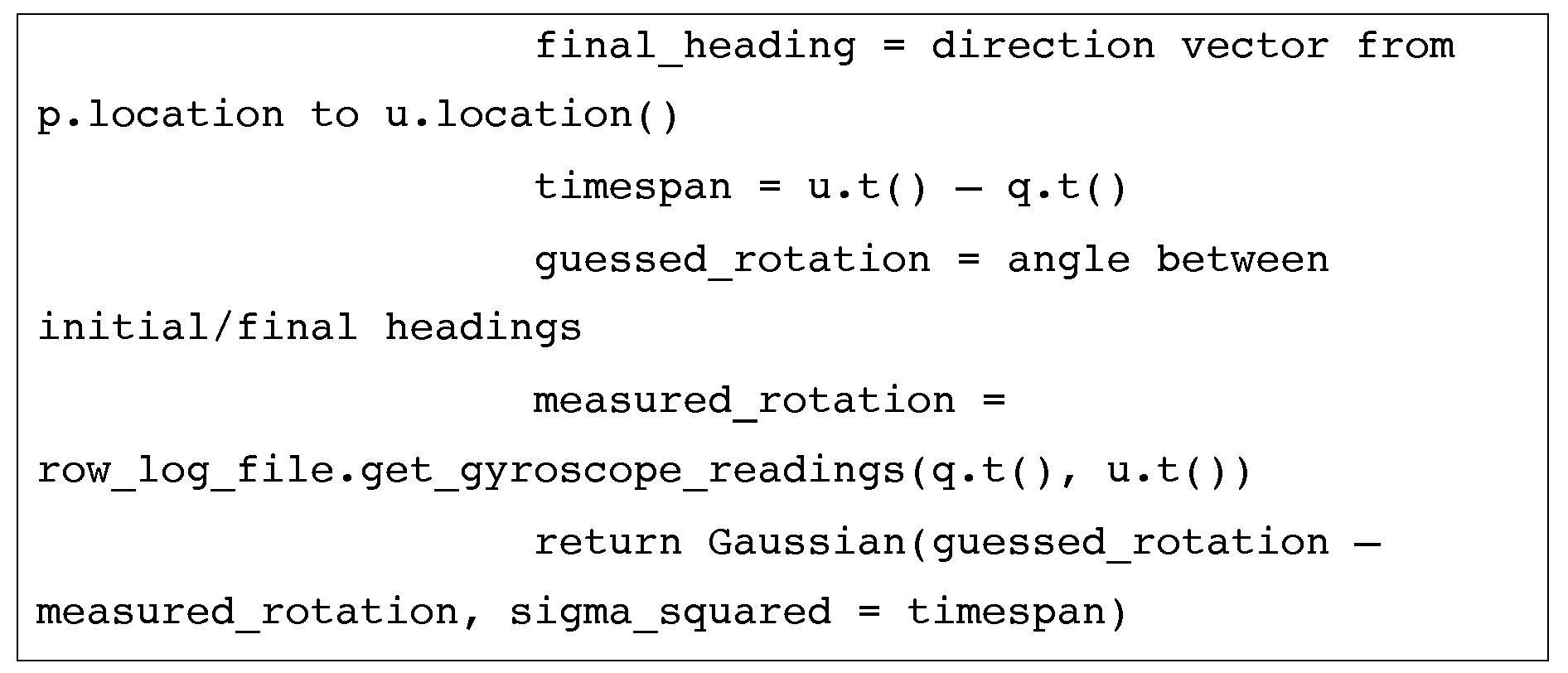
방향 추정에 있어 가우스의 대안으로 일부 실시예에 의해 사용되는 것들은 직사각형 또는 삼각형 커널들을 포함한다. 모바일 기기의 자이로스코프가 유사하게 사용될 수 있다(여기서 q = p 이전의 경로 이력 엔트리):As an alternative to Gaussian for directional estimation, those used by some embodiments include rectangular or triangular kernels. The gyroscope of the mobile device can similarly be used (where the path history entry before q = p):

자이로스코프의 일부 실시예는 검색(search) 함수(아래에 설명됨)가 최적의 값을 찾을 수 있게 해주기 위해 자이로스코프에 대한 추측된 바이어스(guessed bias)를 이용할 수 있다. 추측된 바이어스와 함께 유사한 접근법이 유사하게 나침반 데이터에 적용될 수 있을 것이다.Some embodiments of a gyroscope may use a guessed bias for the gyroscope to allow the search function (described below) to find the optimal value. Similar approaches with inferred bias may similarly be applied to compass data.
실내 특징들에 민감할 수 있는, (나침반과는 다른) 자력계도 자이로스코프 없이 특히 유용할 수 있다. 자력계도 특히 양호한 이동/정지(at rest) 판별 기능일 수 있다. 다음은 일 실시예이고; 자이로스코프 기능과 더 유사하게 다른 실시예들이 구현된다:Magnetometers (other than compasses), which can be sensitive to room features, can also be particularly useful without gyroscopes. The magnetometer may also be a particularly good at rest determination function. The following is an embodiment; Other embodiments are implemented more similarly to the gyroscope function:

개념적으로, 정상 상태(steady state)에서 당신이 몸을 돌리고 있지 않으면, 당신이 똑바로 이동하고 있는 경우 "피트"는 최상이다. 그것이 변화하고 있다면, 당신은 걷고 있거나, 전화기를 회전시키고 있거나 등일 수 있고, 따라서 회전을 자유롭게 놔두기 위해 1의 피트가 반환된다. 그러나, 전화기 움직임은 신체 움직임과 상관없을 수 있다는 것에 유의한다. 예를 들어, 사용자는 그의 몸을 움직이지 않고 그의 전화기를 회전시킬 수 있다.Conceptually, "feet" are best if you are moving straight unless you are in a steady state. If it is changing, you can be walking, spinning the phone or the like, so one foot is returned to leave the rotation free. However, note that phone movement may be independent of body movement. For example, a user can rotate his phone without moving his body.
GPS 피트 함수는 Gaussian(gps_location at u.t( ), gps_confidence_interval at u.t( ))일 수 있다. 진보된 WiFi 시스템, 및 TOF(time-of-flight) 측정 시스템으로부터의 적외선 TDOA(time-difference-of-arrival) 추정치들과 같은 다른 시간 거리 측정(time-ranging) 신호들이 유사하게 포함될 수 있을 것이다.The GPS fit function may be Gaussian (gps_location at u.t (), gps_confidence_interval at u.t ()). Other time-ranging signals, such as infrared time-difference-of-arrival (TDOA) estimates from an advanced WiFi system, and a time-of-flight measurement system, may similarly be included. .
공간이 걷기에 적합한지 여부를 의미하는 점유율(occupancy)이 특히 유용할 수 있다. 일부 실시예에서, 점유율 정보는 signal_snapshot을 통해 암암리에 교환된다. 구체적으로, signal_snapshot의 각 그리드는 50%에서 시작하여, 0에서 100%에 이르는 점유율 값을 갖는 것으로 생각될 수 있다. 로그 데이터가 수집됨에 따라, 신호 스냅샷은 걷기에 적합한 구역 대 그렇지 않은 구역을 반영하기 시작하고 점유율 값이 조정될 수 있을 것이다. 유사한 방식으로, 오래된 경로들이 비사용 공간(dead space)도 식별한다. 일 실시예에서, 로케이션에 대한 raw_log_file들을 사용하여 계산된 오래된 경로들로부터 점유율 맵들이 작성될 수 있다. 점유율 맵들은 단계 320에서 다운로드될 수 있다. 또 다른 실시예들에서, 유사한 방식으로 더 일반적으로 걸은 구역들을 식별하는 풋 트래픽 맵들(foot traffic maps)이 유지될 수 있다.Occupancy, which indicates whether the space is suitable for walking, can be particularly useful. In some embodiments, occupancy information is implicitly exchanged via signal_snapshot. Specifically, each grid of signal_snapshot can be thought of as having occupancy values ranging from 0% to 0%. As log data is collected, signal snapshots will begin to reflect areas suitable for walking versus areas not and the occupancy value may be adjusted. In a similar manner, older paths also identify dead space. In one embodiment, occupancy maps may be created from old paths computed using raw_log_files for the location. The occupancy maps may be downloaded in
블루투스 및 NFC/RFID, 지그비(Zigbee), 크로스-폰 WiFi 탐지(cross-phone WiFi detection) 등의 다른 단거리 무선 기술이 다음의 기본적인 접근법에서 사용될 수 있다(또한, 도시된 블루투스 프로세스는 계산을 위해 로케이션 시스템(120)과의 추가적인 통신, 또는 피어-투-피어 기반으로 이동 기기들 간에 직접 통신을 이용한다):Other short-range wireless technologies, such as Bluetooth and NFC / RFID, Zigbee, cross-phone WiFi detection, can be used in the following basic approaches (also, the illustrated Bluetooth process can be located for computation purposes). Additional communication with system 120, or direct communication between mobile devices on a peer-to-peer basis):


일부 실시예는 사용자들 간의 거리를 추정하기 위해 블루투스 신호 세기 및/또는 3.5 미터 이외의 값들을 이용한다.Some embodiments use values other than Bluetooth signal strength and / or 3.5 meters to estimate the distance between users.
단계 330에서 사용된 피트 함수들은 로케이션 결정에 이용되는 모바일 기기 상의 각종 센서들을 평가하는 데 사용될 수 있는 WiFi와 같은 규제되지 않은 RF 송신들의 신호 스냅샷들을 작성하는 프로세스와 함께 논의되었다. 다음 섹션은 사용자의 로케이션을 결정하기 위해 피트 정보를 사용하는 검색 접근법에 대해 논의할 것이다.The fit functions used in
검색 함수(Search function ( SearchSearch FunctionsFunctions ))
검색 프로세스는 선형 시간에서 선택된 피트 함수가 주어진 경우 최상 피팅 경로 이력(best-fitting path_history)을 찾는 데에 중점을 두고 있다. 제안된 접근법은 궁극적으로 순차적 중요도 리샘플링(sequential importance resampling)을 이용한다. 피트 함수는 순차적 계산을 위해, 예를 들어 path-history를 따른 "추측"을 위해 설계되어 있기 때문에, total_fit는 점증적으로 그리고 시간 순서(chronological order)로 누적된다. 이는 시간 순서로 한 번에 하나의 추측을 함으로써 path-history가 반복적으로 생성될 수 있게 해준다. 그 후, 각 단계에서, 점증적 적합도 스코어(incremental fitness score)만이 비교될 필요가 있고 상위 몇 개가 선택된다. 이는 그리디 검색 프로세스(greedy search process)를 야기한다:The search process focuses on finding the best-fitting path_history given a selected fit function in linear time. The proposed approach ultimately uses sequential importance resampling . Since the fit function is designed for sequential calculation, for example "guessing" along a path-history, total_fit accumulates incrementally and in chronological order. This allows path-history to be generated repeatedly by making one guess at a time in chronological order. Then, at each step, only incremental fitness scores need to be compared and the top few are selected. This causes a greedy search process:


따라서, 이 접근법에서의 개선들은 랜덤 추측을 위한 제안 분포들을 선택하는 것으로부터 나올 것이다. 하나의 접근법은 완전히 랜덤 로케이션들이 아니라 보다 높은 가능성의 구역들에 초점을 맞추는 것이고, 따라서 상기 내부 루프에서의 코드는 next_guess = sample from Gaussian(hypothesis[i].prev_guess.location( ), sigma=5m) and weights[i] *= w/Probsample(next_guess)가 될 수 있다.Thus, improvements in this approach will come from choosing suggested distributions for random guessing. One approach is to focus on areas of higher probability, not completely random locations, so the code in the inner loop is next_guess = sample from Gaussian (hypothesis [i] .prev_guess.location (), sigma = 5m) and weights [i] * = w / Prob sample (next_guess)
다른 경우에 당신은 등가의 분포로부터 샘플링함으로써 센서(예를 들어, 가속도계)의 피트 함수를 계산하는 것을 피할 수 있다. 예를 들어, 가속도계를 사용하여, at_rest == true이면, 이전의 피트 함수가 주어진 경우, 그것은 Gaussian(distance, sigma_squared=0.01)과 부합할 것이다. 추측을 샘플링하고 이어서 피트를 평가하는 대신, 분포, Gaussian(distance, sigma_squared=0.01)로부터 직접 다음 추측이 선택될 수 있다. 이를 구현하는 한 가지 방법은 sigma_squared=0.01에 따라 랜덤 가우스 거리를 생성하고, 당신의 다음 추측을 prev_guess로부터의 그 거리로 설정하는 것이다. 당신의 피트 함수에 상당하는 분포로부터 샘플링할 때, w == Probsample(next guess)이기 때문에 추가 단순화가 이루어질 수 있고, 따라서 weights[i] *= w/Probsample(next_guess)를 갱신할 필요가 없어진다.In other cases you can avoid calculating the fit function of a sensor (eg accelerometer) by sampling from an equivalent distribution. For example, using an accelerometer, if at_rest == true, given the previous fit function, it would match Gaussian (distance, sigma_squared = 0.01). Instead of sampling the guess and then evaluating the pit, the next guess can be selected directly from the distribution, Gaussian (distance, sigma_squared = 0.01). One way to implement this is to generate a random Gaussian distance according to sigma_squared = 0.01 and set your next guess to that distance from prev_guess. When sampling from the distribution corresponding to your fit function, additional simplification can be made because w == Prob sample (next guess), so you need to update weights [i] * = w / Prob sample (next_guess) Disappear.
simple_search( )는 기만적으로 단순하고; 그것은 단계 330이 한 번에 수 백개의 (지능적인) 추측을 신속히 테스트하여 raw_log_file들 및 signal_snapshot으로부터 반복적으로 path_history를 생성하고 이어서 단계 340에서 사용자에게 현재 로케이션을 표시할 수 있게 해준다. 테스트 가설들의 수 500은 오늘날 모바일 기기들의 처리 능력에 기초하여 계산 시간, 전력 사용량, 정확도, 및 반응성의 균형을 유지하기 위해 선택되었다. 미래의 기기들에서 테스트할 가설들의 특정 수는 더 크거나 더 적을 수 있다. 예를 들어, 미래의 기기들에서의 더 큰 계산 능력은 더 적은 수의 추측들의 더 복잡한 분석을 가능하게 하면서 더 나은 결과를 제공할 수 있다. 유사하게, 경로를 갱신하기 위한 0.05초 및 갱신된 WiFi(또는 다른 규제되지 않은 RF 송신들/송신기들)를 스캔하기 위한 1.5초의 선택된 샘플링 간격은 동일한 균형(tradeoffs)에 기반을 두고 있고 마찬가지로 조정될 수 있다.simple_search () is deceptively simple; It allows
신호 signal 맵의Map 추가 개선 Further improvements
신호 스냅샷에 대한 추가 최적화 및 개선이 가능하고 일부 실시예에 따라 사용된다. 먼저, 제한된 관측 데이터의 처리를 생각해보자(예를 들어, 도 2의 로케이션(200)에 처음 방문이고 signal_snapshot에 최소의 데이터가 있다). 이러한 상황에서, 사용자가 실제 경로(250)를 따라 걸어가기 시작함에 따라, signal_snapshot은 데이터를 누적하기 시작할 것이고, 많은 그리드 셀들이 비고 N == 0이다.Further optimizations and improvements to the signal snapshots are possible and used in accordance with some embodiments. First, consider the processing of limited observation data (eg, a first visit to location 200 in FIG. 2 and minimal data in signal_snapshot). In this situation, as the user begins to walk along the
한 가지 접근법은 비어 있는 셀들에 대한 추정된 평균 및 추정된 분산을 계산하는 것이다. 이것은 일 실시예에서 다음과 같이 행해진다. 먼저, global_prior가 계산된다(또는, 예를 들어, 로케이션 시스템(120)으로부터 얻어진다). 글로벌 프라이어(global prior)는 이용 가능한 모든 raw_log_file들 내의 모든 dBm 값들의 전반적인 평균 및 분산으로서 계산될 수 있다. 비어 있는 셀들에 대한 radio_map_cell[mac_address] 파라미터들은 이 global_prior로 초기화될 수 있다. 사용할 로그 파일들의 선택은 구현 특정적이고(implementation-specific); 일부 실시예는 모든 이용 가능한 로그 파일을 사용하는 반면, 다른 실시예들은 이용 가능한 로그 파일들의 일부, 예를 들어, 해당 사용자, 해당 모바일 기기, 해당 일반적인 로케이션에 대해 필터링된 것을 사용할 수 있다. global_prior 대신에, 하나의 셀로부터의 실제 관측들이 이웃 셀들에서 데이터가 이용 가능하게 될 때 사용될 수 있다. 그 셀들에 대한 평균 및 분산을 조정하는 것은 인근의 이웃들에 기초한 일종의 보간법이다. 일 실시예는 관측들의 전파를 최대 거리, 예를 들어, 5 미터로 제한한다. 또한, 일부 실시예는 dBm 단위의 선형 감쇠가 아니라 1/볼트의 단위로 명명된 반직관적인 감쇠 함수를 이용한다. 다른 충분한 통계적 방법들이 사용될 수 있을 것이다(예를 들어, 중간값들, 제곱 평균들의 제곱근).One approach is to calculate the estimated mean and estimated variance for empty cells. This is done in one embodiment as follows. First, global_prior is calculated (or obtained, for example, from location system 120). The global prior can be calculated as the overall average and variance of all dBm values in all available raw_log_files. The radio_map_cell [mac_address] parameters for empty cells can be initialized to this global_prior. The selection of log files to use is implementation-specific; Some embodiments use all available log files, while other embodiments may use some of the available log files, for example, filtered for the user, the mobile device, and the general location. Instead of global_prior, actual observations from one cell can be used when data becomes available in neighboring cells. Adjusting the mean and variance for those cells is a kind of interpolation based on nearby neighbors. One embodiment limits the propagation of the observations to a maximum distance, for example 5 meters. In addition, some embodiments use a semiintuitive attenuation function named in units of 1 / volt rather than linear attenuation in dBm. Other sufficient statistical methods may be used (eg medians, square root of square means).
단위의 선택에 대한 이유는 국부적으로, 신호 세기들이 로그-거리 경로 손실 모델을 따른다는 가정이다. 보간법은 Watts**(-1.0/γ)의 단위의 평균 함수이고, 여기서 γ는 무선 경로 손실 지수(wireless path loss exponent)이다. 근처에 자유 공간이 있는 구역들의 경우, γ = 2.0이 사용될 수 있다. signal_snapshot이 볼트의 단위로 유지된다면, 계산을 위해 평균 및 분산을 1/볼트로 변환하고, 이어서 역은 간단하다.The reason for the choice of units is the local assumption that the signal strengths follow a log-distance path loss model. Interpolation is an average function of units of Watts ** (− 1.0 / γ), where γ is a wireless path loss exponent. For zones with free space nearby, γ = 2.0 can be used. If signal_snapshot is kept in units of volts, convert the mean and variance to 1 / volt for calculation, and then the inverse is simple.
게다가, 일부 실시예는 signal_snapshot 내의 각 셀에 α-값을 할당한다. 관측된 셀들에 대한 α-값은 1.0이고 가장 가까운 관측으로부터 3개의 셀보다 더 떨어져 있는 "비어 있는" 셀들에 대한 α-값은 0.0이다. 관측된 셀 근처의 셀들은 관측에 더 가까운 셀들에 대해 더 높은 α-값을 갖는다. 0.7의 α-값을 가진 셀은 단지 70% 가중치를 가진 그의 보간된 신호 세기를 나타낼 것이다. 나머지 가중치는 균일한 프라이어인, global_prior, 포괄적 분포, 액세스 포인트로부터의 거리에 기초한 휴리스틱(heuristic), 로그-거리 경로 손실 모델에 기초한 휴리스틱의 세트로부터 선택될 수 있다. 관측으로부터의 거리에 기초한 α의 저하는 윈도 함수, 예를 들어, 이차 윈도우(quadratic window)(Epanechnikov), 삼각 윈도ㅇ우riangular window), 불변/직사각형 윈도우(constant/rectangular window)로서 구현될 수 있다.In addition, some embodiments assign α-values to each cell in signal_snapshot. The α-value for the observed cells is 1.0 and the α-value for “empty” cells further than three cells from the closest observation is 0.0. Cells near the observed cell have a higher α-value for the cells closer to the observation. A cell with an α-value of 0.7 will represent its interpolated signal strength with only a 70% weight. The remaining weights may be selected from a set of heuristics based on global_prior, global distribution, heuristics based on distance from access point, and log-distance path loss model, which are uniform fryers. The lowering of α based on the distance from the observation can be implemented as a window function, for example a quadratic window (Epanechnikov), a triangular window, a constant / rectangular window. .
지금까지의 논의에서, signal_snapshot에서의 셀 모양은 균일한 사각형들의 그리드인 것으로 가정되었다. 그러나, 다른 실시예들에서는, 신호 세기들이 가장 강한 곳을 중심으로 하는 로그-폴라(log-polar) 셀들; 신호 세기들이 가장 큰 변화도(gradients)를 가진 곳을 중심으로 하는 로그-폴라 셀들; 크기가 같지는 않은 사각형 셀들을 포함하는 다른 셀 모양들이 사용된다. 예를 들어, 고르지 않은 사각형 셀들을 구현하기 위해 일부 실시예는 단일 셀 그리드에서 시작하여 이것은 충분한 WiFi 관측들이 수신될 때 더 작은 셀들로 나누어지고, 예를 들어, 모든 셀이 적어도 N개의 관측을 갖게 한다.In the discussion so far, it has been assumed that the cell shape in signal_snapshot is a grid of uniform squares. However, in other embodiments, log-polar cells centered where the signal strengths are strongest; Log-polar cells centered where the signal strengths have the largest gradients; Other cell shapes are used, including rectangular cells that are not the same size. For example, to implement uneven rectangular cells, some embodiments start with a single cell grid, which is divided into smaller cells when sufficient WiFi observations are received, for example, all cells have at least N observations. do.
미래의 검색의 추가 개선Further improvements in future searches
지금까지 일부 실시예에서 사용되는 피트 함수들, 검색 전략, 및 신호 맵 개선에 대해 논의하였다. 일부 실시예에서 사용되는 또 다른 기법은 더 나은 스냅샷을 작성하기 위해 더 큰 컬렉션의 로그 파일들에 걸쳐 검색하고 최적화하는 것이다. 도 3의 논의에서, 우리는 모바일 기기로부터 로케이션 시스템(120)으로 그리고 반대로 데이터가 전송되는 옵션의 단계들(단계 320 및 단계 360)을 다루었다.So far, the fit functions, search strategy, and signal map improvement used in some embodiments have been discussed. Another technique used in some embodiments is to search and optimize across a larger collection of log files to create a better snapshot. In the discussion of FIG. 3, we have dealt with optional steps (step 320 and 360) in which data is transferred from the mobile device to the location system 120 and vice versa.
전술한 바와 같이, 모바일 기기(131)로의 하향 전송들 중 하나는 signal_snapshot일 수 있고 로케이션 시스템(120)으로의 상향 전송들 중 하나는 raw_log_file일 수 있다. 일 실시예에 따른 로케이션 결정 프로세스의 개선을 위한 도면인 도 4에 관련하여 하나의 최적화 기법이 논의될 것이다. 게다가, 도 4는 다수의 기기들로부터의 처리가 서버, 예를 들어, 로케이션 시스템(120)에서 행해지는 클라이언트-서버 타입 사용의 컨텍스트에서 설명될 것이다. 일부 실시예에서, 도 4의 프로세스는 모바일 기기에서 해당 기기로부터의 다수의 로그 파일들 및/또는 다른 모바일 기기들로부터 수신된 추가 로그 파일들을 사용하여 수행된다. 이러한 실시예에서, 도 4의 프로세스는 로케이션 소프트웨어(159)에 의해 수행될 수 있다.As described above, one of the downlink transmissions to the mobile device 131 may be signal_snapshot and one of the uplink transmissions to the location system 120 may be raw_log_file. One optimization technique will be discussed with respect to FIG. 4, which is a diagram for improving a location determination process, according to one embodiment. In addition, FIG. 4 will be described in the context of client-server type usage where processing from multiple devices is done at a server, eg, location system 120. In some embodiments, the process of FIG. 4 is performed at a mobile device using multiple log files from that device and / or additional log files received from other mobile devices. In such an embodiment, the process of FIG. 4 may be performed by location software 159.
앞에 논의된 signal_snapshot 데이터 구조로 돌아가서, 추가(append) 함수는 쉬운 크라우드소싱(crowdsourcing), 자기 회복(self-healing)(signal_snapshot의 변화들에 응답), 및 실시간 위치 확인(real-time localization)을 허용하는 실시예에 따라 설명되었다. 일부 실시예들은 로케이션 시스템(120) 상의 이들 기능 중 일부 또는 몇몇을 수행하여 모바일 기기에 대한 처리 부담, 네트워크 대역폭, 및 응답 시간을 줄일 수 있다. 게다가, 서버에서 이 정보를 처리하는 것은, 사용자들에게 더 나은 로케이션 결정을 제공하는 것 외에, 회사 분석(company analytics)도 제공할 수 있다. 구체적으로, 다수의 방문들(상이한 사용자들, 상이한 기기들)로부터의 raw_log_file들을 종합함으로써, 더 큰 데이터베이스의 측정치들에 걸친 공동 추측이 가능하다. 구체적으로, 모든 raw_log_file들이 시간 순서로 놓여 있다면; 각 추측에 대해 시간 순서로 fit_function이 계산되며; fit_function의 반복 동안에, 시스템은 signal_snapshot을 계속해서 누적하고; 미래의 반복을 위해 최신의 누적된 signal_snapshot을 사용하여 계속한다. 구현을 위해, 일부 실시예는 단계 360에서 raw_log_file들을 업로드하고 단계 320에서 signal_snapshot들을 다운로드한다.Returning to the signal_snapshot data structure discussed earlier, the append function allows easy crowdsourcing, self-healing (in response to changes in signal_snapshot), and real-time localization. It was described according to the embodiment. Some embodiments may perform some or some of these functions on location system 120 to reduce processing burden, network bandwidth, and response time for mobile devices. In addition, processing this information at the server may provide company analytics in addition to providing users with better location decisions. Specifically, by combining raw_log_files from multiple visits (different users, different devices), co-guess over the measurements of a larger database is possible. Specifically, if all raw_log_files are in chronological order; Fit_function is computed in chronological order for each guess; During an iteration of fit_function, the system continues to accumulate signal_snapshot; Continue using the latest accumulated signal_snapshot for future iterations. For implementation, some embodiments upload raw_log_files in
도 4는 단계 410에서 로케이션으로부터 측정 스트림들, 예를 들어, raw_log_file들을 수집하는 것으로 시작되는 프로세스(400)를 포함한다. 예를 들어, 다수의 모바일 기기들(및 그의 사용자들)이 로케이션(220)을 방문하면, 이용 가능한 다수의 raw_log_file들이 있을 수 있다. 그 측정 스트림들 중 일부는 단일 사용자/모바일 기기로부터의 것일 수 있다. 예를 들어, 식료품점 예에서, 사용자(210)가 종업원이라면, 그는 대향의 이용 가능한 측정 스트림들을 설명할 수 있다. 프로세스(400)는 단계 420에서 다른 것들을 사용하여 측정 스트림을 분석하는 것으로 계속되고, 이는 아래에 더 상세히 설명된다. 일 실시예에서, 단계 420은 raw_log_file들에 확률적 좌표 상승(stochastic coordinate ascent)을 적용하는 것을 통해 달성된다. 이것은 자기 유도 기계 학습(self-guided machine learning)의 적용으로 간주될 수 있다. 단계 420의 결과는 단계 430에서 생성되는 갱신된 signal_snapshot이다.4 includes a process 400 that begins with collecting measurement streams, eg, raw_log_files, from a location in step 410. For example, if multiple mobile devices (and their users) visit the location 220, there may be multiple raw_log_files available. Some of the measurement streams may be from a single user / mobile device. For example, in a grocery store example, if user 210 is an employee, he may describe the opposite available measurement streams. Process 400 continues with analyzing the measurement stream using others at
단계 420의 세부 사항으로 화제를 돌려, 더 나은 signal_snapshot을 작성하기 위해 앞에 설명한 simple_search( ) 접근법의 변형이 사용될 수 있다. 단계 420에서, 위에 설명한 simple_search( )는 시간 순서로 각각의 raw_data_log에 대해 실행될 수 있다. 다른 순서들도 가능한데, 예를 들어, 가장 최근의 것이 먼저 실행되거나, 가장 긴 지속기간이 먼저 실행되거나, 가장 많은 사용자 상호 작용을 가진 가장 신뢰할 수 있는 기여자들(예를 들어, 과거 이력에 기초)이 먼저 실행되거나, 등등이다.Turning to the details of
이 초기화의 끝에, 각각의 raw_log_file에 대한 하나의 경로가 simple_search( )의 그 실행에 대한 최고 가중치, 예를 들어, best_hypothesis_so_far[logfileID]를 가질 것이다. 그 후, 각각의 "차원(dimension)"의 반복적 개선이 발생할 수 있다. 이 예에서, 데이터베이스는 사용중인 로그 파일들의 컬렉션을 나타낸다:At the end of this initialization, one path for each raw_log_file will have the highest weight for its execution of simple_search (), for example best_hypothesis_so_far [logfileID]. Thereafter, iterative improvement of each "dimension" may occur. In this example, the database represents a collection of log files in use:


루프가 수행되는 순서는 구현 특정적인 것으로, 예를 들어, 역방향/순방향 시간 순서, 랜덤이다. 도시된 바와 같이, i까지 모든 이전에 탐사된 차원들이 simple_search( )를 재실행하기 위한 signal_snapshot을 작성하는 데 사용된다. 상기 코드는 신호 스냅샷들 1...i-1을 추가하고 있지만, 더 일반적으로 그것은 좌표 상승을 수행하고 있을 때 i를 제외한 전부일 수 있다. 또한 서버에서 수행될 경우, simple_search( )가 모바일 기기에서 수행되는 경우와 비교하여 더 복잡한 계산들 및/또는 더 큰 검색 공간, 예를 들어, 500 초과가 사용될 수 있다.The order in which the loops are performed is implementation specific, eg reverse / forward time order, random. As shown, all previously explored dimensions up to i are used to create a signal_snapshot for rerunning simple_search (). The code is adding signal snapshots 1 ... i-1, but more generally it may be everything except i when performing coordinate elevation. Also, when performed on a server, more complex calculations and / or a larger search space, such as greater than 500, may be used compared to when simple_search () is performed on a mobile device.
데이터에 아웃라이어 기각 기법들을 적용하는 것을 포함한 추가 개선들이 이루어진다. 일관성 있는 아웃라이어들의 그룹은 건물의 상이한 층들일 공산이 있고 적절한 경우 개별 signal_snapshot 및/또는 로그 파일들의 컬렉션으로 분리될 수 있다. 이러한 능력은 일부 실시예에서 다층 실내 환경의 개선된 처리를 제공한다. 독립형 아웃라이어들은 데이터로부터 제거될 수 있는 이동된/제거된 송신기들을 포함할 수 있고 및/또는 해당 로그 파일 전체가 고려에서 제거되어야 한다. 예를 들어, WiFi 환경에서 별개의 변화들이 발생하면 시스템은 특정 시점 후에는 로그들이 일관되게 더 낮은 가능성이고 해당 시점 전에 비하여 악화될 것임을 탐지할 것이다.Further improvements are made, including applying outlier rejection techniques to the data. Groups of consistent outliers are likely to be different floors of the building and can be separated into a collection of individual signal_snapshot and / or log files, as appropriate. This capability provides in some embodiments an improved treatment of a multilayer indoor environment. Standalone outliers may include moved / removed transmitters that may be removed from the data and / or the entire log file should be removed from consideration. For example, if separate changes occur in the WiFi environment, the system will detect that after a certain point of time the logs are consistently lower likelihood and will be worse than before that point.
WiFi 환경은 규제되지 않기 때문에, 즉 애드 혹(ad hoc)이기 때문에, 이들은 정기적으로 바뀌는 경향이 있다. 이러한 이유로, 어떤 기간, 예를 들어, 3-6 개월 후에는 오래된 로그 파일들을 처분하는 것이 바람직할 수 있다. 일부 실시예에서, 더 많은 양의 더 새로운 로그 파일들을 가진 로케이션들의 오래된 로그 파일들은 더 적은 로그 파일들을 가진 로케이션들보다 더 빨리 처분된다. 따라서, 예를 들어, 도 2의 로케이션(220)이 날마다 수십의 로그 파일들이 생성되는 방문이 많은 식료품점이라면, 3개월 이상의 오래된 파일들의 값은 몇 개월에 한 번의 방문만 있고 더 오랜 기간 동안 로그 파일들을 보존하는 것이 유익할 수 있는 로케이션들의 경우보다는 더 낮다.Because the WiFi environment is not regulated, that is, ad hoc, they tend to change regularly. For this reason, it may be desirable to dispose of old log files after some period of time, for example 3-6 months. In some embodiments, old log files of locations with a larger amount of newer log files are disposed faster than locations with fewer log files. Thus, for example, if the location 220 of FIG. 2 is a grocery store with many visits in which dozens of log files are generated per day, the value of older files of three months or more may only have one visit every few months and log for longer periods of time. Preserving files is lower than in the case of locations where it can be beneficial.
예시 및 추가 논의Example and further discussion
앞에 설명한 도 3-4의 프로세스들은 도 2의 시나리오(200)의 예뿐만 아니라 시나리오(200)의 변형의 로케이션 결정 프로세스의 실시예들로부터의 예시의 결과들을 보여주는 도 5-6에 관련하여 설명될 것이다. 구체적으로, 도 5는 사용자(210), 모바일(131) 및 관련 요소들이 제거되고 계산된 경로(510)가 도시된 도 2와 동일한 시나리오(500)를 보여주고 있다. 유사하게 도 6은 도 5와 같이 도 2의 요소들을 생략하고 대안의 계산된 경로(610)를 보여주는 시나리오(600)를 보여주고 있다. 도 5-6에서 계산된 경로들은 각각의 t0 내지 t7에서 계산된 로케이션을 보여주는 c0 내지 c7이 주석으로 달려 있다.The processes of FIGS. 3-4 described above will be described with reference to FIGS. 5-6 showing examples of the scenario 200 of FIG. 2 as well as examples of results from embodiments of the location determination process of a variant of the scenario 200. will be. Specifically, FIG. 5 shows the same scenario 500 as in FIG. 2 where the user 210, mobile 131 and related elements have been removed and the
이 논의에서, 로케이션(220)은 식료품점이고 장애물들(222-228)은 그 상점의 통로들과 선반들이다. 이 논의에서, 로케이션 시스템(120)은 예를 들어 프로세스(300)의 단계 320에서 예를 들어 회사 정보(112) 또는 공공 웹사이트, 예를 들어 크라우드 소싱된 맵 웹사이트로부터 그 상점의 축척의, 또는 대략 축척의 맵을 모바일(131)에 제공하였다. 도 5의 논의에서는, 로케이션 시스템(120)과 모바일(131)에 이용 가능한 신호 스냅샷이 없었고 이번이 로케이션(220)으로의 첫 번째 방문이라고 가정할 것이다.In this discussion, location 220 is a grocery store and obstacles 222-228 are the aisles and shelves of that store. In this discussion, location system 120 may, for example, at
모바일(131)은 신호 스냅샷(예를 들어, signal_snapshot 데이터 구조)을 작성하고 이어서 1.5초마다 이를 갱신하고 있을 것이고 모바일(131)의 가속도계가 사용될 것이다. 이 예에서, 모바일(131)은 단계 330에서 처음으로 측정 수집을 시작할 수 있고 단계 320에서 맵을 얻는 데 사용된 GPS에 기초하여 사용자에게 맵 상에서 그들이 있는 곳을 터치하라고 프롬프트할 수 있다(단계 350). 이 특정한 예에서는, 경로의 방위를 맞추기 위해 어떤 추가 입력이 필요할 것이다. 그러한 추가 입력이 없다면, 이번이 이 로케이션으로의 첫 번째 방문임을 고려해볼 때 경로는 방위가 없을 것이고 signal_snapshot은 로케이션 특정적인 정보가 없다. 이 추가 입력은 센서, 예를 들어, 나침반 헤딩으로부터, 두 번째 사용자 터치, 예를 들어 페이싱, 또는 몇 초 후에 "지금 여기에 있습니다(I'm here now)"로부터 올 수 있다. 로케이션은 실제 로케이션 t0에 대해 c0로서 도시되어 있다. 처음에 입력을 수신하기 전에 표시된 로케이션은 디스플레이 상의 다른 곳에 있었을 수 있지만(단계 340); 그 최초 "언앵커(unanchored)" 로케이션은 도 5에 도시되어 있지 않다는 점에 유의한다.The mobile 131 will be creating a signal snapshot (eg signal_snapshot data structure) and then updating it every 1.5 seconds and the accelerometer of the mobile 131 will be used. In this example, the mobile 131 may begin collecting measurements for the first time in
사용자가 t0에서 t1으로 경로를 따라 걸어감에 따라, 로그 파일이 유지되고 신호 스냅샷이 작성된다. 신호 스냅샷은 무선 액세스 포인트들(232-238)로부터의 수신된 WiFi 송신들을 반영한다. c0에서 c1으로의 계산된 경로(510)와 실제 경로(250) 사이의 편차는 로그 데이터에 대해 최적 피트인 선택된 추측들을 반영한다. 시나리오(500)에서, 우리는 이 로케이션에 한 번도 방문한 적이 없어서 점유율 데이터가 없고(예를 들어, 장애물들(222-228)이 프로세서가 사용할 수 있는 형식으로 반영되어 있지 않고) 기존의 신호 스냅샷이 없다.As the user walks along the path from t 0 to t 1 , the log file is maintained and a signal snapshot is taken. The signal snapshot reflects received WiFi transmissions from wireless access points 232-238. The deviation between the
이에 반해서, 시나리오(600)를 가진 도 6은 계산된 경로(610)를 보여주는데(다시 마커들 c0 내지 c7으로), 이는 실제 경로에 더 가까운 피트이다. 시나리오(600)는 로그 파일들을 분석하고 더 많은 유용한 신호 스냅샷을 얻기 위해 도 4의 프로세스(400)와 같은 프로세스가 사용된 더 많은 방문 후의 시나리오를 반영한다. 이 예에서는, 모바일 기기들(엔드 포인트들(130))을 가진 5백 명의 고객이 로케이션(220)을 방문하였고 로케이션 소프트웨어(159)는 로케이션 시스템(120)에 로그 파일들을 송신하고 있다. 이어서 프로세스(400)를 사용하여 다수의 측정치들에 기초하여 조건들을 더 많이 반영하는 신호 맵을 작성하였다. 그 신호 맵은 시나리오(600)에서 모바일(131)이 사용자의 로케이션을 더 정확하게 결정하는 데 사용될 수 있다. 게다가, c0의 위치를 찾아내기 위해 사용자 입력이 필요했을 수 있는 시나리오(500)와는 다르게, 시나리오(600)에서는, 가시적인 WiFi MAC 어드레스들과 이들의 신호 세기의 조합이면 초기 로케이션 결정에 충분할 공산이 있다.In contrast, FIG. 6 with scenario 600 shows the calculated path 610 (again with markers c 0 to c 7 ), which is a pit closer to the actual path. Scenario 600 reflects a post-visit scenario where a process such as process 400 of FIG. 4 was used to analyze log files and obtain more useful signal snapshots. In this example, 500 customers with mobile devices (end points 130) visited location 220 and location software 159 is sending log files to location system 120. Process 400 was then used to create a signal map that more reflects the conditions based on the multiple measurements. The signal map can be used by the mobile 131 to more accurately determine the user's location in scenario 600. In addition, unlike scenario 500, where user input may have been needed to locate c 0 , in scenario 600, the combination of visible WiFi MAC addresses and their signal strength is likely to be sufficient for initial location determination. There is this.
2개의 결과를 대조하는 것은 유익하다. 시나리오(500)에서는, 계산된 경로(510)가 실제 경로(250)와 많은 특징들을 공유하는 반면 시나리오(600)에서는, 계산된 경로(610)가 실제 경로(250)를 더 많이 가깝게 추적한다. 시나리오(500)에서는, 초기 로케이션 결정을 위해 GPS 및/또는 사용자 입력이 도움이 되었지만, 시나리오(600)에서는 그것이 불필요하였다. 2개의 시나리오 사이의 다른 차이점들은 시나리오(500) 대 시나리오(600)에서 비-WiFi 피트 함수들의 더 큰 의존성 및/또는 가중을 포함할 수 있다. 구체적으로, 시나리오(500)에서는 적절한 신호 스냅샷이 작성될 때까지 관성 센서들(예를 들어, 가속도계, 나침반, 자이로스코프, 헤딩 등)이 특히 중요할 수 있다. 대안으로, 관성 센서들 대신에, 점유율 맵 및/또는 사용자 입력, 예를 들어, "여기 있습니다(here I am)"가 새로이 개발중인 신호 스냅샷을 보충하기 위해 사용될 수도 있다. 시나리오(500)는 또한 로케이션에 어떤 전제 조건도 붙어있지 않았다는 사실을 강조한다. 무선 액세스 포인트들(232-238)의 로케이션들에 관해 어떤 정보도 요구되지 않았고 이 예에서 맵을 사용하는 것은 단지 논의와 도식화의 편의를 위한 것이었다. 특히, 오직 한 명의 사용자만이 데이터를 수집하고 있고 그것을 완전히 오프라인으로 하고 있다고 할지라도, 신호 스냅샷은 추가 방문에 의해 개선되므로, 과거와 미래 로케이션 결정이 시간이 지남에 따라 좋아진다. 로케이션으로의 처음 방문/완전 시작(cold start)을 개선할 수 있는 다른 실시예들은 의도된 걷기 경로를 제공하는 것, 예를 들어, 사용자가 상점을 통해 그의 계획된 경로를 그려보는 것을 포함할 수 있다.It is beneficial to contrast the two results. In scenario 500, the
시나리오(600)에서는, 로케이션 시스템(120)이 이전 방문들 및 로그 파일들에 기초하여 점유율 맵을 작성하는 것도 가능할 수 있다. 예를 들어, 상점을 통한 500개의 경로에 걸쳐, 아무도 장애물(222)이 있는 곳을 걸은 적이 없다면, 장애물(222)은 모바일 기기의 피트 함수로의 입력용으로 점유된 공간/걸을 수 없는 곳으로 차단될 수 있다.In scenario 600, it may also be possible for location system 120 to create a occupancy map based on previous visits and log files. For example, over 500 paths through a store, if no one has ever walked where there is an
더 상세한 이력들을 가진 로케이션들은 샘플링 레이트에 대한 변경들을 허용할 수도 있다. 예를 들어, 어떤 환경이 정기적으로 수만의 방문을 갖고 있다면, 정확도를 유지하면서 전력을 아끼기 위해 모바일 기기에서의 샘플링 빈도들을 줄이는 것이 가능할 수 있다. 아주 많이 방문되는 로케이션들에서조차, 로케이션의 어떤 부분들은 다른 부분들보다 덜 빈번하게 방문될 수 있다. 따라서 데이터 보유에 선택성이 적용될 수 있고, 예를 들어, 로케이션의 통행량이 덜한 부분들은 훨씬 더 많이 방문되는 구역들보다 더 긴 데이터 스트림들을 갖도록 보장할 수 있다.Locations with more detailed histories may allow changes to the sampling rate. For example, if an environment has tens of thousands of visits on a regular basis, it may be possible to reduce the sampling frequencies on a mobile device to save power while maintaining accuracy. Even in highly visited locations, some parts of the location may be visited less frequently than others. Selectivity can thus be applied to data retention, for example, where less traffic portions of a location can be guaranteed to have longer data streams than much more visited areas.
결론 및 추가 Conclusion and addition 실시예들Examples
지금까지 개선된 모바일 로케이션 결정을 제공하는 시스템 및 프로세스들에 대해 설명하였다.So far, the systems and processes that provide improved mobile location decisions have been described.
몇몇 추가의 실시예들 및 특징들은 다음과 같은 것들을 포함한다:Some further embodiments and features include the following:
![]()
![]()
![]()
![]()
대화식 게임들 및 증가된 현실감, 예를 들어, Interactive games and increased realism, for example
![]()
![]()
![]()
![]()
![]()
![]()
![]()
![]()
![]()
![]()
![]()
![]()
![]()
![]()
![]()
![]()
![]()
![]()
![]()
![]()
![]()
![]()
![]()
![]()
![]()
![]()
![]()
![]()
![]()
![]()
![]()
![]()
![]()
![]()
![]()
![]()
![]()
![]()
![]()
![]()
![]()
![]()
![]()
![]()
![]()
![]()
![]()
![]()
![]()
![]()
![]()
![]()
![]()
![]()
![]()
![]()
![]()
![]()
![]()
![]()
![]()
![]()
![]()
![]()
![]()
![]()
![]()
![]()
![]()
![]()
![]()
![]()
![]()
![]()
![]()
![]()
![]()
![]()
![]()
![]()
![]()
![]()
![]()
![]()
![]()
![]()
![]()
![]()
![]()
![]()
![]()
![]()
![]()
![]()
![]()
![]()
![]()
![]()
![]()
![]()
![]()
![]()
![]()
![]()
![]()
![]()
![]()
![]()
![]()
![]()
![]()
![]()
![]()
![]()
![]()
![]()
![]()
![]()
![]()
![]()
![]()
![]()
![]()
![]()
![]()
![]()
![]()
![]()
![]()
![]()
![]()
![]()
![]()
![]()
![]()
![]()
![]()
![]()
![]()
![]()
![]()
![]()
![]()
![]()
![]()
![]()
![]()
![]()
![]()
![]()
![]()
![]()
![]()
![]()
![]()
![]()
![]()
![]()
![]()
![]()
![]()
![]()
![]()
![]()
![]()
![]()
![]()
![]()
![]()
![]()
![]()
![]()
![]()
![]()
![]()
![]()
![]()
![]()
![]()
![]()
![]()
![]()
![]()
![]()
![]()
![]()
![]()
![]()
위에 설명하거나 언급한 임의의 데이터 구조들 및 코드는 많은 실시예에 따라 컴퓨터 판독가능 저장 매체에 저장되고, 이 저장 매체는 컴퓨터 시스템이 사용하는 코드 및/또는 데이터를 저장할 수 있는 임의의 장치 또는 매체일 수 있다. 이것은 휘발성 메모리, 비휘발성 메모리, 주문형 집적 회로(ASIC), 필드 프로그래머블 게이트 어레이(FPGA), 디스크 드라이브, 자기 테이프, CD(콤팩트 디스크), DVD(디지털 다용도 디스크 또는 디지털 비디오 디스크)와 같은 자기 및 광 저장 장치, 또는 지금 공지되어 있거나 차후에 개발되는 컴퓨터 판독가능 매체를 저장할 수 있는 다른 매체를 포함하지만, 이들에 제한되는 것은 아니다.Any data structures and codes described or mentioned above are stored in computer readable storage media in accordance with many embodiments, which storage media are any device or media capable of storing code and / or data used by a computer system. Can be. This includes magnetic and optical devices such as volatile memory, nonvolatile memory, application specific integrated circuits (ASICs), field programmable gate arrays (FPGAs), disk drives, magnetic tapes, compact discs (CDs), DVDs (digital versatile discs or digital video discs). Storage devices, or other media capable of storing computer readable media, now known or later developed, are not limited to these.
앞선 설명은 본 발명의 실시 및 사용이 가능하도록 제시되어 있다. 개시된 실시예들에 대한 다양한 수정들이 명백할 것이고, 본 명세서에 정의된 일반 원리들은 본 발명의 사상 및 범위에서 벗어나지 않고서 다른 실시예들과 응용예들에 적용될 수 있다. 따라서, 본 발명은 제시된 실시예들에 제한되는 것이 아니며, 본 명세서에 개시된 원리들 및 특징들과 일관된 가장 넓은 범위가 부여되어야 한다. 본 발명의 범위는 첨부한 청구항들에 의해 정의된다.The foregoing description is presented to enable implementation and use of the present invention. Various modifications to the disclosed embodiments will be apparent, and the generic principles defined herein may be applied to other embodiments and applications without departing from the spirit and scope of the invention. Thus, the present invention should not be limited to the embodiments presented, but should be accorded the widest scope consistent with the principles and features disclosed herein. The scope of the invention is defined by the appended claims.
Claims (26)
상기 모바일 기기에서 신호 스냅샷을 결정하는 단계 - 상기 신호 스냅샷은 상기 모바일 기기가 탐지할 수 있는 규제되지 않은(unregulated) 무선 주파수(RF) 송신들의 특징들을 묘사함 -;
상기 신호 스냅샷과 상기 모바일 기기로부터의 적어도 하나의 추가 입력을 사용하여 상기 모바일 기기에서 상기 사용자의 로케이션을 생성하는 단계; 및
시간이 흐르면서 상기 모바일 기기에서 상기 결정하는 단계와 상기 생성하는 단계를 되풀이하여 반복하고 상기 사용자의 로케이션과 상기 신호 스냅샷을 갱신하는 단계
를 포함하는 방법.A method of creating a location for a user using a mobile device,
Determining a signal snapshot at the mobile device, wherein the signal snapshot depicts features of unregulated radio frequency (RF) transmissions that the mobile device can detect;
Creating a location of the user at the mobile device using the signal snapshot and at least one additional input from the mobile device; And
Over time repeating the determining and generating steps in the mobile device and updating the user's location and the signal snapshot
≪ / RTI >
저장소,
사용자 입력 메커니즘,
센서,
규제되지 않은 무선 주파수(RF) 신호들을 수신하기 위한 수신기, 및
상기 저장소, 상기 사용자 입력 메커니즘, 상기 센서, 및 상기 수신기와 통신하게 연결된 컴퓨터 시스템을 포함하고,
상기 컴퓨터 시스템은 컨트롤러를 포함하고,
상기 컨트롤러는
상기 모바일 기기에서 신호 스냅샷을 결정하고 - 상기 신호 스냅샷은 상기 수신기가 탐지할 수 있는 규제되지 않은 무선 주파수(RF) 송신들의 특징들을 묘사함 -;
상기 신호 스냅샷, 및 상기 사용자 입력 메커니즘과 상기 센서 중 하나로부터의 적어도 하나의 입력을 사용하여 상기 모바일 기기에서 사용자의 로케이션을 생성하고;
시간이 흐르면서 상기 컨트롤러에서 상기 결정과 생성을 되풀이하여 반복하고 상기 사용자의 로케이션과 상기 신호 스냅샷을 갱신하는 모바일 기기.As a mobile device,
Storage,
User input mechanism,
sensor,
A receiver for receiving unregulated radio frequency (RF) signals, and
A computer system in communication with the storage, the user input mechanism, the sensor, and the receiver,
The computer system includes a controller,
The controller
Determine a signal snapshot at the mobile device, the signal snapshot depicting features of unregulated radio frequency (RF) transmissions that the receiver can detect;
Create a location of a user at the mobile device using the signal snapshot and at least one input from one of the user input mechanism and the sensor;
And the controller repeats the determination and generation over time and updates the user's location and the signal snapshot over time.
상기 결정은,
처음에 상기 신호 스냅샷을 결정하기에 앞서 상기 네트워크 인터페이스를 사용하여 서버로부터 상기 신호 스냅샷을 획득하는 것을 더 포함하는 모바일 기기.The method of claim 9 further comprising a network interface,
The determination,
And initially obtaining the signal snapshot from a server using the network interface prior to determining the signal snapshot.
상기 센서는 관성 센서, 자이로스코프, 나침반, 자력계, 및 가속도계를 포함하는 집합으로부터 선택되고;
상기 사용자 입력 메커니즘은 키보드, 터치 감응 디스플레이, 오디오 입력, 및 비디오 입력의 집합으로부터 선택되는 모바일 기기.10. The method of claim 9,
The sensor is selected from a set comprising an inertial sensor, a gyroscope, a compass, a magnetometer, and an accelerometer;
The user input mechanism is selected from a set of keyboards, touch sensitive displays, audio inputs, and video inputs.
복수의 무선 주파수 송신의 복수의 샘플에 대한 신호 정보를 획득하는 단계 - 상기 신호 정보는 복수의 상이한 수신기에 의해 상이한 시간에 획득됨 -;
상기 신호 정보로부터 신호 스냅샷을 생성하는 단계; 및
상기 신호 스냅샷을 사용하여 상기 모바일 기기에서 상기 사용자의 로케이션을 계산하는 단계
를 포함하는 방법.A method for determining a user's location on a mobile device,
Obtaining signal information for a plurality of samples of the plurality of radio frequency transmissions, wherein the signal information is obtained at different times by a plurality of different receivers;
Generating a signal snapshot from the signal information; And
Calculating a location of the user at the mobile device using the signal snapshot
≪ / RTI >
상기 모바일 기기에서 신호 스냅샷을 결정하는 단계 - 상기 신호 스냅샷은 상기 모바일 기기가 탐지할 수 있는 규제되지 않은 무선 주파수(RF) 송신들의 특징들을 묘사함 -;
상기 신호 스냅샷을 사용하여 상기 모바일 기기에서 사용자의 로케이션을 생성하는 단계;
상기 사용자의 로케이션에 기초하여 상품 정보를 획득하는 단계 - 상기 상품 정보는 상기 사용자의 로케이션의 부근에 있는 판매용 제품들에 관한 정보와 관련 있음 -;
시간이 흐르면서 상기 모바일 기기에서 상기 결정하는 단계와 상기 생성하는 단계를 반복하고 상기 사용자의 로케이션과 상기 신호 스냅샷을 갱신하는 단계; 및
상기 사용자의 로케이션과 상기 상품 정보에 기초하여 컨텍스트 정보(contextual information)를 선택적으로 표시하는 단계
를 포함하는 방법.To shop using a mobile device,
Determining a signal snapshot at the mobile device, wherein the signal snapshot depicts features of unregulated radio frequency (RF) transmissions that the mobile device can detect;
Creating a location of a user at the mobile device using the signal snapshot;
Obtaining product information based on the user's location, wherein the product information is related to information about products for sale in the vicinity of the user's location;
Repeating the determining and generating at the mobile device over time and updating the location and the signal snapshot of the user; And
Selectively displaying contextual information based on the user's location and the product information
≪ / RTI >
상기 모바일 기기에서 신호 스냅샷을 결정하는 단계 - 상기 신호 스냅샷은 상기 모바일 기기가 탐지할 수 있는 규제되지 않은 무선 주파수(RF) 송신들의 특징들을 묘사함 -;
상기 신호 스냅샷을 사용하여 상기 모바일 기기에서 사용자의 로케이션을 생성하는 단계;
상기 사용자의 로케이션에 기초하여 컨벤션 정보를 획득하는 단계 - 상기 상품 정보는 상기 사용자의 로케이션의 부근에 있는 컨벤션 부스들(convention booths)에 관한 정보와 관련 있음 -;
시간이 흐르면서 상기 모바일 기기에서 상기 결정하는 단계와 상기 생성하는 단계를 반복하고 상기 사용자의 로케이션과 상기 신호 스냅샷을 갱신하는 단계; 및
상기 사용자의 로케이션과 상기 상품 정보에 기초하여 컨텍스트 정보를 선택적으로 표시하는 단계
를 포함하는 방법.As a method of using a mobile device,
Determining a signal snapshot at the mobile device, wherein the signal snapshot depicts features of unregulated radio frequency (RF) transmissions that the mobile device can detect;
Creating a location of a user at the mobile device using the signal snapshot;
Obtaining convention information based on the user's location, wherein the product information is related to information about convention booths in the vicinity of the user's location;
Repeating the determining and generating at the mobile device over time and updating the location and the signal snapshot of the user; And
Selectively displaying context information based on the user's location and the product information
≪ / RTI >
상기 모바일 기기에서 신호 스냅샷을 결정하는 단계 - 상기 신호 스냅샷은 상기 모바일 기기가 탐지할 수 있는 규제되지 않은 무선 주파수(RF) 송신들의 특징들을 묘사함 -;
상기 신호 스냅샷을 사용하여 상기 모바일 기기에서 사용자의 로케이션을 생성하는 단계;
상기 사용자의 로케이션에 기초하여 소셜 로케이션 정보를 획득하는 단계 - 상기 소셜 로케이션 정보는 상기 사용자의 로케이션의 부근에 있는 다른 사용자들에 관한 정보와 관련 있음 -;
시간이 흐르면서 상기 모바일 기기에서 상기 결정하는 단계와 상기 생성하는 단계를 반복하고 상기 사용자의 로케이션과 상기 신호 스냅샷을 갱신하는 단계; 및
상기 사용자의 로케이션과 상기 소셜 로케이션 정보에 기초하여 컨텍스트 정보를 선택적으로 표시하는 단계
를 포함하는 방법.As a method of using a mobile device,
Determining a signal snapshot at the mobile device, wherein the signal snapshot depicts features of unregulated radio frequency (RF) transmissions that the mobile device can detect;
Creating a location of a user at the mobile device using the signal snapshot;
Obtaining social location information based on the user's location, wherein the social location information is related to information about other users in the vicinity of the user's location;
Repeating the determining and generating at the mobile device over time and updating the location and the signal snapshot of the user; And
Selectively displaying context information based on the user's location and the social location information
≪ / RTI >
Applications Claiming Priority (3)
| Application Number | Priority Date | Filing Date | Title |
|---|---|---|---|
| US201161439876P | 2011-02-05 | 2011-02-05 | |
| US61/439,876 | 2011-02-05 | ||
| PCT/US2012/020875 WO2012106075A1 (en) | 2011-02-05 | 2012-01-11 | Method and apparatus for mobile location determination |
Publications (2)
| Publication Number | Publication Date |
|---|---|
| KR20130132599A true KR20130132599A (en) | 2013-12-04 |
| KR101534995B1 KR101534995B1 (en) | 2015-07-07 |
Family
ID=46603036
Family Applications (1)
| Application Number | Title | Priority Date | Filing Date |
|---|---|---|---|
| KR1020137023510A KR101534995B1 (en) | 2011-02-05 | 2012-01-11 | Method and apparatus for mobile location determination |
Country Status (6)
| Country | Link |
|---|---|
| US (1) | US9749780B2 (en) |
| EP (1) | EP2671373B1 (en) |
| JP (2) | JP5746378B2 (en) |
| KR (1) | KR101534995B1 (en) |
| CN (1) | CN103444163B (en) |
| WO (1) | WO2012106075A1 (en) |
Cited By (3)
| Publication number | Priority date | Publication date | Assignee | Title |
|---|---|---|---|---|
| KR20150082706A (en) * | 2014-01-06 | 2015-07-16 | 에스케이플래닛 주식회사 | Method for providing community service using Access Point, system and apparatus thereof |
| KR20160139458A (en) * | 2015-05-27 | 2016-12-07 | 삼성전자주식회사 | Method and Apparatus for Positioning |
| US10849205B2 (en) | 2015-10-14 | 2020-11-24 | Current Lighting Solutions, Llc | Luminaire having a beacon and a directional antenna |
Families Citing this family (358)
| Publication number | Priority date | Publication date | Assignee | Title |
|---|---|---|---|---|
| US10282752B2 (en) * | 2009-05-15 | 2019-05-07 | Excalibur Ip, Llc | Computerized system and method for displaying a map system user interface and digital content |
| GB2481191A (en) | 2010-02-25 | 2011-12-21 | Sita Information Networking Computing Ireland Ltd | Graphical development tool for software application development |
| US10962678B2 (en) * | 2010-04-01 | 2021-03-30 | FW Murphy Production Controls, LLC | Systems and methods for collecting, displaying, analyzing, recording, and transmitting fluid hydrocarbon production monitoring and control data |
| US10021466B2 (en) * | 2010-04-01 | 2018-07-10 | FW Murphy Production Controls, LLC | Systems and methods for collecting, analyzing, recording, and transmitting fluid hydrocarbon production monitoring and control data |
| US9870594B2 (en) | 2010-12-17 | 2018-01-16 | Glenn Alan Dildy | Methods and systems for analyzing and providing data for business services |
| MY158867A (en) | 2010-12-21 | 2016-11-16 | Sita N V | Reservation system and method |
| WO2012109446A1 (en) * | 2011-02-09 | 2012-08-16 | Andrew, Llc | System and method for location boosting using proximity information |
| US10204524B2 (en) | 2011-02-22 | 2019-02-12 | Theatro Labs, Inc. | Observation platform for training, monitoring and mining structured communications |
| US11605043B2 (en) | 2011-02-22 | 2023-03-14 | Theatro Labs, Inc. | Configuring, deploying, and operating an application for buy-online-pickup-in-store (BOPIS) processes, actions and analytics |
| US9602625B2 (en) | 2011-02-22 | 2017-03-21 | Theatrolabs, Inc. | Mediating a communication in an observation platform |
| US9407543B2 (en) | 2011-02-22 | 2016-08-02 | Theatrolabs, Inc. | Observation platform for using structured communications with cloud computing |
| US11599843B2 (en) | 2011-02-22 | 2023-03-07 | Theatro Labs, Inc. | Configuring , deploying, and operating an application for structured communications for emergency response and tracking |
| US10699313B2 (en) | 2011-02-22 | 2020-06-30 | Theatro Labs, Inc. | Observation platform for performing structured communications |
| US10375133B2 (en) | 2011-02-22 | 2019-08-06 | Theatro Labs, Inc. | Content distribution and data aggregation for scalability of observation platforms |
| US9542695B2 (en) | 2011-02-22 | 2017-01-10 | Theatro Labs, Inc. | Observation platform for performing structured communications |
| US10134001B2 (en) | 2011-02-22 | 2018-11-20 | Theatro Labs, Inc. | Observation platform using structured communications for gathering and reporting employee performance information |
| GB2529973B (en) | 2011-02-22 | 2016-04-20 | Theatro Labs Inc | Observation platform for using structured communications |
| US10069781B2 (en) * | 2015-09-29 | 2018-09-04 | Theatro Labs, Inc. | Observation platform using structured communications with external devices and systems |
| US11636420B2 (en) | 2011-02-22 | 2023-04-25 | Theatro Labs, Inc. | Configuring, deploying, and operating applications for structured communications within observation platforms |
| AU2011374196B2 (en) | 2011-08-03 | 2014-08-28 | Sita Information Networking Computing Usa, Inc | Item handling and tracking system and method therefor |
| JP6366505B2 (en) * | 2011-10-11 | 2018-08-01 | インテル・コーポレーション | Automatic code generation for crowdsourced data collection |
| US9201133B2 (en) | 2011-11-11 | 2015-12-01 | The Board Of Trustees Of The Leland Stanford Junior University | Method and system for signal-based localization |
| GB2499288A (en) | 2012-02-09 | 2013-08-14 | Sita Inf Networking Computing Usa Inc | Path determination |
| US20130227352A1 (en) | 2012-02-24 | 2013-08-29 | Commvault Systems, Inc. | Log monitoring |
| US20130275187A1 (en) * | 2012-03-19 | 2013-10-17 | Work Measurement Analyteks, LLC | Work measurement toolkit |
| US9087204B2 (en) | 2012-04-10 | 2015-07-21 | Sita Information Networking Computing Ireland Limited | Airport security check system and method therefor |
| US9832519B2 (en) | 2012-04-18 | 2017-11-28 | Scorpcast, Llc | Interactive video distribution system and video player utilizing a client server architecture |
| US8682809B2 (en) | 2012-04-18 | 2014-03-25 | Scorpcast, Llc | System and methods for providing user generated video reviews |
| US10506278B2 (en) | 2012-04-18 | 2019-12-10 | Scorpoast, LLC | Interactive video distribution system and video player utilizing a client server architecture |
| US20140150029A1 (en) | 2012-04-18 | 2014-05-29 | Scorpcast, Llc | System and methods for providing user generated video reviews |
| US8639621B1 (en) * | 2012-04-25 | 2014-01-28 | Wells Fargo Bank, N.A. | System and method for a mobile wallet |
| WO2013173395A2 (en) | 2012-05-14 | 2013-11-21 | Sgrouples, Inc. | Social platform with enhanced privacy and integrated customization features |
| US9047316B2 (en) * | 2012-06-04 | 2015-06-02 | Yellowpages.Com Llc | Venue prediction based on ranking |
| US9785993B2 (en) | 2012-06-04 | 2017-10-10 | Verge Wireless, Inc. | Method for analyzing and ranking venues |
| US9213571B2 (en) * | 2012-06-06 | 2015-12-15 | 2236008 Ontario Inc. | System and method for changing abilities of a process |
| US9786176B2 (en) | 2012-06-22 | 2017-10-10 | Zonal Systems, Llc | System and method for placing virtual geographic zone markers |
| US10657768B2 (en) | 2012-06-22 | 2020-05-19 | Zonal Systems, Llc | System and method for placing virtual geographic zone markers |
| US9317996B2 (en) | 2012-06-22 | 2016-04-19 | II Robert L. Pierce | Method for authenticating a wager using a system and method for interacting with virtual geographic zones |
| US10360760B2 (en) | 2012-06-22 | 2019-07-23 | Zonal Systems, Llc | System and method for placing virtual geographic zone markers |
| US9319834B2 (en) | 2012-06-22 | 2016-04-19 | II Robert L. Pierce | System and method for providing automatic supervision of employees using virtual geographic zones |
| US8630665B1 (en) * | 2012-06-25 | 2014-01-14 | Polaris Wireless, Inc. | Estimating the location of a wireless terminal despite apparently reasonable but misleading or erroneous empirical data |
| CN103580984B (en) * | 2012-07-25 | 2015-06-24 | 腾讯科技(深圳)有限公司 | Method and system for information aggregation based on interest points |
| US10096041B2 (en) * | 2012-07-31 | 2018-10-09 | The Spoken Thought, Inc. | Method of advertising to a targeted buyer |
| WO2014026338A1 (en) * | 2012-08-15 | 2014-02-20 | Google Inc. | Crowd-sourcing indoor locations |
| US11151629B2 (en) * | 2012-08-22 | 2021-10-19 | Ebay Inc. | Detecting items of interest within local shops |
| US9179244B2 (en) | 2012-08-31 | 2015-11-03 | Apple Inc. | Proximity and tap detection using a wireless system |
| EP2717208A1 (en) * | 2012-10-05 | 2014-04-09 | Vodafone Holding GmbH | System solution for derivation and provision of anonymised cellular mobile network data for polulation density and mobility report generation |
| US9449121B2 (en) | 2012-10-30 | 2016-09-20 | Apple Inc. | Venue based real time crowd modeling and forecasting |
| US20140136307A1 (en) * | 2012-11-09 | 2014-05-15 | Stubhub, Inc. | User map for event offers |
| US9369677B2 (en) * | 2012-11-30 | 2016-06-14 | Qualcomm Technologies International, Ltd. | Image assistance for indoor positioning |
| US9677890B2 (en) | 2013-01-10 | 2017-06-13 | Intel Corporation | Positioning and mapping based on virtual landmarks |
| US9609560B2 (en) * | 2013-01-18 | 2017-03-28 | Forager Networks, Inc. | Cyber foraging network system for automatic wireless network access point detection and connection |
| US20140207974A1 (en) * | 2013-01-19 | 2014-07-24 | Tata Consultancy Services Limited | Systems and methods for managing communication device capabilities |
| US9479545B2 (en) * | 2013-02-07 | 2016-10-25 | Boaz HYMAN | User-to-user selectable location-based information service |
| US9202353B1 (en) | 2013-03-14 | 2015-12-01 | Toyota Jidosha Kabushiki Kaisha | Vibration modality switching system for providing navigation guidance |
| US9730145B2 (en) * | 2013-03-15 | 2017-08-08 | Qualcomm Incorporated | In-transit detection using low complexity algorithm fusion and phone state heuristics |
| US11222346B2 (en) * | 2013-03-15 | 2022-01-11 | Commerce Signals, Inc. | Method and systems for distributed signals for use with advertising |
| US10771247B2 (en) | 2013-03-15 | 2020-09-08 | Commerce Signals, Inc. | Key pair platform and system to manage federated trust networks in distributed advertising |
| US9121931B2 (en) * | 2013-03-15 | 2015-09-01 | Blackberry Limited | Mobile device location estimation |
| US10320908B2 (en) | 2013-03-25 | 2019-06-11 | Sita Information Networking Computing Ireland Limited | In-flight computing device for aircraft cabin crew |
| KR101861908B1 (en) * | 2013-03-25 | 2018-05-28 | 어댑티브 스펙트럼 앤드 시그널 얼라인먼트, 인크. | Method and apparatus for implementing wireless system discovery and control using a state-space |
| DE102013205547B4 (en) * | 2013-03-28 | 2018-01-11 | Siemens Aktiengesellschaft | Method for determining the location of a mobile device within a building and devices for carrying it out |
| CN103220623B (en) * | 2013-04-03 | 2015-07-15 | 腾讯科技(深圳)有限公司 | Terminal positioning method and device |
| WO2014166527A1 (en) * | 2013-04-09 | 2014-10-16 | Nec Europe Ltd. | Method for generating a dataset structure for location-based services and method and system for providing location-based services to a mobile device |
| US9154919B2 (en) * | 2013-04-22 | 2015-10-06 | Alcatel Lucent | Localization systems and methods |
| US10593326B2 (en) * | 2013-04-25 | 2020-03-17 | Sensory, Incorporated | System, method, and apparatus for location-based context driven speech recognition |
| US9123031B2 (en) * | 2013-04-26 | 2015-09-01 | Airwatch Llc | Attendance tracking via device presence |
| US20140327519A1 (en) * | 2013-05-03 | 2014-11-06 | Nick Carroll | Interactive safety system |
| KR101883473B1 (en) * | 2013-05-07 | 2018-07-30 | 한화지상방산 주식회사 | Apparatus and method for constructing map of mobile robot |
| US9774992B2 (en) * | 2013-05-10 | 2017-09-26 | John Russell Wilbur | Software applications and website platform for recording, displaying and sharing receiver signal strengths and other parameters |
| US9585039B2 (en) * | 2013-05-10 | 2017-02-28 | John Russell Wilbur | Software applications for displaying and or recording receiver signal strengths and other parameters |
| CA2913218C (en) * | 2013-05-24 | 2022-09-27 | Awe Company Limited | Systems and methods for a shared mixed reality experience |
| US20140357290A1 (en) * | 2013-05-31 | 2014-12-04 | Michael Grabner | Device localization using camera and wireless signal |
| US20140355476A1 (en) * | 2013-06-03 | 2014-12-04 | Glen J. Anderson | Systems and methods for mesh network deployment |
| US10001904B1 (en) * | 2013-06-26 | 2018-06-19 | R3 Collaboratives, Inc. | Categorized and tagged video annotation |
| US9510318B2 (en) * | 2013-06-27 | 2016-11-29 | Google Technology Holdings LLC | Method and apparatus for ascertaining a location of a personal portable wireless communication device |
| US10541751B2 (en) * | 2015-11-18 | 2020-01-21 | Crowdcomfort, Inc. | Systems and methods for providing geolocation services in a mobile-based crowdsourcing platform |
| ITMI20131241A1 (en) | 2013-07-24 | 2015-01-25 | Wina S R L | SYSTEM AND METHOD OF ASSISTANCE FOR PEOPLE OR NON-VISITORS |
| JP2015057592A (en) * | 2013-08-12 | 2015-03-26 | 株式会社リコー | Information processing device, information processing method, and program |
| FR3010608A1 (en) * | 2013-09-12 | 2015-03-13 | Orange | METHOD, TERMINAL AND DEVICE FOR SELECTING EQUIPMENT AMONG A PLURALITY OF EQUIPMENT |
| US20150113133A1 (en) | 2013-10-21 | 2015-04-23 | Nyansa, Inc. | System and method for observing and controlling a programmable network using closed loop control |
| EP3063959A4 (en) | 2013-10-28 | 2017-04-26 | Empire Technology Development LLC | Determination of a location of a communication device |
| US9091561B1 (en) | 2013-10-28 | 2015-07-28 | Toyota Jidosha Kabushiki Kaisha | Navigation system for estimating routes for users |
| CN103634377B (en) * | 2013-11-12 | 2017-05-03 | 浙江生辉照明有限公司 | Indoor navigation and information pushing system and method based on LED (light emitting diode) illuminators |
| US20150134302A1 (en) | 2013-11-14 | 2015-05-14 | Jatin Chhugani | 3-dimensional digital garment creation from planar garment photographs |
| US9544744B2 (en) | 2013-11-15 | 2017-01-10 | Richard Postrel | Method and system for pre and post processing of beacon ID signals |
| US20150181372A1 (en) * | 2013-12-20 | 2015-06-25 | Apple Inc. | Location Accuracy Prediction |
| US10366439B2 (en) | 2013-12-27 | 2019-07-30 | Ebay Inc. | Regional item reccomendations |
| US9357520B2 (en) | 2014-01-31 | 2016-05-31 | Google Inc. | Methods and systems for signal diffusion modeling for a discretized map of signal strength |
| US9998872B2 (en) * | 2014-02-12 | 2018-06-12 | Qualcomm Incorporated | Methods and systems for returning an early positioning fix |
| US9479730B1 (en) * | 2014-02-13 | 2016-10-25 | Steelcase, Inc. | Inferred activity based conference enhancement method and system |
| US10445774B2 (en) * | 2014-02-14 | 2019-10-15 | Retailmenot, Inc. | Geotargeting of content by dynamically detecting geographically dense collections of mobile computing devices |
| US9544871B2 (en) | 2014-02-14 | 2017-01-10 | Google Inc. | Determining and aligning a position of a device and a position of a wireless access point (AP) |
| US20150237463A1 (en) * | 2014-02-14 | 2015-08-20 | Google Inc. | Automated Learning of Store Topography Using In-Store Location Signals |
| GB2523441A (en) | 2014-02-19 | 2015-08-26 | Sita Information Networking Computing Ireland Ltd | Reservation system and method therefor |
| US10210542B2 (en) | 2014-02-26 | 2019-02-19 | Blazer and Flip Flops, Inc. | Venue guest device message prioritization |
| US9448085B2 (en) | 2014-02-26 | 2016-09-20 | Blazer and Flip Flops, Inc. | Live branded dynamic mapping |
| US20170011348A1 (en) | 2014-02-26 | 2017-01-12 | Blazer and Flip Flops, Inc. dba The Experience Engine | Venue notifications |
| US20150271261A1 (en) * | 2014-03-21 | 2015-09-24 | Korea Advanced Institute Of Science And Technology | System and method for providing distributed virtual cloud using mobile grid |
| KR101583378B1 (en) * | 2014-04-04 | 2016-01-19 | 김명환 | Individual protection service system and method |
| US10430556B2 (en) * | 2014-04-10 | 2019-10-01 | Walgreen Co. | Location triggering for prescription ready notifications |
| US20150304368A1 (en) * | 2014-04-16 | 2015-10-22 | Facebook, Inc. | Sharing Locations with Friends on Online Social Networks |
| US20150312517A1 (en) * | 2014-04-25 | 2015-10-29 | Magnet Consulting, Inc. | Combined Video, Chip and Card Monitoring for Casinos |
| WO2015166520A1 (en) * | 2014-04-28 | 2015-11-05 | 株式会社Agoop | Program and information processing apparatus |
| US9863773B2 (en) | 2014-04-29 | 2018-01-09 | Samsung Electronics Co., Ltd. | Indoor global positioning system |
| US11100499B1 (en) * | 2014-05-07 | 2021-08-24 | Google Llc | Location modeling using transaction data for validation |
| US9408036B2 (en) | 2014-05-15 | 2016-08-02 | Cisco Technology, Inc. | Managing wireless beacon devices |
| US9258713B2 (en) | 2014-05-15 | 2016-02-09 | Cisco Technology, Inc. | Rogue wireless beacon device detection |
| US9439169B2 (en) | 2014-05-22 | 2016-09-06 | Cisco Technology, Inc. | Reducing paging delays using location analytics in communications networks |
| BR112016027646A2 (en) * | 2014-05-27 | 2017-08-15 | Qualcomm Inc | LOCATION SUPPORT USING A DEVICE IDENTIFICATION PORTED BY A POSITIONING PROTOCOL |
| US11526916B2 (en) | 2015-04-28 | 2022-12-13 | Blazer and Flip Flops, Inc. | Intelligent prediction of queue wait times |
| US10290067B1 (en) | 2014-06-05 | 2019-05-14 | ProSports Technologies, LLC | Wireless concession delivery |
| US11117549B2 (en) * | 2018-01-05 | 2021-09-14 | Voxx International Corporation | Self-contained proximity sensors in wireless communication with vehicle control system and methods of their operation |
| US9092898B1 (en) | 2014-07-03 | 2015-07-28 | Federico Fraccaroli | Method, system and apparatus for the augmentation of radio emissions |
| US9965938B1 (en) * | 2014-07-11 | 2018-05-08 | ProSports Technologies, LLC | Restroom queue management |
| US9230272B1 (en) * | 2014-07-24 | 2016-01-05 | Paypal, Inc. | Smart line routing using wireless beacons |
| US9892371B1 (en) | 2014-07-28 | 2018-02-13 | ProSports Technologies, LLC | Queue information transmission |
| US9459104B2 (en) * | 2014-07-28 | 2016-10-04 | Google Inc. | Systems and methods for performing a multi-step process for map generation or device localizing |
| US10240995B2 (en) | 2014-08-01 | 2019-03-26 | Google Llc | Construction of a surface of best GPS visibility from passive traces using SLAM for horizontal localization and GPS readings and barometer readings for elevation estimation |
| US9838846B1 (en) | 2014-08-01 | 2017-12-05 | Google Llc | Extraction of walking direction from device orientation and reconstruction of device orientation during optimization of walking direction |
| US10209062B1 (en) | 2014-08-01 | 2019-02-19 | Google Llc | Use of offline algorithm to determine location from previous sensor data when location is requested |
| US9824323B1 (en) * | 2014-08-11 | 2017-11-21 | Walgreen Co. | Gathering in-store employee ratings using triggered feedback solicitations |
| US10237687B2 (en) * | 2014-09-02 | 2019-03-19 | Qualcomm Incorporated | Techniques for allocating positioning signal acquisition tasks among a plurality of co-located mobile devices |
| US9551775B2 (en) | 2014-09-04 | 2017-01-24 | Cisco Technology, Inc. | Enhancing client location via beacon detection |
| US9553941B2 (en) * | 2014-09-15 | 2017-01-24 | Texas Instruments Incorporated | Enabling proximity operations with long-range wireless communication interfaces |
| US9763044B2 (en) * | 2014-09-16 | 2017-09-12 | Intel IP Corporation | Method, system and apparatus for enabling location determination using multiple simultaneous location databases |
| US20160092956A1 (en) | 2014-09-30 | 2016-03-31 | Jonathan Su | Garment size mapping |
| US9758183B2 (en) | 2014-09-30 | 2017-09-12 | Apple Inc. | Location fingerprinting for transit systems |
| US10757671B2 (en) * | 2014-09-30 | 2020-08-25 | Apple Inc. | Location fingerprinting for a transit system |
| US20160105526A1 (en) * | 2014-10-13 | 2016-04-14 | International Business Machines Corporation | Photographic Album Creation and Sharing |
| US9875638B2 (en) * | 2014-10-28 | 2018-01-23 | Numerex Corp. | Method and system for generating geofences for managing offender movement |
| US10068221B1 (en) | 2014-10-29 | 2018-09-04 | Walgreen Co. | Using a mobile computing device camera to trigger state-based actions |
| US9904903B1 (en) | 2014-10-31 | 2018-02-27 | Walgreen Co. | Drive-thru system implementing location tracking |
| WO2016082091A1 (en) * | 2014-11-25 | 2016-06-02 | 华为技术有限公司 | Orientation method, device and system |
| US10204375B2 (en) | 2014-12-01 | 2019-02-12 | Ebay Inc. | Digital wardrobe using simulated forces on garment models |
| US10001546B2 (en) | 2014-12-02 | 2018-06-19 | Sita Information Networking Computing Uk Limited | Apparatus for monitoring aircraft position |
| US10438409B2 (en) * | 2014-12-15 | 2019-10-08 | Hand Held Products, Inc. | Augmented reality asset locator |
| EP3234713B1 (en) * | 2014-12-16 | 2022-06-15 | Aktiebolaget Electrolux | Cleaning method for a robotic cleaning device |
| CN107003669B (en) | 2014-12-16 | 2023-01-31 | 伊莱克斯公司 | Experience-based road sign for robotic cleaning devices |
| US9984409B2 (en) * | 2014-12-22 | 2018-05-29 | Ebay Inc. | Systems and methods for generating virtual contexts |
| US10475113B2 (en) | 2014-12-23 | 2019-11-12 | Ebay Inc. | Method system and medium for generating virtual contexts from three dimensional models |
| US9904932B2 (en) * | 2014-12-29 | 2018-02-27 | Google Llc | Analyzing semantic places and related data from a plurality of location data reports |
| US9967906B2 (en) | 2015-01-07 | 2018-05-08 | Cisco Technology, Inc. | Wireless roaming using a distributed store |
| KR101663056B1 (en) * | 2015-01-22 | 2016-10-06 | 네이버비즈니스플랫폼 주식회사 | Method and apparatus for providing wireless location service based on hybrid |
| CN104656103B (en) * | 2015-01-26 | 2017-06-16 | 东南大学 | A kind of wireless GPS positioning system and method based on Android mobile terminal |
| US9470532B2 (en) * | 2015-01-30 | 2016-10-18 | Wal-Mart Stores, Inc. | System for adjusting map navigation path in retail store and method of using same |
| US9613505B2 (en) | 2015-03-13 | 2017-04-04 | Toyota Jidosha Kabushiki Kaisha | Object detection and localized extremity guidance |
| DE102015204947B4 (en) * | 2015-03-19 | 2021-09-09 | Ford Global Technologies, Llc | Method and device for operating a vehicle that can optionally be controlled manually or that is capable of autonomous driving |
| US10310616B2 (en) | 2015-03-31 | 2019-06-04 | Ebay Inc. | Modification of three-dimensional garments using gestures |
| US9939517B2 (en) * | 2015-04-05 | 2018-04-10 | Nicholaus J. Bauer | Determining a location of a transmitter device |
| US9934265B2 (en) | 2015-04-09 | 2018-04-03 | Commvault Systems, Inc. | Management of log data |
| WO2016172731A1 (en) | 2015-04-23 | 2016-10-27 | Blazer And Flip Flops, In. Dba The Experience Engine | Targeted venue message distribution |
| US9906909B2 (en) | 2015-05-01 | 2018-02-27 | Blazer and Flip Flops, Inc. | Map based beacon management |
| US9973615B2 (en) * | 2015-05-11 | 2018-05-15 | Samsung Electronics Co., Ltd. | Electronic apparatus and method for controlling recording thereof |
| US11356520B2 (en) * | 2015-05-29 | 2022-06-07 | Sound United, Llc. | System and method for selecting and providing zone-specific media |
| EP3101930B1 (en) | 2015-06-04 | 2018-11-07 | BlackBerry Limited | Capturing data from a mobile device through group communication |
| EP3101931B1 (en) * | 2015-06-04 | 2018-03-14 | BlackBerry Limited | Capturing data from a mobile device in an off-network environment |
| KR102425467B1 (en) * | 2015-06-11 | 2022-07-25 | 에스케이플래닛 주식회사 | Method of management company service, and apparatus thereof |
| WO2016203315A2 (en) * | 2015-06-15 | 2016-12-22 | Milwaukee Electric Tool Corporation | Power tool communication system |
| DE102015109775B3 (en) | 2015-06-18 | 2016-09-22 | RobArt GmbH | Optical triangulation sensor for distance measurement |
| US10045159B2 (en) * | 2015-07-02 | 2018-08-07 | Qualcomm Incorporated | Providing, organizing, and managing location history records of a mobile device |
| US9985837B2 (en) | 2015-07-23 | 2018-05-29 | Cisco Technology, Inc. | Refresh of the binding tables between data-link-layer and network-layer addresses on mobility in a data center environment |
| CN105163278A (en) * | 2015-08-12 | 2015-12-16 | 山东合天智汇信息技术有限公司 | Wireless client position track monitoring system and method based on mobile terminal |
| CN105049814B (en) * | 2015-08-12 | 2018-11-02 | 山东合天智汇信息技术有限公司 | A kind of method and system of monitoring analysis personnel motion trail |
| CN105142117A (en) * | 2015-08-14 | 2015-12-09 | 广东公信智能会议股份有限公司 | Wireless simultaneous interpretation system applied to large gathering |
| KR101631121B1 (en) * | 2015-08-18 | 2016-06-27 | 주식회사 아이쉐어링소프트 | Method of measuring a location of mobile computing device and mobile computing device performing the same |
| US20170061442A1 (en) * | 2015-08-27 | 2017-03-02 | Sunny Leigh Barlow | Service tracking and provisioning using beacons |
| DE102015114883A1 (en) | 2015-09-04 | 2017-03-09 | RobArt GmbH | Identification and localization of a base station of an autonomous mobile robot |
| US20170086142A1 (en) * | 2015-09-23 | 2017-03-23 | International Business Machines Corporation | Method to save power usage in mobile devices |
| CN105279898A (en) * | 2015-10-28 | 2016-01-27 | 小米科技有限责任公司 | Alarm method and device |
| DE102015119501A1 (en) | 2015-11-11 | 2017-05-11 | RobArt GmbH | Subdivision of maps for robot navigation |
| DE102015119865B4 (en) | 2015-11-17 | 2023-12-21 | RobArt GmbH | Robot-assisted processing of a surface using a robot |
| US20170161946A1 (en) * | 2015-12-03 | 2017-06-08 | Qualcomm Incorporated | Stochastic map generation and bayesian update based on stereo vision |
| WO2017100801A1 (en) | 2015-12-07 | 2017-06-15 | Blazer and Flip Flops, Inc. dba The Experience Engine | Wearable device |
| DE102015121666B3 (en) | 2015-12-11 | 2017-05-24 | RobArt GmbH | Remote control of a mobile, autonomous robot |
| US9642167B1 (en) | 2015-12-17 | 2017-05-02 | Cisco Technology, Inc. | Location-based VoIP functions in a wireless network |
| CN105657825B (en) * | 2015-12-29 | 2020-06-05 | 歌尔科技有限公司 | Positioning method, mobile terminal, cloud server and positioning system |
| US11354683B1 (en) * | 2015-12-30 | 2022-06-07 | Videomining Corporation | Method and system for creating anonymous shopper panel using multi-modal sensor fusion |
| EP3193187A1 (en) * | 2016-01-13 | 2017-07-19 | ST SPORTSERVICE GmbH | Method for calibrating a local positioning system based on time-difference-of-arrival measurements |
| US20210385299A1 (en) * | 2016-01-25 | 2021-12-09 | Hiscene Information Technology Co., Ltd | Method and apparatus for augmented reality interaction and presentation |
| US11055801B2 (en) * | 2016-01-29 | 2021-07-06 | Omnitracs, Llc | Vehicle driver activity level determinations and analysis in a fleet management system |
| CN105761191A (en) * | 2016-02-02 | 2016-07-13 | 东南大学 | Urban dynamic spatial structure circle region definition method |
| CN105786977B (en) * | 2016-02-05 | 2020-03-03 | 北京百度网讯科技有限公司 | Mobile search method and device based on artificial intelligence |
| DE102016102644A1 (en) | 2016-02-15 | 2017-08-17 | RobArt GmbH | Method for controlling an autonomous mobile robot |
| CN107169398A (en) | 2016-03-07 | 2017-09-15 | 阿里巴巴集团控股有限公司 | Signal processing method and device |
| JP2017162384A (en) * | 2016-03-11 | 2017-09-14 | 株式会社東芝 | Positioning system, terminal device, server device, and positioning method |
| US10677881B2 (en) | 2016-03-29 | 2020-06-09 | Government of the United States as represented by Director National Security Agency | Map assisted inertial navigation |
| KR102525760B1 (en) * | 2016-04-08 | 2023-04-27 | 삼성전자주식회사 | Apparatus and method for processing location information of terminal operating in beacon |
| US10188580B2 (en) * | 2016-05-09 | 2019-01-29 | Toyota Motor Engineering & Manufacturing North America, Inc. | Systems and methods for providing environment information using an unmanned vehicle |
| US11489971B2 (en) * | 2016-05-19 | 2022-11-01 | Nec Corporation | Information presenting device, information presenting method and recording medium |
| CN107402009A (en) * | 2016-05-20 | 2017-11-28 | 奇酷互联网络科技(深圳)有限公司 | The method and mobile terminal of a kind of indoor navigation |
| US11622392B2 (en) | 2016-06-06 | 2023-04-04 | Milwaukee Electric Tool Corporation | System and method for establishing a wireless connection between power tool and mobile device |
| TWM555274U (en) | 2016-06-06 | 2018-02-11 | 米沃奇電子工具公司 | Mobile devices for connecting with power tool devices |
| GB2551195A (en) * | 2016-06-10 | 2017-12-13 | Here Global Bv | Enabling improved user experience with location estimates |
| US11876941B1 (en) | 2016-06-20 | 2024-01-16 | Pipbin, Inc. | Clickable augmented reality content manager, system, and network |
| US11785161B1 (en) | 2016-06-20 | 2023-10-10 | Pipbin, Inc. | System for user accessibility of tagged curated augmented reality content |
| US9652955B1 (en) | 2016-06-21 | 2017-05-16 | Link Labs, Inc. | Real-time asset location system and method with long-range wireless backhaul |
| JP6784085B2 (en) * | 2016-07-27 | 2020-11-11 | 富士通株式会社 | Setting control program, setting control method, and setting control device |
| CN106144490B (en) * | 2016-07-29 | 2018-09-14 | 中国矿业大学 | A kind of detecting system and method for drag conveyor complexity operating condition |
| US10746559B2 (en) * | 2016-08-15 | 2020-08-18 | International Business Machines Corporation | Dynamic route guidance based on real-time data |
| US10394915B1 (en) * | 2016-08-24 | 2019-08-27 | Amazon Technologies, Inc. | Architecture and techniques to search logging information |
| CN108306905A (en) * | 2016-09-07 | 2018-07-20 | 北京嘀嘀无限科技发展有限公司 | A kind of auxiliary positioning processing method, server and passenger terminal |
| US10326204B2 (en) | 2016-09-07 | 2019-06-18 | Cisco Technology, Inc. | Switchable, oscillating near-field and far-field antenna |
| US10075818B2 (en) * | 2016-09-13 | 2018-09-11 | Google Llc | Systems and methods for graph-based localization and mapping |
| US10764311B2 (en) * | 2016-09-21 | 2020-09-01 | Cequence Security, Inc. | Unsupervised classification of web traffic users |
| US10313751B2 (en) * | 2016-09-29 | 2019-06-04 | International Business Machines Corporation | Digital display viewer based on location |
| US10861049B2 (en) * | 2016-11-04 | 2020-12-08 | Dynasign Corporation | Global-scale wireless ID marketing registry system for mobile device proximity marketing |
| US10436593B2 (en) * | 2016-11-08 | 2019-10-08 | Reem Jafar ALATAAS | Augmented reality assistance system for the visually impaired |
| US10429190B2 (en) * | 2016-11-08 | 2019-10-01 | Ford Global Technologies, Llc | Vehicle localization based on wireless local area network nodes |
| CN106779541A (en) * | 2016-11-30 | 2017-05-31 | 长威信息科技发展股份有限公司 | A kind of warehouse management method and system based on AR technologies |
| KR101873655B1 (en) * | 2016-11-30 | 2018-07-02 | 엘에스산전 주식회사 | Method for displaying a monitoring screen |
| US10694325B2 (en) | 2016-12-31 | 2020-06-23 | Google Llc | Determining position of a device in three-dimensional space and corresponding calibration techniques |
| US10369988B2 (en) | 2017-01-13 | 2019-08-06 | Ford Global Technologies, Llc | Autonomous parking of vehicles inperpendicular parking spots |
| US9854401B1 (en) | 2017-01-20 | 2017-12-26 | International Business Machines Corporation | Selective filtering of mobile device movement data |
| EP3573727A1 (en) | 2017-01-26 | 2019-12-04 | Telefonaktiebolaget LM Ericsson (publ) | System and method for analysing sports permormance data |
| EP3574611B1 (en) * | 2017-01-26 | 2020-03-04 | Telefonaktiebolaget LM Ericsson (publ) | System and method for analyzing network performance data |
| US10831332B2 (en) * | 2017-02-23 | 2020-11-10 | The Florida International University Board Of Trustees | User interface element for building interior previewing and navigation |
| WO2018158248A2 (en) | 2017-03-02 | 2018-09-07 | RobArt GmbH | Method for controlling an autonomous, mobile robot |
| US10531065B2 (en) | 2017-03-30 | 2020-01-07 | Microsoft Technology Licensing, Llc | Coarse relocalization using signal fingerprints |
| US10600252B2 (en) | 2017-03-30 | 2020-03-24 | Microsoft Technology Licensing, Llc | Coarse relocalization using signal fingerprints |
| US10408624B2 (en) * | 2017-04-18 | 2019-09-10 | Microsoft Technology Licensing, Llc | Providing familiarizing directional information |
| US10048753B1 (en) * | 2017-04-20 | 2018-08-14 | Robert C. Brooks | Perspective or gaze based visual identification and location system |
| US10628843B2 (en) * | 2017-04-27 | 2020-04-21 | Mastercard International Incorporated | Systems and methods for facilitating loyalty reward environments |
| US10440723B2 (en) | 2017-05-17 | 2019-10-08 | Cisco Technology, Inc. | Hierarchical channel assignment in wireless networks |
| US11474533B2 (en) | 2017-06-02 | 2022-10-18 | Aktiebolaget Electrolux | Method of detecting a difference in level of a surface in front of a robotic cleaning device |
| US10683034B2 (en) | 2017-06-06 | 2020-06-16 | Ford Global Technologies, Llc | Vehicle remote parking systems and methods |
| US10775781B2 (en) | 2017-06-16 | 2020-09-15 | Ford Global Technologies, Llc | Interface verification for vehicle remote park-assist |
| US10585430B2 (en) | 2017-06-16 | 2020-03-10 | Ford Global Technologies, Llc | Remote park-assist authentication for vehicles |
| US10234868B2 (en) | 2017-06-16 | 2019-03-19 | Ford Global Technologies, Llc | Mobile device initiation of vehicle remote-parking |
| US10484932B2 (en) | 2017-06-17 | 2019-11-19 | Link Labs, Inc. | BLE networking systems and methods providing central and peripheral role reversal with enhanced peripheral location determination using ultrasonic waveform |
| US10708970B2 (en) | 2017-06-17 | 2020-07-07 | Link Labs, Inc. | BLE networking systems and methods providing central and peripheral role reversal with enhanced peripheral location determination using constant tone extension analysis for a same channel |
| US10506498B1 (en) | 2018-11-01 | 2019-12-10 | Link Labs, Inc. | BLE networking systems and methods providing central and peripheral role reversal with enhanced peripheral location determination using ultrasonic waveform and correlation therefor |
| US10244373B2 (en) | 2017-06-17 | 2019-03-26 | Link Labs, Inc. | BLE networking systems and methods providing central and peripheral role reversal |
| US10237913B2 (en) | 2017-06-17 | 2019-03-19 | Link Labs, Inc. | BLE networking systems and methods providing central and peripheral role reversal thereof while movable between locations |
| US10499196B2 (en) | 2017-06-17 | 2019-12-03 | Link Labs, Inc. | BLE networking systems and methods providing central and peripheral role reversal with enhanced peripheral location determination |
| US10244377B2 (en) | 2017-06-17 | 2019-03-26 | Link Labs, Inc. | BLE networking systems and methods providing central and peripheral role reversal according to network provisioned timing therefor |
| US10540871B2 (en) * | 2017-07-05 | 2020-01-21 | Oneevent Technologies, Inc. | Evacuation system |
| US10555341B2 (en) | 2017-07-11 | 2020-02-04 | Cisco Technology, Inc. | Wireless contention reduction |
| US10440031B2 (en) | 2017-07-21 | 2019-10-08 | Cisco Technology, Inc. | Wireless network steering |
| US11300963B1 (en) * | 2017-08-18 | 2022-04-12 | Amazon Technologies, Inc. | Robot movement constraint system |
| US11422565B1 (en) | 2017-08-18 | 2022-08-23 | Amazon Technologies, Inc. | System for robot movement that is informed by cultural conventions |
| CN107426703B (en) * | 2017-08-24 | 2020-04-03 | 北京邮电大学 | Mobility prediction method based on fuzzy clustering in outdoor crowded place |
| WO2019038871A1 (en) * | 2017-08-24 | 2019-02-28 | 三菱電機株式会社 | Position estimation device, position estimation method, and position estimation program |
| WO2019048034A1 (en) * | 2017-09-06 | 2019-03-14 | Swiss Reinsurance Company Ltd. | Electronic logging and track identification system for mobile telematics devices, and corresponding method thereof |
| US10560326B2 (en) * | 2017-09-22 | 2020-02-11 | Webroot Inc. | State-based entity behavior analysis |
| CN107809740B (en) * | 2017-09-26 | 2020-07-21 | 平安科技(深圳)有限公司 | Wi-Fi hotspot deployment optimization method, server and storage medium |
| EP3687357A1 (en) | 2017-09-26 | 2020-08-05 | Aktiebolaget Electrolux | Controlling movement of a robotic cleaning device |
| US10580304B2 (en) | 2017-10-02 | 2020-03-03 | Ford Global Technologies, Llc | Accelerometer-based external sound monitoring for voice controlled autonomous parking |
| US10281921B2 (en) | 2017-10-02 | 2019-05-07 | Ford Global Technologies, Llc | Autonomous parking of vehicles in perpendicular parking spots |
| US10145962B1 (en) | 2017-10-06 | 2018-12-04 | Cisco Technology, Inc. | Adaptive localization and incremental deployment of infrastructure with crowd-sourced feedback |
| US10234291B1 (en) | 2017-10-06 | 2019-03-19 | Cisco Technology, Inc. | Collaborative localization between phone and infrastructure |
| US10735981B2 (en) | 2017-10-10 | 2020-08-04 | Cisco Technology, Inc. | System and method for providing a layer 2 fast re-switch for a wireless controller |
| US10627811B2 (en) | 2017-11-07 | 2020-04-21 | Ford Global Technologies, Llc | Audio alerts for remote park-assist tethering |
| US10666494B2 (en) * | 2017-11-10 | 2020-05-26 | Nyansa, Inc. | System and method for network incident remediation recommendations |
| US10336320B2 (en) | 2017-11-22 | 2019-07-02 | Ford Global Technologies, Llc | Monitoring of communication for vehicle remote park-assist |
| US10578676B2 (en) | 2017-11-28 | 2020-03-03 | Ford Global Technologies, Llc | Vehicle monitoring of mobile device state-of-charge |
| US10375667B2 (en) | 2017-12-07 | 2019-08-06 | Cisco Technology, Inc. | Enhancing indoor positioning using RF multilateration and optical sensing |
| CN108055644B (en) * | 2017-12-13 | 2021-01-15 | Oppo广东移动通信有限公司 | Positioning control method and device, storage medium and terminal equipment |
| US10009301B1 (en) | 2018-01-02 | 2018-06-26 | Spearhead Inc. | Peer-to-peer location-based messaging |
| US10737690B2 (en) | 2018-01-02 | 2020-08-11 | Ford Global Technologies, Llc | Mobile device tethering for a remote parking assist system of a vehicle |
| US10585431B2 (en) | 2018-01-02 | 2020-03-10 | Ford Global Technologies, Llc | Mobile device tethering for a remote parking assist system of a vehicle |
| US10688918B2 (en) | 2018-01-02 | 2020-06-23 | Ford Global Technologies, Llc | Mobile device tethering for a remote parking assist system of a vehicle |
| US11148661B2 (en) | 2018-01-02 | 2021-10-19 | Ford Global Technologies, Llc | Mobile device tethering for a remote parking assist system of a vehicle |
| US10814864B2 (en) | 2018-01-02 | 2020-10-27 | Ford Global Technologies, Llc | Mobile device tethering for a remote parking assist system of a vehicle |
| US10583830B2 (en) | 2018-01-02 | 2020-03-10 | Ford Global Technologies, Llc | Mobile device tethering for a remote parking assist system of a vehicle |
| US10974717B2 (en) | 2018-01-02 | 2021-04-13 | Ford Global Technologies, I.LC | Mobile device tethering for a remote parking assist system of a vehicle |
| US10684773B2 (en) | 2018-01-03 | 2020-06-16 | Ford Global Technologies, Llc | Mobile device interface for trailer backup-assist |
| US20190212151A1 (en) * | 2018-01-05 | 2019-07-11 | Lynette Parker | Facility navigation |
| US10747218B2 (en) | 2018-01-12 | 2020-08-18 | Ford Global Technologies, Llc | Mobile device tethering for remote parking assist |
| US10917748B2 (en) | 2018-01-25 | 2021-02-09 | Ford Global Technologies, Llc | Mobile device tethering for vehicle systems based on variable time-of-flight and dead reckoning |
| EP3744141A4 (en) | 2018-02-02 | 2021-10-27 | Cornell University | Channel charting in wireless systems |
| US10684627B2 (en) | 2018-02-06 | 2020-06-16 | Ford Global Technologies, Llc | Accelerometer-based external sound monitoring for position aware autonomous parking |
| US11188070B2 (en) | 2018-02-19 | 2021-11-30 | Ford Global Technologies, Llc | Mitigating key fob unavailability for remote parking assist systems |
| US10507868B2 (en) | 2018-02-22 | 2019-12-17 | Ford Global Technologies, Llc | Tire pressure monitoring for vehicle park-assist |
| US11023927B2 (en) * | 2018-02-26 | 2021-06-01 | MobileFuse LLC | System and method for location-based advertisement delivery verification |
| IT201800003687A1 (en) * | 2018-03-16 | 2019-09-16 | Engynya S R L | ULTRA BROADBAND REAL-TIME LOCATION SYSTEM |
| CN108712317B (en) * | 2018-03-28 | 2020-12-22 | 北京大学 | Urban crowd space-time dynamic sensing method and system based on mobile social network |
| US10732622B2 (en) | 2018-04-05 | 2020-08-04 | Ford Global Technologies, Llc | Advanced user interaction features for remote park assist |
| US10683004B2 (en) | 2018-04-09 | 2020-06-16 | Ford Global Technologies, Llc | Input signal management for vehicle park-assist |
| US10793144B2 (en) | 2018-04-09 | 2020-10-06 | Ford Global Technologies, Llc | Vehicle remote park-assist communication counters |
| US10493981B2 (en) | 2018-04-09 | 2019-12-03 | Ford Global Technologies, Llc | Input signal management for vehicle park-assist |
| US10759417B2 (en) | 2018-04-09 | 2020-09-01 | Ford Global Technologies, Llc | Input signal management for vehicle park-assist |
| US10264436B1 (en) | 2018-05-29 | 2019-04-16 | Link Labs, Inc. | BLE networking systems and methods providing central and peripheral role reversal with independent peripheral network connectivity |
| WO2019232441A1 (en) * | 2018-05-31 | 2019-12-05 | Vaas International Holdings, Inc. | Geolocation based on radio frequency communication and video imagery |
| US10232673B1 (en) | 2018-06-01 | 2019-03-19 | Ford Global Technologies, Llc | Tire pressure monitoring with vehicle park-assist |
| US10673618B2 (en) | 2018-06-08 | 2020-06-02 | Cisco Technology, Inc. | Provisioning network resources in a wireless network using a native blockchain platform |
| US10505718B1 (en) | 2018-06-08 | 2019-12-10 | Cisco Technology, Inc. | Systems, devices, and techniques for registering user equipment (UE) in wireless networks using a native blockchain platform |
| US10873636B2 (en) | 2018-07-09 | 2020-12-22 | Cisco Technology, Inc. | Session management in a forwarding plane |
| US10671462B2 (en) | 2018-07-24 | 2020-06-02 | Cisco Technology, Inc. | System and method for message management across a network |
| US11252040B2 (en) | 2018-07-31 | 2022-02-15 | Cisco Technology, Inc. | Advanced network tracing in the data plane |
| EP3834167A4 (en) * | 2018-08-06 | 2022-05-04 | Olive Seed Industries, LLC | Methods and systems for personalizing visitor experience at a venue |
| US10735209B2 (en) | 2018-08-08 | 2020-08-04 | Cisco Technology, Inc. | Bitrate utilization feedback and control in 5G-NSA networks |
| US10623949B2 (en) | 2018-08-08 | 2020-04-14 | Cisco Technology, Inc. | Network-initiated recovery from a text message delivery failure |
| US10284429B1 (en) | 2018-08-08 | 2019-05-07 | Cisco Technology, Inc. | System and method for sharing subscriber resources in a network environment |
| US10949557B2 (en) | 2018-08-20 | 2021-03-16 | Cisco Technology, Inc. | Blockchain-based auditing, instantiation and maintenance of 5G network slices |
| US10374749B1 (en) | 2018-08-22 | 2019-08-06 | Cisco Technology, Inc. | Proactive interference avoidance for access points |
| US10567293B1 (en) | 2018-08-23 | 2020-02-18 | Cisco Technology, Inc. | Mechanism to coordinate end to end quality of service between network nodes and service provider core |
| CN109188354B (en) * | 2018-08-29 | 2021-01-26 | 新华三技术有限公司 | Wireless positioning method and device |
| US10230605B1 (en) | 2018-09-04 | 2019-03-12 | Cisco Technology, Inc. | Scalable distributed end-to-end performance delay measurement for segment routing policies |
| US10652152B2 (en) | 2018-09-04 | 2020-05-12 | Cisco Technology, Inc. | Mobile core dynamic tunnel end-point processing |
| US10547978B1 (en) | 2018-09-04 | 2020-01-28 | Walgreen Co. | Two-way communication system implementing location tracking |
| US10384605B1 (en) | 2018-09-04 | 2019-08-20 | Ford Global Technologies, Llc | Methods and apparatus to facilitate pedestrian detection during remote-controlled maneuvers |
| US10779188B2 (en) | 2018-09-06 | 2020-09-15 | Cisco Technology, Inc. | Uplink bandwidth estimation over broadband cellular networks |
| US10821972B2 (en) | 2018-09-13 | 2020-11-03 | Ford Global Technologies, Llc | Vehicle remote parking assist systems and methods |
| US10717432B2 (en) | 2018-09-13 | 2020-07-21 | Ford Global Technologies, Llc | Park-assist based on vehicle door open positions |
| US11558288B2 (en) | 2018-09-21 | 2023-01-17 | Cisco Technology, Inc. | Scalable and programmable mechanism for targeted in-situ OAM implementation in segment routing networks |
| US10285155B1 (en) | 2018-09-24 | 2019-05-07 | Cisco Technology, Inc. | Providing user equipment location information indication on user plane |
| US10967851B2 (en) | 2018-09-24 | 2021-04-06 | Ford Global Technologies, Llc | Vehicle system and method for setting variable virtual boundary |
| US10529233B1 (en) | 2018-09-24 | 2020-01-07 | Ford Global Technologies Llc | Vehicle and method for detecting a parking space via a drone |
| US10908603B2 (en) | 2018-10-08 | 2021-02-02 | Ford Global Technologies, Llc | Methods and apparatus to facilitate remote-controlled maneuvers |
| US11803664B2 (en) | 2018-10-09 | 2023-10-31 | Ebay Inc. | Distributed application architectures using blockchain and distributed file systems |
| US10628687B1 (en) | 2018-10-12 | 2020-04-21 | Ford Global Technologies, Llc | Parking spot identification for vehicle park-assist |
| US11097723B2 (en) | 2018-10-17 | 2021-08-24 | Ford Global Technologies, Llc | User interfaces for vehicle remote park assist |
| US11137754B2 (en) | 2018-10-24 | 2021-10-05 | Ford Global Technologies, Llc | Intermittent delay mitigation for remote vehicle operation |
| US10601724B1 (en) | 2018-11-01 | 2020-03-24 | Cisco Technology, Inc. | Scalable network slice based queuing using segment routing flexible algorithm |
| MX2021005305A (en) | 2018-11-09 | 2021-08-16 | Anchor Ring Solutions Llc | Systems and methodology for construction management and equipment positioning via building information modeling. |
| US10425912B1 (en) * | 2019-01-17 | 2019-09-24 | Cisco Technology, Inc. | Characterizing movement behaviors of wireless nodes in a network |
| US11789442B2 (en) | 2019-02-07 | 2023-10-17 | Ford Global Technologies, Llc | Anomalous input detection |
| US11195344B2 (en) | 2019-03-15 | 2021-12-07 | Ford Global Technologies, Llc | High phone BLE or CPU burden detection and notification |
| CN109951483B (en) * | 2019-03-20 | 2021-09-07 | 广东工业大学 | Indoor shop positioning system and method based on alliance chain and machine learning algorithm |
| US11354728B2 (en) * | 2019-03-24 | 2022-06-07 | We.R Augmented Reality Cloud Ltd. | System, device, and method of augmented reality based mapping of a venue and navigation within a venue |
| CN110995365B (en) * | 2019-03-29 | 2022-06-21 | 国家无线电监测中心检测中心 | Radio frequency gene library establishing method and illegal radio wave detection method |
| CN111010240B (en) * | 2019-03-29 | 2022-06-21 | 国家无线电监测中心检测中心 | Radio frequency gene library system and illegal radio wave detection system |
| US11275368B2 (en) | 2019-04-01 | 2022-03-15 | Ford Global Technologies, Llc | Key fobs for vehicle remote park-assist |
| US11169517B2 (en) | 2019-04-01 | 2021-11-09 | Ford Global Technologies, Llc | Initiation of vehicle remote park-assist with key fob |
| US11928744B1 (en) | 2019-04-08 | 2024-03-12 | Avalara, Inc. | Nexus notification platform |
| US20200322681A1 (en) * | 2019-04-08 | 2020-10-08 | Edge Networks, Inc. | Congestion Aware Hybrid File Transfer |
| US11100064B2 (en) | 2019-04-30 | 2021-08-24 | Commvault Systems, Inc. | Automated log-based remediation of an information management system |
| US11184447B2 (en) * | 2019-05-14 | 2021-11-23 | Swiftly Systems, Inc. | Systems and methods for efficient transmission of catalog data |
| US11405752B2 (en) * | 2019-05-16 | 2022-08-02 | Arris Enterprises Llc | Automated frequency coordination and device location awareness |
| CN110475206B (en) * | 2019-06-28 | 2020-11-13 | 安徽四创电子股份有限公司 | Monitoring and early warning method based on wifi log |
| US11632419B1 (en) * | 2019-12-19 | 2023-04-18 | Avalara, Inc. | Coarse values for estimating less-than-critical resources |
| CN111341102B (en) * | 2020-03-02 | 2021-04-23 | 北京理工大学 | Motion primitive library construction method and device and motion primitive connection method and device |
| US11805160B2 (en) | 2020-03-23 | 2023-10-31 | Rovi Guides, Inc. | Systems and methods for concurrent content presentation |
| US10998966B1 (en) * | 2020-04-10 | 2021-05-04 | Totum Labs, Inc. | System and method for determining a target for an uplink (UL) transmission |
| US11915276B2 (en) * | 2020-04-28 | 2024-02-27 | Cisco Technology, Inc. | System, method, and computer readable storage media for millimeter wave radar detection of physical actions coupled with an access point off-load control center |
| US11395232B2 (en) * | 2020-05-13 | 2022-07-19 | Roku, Inc. | Providing safety and environmental features using human presence detection |
| US11507559B2 (en) * | 2020-05-25 | 2022-11-22 | Hewlett Packard Enterprise Development Lp | Object sharing by entities using a data structure |
| CN113038405B (en) * | 2020-06-10 | 2021-11-23 | 深圳市拓安信计控仪表有限公司 | Pipe network facility positioning method, pipe network facility positioning device and mobile terminal |
| US11790364B2 (en) | 2020-06-26 | 2023-10-17 | Rovi Guides, Inc. | Systems and methods for providing multi-factor authentication for vehicle transactions |
| US11599880B2 (en) | 2020-06-26 | 2023-03-07 | Rovi Guides, Inc. | Systems and methods for providing multi-factor authentication for vehicle transactions |
| US11454974B2 (en) * | 2020-06-29 | 2022-09-27 | Baidu Usa Llc | Method, apparatus, device, and storage medium for controlling guide robot |
| WO2022006445A1 (en) | 2020-07-02 | 2022-01-06 | Avalara, Inc. | Online service platform (osp) generating and transmitting on behalf of primary entity to third party proposal of the primary entity while maintaining the primary entity anonymous |
| US20220036397A1 (en) * | 2020-07-31 | 2022-02-03 | Rovi Guides, Inc. | Systems and methods for providing an offer based on calendar data mining |
| US11477756B2 (en) | 2020-08-20 | 2022-10-18 | I911 International, Inc. | Intelligent first responder assignment to a water vessel |
| US11304177B2 (en) * | 2020-08-20 | 2022-04-12 | I911 International, Inc. | System for accurate location estimation of a water vessel |
| CN112256234B (en) * | 2020-11-06 | 2021-07-23 | 易普森智慧健康科技(深圳)有限公司 | Volume control method and device and computer readable medium |
| US11652878B2 (en) * | 2020-11-30 | 2023-05-16 | Arm Limited | Extended-reality system and method |
| US11574050B2 (en) | 2021-03-12 | 2023-02-07 | Commvault Systems, Inc. | Media agent hardening against ransomware attacks |
| US11451932B1 (en) * | 2021-04-08 | 2022-09-20 | Capital One Services, Llc | Initiating communication based on a device location-independent location trigger |
| US20230143872A1 (en) | 2021-11-09 | 2023-05-11 | Msrs Llc | Method, apparatus, and computer readable medium for a multi-source reckoning system |
| US20230222398A1 (en) * | 2022-01-11 | 2023-07-13 | Foram GANDHI | Systems and Methods for Trip Planning |
| US11877058B1 (en) | 2022-08-25 | 2024-01-16 | Benjamin Slotznick | Computer program product and automated method for auto-focusing a camera on a person in a venue who is wearing, or carrying, or holding, or speaking into a microphone at the venue |
| US11889188B1 (en) | 2022-08-25 | 2024-01-30 | Benjamin Slotznick | Computer program product and method for auto-focusing one or more cameras on selected persons in a venue who are performers of a performance occurring at the venue |
| US11889187B1 (en) * | 2022-08-25 | 2024-01-30 | Benjamin Slotznick | Computer program product and method for auto-focusing one or more lighting fixtures on selected persons in a venue who are performers of a performance occurring at the venue |
| US11902659B1 (en) | 2022-08-25 | 2024-02-13 | Benjamin Slotznick | Computer program product and method for auto-focusing a lighting fixture on a person in a venue who is wearing, or carrying, or holding, or speaking into a microphone at the venue |
| WO2024049059A1 (en) * | 2022-09-01 | 2024-03-07 | 삼성전자 주식회사 | Electronic device and location measurement method using same |
| US11778540B1 (en) | 2022-10-12 | 2023-10-03 | Link Labs, Inc. | BLE networking systems and methods including filtering for selectively collecting and processing advertisement data |
Family Cites Families (22)
| Publication number | Priority date | Publication date | Assignee | Title |
|---|---|---|---|---|
| US3621584A (en) | 1969-12-10 | 1971-11-23 | Wayne E Burt | Magnetometer compass |
| US6091956A (en) * | 1997-06-12 | 2000-07-18 | Hollenberg; Dennis D. | Situation information system |
| US6393294B1 (en) * | 1998-09-22 | 2002-05-21 | Polaris Wireless, Inc. | Location determination using RF fingerprinting |
| US8738024B1 (en) * | 2008-03-29 | 2014-05-27 | Nexrf, Corp. | Delivering content within a boundary with beacons |
| JP2002315042A (en) * | 2001-04-16 | 2002-10-25 | Mitsubishi Electric Corp | Portable radio equipment, information communication system using the same and method for deciding position |
| CN100473096C (en) * | 2003-06-02 | 2009-03-25 | 英华达股份有限公司 | Monitor for combining mobile |
| US7250907B2 (en) | 2003-06-30 | 2007-07-31 | Microsoft Corporation | System and methods for determining the location dynamics of a portable computing device |
| US7346359B2 (en) * | 2003-07-31 | 2008-03-18 | Pango Networks, Inc. | Method for RF fingerprinting |
| JP4634061B2 (en) | 2004-04-02 | 2011-02-16 | 株式会社エヌ・ティ・ティ・ドコモ | Communication terminal |
| US20080312946A1 (en) | 2004-05-03 | 2008-12-18 | Valentine Christopher H | Trade show information management |
| WO2006031035A1 (en) * | 2004-09-17 | 2006-03-23 | Radiant Technologies, Inc. | System and method for determining position of mobile communication device by grid-based pattern matching algorithm |
| US7551574B1 (en) * | 2005-03-31 | 2009-06-23 | Trapeze Networks, Inc. | Method and apparatus for controlling wireless network access privileges based on wireless client location |
| JP2010146030A (en) * | 2007-03-29 | 2010-07-01 | Access Co Ltd | Search system, portable information device, and search program |
| US9068836B2 (en) * | 2007-10-18 | 2015-06-30 | Carlos Arteaga | Real-time location information system using multiple positioning technologies |
| JP2009150663A (en) | 2007-12-18 | 2009-07-09 | Sumitomo Electric Ind Ltd | Localization device, computer program, and localization method |
| JP2009159336A (en) * | 2007-12-26 | 2009-07-16 | Panasonic Corp | Behavior range grasping method and behavior grasping apparatus |
| JP2009264747A (en) | 2008-04-21 | 2009-11-12 | Brother Ind Ltd | Mobile station positioning system |
| JP2009270884A (en) * | 2008-05-02 | 2009-11-19 | Ntt Docomo Inc | Position measuring terminal, and method and system for measuring position |
| US8040219B2 (en) | 2008-11-06 | 2011-10-18 | Sony Ericsson Mobile Communications Ab | System and method for in-building location determination |
| JP2010130520A (en) | 2008-11-28 | 2010-06-10 | Ntt Docomo Inc | System and method of managing database, system and method of detecting reception environment change |
| IE20100162A1 (en) | 2009-03-19 | 2010-09-29 | Cork Inst Technology | A location and tracking system |
| US8350758B1 (en) | 2009-10-01 | 2013-01-08 | Lighthouse Signal Systems LLC | Systems and methods for indoor geolocation based on yield of RF signals |
-
2012
- 2012-01-11 WO PCT/US2012/020875 patent/WO2012106075A1/en active Application Filing
- 2012-01-11 KR KR1020137023510A patent/KR101534995B1/en active IP Right Grant
- 2012-01-11 CN CN201280007644.2A patent/CN103444163B/en active Active
- 2012-01-11 JP JP2013552535A patent/JP5746378B2/en active Active
- 2012-01-11 EP EP12742569.2A patent/EP2671373B1/en active Active
- 2012-01-11 US US13/983,414 patent/US9749780B2/en active Active
-
2015
- 2015-05-07 JP JP2015095224A patent/JP2015181252A/en active Pending
Cited By (3)
| Publication number | Priority date | Publication date | Assignee | Title |
|---|---|---|---|---|
| KR20150082706A (en) * | 2014-01-06 | 2015-07-16 | 에스케이플래닛 주식회사 | Method for providing community service using Access Point, system and apparatus thereof |
| KR20160139458A (en) * | 2015-05-27 | 2016-12-07 | 삼성전자주식회사 | Method and Apparatus for Positioning |
| US10849205B2 (en) | 2015-10-14 | 2020-11-24 | Current Lighting Solutions, Llc | Luminaire having a beacon and a directional antenna |
Also Published As
| Publication number | Publication date |
|---|---|
| EP2671373A1 (en) | 2013-12-11 |
| CN103444163B (en) | 2017-03-22 |
| US20130317944A1 (en) | 2013-11-28 |
| EP2671373A4 (en) | 2015-11-11 |
| JP2014510444A (en) | 2014-04-24 |
| US9749780B2 (en) | 2017-08-29 |
| KR101534995B1 (en) | 2015-07-07 |
| CN103444163A (en) | 2013-12-11 |
| JP2015181252A (en) | 2015-10-15 |
| JP5746378B2 (en) | 2015-07-08 |
| EP2671373B1 (en) | 2017-12-06 |
| BR112013019835A2 (en) | 2016-10-11 |
| WO2012106075A1 (en) | 2012-08-09 |
Similar Documents
| Publication | Publication Date | Title |
|---|---|---|
| KR101534995B1 (en) | Method and apparatus for mobile location determination | |
| Mendoza-Silva et al. | A meta-review of indoor positioning systems | |
| Basiri et al. | Indoor location based services challenges, requirements and usability of current solutions | |
| US10187753B2 (en) | Queue information and prediction method and apparatus | |
| Al Hammadi et al. | Indoor localization and guidance using portable smartphones | |
| US20150169597A1 (en) | Methods and Systems for Locating Items and Determining Item Locations | |
| US8385943B1 (en) | Method and apparatus for determining location information of a position in a multi-storey building | |
| US8350758B1 (en) | Systems and methods for indoor geolocation based on yield of RF signals | |
| CN108414971B (en) | Method and apparatus for determining position information for positions in a multi-storey building | |
| JP6957555B2 (en) | Client access to mobile location services | |
| US20130162481A1 (en) | Systems and methods for calibration of indoor geolocation | |
| KR20120140254A (en) | Radio model updating | |
| CN104884896A (en) | Context-based parameter maps for position determination | |
| Bhargava et al. | Locus: robust and calibration-free indoor localization, tracking and navigation for multi-story buildings | |
| Carboni et al. | Infrastructure-free indoor navigation: a case study | |
| US10178510B1 (en) | System and method for locating a communication device | |
| BR112013019835B1 (en) | METHOD OF GENERATING A USER LOCATION USING A MOBILE DEVICE AND MOBILE DEVICE | |
| Mok et al. | A study on the use of Wi-Fi positioning technology for wayfinding in large shopping centers | |
| Kulkarni | Indoor localization using Smartphone-based IEEE 802.11 mc WiFi Round Trip Time (RTT) and Android Aware technology | |
| Seleng | WiFi Round Trip Time for Indoor Navigation | |
| Jørstad | Smart Hospital: indoor positioning with BIM | |
| Rieffe | The traceability of medical equipment through hospitals and retirement homes | |
| Šourková | Prototype application for indoor navigation with evaluation using crowdsourcing | |
| Crane | An Indoor Localisation System Based on Ubiquitous Technology | |
| Drucker et al. | Geolocation Architecture for Combining Multiple Technologies |
Legal Events
| Date | Code | Title | Description |
|---|---|---|---|
| A201 | Request for examination | ||
| E902 | Notification of reason for refusal | ||
| E701 | Decision to grant or registration of patent right | ||
| GRNT | Written decision to grant | ||
| FPAY | Annual fee payment |
Payment date: 20190617 Year of fee payment: 5 |